Seasonal Surface Fluctuation of a Slow-Moving Landslide Detected by Multitemporal Interferometry (MTI) on the Huafan University Campus, Northern Taiwan
Abstract
:1. Introduction
2. Study Area
2.1. Geological Setting
2.2. Monitoring System and Failure Mechanism
3. Methodology
3.1. Multitemporal Interferometry (MTI)
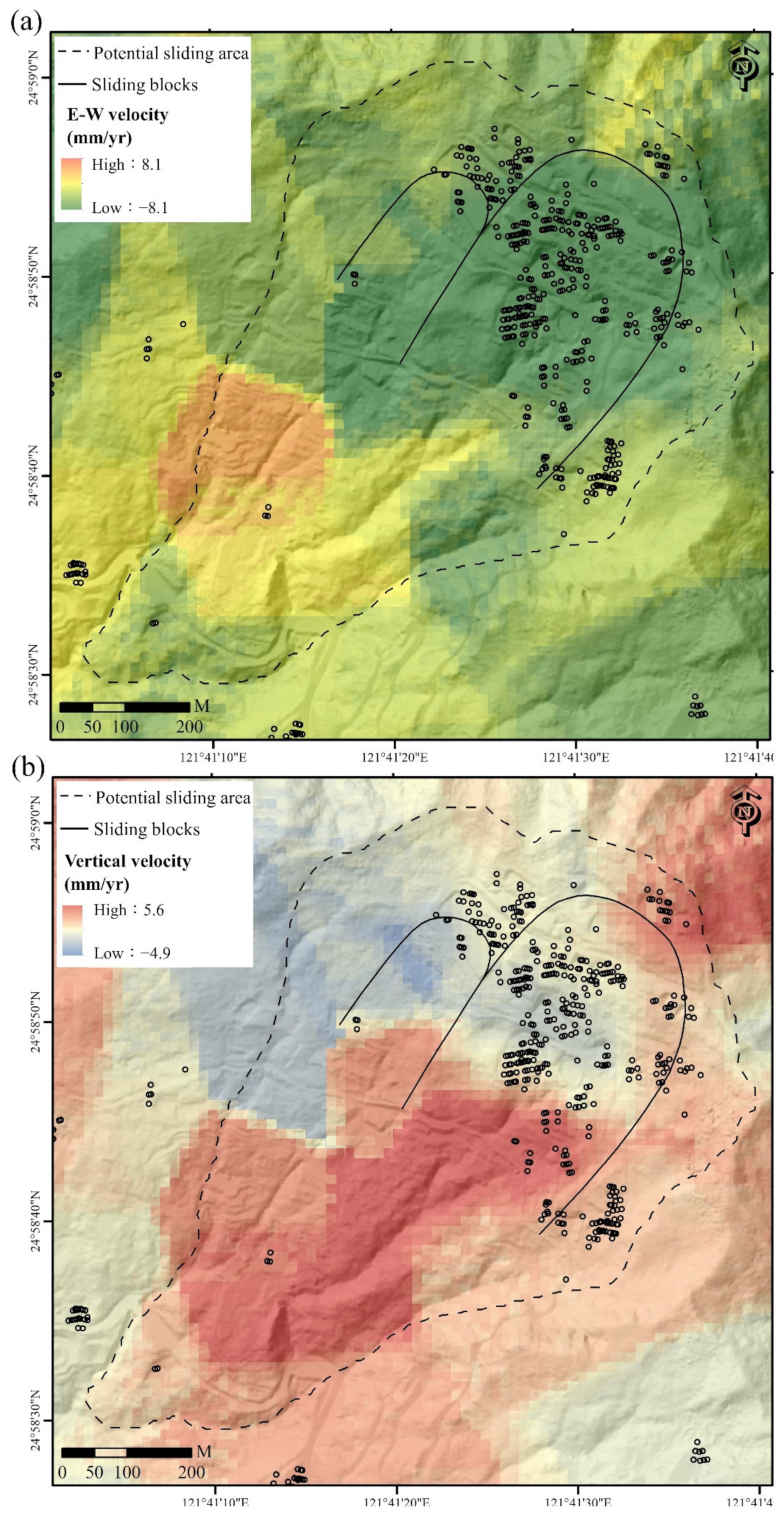
3.2. Calculation of the Projected LOS Velocity and 2D Displacement Velocity Field
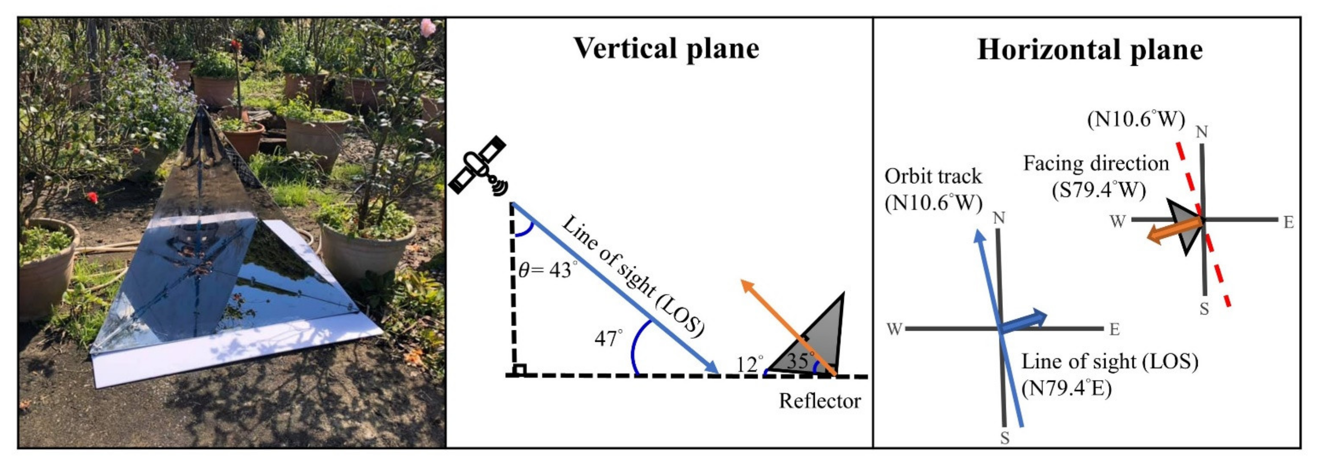
3.3. Corner Reflector Design and Deployment
4. Results
4.1. Surface Displacement Monitoring of the Slow-Moving Landslide
4.2. The Time Series of the Selected PS Pixels
5. Discussion
5.1. Projected LOS Velocity and 2D Displacement Velocity Field
5.2. Seasonal Surface Fluctuation and Gravity-Induced Deformation
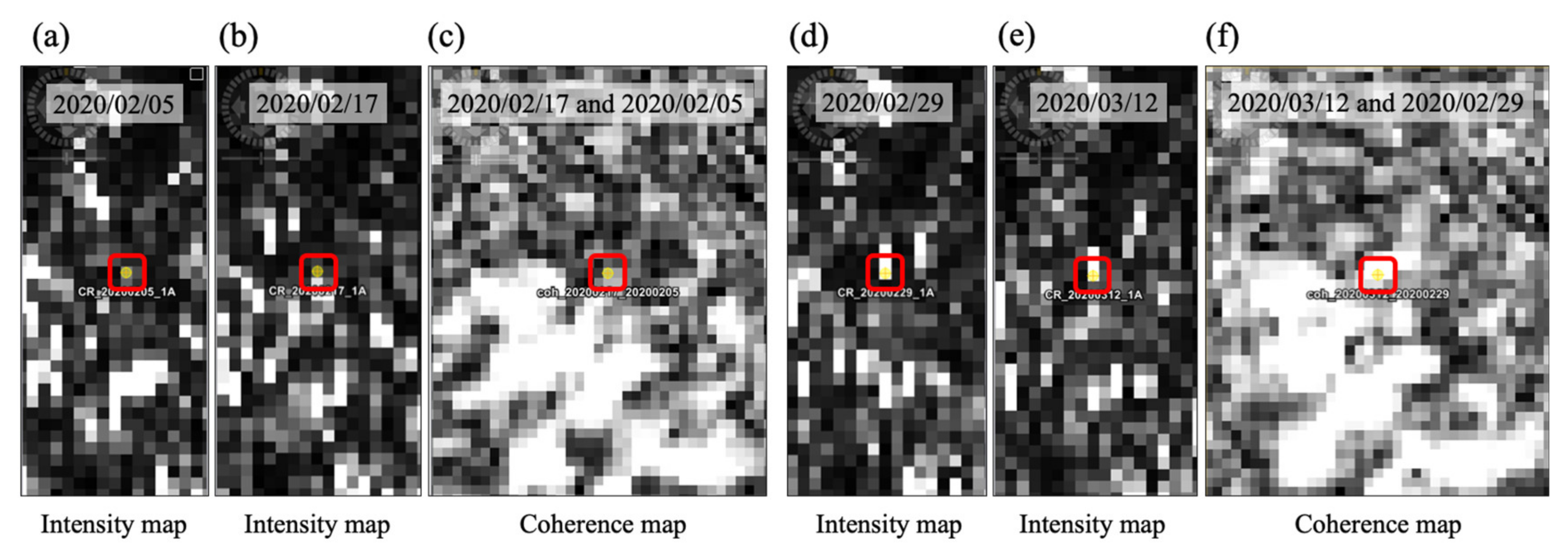
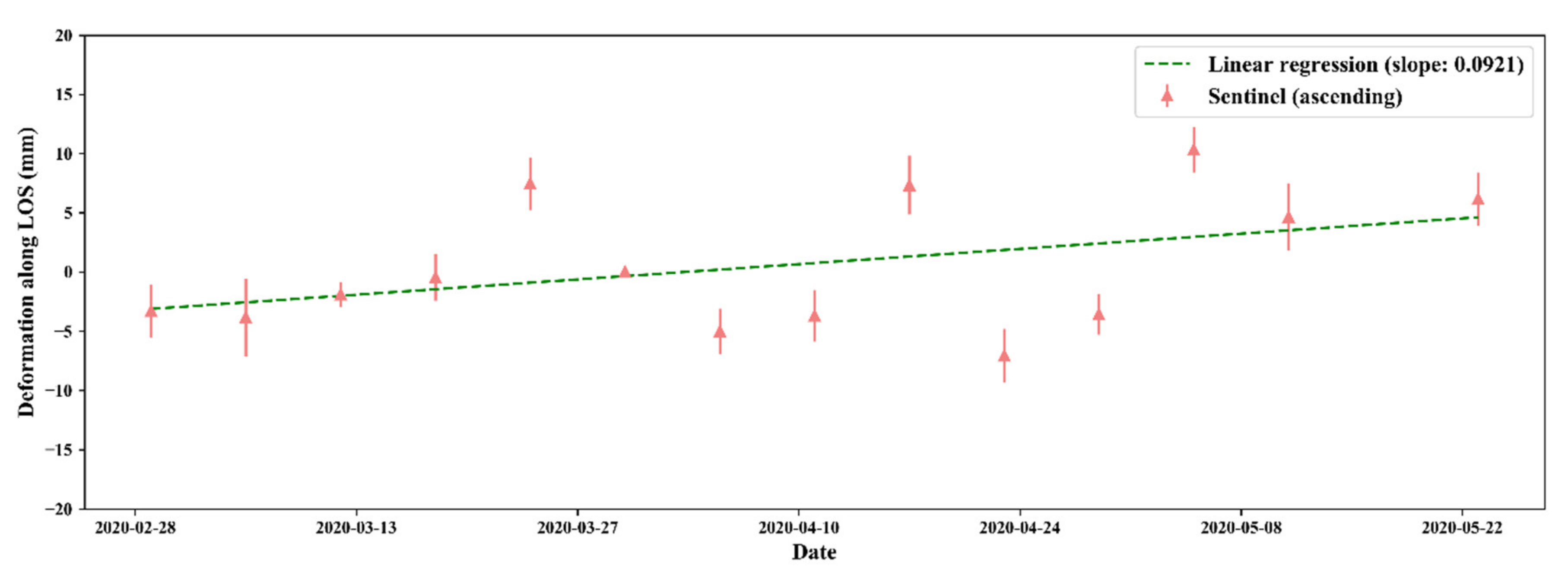
5.3. Assessment of a Corner Reflector Installed at the Huafan University Campus
6. Conclusions
- 1.
- The surface displacement pattern derived from the PSInSAR in this study is consistent with the active areas of the two sliding blocks, which were identified by field surveys and in situ monitoring data on the Huafan University campus in northern Taiwan. The PSInSAR method can compensate for the lack of in situ measurements of surface displacement.
- 2.
- According to the time series from the PS pixels, the movement of the slow-moving landslide can be divided into long period gravity-induced deformation and short period seasonal surface fluctuation. Based on the geological and hydrological conditions of this study area, the effect of pore water pressure predominated over the effect of water mass loading. The seasonal surface fluctuation is in-phase with precipitation.
- 3.
- By comparing the precipitation data from the campus and a nearby rainfall station, it was noted that the distribution of the amount of precipitation will change even in nearby areas. Therefore, the precipitation data derived from nearby rainfall stations should not be adopted directly as precipitation thresholds for an emergency evacuation due to possible landslide hazards. The installation of a rainfall gauge at the precise location of a potential landslide should be considered for evaluating possible landslide hazards.
- 4.
- The preliminary results of the corner reflector in this study provide the feasibility of applying corner reflectors in potential landslide areas in Taiwan where persistent scatterers are insufficient.
Author Contributions
Funding
Data Availability Statement
Acknowledgments
Conflicts of Interest
References
- Agliardi, F.; Crosta, G.B.; Frattini, P. Slow rock-slope deformation. In Landslides: Types, Mechanisms and Modeling; Clague, J.J., Stead, D., Eds.; Cambridge University Press: Cambridge, UK, 2013; pp. 207–221. [Google Scholar]
- Crosta, G.; Frattini, P.; Agliardi, F. Deep seated gravitational slope deformations in the European Alps. Tectonophysics 2013, 605, 13–33. [Google Scholar] [CrossRef]
- Eker, R.; Aydın, A. Long-term retrospective investigation of a large, deep-seated, and slow-moving landslide using InSAR time series, historical aerial photographs, and UAV data: The case of Devrek landslide (NW Turkey). Catena 2021, 196, 104895. [Google Scholar] [CrossRef]
- Roberds, W. Estimating temporal and spatial variability and vulnerability. In Landslide Risk Management; CRC Press: Boca Raton, FL, USA, 2005; pp. 139–168. [Google Scholar]
- Mansour, M.F.; Morgenstern, N.R.; Martin, C.D. Expected damage from displacement of slow-moving slides. Landslides 2010, 8, 117–131. [Google Scholar] [CrossRef]
- Ferlisi, S.; Gullà, G.; Nicodemo, G.; Peduto, D. A multi-scale methodological approach for slow-moving landslide risk mitigation in urban areas, southern Italy. Euro-Mediterranean J. Environ. Integr. 2019, 4, 1–15. [Google Scholar] [CrossRef] [Green Version]
- Chigira, M. Long-term gravitational deformation of rocks by mass rock creep. Eng. Geol. 1992, 32, 157–184. [Google Scholar] [CrossRef]
- Dramis, F.; Sorriso-Valvo, M. Deep-seated gravitational slope deformations, related landslides and tectonics. Eng. Geol. 1994, 38, 231–243. [Google Scholar] [CrossRef]
- Kilburn, C.R.; Petley, D.N. Forecasting giant, catastrophic slope collapse: Lessons from Vajont, Northern Italy. Geomorphology 2003, 54, 21–32. [Google Scholar] [CrossRef]
- Petley, D.N.; Higuchi, T.; Petley, D.J.; Bulmer, M.H.; Carey, J. Development of progressive landslide failure in cohesive materials. Geology 2005, 33, 201. [Google Scholar] [CrossRef]
- Kääb, A. Monitoring high-mountain terrain deformation from repeated air- and spaceborne optical data: Examples using digital aerial imagery and ASTER data. ISPRS J. Photogramm. Remote Sens. 2002, 57, 39–52. [Google Scholar] [CrossRef]
- Glenn, N.; Streutker, D.R.; Chadwick, D.J.; Thackray, G.D.; Dorsch, S.J. Analysis of LiDAR-derived topographic information for characterizing and differentiating landslide morphology and activity. Geomorphology 2006, 73, 131–148. [Google Scholar] [CrossRef]
- Kasai, M.; Ikeda, M.; Asahina, T.; Fujisawa, K. LiDAR-derived DEM evaluation of deep-seated landslides in a steep and rocky region of Japan. Geomorphology 2009, 113, 57–69. [Google Scholar] [CrossRef]
- Lillesand, T.; Kiefer, R.W.; Chipman, J. Remote Sensing and Image Interpretation, 7th ed.; John Wiley and Sons: Hoboken, NJ, USA, 2015. [Google Scholar]
- Fruneau, B.; Achache, J.; Delacourt, C. Observation and modelling of the Saint-Étienne-de-Tinée landslide using SAR interferometry. Tectonophysics 1996, 265, 181–190. [Google Scholar] [CrossRef]
- Hilley, G.E.; Bürgmann, R.; Ferretti, A.; Novali, F.; Rocca, F. Dynamics of Slow-Moving Landslides from Permanent Scatterer Analysis. Science 2004, 304, 1952–1955. [Google Scholar] [CrossRef] [Green Version]
- Bovenga, F.; Nutricato, R.; Refice, A.; Wasowski, J. Application of multi-temporal differential interferometry to slope instability detection in urban/peri-urban areas. Eng. Geol. 2006, 88, 218–239. [Google Scholar] [CrossRef]
- Colesanti, C.; Wasowski, J. Investigating landslides with space-borne Synthetic Aperture Radar (SAR) interferometry. Eng. Geol. 2006, 88, 173–199. [Google Scholar] [CrossRef]
- Notti, D.; López-Davalillo, J.C.G.; Herrera, G.; Mora, O. Assessment of the performance of X-band satellite radar data for landslide mapping and monitoring: Upper Tena Valley case study. Nat. Hazards Earth Syst. Sci. 2010, 10, 1865–1875. [Google Scholar] [CrossRef]
- Bovenga, F.; Wasowski, J.; Nitti, D.; Nutricato, R.; Chiaradia, M. Using COSMO/SkyMed X-band and ENVISAT C-band SAR interferometry for landslides analysis. Remote Sens. Environ. 2012, 119, 272–285. [Google Scholar] [CrossRef]
- Wasowski, J.; Bovenga, F. Investigating landslides and unstable slopes with satellite Multi Temporal Interferometry: Current issues and future perspectives. Eng. Geol. 2014, 174, 103–138. [Google Scholar] [CrossRef]
- Solari, L.; Del Soldato, M.; Montalti, R.; Bianchini, S.; Raspini, F.; Thuegaz, P.; Bertolo, D.; Tofani, V.; Casagli, N. A Sentinel-1 based hot-spot analysis: Landslide mapping in north-western Italy. Int. J. Remote Sens. 2019, 40, 7898–7921. [Google Scholar] [CrossRef]
- Sun, Q.; Zhang, L.; Ding, X.; Hu, J.; Li, Z.; Zhu, J. Slope deformation prior to Zhouqu, China landslide from InSAR time series analysis. Remote Sens. Environ. 2015, 156, 45–57. [Google Scholar] [CrossRef]
- Hu, X.; Wang, T.; Pierson, T.C.; Lu, Z.; Kim, J.; Cecere, T.H. Detecting seasonal landslide movement within the Cascade landslide complex (Washington) using time-series SAR imagery. Remote Sens. Environ. 2016, 187, 49–61. [Google Scholar] [CrossRef] [Green Version]
- Tomás, R.; Li, Z.; Lopez-Sanchez, J.M.; Liu, P.; Singleton, A. Using wavelet tools to analyse seasonal variations from InSAR time-series data: A case study of the Huangtupo landslide. Landslides 2015, 13, 437–450. [Google Scholar] [CrossRef] [Green Version]
- Shroder, J.F. Landslide Hazards, Risks, and Disasters; Academic Press: Amsterdam, The Netherlands, 2014. [Google Scholar]
- Jeng, C.-J.; Sue, D.-Z. Characteristics of ground motion and threshold values for colluvium slope displacement induced by heavy rainfall: A case study in northern Taiwan. Nat. Hazards Earth Syst. Sci. 2016, 16, 1309–1321. [Google Scholar] [CrossRef] [Green Version]
- Tseng, C.-H.; Chan, Y.-C.; Jeng, C.-J.; Hsieh, Y.-C. Slip monitoring of a dip-slope and runout simulation by the discrete element method: A case study at the Huafan University campus in northern Taiwan. Nat. Hazards 2017, 89, 1205–1225. [Google Scholar] [CrossRef]
- Tseng, C.-H.; Chan, Y.-C.; Jeng, C.-J.; Rau, R.-J.; Hsieh, Y.-C. Deformation of landslide revealed by long-term surficial monitoring: A case study of slow movement of a dip slope in northern Taiwan. Eng. Geol. 2021, 284, 106020. [Google Scholar] [CrossRef]
- Lu, C.-Y.; Hu, J.-C.; Chan, Y.-C.; Su, Y.-F.; Chang, C.-H. The Relationship between Surface Displacement and Groundwater Level Change and Its Hydrogeological Implications in an Alluvial Fan: Case Study of the Choshui River, Taiwan. Remote Sens. 2020, 12, 3315. [Google Scholar] [CrossRef]
- Lin, C.-C. Explanatory Text of the Geological Map of Taiwan, Hsintien; Central Geological Survey of Taiwan, MOEA: Taipei, Taiwan, 2000; p. 77, Sheet 32. (In Chinese) [Google Scholar]
- Huang, J.S.; Jeng, C.J. A supplementary geological survey and analysis of the Dalun area around the Huafan University. J. Art Design Huafan Univ 2004, 1, 59–70. (In Chinese) [Google Scholar]
- Jeng, C.J.; Hung, C.S.; Shieh, C.Y. Case study of the application of in-situ geological mapping and 2D-resistivity image explora-tion for the slope in Huafan University. J. Art Design Huafan Univ. 2008, 4, 166–180. (In Chinese) [Google Scholar]
- Ferretti, A.; Prati, C.; Rocca, F. Permanent scatterers in SAR interferometry. IEEE Trans. Geosci. Remote Sens. 2001, 39, 8–20. [Google Scholar] [CrossRef]
- Hooper, A.; Zebker, H.; Segall, P.; Kampes, B. A new method for measuring deformation on volcanoes and other natural terrains using InSAR persistent scatterers. Geophys. Res. Lett. 2004, 31, L23611. [Google Scholar] [CrossRef]
- Berardino, P.; Fornaro, G.; Lanari, R.; Sansosti, E. A new algorithm for surface deformation monitoring based on small baseline differential SAR interferograms. IEEE Trans. Geosci. Remote Sens. 2002, 40, 2375–2383. [Google Scholar] [CrossRef] [Green Version]
- Crosetto, M.; Monserrat, O.; Cuevas-González, M.; Devanthéry, N.; Crippa, B. Persistent Scatterer Interferometry: A review. ISPRS J. Photogramm. Remote Sens. 2016, 115, 78–89. [Google Scholar] [CrossRef] [Green Version]
- Hooper, A. A multi-temporal InSAR method incorporating both persistent scatterer and small baseline approaches. Geophys. Res. Lett. 2008, 35, L16302. [Google Scholar] [CrossRef] [Green Version]
- Hooper, A.; Zebker, H.A. Phase unwrapping in three dimensions with application to InSAR time series. J. Opt. Soc. Am. A 2007, 24, 2737–2747. [Google Scholar] [CrossRef] [Green Version]
- Cian, F.; Blasco, J.M.D.; Carrera, L. Sentinel-1 for Monitoring Land Subsidence of Coastal Cities in Africa Using PSInSAR: A Methodology Based on the Integration of SNAP and StaMPS. Geosciences 2019, 9, 124. [Google Scholar] [CrossRef] [Green Version]
- Blasco, J.M.D.; Foumelis, M. Automated SNAP Sentinel-1 DInSAR processing for StaMPS PSI with open source tools (1.0.1). In Proceedings of the International Geoscience and Remote Sensing Symposium 2018 (IGARSS 2018), Valencia, Spain, 22–27 July 2018. [Google Scholar] [CrossRef]
- Cigna, F.; Bianchini, S.; Casagli, N. How to assess landslide activity and intensity with Persistent Scatterer Interferometry (PSI): The PSI-based matrix approach. Landslides 2013, 10, 267–283. [Google Scholar] [CrossRef] [Green Version]
- Notti, D.; Herrera, G.; Bianchini, S.; Meisina, C.; López-Davalillo, J.C.G.; Zucca, F. A methodology for improving landslide PSI data analysis. Int. J. Remote Sens. 2014, 35, 2186–2214. [Google Scholar] [CrossRef]
- Béjar-Pizarro, M.; Notti, D.; Mateos, R.M.; Ezquerro, P.; Centolanza, G.; Herrera, G.; Bru, G.; Sanabria, M.; Solari, L.; Duro, J.; et al. Mapping Vulnerable Urban Areas Affected by Slow-Moving Landslides Using Sentinel-1 InSAR Data. Remote Sens. 2017, 9, 876. [Google Scholar] [CrossRef] [Green Version]
- Ye, X.; Kaufmann, H.; Guo, X. Landslide Monitoring in the Three Gorges Area Using D-INSAR and Corner Reflectors. Photogramm. Eng. Remote Sens. 2004, 70, 1167–1172. [Google Scholar] [CrossRef]
- Crosetto, M.; Gili, J.; Monserrat, O.; Cuevasgonzalez, M.; Corominas, J.; Serral, D. Interferometric SAR monitoring of the Vallcebre landslide (Spain) using corner reflectors. Nat. Hazards Earth Syst. Sci. 2013, 13, 923–933. [Google Scholar] [CrossRef]
- Bovenga, F.; Pasquariello, G.; Pellicani, R.; Refice, A.; Spilotro, G. Landslide monitoring for risk mitigation by using corner reflector and satellite SAR interferometry: The large landslide of Carlantino (Italy). Catena 2017, 151, 49–62. [Google Scholar] [CrossRef]
- Garthwaite, M.C. On the Design of Radar Corner Reflectors for Deformation Monitoring in Multi-Frequency InSAR. Remote Sens. 2017, 9, 648. [Google Scholar] [CrossRef] [Green Version]
- Czikhardt, R.; van der Marel, H.; van Leijen, F.J.; Hanssen, R.F. Estimating Signal-to-Clutter Ratio of InSAR Corner Reflectors from SAR Time Series. IEEE Geosci. Remote Sens. Lett. 2021, 1–5. [Google Scholar] [CrossRef]


| N–S | E–W | Vertical | |
|---|---|---|---|
| Ascending | 15% | 67% | 73% |
| Descending | 12% | 56% | 82% |
Publisher’s Note: MDPI stays neutral with regard to jurisdictional claims in published maps and institutional affiliations. |
© 2021 by the authors. Licensee MDPI, Basel, Switzerland. This article is an open access article distributed under the terms and conditions of the Creative Commons Attribution (CC BY) license (https://creativecommons.org/licenses/by/4.0/).
Share and Cite
Lu, C.-Y.; Chan, Y.-C.; Hu, J.-C.; Tseng, C.-H.; Liu, C.-H.; Chang, C.-H. Seasonal Surface Fluctuation of a Slow-Moving Landslide Detected by Multitemporal Interferometry (MTI) on the Huafan University Campus, Northern Taiwan. Remote Sens. 2021, 13, 4006. https://doi.org/10.3390/rs13194006
Lu C-Y, Chan Y-C, Hu J-C, Tseng C-H, Liu C-H, Chang C-H. Seasonal Surface Fluctuation of a Slow-Moving Landslide Detected by Multitemporal Interferometry (MTI) on the Huafan University Campus, Northern Taiwan. Remote Sensing. 2021; 13(19):4006. https://doi.org/10.3390/rs13194006
Chicago/Turabian StyleLu, Chiao-Yin, Yu-Chang Chan, Jyr-Ching Hu, Chia-Han Tseng, Che-Hsin Liu, and Chih-Hsin Chang. 2021. "Seasonal Surface Fluctuation of a Slow-Moving Landslide Detected by Multitemporal Interferometry (MTI) on the Huafan University Campus, Northern Taiwan" Remote Sensing 13, no. 19: 4006. https://doi.org/10.3390/rs13194006
APA StyleLu, C.-Y., Chan, Y.-C., Hu, J.-C., Tseng, C.-H., Liu, C.-H., & Chang, C.-H. (2021). Seasonal Surface Fluctuation of a Slow-Moving Landslide Detected by Multitemporal Interferometry (MTI) on the Huafan University Campus, Northern Taiwan. Remote Sensing, 13(19), 4006. https://doi.org/10.3390/rs13194006


