
Monitoring Metropolitan Growth Dynamics for Achieving Sustainable Urbanization (SDG 11.3) in Kolkata Metropolitan Area, India

 , ,
, ,  , and
, and
Abstract
1. Introduction
- Classifying land use and land cover (LULC) maps of KMA by applying machine learning using a support vector machine (SVM) approach.
- Implementing post-classification comparison-led change detection analysis concerning spatiotemporal dynamics in class area, percentage, and growth of LULC in KMA.
- Quantifying the spatiotemporal pattern of urban growth in KMA employing the selected landscape metrics.
- Measuring the degree of compactness and dispersion in urban growth and determining the presence and degree of urban sprawl in KMA with a black-and-white scale applying the approach.
- Preparing a set of policy recommendations and measures from the finding of the study for achieving sustainable urbanization (SDGs 11.3) and capacity for participatory, integrated, and sustainable planning and management for KMA.
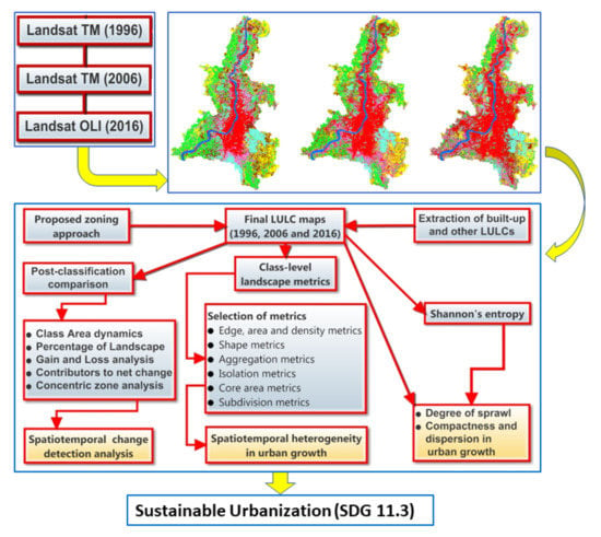
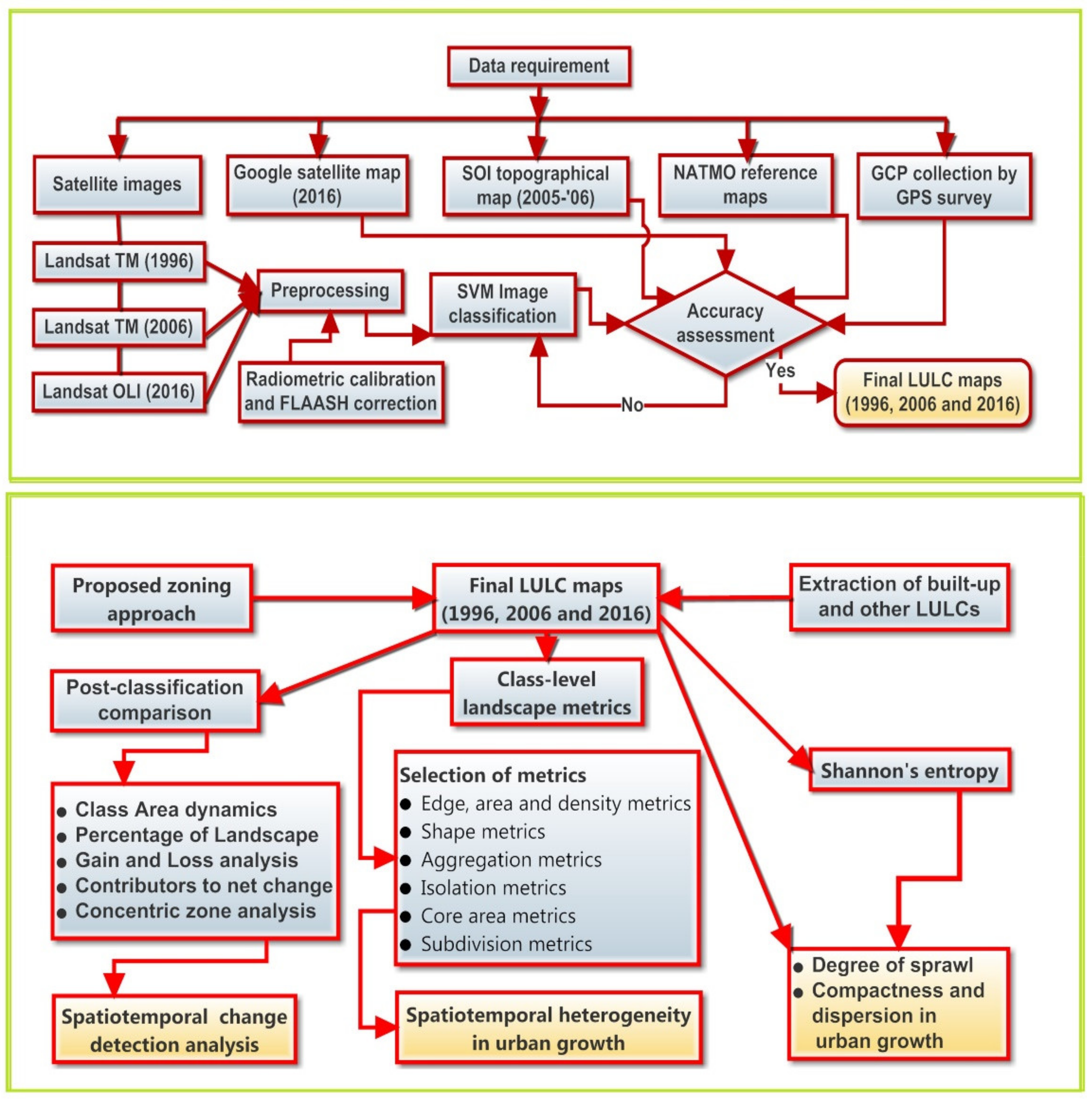
2. Materials and Methods
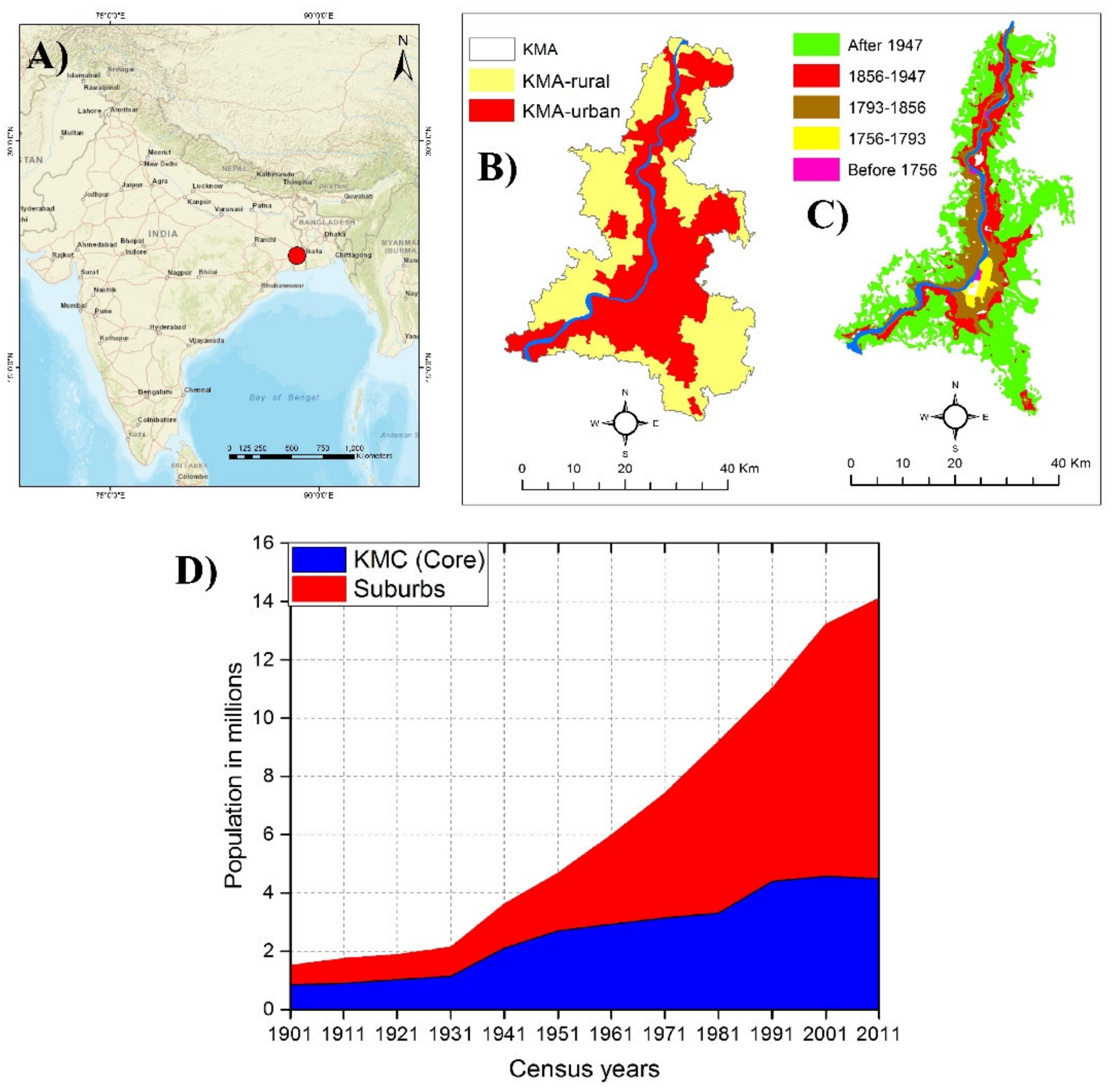
2.1. Research Area
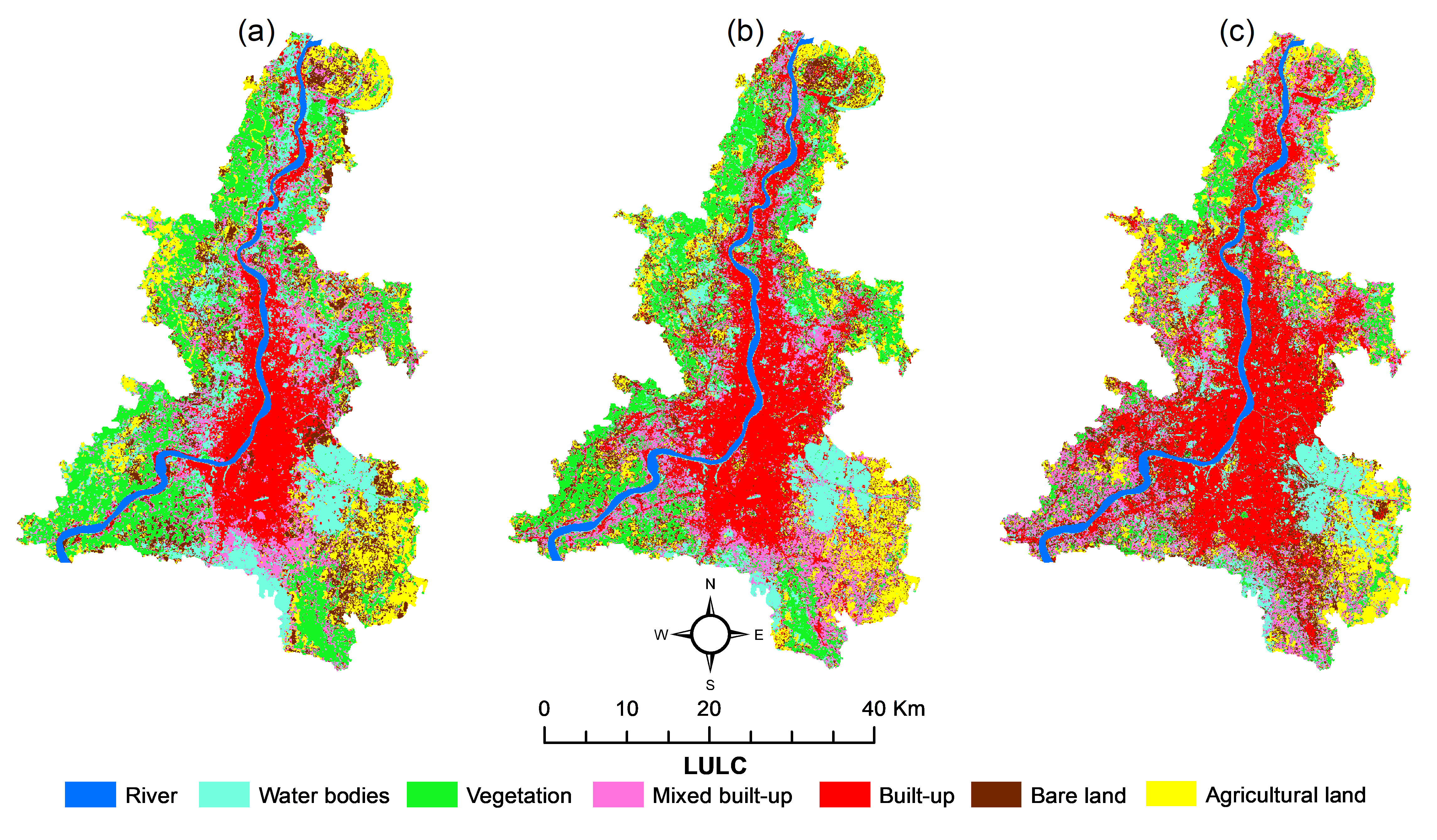
2.2. Data Source and Methodology
2.3. Landscape Metrics
2.4. Shannon’s Entropy ()
3. Results
3.1. CA and PLAND Analysis
3.2. Gain and Loss Analysis
3.3. Contributors to the Net Change in the LULCs
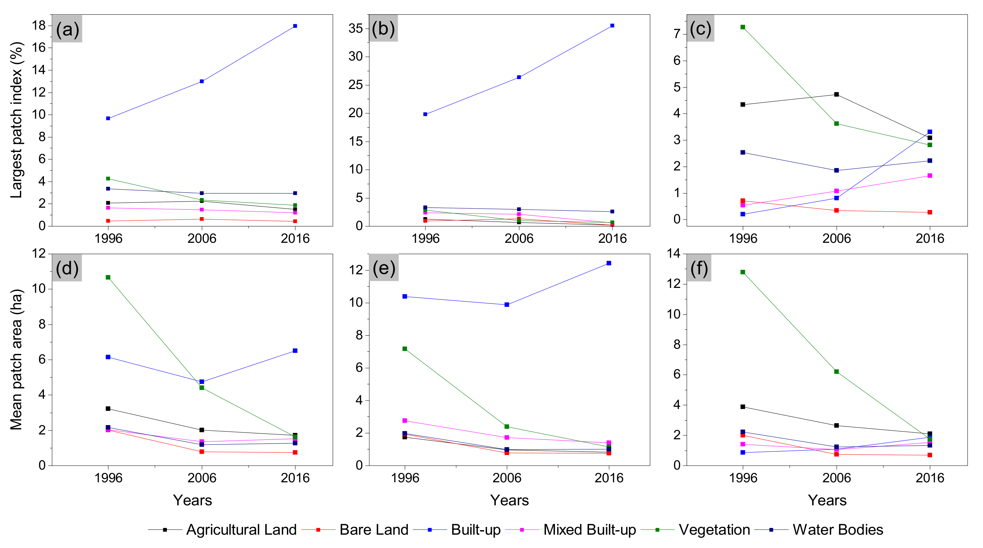
3.4. Landscape Metrics Analysis
3.5. The Analysis
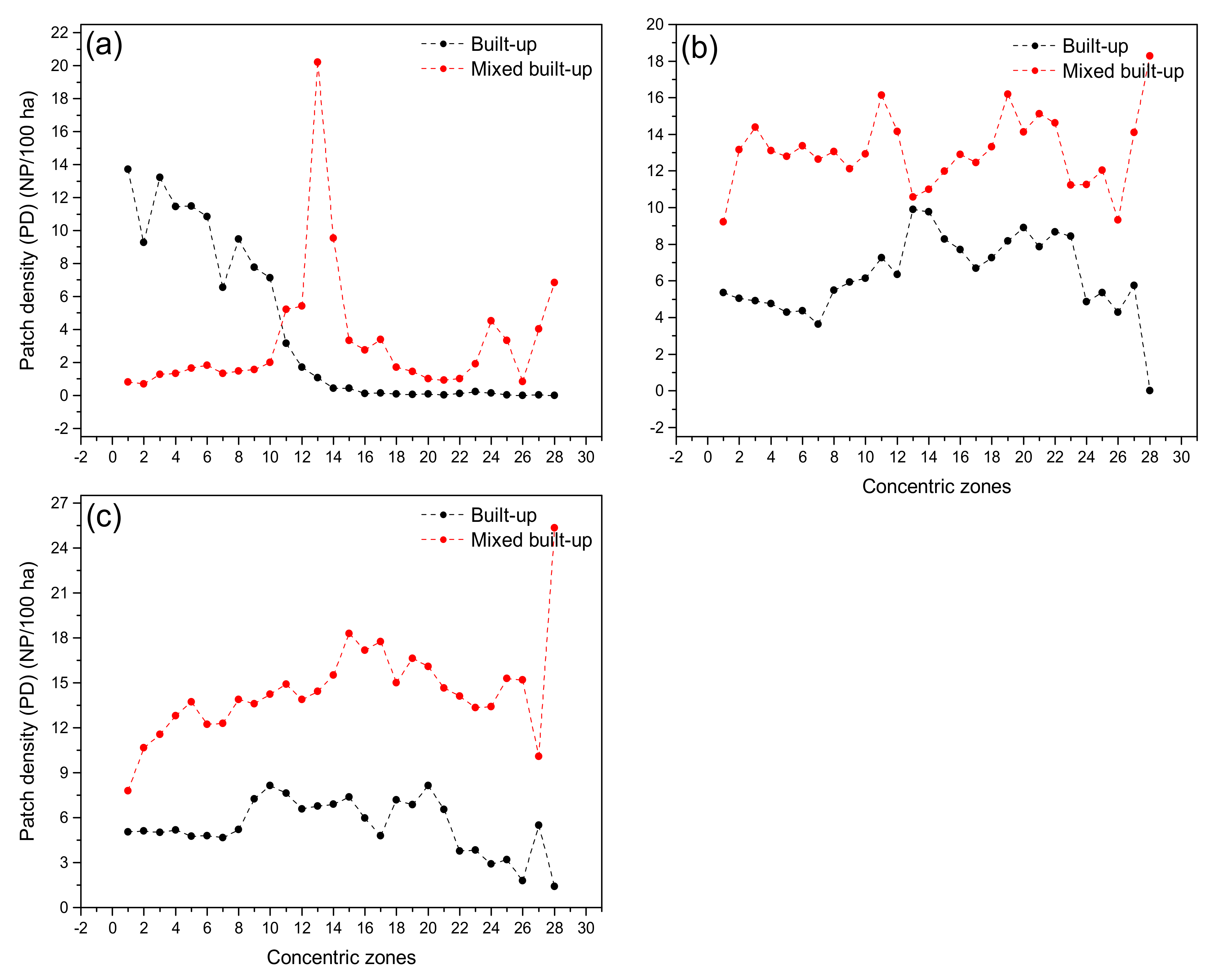
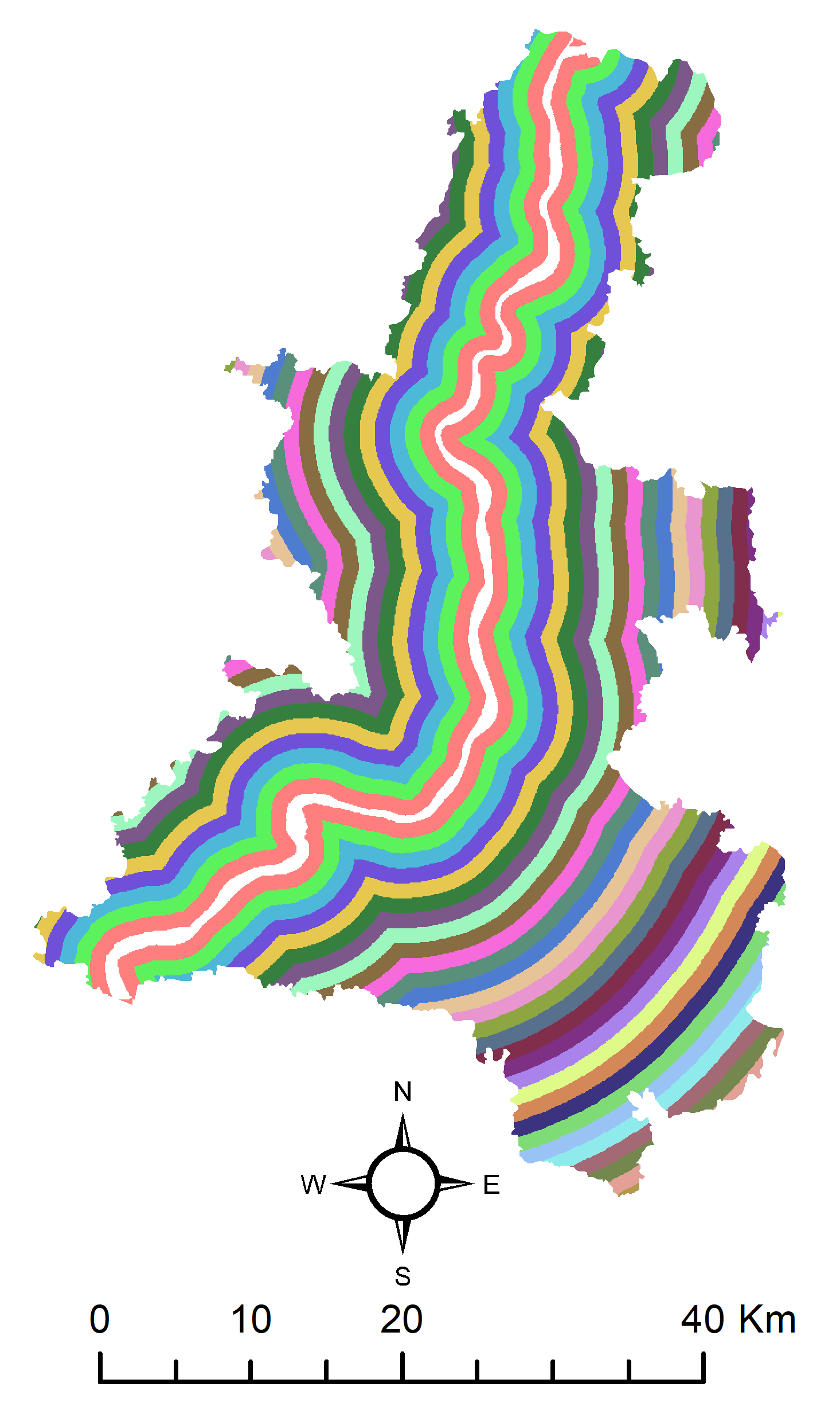
3.6. Concentric Zone Analysis
4. Discussion
5. Conclusions and Recommendations
- In the KMA, urban sprawl has irreversible negative environmental impacts. The metropolitan area’s growth has been unchecked as the suburbanization rapidly engulfs the agricultural land, vegetation cover, and water bodies, mostly in the form of mixed built-up along the periphery of KMA. Moreover, such consequences are likely to be aggravated in the coming decades. Hence, this study may be regarded as an alarm for city administrators and policymakers to gain understanding in order to take the necessary actions required for sustainable land management planning, especially for the peri-urban areas, which are more vulnerable to concretization.
- The findings of the present study indicate that the pattern and process of urban expansion vary at different levels within the KMA, that is, between KMA-urban and KMA-rural. Furthermore, within the KMA, the urban core and rural periphery differ in terms of economic structures, infrastructure development, urban amenities, local government, population growth, and other factors that are important in the urban planning process. The causal factors driving built-up development in the core and periphery in a big metropolitan such as KMA are also largely different. Therefore, in order to achieve SDG 11.3 in the KMA, urban planning and policymaking cannot be the same for the entire metropolitan system.
- In developing countries, cities grow rapidly, often in a haphazard fashion irrespective of direction. The timely long-term assessment and modeling of built-up dynamics appear to be of value in large cities like KMA for understanding the process of urban growth dynamics and for the allocation of resources in the present and future, depending upon changing scenarios required for sustainable long-term urban planning and development.
- This study found that the peripheral parts of the KMA, particularly towards the west, south-west, south, south-east, and east regions, were growing at a faster pace and are expected to accelerate with further concretization in the near future. Hence, it is timely for city administrators, the planning authorities, and policy-making bodies to consider peripheral residential development of townships compatible with environmental sustainability and with provision of proper and adequate urban amenities and infrastructures.
- Urban floods and water logging are frequent phenomena in KMA. These are also consequences of the haphazard and unplanned urban growth that has happened in KMA over the decades. To avoid such problems in the future, there is a need to have a metropolitan area as well as different spatial level identification of suitable areas favoring urban development in KMA. The suitability mapping should be based on all possible local and regional factors affecting urban growth. Future residential and infrastructural development should be strictly based on suitable areas so identified.
- In order to reduce the consequences of urban sprawl in the future, future growth should be target-based at a local and metropolitan level over time periods. Any discrepancy between actual and target growth needs to be estimated on a decadal basis in the future. Provision for urban planning should be properly integrated with target-based growth. This could promote compact urban growth and avoid leapfrogging and haphazard built-up growth in the future.
Author Contributions
Funding
Data Availability Statement
Acknowledgments
Conflicts of Interest
Appendix A

| Satellite Image | Acquisition Date | Path & Row | Land Cloud Coverage (%) | Reference System |
|---|---|---|---|---|
| Landsat TM | 16 February 1996 | 138 & 44 | Nil | UTM (Zone 45N) & WGS 84 |
| Landsat TM | 16 February 1996 | 138 & 45 | Nil | UTM (Zone 45N) & WGS 84 |
| Landsat TM | 12 December 1996 | 138 & 44 | ≤2 | UTM (Zone 45N) & WGS 84 |
| Landsat TM | 12 December 1996 | 138 & 45 | ≤2 | UTM (Zone 45N) & WGS 84 |
| Landsat OLI | 7 December 1996 | 138 & 44 | <1 | UTM (Zone 45N) & WGS 84 |
Appendix B
| Classes | Definition and Description |
|---|---|
| Built-up areas | All impervious structures (e.g., asphalt, concrete, etc.) typically residential, commercial and industrial areas, village settlements, and transport infrastructures. |
| Mixed built-up | Built-up cover mixed with vegetation and other no built-up cover. |
| Water bodies | River, canals, ponds, reservoirs, wetlands, lakes, marshy land, and other permanent water bodies. |
| Vegetation | Trees, mixed forest, shrub, and semi-natural forests. |
| Agricultural land | Crop or cultivated land and pasture, playground, parks, lawn, dumping station, grassland, and other urban recreational areas. |
| Bare land | All types of fallow or barren lands such as open space, abandoned and unirrigated areas, bare exposed rocks and soils, transitional areas, salt flats, sandy areas, etc. |
Appendix C

Appendix D
| Classified data | Reference Data | ||||||||
| Classes * | 1 | 2 | 3 | 4 | 5 | 6 | Row Total | UA (%) | |
| 1 | 59 | 0 | 0 | 0 | 5 | 2 | 66 | 89.39 | |
| 2 | 0 | 87 | 2 | 0 | 4 | 0 | 93 | 93.55 | |
| 3 | 0 | 0 | 53 | 5 | 0 | 4 | 62 | 85.48 | |
| 4 | 0 | 0 | 3 | 56 | 2 | 3 | 64 | 87.50 | |
| 5 | 3 | 2 | 0 | 0 | 57 | 1 | 63 | 90.48 | |
| 6 | 0 | 0 | 1 | 2 | 2 | 47 | 52 | 90.38 | |
| Column total | 62 | 89 | 59 | 63 | 70 | 57 | 400 | ||
| PA (%) | 95.16 | 97.75 | 89.83 | 88.89 | 81.43 | 82.46 | |||
| OA = 89.75% Kappa = 0.8790 | |||||||||
| Classified data | Reference Data | ||||||||
| Classes * | 1 | 2 | 3 | 4 | 5 | 6 | Row Total | UA (%) | |
| 1 | 50 | 1 | 0 | 0 | 2 | 0 | 53 | 94.34 | |
| 2 | 0 | 69 | 3 | 0 | 3 | 0 | 75 | 92.00 | |
| 3 | 0 | 1 | 58 | 3 | 1 | 0 | 63 | 92.06 | |
| 4 | 0 | 0 | 5 | 88 | 0 | 2 | 95 | 92.63 | |
| 5 | 1 | 2 | 0 | 0 | 60 | 1 | 64 | 93.75 | |
| 6 | 0 | 0 | 1 | 5 | 1 | 43 | 50 | 86.00 | |
| Column total | 51 | 73 | 67 | 96 | 67 | 46 | 400 | ||
| PA (%) | 98.04 | 94.52 | 86.57 | 91.67 | 89.55 | 93.48 | |||
| OA = 92.00% Kappa = 0.9046 | |||||||||
| Classified data | Reference Data | ||||||||
| Classes * | 1 | 2 | 3 | 4 | 5 | 6 | Row Total | UA (%) | |
| 1 | 54 | 0 | 0 | 0 | 1 | 0 | 55 | 98.18 | |
| 2 | 0 | 51 | 1 | 0 | 2 | 0 | 54 | 94.44 | |
| 3 | 0 | 0 | 62 | 3 | 0 | 0 | 65 | 95.38 | |
| 4 | 0 | 0 | 3 | 112 | 1 | 2 | 118 | 94.92 | |
| 5 | 2 | 5 | 0 | 0 | 48 | 3 | 58 | 82.76 | |
| 6 | 0 | 0 | 0 | 4 | 2 | 44 | 50 | 88.00 | |
| Column total | 56 | 56 | 66 | 119 | 54 | 49 | 400 | ||
| PA (%) | 96.43 | 91.07 | 93.94 | 94.12 | 88.89 | 89.80 | |||
| OA = 92.75% Kappa = 0.9124 | |||||||||
Appendix E
| Levels | Years | Areas under the LULCs (ha) | |||||
|---|---|---|---|---|---|---|---|
| Agricultural Land | Bare Land | Built-Up | Mixed Built-Up | Vegetation | Water Bodies | ||
| KMA | 1996 | 27,423.18 | 22,391.46 | 27,781.65 | 26,995.68 | 40,090.86 | 28,381.05 |
| 2006 | 27,782.64 | 21,190.86 | 41,439.87 | 27,329.58 | 32,273.01 | 23,042.52 | |
| 2016 | 25,121.88 | 21,751.56 | 54,419.85 | 30,193.02 | 17,273.70 | 23,919.21 | |
| KMA-urban | 1996 | 6602.58 | 8453.97 | 25,885.62 | 15,737.85 | 14,221.17 | 13,313.79 |
| 2006 | 6243.48 | 8787.24 | 35,811.99 | 14,924.52 | 9435.78 | 9007.29 | |
| 2016 | 5185.53 | 9627.39 | 45,232.47 | 10,978.47 | 3794.22 | 9369.36 | |
| KMA-rural | 1996 | 20,820.6 | 13,937.49 | 1896.03 | 11,257.83 | 25,869.69 | 15,067.26 |
| 2006 | 21,539.16 | 12,403.62 | 5627.88 | 12,405.06 | 22,837.23 | 14,035.23 | |
| 2016 | 19,936.35 | 12,124.17 | 9187.38 | 19,214.55 | 13,479.48 | 14,549.85 | |
Appendix F

References
- Forman, R.T.T. Land Mosaics: The Ecology of Landscapes and Regions; Cambridge University Press: Cambridge, MA, USA, 1995. [Google Scholar]
- Wasserman, M. Urban sprawl. Reg. Rev. 2000, 10, 9–17. [Google Scholar]
- Ramachandra, T.V.; Aithal, B.H.; Sanna, D.D. Insights to urban dynamics through landscape spatial pattern analysis. Int. J. Appl. Earth Obs. Geoinf. 2012, 18, 329–343. [Google Scholar] [CrossRef]
- Mithun, S.; Chattopadhyay, S.; Bhatta, B. Analyzing urban dynamics of metropolitan Kolkata, India by using landscape metrics. Pap. Appl. Geogr. 2016, 2, 284–297. [Google Scholar] [CrossRef]
- Wilson, B.; Chakraborty, A. The environmental impacts of sprawl: Emergent themes from the past decade of planning research. Sustainability 2013, 5, 3302–3327. [Google Scholar] [CrossRef]
- Torrens, P.M.; Alberti, M. Measuring Sprawl; Centre for Advanced Spatial Analysis (UCL): London, UK, 2000. [Google Scholar]
- Rahman, A.; Aggarwal, S.P.; Netzband, M.; Fazal, S. Monitoring urban sprawl using remote sensing and GIS techniques of a fast growing urban centre, India. IEEE J. Sel. Top. Appl. Earth Obs. Remote Sens. 2011, 4, 56–64. [Google Scholar] [CrossRef]
- Pandey, A.C.; Kumar, A.; Jeyaseelan, A.T. Urban built-up area assessment of Ranchi township using Cartosat-I stereopairs satellite images. J. Indian Soc. Remote Sens. 2013, 41, 141–155. [Google Scholar] [CrossRef]
- Yeh, A.G.O.; Li, X. A constrained CA model for the simulation and planning of sustainable urban forms by using GIS. Environ. Plann. B Plann. Des. 2001, 28, 733–753. [Google Scholar] [CrossRef]
- Kumar, J.A.V.; Pathan, S.K.; Bhanderi, R.J. Spatio-temporal analysis for monitoring urban growth—A case study of Indore city. J. Indian Soc. Remote Sens. 2007, 35, 11–20. [Google Scholar] [CrossRef]
- Lata, K.M.; Rao, C.S.; Prasad, V.K.; Badarianth, K.V.S.; Rahgavasamy, V. Measuring urban sprawl: A case study of Hyderabad. GIS Dev. 2001, 5, 26–29. [Google Scholar]
- Bhatta, B.; Saraswati, S.; Bandyopadhyay, D. Quantifying the degree-of-freedom, degree-of-sprawl, and degree-of-goodness of urban growth from remote sensing data. Appl. Geogr. 2010, 30, 96–111. [Google Scholar] [CrossRef]
- Bhatta, B.; Saraswati, S.; Bandyopadhyay, D. Urban sprawl measurement from remote sensing data. Appl. Geogr. 2010, 30, 731–740. [Google Scholar] [CrossRef]
- McGarigal, K.; Marks, B.J. FRAGSTATS: Spatial Pattern Analysis Program for Quantifying Landscape Structure; Forest Science Department, Oregon State University: Portland, OR, USA, 1994. [Google Scholar]
- Herold, M.; Scepan, J.; Clarke, K.C. The use of remote sensing and landscape metrics to describe structures and changes in urban land uses. Environ. Plan. A 2002, 34, 1443–1458. [Google Scholar] [CrossRef]
- Cabral, P.; Geroyannis, H.; Gilg, J.P.; Painho, M. Analysis and Modeling of Land-Use and Land-Cover Change in Sintra-Cascais Area. In Proceedings of the 8th AGILE Conference on Geographic Information Science, Columbus, OH, USA, 26–28 May 2005; pp. 51–60. [Google Scholar]
- Jat, M.K.; Garg, P.K.; Khare, D. Modelling of urban growth using spatial analysis techniques: A case study of Ajmer city (India). Int. J. Remote Sens. 2008, 29, 543–567. [Google Scholar] [CrossRef]
- Herold, M.; Goldstein, N.C.; Clarke, K.C. The spatiotemporal form of urban growth: Measurement, analysis and modeling. Remote Sens. Environ. 2003, 86, 286–302. [Google Scholar] [CrossRef]
- Punia, M.; Singh, L. Entropy approach for assessment of urban growth: A case study of Jaipur, India. J. Indian Soc. Remote Sens. 2012, 40, 231–244. [Google Scholar] [CrossRef]
- Bhatta, B. Analysis of urban growth pattern using remote sensing and GIS: A case study of Kolkata, India. Int. J. Remote Sens. 2009, 30, 4733–4746. [Google Scholar] [CrossRef]
- Wang, L.; Ma, L.; Song, F.; Zuo, D. Dynamics analysis of crop-landscape of agri-grazing-ecotone in Hobq desert. Res. Agric. Mod. 2009, 30, 595–598. [Google Scholar]
- Avtar, R.; Aggarwal, R.; Kumar, P.; Kharrazi, A.; Kurniawan, T.A. Utilizing Geospatial Information to Implement SDGs and Monitor their Progress. Environ. Monit. Assess. 2019, 192, 35. [Google Scholar] [CrossRef] [PubMed]
- Mondejar, M.E.; Avtar, R.; Diaz, H.L.B.; Dubey, R.K.; Esteban, J.; Gomez-Morales, A.; Hallam, B.; Mbungu, N.T.; Okolo, C.C.; Prasad, K.A.; et al. Digitalization to achieve sustainable development goals: Steps towards a Smart Green Planet. Sci. Total Environ. 2021, 794, 148539. [Google Scholar] [CrossRef]
- Mithun, S.; Chattopadhyay, S. Analyzing Spatio-Temporal Growth Dynamics of Kolkata Metropolitan Area (KMA). In Proceedings of the 12th International Asian Urbanization Conference, Varanasi, India, 28–30 December 2013. [Google Scholar]
- Singh, A. Review article digital change detection techniques using remotely-sensed data. Int. J. Remote Sens. 1989, 10, 989–1003. [Google Scholar] [CrossRef]
- Zaki, R.; Zaki, A.; Ahmed, S. Land use and land cover changes in arid region: The case new urbanized zone, northeast Cairo, Egypt. J. Geogr. Inf. Syst. 2011, 3, 173–194. [Google Scholar] [CrossRef]
- Sahana, M.; Hong, H.; Sajjad, H. Analyzing urban spatial patterns and trend of urban growth using urban sprawl matrix: A study on Kolkata urban agglomeration, India. Sci. Total Environ. 2018, 628–629, 1557–1566. [Google Scholar] [CrossRef] [PubMed]
- Mitra, C.; Shepherd, J.M.; Jordan, T.R. Assessment and Dynamics of Urban Growth in the City of Kolkata. In Facets of Social Geography: International and Indian Perspectives; Ashok, K.D., Wadhwa, V., Thakur, B., Costa, F.J., Eds.; Foundation Books: Delhi, India, 2012; pp. 541–555. [Google Scholar]
- KMDA. KMDA Annual Report. 2008. Available online: http://www.kmdaonline.org/html/aar_2011.php (accessed on 5 December 2019).
- Census of India. Final Population Totals. 2011. Available online: http://censusindia.gov.in/2011census/censusinfodashboard/index.html (accessed on 10 December 2019).
- Landis, J.R.; Koch, G.G. An application of hierarchical Kappa-type statistics in the assessment of majority agreement among multiple observers. Biometrics 1977, 33, 159–174. [Google Scholar] [CrossRef]
- Yuan, F.; Sawaya, K.E.; Loeffelholz, B.C.; Bauer, M.E. Land cover classification and change analysis of the Twin Cities (Minnesota) Metropolitan Area by multitemporal Landsat remote sensing. Remote Sens. Environ. 2005, 98, 317–328. [Google Scholar] [CrossRef]
- O’Neill, R.V.; Krummel, J.R.; Gardner, R.E.A.; Sugihara, G.; Jackson, B.; DeAngelis, D.L.; Milne, B.T.; Turner, M.G.; Zygmunt, B.; Christensen, S.W.; et al. Indices of landscape pattern. Landsc. Ecol. 1988, 1, 153–162. [Google Scholar] [CrossRef]
- Gustafson, E.J. Quantifying landscape spatial pattern: What is the state of the art? Ecosystems 1998, 1, 143–156. [Google Scholar] [CrossRef]
- Geoghegan, J.; Wainger, L.A.; Bockstael, N.E. Spatial landscape indices in a hedonic framework: An ecological economics analysis using GIS. Ecol. Econ. 1997, 23, 251–264. [Google Scholar] [CrossRef]
- Alberti, M.; Waddell, P. An integrated urban development and ecological simulation model. Integr. Assess. 2000, 1, 215–227. [Google Scholar] [CrossRef]
- Parker, D.C.; Evans, T.; Meretsky, V. Measuring Emergent Properties of Agent-Based Landcover/Landuse Models using Spatial Metrics. In Proceedings of the 7th Annual Conference of the International Society for Computational Economics, New Haven, CT, USA, 28–29 June 2001. [Google Scholar]
- Taubenböck, H.; Esch, T.; Felbier, A.; Wiesner, M.; Roth, A.; Dech, S. Monitoring urbanization in mega cities from space. Remote Sens. Environ. 2012, 117, 162–176. [Google Scholar] [CrossRef]
- Zhang, Q. Spatial-Temporal Patterns of Urban Growth in Shanghai, China: Monitoring, Analysis, and Simulation. Ph.D. Thesis, School of Architecture and Built Environment, KTH Royal Institute of Technology, Stockholm, Sweden, 2009. [Google Scholar]
- Pham, H.M.; Yamaguchi, Y.; Bui, T.Q. A case study on the relation between city planning and urban growth using remote sensing and spatial metrics. Landsc. Urban Plan. 2011, 100, 223–230. [Google Scholar] [CrossRef]
- Tian, G.; Jiang, J.; Yang, Z.; Zhang, Y. The urban growth, size distribution and spatio-temporal dynamic pattern of the Yangtze River delta megalopolitan region, China. Ecol. Model. 2011, 222, 865–878. [Google Scholar] [CrossRef]
- Kong, F.; Yin, H.; Nakagoshi, N.; James, P. Simulating urban growth processes incorporating a potential model with spatial metrics. Ecol. Indic. 2012, 20, 82–91. [Google Scholar] [CrossRef]
- Lü, Y.; Feng, X.; Chen, L.; Fu, B. Scaling effects of landscape metrics: A comparison of two methods. Phys. Geogr. 2013, 34, 40–49. [Google Scholar] [CrossRef]
- Wu, W.; Zhao, S.; Zhu, C.; Jiang, J. A comparative study of urban expansion in Beijing, Tianjin and Shijiazhuang over the past three decades. Landsc. Urban Plan. 2015, 134, 93–106. [Google Scholar] [CrossRef]
- Hardin, P.J.; Jackson, M.W.; Otterstrom, S.M. Mapping, Measuring, and Modeling Urban Growth. In Geo-Spatial Technologies in Urban Environments; Jensen, R.R., Gatrell, J.D., McLean, D., Eds.; Springer: Berlin/Heidelberg, Germany, 2007; pp. 165–166. [Google Scholar]
- Cushman, S.A.; McGarigal, K.; Neel, M.C. Parsimony in landscape metrics: Strength, universality, and consistency. Ecol. Indic. 2008, 8, 691–770. [Google Scholar] [CrossRef]
- Bhatta, B. Urban Growth Analysis and Remote Sensing: A Case Study of Kolkata, India 1980–2010; Springer: Dordrecht, The Netherlands, 2012. [Google Scholar]
- Araya, Y.H.; Cabral, P. Analysis and modeling of urban land cover change in Setúbal and Sesimbra, Portugal. Remote Sens. 2010, 2, 1549–1563. [Google Scholar] [CrossRef]
- McGarigal, K.; Cushman, S. Comparative evaluation approaches to the study of habitat fragmentation. Ecol. Appl. 2002, 12, 335–345. [Google Scholar] [CrossRef]
- Li, X.; Yeh, A.G.O. Analyzing spatial restructuring of land use patterns in a fast growing region using remote sensing and GIS. Landsc. Urban Plan. 2004, 69, 335–354. [Google Scholar] [CrossRef]
- Thomas, R.W. Information Statistics in Geography. Concepts and Techniques in Modern Geography; The Invicta Press: Ashford Kent, UK, 1981. [Google Scholar]
- Yeh, A.G.O.; Li, X. Measurement and monitoring of urban sprawl in a rapidly growing region using entropy. Photogramm. Eng. Remote Sens. 2001, 67, 83–90. [Google Scholar]
- Smith, D.M. Patterns in Human Geography; Penguin: Harmondsworth, UK, 1975. [Google Scholar]
- Tsai, Y. Quantifying urban form: Compactness versus “sprawl”. Urban Stud. 2005, 42, 141–161. [Google Scholar] [CrossRef]
- Mithun, S. Quantifying and modeling metropolitan growth dynamics: A case study on Kolkata Metropolitan Area. Ph.D. Thesis, Indian Institute of Technology Kharagpur, Kharagpur, India, 2020. [Google Scholar]
- Sudhira, H.S.; Ramachandra, T.V.; Jagadish, K.S. Urban sprawl: Metrics, dynamics and modelling using GIS. Int. J. Appl. Earth Obs. Geoinf. 2004, 5, 29–39. [Google Scholar] [CrossRef]
- Cox, W. The Evolving Urban Form: Kolkata: 50 Mile City. 2012. Available online: http://www.newgeography.com/content/002620-the-evolving-urban-form-kolkata-50-mile-city (accessed on 10 December 2019).
- Rahman, M.; Avtar, R.; Yunus, A.P.; Dou, J.; Misra, P.; Takeuchi, W.; Sahu, N.; Kumar, P.; Johnson, B.A.; Dasgupta, R.; et al. Monitoring Effect of Spatial Growth on Land Surface Temperature in Dhaka. Remote Sens. 2020, 12, 1191. [Google Scholar] [CrossRef]


| Year | Overall Accuracy (OA) | Kappa Index |
|---|---|---|
| 1996 | 89.75% | 0.879 |
| 2006 | 92.00% | 0.904 |
| 2016 | 92.75% | 0.912 |
| Levels | Periods | Land Use Land Covers (LULCs) | |||||
|---|---|---|---|---|---|---|---|
| Agricultural Land | Bare Land | Built-Up | Mixed Built-Up | Vegetation | Water Bodies | ||
| (%) | (%) | (%) | (%) | (%) | (%) | ||
| KMA | 1996–2006 | 1.31 | −5.36 | 49.16 | 1.24 | −19.5 | −18.81 |
| 2006–2016 | −9.58 | 2.65 | 31.32 | 10.48 | −46.48 | 3.8 | |
| 1996–2016 | −8.39 | −2.86 | 95.88 | 11.84 | −56.91 | −15.72 | |
| KMA-urban | 1996–2006 | −5.44 | 3.94 | 38.35 | −5.17 | −33.65 | −32.35 |
| 2006–2016 | −16.94 | 9.56 | 26.31 | −26.44 | −59.79 | 4.02 | |
| 1996–2016 | −21.46 | 13.88 | 74.74 | −30.24 | −73.32 | −29.63 | |
| KMA-rural | 1996–2006 | 3.45 | −11.01 | 196.82 | 10.19 | −11.72 | −6.85 |
| 2006–2016 | −7.44 | −2.25 | 63.25 | 54.89 | −40.98 | 3.67 | |
| 1996–2016 | −4.25 | −13.01 | 384.56 | 70.68 | −47.89 | −3.43 | |
| Years | Levels | Shannon’s Entropy () | Log(n) | ||||
|---|---|---|---|---|---|---|---|
| Built-Up | Mixed Built-Up | All Built-Up | Built-Up | Mixed Built-Up | All Built-Up | ||
| 1996 | KMA | 1.15 | 1.63 | 1.48 | 1.89 | 1.89 | 1.89 |
| KMA-urban | 1.04 | 1.38 | 1.24 | 1.63 | 1.63 | 1.63 | |
| KMA-rural | 1.21 | 1.29 | 1.30 | 1.53 | 1.53 | 1.53 | |
| 2006 | KMA | 1.35 | 1.59 | 1.60 | 1.89 | 1.89 | 1.89 |
| KMA-urban | 1.19 | 1.37 | 1.30 | 1.63 | 1.63 | 1.63 | |
| KMA-rural | 1.31 | 1.30 | 1.20 | 1.53 | 1.53 | 1.53 | |
| 2016 | KMA | 1.45 | 1.63 | 1.61 | 1.89 | 1.89 | 1.89 |
| KMA-urban | 1.29 | 1.38 | 1.36 | 1.63 | 1.63 | 1.63 | |
| KMA-rural | 1.35 | 1.34 | 1.31 | 1.53 | 1.53 | 1.53 | |
Publisher’s Note: MDPI stays neutral with regard to jurisdictional claims in published maps and institutional affiliations. |
© 2021 by the authors. Licensee MDPI, Basel, Switzerland. This article is an open access article distributed under the terms and conditions of the Creative Commons Attribution (CC BY) license (https://creativecommons.org/licenses/by/4.0/).
Share and Cite
Mithun, S.; Sahana, M.; Chattopadhyay, S.; Johnson, B.A.; Khedher, K.M.; Avtar, R. Monitoring Metropolitan Growth Dynamics for Achieving Sustainable Urbanization (SDG 11.3) in Kolkata Metropolitan Area, India. Remote Sens. 2021, 13, 4423. https://doi.org/10.3390/rs13214423
Mithun S, Sahana M, Chattopadhyay S, Johnson BA, Khedher KM, Avtar R. Monitoring Metropolitan Growth Dynamics for Achieving Sustainable Urbanization (SDG 11.3) in Kolkata Metropolitan Area, India. Remote Sensing. 2021; 13(21):4423. https://doi.org/10.3390/rs13214423
Chicago/Turabian StyleMithun, Sk, Mehebub Sahana, Subrata Chattopadhyay, Brian Alan Johnson, Khaled Mohamed Khedher, and Ram Avtar. 2021. "Monitoring Metropolitan Growth Dynamics for Achieving Sustainable Urbanization (SDG 11.3) in Kolkata Metropolitan Area, India" Remote Sensing 13, no. 21: 4423. https://doi.org/10.3390/rs13214423
APA StyleMithun, S., Sahana, M., Chattopadhyay, S., Johnson, B. A., Khedher, K. M., & Avtar, R. (2021). Monitoring Metropolitan Growth Dynamics for Achieving Sustainable Urbanization (SDG 11.3) in Kolkata Metropolitan Area, India. Remote Sensing, 13(21), 4423. https://doi.org/10.3390/rs13214423