A New Approach for Identification of Potential Rockfall Source Areas Controlled by Rock Mass Strength at a Regional Scale
Abstract
:1. Introduction
2. Materials and Methods
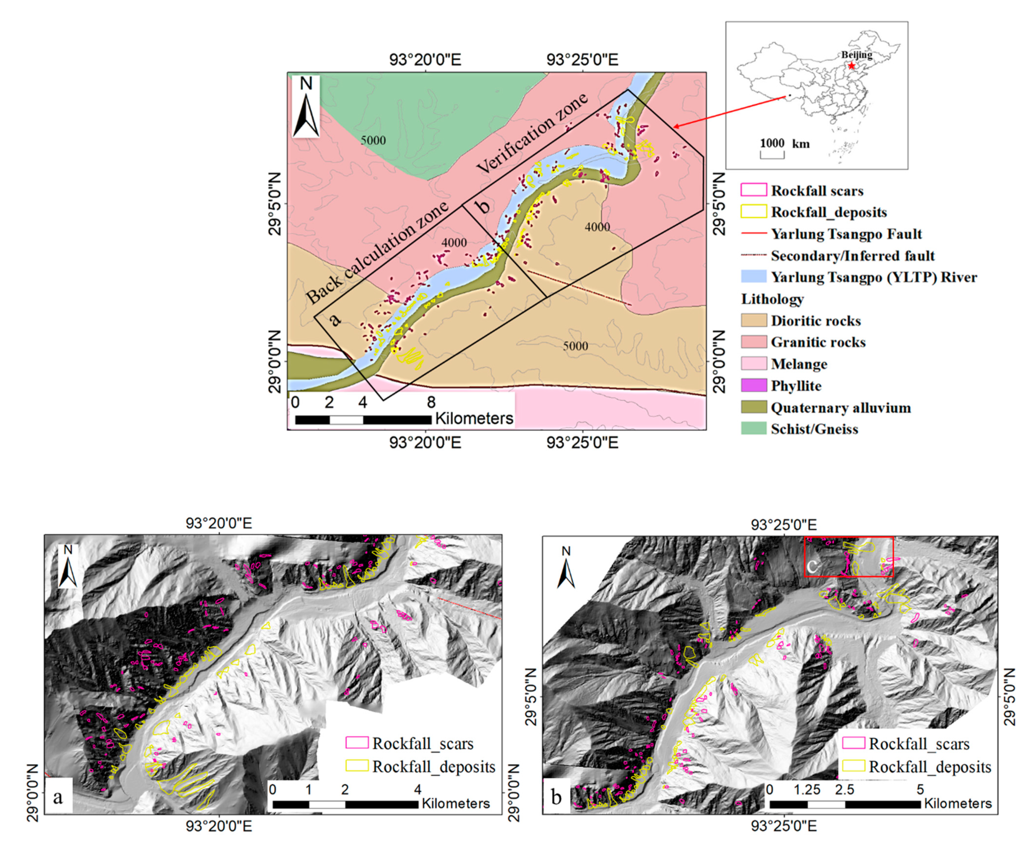
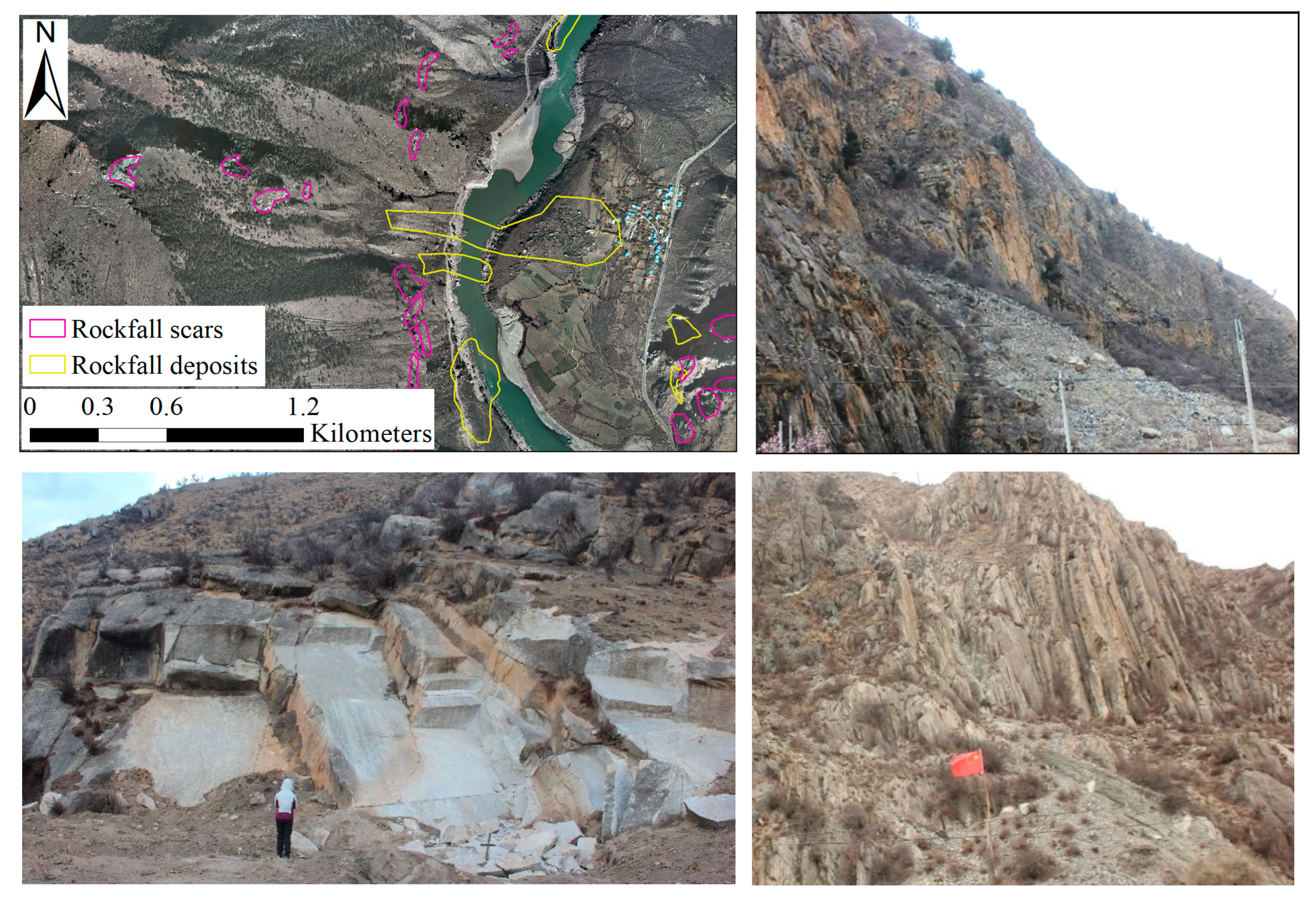
2.1. Study Area
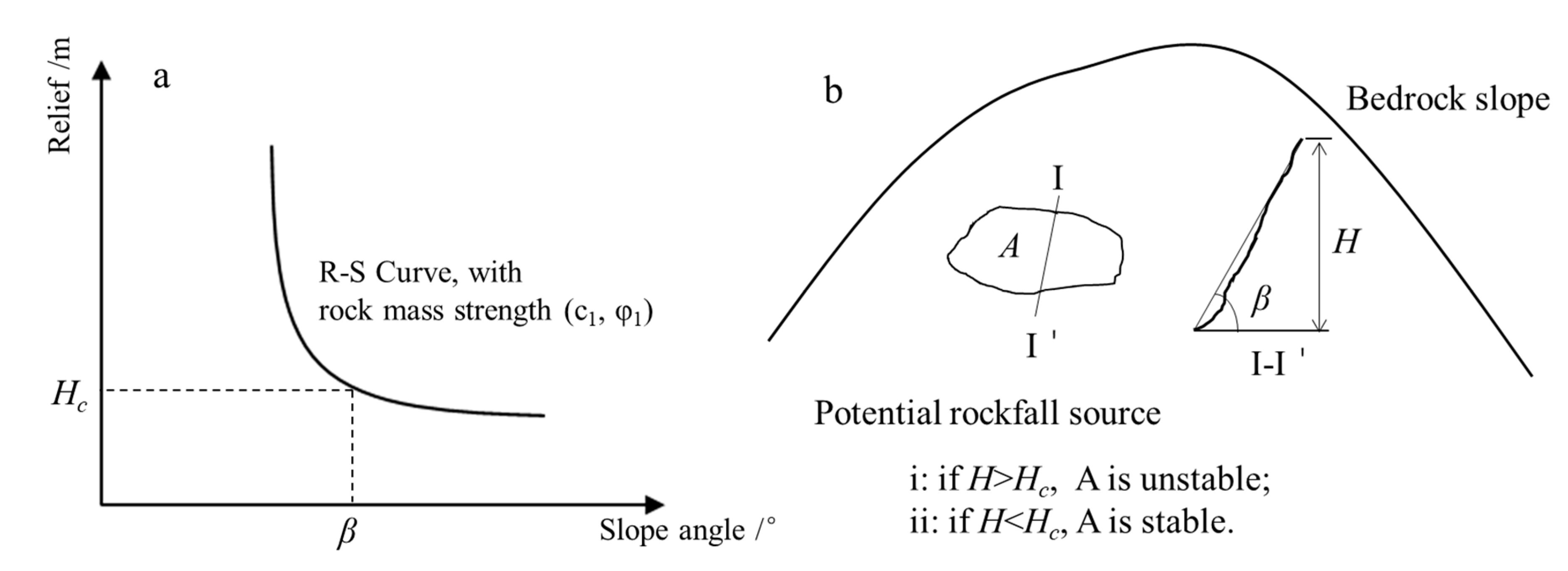
2.2. Framework of Identifying Potential Rockfall Source Areas
3. Results
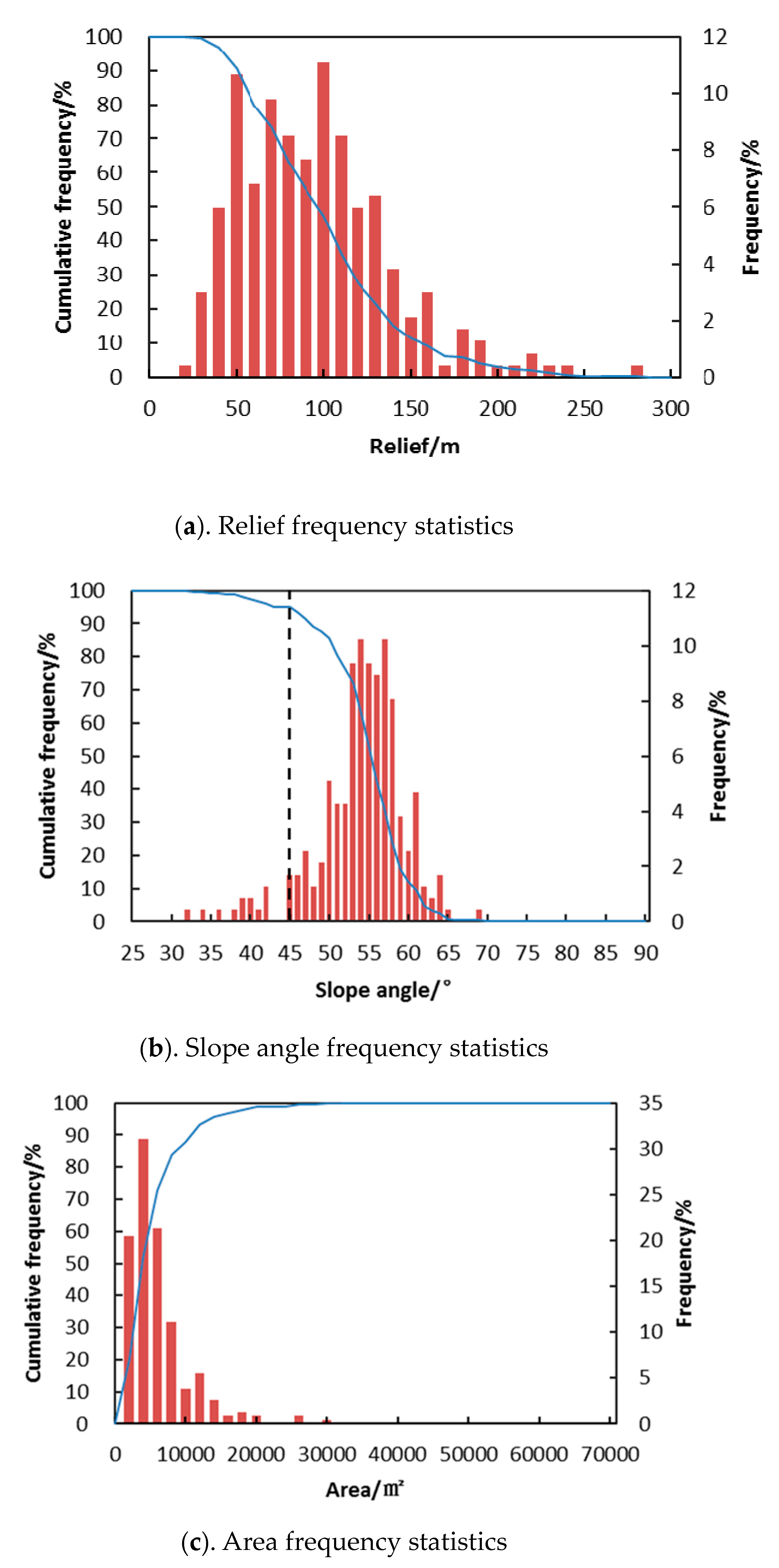
3.1. Geometrical Characteristics of Historical Rockfalls
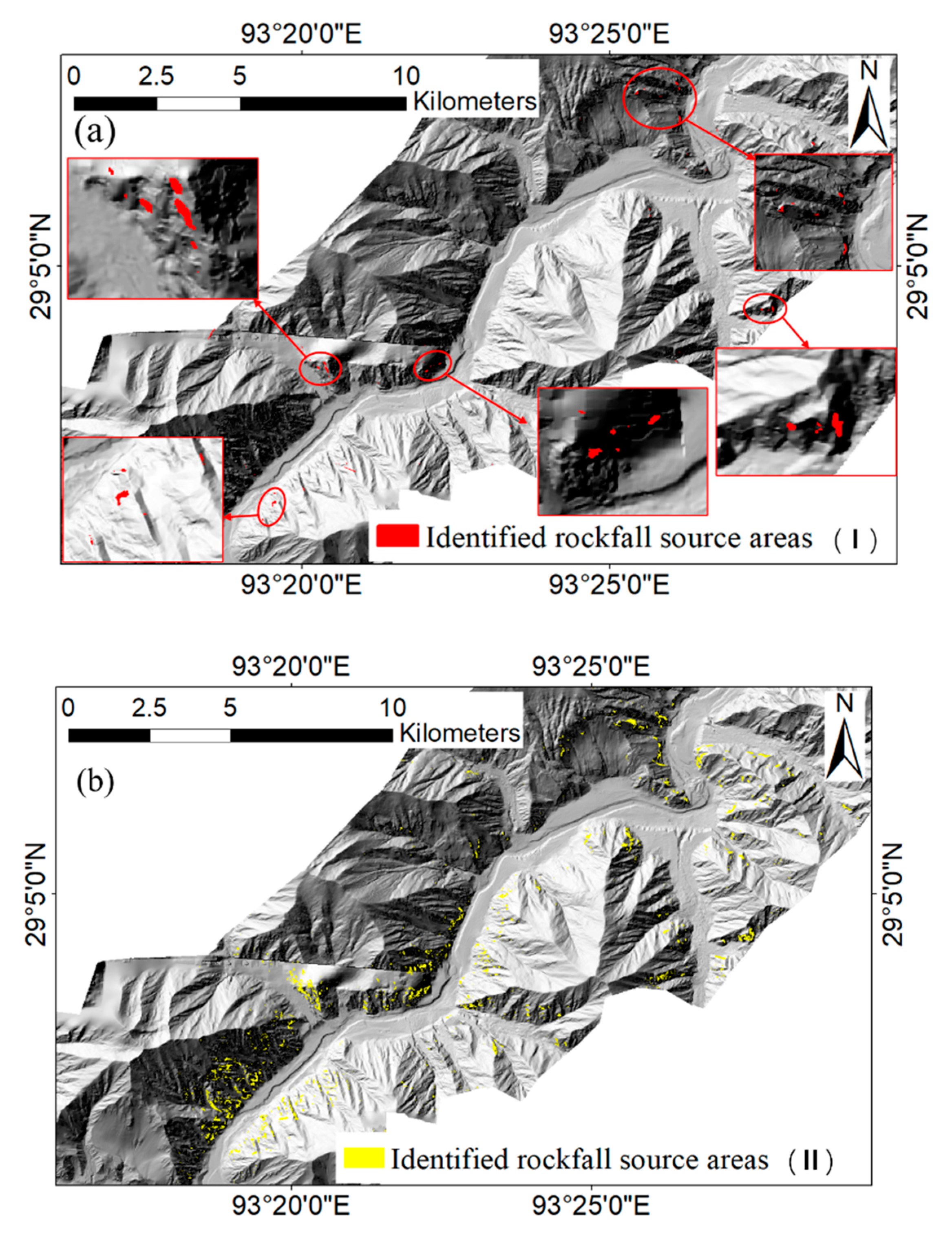
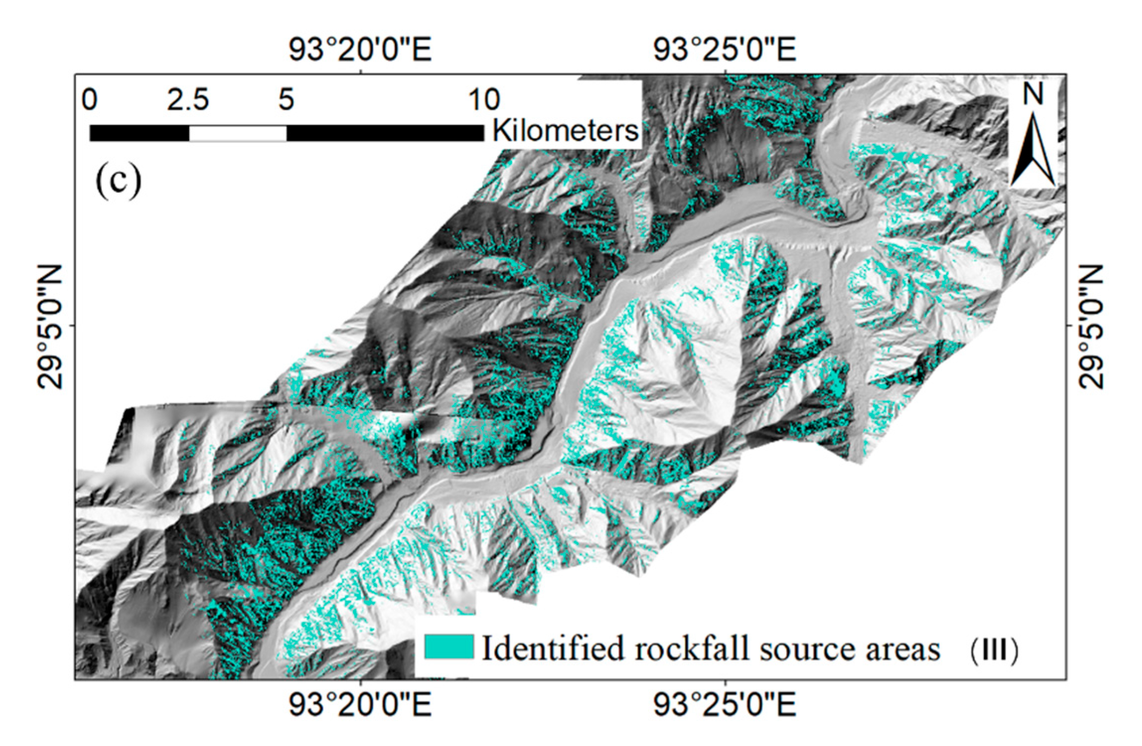
3.2. Locations of Identified Rockfall Sources
3.3. Zoning Map of Rockfall Susceptibility
4. Discussion
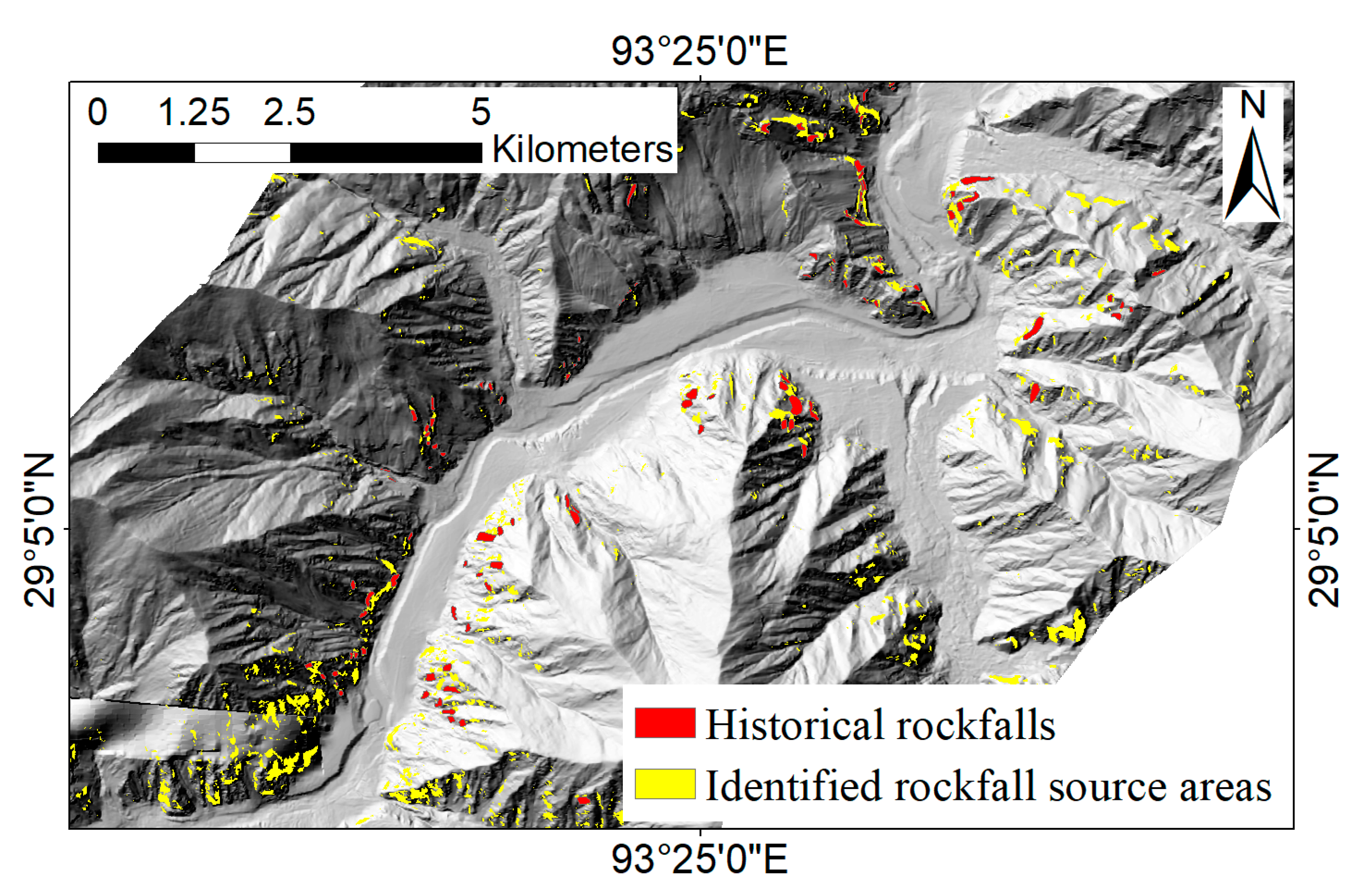
4.1. Validation
4.2. Uncertainty Analysis
5. Conclusions
Author Contributions
Funding
Acknowledgments
Conflicts of Interest
References
- Mazzoccola, D.F.; Hudson, J.A. A comprehensive method of rock mass characterization for indicating natural slope instability. Q. J. Eng. Geol. Hydrogeol. 1996, 29, 37–56. [Google Scholar] [CrossRef]
- Bunce, C.M.; Cruden, D.M.; Morgenstern, N.R. Assessment of the hazard from rock fall on a highway. Can. Geotech. J. 1997, 34, 344–356. [Google Scholar] [CrossRef]
- Guzzetti, F.; Carrara, A.; Cardinali, M.; Reichenbach, P. Landslide hazard evaluation: A review of current techniques and their application in a multi-scale study, Central Italy. Geomorphology 1999, 31, 181–216. [Google Scholar] [CrossRef]
- Gokceoglu, C.; Sonmez, H.; Ercanoglu, M. Discontinuity controlled probabilistic slope failure risk maps of the Altindag (settlement) region in Turkey. Eng. Geol. 2000, 55, 277–296. [Google Scholar] [CrossRef]
- Loye, A.; Jaboyedoff, M.; Pedrazzini, A. Identification of potential rockfall source areas at a regional scale using a DEM-based geomorphometric analysis. Nat. Hazards Earth Syst. Sci. 2009, 9, 1643–1653. [Google Scholar] [CrossRef]
- Liu, H.; Wang, X.; Liao, X.; Sun, J.; Zhang, S. Rockfall Investigation and Hazard Assessment from Nang County to Jiacha County in Tibet. Appl. Sci. 2019, 10, 247. [Google Scholar] [CrossRef] [Green Version]
- Wang, X.; Frattini, P.; Stead, D.; Sun, J.; Liu, H.; Valagussa, A.; Li, L. Dynamic rockfall risk analysis. Eng. Geol. 2020, 272, 105622. [Google Scholar] [CrossRef]
- Wang, X.; Zhang, L.; Wang, S.; Agliardi, F.; Frattini, P.; Crosta, G.B.; Yang, Z. Field investigation and rockfall hazard zonation at the Shijing Mountains Sutra caves cultural heritage (China). Environ. Earth Sci. 2011, 66, 1897–1908. [Google Scholar] [CrossRef]
- Stead, D.; Wolter, A. A critical review of rock slope failure mechanisms: The importance of structural geology. J. Struct. Geol. 2015, 74, 1–23. [Google Scholar] [CrossRef]
- Saroglou, C.; Qi, S.; Guo, S.; Wu, F. ARMR, a new classification system for the rating of anisotropic rock masses. Bull. Int. Assoc. Eng. Geol. 2019, 78, 3611–3626. [Google Scholar] [CrossRef]
- Jaboyedoff, M.; Metzger, R.; Oppikofer, T.; Couture, R.; Derron, M.H.; Locat, J.; Turmel, D. New insight techniques to analyze rock-slope relief using DEM and 3D-imaging cloud points: COLTOP 3D software. In Proceedings of the 1st Canada-US Rock mechanics Symposium, Vancouver, BC, Canada, 27–31 May 2007; pp. 27–31. [Google Scholar] [CrossRef]
- DiMatteo, L.; Romeo, S.; Kieffer, D.S. Rockfall analysis in Alpine area by using a reliable integrated monitoring system: Results from the Ingelsberg slope (Salzburg Land, Austria). Bull. Eng. Geol. Environ. 2017, 76, 413–420. [Google Scholar] [CrossRef]
- Mazzanti, P.; Schilirò, L.; Martino, S.; Antonielli, B.; Brizi, E.; Brunetti, A.; Margottini, C.; Mugnozza, G.S. The Contribution of Terrestrial Laser Scanning to the Analysis of Cliff Slope Stability in Sugano (Central Italy). Remote Sens. 2018, 10, 1475. [Google Scholar] [CrossRef] [Green Version]
- Kovanič, Ľ.; Blistan, P.; Urban, R.; Štroner, M.; Blišťanová, M.; Bartoš, K.; Pukanská, K. Analysis of the Suitability of High-Resolution DEM Obtained Using ALS and UAS (SfM) for the Identification of Changes and Monitoring the Development of Selected Geohazards in the Alpine Environment—A Case Study in High Tatras, Slovakia. Remote Sens. 2020, 12, 3901. [Google Scholar] [CrossRef]
- Cascini, L. Applicability of landslide susceptibility and hazard zoning at different scales. Eng. Geol. 2008, 102, 164–177. [Google Scholar] [CrossRef]
- Wang, X.L.; Zhang, L.Q.; Wang, S.J.; Lari, S. Regional landslide susceptibility zoning with considering the aggregation of landslide points and the weights of factors. Landslides 2014, 11, 399–409. [Google Scholar] [CrossRef]
- Budetta, P.; De Luca, C.; Nappi, M. Quantitative rockfall risk assessment for an important road by means of the rockfall risk management (RO.MA.) method. Bull. Int. Assoc. Eng. Geol. 2016, 75, 1377–1397. [Google Scholar] [CrossRef]
- Duarte, R.M.; Marquínez, J. The influence of environmental and lithologic factors on rockfall at a regional scale: An evaluation using GIS. Geomorphology 2002, 43, 117–136. [Google Scholar] [CrossRef]
- Frattini, P.; Crosta, G.; Carrara, A.; Agliardi, F. Assessment of rockfall susceptibility by integrating statistical and physically-based approaches. Geomorphology 2008, 94, 419–437. [Google Scholar] [CrossRef]
- Hoek, E. Strength of jointed rock masses. Géotechnique 1983, 33, 187–223. [Google Scholar] [CrossRef] [Green Version]
- Gudmundsson, A. Rock Fractures in Geological Processes; Cambridge University Press (CUP): Cambridge, UK, 2011. [Google Scholar]
- Francioni, M.; Antonaci, F.; Sciarra, N.; Robiati, C.; Coggan, J.; Stead, D.; Calamita, F. Application of Unmanned Aerial Vehicle Data and Discrete Fracture Network Models for Improved Rockfall Simulations. Remote Sens. 2020, 12, 2053. [Google Scholar] [CrossRef]
- Culmann, C. Die Graphische Statik; Meyer and Zeller: Zurich, Switzerland, 1875; 644p. [Google Scholar]
- Schmidt, K.M.; Montgomery, D.R. Limits to Relief. Science 1995, 270, 617–620. [Google Scholar] [CrossRef]
- Montgomery, D.R.; Brandon, M.T. Topographic controls on erosion rates in tectonically active mountain ranges. Earth Planet. Sci. Lett. 2002, 201, 481–489. [Google Scholar] [CrossRef]
- Crosta, G.B.; Utili, S.; De Blasio, F.V.; Castellanza, R. Reassessing rock mass properties and slope instability triggering conditions in Valles Marineris, Mars. Earth Planet. Sci. Lett. 2014, 388, 329–342. [Google Scholar] [CrossRef]
- DiBiase, R.A.; Rossi, M.W.; Neely, A.B. Fracture density and grain size controls on the relief structure of bedrock landscapes. Geology 2018, 46, 399–402. [Google Scholar] [CrossRef] [Green Version]
- Crosta, G.B.; Agliardi, F. A methodology for physically based rockfall hazard assessment. Nat. Hazards Earth Syst. Sci. 2003, 3, 407–422. [Google Scholar] [CrossRef]
- Quidelleur, X.; Grove, M.; Lovera, O.M.; Harrison, T.M.; Yin, A.; Ryerson, F.J. Thermal evolution and slip history of the Renbu Zedong Thrust, southeastern Tibet. J. Geophys. Res. Space Phys. 1997, 102, 2659–2679. [Google Scholar] [CrossRef]
- Xu, Z.-Q.; Dilek, Y.; Yang, J.-S.; Liang, F.-H.; Liu, F.; Ba, D.-Z.; Cai, Z.-H.; Li, G.-W.; Dong, H.-W.; Ji, S.-C. Crustal structure of the Indus–Tsangpo suture zone and its ophiolites in southern Tibet. Gondwana Res. 2015, 27, 507–524. [Google Scholar] [CrossRef]
- Burbank, D.W.; Leland, J.; Fielding, E.; Anderson, R.S.; Brozovic, N.; Reid, M.R.; Duncan, C. Bedrock incision, rock uplift and threshold hillslopes in the northwestern Himalayas. Nat. Cell Biol. 1996, 379, 505–510. [Google Scholar] [CrossRef]
- Finnegan, N.J.; Hallet, B.; Montgomery, D.R.; Zeitler, P.K.; Stone, J.O.; Anders, A.M.; Liu, Y.P. Coupling of rock uplift and river incision in the Namche Barwa–Gyala Peri massif, Tibet. Geol. Soc. Am. Bull. 2008, 120, 142–155. [Google Scholar] [CrossRef]
- Fell, R.; Cororninas, J.; Bonnard, C.; Cascini, L.; Leroi, E.; Savage, W.Z. Guidelines for landslide susceptibility, hazard and risk-zoning for land use planning. Eng. Geol. 2008, 102, 85–98. [Google Scholar] [CrossRef] [Green Version]
- Ayalew, L.; Yamagishi, H.; Maruib, H.; Kannoc, T. Landslides in Sado Island of Japan: Part II. GIS-based susceptibility mapping with comparisons of results from two methods and verifications. Eng. Geol. 2005, 81, 432–445. [Google Scholar] [CrossRef]
- Chung, C.F.; Fabbri, A.G. Validation of spatial prediction models for landslide hazard mapping. Nat. Hazard. 2003, 30, 451–472. [Google Scholar] [CrossRef]



| Slope Angle (°) | Limit Relief (m) | Slope Angle (°) | Limit Relief (m) | Slope Angle (°) | Limit Relief (m) | ||||||
|---|---|---|---|---|---|---|---|---|---|---|---|
| C-U | C-M | C-L | C-U | C-M | C-L | C-U | C-M | C-L | |||
| 46.0 | 35.5 | 189.1 | 342.7 | 61.0 | 16.2 | 86.2 | 156.2 | 76.0 | 9.6 | 50.9 | 92.3 |
| 47.0 | 33.2 | 176.7 | 320.3 | 62.0 | 15.6 | 82.8 | 150.0 | 77.0 | 9.3 | 49.4 | 89.5 |
| 48.0 | 31.2 | 165.8 | 300.4 | 63.0 | 15.0 | 79.6 | 144.2 | 78.0 | 9.0 | 47.9 | 86.9 |
| 49.0 | 29.3 | 155.8 | 282.4 | 64.0 | 14.4 | 76.6 | 138.8 | 79.0 | 8.7 | 46.5 | 84.3 |
| 50.0 | 27.6 | 146.9 | 266.1 | 65.0 | 13.9 | 73.7 | 133.6 | 80.0 | 8.5 | 45.2 | 81.9 |
| 51.0 | 26.1 | 138.7 | 251.4 | 66.0 | 13.4 | 71.1 | 128.8 | 81.0 | 8.3 | 43.9 | 79.6 |
| 52.0 | 24.7 | 131.3 | 238.0 | 67.0 | 12.9 | 68.5 | 124.2 | 82.0 | 8.0 | 42.7 | 77.3 |
| 53.0 | 23.4 | 124.6 | 225.7 | 68.0 | 12.4 | 66.2 | 119.9 | 83.0 | 7.8 | 41.5 | 75.2 |
| 54.0 | 22.2 | 118.4 | 214.5 | 69.0 | 12.0 | 63.9 | 115.8 | 84.0 | 7.6 | 40.3 | 73.1 |
| 55.0 | 21.2 | 112.7 | 204.1 | 70.0 | 11.6 | 61.8 | 111.9 | 85.0 | 7.4 | 39.2 | 71.1 |
| 56.0 | 20.2 | 107.4 | 194.6 | 71.0 | 11.2 | 59.7 | 108.2 | 86.0 | 7.2 | 38.2 | 69.2 |
| 57.0 | 19.3 | 102.5 | 185.8 | 72.0 | 10.9 | 57.8 | 104.7 | 87.0 | 7.0 | 37.2 | 67.3 |
| 58.0 | 18.4 | 98.0 | 177.6 | 73.0 | 10.5 | 55.9 | 101.4 | 88.0 | 6.8 | 36.2 | 65.5 |
| 59.0 | 17.6 | 93.8 | 170.0 | 74.0 | 10.2 | 54.2 | 98.2 | 89.0 | 6.6 | 35.2 | 63.8 |
| 60.0 | 16.9 | 89.9 | 162.9 | 75.0 | 9.9 | 52.5 | 95.2 | 90.0 | 6.5 | 34.3 | 62.2 |
Publisher’s Note: MDPI stays neutral with regard to jurisdictional claims in published maps and institutional affiliations. |
© 2021 by the authors. Licensee MDPI, Basel, Switzerland. This article is an open access article distributed under the terms and conditions of the Creative Commons Attribution (CC BY) license (http://creativecommons.org/licenses/by/4.0/).
Share and Cite
Wang, X.; Liu, H.; Sun, J. A New Approach for Identification of Potential Rockfall Source Areas Controlled by Rock Mass Strength at a Regional Scale. Remote Sens. 2021, 13, 938. https://doi.org/10.3390/rs13050938
Wang X, Liu H, Sun J. A New Approach for Identification of Potential Rockfall Source Areas Controlled by Rock Mass Strength at a Regional Scale. Remote Sensing. 2021; 13(5):938. https://doi.org/10.3390/rs13050938
Chicago/Turabian StyleWang, Xueliang, Haiyang Liu, and Juanjuan Sun. 2021. "A New Approach for Identification of Potential Rockfall Source Areas Controlled by Rock Mass Strength at a Regional Scale" Remote Sensing 13, no. 5: 938. https://doi.org/10.3390/rs13050938
APA StyleWang, X., Liu, H., & Sun, J. (2021). A New Approach for Identification of Potential Rockfall Source Areas Controlled by Rock Mass Strength at a Regional Scale. Remote Sensing, 13(5), 938. https://doi.org/10.3390/rs13050938


