Article

Testing and Validating the Suitability of Geospatially Informed Proxies on Land Tenure in North Korea for Korean (Re-)Unification

Chair of Land Management, TUM School of Engineering & Design, Technical University of Munich (TUM), Arcisstrasse 21, 80333 Munich, Germany
*
Author to whom correspondence should be addressed.
Remote Sens. 2021, 13(7), 1301; https://doi.org/10.3390/rs13071301
Submission received: 18 February 2021 / Revised: 24 March 2021 / Accepted: 26 March 2021 / Published: 29 March 2021
(This article belongs to the Special Issue Remote Sensing for Land Administration 2.0)

Abstract

:
The role of remote sensing data in detecting, estimating, and monitoring socioeconomic status (SES) such as quality of life dimensions and sustainable development prospects has received increased attention. Geospatial data has emerged as powerful source of information for enabling both socio-technical assessment and socio-legal analysis in land administration domain. In the context of Korean (re-)unification, there is a notable paucity of evidence how to identify unknowns in North Korea. The main challenge is the lack of complete and adequate information when it comes to clarifying unknown land tenure relations and land governance arrangements. Deriving informative land tenure relations from geospatial data in line with socio-economic land attributes is currently the most innovative approach. In-close and in-depth investigations of validating the suitability of a set of geospatially informed proxies combining multiple values were taken into consideration, as were the forms of knowledge co-production. Thus, the primary aim is to provide empirical evidence of whether proposed proxies are scientifically valid, policy-relevant, and socially robust. We revealed differences in the distributions of agreements relating to land ownership and land transfer rights identification among scientists, bureaucrats, and stakeholders. Moreover, we were able to measure intrinsic, contextual, representational, and accessibility attributes of information quality regarding the associations between earth observation (EO) data and land tenure relations in North Korea from a number of different viewpoints. This paper offers valuable insights into new techniques for validating suitability of EO data proxies in the land administration domain off the reliance on conventional practices formed and customized to the specific artefacts and guidelines of the remote sensing community.

Graphical Abstract

1. Introduction

The role of remote sensing data in detecting, estimating, and monitoring socioeconomic status (SES) such as quality of life dimensions and sustainable development prospects has received increased attention across number of disciplines in recent years [1,2,3,4,5]. Geospatial thinking and technology have provided an important opportunity to advance the understanding of the specific questions which drives SES perspectives that include humanitarian health [6,7], rural household poverty [4,8], neighborhood deprivation [9], valuation of land and property [10], and urban dynamics [3]. This argument has given rise to much debate on not only making an association of remotely sensed spatial data and socio-economic parameters but also predicting or interpreting them.
Land administration deals with the people-to-land relationship, by describing, analyzing, designing, and measuring their relations that include social, economic, spatial, legal, and engineering perspectives [11]. Along with the growth of remote sensing applications in SES, there has been growing recognition and evidence of the vital links between remote sensing and land administration [12,13,14,15,16,17,18,19]. Geospatial data has emerged as powerful source of information for enabling both socio-technical assessment [20] and socio-legal analysis [21] in land administration sphere. Moreover, recent advancements have led to a renewed interest in identifying socio-spatial footprints of land boundaries and associated land rights through integration of different sets of geospatial and socio-economic data and informative interpretation [12,21]. Thus, a novel approach to land administration sheds a contemporary light on grounded theories and practices of land tenure, use, value, development, and governance.
However, the challenge now is how to make better use of geospatial technologies to generate evidence and the resulting data as robust evidence in spatial decision-making processes. Although, the effectiveness of the earth observation (EO) data for public decision-making in the land sector has been well-exemplified by [22,23], it was also claimed that the existing accounts fail to fully resolve the government demands for better land policy-making and planning [22]. This argument is line with a longstanding quarrel of evidence-informed policy-making [24,25,26,27] that aims to ensure transparent use of sound evidence and appropriate consultation processes in policy making [24]. It is therefore that such evidence must meet certain criteria on technical quality, a relevant source of information and effective communication [28]. The term "geospatially informed analysis (GIA)" is used here to refer to evidence generation and provision of salient and legitimate evidence in spatial decision-making, supported by geospatial technologies and geospatial data. With regard to land management, it is important to bear in mind that spatial decision making is conducted on various spatial scales, ranging from local to national, and thus incorporates multiple spatial cognitions and perspectives of both state and non-state agencies.
It is possible that GIA might not be applicable to the contexts in which the limited access to data exists, quality of data matters and reliability of data sources have been raised. North Korea belongs to this category. Studies on North Korea [29,30,31,32,33,34] and governing North Korean land tenure [35,36,37,38] have attracted considerable attention, both scholarly and popular. The majority of existing research accounts for land (tenure) reform in North Korea and land governance arrangements in unified Koreas. To date, however, there is a notable paucity of evidence-based literature describing and investigating how to identify unknown land tenure relations in North Korea due to the obvious difficulties in obtaining and analyzing empirical data. Several ways of overcoming these barriers to capturing the relationship between land tenure and governance and Korean (re-)unification process have recently been suggested that involve understanding and suggesting methods and solutions to problems [21,39,40]. Drawing upon both land administrative and geospatial engineering approaches, these enabled to provide reasonably consistent evidence and knowledge-base of an association between land tenure/land governance and (re-)unification of which relatively little is known. Whereas previous approaches suggested here were based on documented spatial knowledge and reasoning relating to land tenure and land governance, this study aims to supplement and extend these insights by incorporating and reflecting on local spatial knowledge and expertise.
Although a number of different studies have been conducted on the subject of North Korea and its refugees, there are still insufficient insights into the fundamental differences between North Korean and South Korean perceptions, beliefs, and experiences [41]. Such an information gap may hamper a smooth transition towards unification. It is therefore of fundamental importance to gain further insights directly from North Korean refugees. Currently, the only possible way of doing this is to interview and engage with North Korean refugees (that refers to new settlers or defectors; saeteomin or bukhanitaljumin in Korean terms). Urban studies in North Korea tend to involve on-site work, social contact, and face-to-face interaction with the population of interest rather than relying on existing literature and available data. However, most of the work carried out to date has not been able to provide robust evidence on the basis of persistent observation and in-depth analysis [42].
In general, gathering information regarding land tenure from multiple non-human resources such as legislation, policy documents and case studies is possible. However, the main challenge faced by many decision-makers is the incompleteness and inadequacy (inadequate proof or evidence) of information when it comes to clarifying how land tenure relations and land governance arrangements are really constructed and maintained in North Korea. In the light of these unknowns, additional data from multiple stakeholders is valuable for obtaining a more detailed insight into the broad spectrum of personal experience, views, and judgements [43,44]. In this respect, North Korean refugees can also act as human capital, not only as a supplement to publications on North Korea but also as a way of conducting an empirical analysis of primary data on North Korea [45].
When it comes to abnormal circumstances for gathering empirical evidence in this study, it is necessary to explain the main challenges and most common practices. More recent attention in urban planning and land management of North Korea has focused on using focus group interview (FGI) methods with North Korean refugees and spatial analysis with Google Earth images (EO data). Notwithstanding the fact that these methods seem to be most feasible and effective, the current research on land tenure and land governance in North Korea has been impeded by the lack of empirical data, rigorous methodologies, and reliability and validity of information for the in-close and in-depth investigation. Therefore, in addition to methods commonly used, such a content analysis on internal documents in North Korea and joint expert consultation processes make up for a dearth of evidence-based knowledge base [42,46].
Adopting a similar position aforementioned, findings from a previous study demonstrate how a process of socializing the pixel (combining with land administrative and geospatial engineering approaches) can take place through (re-)interpreted semantic land tenure relations [21]. As a result, GIA has been proposed based on a mixed-methods design and an information fusion approach, to construct a strong and consistent association between land tenure and EO data. However, a further investigation into the validation of elaborated meaning and interpreted information throughout extensive consultations with outside experts and multiple stakeholders needs to be undertaken before the association between land tenure and EO data can be more clearly understood in line with algorithmic approaches. Thus, the primary aim of this paper is to provide empirical evidence for the claim that it is possible to standardize the identification and categorization of certain objects, environments, and semantics visible in EO data that can be used to (re-)interpret land tenure relations.
Given our awareness of critical consequences in misidentifying geospatially informed proxies due to the lack of appropriate and rigorous validation of suitability, a threefold approach to empirical knowledge elicitation for GIA is taken, comprising (1) extracting scientific knowledge with a high-level of expertise based on topical (i.e., land tenure and land administration), methodological (i.e., remote sensing and earth observation), and contextual (i.e., Korean (re-)unification) interests; and (2) identifying bureaucratic knowledge (i.e., government officials); and (3) deriving knowledge of local communities in geographic areas of interest from people (i.e., North Korean refugees) who have the most accurate understanding (through familiarity or personal experience) of land tenure relations, land governance and land use practices. This study seeks to answer the following specific research questions:
  • To what extent does scientific, bureaucratic and stakeholder knowledge agree or disagree with a set of identified pixel-based proxies related to land tenure in North Korea?
  • How does a knowledge co-production process help to validate suitability of geospatially informed proxies and become legitimate land tenure knowledge?
This paper comprises four sections. The first deals with the conceptual and methodological accounts of research and analysis. The following section brings together the key findings relating to proxy identification and the measurement of information quality. The remaining sections of the paper comprises a summary and discussion of the findings and further implications for future research, respectively.

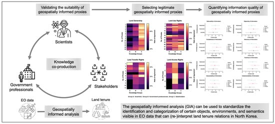
2. Validating the Suitability of Geospatially Informed Proxies

Validating the suitability of the remote sensing data and products against the social context of the location is critical. However, despite the explosive growth in the use of remote sensing in a wide range of applications in many different fields, there is increasing concern about the lack of rigorous social and contextual validation methods and techniques, which, in turn, may result in the misidentification or misinterpretation of proxies. Therefore, to ensure better-informed geospatial analysis, it is necessary to consider not only the procedure and legitimacy of validating the suitability of relevant proxies and combining multiple values through knowledge co-production processes.

2.1. On the Need of Tailored Approaches to EO Data Validation

"Validation" is a term frequently used in the remote sensing literature, yet it is used in different disciplines to mean different things. To avoid, terminological confusion, it is important to bear in mind that the term validation throughout this paper has come to be used in its broadest sense to refer to validating suitability or usability of proxies using EO data for GIA. A validation is a fundamental requirement when using EO data in any mapping project. It provides a basis for identifying classification errors and enables the overall accuracy and uncertainty of mapping outcomes to be estimated with sample data [47]. Congalton [48] lists three reasons why validation has become so important. It enables (1) the identification and correction of usage errors in images, (2) a robust quantitative comparison of methods, and (3) the provision of more reliable information to enable better informed decision making. Much of the available literature on remote sensing deals with the question of accuracy; however, Campbell and Wynne [49] critically warn that validation is a much more complex process, as considered by many, and it displays obvious difficulties in convincingly addressing whether the outcomes are correct. The design of sampling, response, and analysis processes are an important component of accuracy assessment and play a key role in yielding rigorously defensible validation in remote sensing science [47]. As conventional methods, there are several possible validation techniques available to examine the accuracy or error of EO data, such as visual inspection, non-site-specific analysis, difference image creation, error budgeting and quantitative accuracy assessment [48,49]. Indeed, the renewed interest in various image classification methods, such as geographic object-based image analysis (GEOBIA), necessitates a range of different validation efforts to meet the respective characteristics [50].
Despite the cutting-edge advancements in EO data validation, it should be noted that remote sensors on satellites and aircraft cannot directly detect and record a particular social, political, economic, or historical context of landscapes and their internal dynamics [51]. Unlike the remote sensing community, some studies confirmed that including participatory techniques with professionals in land administration domain helps to validate quality and usability [52,53]. Moreover, a qualitative approach in conjunction with visual interpretation and quantitative analysis to measure the scalability of the semi-automated cadastral boundary feature extraction from remote sensing data has been applied to the validation [54]. In the same vein, using EO data to derive proxies for identifying and interpreting unknown land tenure relations requires a rigorous interpretation of various contextual information and a more nuanced insight into the socio-legal-spatial properties. Therefore, there are limits to how far conventional and solid validation procedures, which have already been formed and customized for specific artefacts and validation objectives in the remote sensing community [55], can be taken in land administration science. In other words, a tailored validation protocol would help to establish a higher accuracy and feasibility based on the results obtained from the EO data interpretation.

2.2. Knowledge Co-Production: Scientific, Bureaucratic and Stakeholder Knowledge

The notion of "knowledge co-production" is commonly used to refer to the collaborative and interactive process of synthesizing different sources and types of knowledge [56,57,58]. Co-produced knowledge blurs the boundaries between science and practice [59]. Therefore, not only experts, scientists and professionals now play a pivotal role in the decision-making process, but the committed knowledge of non-scientific stakeholders should also be taken into account.
According to Freedman [60], if scientifically valid trials of a useful or interesting hypothesis are conducted or provide reliable information on the hypothesis being tested, the values and validity are recognized as scientific. To enable this, scientific validation needs to consider the inclusion of expert knowledge at higher levels of education and professionalism in order to test for scientific acceptability such as transparency and replicability of results [61]. Bureaucratic knowledge is now considered essential, as bureaucrats and civil servants possess advanced knowledge from governance processes that include top-down political representation, bottom-up citizen participation and informal knowledge-sharing networks [62]. In administrative and government practice, "bureaucratic knowledge" serves to navigate complex decision making. It associates the political and strategic use of knowledge rather than the intrinsic (non-instrumental) value of knowledge, such as the norms of ethos and ethics, with bureaucratic works [57,62,63,64]. Thus, bureaucratic validation is such that it synthesizes knowledge from both internal and external resources and creates new forms of knowledge from perceptions of political feasibility and institutional arrangement [65]. Unlike scientific validation, which is based on replication logic, bureaucratic knowledge relies on either pragmatic plausibility or feasibility logic, similar to political logic.
However, critical questions have been raised about the uncertainty of decision making in resolving multifaceted local and societal problems on the sole basis of scientific and expert knowledge [66]. One of the most significant current discussions in this argument concerns the incorporation of varying stakeholder knowledge that reduces rigidity, represents multiple perspectives, and promotes adaptability in decision making [67]. There is also a growing body of literature that recognizes the importance of stakeholder or lay knowledge as a key informant that emphasizes intense contextual and localized knowledge of people in their local environments [68]. Therefore, the potential advantage of using stakeholder validation is the increased precision both in terms of context and localization in validating the suitability of proxies that cannot be verified through disciplinary expert assessment or administrative capacity. In view of all that has been mentioned so far, one may suppose, as argued by Edelenbos et al., [57] that only coproduced knowledge fully assesses pre-identified proxies for GIA that considers scientific validity, policy relevance and social robustness.

2.3. Geospatially Informed Analysis (GIA)

In recent decades, describing, analyzing, and understanding people-to-land relations using geospatial technology has given rise to effective legal, social, and spatial solutions to multifaceted problems relating to land. Recently, more advanced geospatial intelligence has not only offered administratively straightforward, technically feasible, and financially affordable approaches [69], but it has also provided a rich set of data and information that conventional analytical techniques would have been unable to identify or access. We also view land management as a combination of interventions in governance, based on questions of how and under what conditions such land interventions are responsible and how these can be supported by technologies. It is possible, therefore, that GIA supports both smart and responsible land management [70,71], especially of difficult-to-access regions where unknown or unsupported land governance exists [21,39,40].
On the one hand, geospatial intelligence is not currently sufficiently embedded in decision-making processes, while on the other, decision makers do not sufficiently rely on geospatial intelligence, even though it is available. Even geospatial intelligence is too product-oriented and insufficiently process-oriented. Based on this line of argument, we note that, despite the above claims of GIA, it still needs to be clarified how, where, and when it can be used to enrich both scientific and bureaucratic knowledge. Building on the critical insights from GIA, it enables us to address proxy development in a smart and responsible manner, where significant uncertainty exists regarding data access, data integration and data reliability.
GIA is fast becoming the ultimate driver of spatial decision making in land management and sheds new light on recent insights into societies, the environment, the earth, resilience, and sustainable development. However, scientifically framed knowledge and technical expertise in remote sensing and earth observation tends to greatly exaggerate the excellence of laboratory experiments conducted under highly controlled conditions and technocratic approaches to dealing with land/spatial problems. At the same time, the dominance of bureaucratic knowledge in land policymaking devalues other forms of knowledge and undermines the local context, the political representation of citizens and the social processes of land governance and land use. Using geospatial tools and instruments, the citizen (stakeholder) is now able not only to consume and produce geospatial information but also to contribute grounded knowledge more effectively to spatial decision-making processes. Synchronization, complementing and contradiction with views, judgements and experiences in the knowledge coproduction process affect the GIA utilized in spatial decision making and thus determine exactly how, where and when different forms of knowledge can legitimize scientific standards and conformity as bureaucratic and social norms.

3. A Case Study: Geospatially Informed Analysis of North Korea

The method was designed for which proxies are considered relevant and useful by scientists, government professionals and stakeholders and to elicit their evaluation of the information quality. This necessitated very careful investigation. A survey was conducted with 77 sample respondents recruited from scientific, bureaucratic and stakeholder groups. Data for this study were collected using a web-based questionnaire, and the analysis used both the Chi-square test and the one-way ANOVA test. The following subsections describe in greater detail what was investigated and who was involved, how the survey was conducted and how the data was analyzed.

3.1. Identification of Proxies and Quality of Information

The first important stage of the analysis was to identify proxies by which to derive unknown land tenure relations in North Korea in conjunction with EO data. A preliminary investigation proposed a set of candidate proxies relating to the key questions based on the elements of image interpretation used in remote sensing, divided into the four categories of land ownership, land use, land transfer, and land access [21]. Within these categories, a total of 66 proxies were derived from 32 groups of objects, environments and semantics that were visible in the EO data and that could be (re-)interpreted to discern unknown land tenure relations in North Korea (see Figure 1). These proxies generally consisted of combinations of shape patterns, colors, textures relating to physical structures, types of buildings, infrastructures, types of land use, and proximity of comparable features. The line of reasoning attached to the proxies is significantly associated with central concepts of tenure claims and interests such as collective ownership, land lease and use, occupation, transactions, and land access. Hence, in line with our approach to validating the suitability of remotely sensed proxies, we set out to test the hypothesis that determines “whether proposed proxies are (1) scientifically valid, (2) administratively relevant or useful, and (3) contextualized and localized.” Hence, the null hypothesis (H0) is “no difference between scientific, bureaucratic, and stakeholder distributions (of agreements) for identified proxies.”
One of the most influential accounts of a methodology for information quality assessment comes from [72], which sets out the theoretical dimensions of information quality (IQ) and comprehensively examines four key quality attributes from both academics’ and practitioners’ perspectives: (1) intrinsic, (2) contextual, (3) representational, and (4) accessible. Both intrinsic and contextual quality underline the informative factors, but intrinsic attributes are associated with accuracy, believability, reputation, and objectivity, whereas the latter considers tasks that require added value, relevance, completeness, timeliness, and an appropriate amount. On the other hand, both representational and accessibility dimensions stress the technical accounts of the system by which information must not only be interpretable, easy to understand and represented clearly and consistently, but also emphasize accessibility and security [72]. To test the hypothesis, two different approaches were taken in an attempt to account for the identification of proxies (Part I of the questionnaire) and the measurement of information (proxy) quality (Part II of the questionnaire).

3.2. Selection of Proxies and Measurement of Information Quality

3.2.1. Participants

The participants (see Table 1) were divided into three groups on the basis of their knowledge production methods: (1) scientific knowledge, focusing in particular on topical, methodological, and contextual interests (scientists); (2) bureaucratic knowledge that exists in the context of administrative and governmental practices; and (3) stakeholder knowledge of key informants with the emphasis on contextual and localized knowledge of North Korea. A random sample of participants (i.e., thus, it is unable to report the participation rate exactly.) with a different set of knowledge was identified from personal networks and connections with government agencies (from Korea Land and the Geospatial Informatix Corporation (LX) as well as local authorities under the Ministry of Land, Infrastructure and Transport (MOLIT)), (non-)governmental organizations (the Korea Hana Foundation, the Together Foundation, and the Saeil Academy), academic and research institutions (from universities, the Korea Research Institute for Human Settlements (KRIHS), the Land & Housing Institute (LHI), and the Spatial Information Research Institute (SIRI)) in South Korea. Therefore, group A and B were recruited based on South Korean’s expertise, while group C consisted of North Korean refugees living in South Korea.
A total of 77 participants took part in the study. Of the total cohort of 77 participants, 29 were members of scientific knowledge groups (38%) while 30 and 18 respondents were from bureaucratic (39%) and stakeholder knowledge groups (23%), respectively (see Table 1). The Participants A group comprised scientists representing a broad range of expertise and domains in the fields of land management, land administration, land governance, land tenure, and cadastral surveying. This group also included eligible specialists with substantial knowledge and skills in remote sensing and earth observation technologies. In addition, participants were recruited from independent entities who share knowledge and a deeper understanding of Korean (re-)unification. The Participant B group represented bureaucratic knowledge and policy usefulness, with the following parameters: government professionals and officials who demonstrated a set of professional skills and had gained relevant work experience in public sectors involving land tenure/administration/management, land/cadastral surveying, and geospatial information. To create our stakeholder sample, we considered people with a declared or conceivable interest or stake in land tenure relations, land governance arrangements and land-use practices in North Korea. Thus, the Participants C group involves judgements of stakeholders who have the most direct and accurate understanding of land systems in North Korea by virtue of their life experience; in our context, this refers to North Korean refugees.
To begin this process, each participant group was invited via multiple contact points to participate in the study, with a link to the online questionnaire included. The participants were asked to complete two tasks relating to the identification of proxies and the measurement of information quality. The invitations included a clear explanation of the purpose of the research, along with an introductory statement and instructions attached to the questionnaire. Originally, the questionnaire was compiled in English. However, it was subsequently translated into Korean to gain a better understanding of the possibilities of identifying proxies and measuring information quality. The participants were asked to complete two parts of the anonymized questionnaire within two weeks (29 June–15 July 2020).

3.2.2. Questionnaire

The questionnaire was developed in consultation and discussion with international and local scientific communities (e.g., universities and research institutions), (1) by sharing cutting-edge scientific knowledge on smart and responsible land management; (2) by comparing how local contexts influence land tenure relations, especially in developing countries; and (3) by underpinning a new conceptual and methodological account of a geospatially informed analysis in a remote sensing community.
Due to budget constraints, time-limitations, and travel restrictions (owing to COVID-19), the data was collected using a web-based questionnaire based on the freely available Google Forms questionnaire. In order to identify the most transferrable and applicable proxies, the participants were asked whether they agreed or disagreed by choosing one of two possible values on a binary scale. One advantage of the binary scale is that it avoids the problem of nuanced and neutral answers from respondents. By forcing respondents’ options, we obtained precise data with which to clarify and confirm the proxies identified beforehand (See Figure 1). In addition, after each proxy group category, participants were able to add their comments or suggestions for additional candidate proxies in a supplementary space (see further details of a questionnaire with a following link: https://forms.gle/8SzK323vYWBhRfhF8; it is available only in Korean.). To provide a good and full understanding of the questionnaire’s survey content, the questionnaire was fully described with the background, purpose, and key terms of study, and provided sample satellite images in each section with detailed descriptions. We also amended the question format into a more respondents-friendly form with the help of a communication expert as well as many land administration specialists in South Korea to make it easier for respondents to answer the questions.
Unlike the binary scale format, Likert items allow more finely tuned responses and enable respondents to indicate the extent of their agreement, including a neutral response to the questions. For the attitude questions measuring information quality, a 5-point Likert scale was used to ask respondents whether they agreed or disagreed, with the following possible variations: excellent, good, fair, poor, very poor. Questions on measurement were in part adopted from AIMQ (a methodology for information quality assessment) methodology [67] and referred to such as aspects as believability, completeness, consistent representation, interpretability, objectivity, relevancy, timeliness, and understandability. Finally, the participants were asked to leave an e-mail address if they wished to know the results of the study.

3.2.3. Data Analysis

To formally compare the views and judgements of different group samples in identifying geospatially informed proxies, the Chi-square test was selected to test whether there were any (significant) differences in the distributions across scientific experts, bureaucrats, and stakeholders. We adopted the Chi-square test since this test is also suitable for more than two nominal variables or arbitrary dimension (R × C rather than 2 × 2) [73,74]. Proxies representing only a few statistical differences (p < 0.05) were considered to be in agreement. The experiment was conducted with two possible outcomes (agree or disagree) with the results of the proxy identification (validation) being expressed as a proportion of the overall respondents from the scientific, bureaucratic and stakeholder groups, since our data were derived from random sampling.
To measure information quality, a one-way ANOVA test was conducted. The one-way ANOVA test is one of the most commonly-used techniques for determining whether or not there are any statistically significant differences between the means of two or more independent variables (e.g., between groups, within groups). In an experiment, the measurement variable is the independent variable; thus, scientific, bureaucratic, and stakeholders’ standpoints, respectively, were determined. The nominal variable is the dependent variable and can take one of five values (very poor/poor/fair/good/excellent) relating to the quality of the information on proxy identification, based on a 5-point Likert scale. It is equal to 1 if respondents give the answer “very poor” with regard to believability, completeness, consistent representation, interpretability, objectivity, relevancy, timeliness, and understandability. On the other hand, it is equal to 5 when participants consider it to be “excellent”. Prior to the one-way ANOVA test, we also conducted D’Agostino–Pearson normality and lognormality tests to determine whether the data set was well-modelled (that the given sample comes from a normally distributed population). We followed up the one-way ANOVA test with Tukey’s multiple comparison test (Tukey–Kramer test) to compare every variable with every other variable.

4. Results

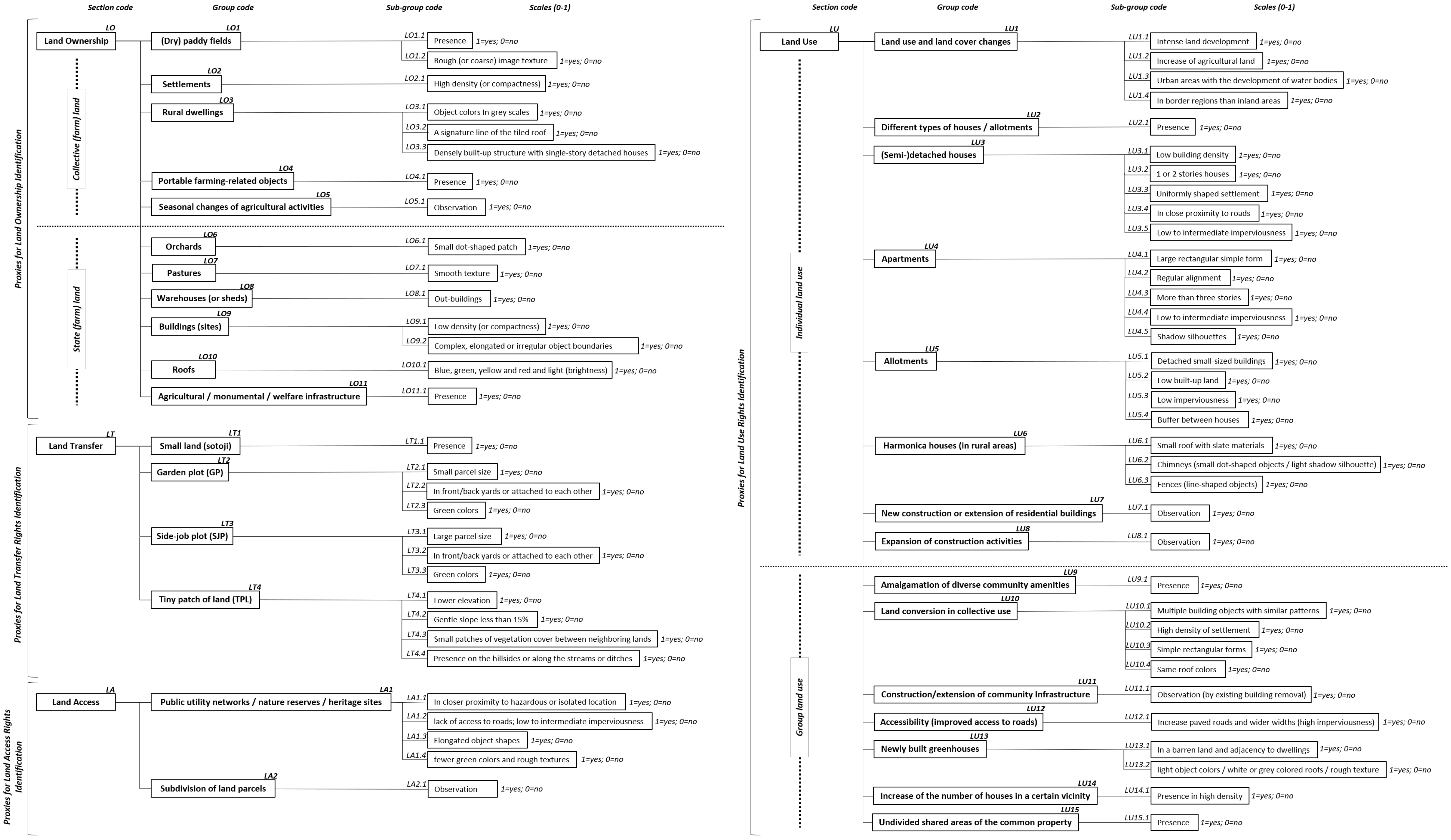
4.1. Identification of Proxies

4.1.1. Land Ownership (LO)

To identify land ownership, 15 proxies were incorporated in the analysis (See Figure 1). Of these 15 proxies, first eight (LO. 1 to LO. 8) were associated with the identification of collective (farm)land and the remainder (LO. 9 to LO. 15) with state (farm)land. Null hypothesis (H0) cannot be rejected, i.e., that there is no difference between scientific, bureaucratic and stakeholder distributions for nine proxies. For these nine proxies, the judgements elicited from scientific knowledge are in agreement with those observed in bureaucratic groups. On the other hand, we reject the null hypothesis that there is no difference between the three different knowledge groups for the following six proxies: rough/coarse image texture of (dry)paddy fields, high density/compactness of settlements, signature line of a slanting roof of rural dwellings, observation of seasonal changes in agricultural activities, small dot-shaped patch of orchards, smooth texture of pastures, and low density of building (sites).
It was found that the Table 2 compares the results obtained in the Chi-square test of validating the suitability of proxies for land ownership identification. In general, when a p-value is less than 0.05 for each proxy (No 2, 3, 5, 8 to 10, and 12), it means that the agreements elicited from the scientific, bureaucratic, and stakeholder groups are highly inconsistent, and thus hinder validating the suitability of a set of proxies. Although there is higher rates of disagreement among scientific group (ranging from 13.8 % to 48.3%) arising from the interpretations of the identified proxies, the possible proxies for land ownership identification derived from EO data (LOs. 1, 4, 6, 7, 11, and 13 to 15) achieved a better understanding among the bureaucratic (mean average: 46.2%) and stakeholder groups (mean average: 63.9%).

4.1.2. Land Use Rights (LU)

There were 35 proxies incorporated for the identification of LU from EO data. Proxies LU. 1 to LU. 24 reflect aspects of individual land use rights, while another explanation of group land use right is associated with proxies LU. 25 to LU. 35. Significant associations for the difference between scientific, bureaucratic and stakeholder’s agreements were not found to be related throughout a Chi-square test for all the possible proxies of land use rights. In other words, we retain the null hypothesis (p value ≤ 0.05) that there is no difference between the knowledge groups. All participant groups agreed that much uncertainty (judging by the agreement ratio of ≤ 50%) still exists concerning the relationship between EO data and the identification of land use rights at some points. However, statistical difference does not fully account for difference in actual opinions. In other words, the χ2 and p values only demonstrate a statistically significant difference, which is the result of a rational exercise with numbers but does not denote any practical significance in that there is no difference.
Table 3 shows the breakdown of χ2 and p values along with the fraction of total agreement for validating the suitability of proxies for identifying land use rights. There is still no systematic understanding of how EO data contributes to land use rights identification (LUs. 11 to 15, and 24) among scientific, bureaucratic and stakeholder knowledge groups (less than 30% are in agreement); however, strong evidence was found in support of the validation of the six proxies in individual and seven proxies in group land use rights with agreement of at least 40 percent in two separate groups (LUs. 5, 6, 7, 16, 17, 22, 25 to 27, 29 to 31, and 34).

4.1.3. Land Transfer Rights (LT)

The proxies used to identify LT had 11 responses to the questions of each knowledge group based on the following key components: small plots (sotoji) divided into a garden plot (GP), side-job plot (SJP), and a tiny patch of land (TPL) in North Korea. As with data obtained in the previous section on land use rights identification, we also found that there is no statistical difference in a set of given observations (p value ≥ 0.05). Therefore, we do not reject the null hypothesis for the difference in views, judgements, and experiences between scientific, bureaucratic, and stakeholder distributions on the proposed proxies for land transfer rights. There remain several aspects concerning small plots (sotoji) about which relatively little is known to scientific and bureaucratic knowledge groups in South Korea (only less than a third (30%) agreed on confirming land transfer rights). However, if we could turn for a moment to look at both Table 4, we can see that the stakeholder group with the most accurate understanding of land tenure relations, land governance and land use practices had a higher mean estimated percentage (32%) of agreement than the average ratio of other groups, with the validation of eleven proxies. This is especially the case with LT. 2 (38.9%), LT. 3 (44.4%), LT. 4 (38.9%), and LT. 6 (44.4%).

4.1.4. Land Access Rights (LA)

As mentioned in the previous study [21], assuming and identifying EO data proxies for LA in North Korea is one of the most challenging problems, as private land tenure is not recognized in North Korea, and thus there are no land use regulations arising through the restriction of private rights. With regard to restrictions of land access rights for public purpose only, five proxies were included in the analysis. On average, these proxies received the highest agreement among identified land tenure claims, ranging from 34.5% to 70% among scientific, bureaucratic, and stakeholder knowledge groups. As Table 5 shows, there is a significant difference between the bureaucratic and scientific/stakeholder groups in the proxy with fewer green colors and rough textures in public utility networks/nature reserves/heritage sites. Thus, the null hypothesis that there is no difference between scientific, bureaucratic, and stakeholder distributions for this proxy cannot be rejected. What is interesting about the data here is that the bureaucratic knowledge group obtained the highest level of agreement on proxy identification (63.3%, 60.0%, 70.0%, 66.7%, and 50.0%, respectively in order).

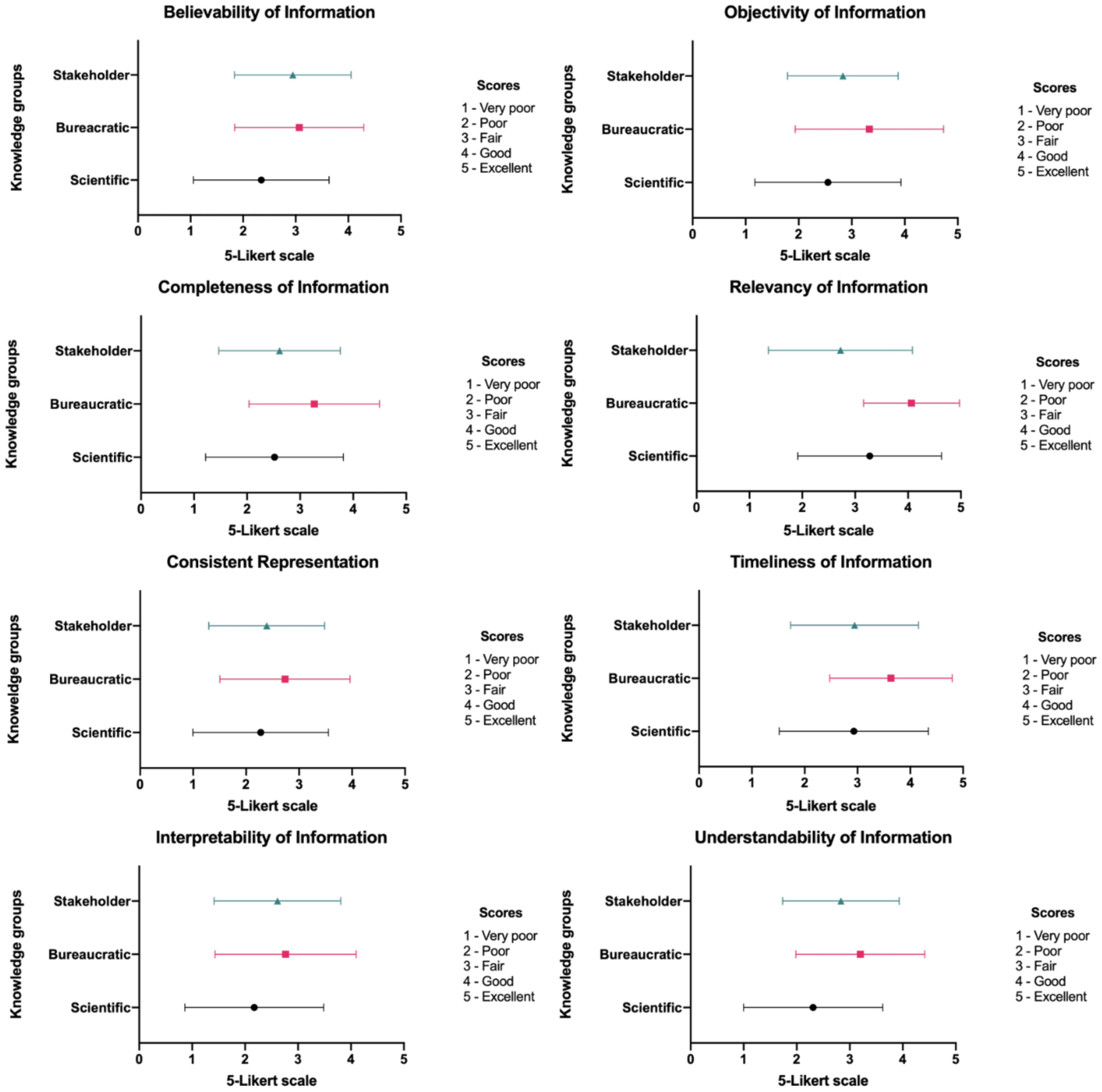
4.2. Measurement of Information Quality

The participants were asked to consider data, information, or knowledge with regard to whether an elaborated meaning or an interpreted information element is valid or not and then to complete an eight-question survey about information quality. Of the eight aspects, there was no statistically significant differences between group mean values (1–5) for believability, completeness, consistent representation, interpretability, objectivity, and timeliness as determined by one-way ANOVA. This indicates a high level of consensus on information quality among the different knowledge groups. On the other hand, there was a significant difference from those of variables between the means of three groups both on relevancy at the p value ≤ 0.05 level for the three conditions (between/within/total) and understandability of information (see Table 6). However, the one-way ANOVA test does not tell us where the difference exists, and which specific groups differed. The post hoc Tukey test indicated that the relevancy in scientific and bureaucratic groups (A–B) and bureaucratic and stakeholder (B–C) groups differed significantly at p ≤ 0.05; regarding understandability, there was a statistically significant difference (p = 0.018) between the scientific and bureaucratic (A–B) groups (see Table 7).
Figure 2 also displays an average of a range of values (1–5) for each level of information quality in different knowledge groups. What stands out is that the bureaucratic group has the highest median within the samples in all aspects of information quality, while scientific (M = 2.5) and stakeholder knowledge (M = 2.7) groups had a lower mean score compared to the bureaucratic groups, except in relevancy of information. The results, indicate that relevancy of information received relatively positive scores from bureaucratic (M = 4.1) and scientific groups (M = 3.3); on average, respondents from all groups reported lower levels of consistent representation (M = 2.46602) and interpretability (M = 2.5).

5. Summary and Discussion

The principal limitation of closed questions in a questionnaire restricted respondents’ answers and expressiveness, enabling us to clarify and confirm the proxies we preidentified (in Figure 1). A small sample was chosen because of the expected difficulty in obtaining a high-level of expertise and an accurate understanding in the given context, based on the fact that significant uncertainty exists regarding geospatial and socio-economic data access, data integration, and data reliability.
Up to now, there have been no controlled studies which compare differences in findings. However, the experimental work presented here provides first investigation how pixel-based land tenure information become legitimate land tenure knowledge to some extent. Although differences of agreement still exist, the most obvious findings to emerge from the analysis is that there appears to be some agreement in judgements of proxies among scientific, bureaucratic, and stakeholder groups. They agree on some proxies but not on others. Weak associations of EO data and land ownership were identified for eight proxies, including such as coarse image texture of (dry)paddy fields, high density/compactness of settlements, a linear roof of rural dwellings, seasonal changes of agricultural activities, and small dot-shaped patch or orchards.. On the other hand, some proxies are associated with both collective and state land ownership and are strongly supported by bureaucratic and stakeholder groups that stress the political and strategic use of proxies and possess the most localized and contextualized knowledge.
With regard to proxies for land use rights identification, we can confirm that six proxies relating to individual use rights such as presence of different types of houses/allotments, detached small-size allotment buildings and low built-up allotment land and seven to group land use rights (e.g., amalgamation of community amenities and increase in the number of houses in a certain vicinity) were identified out of a total of 35 proxies. These were found to be particularly associated with houses, allotments, land conversions and improvements to the location. However, no significant agreement was found for all groups, especially in apartment-types of proxies (e.g., rectangular forms, regular alinements, imperviousness, or shadow silhouettes of apartments). These proxies could have been generated by misclassification bias or an erroneous assumption when identifying geospatially informed proxies. The reason for this is not clear but it may have something to do with the nature of apartments where multiple objects reside.
In addition, the findings indicate that elements of EO data interpretation such as color, shape, size, height, and site (e.g., large parcel size of SJP, SJP with green colors, lower elevation, and gentle slope of TPL) may not be associated with land transfer rights. However, there is a knowledge gap resulting from a lack of clear understanding of specific aspects and details of small plots (sotoji) in North Korea by South Korean scientists and government professionals. The stakeholder group that has the most accurate understanding of land tenure relations, land governance and land use practice showed significantly higher ratio of agreement. Regarding the identification of land access rights, whilst there was strong agreement in the validation of proxies between all knowledge groups and considered to be most negotiated knowledge that is scientifically most valid, policy-relevant, and socially robust among others in this study. As far as infrastructure elements are concerned, three groups have shown a higher level of agreement among other proxy selections. We may assume that a proxy identification in relation to infrastructure in North Korea could be more important than anything else. In other words, it is possible that these identified proxies could account for unknown aspects of land access rights in North Korea.
However, these results also need to be interpreted with caution. Firstly, we revealed a strong and consistent association between land ownership and EO data and the mean average of agreement in stakeholder groups—for those with the most localized knowledge of land tenure—were higher compared to those of other groups. If the debate is to be moved forward, a better understanding of different perceptions on land tenure among North Korean refugees needs to be developed. It can be relatively easier for North Korean refugees to distinguish collective and state (farm)land through EO data because they have empirically familiar with the socialist land tenure system. Another reason to support this claim may be that there was an obvious difficulty with defining the term which have accustomed with South Korean land management practices.
Secondly, the present results were significant in at least two major respects. The experimental data suggested that the three groups considered in this study were all in a higher degree of agreement on identifying land use rights, nothing in particular really stood out, but the agreement was distributed evenly at a relatively higher level than the average of those observed in other claims. However, some of those experts still argued that idea was not feasible to empirically derive changes in land use rights in North Korea with EO data. Despite the fact that there has been increased numbers of North Korean refugees (approximately 30,000 residents), one argued that it still remained challenging to understand the notion of "individual" land use rights, according to his/her own experiences of having worked and lived in North Korea.
Thirdly, all knowledge groups showed that the proxies for land transfer rights identification were appeared to the lowest in the level of agreement. However, the questions came up against the great problem of reliability of reported data and we are often not in a position to know whether it enabled participants to provide fairer, more objective, and more accurate and reliable assessments for validating the suitability of geospatially informed proxies. For instance, making a judgement on this, however, inevitably makes additional demands for expertise of either land management or remote sensing. Furthermore, these validations require in-depth local knowledge of the distinguishing feature in North Korea (i.e., sotoji) that is necessary to make association between EO data and land transfer rights. To further identify the proxies, it is necessary to rely on multiple techniques and methods, which combine both direct responses of individual, ranked, and stated choice responses of either individuals or groups and indirect collections of perceptions, beliefs, and social values. In addition to interviews and focus group discussions (FGD), one could add a number of other relevant tools and techniques, such as, Q methodology (which combines quantitative and qualitative data collections techniques with statistical and interpretative data analyses methods), the Delphi technique (which relies on consecutive perceptions and interpretations), and multi-criteria decision analysis (MCDA) (which combines and infers from multiple opinions and preferences).
In order to ensure whether proposed proxies for land access rights were valid, the participants were asked to select between the two, either agree or disagree. Of the 77 participants who completed the questionnaire, nearly half reported that land access rights could be identified in line with the proxies and the EO data. One could argue that this finding is largely biased by the selection of respondents who had similar epistemic backgrounds. The consequence of this bias could be that the understanding of what land rights constitute and what not, would reflect the acquaintance with private rights tenure regimes only and perhaps more limited awareness and experience with State-based tenure regimes. Hence, it is important to keep this possible bias in these responses in mind, especially from scientific and bureaucratic groups.
Nevertheless, regarding the measurement of information quality (see Figure 2), the result was that we expected. Although EO data proxy identification for land tenure relations in North Korea seems to be strongly relevant to respondents’ research, policies, and social interests (i.e., relevancy of information; timeless of information), many participants did suffer from a lack of consistent representation and interpretability of information. In order to further investigate and confirm this finding, a provision of multi-disciplinary training will enhance both researchers’ capacity to understand land tenure and land governance in question and policymakers’ confidence in making spatial decisions in the context of Korean (re-)unification based on GIA. This also enables multiple engaged stakeholders to reveal the interconnection of geospatial science in land management practice. All these require affinity with multiple technical disciplines such as geoinformation and earth observation sciences, civil and environmental engineering as well as sensitivity of social and political processes including public administration, law, economics, and (human) geography. Secondly, one major drawback when implementing GIA was that non-remote sensing scientists, government professionals and North Korean refugees were suffered from scientific and technological literacy [75,76] (i.e., a high density of technical terms of remote sensing used in research). As this case very clearly demonstrated, it is important that reformulating the scientific language in a communicative style should be considered to facilitate active stakeholders’ engagement in advancing GIA. Lastly, the existing and grounded knowledge of GIA needs to be translated into voluntary guidelines, policy briefs for scientists, policymakers, and other interest groups. In addition, fact-finding projects from around the globe where unknown land tenure and unsupported land governance exists needs to be implemented.
Different forms of evidence can be used to inform spatial decision making in land management, with data being gathered via statistical and administrative evidence (from government), analytical evidence (by scientific experts), evidence from citizens and stakeholders and evidence from evaluations [77]. This also accords with our approaches, which showed that how a knowledge co-production process helps to validate suitability of geospatially informed proxies and become legitimate land tenure knowledge. Given the fact that this study has to be conducted with the best of all qualities, it should confirm or reject our hypotheses as analytical evidence that may report a possible association between EO data and land tenure with a case study in North Korea. Then, by incorporating and reflecting on local spatial knowledge from multiple stakeholders (i.e., scientists, government professionals and North Korean refugees), it enabled us to tell policymakers what land tenure knowledge they consider legitimate (i.e., scientific validity, policy relevance and social robustness) and what counts as geospatially informed evidence. It is only after knowledge (evidence) co-production processes, the finding of this study supports the view that we can bridge and close the gap between technical aspects of the EO data evidence generation and operational contexts in spatial decision making in land administration and management. Much of the available literature so far on remote sensing for land administration is too product-oriented for skilled and trained technicians [12,13,14,15,16,17,18,19] and insufficiently process-oriented for policymakers and end-users, allowing them to make decisions in the most rational and informed way possible with EO data [22]. The point is not to go against the promising ideas on RS applications, techniques, products, and methods, but to really emphasize that it is an opportune time to undertake the most engaged and negotiated knowledge for both evidence generation and provision of salient and legitimate evidence in responsible and smart decision-making in land administration. This approach can be a way forward remote sensing for land administration 2.0.

6. Conclusions

The aim of the research question in this study was to determine the extent to which scientific, bureaucratic, and stakeholder knowledge coincides with a set of identified proxies that would enable us to conclude whether certain proposed proxies are scientifically valid, administratively relevant, contextualized, and localized. The findings from this study could then be used to standardize the identification and categorization of certain objects, environments, and semantics visible in EO data that can (re-)interpret land tenure relations in North Korea in preparation for Korean (re-)unification.
Of the four different land tenure claims, both Chi-square and one-way ANOVA analysis revealed that the distribution of agreements relating to land ownership and land transfer rights identification varied among scientific experts, bureaucrats, and stakeholders. Moreover, it was possible to measure intrinsic, contextual, representational, and accessibility attributes of comprehensive information to ascertain associations between EO data and land tenure relations in North Korea based on different viewpoints. From here, the step towards enhancing and developing the existing account is clearly supported by the current findings on information quality.
The findings of this investigation complement those of a previous study relating to a conceptual and methodological development of a geospatially informed analysis in the land administration domain [21]. These findings contribute in several ways to our understanding of how the pixel can be converted to legitimate land tenure knowledge. First, it can help us establish a tailored validation protocol with a higher accuracy and feasibility based on the identification and interpretation of unknown land tenure relations derived from EO data and various types of contextual information as well as a more nuanced view of socio-legal-spatial properties. Second, these findings, being based on knowledge co-production, are relevant to scientists, policy-makers, and practitioners involved in the decision making process relating to land tenure reform and land governance rearrangement on the basis of emerging geospatial technologies and datasets in the context of Korean (re-)unification. Furthermore, the methods used in this study can also be applied to other cases elsewhere in the world, in particular, difficult-to-access regions or fragile and conflict-affected areas. Lastly, the present study contributes additional evidence of geospatially better-informed analysis that emphasizes scientific validity, policy relevance, and social robustness within a responsible and smart land management framework. The geospatially better-informed analysis is not about how geospatial intelligence can directly detect information but how technology can smartly and responsibly support better information regarding land issues for the benefit of scientists, policymakers, and stakeholders.
Although the current study is based on a small sample of participants and used a focus group questionnaire, it offers valuable insights into new validation techniques of suitability for EO data in the land administration domain based on conventional practices that have been formed and customized to accommodate the specific artefacts and validation objectives used in the remote sensing community. The scope of this study was limited in terms of participants’ knowledge, for example their level of expertise (scientific), administrative involvement (bureaucratic), and knowledge of locales in geographic areas of interest (stakeholder). However, the limited number of samples adds further caution regarding the generalizability of these findings. Thus, further investigation and experimentation to develop the internal and external validity of findings and GIA methodology would be of great help in understanding the associations between EO data and land tenure claims. Considerably more work will need to be done to identify intrinsic links between geospatial data and land tenure relations. It will then be necessary to concentrate on the development of EO data interpretation in line with artificial intelligence (AI) so as to be able to delve deeper into the future of land administration.

Author Contributions

Conceptualization, C.L.; methodology, C.L.; software, C.L.; validation, C.L. and W.T.d.V.; formal analysis, C.L.; investigation, C.L.; resources, C.L.; data curation, C.L.; writing—original draft preparation, C.L.; writing—review and editing, C.L. and W.T.d.V.; visualization, C.L.; supervision, W.T.d.V.; project administration, C.L. All authors have read and agreed to the published version of the manuscript.

Funding

This work was supported by the German Research Foundation (DFG) and the Technical University of Munich (TUM) in the framework of the Open Access Publishing Program.

Institutional Review Board Statement

Not applicable.

Informed Consent Statement

All prospective participants had been informed all the information (i.e., voluntary nature of study, risks, benefits, procedures to maintain confidentiality, etc.) and agreed to participate before proceeding the E-survey.

Acknowledgments

We thank three anonymous reviewers for their insightful comments in narrowing the gap between our claims and the actual content of the manuscript. We are also immensely grateful to colleagues in Korea who have helped and supported in conducting surveys, including survey creation and distribution. Last but not the least, I am also very thankful to the respondents who provided their insight, expertise and views, although any errors are our own and should not tarnish the reputations of these esteemed persons.

Conflicts of Interest

The authors declare no conflict of interest.

References

  1. Avtar, R.; Komolafe, A.A.; Kouser, A.; Singh, D.; Yunus, A.P.; Dou, J.; Kumar, P.; Gupta, R.D.; Johnson, B.A.; Thu Minh, H.V.; et al. Assessing sustainable development prospects through remote sensing: A review. Remote Sens. Appl. Soc. Environ. 2020, 20, 100402. [Google Scholar] [CrossRef]
  2. Sapena, M.; Wurm, M.; Taubenböck, H.; Tuia, D.; Ruiz, L.A. Estimating quality of life dimensions from urban spatial pattern metrics. Comput. Environ. Urban Syst. 2021, 85, 101549. [Google Scholar] [CrossRef]
  3. Warth, G.; Braun, A.; Assmann, O.; Fleckenstein, K.; Hochschild, V. Prediction of Socio-Economic Indicators for Urban Planning Using VHR Satellite Imagery and Spatial Analysis. Remote Sens. 2020, 12, 1730. [Google Scholar] [CrossRef]
  4. Watmough, G.R.; Marcinko, C.L.J.; Sullivan, C.; Tschirhart, K.; Mutuo, P.K.; Palm, C.A.; Svenning, J.-C. Socioecologically informed use of remote sensing data to predict rural household poverty. Proc. Natl. Acad. Sci. USA 2019, 116, 1213. [Google Scholar] [CrossRef] [Green Version]
  5. You, Z.; Shi, H.; Feng, Z.; Yang, Y. Creation and validation of a socioeconomic development index: A case study on the countries in the Belt and Road Initiative. J. Clean. Prod. 2020, 258, 120634. [Google Scholar] [CrossRef]
  6. Brown, M.E.; Grace, K.; Shively, G.; Johnson, K.B.; Carroll, M. Using satellite remote sensing and household survey data to assess human health and nutrition response to environmental change. Popul. Environ. 2014, 36, 48–72. [Google Scholar] [CrossRef] [Green Version]
  7. Greenough, P.G.; Nelson, E.L. Beyond mapping: A case for geospatial analytics in humanitarian health. Confl. Health 2019, 13, 50. [Google Scholar] [CrossRef] [PubMed]
  8. Jean, N.; Burke, M.; Xie, M.; Davis, W.M.; Lobell, D.B.; Ermon, S. Combining satellite imagery and machine learning to predict poverty. Science 2016, 353, 790–794. [Google Scholar] [CrossRef] [Green Version]
  9. Kuffer, M.; Thomson, D.R.; Boo, G.; Mahabir, R.; Grippa, T.; Vanhuysse, S.; Engstrom, R.; Ndugwa, R.; Makau, J.; Darin, E.; et al. The Role of Earth Observation in an Integrated Deprived Area Mapping “System” for Low-to-Middle Income Countries. Remote Sens. 2020, 12, 982. [Google Scholar] [CrossRef] [Green Version]
  10. Balaji, L.; Muthukannan, M. Investigation into valuation of land using remote sensing and GIS in Madurai, Tamilnadu, India. Eur. J. Remote Sens. 2020, 1–9. [Google Scholar] [CrossRef]
  11. Dale, P.; McLaughlin, J. Land Administration; Oxford University Press: Oxford, UK, 2000. [Google Scholar]
  12. Bennett, R.; Oosterom, P.v.; Lemmen, C.; Koeva, M. Remote Sensing for Land Administration. Remote Sens. 2020, 12, 2497. [Google Scholar] [CrossRef]
  13. Crommelinck, S.; Koeva, M.; Yang, M.Y.; Vosselman, G. Application of Deep Learning for Delineation of Visible Cadastral Boundaries from Remote Sensing Imagery. Remote Sens. 2019, 11, 2505. [Google Scholar] [CrossRef] [Green Version]
  14. Fetai, B.; Oštir, K.; Kosmatin Fras, M.; Lisec, A. Extraction of Visible Boundaries for Cadastral Mapping Based on UAV Imagery. Remote Sens. 2019, 11, 1510. [Google Scholar] [CrossRef] [Green Version]
  15. Koeva, M.; Nikoohemat, S.; Oude Elberink, S.; Morales, J.; Lemmen, C.; Zevenbergen, J. Towards 3D Indoor Cadastre Based on Change Detection from Point Clouds. Remote Sens. 2019, 11, 1972. [Google Scholar] [CrossRef] [Green Version]
  16. Koeva, M.; Stöcker, C.; Crommelinck, S.; Ho, S.; Chipofya, M.; Sahib, J.; Bennett, R.; Zevenbergen, J.; Vosselman, G.; Lemmen, C.; et al. Innovative Remote Sensing Methodologies for Kenyan Land Tenure Mapping. Remote Sens. 2020, 12, 273. [Google Scholar] [CrossRef] [Green Version]
  17. Park, S.; Song, A. Discrepancy Analysis for Detecting Candidate Parcels Requiring Update of Land Category in Cadastral Map Using Hyperspectral UAV Images: A Case Study in Jeonju, South Korea. Remote Sens. 2020, 12, 354. [Google Scholar] [CrossRef] [Green Version]
  18. Xia, X.; Persello, C.; Koeva, M. Deep Fully Convolutional Networks for Cadastral Boundary Detection from UAV Images. Remote Sens. 2019, 11, 1725. [Google Scholar] [CrossRef] [Green Version]
  19. Yan, J.; Jaw, S.W.; Soon, K.H.; Wieser, A.; Schrotter, G. Towards an Underground Utilities 3D Data Model for Land Administration. Remote Sens. 2019, 11, 1957. [Google Scholar] [CrossRef] [Green Version]
  20. Stöcker, C.; Ho, S.; Nkerabigwi, P.; Schmidt, C.; Koeva, M.; Bennett, R.; Zevenbergen, J. Unmanned Aerial System Imagery, Land Data and User Needs: A Socio-Technical Assessment in Rwanda. Remote Sens. 2019, 11, 1035. [Google Scholar] [CrossRef] [Green Version]
  21. Lee, C.; de Vries, W.T. Bridging the Semantic Gap between Land Tenure and EO Data: Conceptual and Methodological Underpinnings for a Geospatially Informed Analysis. Remote Sens. 2020, 12, 255. [Google Scholar] [CrossRef] [Green Version]
  22. Bégué, A.; Leroux, L.; Soumaré, M.; Faure, J.-F.; Diouf, A.A.; Augusseau, X.; Touré, L.; Tonneau, J.-P. Remote Sensing Products and Services in Support of Agricultural Public Policies in Africa: Overview and Challenges. Front. Sustain. Food Syst. 2020, 4. [Google Scholar] [CrossRef]
  23. Jewiss, J.L.; Brown, M.E.; Escobar, V.M. Satellite Remote Sensing Data for Decision Support in Emerging Agricultural Economies: How Satellite Data Can Transform Agricultural Decision Making [Perspectives]. IEEE Geosci. Remote Sens. Mag. 2020, 8, 117–133. [Google Scholar] [CrossRef]
  24. Head, B.W. Toward More “Evidence-Informed” Policy Making? Public Adm. Rev. 2016, 76, 472–484. [Google Scholar] [CrossRef]
  25. Parkhurst, J. The Politics of Evidence: From Evidence-Based Policy to the Good Governance of Evidence; Taylor & Francis: Abingdon, UK, 2017. [Google Scholar]
  26. Nutley, S.M.; Nutley, S.; Walter, I.; Davies, H.T. Using Evidence: How Research Can Inform Public Services; Policy Press: Bristol, UK, 2007. [Google Scholar]
  27. Oliver, K.; Lorenc, T.; Innvær, S. New directions in evidence-based policy research: A critical analysis of the literature. Health Res. Policy Syst. 2014, 12, 1–11. [Google Scholar] [CrossRef]
  28. Shaxson, L.; Datta, A.; Tshangela, M.; Matomela, B. Understanding the Organisational Context for Evidence-Informed Policy-Making; Department of Environmental Affairs: Pretoria, South Africa, 2016.
  29. Jung, E.-E. A Study on the Research Methodology of the North Korean Economy. In KDI Review of the North Korean Economy; Korea Development Institute: Sejong, Korea, 2019; pp. 63–65. [Google Scholar]
  30. Kang, J.W. North Korean Studies and the Uses of Qualitative Methodology. J. Asiat. Stud. 2015, 58, 66–97. [Google Scholar]
  31. Koh, Y.-H. A Study on the Research Trends of North Korean Studies after the Division of South and North Korea in 1945. Unification Policy Stud. 2015, 24, 29–54. [Google Scholar]
  32. Koh, Y.-H. A Study on Trends and Issues of North Korean Studies. J. Peace Unification Stud. 2019, 11, 5–32. [Google Scholar]
  33. Lee, H.K. The Present Status and Desirable Direction of North Korean Study. J. Peace Stud. 2010, 11, 83–104. [Google Scholar]
  34. Ryu, K.; Kim, Y.H. A Jasmine Revolution in North Korea? Looking for Alternative Approaches to the Study of North Korean Regime Change. North Korean Stud. Rev. 2012, 16, 399–431. [Google Scholar]
  35. Choe, S.C.; Lee, Y.S. A Study on Land Ownership and Use in North Korea. J. Korean Reg. Sci. Assoc. 1998, 14, 1–33. [Google Scholar]
  36. Choi, M.J.; Kim, H.-S.; Kim, Y.S.; Park, E.-S. An Application of South Korean Land and Housing Legislations to Real Estate Asset Distribution for North Korean Residents After Unification. J. Korea Plan. Assoc. 2015, 50, 89–103. [Google Scholar] [CrossRef]
  37. Kim, H.-S.; Seo, S.T.; Kim, D.-H.; Jeong, Y.W.; Choi, D.-S.; Cho, K.-H. Urban Planning of North Korea after Unification. Urban Inf. Serv. 2014, 389, 3–17. [Google Scholar]
  38. Kim, S.Y. A Study on the Formation and Changes of Socialist Land System in North Korea and its Future Directions after Unification. In Real Estate Focus; Research Institute of Korea Appraisal Board: Seoul, Korea, 2012; pp. 64–78. [Google Scholar]
  39. Lee, C.; de Vries, W.T. A divided nation: Rethinking and rescaling land tenure in the Korean (re-)unification. Land Use Policy 2018, 75, 127–136. [Google Scholar] [CrossRef]
  40. Lee, C.; de Vries, W.T.; Chigbu, U.E. Land Governance Re-Arrangements: The One-Country One-System (OCOS) Versus One-Country Two-System (OCTS) Approach. Adm. Sci. 2019, 9, 21. [Google Scholar] [CrossRef] [Green Version]
  41. Park, M.; Do, J. Research on North Korean Defectors’ Values using the Focus Group Interview (FGI) Method: Its Objectives, Methodology, and Significance. J. Humanit. Unification 2019, 79, 5–35. [Google Scholar] [CrossRef]
  42. Hong, M. The Marketization and Social Mobility in North Korea: Spatial Structure·Urban Politics·Social Stratum; Korea Institute for National Unification: Seoul, Korea, 2015. [Google Scholar]
  43. Shadbolt, N.R.; Smart, P.R.; Wilson, J.; Sharples, S. Knowledge elicitation: Methods, Tools and Techniques. In Evaluation of Human Work; CRC Press: Boca Raton, FL, USA, 2015; pp. 163–200. [Google Scholar]
  44. Mukherjee, N.; Zabala, A.; Huge, J.; Nyumba, T.O.; Adem Esmail, B.; Sutherland, W.J. Comparison of techniques for eliciting views and judgements in decision-making. Methods Ecol. Evol. 2018, 9, 54–63. [Google Scholar] [CrossRef] [Green Version]
  45. Jeong, E.-M. Application and Trend of Researches on North Korean Refugees as a Method of North Korea Studies. Rev. North Korean Stud. 2005, 8, 139–176. [Google Scholar]
  46. Park, S.; Kim, T.; Kim, S.; Song, J. Urban Planning and Development Practices in North Korea: Urban Consequences of Informal Market; Korea Research Institute for Human Settlements: Sejong, Korea, 2016. [Google Scholar]
  47. Olofsson, P.; Foody, G.M.; Herold, M.; Stehman, S.V.; Woodcock, C.E.; Wulder, M.A. Good practices for estimating area and assessing accuracy of land change. Remote Sens. Environ. 2014, 148, 42–57. [Google Scholar] [CrossRef]
  48. Congalton, R.G. Accuracy assessment and validation of remotely sensed and other spatial information. Int. J. Wildland Fire 2001, 10, 321–328. [Google Scholar] [CrossRef] [Green Version]
  49. Campbell, J.B.; Wynne, R.H. Introduction to Remote Sensing, 5th ed.; Guilford Press: New York, NY, USA, 2011. [Google Scholar]
  50. Radoux, J.; Bogaert, P. Good Practices for Object-Based Accuracy Assessment. Remote Sens. 2017, 9, 646. [Google Scholar] [CrossRef] [Green Version]
  51. Kelly, A.B.; Kelly, N.M. Validating the remotely sensed geography of crime: A review of emerging issues. Remote Sens. 2014, 6, 12723–12751. [Google Scholar] [CrossRef] [Green Version]
  52. Aditya, T.; Maria-Unger, E.; Bennett, R.; Saers, P.; Lukman Syahid, H.; Erwan, D.; Wits, T.; Widjajanti, N.; Budi Santosa, P.; Atunggal, D. Participatory Land Administration in Indonesia: Quality and Usability Assessment. Land 2020, 9, 79. [Google Scholar] [CrossRef] [Green Version]
  53. Asiama, K.; Bennett, R.; Zevenbergen, J. Participatory land administration on customary lands: A practical VGI experiment in Nanton, Ghana. ISPRS Int. J. Geo Inf. 2017, 6, 186. [Google Scholar] [CrossRef] [Green Version]
  54. Wassie, Y.A.; Koeva, M.N.; Bennett, R.M.; Lemmen, C.H.J. A procedure for semi-automated cadastral boundary feature extraction from high-resolution satellite imagery. J. Spat. Sci. 2018, 63, 75–92. [Google Scholar] [CrossRef] [Green Version]
  55. Loew, A.; Bell, W.; Brocca, L.; Bulgin, C.E.; Burdanowitz, J.; Calbet, X.; Donner, R.V.; Ghent, D.; Gruber, A.; Kaminski, T.; et al. Validation practices for satellite-based Earth observation data across communities. Rev. Geophys. 2017, 55, 779–817. [Google Scholar] [CrossRef] [Green Version]
  56. Armitage, D.; Berkes, F.; Dale, A.; Kocho-Schellenberg, E.; Patton, E. Co-management and the co-production of knowledge: Learning to adapt in Canada’s Arctic. Glob. Environ. Chang. 2011, 21, 995–1004. [Google Scholar] [CrossRef]
  57. Edelenbos, J.; van Buuren, A.; van Schie, N. Co-producing knowledge: Joint knowledge production between experts, bureaucrats and stakeholders in Dutch water management projects. Environ. Sci. Policy 2011, 14, 675–684. [Google Scholar] [CrossRef]
  58. Pohl, C.; Rist, S.; Zimmermann, A.; Fry, P.; Gurung, G.S.; Schneider, F.; Speranza, C.I.; Kiteme, B.; Boillat, S.; Serrano, E.; et al. Researchers’ roles in knowledge co-production: Experience from sustainability research in Kenya, Switzerland, Bolivia and Nepal. Sci. Public Policy 2010, 37, 267–281. [Google Scholar] [CrossRef] [Green Version]
  59. Lee, C.; de Vries, W.T. Sustaining a Culture of Excellence: Massive Open Online Course (MOOC) on Land Management. Sustainability 2019, 11, 3280. [Google Scholar] [CrossRef] [Green Version]
  60. Freedman, B. Scientific Value and Validity as Ethical Requirements for Research: A Proposed Explication. IRB Ethics Hum. Res. 1987, 9, 7–10. [Google Scholar] [CrossRef]
  61. Schie, N.V.; Duijn, M.; Edelenbos, J. Co-Valuation: Exploring methods for expert and stakeholder valuation. J. Environ. Assess. Policy Manag. 2011, 13, 619–650. [Google Scholar] [CrossRef]
  62. Eckhard, S. Bridging the citizen gap: Bureaucratic representation and knowledge linkage in (international) public administration. Governance 2020. [Google Scholar] [CrossRef] [Green Version]
  63. Kingdon, J.W.; Stano, E. Agendas, Alternatives, and Public Policies; Little, Brown: Boston, MA, USA, 1984; Volume 45. [Google Scholar]
  64. McClean, S.; Shaw, A. From Schism to Continuum? The Problematic Relationship Between Expert and Lay Knowledge—An Exploratory Conceptual Synthesis of Two Qualitative Studies. Qual. Health Res. 2005, 15, 729–749. [Google Scholar] [CrossRef]
  65. Hunt, J.; Shackley, S. Reconceiving Science and Policy: Academic, Fiducial and Bureaucratic Knowledge. Minerva 1999, 37, 141–164. [Google Scholar] [CrossRef]
  66. Stilgoe, J. The (co-)production of public uncertainty: UK scientific advice on mobile phone health risks. Public Underst. Sci. 2007, 16, 45–61. [Google Scholar] [CrossRef]
  67. Gray, S.; Chan, A.; Clark, D.; Jordan, R. Modeling the integration of stakeholder knowledge in social–ecological decision-making: Benefits and limitations to knowledge diversity. Ecol. Model. 2012, 229, 88–96. [Google Scholar] [CrossRef]
  68. Petts, J.; Brooks, C. Expert Conceptualisations of the Role of Lay Knowledge in Environmental Decisionmaking: Challenges for Deliberative Democracy. Environ. Plan. A Econ. Space 2006, 38, 1045–1059. [Google Scholar] [CrossRef]
  69. Enemark, S.; Bell, K.; Lemmen, C.; McLaren, R. Fit-For-Purpose Land Administration; FIG Publication. No. 60; International Federation of Surveyors: Copenhagen, Denmark, 2014. [Google Scholar]
  70. de Vries, W.T.; Bugri, J.T.; Mandhu, F. Responsible and Smart Land Management Interventions: An African Context; CRC Press: Boca Raton, FL, USA, 2020. [Google Scholar]
  71. de Vries, W.T.; Chigbu, U.E. Responsible land management-Concept and application in a territorial rural context. Fub. Flächenmanag. Bodenordn. 2017, 79, 65–73. [Google Scholar]
  72. Lee, Y.W.; Strong, D.M.; Kahn, B.K.; Wang, R.Y. AIMQ: A methodology for information quality assessment. Inf. Manag. 2002, 40, 133–146. [Google Scholar] [CrossRef]
  73. McDonald, J.H. Handbook of Biological Statistics; Sparky House Publishing: Baltimore, MD, USA, 2009; Volume 2. [Google Scholar]
  74. Warner, P. Testing association with Fisher’s Exact test. J. Fam. Plan. Reprod. Health Care 2013, 39, 281–284. [Google Scholar] [CrossRef] [Green Version]
  75. Bubela, T.; Nisbet, M.C.; Borchelt, R.; Brunger, F.; Critchley, C.; Einsiedel, E.; Geller, G.; Gupta, A.; Hampel, J.; Hyde-Lay, R. Science communication reconsidered. Nat. Biotechnol. 2009, 27, 514–518. [Google Scholar] [CrossRef] [PubMed]
  76. Fourez, G. Scientific and technological literacy as a social practice. Soc. Stud. Sci. 1997, 27, 903–936. [Google Scholar] [CrossRef]
  77. Jones, H. Promoting evidence-based decision-making in development agencies. ODI Backgr. Note 2012, 1, 1–6. [Google Scholar]
Figure 1. The organization of geospatially informed proxies on land ownership, land use, land transfer and land access rights (source: the authors, based on Lee and de Vries (2020) [21]).
Remotesensing 13 01301 g001
Figure 2. An arithmetic average of a range of values estimated. The horizontal bar plot shows minimum, mean, and maximum values of information quality within groups. The dependent variable consists of five values (very poor/poor/fair/good/excellent) on a 5-point Likert scale. The independent variables are scientific, bureaucratic, and stakeholders’ agreements.
Remotesensing 13 01301 g002
Table 1. Characteristics of participants.
TotalKnowledge Groups
Scientific (A)Bureaucratic (B)Stakeholder (C)
N77293018
Gender (% female)32%28%27%50%
Age
30 years or younger23%17%23%33%
31–50 years64%69%63%56%
51 years or older13%14%14%11%
Completed educational level
Middle-level applied: Middle & high school8%3%3%22%
Higher vocational: Bachelor’s degree35%10%40%67%
Higher academic: Master’s degree29%35%34%11%
Postgraduate academic: PhD28%52%23%0%
Work experience *
0–5 years47%48%37%61%
6–10 years15%14%10%28%
10 or more years38%38%53%11%
Note. * For scientific and bureaucratic groups had land administration, management, remote sensing, or unification-related work experiences; on the other hand, it did not require relevant professional knowledge and experiences for stakeholder groups.
Table 2. Validating the suitability of proxies for land ownership identification and differences between knowledge groups.
LO.Proxies for Land Ownership IdentificationChi-Square TestKnowledge Groups (Agreement, %)
χ2 (p-Value)Scientific (A)Bureaucratic (B)Stakeholder (C)
1Presence of (dry)paddy fields5.732 (0.056)24.1%43.3%66.7%
2Rough/coarse image texture of (dry)paddy fields 12.950 (0.0001 **)13.8%33.3%72.2%
3High density/compactness of settlements8.337 (0.015 *)34.5%50.0%77.8%
4Object colors in grey scales of rural dwellings5.873 (0.053)31.0%50.0%66.7%
5A signature line of the slanting oof of rural dwellings12.260 (0.002 **)20.7%40.0%72.2%
6Densely built-up structure with single-story detached houses5.732 (0.056)31.0%43.3%66.7%
7Presence of portable farming-related objects5.366 (0.068)37.9%46.7%72.2%
8Observation of seasonal changes of agricultural activities16.140 (0.000 ***)24.1%26.7%77.8%
9Small dot-shaped patch of orchards12.440 (0.002 **)17.2%30.0%66.7%
10Smooth texture of pastures7.631 (0.022 *)17.2%30.0%55.6%
11Outbuildings of warehouses4.186 (0.123)31.0%40.0%61.1%
12Low density of building (sites)6.407 (0.040 *)24.1%40.0%61.1%
13Complex, elongated/irregular boundaries of buildings (sites)5.155 (0.076)20.7%43.3%50.0%
14Blue, green, yellow, red, and light roof colors 2.465 (0.291)37.9%50.0%61.1%
15Presence of agricultural, monumental and welfare infrastructure0.462 (0.462)48.3%53.3%66.7%
Note. Agreement of knowledge groups means the percentage of yes in the survey. * p value ≤ 0.05; statistically significant between knowledge groups. ** p value ≤ 0.01; statistically very significant between knowledge groups. *** p value ≤ 0.001; statistically extremely significant between knowledge groups.
Table 3. Validating the suitability of proxies for land use rights identification and differences between knowledge groups.
LUProxies for Land Use
Rights Identification
Chi-Square TestKnowledge Groups (Agreement, %)
χ2 (p-Value)Scientific (A)Bureaucratic (B)Stakeholder
1LULC changes with intense land development3.237 (0.198)31.0%50.0%27.8%
2LULC changes with increase in agricultural land1.149 (0.563)27.6%40.0%38.9%
3LULC changes in urban areas with the development of water bodies0.449 (0.798)31.0%30.0%38.9%
4LULC changes in border regions than inland area 1.515 (0.468)31.0%46.7%38.9%
5Presence of different types of houses/allotments0.119 (0.942)55.2%53.3%50.0%
6Low building density of (semi-)detached houses0.026 (0.986)37.9%40.0%38.9%
7Half-stories in (semi-)detached houses2.018 (0.364)27.6%43.3%44.4%
8Uniformly shaped settlement of (semi-)detached houses1.637 (0.441)27.6%43.3%33.3%
9In close proximity to roads with (semi-)detached houses1.637 (0.441)27.6%43.3%33.3%
10Low to intermediate imperviousness of (semi-)detached houses1.527 (0.465)31.0%43.3%27.8%
11Large, simple rectangular form of apartments1.795 (0.407)17.2%30.0%16.7%
12Regular alignment of apartments0.761 (0.683)17.2%26.7%22.2%
13More than three stories of apartments1.157 (0.560)17.2%23.3%11.1%
14Low to intermediate imperviousness of apartments0.184 (0.912)17.2%20.0%22.2%
15Shadow silhouettes of apartments0.590 (0.744)10.3%16.7%16.7%
16Detached small-size allotment buildings2.128 (0.345)55.2%46.7%33.3%
17Low built-up allotment land0.423 (0.809)48.3%46.7%38.9%
18Low imperviousness of allotments0.967 (0.616)41.4%33.3%27.8%
19Buffer between allotment houses 0.043 (0.978)31.0%33.3%33.3%
20Small roofs with slate material of harmonica houses0.281 (0.868)27.6%33.3%27.8%
21Chimneys (small dot-shaped objects/light shadow silhouette) of harmonica houses4.481 (0.106)10.3%30.0%33.3%
22Fences (line-shaped objects) of harmonica houses1.383 (0.500)34.5%46.7%50.0%
23Observation of new construction or extension of residential buildings0.663 (0.717)27.6%33.3%38.9%
24Observation of expansion of construction activities1.103 (0.576)27.6%30.0%16.7%
25Presence of amalgamation of various community amenities0.539 (0.763)41.4%50.0%50.0%
26Multiple building objects with similar patterns for land conversion in collective use0.835 (0.658)48.3%36.7%44.4%
27High density of settlement for land conversion in collective use0.483 (0.785)37.9%46.7%44.4%
28Simple rectangular forms for land conversion in collective use2.537 (0.281)24.1%43.3%38.9%
29Same roof colors for land conversion in collective use0.715 (0.699)37.9%40.0%50.0%
30Observation of construction/extension of community infrastructure0.377 (0.828)48.3%46.7%55.6%
31Improved accessibility with increased paved roads and wider widths2.491 (0.287)27.6%40.0%50.0%
32Newly built greenhouses on barren land adjacent to dwellings0.490 (0.782)34.5%36.7%44.4%
33Light object colors/white or grey colored roofs/rough texture of newly built greenhouses3.524 (0.171)24.1%30.0%50.0%
34Increase in the number of houses in a certain vicinity present in a high density2.264 (0.322)31.0%50.0%44.4%
35Presence of undivided shared areas of common property2.413 (0.299)27.6%36.7%50.0%
Note. Agreement of knowledge groups means the percentage of yes in the survey.
Table 4. Validating the suitability of proxies for land transfer rights identification and differences between knowledge groups.
LTProxies for Land Transfer Rights IdentificationChi-Square TestKnowledge Groups (Agreement, %)
χ2 (p-value)Scientific (A)Bureaucratic (B)Stakeholder (C)
1Presence of small plots (sotoji)2.167 (0.338)38.0%26.7%33.3%
2Small parcel size of garden plot (GP)0.783 (0.675)31.0%26.7%38.9%
3GP in front/back yards or attached to each other1.038 (0.592)34.5%30.0%44.4%
4GP with green colors0.918 (0.631)27.6%26.7%38.9%
5Large parcel size of side-job plot (SJP)1.034 (0.596)17.2%16.7%27.8%
6SJP in front/back yards or attached to each other 1.415 (0.492)27.6%33.3%44.4%
7SJP with green colors0.258 (0.878)24.1%30.0%27.8%
8Lower elevation of tiny patch of land (TPL)1.413 (0.493)17.2%30.0%27.8%
9Gentle slope less than 15% of TPL1.413 (0.493)17.2%30.0%27.8%
10TPL with small patches of vegetation cover between neighboring lands0.761 (0.683)17.2%26.7%22.2%
11Presence on the hillsides or along the streams or ditches of TPL0.761 (0.683)17.2%26.7%22.2%
Note. Agreement of knowledge groups means the percentage of yes in the survey.
Table 5. Validating the suitability of proxies for land access rights identification and differences between knowledge groups.
LAProxies for Land Transfer
Rights Identification
Chi-Square Test Knowledge Groups (Agreement, %)
χ2 (p-Value)Scientific (A)Bureaucratic (B)Stakeholder (C)
1Public utility networks/nature reserves/heritage sites in close proximity to hazardous or isolated area1.768 (0.413)51.7%63.3%44.4%
2Public utility networks/nature reserves/heritage sites with a lack of access to roads; low to intermediate imperviousness2.083 (0.352)48.3%60.0%38.9%
3Elongated shapes of public utility networks/nature reserves/heritage site objects4.115 (0.127)44.8%70.0%50.0%
4Fewer green colors and rough textures of public utility networks/nature reserves/heritage sites6.909 (0.031 *)34.5%66.7%38.9%
5Observation of subdivision of land parcels1.474 (0.478)34.5%50.0%44.4%
Note. Agreement of knowledge groups means the percentage of yes in the survey. * p value ≤ 0.05; statistically significant between knowledge groups.
Table 6. Differences in information quality between knowledge groups.
One-Way Anova TestSUM of SquaresDf (1)MEAN SquareFp-Value
BelievabilityBetween groups8.42924.2152.8010.067
Within groups111.400741.505
Total119.80076
CompletenessBetween groups9.41924.7103.0740.052
Within groups113.400741.532
Total122.80076
Consistent representationBetween groups3.28321.6421.1050.336
Within groups109.900741.486
Total113.20076
InterpretabilityBetween groups5.46422.7321.6330.202
Within groups123.800741.673
Total129.20076
ObjectivityBetween groups9.19324.5972.6500.077
Within groups128.300741.734
Total137.50076
RelevancyBetween groups21.820210.9107.5260.001 **
Within groups107.300741.450
Total129.10076
TimelinessBetween groups8.90224.4512.7500.070
Within groups119.800741.619
Total128.70076
UnderstandabilityBetween groups11.74025.8703.8950.024 *
Within groups111.500741.507
Total123.20076
Note. (1) Degrees of Freedom; * p value ≤ 0.05; statistically significant between knowledge groups. ** p value ≤ 0.01; statistically very significant between knowledge groups.
Table 7. Post-hoc test of differences in relevancy and understandability between knowledge groups.
Tukey’s Multiple Comparisons TestDifference of LevelsMean DifferenceStd. Error95.00% CI of Diff.p-Value
Lower BoundUpper Bound
RelevancyA–B−0.79080.3135−1.541−0.040890.036 *
A–C0.55360.3613−0.31041.4180.281
B–C1.3440.35900.48592.20.001 **
UnderstandabilityA–B−0.88970.3197−1.654−0.12510.018 *
A–C−0.52300.3683−1.4040.35800.336
B–C0.36670.3660−0.50871.2420.578
Note. * p value ≤ 0.05; statistically significant between knowledge groups; ** p value ≤ 0.01; statistically very significant between knowledge groups.
Publisher’s Note: MDPI stays neutral with regard to jurisdictional claims in published maps and institutional affiliations.

