1. Introduction
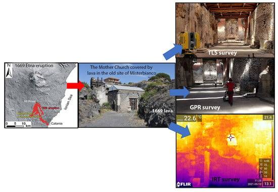
Misterbianco is a small but historically important town located on the southern slope of Mt. Etna (
Figure 1). Its position at the periphery of the volcano, alongside the Simeto river valley and dominating the fertile Catania plain, enabled the town to acquire a certain wealth and importance in the local territorial framework until the mid-17th century [
1,
2]. From then on, the old town of Misterbianco (known as
Monasterium Album, namely ‘white monastery’) underwent two natural catastrophes that heavily conditioned the history of this part of Sicily in the following centuries: the great 1669 Etna eruption and the huge/disastrous 1693 Val di Noto earthquake [
3]. With a lava field extending for 40 km
2 and a maximum flow length of 17 km [
3], the 1669 eruption greatly impacted the territorial setting of the southern flank of Mt. Etna. Lava buried dozens of villages and minor settlements, reached the city of Catania and finally entered into the sea. A large part of the architectural heritage was destroyed and the landscape after the eruption turned into a wasteland. After just two decades, the 1693 earthquake caused major destruction throughout south-eastern Sicily, again including Catania as well as many other localities of the southern flank of Etna [
4].
While the investigation of social and physical effects of ancient earthquakes is a widespread and well-consolidated discipline known as archaeoseismology [
5], in the case of volcanic eruptions, the conservation of ruins requires particular conditions. Where lava or pyroclastic flows tend to raze a building to the ground and to cover any remnants, tephra fallout often permits the conservation of artifacts. In such case, the branch of investigation referring to archaeological volcanology [
6,
7] indeed has a very long tradition; for instance, at Pompei (Mt. Vesuvius) to mention the most famous case-history in Italy.
The recovery of memory of the architectural heritage hit by events in the early modern period is, nevertheless, a prominent and rather difficult cultural operation. As regards Sicily and the two above-mentioned catastrophes, the ruins of the ghost towns destroyed by the 1693 earthquake have almost disappeared [
8], while the few remnants documenting the 1669 eruption are not adequately exploited, though they represent uncommon examples of heritage conservation beneath a lava flow (
Figure 1a). The Sanctuary of Mompilieri and the Chiesa Madre (Mother Church) of the old Misterbianco (
Figure 1b) are the most outstanding evidence of this architectural heritage brought to light through excavations [
9]. The Mompilieri site, located a few hundred meters south of the 1669 eruption’s main vent, was discovered in the early 1700s [
10]: the church was completely buried beneath 15 m thick lava, whose access was through a staircase excavated in the basalt rock. In the old site of Misterbianco, the situation was completely different: here, the steep original morphology determined zones with limited lava thickness; as a result, the bell tower of the church was the only still-standing portion in the lava field, hereinafter named Campanarazzu (
Figure 2a).
In this site, the excavation works were started in the 2000s by the Soprintendenza per i Beni Culturali e Ambientali (Cultural and Environmental Heritage, Dept. of Catania) and enabled unearthing the remains of the Mother Church (
Figure 2b–e), while a careful restoration plan reinforced the structure and recovered the remains of the chapel’s ornaments [
11,
12]. Notwithstanding the exceptionality of the archaeological evidence and the importance of the 1669 eruption in the social context of the territory, from geological and geophysical standpoints, little attention was paid to the fascinating site of old Misterbianco.
In this paper, we present the first diagnostic multidisciplinary study focusing specifically on the Mother Church building, aimed at (i) defining the spatial relation of the church’s structure with the 1669 lava field (
Figure 2c); (ii) identifying possible hidden features inside the edifice; (iii) reconstructing the historical evolution of the original building. To this end, firstly we made a drone survey to map the investigated area in detail, which was difficult to describe without an aerial view and was impossible to do by simply standing on the rough lava surface; we then used different diagnostic techniques such as ground-penetrating radar (GPR) to uncover buried crypts below the paved floor, infrared thermography (IRT) and terrestrial laser scanner (TLS) to detect previous structural modifications and deformation of architectural elements caused by the thrust and weight of the 1669 lava flow.
2. The 1669 Eruption
In the frame of the historical eruptions of Etna, which includes a period of about 2500 years [
13], the event of 1669 represents the largest flank eruption documented in historical times that caused the most damage to cultivated areas and settlements in the Etna region [
3,
14,
15]. During this eruption, which lasted four months from 11 March to 11 July, about 600 million m
3 of lava were erupted, with an average effusive rate of 58 ± 10 m
3/s, which finally produced a vast lava field covering an area of 40 km
2 on the southern flank of the volcano (
Figure 3a; for details, see [
16]). The development of a complex lava tube network promoted lava field lengthening as far as the coastline, destroying several villages and partially damaging the western part of the city of Catania [
15,
16]. As with many other flank eruptions at Etna, the 1669 one was accompanied by an intense seismic swarm that repeatedly hit the whole southern sector of the volcano [
3].
Briefly, the eruption originated from an eruptive fissure system, trending NNW-SSE, located west of the village of Nicolosi, at an altitude between 950 m and 700 m a.s.l. The main eruptive vent formed at 850–775 m a.s.l. and was preceded by several earthquakes producing very localized effects of heavy damage in Nicolosi and its surroundings. The prolonged and intense explosive activity generated the large scoria cone of Mts. Rossi, known at that time as
Monti della ruina (namely ‘mounts of ruins’). During the first two days of eruption, the seismic activity drastically decreased both in the number and energy of the shocks, while the effusion rate rapidly increased to around 640 m
3/s, producing a lava field that divided into two branches around the morphological barrier of the Mompilieri cone and covered an area of about 4 km
2, destroying the villages and small settlements located in the upper part of the southern flank of Etna (
Figure 3a). Fortunately, we could say, the earthquakes forced people to leave their homes, which ‘served’ to initiate evacuation of areas which were subsequently buried by the lava. After two weeks (11–25 March), the lava field covered 72% of its eventual total area and 42% of the total volume of lava had been emitted at this stage of the eruption. In this period, the three branches of the lava field destroyed many other villages and large areas of cultivated lands, reaching a maximum length of 10 km. In the last days of March, the central branch reached the Carcarazza district, about 1 km north-west of the old site of Misterbianco, and finally invaded the town on 30 March at a distance of 8.6 km from the eruptive vent.
According to the historical sources [
15], the town was almost totally covered by two lava flows. One caused the destruction of the main square area, while the other passed around the Mother Church area. The latter channeled onto steep terrains, damaging houses and buildings and finally reaching the church of San Nicolò at the southeastern tip of the settlement. Initially, the Mother Church and about 200 houses remained intact because of their elevated topographic position, but later, the emplacement of other lava flows completely covered this part of the town, leaving only the top of the bell tower standing out from the huge lava field. No damage caused by the seismic activity was reported for Misterbianco, where earthquakes were nonetheless felt by the inhabitants. In April, this branch continued flowing and reached Catania.
In those months, the ephemeral vents fed by the numerous lava tubes led to the formation of new lava flows that developed in the Misterbianco territory, producing a gradual thickening of the lava field [
16]. As a result, the average thickness of the lava field reaches 21 m in a quarry located about 300 m northeast of the study area, consisting of a basal flow unit characterized by a maximum thickness of 14 m (
Figure 3b) that is superimposed by several flow units with thickness ranging from 1.5 m up to 4 m. Overall, the morphology of the lava field consists of toothpaste lavas, often appearing fractured and tilted [
17], with the presence of several ephemeral vents and small tumuli (
Figure 3c).
3. The Ancient Settlement of Misterbianco and the Chiesa Madre: Historical Background
The reconstruction of the historical events marking the evolution of the ancient settlement of Misterbianco before its destruction in 1669 is reported by some authors [
11,
18]. Briefly, the old site was located on the southern slope of Mt. Etna at about 213 m a.s.l., 7 km from the city of Catania (
Figure 2a), of which it represented one of the nine hamlets (
casali). Its position at the periphery of the volcano, alongside the Simeto river valley and dominating the fertile Catania plain, favored the urban growth testified by 11 churches—with the Mother Church and the San Nicolò as the main ones—and stately homes, with a population of about 3600 inhabitants [
2,
19]. After 1669, the new settlement of Misterbianco was rebuilt 3 km away from the old site, in a position to safeguard it from Etna’s eruptions.
The oldest document mentioning the Chiesa Madre (known as
Sancta Maria de Monasterio Albo) dates back to the 14th century; over time, the structure underwent modifications with the addition of new rooms, a central nave, new altars and chapels (
Figure 4a; [
11,
18,
20]. The original core of the church is the small quadrangular-shaped chapel decorated with small columns identified as the gothic chapel, later transformed with the addition of an apse dedicated to the Madonna. Today, the building features a Latin cross plan with a 26 m-long and 9 m-wide nave, along which there are eight altars (
Figure 4). The presbytery has a rectangular-shaped room with a pseudo-apse: it also has an entrance door on the left, which was closed off during the eruption with massive stones to prevent lava flowing into the church (see
Section 4.2). A smaller door located to the right gives access to the gothic chapel. Along the southern wall of the nave is the bell tower, the only original element standing out from the 1669 lava. For this reason, it became the symbol of the old settlement of Misterbianco, and since then was named by local people as
Campanarazzu.
4. Multidisciplinary Surveys
A diagnostic multidisciplinary survey was performed in the Mother Church site, including both the inside of the building and the environmental setting on a surface of ca. 10 ha (
Figure 5). The application of several remote sensing methods is required to set up a subsurface geological model depicting the actual ground features, starting from a detailed topographic survey of the area, which is covered by the 1669 lava flow, together with the well-known techniques of surface prospections used in the archaeological field to investigate buried structures [
21,
22]. In general, the integration of different methods allows definition of the geometry of walls and detection of voids inside the structures [
23,
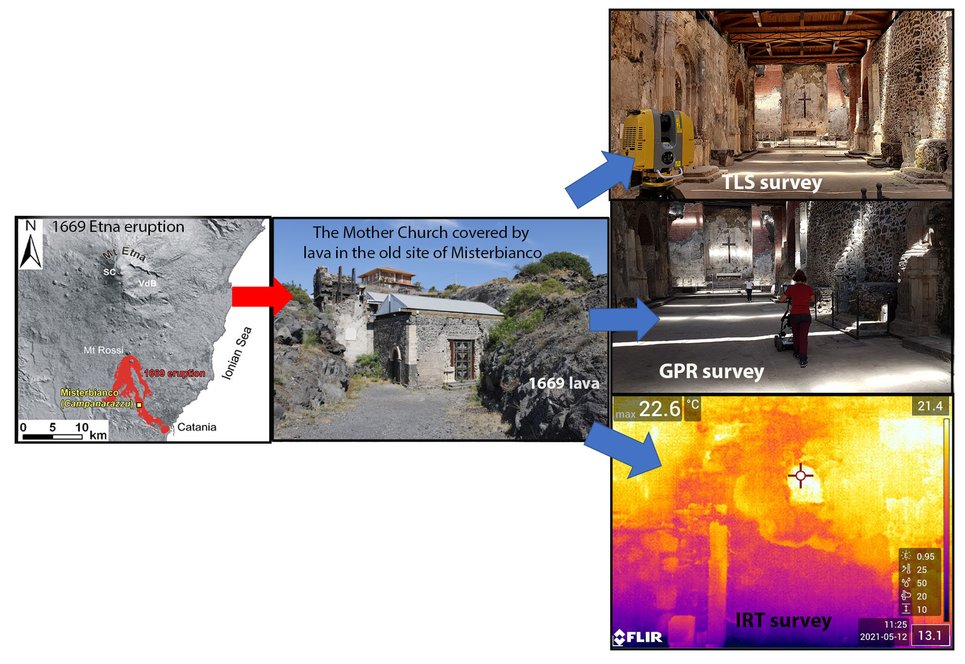
24]. The efficiency of the geophysical methods depends on the contrast between the physical properties of the material filling the cavity and those of the host material: the greater the contrast, the more effective the result. For this study, we applied the following four different methods: (i) aerial photogrammetry by drone to obtain a high-resolution mapping of the studied site within the 1669 lava flow; (ii) ground-penetrating radar (GPR) to detect voids below the church floor related to buried structures (i.e., tombs, crypts, etc.); (iii) a terrestrial laser scanner (TLS) to recognize fractures and deformations in structural and architectural elements; (iv) infrared thermography (IRT) to identify modifications before the 1669 lava flow not reported in the historical documents.
4.1. Structure-from-Motion Aerial Photogrammetry
The use of drones for aerial surveys provides new opportunities for topographical mapping, given the rapidity, low cost, and ultra-high resolution achievable [
24]. Among the possible applications, photogrammetry is a very effective and useful tool in all the fields, including archaeological and volcanological investigations [
25,
26].
The aerial photographic survey of the Misterbianco site produced a high-resolution digital surface model (DSM) and an orthophotomosaic by using the Structure-from-Motion technique (SfM). About 540 aerial images were acquired using a DJI Phantom 4 ProV 2.0, equipped with a 1″ CMOS 20 MP sensor and a 24 mm (35 mm equivalent) focal length lens with a double-grid flight path and nadir to off-nadir camera angles. A constant flight altitude of about 50 m above ground level was maintained and images were acquired via a dual grid flight plan with 75% front and 75% side overlap. The flight altitude was fixed to obtain a ground sampling distance (GSD) of 1.5 cm/pixel.
Aerial images were processed using Agisoft MetaShape
® software (version 1.6.3, Agisoft LLC, St. Petersburg, Russia) based on SfM and multi-view stereo photogrammetry algorithms (SfM-MVS; [
27]). The photogrammetric acquisition entailed the following steps: (i) identification of key points and image matching followed by scattered point cloud; (ii) filtering of the scattered point cloud, thus deleting incorrect geometry of those points characterized by significant coupling errors; (iii) generation of the dense point cloud; (iv) generation of the digital surface model (DSM) and of the orthophotomosaic.
The coordinates of a set of ground-control points were also acquired with a GNSS system in Real-Time Kinematic (RTK) mode, in order to georeference and scale the point cloud obtained with the SfM technique. As a result, the DSM and the orthophotomosaic are characterized by a spatial resolution of 10 cm/pixel and 5 cm/pixel, respectively, for the whole area of about 10 ha (
Figure 1).
4.2. Terrestrial Laser Scanner
Laser scanning enables a large quantity of three-dimensional measurements to be collected in a short time. It generates a point cloud in a local coordinate system with intensity values; additional information such as RGB values is usually provided by internal or external digital cameras. While the point cloud generated by laser scanning may be useful on its own, it is usually only a means to an end. Laser scanning is generally used to record surface information in order to generate 2D sections, profiles and plans, and 3D models.
TLS might be classified according to its range of measurements or its principle of operation: time-of-flight (TOF) or phase shift (PS). TOF scanners, such as the one used in this study, are suitable for long-range measurements, such as topography and mining, but they can also be successfully used for shorter ranges (e.g., architectural heritage, civil engineering). In contrast, TLS measurements based on PS technology can usually be taken faster, more accurately, and with a shorter range than TOF scanners [
28].
Scanners also have minimum and maximum ranges over which they can operate. These ranges depend on the manufacturer, and thus the selected device is crucial to properly record the studied site and/or object.
In recent years, TLS has been used with good results in volcanic environments, both for the study of lava flows [
29,
30] and in the field of cultural heritage for the characterization of historic buildings [
31,
32] or archaeological investigations [
33].
An initial TLS survey was performed in the Mother Church [
11] with a Leica HDS 3000 scanner (Leica Geosystems, Cyra Technologies, San Ramon, CA, USA) shortly after excavation works in order to enhance the knowledge of architectural heritage at Misterbianco.
After a few years, a new TLS survey aimed at detecting the fractures and deformations caused by the 1669 eruption or the 1693 earthquake was acquired (
Figure 6). The TLS survey of the Mother Church was performed through the integrated use of laser scanning and photogrammetric technologies in order to acquire geometric and spatial data of the historical heritage. As such, it provided a 3D database that describes the surface of the building, recording information on the characteristics of the materials and their state of preservation. For this purpose, we used a TOPCON GLS-2000S scanner (Topcon, Tokyo, Japan), featuring a maximum distance of 130 m, with field angles of 360° (horizontal) and 270° (vertical). This scanner (sensor) has a high resolution, namely up to 4 mm at 20 m distance. The survey was performed from outside to inside the building with 11 scans—three external and eight internal—in a Traverse or Polygonal mode (
Figure 6), aligned through a survey prism in order to optimize the data acquisition of the whole building. The scans were processed by using Magnet Collage Software (3D Point Cloud Processing Software; Topcon
® 2021, Magnet Collage Software version 2.7.12, Topcon, Tokyo, Japan) on Windows platform as a metric reference for subsequent modeling. This method allowed the precise placement of the external and the internal data of the building, avoiding cloud alignment operation in the post-processing phase.
Additionally, the possibility of linking the acquired data through a precise constrained topographic polygon, as well as the constitution of a network of scans for the point clouds at the end of the survey, thus enabled an alignment of data even though there are no common elements.
The 3D model of the church was obtained through overlapping TLS oriented scans with photogrammetry georeferenced on local coordinates.
Figure 6 reports some of the most important phases of TLS acquisition from the survey to the 3D model obtained.
4.3. Ground Penetrating Radar
Ground-Penetrating Radar technology (GPR) is a geophysical method based on the propagation of suitably generated electromagnetic pulses that can be reflected or diffracted by dielectric discontinuities in the ground [
34,
35]. GPR is probably the most common technique in the archaeological field for its ability to detect the subsurface structure with a good resolution, to reconstruct 3D models, and because it is non-invasive and non-destructive and hence easily applied in a wide range of situations [
36,
37,
38]. Recently, some studies have shown how GPR can be successfully used on lava soils [
39], also proving effective at identifying voids such as lava tubes [
40,
41,
42] or tombs [
43]. This geophysical method uses electromagnetic waves, typically in the 10–3000 MHz frequency range, to identify structures underground or inside walls [
44,
45] or to check the structural conditions of buildings and monuments with quick data acquisition and high resolution [
46,
47,
48,
49]. In archaeological investigations [
47,
50,
51,
52], it is a useful and effective tool to obtain information on the position of settlements and plan future excavations [
53,
54].
The GPR survey inside the church was aimed at collecting data on the presence of unknown structures, chambers, and tombs under the floors of the church and the crypts. For this research, the GPR survey was performed using a RIS MF HI-MOD system (IDS GeoRadar s.r.l.), equipped with an array of a multifrequency antenna (200–600 MHz). The antennas have been selected according to the resolution and depth of investigation; therefore, we used both antennas simultaneously, the first one to get a good superficial resolution and the other one to get a suitable depth. The measurements were carried out along parallel profiles through the nave of the church, which is 7.5 wide and 25.5 m long. On the whole, 15 profiles were acquired and 0.5 m spaced (
Figure 7a). Data were collected using the reflection technique, namely keeping the two antennas in a fixed configuration next to each other, moving them together on the ground in order to visualize a two-dimensional section (georadar profile) that shows the acquired signals side by side along the horizontal axis and the temporal variation of the received signal on the vertical axis. In the georadar section, the amplitudes of the signal are rendered with a chromatic scale.
During the survey, acquisition ranges of 50 ns for the 600 MHz antenna and 100 ns for the 200 MHZ antenna were used. The investigation depths were estimated considering an average velocity of electromagnetic waves of about 0.08 m/ns, obtained from the curvature of the reflection hyperbolas. The maximum depth of investigation reached is about 2 m for the data acquired with the 600 MHz antenna, and about 4 m for those acquired with the 200 MHz antenna. An example of a 2D GPR profile, acquired with both frequencies (200 MHz and 600 MHz), is shown in
Figure 8. In this profile, three shallow hyperbola are evident that have been correlated to the trapdoors in the pavement. Deeper reflections (z > 2 m), with lower reflectivity, are evident in the 200 MHz profile, probably due to boundaries between previous lava flows [
40].
Data elaboration was performed with Reflex software [
55] to obtain 2D envelopes of the migrated GPR profiles. To construct a 3D model of reflectivity of subsoil, we used a time-slice technique, which consists of the construction of horizontal sections at certain reflection times (time slices) or depths (depth slices) [
56]. The depth slices were generated using a code implemented in Matlab and the 3D model of the subsoil was represented using Voxler (Golden Software). The first two meters of the 3D model were obtained using the data acquired with the 600 MHz antenna, while up to four meters deep, the data acquired with the 200 MHz antenna were considered.
The 3D reflectivity model was geo-referenced with the plan of the church.
Figure 7b shows a view from the top of the reflectivity model superimposed on the plan. It can be seen that the locations of the high reflectivity anomalies often coincide with those of the tombstones, indicating the presence of numerous burials immediately below the paved floor of the church.
The shape and position of the main anomalies are more clearly defined in the 3D rendering model (
Figure 9). The smaller anomalies are located on the right side of the nave and have fairly regular shapes with horizontal dimensions of ca. 1 × 2 m. These anomalies are probably caused by burial chambers whose trapdoor is no longer visible. The largest anomalies are on the left side of the nave, near the altar area, and have elongated shapes. Their size could suggest that they are crypts, with a maximum height of about one meter, as observed in the vertical sections of the 3D model (
Figure 9b).
4.4. Infrared Thermography
Infrared thermography (IRT) is a non-destructive and non-invasive diagnostic technique used for the protection and safeguarding of architectural heritage. The thermographic survey detects humidity and lesions and identifies hidden architectural elements and detachments in the plaster [
57,
58]; in general, it allows assessment of the state of conservation or degradation of the materials, and recognition of the presence of different materials in the same wall structure [
59].
The physical principle is based on the emission of electromagnetic radiation in the infrared band (IRT) with wavelengths between 700 nm and 1 mm, in relation to the temperature of the analyzed body. The diagnostic imaging technique allows us to detect the surface temperature of the analyzed body and visualize both absolute values and temperature variations. The relationship between the temperature of the measured body and the amount of infrared radiation emitted from its surface is governed by a relationship of direct proportionality defined by the Stefan–Boltzmann law: E = σ · ε · T4, where E is emittance in the infrared band (IR), the power emitted per unit area (Watt per square meter W m
−2), σ is the Stefan–Boltzmann constant, ε represents the material emissivity, i.e., fraction of energy radiated by material with respect to the energy radiated by a black body that is at the same temperature and T is the absolute body temperature, measured ° K degrees [
57,
58,
59].
The thermographic survey of the Mother Church was carried out by using a Flir T 530 thermal imaging camera, operating in the spectral band 7.5–14.0 µm, and with a resolution of 320 × 240 pixels, accuracy ± 2 °C, thermal sensitivity/NETD < 40 mK, (from 24 °C to +30 °C). The photographic camera was equipped with infrared (IR) radiation sensors and with a 24 ° lens (FOV 24° × 18°). The measurement scale used is between −20 °C and 120 °C: the camera acquires the infrared radiation emitted from the investigated body and produces a false color image (from blue to red as the temperature increases). The color scale provides an immediate indication of the detected temperature. The thermographic analysis was carried out on the wall surface as it appeared, in conditions of normal thermal operation. The investigated walls of the church are the southern one, located between the bell tower and the Crocifisso altar (
Figure 10e), and the western one corresponding to the presbytery (
Figure 10a,b,e). The northern wall was not examined as it was heavily damaged during the excavation works and then reconstructed. The thermography is a surface survey that works well in the case of plaster less than 5 cm thick; for greater thickness, it is not possible to determine the wall texture. In the Mother Church, the thermographic images captured the most common lithotypes used in the area (lime, mortar and volcanic rock;
Figure 10). The thermographic signal detected a significant difference in the temperature among materials. For this reason, it was not only possible to analyze wall textures covered by the plaster, but also to distinguish between the different lithotypes used in the masonry. Furthermore, the images highlighted the presence of a probable wall structure under the plaster. This structure was identified due to the different thermal response between the filling and the surrounding masonry.
5. Discussion
The integration of historical and volcanological data with the results of multidisciplinary investigations performed in the old settlement of Misterbianco has allowed clarification of the effects of the 1669 lava flow in the Mother Church site, thus improving knowledge on the edifice before its destruction and capturing an image of the current state of the structure. In particular, the diagnostic investigations made inside the church revealed some structural characteristics or elements (e.g., crypts), and highlighted architectural modifications occurring over the centuries (i.e., patched walls).
By analyzing the lava field structure, it may be presumed that the church underwent two main phases of lava flow impact. In the first one, dated to the end of March, the basal lava flow initially surrounded the northern and western part of the edifice with a lava front some dozens meters thick; inhabitants, aware of the risk, blocked the southern entrance door of the presbytery with stones to prevent lava entering into the edifice (
Figure 6c). In the first moment, the northern and western walls were weakened by the lava thrust, fed by a high effusive rate of 130 m
3/s [
16], and shortly after they were knocked down, causing the roof to collapse.
The impact of the second phase, between May and June, is related to the evolution of the lava flow field, with the development of lava tunnels, ephemeral vents and spilling of toothpaste flows (
Figure 3c) that gradually covered the site. The low effusion rate of the toothpaste flows, a few meters thick, gradually filled the church’s nave, destroying the wooden roof remains but preserving the paved floor, and burnt the lime of the altars (
Figure 6d).
On observing the internal part of the church through the results of GPR, IRT and TLS surveys, it was possible to identify some structural modifications the edifice underwent before its destruction.
The IRT technique highlighted an anomaly in the presbytery wall due to the different thermal response between the filling and the surrounding masonry; no other anomalies were detected. Unfortunately, this structural modification cannot be constrained to a precise time interval due to the lack of documentary materials.
The GPR survey performed through the nave allowed recognition of the crypts below the paved floor; some anomalies are clearly located in correspondence of the trapdoors visible along the nave, thus clearly determining positions and dimensions. At the same time, the GPR reflections enabled verifying the crypts’ status: they seem to be intact and still empty without lava.
The TLS survey provided an accurate picture of the fractures and deformations inside the church: the most damaged portion is the altar area, where the fractures are almost vertical and the original wall is still preserved for more than 1 m. By comparing our TLS results with those of a previous study [
11], we note that they are in good agreement, being based on the same technology of measurements (TOF), but have significant differences in terms of accuracy and precision. Furthermore, other fractures are recognized in the lintel door of the bell tower (
Figure 6g,h) and in the Madonna delle Grazie altar. However, it is not possible to identify the original cause of the damage since the use of bulldozers in the excavations worsened the original setting of the site to some extent.
In conclusion, the above-mentioned observations confirm that lava did not damage the lower part of the church, namely the foundations, crypts and paved floor. However, the walls reacted in an entirely different way; firstly, the lava weakened the northern and western walls, and shortly after it entered from the roof. The reconstruction interventions made by the restoration plan are consistent with our results (
Figure 4e).
6. Conclusions
This paper presents the first multidisciplinary study on the Mother Church of the old settlement of Misterbianco, which was completely buried beneath the lava flow of the 1669 eruption. Investigating archaeological evidence of cultural heritage in a volcanic environment is not an easy task, both due to the very few existing cases and the operational difficulties of performing diagnostic investigations. The approach we proposed in this work may represent a pilot study for such a situation, where the integration of historical and volcanological data with different diagnostic techniques is fundamental for a correct interpretation.
Although the multidisciplinary survey has provided interesting results in terms of anomalies, it cannot be considered exhaustive. The choice of these techniques was indeed steered by the targets and funds of the project, which hindered the use of other geophysical methods, such as the geoelectrical surveys (the low electrical resistivity contrast between the air present in the crypts and the highly resistive lava prevented injecting a sufficiently high current through the brick floor of the church).
Results from the diagnostic investigations are consistent with the events reconstructed from historical information and volcanological field data. The effects of the lava flow—particularly thrust, weight and heat—heavily damaged the masonry of the remaining perimetric walls, though the ruins still preserved some elements (altars, ornaments and flooring) until the excavations. Nevertheless, first the excavation works and then the massive roof added to preserve the interior of the church have severely weakened the structure of the building.
The crypts found beneath the floor and the structural modification of the wall behind the altar area deserve further investigation, both of a geophysical nature and small excavation tests. However, the results of these diagnostic multidisciplinary investigations represent useful benchmarks for future analyses, as well as for monitoring the state of conservation of the Mother Church.


 ,
, 


