
A Geomatic Approach to the Preservation and 3D Communication of Urban Cultural Heritage for the History of the City: The Journey of Napoleon in Venice


Abstract
:
1. Introduction
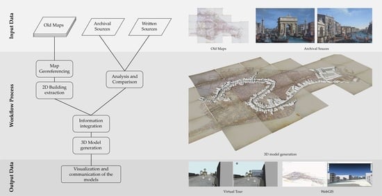
2. Materials and Methods
2.1. Representing the City’s History through Historical Maps and Drawings
2.1.1. The Integration between Historical Maps and GISs
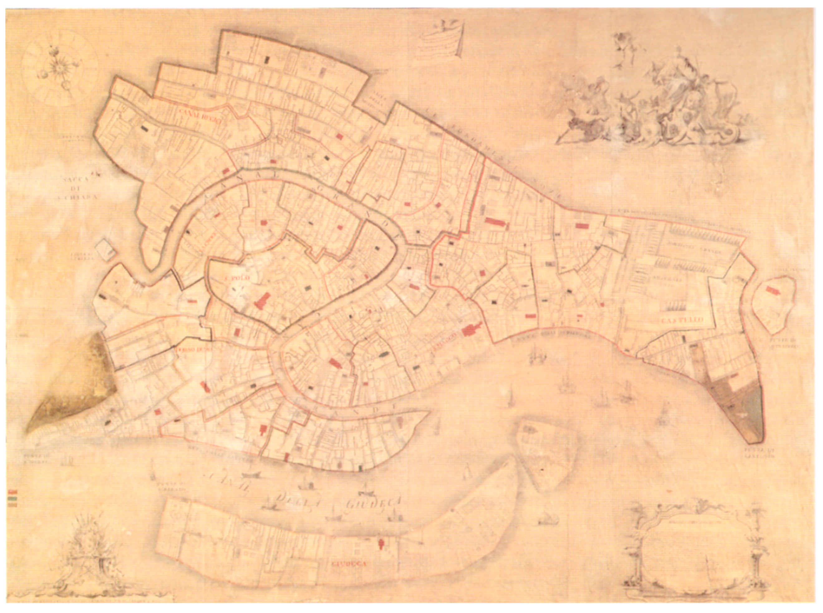
2.1.2. The Analysis of Napoleonic Cadastre through an HGIS
2.2. From Historical Maps to City Models
2.3. Reconstructing Ephemeral Architectures
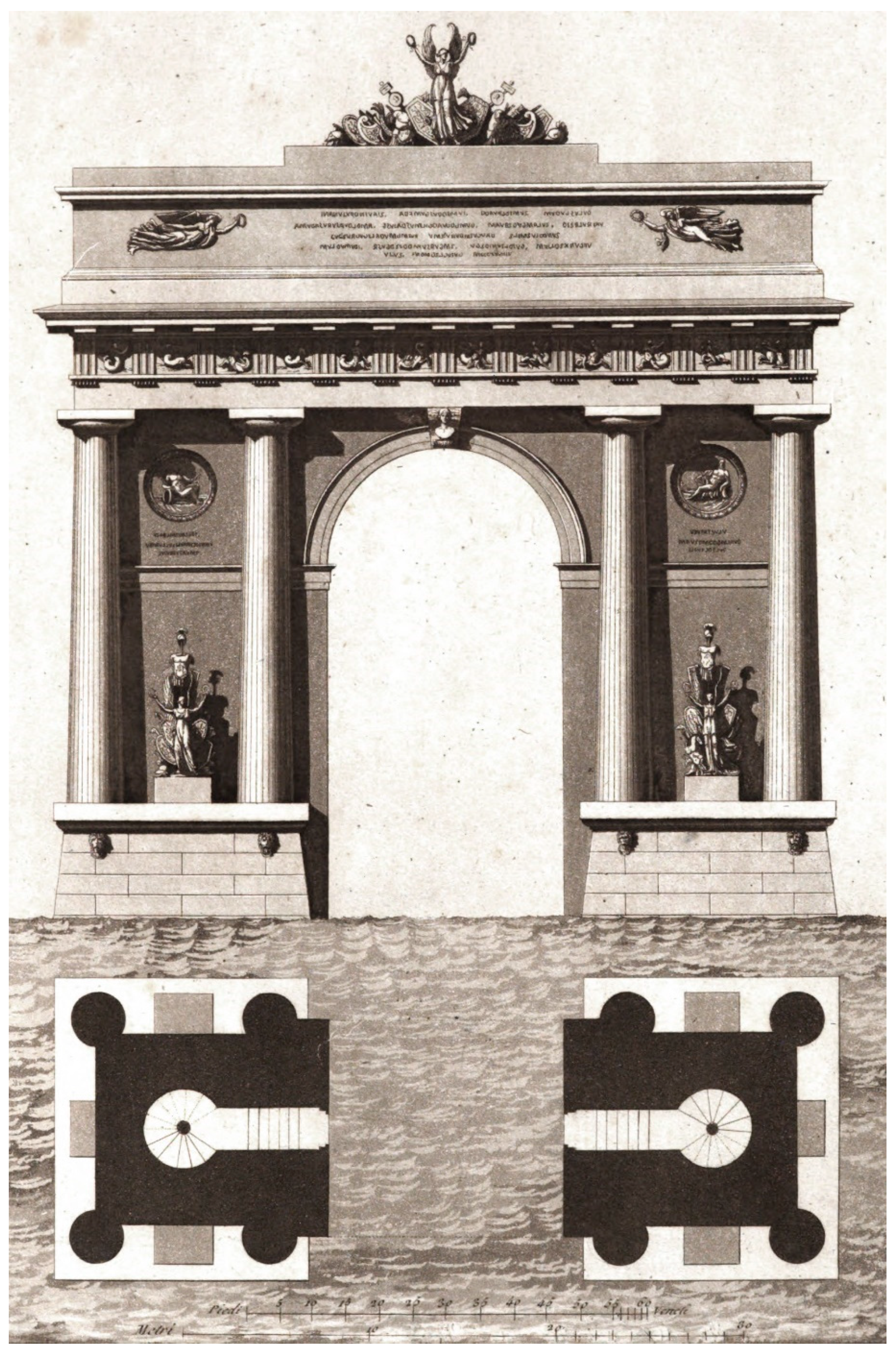
2.3.1. The Triumphal Apparatus
2.3.2. The Relationship between the Triumphal Apparatus and the City
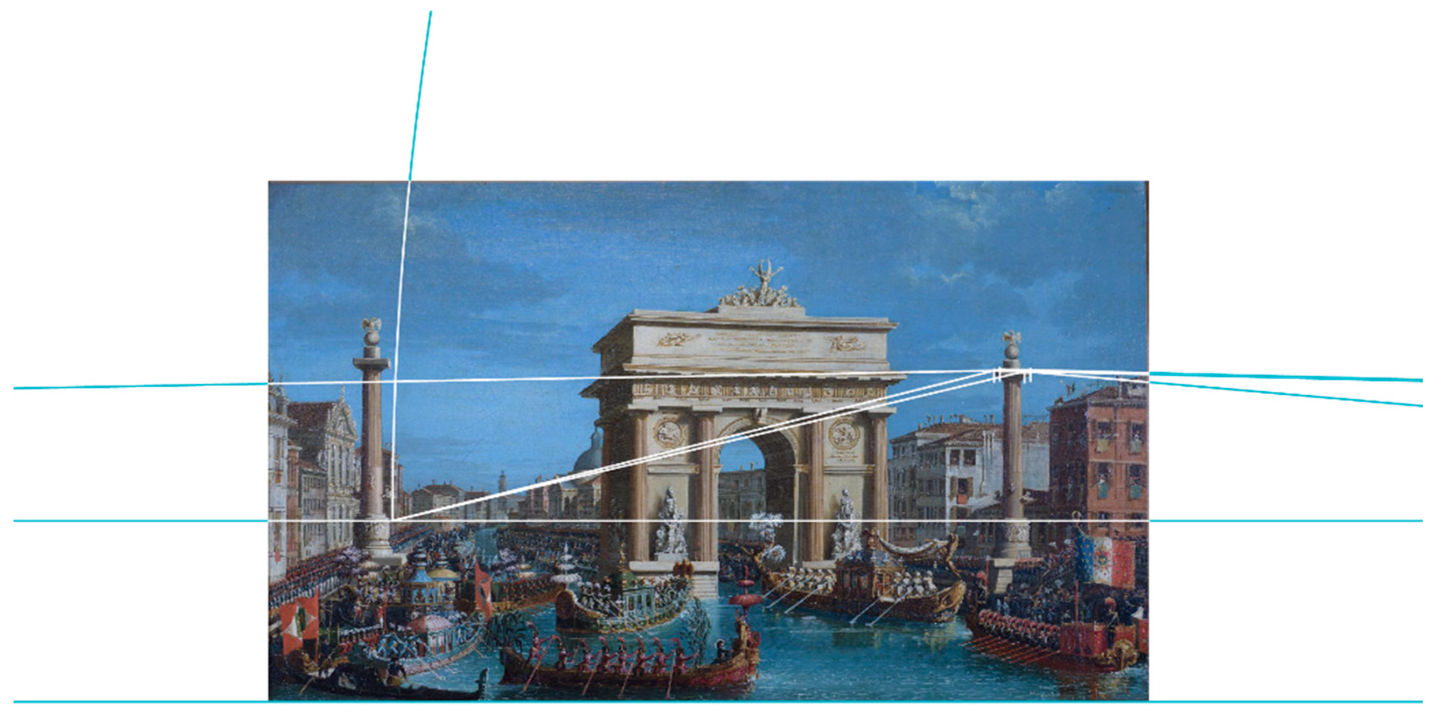
2.3.3. The Inverse Method of Perspective
2.3.4. Using Old Paintings to Recover the Geometric Parameters of the Perspective of the Image
2.3.5. The Relationship between the Real City and the City Shown by the Paintings
2.3.6. The Grandstand for the Regatta
2.3.7. The Relationship between the Grandstand and the City
3. Results: The Use of Online Portals for Urban Cultural Heritage Knowledge and Conservation
3.1. The Virtual Tour
3.2. The WebGIS
4. Conclusions
Author Contributions
Funding
Conflicts of Interest
References
- Rinaudo, F.; Eros, A.; Ardissone, P. Gis and Web-Gis, Commercial and Open Source Platforms: General Rules for Cultural Heritage Documentation. In Proceedings of the 21st CIPA Symposium AntiCIPAting the Future of the Cultural Past, Athens, Greece, 1–6 October 2007. [Google Scholar]
- Balletti, C. Digital Elaborations for Cartographic Reconstruction: The Territorial Transformations of Venice Harbours in Historical Maps. e-Perimetron 2006, 1, 274–286. [Google Scholar]
- Piumatti, P.; Tamborrino, R.R. 3D Digital Modelling and Digital History: A Methodology for Studying the Processes of Transformation of Nubian Temples and Landscape at the Lake Nasser Site. In Proceedings of the 45th Conference on Computer Applications and Quantitative Methods in Archaeology, Atlanta, GA, USA, 14–16 March 2017; Tübingen University Press: Atlanta, GA, USA, 2017; pp. 381–392. [Google Scholar]
- Balletti, C.; Guerra, F. Historical Maps for 3D Digital City’s History. Cartogr. Int. J. Geogr. Inf. Geovis. 2016, 51, 115–126. [Google Scholar] [CrossRef]
- Pepe, M.; Costantino, D.; Alfio, V.S.; Restuccia, A.G.; Papalino, N.M. Scan to BIM for the Digital Management and Representation in 3D GIS Environment of Cultural Heritage Site. J. Cult. Herit. 2021, 50, 115–125. [Google Scholar] [CrossRef]
- Tamborrino, R.R.; Rinaudo, F. Sharing Knowledge, Grasping Cultural Heritage: A Digital Multidisciplinary Approach to the Historical Process of Architecture and Urban Changes. In Heritage and Technology. Mind, Knowledge, Experience, Proceeding of the XIII International Forum ‘le Vie dei Mercanti’ Aversa and Capri, Lecce, Italy, 11–13 June 2015; La scuola di Pitagora Editrice: Napoli, Italy, 2015; pp. 1261–1270. [Google Scholar]
- Dewitz, L.; Kröber, C.; Messemer, H.; Maiwald, F.; Münster, S.; Bruschke, J.; Niebling, F. Historical photos and visualizations: Potential for research. Int. Arch. Photogramm. Remote Sens. Spat. Inf. Sci. 2019, XLII-2/W15, 405–412. [Google Scholar] [CrossRef] [Green Version]
- Einaudi, D.; Spreafico, A.; Chiabrando, F.; della Coletta, C. From archive documentation to online 3d model visualization of no longer existing structures: The turin 1911 project. Int. Arch. Photogramm. Remote Sens. Spat. Inf. Sci. 2020, 43, 837–844. [Google Scholar] [CrossRef]
- Lelo, K. A GIS Approach to Urban History: Rome in the 18th Century. ISPRS Int. J. Geo-Inf. 2014, 3, 1293–1316. [Google Scholar] [CrossRef] [Green Version]
- Gatta, G.; Arioti, E.; Bitelli, G. Geomatics Science Applied to Cartographic Heritage and Archive Sources: A New Way to Explore the XIXth Century Gregorian Cadastre of Bologna (Italy), an Ante-Litteram 3D GIS. J. Cult. Herit. 2017, 23, 68–76. [Google Scholar] [CrossRef]
- Balletti, C.; Galeazzo, L.; Gottardi, C.; Guerra, F.; Vernier, P. New Technologies Applied to the History of the Venice Lagoon. In Digital Approaches to Cartographic Heritage, Proceedings of the 11th ICA Conference, Macao, China, 11–14 May 2021; Livieratos, E., Ed.; CartoGeoLab-Laboratory of Cartography & Geographic Analysis: Thessaloniki, Greece, 2016; pp. 182–190. [Google Scholar]
- Chiabrando, F.; Sammartano, G.; Spanò, A.; Spreafico, A. Hybrid 3D Models: When Geomatics Innovations Meet Extensive Built Heritage Complexes. ISPRS Int. J. Geo-Inf. 2019, 8, 124. [Google Scholar] [CrossRef] [Green Version]
- Günay, S. Geographical information systems as a tool for 3d visualization of lost architectural heritage. ISPRS Ann. Photogramm. Remote Sens. Spat. Inf. Sci. 2019, 4, 69–75. [Google Scholar] [CrossRef] [Green Version]
- Baiocchi, V.; Lelo, K.; Milone, M.V.; Mormile, M.; Tanga, E. Conoscere Il Passato per Governare Il Presente: Un Confronto Tra Cartografia Storica e Moderna per Lo Studio Del Centro Di Roma. In Proceedings of the Atti 16a Conferenza Nazionale ASITA, Vicenza, Italy, 6–9 November 2012; pp. 99–106. [Google Scholar]
- Contò, F.; Fanello, G.; Pillon, M. An Information System for Historical Cadastre of Venice. e-Perimetron 2009, 4, 240–246. [Google Scholar]
- Grava, M.; Berti, C.; Gabellieri, N.; Gallia, A. Historical GIS. Strumenti Digitali per la Geografia Storica in Italia; Edizioni Università di Trieste EUT: Trieste, Italy, 2020. [Google Scholar]
- Gatta, G.; Bitelli, G. A HGIS for the Study of Waterways: The Case of Bologna as Ancient City of Waters. IOP Conf. Ser. Mater. Sci. Eng. 2020, 949, 12051. [Google Scholar] [CrossRef]
- Guidi, G.; Russo, M. Diachronic 3D reconstruction for lost cultural heritage. Int. Arch. Photogramm. Remote Sens. Spat. Inf. Sci. 2011, XXXVIII-5/W16, 371–376. [Google Scholar] [CrossRef] [Green Version]
- Balletti, C.; Galeazzo, L.; Gottardi, C.; Massaro, M.; Vernier, P. From Historical Maps to Digital Technologies: The Visualisation of the Venetian Ghetto’s History. e-Perimetron 2020, 15, 155–167. [Google Scholar]
- Gregory, I.N.; Healey, R.G. Historical GIS: Structuring, Mapping and Analysing Geographies of the Past. Prog. Hum. Geogr. 2007, 31, 638–653. [Google Scholar] [CrossRef]
- Gatta, G.; Bitelli, G. A Historical GIS for the Comparison of Past and Present Views: Bologna, Yesterday and Today. In Proceedings of the 11th ICA Conference “Digital Approaches to Cartographic Heritage”, Riga, Latvia, 20–22 April 2016; Livieratos, E., Ed.; CartoGeoLab—Laboratory of Cartography & Geographic Analysis: Salonicco, Greece, 2016; pp. 125–131. [Google Scholar]
- Spanò, A.; Chiabrando, F.; Dezzani, L.; Prencipe, A. Digital Segusio: From Models Generation to Urban Reconstruction. Virtual Archaeol. Rev. 2016, 7, 87–97. [Google Scholar] [CrossRef] [Green Version]
- Zucconi, G.V. Les Français À Venise: Ville et Architecture À l’époque Impériale (1806–1813). In Bâtir pour Napoléon. Un Architecture Franco-Italienne; Tedeschi, L., Garric, J.-P., Rabreau, D., Eds.; Éditions Mardaga: Brouxelles, Brussels, 2021; pp. 455–472. [Google Scholar]
- Romanelli, G. Venezia Ottocento. Materiali per Una Storia Architettonica e Urbanistica Della Città Nel Secolo XIX; Officini: Venezia, Italy, 1977. [Google Scholar]
- Romanelli, G. Venezia Ottocento: L’architettura, L’urbanistica; Albrizzi: Venezia, Italy, 1988. [Google Scholar]
- Bellavitis, G.; Romanelli, G. Le Città Nella Storia d’Italia—Venezia; Laterza: Roma, Italy, 1985. [Google Scholar]
- Panciera, W. Napoleone Nel Veneto: Venezia e Il Generale Bonaparte, 1796–1797; Cierre Edizioni: Sommacampagna, Italy, 2004. [Google Scholar]
- Gobbi, S.; Ciolli, M.; la Porta, N.; Rocchini, D.; Tattoni, C.; Zatelli, P. New Tools for the Classification and Filtering of Historical Maps. ISPRS Int. J. Geo-Inf. 2019, 8, 455. [Google Scholar] [CrossRef] [Green Version]
- Farella, E.M.; Özdemir, E.; Remondino, F. 4D Building Reconstruction with Machine Learning and Historical Maps. Appl. Sci. 2021, 11, 1445. [Google Scholar] [CrossRef]
- Gatta, G. Analisi Metrica Di Cartografia Antica in Ambiente Digitale. Boll. A.I.C. 2011, 141–142, 41–53. [Google Scholar]
- Grava, M. From the Archives to Web 2.0: The Use of GIS and WebGIS Applications in Industrial Archeology. IA. J. Soc. Ind. Archeol. 2012, 38, 5–18. [Google Scholar]
- Balletti, C. Georeference in the Analysis of the Geometric Content of Early Maps. e-Perimetron 2006, 1, 32–42. [Google Scholar]
- Balletti, C.; Boutoura, C. Revisiting the Projective Properties of Historic Nautical Maps of the Mediterranean and the Aegean. In Proceedings of the 20th International Cartographic Conference, Beijing, China, 6–10 August 2001; Scientific and Technical Program Committee: Beijing, China, 2001. [Google Scholar]
- Boutoura, C.; Livieratos, E. Some Fundamentals for the Study of the Geometry of Early Maps by Comparative Methods. e-Perimetron 2006, 1, 60–70. [Google Scholar]
- Jenny, B.; Weber, A.; Hurni, L. Visualizing the Planimetric Accuracy of Historical Maps with MapAnalyst. Cartographica 2007, 42, 89–94. [Google Scholar] [CrossRef] [Green Version]
- Pavanello, I.; Concina, E.; Trincanato, E.R. I Catasti Storici di Venezia: 1808–1913; Officina: Roma, Italy, 1981. [Google Scholar]
- Guerra, F.; Balletti, C.; Monti, C.; Livieratos, E.; Boutoura, C. Studi Ed Elaborazioni Informatiche e Infografiche Sulla Veduta Prospettica Di de’ Barbari. In A Volo D’uccello. Jacopo de’ Barbari e le Rappresentazioni di Città Nell’europa del Rinascimento; Romanelli, G., Biadene, S., Tonini, C., Eds.; Arsenale Editrice: Venezia, Italy, 1999; pp. 92–100. [Google Scholar]
- Lelo, K. L’ambito Urbano Di Piazza Navona: Una Interpretazione Attraverso le Fonti Cartografiche e Documentarie Sette-Ottocentesche. In “Piazza Navona, ou Place Navone, la plus belle & la plus Grande”. Du Stade de Domitien à la Place Moderne: Histoire d’une Évolution Urbaine; Bernard, J.F., Ed.; École Française de Rome: Roma, Italy, 2014; pp. 557–570. [Google Scholar] [CrossRef]
- Barzaghi, R.; Carrion, D.; Migliaccio, F.; Minini, G.; Zambrano, C. Strumenti GIS per Il Supporto Agli Studi Storici: Una Proposta per l’innovazione Dei Metodi Di Ricerca. In Proceedings of the Atti 16a Conferenza Nazionale ASITA, Vicenza, Italy, 6–9 November 2012; pp. 167–171. [Google Scholar]
- Carrion, D.; Migliaccio, F.; Minini, G.; Zambrano, C. Rappresentazione Cartografica e Condivisione di Dati Storici in Ambiente GIS. In Proceedings of the Atti 17a Conferenza Nazionale ASITA, Riva del Garda, Italy, 5–7 November 2013; pp. 379–384. [Google Scholar]
- Guerra, F. 2W new technologies for the georeferenced visualisation of historic cartography. In Proceedings of the XIX ISPRS Congress Volume XXXIII Part B5, Amsterdam, The Netherlands, 16–23 July 2000. [Google Scholar]
- Baiocchi, V.; Lelo, K. Georeferencing the Historical Maps of Rome between the Seventeenth and Eighteenth Centuries. In Proceedings of the CIPA 2005 XX International Symposium-International Cooperation to Save the World’s Cultural Heritage, Torino, Italy, 26 September–1 October 2005; pp. 114–118. [Google Scholar]
- Bitelli, G.; Gatta, G. Georeferencing of an XVIII Century Technical Map of Bologna (Italy). e-Perimetron 2012, 7, 195–204. [Google Scholar]
- Heitzler, M.; Hurni, L. Cartographic Reconstruction of Building Footprints from Historical Maps: A Study on the Swiss Siegfried Map. Trans. GIS 2020, 24, 442–461. [Google Scholar] [CrossRef]
- Nobajas, A.; Nadal, F. From Historical Map to Online 3D Recreation: The 1861 Cadastral Map of Horta (Barcelona). Cartogr. Geogr. Inf. Sci. 2015, 42, 211–223. [Google Scholar] [CrossRef] [Green Version]
- Harrie, L.; Kanters, J.; Mattisson, K.; Nezval, P.; Olsson, P.-O.; Pantazatou, K.; Kong, G.; Fan, H. 3D city models for supporting simulations in city densifications. Int. Arch. Photogramm. Remote Sens. Spat. Inf. Sci. 2021, XLVI-4/W4-2021, 73–77. [Google Scholar] [CrossRef]
- Li, R.Y.M. 5D GIS Virtual Heritage. Procedia Comput. Sci. 2017, 111, 294–300. [Google Scholar] [CrossRef]
- Dimitrov, H.; Petrova-Antonova, D. 3D city model as a first step towards digital twin of sofia city. Int. Arch. Photogramm. Remote Sens. Spat. Inf. Sci. 2021, 43, 23–30. [Google Scholar] [CrossRef]
- Kersten, T.P.; Keller, F.; Saenger, J.; Schiewe, J. Automated Generation of an Historic 4D City Model of Hamburg and Its Visualisation with the GE Engine; Springer: Berlin/Heidelberg, Germany, 2012; pp. 55–65. [Google Scholar] [CrossRef]
- Laycock, S.D.; Brown, P.G.; Laycock, R.G.; Day, A.M. Aligning Archive Maps and Extracting Footprints for Analysis of Historic Urban Environments. Comput. Graph. 2011, 35, 242–249. [Google Scholar] [CrossRef] [Green Version]
- Herold, H.; Hecht, R. 3D Reconstruction of Urban History Based on Old Maps. In Digital Research and Education in Architectural Heritage; Münster, S., Friedrichs, K., Niebling, F., Seidel-Grzesińska, A., Eds.; Springer International Publishing: Cham, Switzerland, 2018; pp. 63–79. [Google Scholar]
- Kolbe, T.H.; Gröger, G.; Plümer, L. CityGML: Interoperable Access to 3D City Models. In Geo-information for Disaster Management; van Oosterom, P., Zlatanova, S., Fendel, E.M., Eds.; Springer: Berlin/Heidelberg, Germany, 2005; pp. 883–899. [Google Scholar] [CrossRef]
- Colucci, E.; Abbate, E.; Mantello, F.; Sammartano, G.; Spanò, N. Approcci GIS Ed HBIM Integrati per l’analisi del Patrimonio Paesaggistico. In Proceedings of the Atti Conferenza Nazionale ASITA2019, Trieste, Italy, 12–14 November 2019; pp. 285–292. [Google Scholar]
- Baldin, C.M.; Casella, V.; Marchese, P. 3D City Models Dettagliati in Ambiente ESRI ArcGIS Pro: Una Prima Esperienza. In Proceedings of the Atti ASITA Academy 2021; pp. 15–26. Available online: http://atti.asita.it/ASITA2021/Pdf/044.pdf (accessed on 1 June 2022).
- Döllner, J.; Baumann, K.; Buchholz, H. Virtual 3D City Models as Foundation of Complex Urban Information Spaces. In Proceedings of the CORP 2006 & Geomultimedia06, Vienna, Italy, 13–16 February 2006. [Google Scholar]
- Morelli, J. Descrizione Delle Feste Celebrate in Venezia per la Venuta di S. M. I. R. Napoleone Il Massimo Imperatore de’ Francesi Re d’Italia Protettore Della Confederazione del Reno Data al Pubblico Dal Cavaliere Abate Morelli Regio Bibliotecario; Tipografia Picotti: Venezia, Italy, 1807. [Google Scholar]
- Beltrami, C.; Cavezzali, D.; Chiabrando, F.; Iaccarino Idelson, A.; Patrucco, G.; Rinaudo, F. 3D digital and physical reconstruction of a collapsed dome using sfm techniques from historical images. Int. Arch. Photogramm. Remote Sens. Spat. Inf. Sci. 2019, XLII-2/W11, 217–224. [Google Scholar] [CrossRef] [Green Version]
- Sgrosso, A. Note di Fotogrammetria Applicata All’architettura; Lithorapid: Napoli, Italy, 1979. [Google Scholar]
- Friso, I.; Liva, G.; Guidarelli, G. The “Ideal” City and the “Real” City Painted by Tintoretto. Disegnarecon 2018, 11, 6.1–6.14. [Google Scholar]
- Caroti, G.; Martinez-Espejo Zaragoza, I.; Piemonte, A. Accuracy assessment in structure from motion 3d reconstruction from uav-born images: The influence of the data processing methods. Int. Arch. Photogramm. Remote Sens. Spat. Inf. Sci. 2015, XL-1/W4, 103–109. [Google Scholar] [CrossRef] [Green Version]
- Baiocchi, V.; Onori, M.; Scuti, M. Integrated geomatic techniques for the localization and georeferencing of ancient hermitages. Int. Arch. Photogramm. Remote Sens. Spat. Inf. Sci. 2021, 46, 31–37. [Google Scholar] [CrossRef]
- Maté-González, M.Á.; Rodríguez-Hernández, J.; Sáez Blázquez, C.; Troitiño Torralba, L.; Sánchez-Aparicio, L.J.; Fernández Hernández, J.; Herrero Tejedor, T.R.; Fabián García, J.F.; Piras, M.; Díaz-Sánchez, C.; et al. Challenges and Possibilities of Archaeological Sites Virtual Tours: The Ulaca Oppidum (Central Spain) as a Case Study. Remote Sens. 2022, 14, 524. [Google Scholar] [CrossRef]


Publisher’s Note: MDPI stays neutral with regard to jurisdictional claims in published maps and institutional affiliations. |
© 2022 by the authors. Licensee MDPI, Basel, Switzerland. This article is an open access article distributed under the terms and conditions of the Creative Commons Attribution (CC BY) license (https://creativecommons.org/licenses/by/4.0/).
Share and Cite
Fiorini, G.; Friso, I.; Balletti, C. A Geomatic Approach to the Preservation and 3D Communication of Urban Cultural Heritage for the History of the City: The Journey of Napoleon in Venice. Remote Sens. 2022, 14, 3242. https://doi.org/10.3390/rs14143242
Fiorini G, Friso I, Balletti C. A Geomatic Approach to the Preservation and 3D Communication of Urban Cultural Heritage for the History of the City: The Journey of Napoleon in Venice. Remote Sensing. 2022; 14(14):3242. https://doi.org/10.3390/rs14143242
Chicago/Turabian StyleFiorini, Giulia, Isabella Friso, and Caterina Balletti. 2022. "A Geomatic Approach to the Preservation and 3D Communication of Urban Cultural Heritage for the History of the City: The Journey of Napoleon in Venice" Remote Sensing 14, no. 14: 3242. https://doi.org/10.3390/rs14143242
APA StyleFiorini, G., Friso, I., & Balletti, C. (2022). A Geomatic Approach to the Preservation and 3D Communication of Urban Cultural Heritage for the History of the City: The Journey of Napoleon in Venice. Remote Sensing, 14(14), 3242. https://doi.org/10.3390/rs14143242