Article

Evaluation of R Tools for Downloading MODIS Images and Their Use in Urban Growth Analysis of the City of Tarija (Bolivia)

by
Milton J. Campero-Taboada
1,
Eduardo Luquin
1,
Manuel Montesino-SanMartin
2,3,
María González-Audícana
1 and
Miguel A. Campo-Bescós
1,*
1
Department of Engineering, IS-FOOD Institute (Innovation & Sustainable Food Chain Development), Public University of Navarre, 31006 Pamplona, Navarre, Spain
2
Department of Statistics, Computer Science and Mathematics, InaMat2 Institute (Advanced Materials and Mathematics), Public University of Navarre, 31006 Pamplona, Navarre, Spain
3
SATLANTIS, Parque Científico UPV/EHU, 48940 Leioa, Basque Country, Spain
*
Author to whom correspondence should be addressed.
Remote Sens. 2022, 14(14), 3404; https://doi.org/10.3390/rs14143404
Submission received: 23 May 2022 / Revised: 10 July 2022 / Accepted: 11 July 2022 / Published: 15 July 2022

Abstract

:
The aim of this study was to compare the available tools in R for downloading and processing Moderate Resolution Imaging Spectroradiometer (MODIS) data, specifically the Enhanced Vegetation Index (EVI) product. The R tools evaluated were the MODIS package, RGISTools, MODISTools, R Google Earth Engine (RGEE) package, MODIStsp, and the Application for Extracting and Exploring Analysis Ready Samples (AppEEARS) application. Each tool was used to download the same product (EVI) corresponding to the same day (3 December 2015), and downloaded data were used to analyze the urban growth of Tarija (Bolivia) as an interesting application. The following features were analyzed: download time and memory used during the download, additional post-processing time, local memory occupied on the computer, and downloaded file formats. Results showed that the most efficient R tools were those that work directly in the “cloud” or use text queries (RGEE and AppEEARS, respectively) and provide, as a final product, a cropped.tif image according to the area of interest.

Graphical Abstract

1. Introduction

Satellite multispectral imagery is a valuable source of information for many applications, such as economic, hydrological or land management, and precision agriculture and environmental evaluations [1,2,3,4,5]. Among these applications, the earth surface monitoring of vegetation stands out as it directly impacts important processes, including biodiversity, ecosystem services, and climate change. Satellite imagery is ideal for vegetation monitoring because: (i) it provides recurrent and large-scale observations of the land surface [6], (ii) it can collect long time series, and (iii) it is provided by multiple free-satellite imagery data sources. The Moderate Resolution Imaging Spectroradiometer (MODIS) sensor is particularly useful as it provides frequent (daily) images with moderate resolution (250 m) for about 20 years. This valuable information is used for different applications, including elaborating large-scale crop classification maps [7] and analyzing the spatial distribution of vegetation and its temporal dynamics [8,9]. Multispectral layers are also used to calculate vegetation indexes to approximate vegetation vigorousness [10,11,12]. The NDVI (Normalized Difference Vegetation Index) and EVI (Enhanced Vegetation Index) are two widely used indexes.
Several tools are available for downloading and processing MODIS images. These tools include R software, a software environment for statistical analysis and graphics [13]. R has several advantages: (i) it is an open-source platform, (ii) it has multiple versatile libraries for image processing, (iii) it has the latest statistical analysis tools, (iv) it is a software widely distributed in the scientific community, and (v) it allows the automation of processes, reducing the risk of human error and the effort required by researchers to perform these tasks manually [14]. The tools available in R for image analysis require the information being locally available. Therefore, downloading the data can become one of the limitations of image analysis, especially with the increasing trend of analyzing large data volumes. There are multiple tools in R for MODIS data download. The most widely used are the following: MODIS [15], RGISTools [16], MODISTools [14], RGEE [17], MODIStsp [18], and the AppEEARS application [19]. These tools have been used in several applications, including ecological studies. For example, Tuck et al. [14] associate the spatial distribution of animal species with vegetation indices, and Militino et al. [20] use them to estimate water levels in reservoirs. Additionally, they have been used within third-party service platforms to preprocess the time series of MODIS vegetation indices [21]. According to Tuck et al. [14], the use of download tools simplifies access to data by reducing time-consuming and error-prone execution steps, thus increasing research efficiency. To our knowledge, there are currently no studies that systematically evaluate and compare these tools and the computing time and resources required. This would allow the end user to make a more informed decision when choosing the downloading tool that best suits their requirements and research needs.
The main objective of this study was to evaluate the available tools in R for downloading and processing MODIS data using the same benchmark based on criteria, including the download times and the memory used to obtain the desired images. As an example of the utilization of MODIS products in developing countries, this study explored the usefulness of downloaded data to analyze the urban growth in the city of Tarija (Bolivia).

2. Materials and Methods

2.1. MODIS

The Moderate Resolution Imaging Spectroradiometer (MODIS) sensor is on board two satellites, Terra launched in 1999, and the Aqua launched in 2002 [22]. MODIS has 12 bits of radiometric resolution and consists of 36 spectral bands in a wavelength range from 0.405 µm to 14.385 µm [23]. The spatial resolution depends on the bands, ranging from 250 m to 1 km [24]. The recorded data are divided into scenes or “tiles” with sinusoidal projection, covering an equivalent of 1200 km × 1200 km of the earth’s surface. This division is designed to facilitate data processing and exchange. In addition, MODIS has freely available products that have been extensively documented [11,22]. Some of these products have been used for the study of the ocean (MOcean), atmosphere (MODIS Atmosphere), and land surfaces (MODLAND) [25].
Within the MODLAND group is the MOD13Q1 product with two layers of vegetation indices: the NDVI (Normalized Difference Vegetation Index) and EVI (Enhanced Vegetation Index). Both indices have a temporal resolution of 16 days and a spatial resolution of 250 m. The NDVI—one of the most widely used vegetation indices—works with red and near-infrared bands. Thus, many sensors can calculate it. However, this index is influenced by the atmosphere and by the optical conditions of the soil [10]. In addition, it is also more sensitive than others to chlorophyll and saturates at high biomass levels [7,11,26]. EVI [8,27] is another widely used vegetation index which overcomes the limitations of the NDVI [11]. EVI provides improved sensitivity for areas with dense vegetation and minimizes the influence of soil and atmosphere by including the blue band within its equation [7,10,28]. The EVI index works with the red, blue, and near-infrared bands as described below:
E V I = G ρ N I R ρ R E D ρ N I R + L + ( C 1 ρ R E D C 2   ρ B L U E )
where: G is the gain factor, ρNIR, ρRED, and ρBLUE correspond to the reflectances in the NIR, red, and blue bands, L′ is the background adjustment (differential radiative transfer of NIR and red), and C1 and C2 are the aerosol effect correction coefficients. The most commonly used values for MODIS are as follows: G = 2.5, L′ = 1, C1 = 6, and C2 = 7.5 [10,29].

2.2. R Tools for Downloading MODIS Data

R is an open-source statistical software widely used in the scientific community [14,18]. The R version used in this study is the 4.0.2 [13], and the RStudio version is 1.3.959 [30]. In addition, R includes packages or libraries containing functions and tools that extend its functionalities. Figure 1 summarizes the tools (packages) analyzed in this study and the steps for processing the information to obtain the EVI raster layer in a suitable format (tif). It should be noted that the final product obtained with some tools are not in the desired format (image cropped by the study area); thus, the crop and mask functions of the raster package are used as an additional step (post-processing) to match the area [31]. The following summarizes the main features of the six tools for downloading and processing MODIS data to obtain the EVI raster layer in a tif format. The final extension of the image may vary among tools. All R tools (packages) used are available for download from CRAN [32] or GitHub [33]. The scripts developed for using each tool in this work can be found in the Supplementary Material.
As shown in Figure 1, the study area (vector layer, polygon) is the starting point for all tools. Subsequently, each tool must be set up appropriately for its execution. Finally, the product must be transformed to the desired format. The different steps specific to each tool are described in detail in the following sections. Accompanying scripts can be found in the Supplementary Material.

2.2.1. MODIS Package

The R-MODIS package (version 1.2.3; [15]) allows the access, download, and processing of time series MODIS satellite images. The download of the products is performed automatically from the LP DAAC global online repositories for terrestrial products [34]. The first step is to define the product to be downloaded (“MOD13Q1” in our case) and the location of the study area within the scene grid (tiles) for MODIS [25]. The study area is, in this case, included in the tiles, (h11, v11) and (h12, v11). Afterward, the processing is performed with the runGdal function, which executes several continuous processes. Initially, the information is downloaded in hdf (hierarchical data format), then it is reprojected, and the image is generated in tif (tagged image file) format. The dimensions of the generated tif image correspond to two MODIS scenes. R tools are used for the cropping process, which is not part of the evaluated package and, thus, is not included.

2.2.2. MODISTools

The MODISTools Package (version 1.1.1.; [14]) allows the access, download, and processing of MODIS satellite data. For a detailed description of the package, see Hufkens [35]. The download of the products is performed automatically via the following web server [36]. The processing starts with the mt_subset function, which requires as initial data the coordinates of the centroid of the study area and the dimensions for the “x” (left-right) and “y” (up-down) axes of the bounding box to limit the data download area. Subsequently, the mt_to_raster function transforms the downloaded data in text format (ASCII plain text format) to the image in tif format and is cropped to the bounding box of the study area.

2.2.3. MODIStsp

The MODIStsp package (version 2.0.4.; [18]) allows the download and processing of the time series of the MODIS satellite images. The products are downloaded through the NASA web server [37]. An account on the web platform, “EarthData”, is needed to download the information. The processing starts with the MODIStsp_get_prodlayers function to obtain the required product code, “MOD13Q1”, and, in our case, the bands available for download are the EVI band. Subsequently, the MODIStsp function is implemented, which executes several continuous processes: (i) download information in hdf, (ii) reprojection, and (iii) crop the image in tif format to the bounding box of the study area.

2.2.4. RGEE

The R Google Earth Engine (RGEE) package (version 1.0.4; [17]) uses the R interface to work as a “client” package of Google Earth Engine (GEE). It allows the downloading and processing of the satellite images (Sentinel, Lansat and MODIS, among others) in the Google cloud and takes advantage of the power of the GEE servers. The products are downloaded through the GEE image catalog. A Google account is needed to activate the GEE editor. Finally, the images are downloaded to the user’s Google Drive, which acts as a repository of the generated information.
The processing starts with the ee_utils_search_display function to search for products available for download from the GEE catalog. Then, using the ee$ImageCollection function, the products are filtered by “MOD13Q1” with the intersection with the study area. Finally, the function ee_as_raster executes the download of the required product and generates the image in a tif format cropped by the bounding box of the study area. The corresponding image is stored in the user’s Google Drive.

2.2.5. RGIStools

The RGISTools package (version 1.0.0; [16]) allows the access, download, and processing of multitemporal images from various satellites (Landsat, Sentinel, and MODIS). As in the MODIStsp package, products are downloaded through the NASA web server [37], which requires an account on the web platform, “EarthData”. A script has been prepared (see Supplementary Material) to download and transform data to obtain the EVI vegetation index in the tif format. The processing starts with the modDownload function for downloading the selected product (“MOD13Q1”). Initially, the information is downloaded in hdf, and then the image is generated in tif format. The package has a function to create a mosaic for the study area and its clipping (modMosaic). In the final step, the modMosaic function generates the mosaic and crops the study area to the bounding box. The RGISTools is the only package used in this study that maintains the sinusoidal coordinate reference system throughout the processing.

2.2.6. AppEEARS

The Application for Extracting and Exploring Analysis Ready Samples (AppEEARS API; [19]) accesses and downloads data from different satellites (Lansat and MODIS, among others) through queries typed as scripts in R software and sent to the application. Similar to previous packages, products are downloaded through the webserver of the application, which requires an account on the web platform “EarthData”. Downloading starts by generating a data frame that stores the following variables: the product’s name “MOD13Q1.006”, the layer of interest “_250m_16_days_EVI”, and the study area. Subsequently, the data frame is transformed into json format to send the download request to the server. The request is then validated, and the download is started. Finally, the downloaded image is generated in a tif format and cropped to the study area.

2.3. Evaluation of R Tools

The evaluation of R tools was done using the same study area for all tools, the province of Cercado (Bolivia) (Figure 2). The province of Cercado is located in the central valley region of Tarija, with altitudes between 1750 and 2100 m, average monthly temperatures between 15 and 23 °C, and precipitation ranges between 400 to 1000 mm [38]. According to the 2012 census, it has a population of 205375 [39] and occupies an area of 2064.22 km2 [40]. The main land use in the Cercado province is agricultural and livestock (77.80%), followed by rangeland and forest (20.10%), urban (1.80%) and water bodies (0.30%) [40].
The same product (EVI), corresponding to the same day (3 December 2015), was downloaded with each tool. Furthermore, the same image was downloaded every hour for 24 h (24 repetitions) to avoid possible server and network load variations. The reference time zone corresponds to Spain (UTC + 1). The standard file downloaded for evaluating the tools corresponds to an image in tif format. Table 1 summarizes the characteristics used for evaluating the tools. Overall, for each downloaded image and tool, the following features were analyzed:
  • Download time;
  • Additional post-processing time;
  • Memory used while downloading;
  • Local memory occupied on the computer;
  • Downloaded file formats.
Download time is fundamental since large volumes of data require time for the information to be locally available [41,42]. The R base function Sys.time was used to measure this characteristic, and the unit of measurement was in seconds (s). Additionally, the function hires_time, a high-resolution timer from the bench library [43], was used to validate the time obtained by the previously mentioned base function. Some packages do not directly provide the cropped image of the required study area. Thus, the additional post-processing time for doing so was also included in the analysis (i.e., the time needed to execute the cropping and rescaling of the EVI data).
Another important downloading feature is the memory used by the computer because the memory usage influences the computer’s power consumption [44] and its performance [45]. The downloaded images (raster layers) cover large areas and each tool uses a specific file format for downloading and storage [46,47].
The bench_process_memory() function (also within the bench library) was used in the analysis. This function measures the total memory used during downloading, both by R and by the secondary processes carried out in the computer [43]. However, the evaluated tools do not store the downloaded information in the same way, meaning that the memory occupied locally in the computer was not the same. Finally, a speed test package (version 0.2.0.) available on GitHub [48] was used to check the Internet connection’s download speed while running each package during the 24 h.
The final comparison of the tools was made by standardizing the results using the minimum–maximum normalization [49], where the new value is obtained according to the following formula.
O i = ( O μ ) S D
where O i is the new value, O is the observed value, µ is the sample mean, and SD is the standard deviation.
The inverse was applied so that the best values are 1 and the worst 0.
The analyzed metrics may be influenced by the type and power of the machine. To minimize these effects, all tools were run on the same computer and under the same conditions. Running the scripts on another machine may change the absolute values, but the relative positions remain the same.

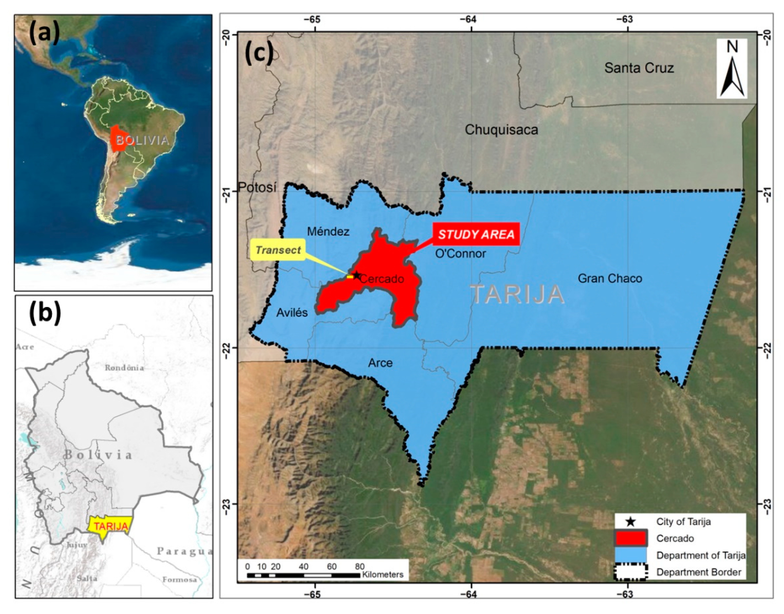
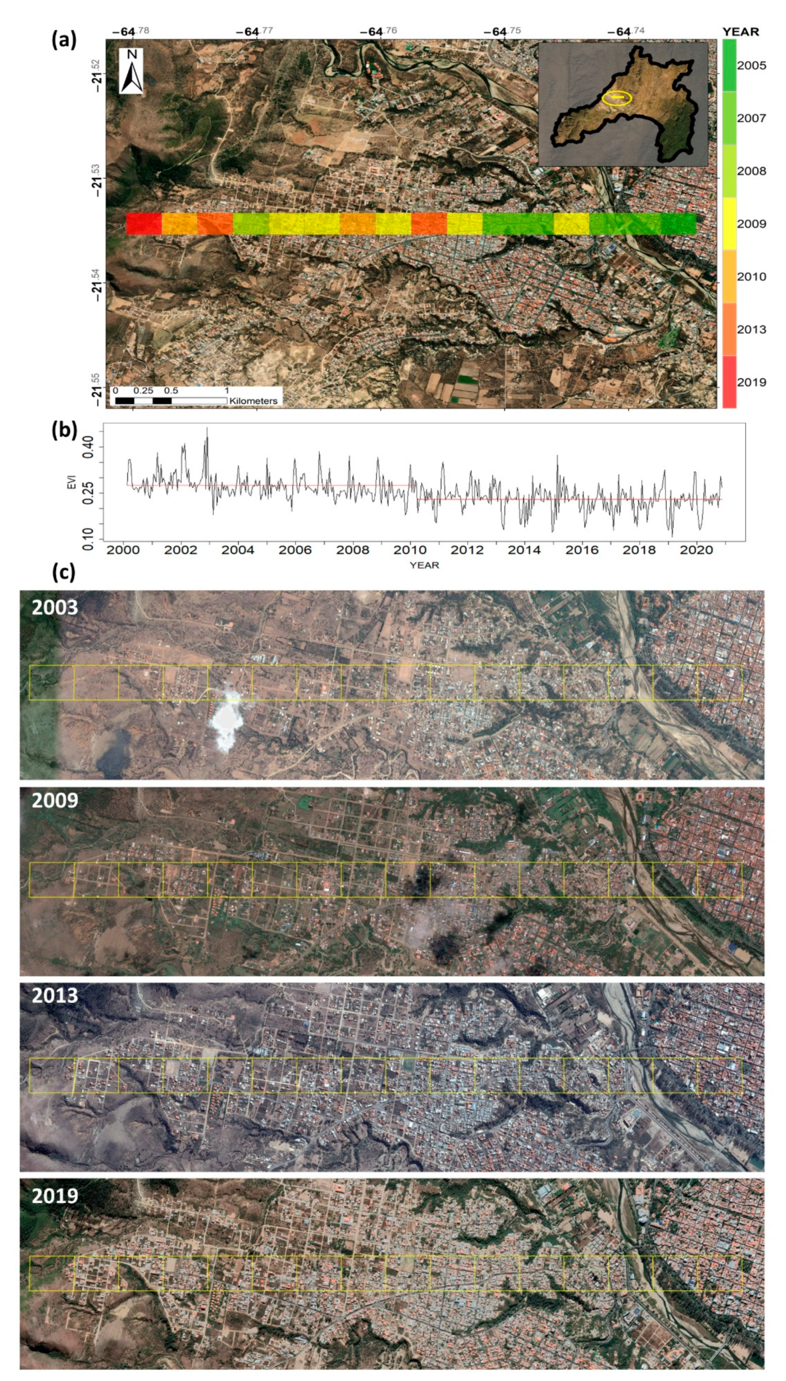
2.4. Example of Application: Analysis of Urban Growth Using EVI

The Cercado province (Figure 2) receives a continuous migratory flow from the Andean zone of Bolivia and other provinces of the department of Tarija [50], which causes land-use changes in the area. In 1950, the department of Tarija had a primarily rural population (76.4%), which according to the last census, was reduced to 35% [39]. The decrease of the rural population and increase of the urban population is due to several factors, including rural–urban migration and unequal conditions of governmental public investment and access to basic services [51].
Tarija (Figure 2c), located in the Cercado province, is the largest population center in southern Bolivia and a migratory destination. This study also used the downloaded data (EVI) to analyze the urban growth in Tarija during the last two decades. The EVI index has been previously used to relate urban population growth to the decrease in urban greenness [52] and to study vegetation patterns [53]. To study urban growth in Tarija, the MODIS program’s complete time series of EVI data was downloaded (18 February 2000 to 16 November 2020). This period included 478 images, gathered every 16 days and with a spatial resolution of 250 m.
A 5.12 km long transect was selected to study the city’s growth (see the yellow rectangle in Figure 2c). This transect was divided into 16 pixels starting at the city’s western limit and moving towards the city’s center (to the main square, Luis de Fuentes y Vargas). The data of each pixel was considered “trustful” if its values were between 0 and 1 [54]. The available gaps in the time series were filled using linear interpolation [55]. Seasonality was eliminated by using the decompose function of the stats library [13]. Finally, the EVI evolution was searched for breakpoints in each pixel using the changepoint package [56] and its function, cpt.meanvar, which detects changes in the mean and variance values of the data [57]. Within that function, the following selections were made: (i) AMOC (at most one changepoint) method for detecting a changepoint [58] and (ii) an asymptotic penalty with 95% confidence that this change has occurred (pen.value = 0.05).

3. Results

3.1. Download Times

Figure 3 shows the average download times measured for each package over 24 h of analysis. Overall, the average download time of an image for the study area was 121.55 s, ranging from 13.72 s to 650.72 s (Figure 3B). Packages ordered from the shortest to the longest are: 17.96 ± 3.71 s (AppEEARS), 35.90 ± 4.92 s (RGEE), 86.29 ± 9.36 s (MODIS package), 159.23 ± 59.01 s (RGISTools), 181.79 ± 131.06 s (MODIStsp), and 248.14 ± 16.26 s (MODISTools). As shown in Figure 3, download times vary over time, with the AppEEARS package being the most constant (±3.71 s) and the MODIStsp package the most variable (±131.06 s) (Figure 3A).
The Internet connection’s download speed (Figure 3C) was measured hourly over the course of 24 h. The download speed was faster at the beginning, followed by a sudden drop in speed between 8 and 12 a.m. and by a small increase and later a decrease in speed for the rest of the period.
Additionally, the post-processing times (rescaling and cropping) of the downloaded images were measured for each package. The measured times for each package and application were as follows: 0.79 s (AppEEARS), 0.80 s (RGEE), 0.86 s (MODIS package), 1.45 s (RGISTools), 0.83 s (MODIStsp), and 0.84 s (MODISTools).

3.2. Memory Used during Download

The memory used during each package’s 24 h varied from 579 MB to 886 MB (Figure 4). The AppEEARS application (597 MB) and the RGEE package (598 MB) were the most efficient packages due to the processing being done outside the user’s computer with R generating the queries. In the AppEEARS package, the connection was made using the AppEEARS application, while the RGEE package works in the Google cloud through GEE, minimizing the use of computer memory. On the other hand, the packages with the highest memory usage (MODIStsp, MODIS and RGISTools) require the download of an hdf image to generate the final product in tif format. The MODIStsp package required more memory (822 MB) to perform the data download process compared to the other packages.

3.3. Local Memory Occupied

The average local memory occupied by the final tif image of the study area was 9.44 MB, ranging between 0.10 MB to 55.40 MB. The local memory used to store the final product (tif image) for each tool was: 0.10 MB (AppEEARS application), 0.19 MB (RGEE), 0.19 MB (RGISTools), 0.30 MB (MODIStsp), 0.49 MB (MODISTools), and 55.40 MB (MODIS). Moreover, the average local memory occupied by the folder containing the image of the study area was 179.24 MB, ranging from 0.19 to 398 MB. The specific values for each tool are as follows: 0.19 MB (RGEE), 0.26 MB (AppEEARS), 0.98 MB (MODISTools), 310 MB (MODIStsp), 366 MB (MODIS), and 398 MB (RGISTools).

3.4. Downloaded File Characteristics

The standard file downloaded by the tools corresponds to an image in tif format (Figure 5). However, each tool uses different processes and formats to obtain the final output. For example, the AppEEARS application downloads a cropped tif image using the study area boundary utilizing WGS84 CRS and downloads raw EVI data (Figure 5a). In contrast, the MODIS package downloads raw EVI data (Figure 5b) and then crops it using the R post-processing tools. More specifically, it downloads an hdf image which is reprojected into a tif image of an extension equal to two full tiles using WGS84 CRS. The MODISTools package downloads a cropped tif image, according to a bounding box generated by distances starting from the centroid of the study area with WGS84 CRS, and the final data is rescaled EVI (Figure 5c). The MODIStsp package downloads an hdf image reprojected to a tif image and is cropped according to the bounding box of the study area, obtaining raw EVI data using WGS84 CRS (Figure 5d). Likewise, the RGEE package downloads a tif image that is cropped according to the bounding box of the study area using the WGS84 CRS, and the data is also in raw data EVI format (Figure 5e). Lastly, the RGISTools package downloads an hdf image which reprojects into a tif image and crops it according to the bounding box of the study area (Figure 5f). This package uses a sinusoidal CRS which needs to be reprojected to WGS84 during the post-processing process using the R tools.
Figure 6 summarizes the variables analyzed and the results obtained in the image download process using the different packages and application. Overall, it can be concluded that among the tools analyzed, the AppEEARS application and the RGEE package show the best performance in terms of the variables analyzed (download and post-processing times, memory usage during the download and of the final product, and the folder containing the file).

3.5. Example of Application: Analysis of Urban Growth Using EVI

The present study also explored the use of the previously downloaded EVI data and its applicability to detect urban growth in the main migratory location within the Cercado province, Tarija. Figure 7 shows the result of Tarija’s urban growth analysis using EVI, where the color of the rectangular transect in Figure 7A shows the years in which a breakpoint has been detected in the dynamics of the EVI index (Figure 7B). As depicted from the transect, the growth of Tarija expanded from east to west in the last decade, starting from the city center towards the suburbs. The breakpoints detected were also in agreement with satellite images; as an example, Figure 7C depicts the overlap of the grid and Google Earth Pro with four images for 2003, 2009, 2013, and 2019.

4. Discussion

4.1. Evaluation of R Tools

This study evaluated six tools (five R packages and one application) widely used to download MODIS images and compared their efficiency in downloading the same product. Each tool was analyzed by five metrics; The first two related to the download time and additional post-processing time, the third and fourth related to the memory used in the download and the local memory occupied by the data, and finally, the fifth related to the download format. In general terms, the applications that work in the cloud (AppEEARS and RGEE) showed more favorable results with respect to the rest of the tools, both in time and memory metrics, as well as in the delivery of the product in the final format. The AppEEARS application was designed to analyze information requests and optimize the transfer to the user [59]. Furthermore, in the case of multiple requests, the application automatically rotates its servers on demand to reduce requests times. Thus, as expected, this application showed the best efficiencies in our study. Alternatively, the MODIS package downloads information oriented to advanced GIS software and needs additional plug-ins to execute actions, such as reprojecting the whole image (tile) or cropping according to certain complex shapes [14]. This translates into less efficient time use and more memory space, similar to our findings. In addition, Tuck et al. [14] also highlighted that the data downloaded by MODISTools package was efficiently stored in the user’s computer memory for easy retrieval and manipulation. The MODIStsp package requires a longer download time and greater memory in the user’s computer for its execution and storage of data. This could be because this package allows the preprocessing and selection of specific layers and quality indicators extracted from the hdf images [18]. Our study has also corroborated the usefulness of the RGEE package since it accesses the GEE data catalog, services, and utilities through “the cloud” [17] and, thus, does not consume memory on the user’s computer [60]. Finally, as evidenced in this study, the RGISTools package—designed for downloading and processing information [16]—requires more information to be downloaded, which increases downloading time and the storage space needed for this data. As expected, the packages that require more post-processing steps (MODIStools and RGIStools) showed the longest execution times.
The methodology developed in this article has a high degree of automation using free software, such as R, which is widely used by the scientific community [14,18]. Moreover, the codes generated are simple and intuitive, ready to be available by users with basic programming skills (see Supplementary Material). As a complement, to process the information, it is necessary to work with common tools for managing vector layers and text files.
Further research could follow the same research line in the present study to evaluate other packages in R for downloading and processing higher resolution vegetation indices. For example, data generated by different sensors with a higher spatial resolution could be used to compare the influence of spatial and temporal resolution in the download and storage of large amounts of data. Moreover, libraries could be compared on the basis of how well they accommodate new technological advances, factoring in their use with equipment with greater processing capacity and the possibility of parallelizing processes.
The work highlighted the limited information available on the comparison of these tools. To our knowledge this is the first work that evaluates the available tools in R for downloading MODIS products, which will allow the end user to make a more informed decision when choosing the downloading tool that best suits their requirements and research needs.

4.2. Example of Application: Analysis of Urban Growth Using EVI

The use of the breaking point method in the 20 years of available MODIS data has allowed us to identify the existence of a strong link between land-use change and population growth, in agreement with previous studies [61,62]. In our study, the growth of Tarija and its urban area was easily identifiable using EVI. This demonstrated that urbanized areas strongly influence vegetation cover in the area [53], in most cases reducing vegetation cover in the area [63]. The EVI index is widely used to study the effects of urban development on the vegetation of the area. For instance, Zhou et al. [64] concluded that the EVI index decreases significantly with the increasing intensity of urban growth in cities in China. Other research reports that the EVI index is used to analyze the greenness influenced by land cover changes, which occur in areas with high rates of change [65].In addition, nighttime light satellite imagery might be merged with other data to map and improve urban percentage estimates of cities [66] and investigate how rapid urbanization transforms areas with vegetation cover into impervious surfaces which contributes to the reduction of vegetation cover and the increase of land surface temperature generating urban heat islands [63].
The EVI index effectively confirms Tarija’s urban changes and demonstrates the rapid growth of its urban area towards the west from 2005 to 2019. In recent years, the rapid population growth has posed issues for cities in developing countries, which are not prepared to meet the demand generated by their population growth [52]. Therefore, this type of study is of great help for decision making to guide the growth of the city in a sustainable way to meet the demand of the population. It is worthy to note that the incorporation of other indices, such as nighttime light satellite imagery and the normalized difference built-up index, NDBI [67,68], could improve the results of mapping urban built-up areas.

5. Conclusions

The objective of the present study was to evaluate the available tools for downloading MODIS data. Five packages available in R (MODIS, MODISTools, RGEE, MODIStsp, RGISTools) and an application (AppEEARS) were evaluated. These tools allow the user to work with large amounts of data efficiently and locally, reducing dependence on external services. This work presents a unique contribution to the scientific community for data downloading because, for the first time, the available and most used libraries for MODIS data downloading were evaluated in a comparative way and under the same parameters. Therefore, this study serves as a basis for choosing the tool that best suits the user’s needs.
Overall, the RGEE package and the AppEEARS application showed the highest efficiencies of all the tools evaluated. Related to computer memory usage, the most efficient tools were those that work directly in the “cloud” and those that work with text queries (RGEE and AppEEARS, respectively). On the other hand, lower efficiencies were found with the other tools that required downloading different files beforehand (hdf). The folders generated by these tools contain all the necessary files that enable the tools to deliver the final product (tif image). The tools showing the best efficiency only had the final tif image (RGEE), together with complementary text files (AppEEARS). On the other hand, lower efficiencies were found in tools that store the hdf and the tif images. The size of the downloaded image plays an important role when analyzing large amounts of data and storing them locally, showing that the least efficient packages were those that the final product (tif image) corresponds to full tiles. It would be interesting that each package presents a small technical description within its reference manual with standard performance metrics for comparison by users.
Having these tools to automate the download of MODIS products has great potential. As an example of an application, in this work, we used EVI data for urban growth monitoring in Tarija, Bolivia with satisfactory results. The use of the EVI index in areas with vegetation is a suitable index for the estimation of urban growth. However, its efficiency could be improved by including other sources of remote information, such as nighttime light satellite imagery.

Supplementary Materials

The following are available online at https://www.mdpi.com/article/10.3390/rs14143404/s1, Supplementary A: Modis_Library.R, Supplementary B: Modistools_library.R, Supplementary C: APPEEARS_app.R., Supplementary D: rgee_library.R, Supplementary E: MODIStsp_library.R, and Supplementary F: rgistools_library.R.

Author Contributions

Conceptualization, M.J.C.-T., M.M.-S., M.G.-A. and M.A.C.-B.; methodology, M.J.C.-T., M.M.-S., M.G.-A. and M.A.C.-B.; software, M.J.C.-T., E.L. and M.A.C.-B.; formal analysis, M.J.C.-T., E.L. and M.A.C.-B.; data curation, M.J.C.-T.; writing—original draft preparation, M.J.C.-T. and E.L.; writing—review and editing, M.M.-S., M.G.-A. and M.A.C.-B.; visualization, M.J.C.-T., E.L. and M.A.C.-B.; supervision, M.J.C.-T. and M.A.C.-B. All authors have read and agreed to the published version of the manuscript.

Funding

The APC was funded by the THERRAE research group, by Public University of Navarre.

Conflicts of Interest

The authors declare no conflict of interest.

References

  1. Donaldson, D.; Storeygard, A. The View from Above: Applications of Satellite Data in Economics. J. Econ. Perspect. 2016, 30, 171–198. [Google Scholar] [CrossRef] [Green Version]
  2. Huang, C.; Chen, Y.; Zhang, S.; Wu, J. Detecting, Extracting, and Monitoring Surface Water From Space Using Optical Sensors: A Review. Rev. Geophys. 2018, 56, 333–360. [Google Scholar] [CrossRef]
  3. Leone, A.P.; Wright, G.G.; Corves, C. The Application of Satellite Remote Sensing for Soil Studies in Upland Areas of Southern Italy. Int. J. Remote Sens. 1995, 16, 1087–1105. [Google Scholar] [CrossRef]
  4. Zhang, N.; Wang, M.; Wang, N. Precision Agriculture—A Worldwide Overview. Comput. Electron. Agric. 2002, 36, 113–132. [Google Scholar] [CrossRef]
  5. Lu, D. The Potential and Challenge of Remote Sensing-Based Biomass Estimation. Int. J. Remote Sens. 2006, 27, 1297–1328. [Google Scholar] [CrossRef]
  6. Wardlow, B.D.; Egbert, S.L. Large-Area Crop Mapping Using Time-Series MODIS 250 m NDVI Data: An Assessment for the U.S. Central Great Plains. Remote Sens. Environ. 2008, 112, 1096–1116. [Google Scholar] [CrossRef]
  7. Wardlow, B.D.; Egbert, S.L.; Kastens, J.H. Analysis of Time-Series MODIS 250 m Vegetation Index Data for Crop Classification in the U.S. Central Great Plains. Remote Sens. Environ. 2007, 108, 290–310. [Google Scholar] [CrossRef] [Green Version]
  8. Sakamoto, T.; Yokozawa, M.; Toritani, H.; Shibayama, M.; Ishitsuka, N.; Ohno, H. A Crop Phenology Detection Method Using Time-Series MODIS Data. Remote Sens. Environ. 2005, 96, 366–374. [Google Scholar] [CrossRef]
  9. Sun, W.; Song, X.; Mu, X.; Gao, P.; Wang, F.; Zhao, G. Spatiotemporal Vegetation Cover Variations Associated with Climate Change and Ecological Restoration in the Loess Plateau. Agric. For. Meteorol. 2015, 209, 87–99. [Google Scholar] [CrossRef]
  10. Churkina, G.; Schimel, D.; Braswell, B.; Xiao, X. Spatial Analysis of Growing Season Length Control over Net Ecosystem Exchange. Glob. Chang. 2005, 11, 1777–1787. [Google Scholar] [CrossRef]
  11. Huete, A.; Didan, K.; Miura, T.; Rodriguez, E.P.; Gao, X.; Ferreira, L.G. Overview of the Radiometric and Biophysical Performance of the MODIS Vegetation Indices. Remote Sens. Environ. 2002, 83, 195–213. [Google Scholar] [CrossRef]
  12. Son, N.T.; Chen, C.F.; Chen, C.R.; Minh, V.Q.; Trung, N.H. A Comparative Analysis of Multitemporal MODIS EVI and NDVI Data for Large-Scale Rice Yield Estimation. Agric. For. Meteorol. 2014, 197, 52–64. [Google Scholar] [CrossRef]
  13. R Core Team. R: A Language and Environment for Statistical Computing; R Found for Statistical Computing: Vienna, Austria, 2020. [Google Scholar]
  14. Tuck, S.L.; Phillips, H.R.P.; Hintzen, R.E.; Scharlemann, J.P.W.; Purvis, A.; Hudson, L.N. MODISTools-Downloading and Processing MODIS Remotely Sensed Data in R. Ecol. Evol. 2014, 4, 4658–4668. [Google Scholar] [CrossRef] [PubMed] [Green Version]
  15. Mattiuzzi, M.; Detsch, F. Acquisition and Processing of MODIS Products. R Package Version 1.2.3. Available online: https://github.com/MatMatt/MODIS (accessed on 14 June 2022).
  16. Pérez-Goya, U.; Montesino -SanMartin, M.; Militino, A.F.; Ugarte, M.D. RGISTools: Handling Multiplatform Satellite Images. 2020. Available online: https://github.com/spatialstatisticsupna/RGISTools#RGISTools (accessed on 14 June 2022).
  17. Aybar, C.; Wu, Q.; Bautista, L.; Yali, R.; Barja, A. Rgee: An R Package for Interacting with Google Earth Engine. Available online: https://github.com/r-spatial/rgee (accessed on 15 August 2020).
  18. Busetto, L.; Ranghetti, L. MODIStsp: An R Package for Automatic Preprocessing of MODIS Land Products Time Series. Comput. Geosci. 2016, 97, 40–48. [Google Scholar] [CrossRef] [Green Version]
  19. AppEEARS Team Application for Extracting and Exploring Analysis Ready Samples (AppEEARS). Available online: https://lpdaac.usgs.gov/tools/appeears/ (accessed on 9 January 2021).
  20. Militino, A.F.; Montesino-SanMartin, M.; Pérez-Goya, U.; Ugarte, M.D. Using RGISTools to Estimate Water Levels in Reservoirs and Lakes. Remote Sens. 2020, 12, 1–1934. [Google Scholar] [CrossRef]
  21. Vuolo, F.; Mattiuzzi, M.; Klisch, A.; Atzberger, C. Data Service Platform for MODIS Vegetation Indices Time Series Processing at BOKU Vienna: Current Status and Future Perspectives. In Proceedings of the Earth Resources and Environmental Remote Sensing/GIS Applications III; Habib, S., Messinger, D., Maltese, A., Michel, U., Civco, D.L., Ehlers, M., Schulz, K., Nikolakopoulos, K.G., Eds.; SPIE: Edinburgh, UK, 2012; Volume 8538, pp. 83–92. [Google Scholar]
  22. Heck, E.; de Beurs, K.M.; Owsley, B.C.; Henebry, G.M. Evaluation of the MODIS Collections 5 and 6 for Change Analysis of Vegetation and Land Surface Temperature Dynamics in North and South America. ISPRS J. Photogramm. Remote Sens. 2019, 156, 121–134. [Google Scholar] [CrossRef]
  23. Justice, C.O.; Townshend, J.R.G.; Vermote, E.F.; Masuoka, E.; Wolfe, R.E.; Saleous, N.; Roy, D.P.; Morisette, J.T. An Overview of MODIS Land Data Processing and Product Status. Remote Sens. Environ. 2002, 83, 3–15. [Google Scholar] [CrossRef]
  24. Savtchenko, A.; Ouzounov, D.; Ahmad, S.; Acker, J.; Leptoukh, G.; Koziana, J.; Nickless, D. Terra and Aqua MODIS Products Available from NASA GES DAAC. Adv. Sp. Res. 2004, 34, 710–714. [Google Scholar] [CrossRef]
  25. NASA. MODIS Web. Available online: https://modis.gsfc.nasa.gov/ (accessed on 14 January 2021).
  26. Gao, X.; Huete, A.R.; Ni, W.; Miura, T. Optical-Biophysical Relationships of Vegetation Spectra without Background Contamination. Remote Sens. Environ. 2000, 74, 609–620. [Google Scholar] [CrossRef]
  27. Anaya, J.A.; Chuvieco, E.; Palacios-Orueta, A. Aboveground Biomass Assessment in Colombia: A Remote Sensing Approach. For. Ecol. Manag. 2009, 257, 1237–1246. [Google Scholar] [CrossRef]
  28. Jiang, Z.; Huete, A.R.; Didan, K.; Miura, T. Development of a Two-Band Enhanced Vegetation Index without a Blue Band. Remote Sens. Environ. 2008, 112, 3833–3845. [Google Scholar] [CrossRef]
  29. Zhang, X.; Friedl, M.A.; Schaaf, C.B.; Strahler, A.H.; Hodges, J.C.F.; Gao, F.; Reed, B.C.; Huete, A. Monitoring Vegetation Phenology Using MODIS. Remote Sens. Environ. 2003, 84, 471–475. [Google Scholar] [CrossRef]
  30. RStudio Team. RStudio: Integrated Development Environment for R 2020; RStudio: Boston, MA, USA, 2020. [Google Scholar]
  31. Hijmans, R.J. Raster: Geographic Data Analysis and Modeling, R Packag version 3.3-13; 2020. Available online: http://cran.r-project.org/package=raster (accessed on 14 June 2022).
  32. The Comprehensive R Archive Network (CRAN). Available online: https://cran.r-project.org/ (accessed on 14 June 2022).
  33. GitHub. Available online: https://github.com/ (accessed on 14 June 2022).
  34. DAAC LP. Land Processes Distributed Active Archive Center (LP DAAC). Available online: https://lpdaac.usgs.gov/ (accessed on 14 June 2022).
  35. Hufkens, K. MODISTools: Interface to the “MODIS Land Products Subsets” Web Services. R Package version 1.1.1. Available online: https://CRAN.R-project.org/package=MODISTools (accessed on 14 June 2022).
  36. NASA. Web Service: MODIS/VIIRS Land Products. Available online: https://modis.ornl.gov/data/modis_webservice.html (accessed on 14 June 2022).
  37. NASA. NASA Web Server. Available online: https://earthdata.nasa.gov/ (accessed on 14 June 2022).
  38. Preston, D.; Macklin, M.; Warburton, J. Fewer People, Less Erosion: The Twentieth Century in Southern Bolivia. Geogr. J. 1997, 163, 198–205. [Google Scholar] [CrossRef]
  39. Instituto Nacional de Estadística–INE Censo de Población y Vivienda. 2012. Available online: https://www.ine.gob.bo/ (accessed on 14 January 2022).
  40. GeoBolivia-Infraestructura de Datos Espaciales Del Estado Plurinacional de Bolivia, GeoBolivia Web Server. Available online: http://geo.gob.bo/portal/ (accessed on 14 June 2022).
  41. Baccarelli, E.; Biagi, M.; Cordeschi, N.; Pelizzoni, C. Minimization of Download Times for Large Files over Wireless Channels. IEEE Trans. Mob. Comput. 2007, 6, 1105–1115. [Google Scholar] [CrossRef]
  42. Joshi, G.; Liu, Y.; Soljanin, E. Coding for Fast Content Download. In Proceedings of the 2012 50th Annual Allerton Conference on Communication, Control, and Computing (Allerton 2012), Monticello, IL, USA, 1–5 October 2012; pp. 326–333. [Google Scholar] [CrossRef] [Green Version]
  43. Hester, J. Bench: High Precision Timing of R Expressions. R Package. Version 1.1.1. Available online: https://CRAN.R-project.org/package=bench (accessed on 14 June 2022).
  44. Panda, P.R.; Dutt, N.D.; Nicolau, A. Local Memory Exploration and Optimization in Embedded Systems. IEEE Trans. Comput. Des. Integr. Circuits Syst. 1999, 18, 3–13. [Google Scholar] [CrossRef]
  45. Fang, J.; Sips, H.; Jääskeläinen, P.; Varbanescu, A.L. Grover: Looking for Performance Improvement by Disabling Local Memory Usage in OpenCL Kernels. In Proceedings of the 2014 43nd International Conference on Parallel Processing (ICPP), Minneapolis, MN, USA, 8–10 November 2014; pp. 162–171. [Google Scholar] [CrossRef]
  46. Cruces, N.; Seco, D.; Guitérrez, G. A Compact Representation of Raster Time Series. In Proceedings of the 2019 Data Compression Conference (DCC), Snowbird, UT, USA, 26–29 March 2019; pp. 103–111. [Google Scholar]
  47. Wu, P.; Fang, Y.; Chen, B.; Zhao, Y.; Yan, M. The Raster Data Management in a Spatial Data Grid. In Proceedings of the 2009 5th International Conference on Wireless Communications, Networking and Mobile Computing, Beijing, China, 24–26 September 2009; pp. 1–4. [Google Scholar]
  48. Rudis, B.; Mecum, B.; Mooney, G. Speedtest. Available online: https://github.com/hrbrmstr/speedtest (accessed on 14 June 2022).
  49. Jain, A.; Nandakumar, K.; Ross, A. Score Normalization in Multimodal Biometric Systems. Pattern Recognit. 2005, 38, 2270–2285. [Google Scholar] [CrossRef]
  50. Lea Plaza, S. Tarija En Los Imaginarios Urbanos. Temas Soc. 2003, 24, 152–170. [Google Scholar]
  51. Lizárraga Aranibar, P. Vacaflores Rivero, C. Cambio y Poder En Tarija: La Emergencia de La Lucha Campesina; Plural Editores: La Paz, Bolivia, 2007; ISBN 9789995411121. [Google Scholar]
  52. Sun, L.; Chen, J.; Li, Q.; Huang, D. Dramatic Uneven Urbanization of Large Cities throughout the World in Recent Decades. Nat. Commun. 2020, 11, 1–9. [Google Scholar] [CrossRef]
  53. Jenerette, G.D.; Miller, G.; Buyantuev, A.; Pataki, D.E.; Gillespie, T.W.; Pincetl, S. Urban Vegetation and Income Segregation in Drylands: A Synthesis of Seven Metropolitan Regions in the Southwestern United States. Environ. Res. Lett. 2013, 8, 21–27. [Google Scholar] [CrossRef] [Green Version]
  54. Didan, K.; Munoz, A.B.; Solano, R.; Huete, A. MODIS Vegetation Index User ’s Guide (Collection 6); University of Arizona: Tuscon, AZ, USA, 2015; Volume 31. [Google Scholar]
  55. Gnauck, A. Interpolation and Approximation of Water Quality Time Series and Process Identification. Anal. Bioanal. Chem. 2004, 380, 484–492. [Google Scholar] [CrossRef]
  56. Killick, R.; Haynes, K.; Eckley, I. Changepoint: An R Package for Changepoint Analysis. R Package Version 2.2.2. Available online: https://CRAN.R-project.org/package=changepoint (accessed on 14 June 2022).
  57. Militino, A.F.; Ugarte, M.D.; Pérez-Goya, U. Detecting Change-Points in the Time Series of Surfaces Occupied by Pre-Defined NDVI Categories in Continental Spain from 1981 to 2015. Stud. Syst. Decis. Control 2018, 142, 295–307. [Google Scholar] [CrossRef]
  58. Van den Burg, G.J.J.; Williams, C.K.I. An Evaluation of Change Point Detection Algorithms. arXiv 2020, arXiv:2003.06222. [Google Scholar]
  59. Davis, B.N.; Werpy, J.; Friesz, A.; Impecoven, K.; Quenzer, R.L.; Maiersperger, T.; Meyer, D.J. Interactive Access to LP DAAC Satellite Data Archives Through a Combination of Open-Source and Custom Middleware Web Services. IEEE Geosci. Remote Sens. Mag. 2015, 3, 8–20. [Google Scholar] [CrossRef]
  60. Gorelick, N.; Hancher, M.; Dixon, M.; Ilyushchenko, S.; Thau, D.; Moore, R. Google Earth Engine: Planetary-Scale Geospatial Analysis for Everyone. Remote Sens. Environ. 2017, 202, 18–27. [Google Scholar] [CrossRef]
  61. Hereher, M.E. Effect of Land Use/Cover Change on Land Surface Temperatures-The Nile Delta, Egypt. J. African Earth Sci. 2017, 126, 75–83. [Google Scholar] [CrossRef]
  62. Wan, H.; Shao, Y.; Campbell, J.B.; Deng, X. Mapping Annual Urban Change Using Time Series Landsat and NLCD. Photogramm. Eng. Remote Sens. 2019, 85, 715–724. [Google Scholar] [CrossRef]
  63. Yao, R.; Wang, L.; Gui, X.; Zheng, Y.; Zhang, H.; Huang, X. Urbanization Effects on Vegetation and Surface Urban Heat Islands in China’s Yangtze River Basin. Remote Sens. 2017, 9, 540. [Google Scholar] [CrossRef] [Green Version]
  64. Zhou, D.; Zhao, S.; Liu, S.; Zhang, L. Spatiotemporal Trends of Terrestrial Vegetation Activity along the Urban Development Intensity Gradient in China ’ s 32 Major Cities. Sci. Total Environ. 2014, 488, 136–145. [Google Scholar] [CrossRef]
  65. Zhu, Z.; Fu, Y.; Woodcock, C.E.; Olofsson, P.; Vogelmann, J.E.; Holden, C.; Wang, M.; Dai, S.; Yu, Y. Including Land Cover Change in Analysis of Greenness Trends Using All Available Landsat 5, 7, and 8 Images: A Case Study from Guangzhou, China (2000–2014). Remote Sens. Environ. 2016, 185, 243–257. [Google Scholar] [CrossRef] [Green Version]
  66. Huang, X.; Schneider, A.; Friedl, M.A. Mapping Sub-Pixel Urban Expansion in China Using MODIS and DMSP/OLS Nighttime Lights. Remote Sens. Environ. 2016, 175, 92–108. [Google Scholar] [CrossRef]
  67. Zha, Y.; Gao, J.; Ni, S. Use of Normalized Difference Built-up Index in Automatically Mapping Urban Areas from TM Imagery. Int. J. Remote Sens. 2003, 24, 583–594. [Google Scholar] [CrossRef]
  68. He, C.; Shi, P.; Xie, D.; Zhao, Y. Improving the Normalized Difference Built-up Index to Map Urban Built-up Areas Using a Semiautomatic Segmentation Approach. Remote Sens. Lett. 2010, 1, 213–221. [Google Scholar] [CrossRef] [Green Version]
Figure 1. The flowchart is divided into three sections, packages, processing, and output colored in grey. Section 1 (packages) includes the MODIS data download packages available in R. Part 2 (processing) illustrates each package’s process for data download and its functions. Finally, part 3 (output) presents the output file type (tif) generated by each package for display.
Remotesensing 14 03404 g001
Figure 2. Location of Bolivia in South America and the department of Tarija within Bolivia (a,b, respectively). (c) In red, the location of the study area (Cercado province) within Tarija.
Remotesensing 14 03404 g002
Figure 3. Download times with the Sys.Time package. (a) Aggregated data at the packet level. (b) Time evolution over 24 h (GMT + 1) (c) Time evolution of Internet speed over 24 h.
Remotesensing 14 03404 g003
Figure 4. Memory used by each package during the 24-hour download period, obtained by the bench_process_memory function of the Bench package.
Remotesensing 14 03404 g004
Figure 5. Downloaded EVI images for 3 December 2015 using the evaluated packages and application with a WGS84 reference coordinate system, including the contour of the study area. (a) AppEEARS, (b) MODIS, (d) MODIStsp, and (e) RGEE show raw EVI data without applying the scale factor. (c) MODISTools shows EVI data after applying the scale factor and (f) RGISTools with raw EVI data without using the scale factor (post-processed image from sinusoidal coordinate system to WGS84).
Remotesensing 14 03404 g005
Figure 6. Summary and classification of results obtained for each analysis performed by the evaluated tool. The analyzed characteristics have been standardized and classified with 1 being the maximum (best) and 0 the minimum (worse).
Remotesensing 14 03404 g006
Figure 7. (a) Transect corresponding to the city of Tarija, including the years in which an abrupt change in the mean and variance of the EVI data is detected. (b) Time series of a pixel that presents its breakpoint in 2010 and (c) Google Earth Pro archive images showing the real temporal evolution of the transect.
Remotesensing 14 03404 g007
Table 1. File format and characteristics of the application and packages evaluated.
Package/ApplicationFormatCRS 1Downloaded FilesImage Boundary
AppEEARStifWGS84EVI + qualityCropped image, according to the contour of the study area.
MODIShdf y tifWGS84EVIComplete scenes (tiles)
MODISToolstifWGS84EVICropped image, according to a bounding box generated from distances, starting from the centroid of the study area.
MODIStsphdf y tifWGS84EVICropped image, according to the contour of the study area.
RGEEtifWGS84EVICropped image, according to the contour of the study area.
RGISToolshdf y tifSinusoidalEVICropped image, according to the contour of the study area.
1 CRS: coordinate reference system.
Publisher’s Note: MDPI stays neutral with regard to jurisdictional claims in published maps and institutional affiliations.

