
High-Precision Population Spatialization in Metropolises Based on Ensemble Learning: A Case Study of Beijing, China

 ,
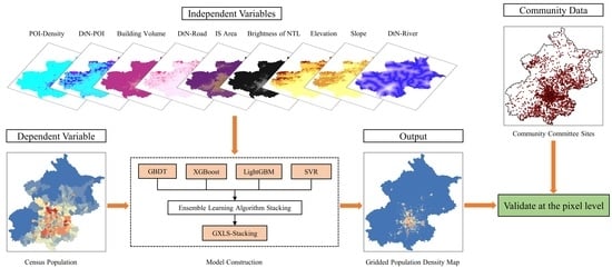
, Abstract
Share and Cite
Bao, W.; Gong, A.; Zhao, Y.; Chen, S.; Ba, W.; He, Y. High-Precision Population Spatialization in Metropolises Based on Ensemble Learning: A Case Study of Beijing, China. Remote Sens. 2022, 14, 3654. https://doi.org/10.3390/rs14153654
Bao W, Gong A, Zhao Y, Chen S, Ba W, He Y. High-Precision Population Spatialization in Metropolises Based on Ensemble Learning: A Case Study of Beijing, China. Remote Sensing. 2022; 14(15):3654. https://doi.org/10.3390/rs14153654
Chicago/Turabian StyleBao, Wenxuan, Adu Gong, Yiran Zhao, Shuaiqiang Chen, Wanru Ba, and Yuan He. 2022. "High-Precision Population Spatialization in Metropolises Based on Ensemble Learning: A Case Study of Beijing, China" Remote Sensing 14, no. 15: 3654. https://doi.org/10.3390/rs14153654
APA StyleBao, W., Gong, A., Zhao, Y., Chen, S., Ba, W., & He, Y. (2022). High-Precision Population Spatialization in Metropolises Based on Ensemble Learning: A Case Study of Beijing, China. Remote Sensing, 14(15), 3654. https://doi.org/10.3390/rs14153654