Satellite Imagery-Based Identification of High-Risk Areas of Schistosome Intermediate Snail Hosts Spread after Flood
Abstract
:1. Introduction
2. Materials and Methods
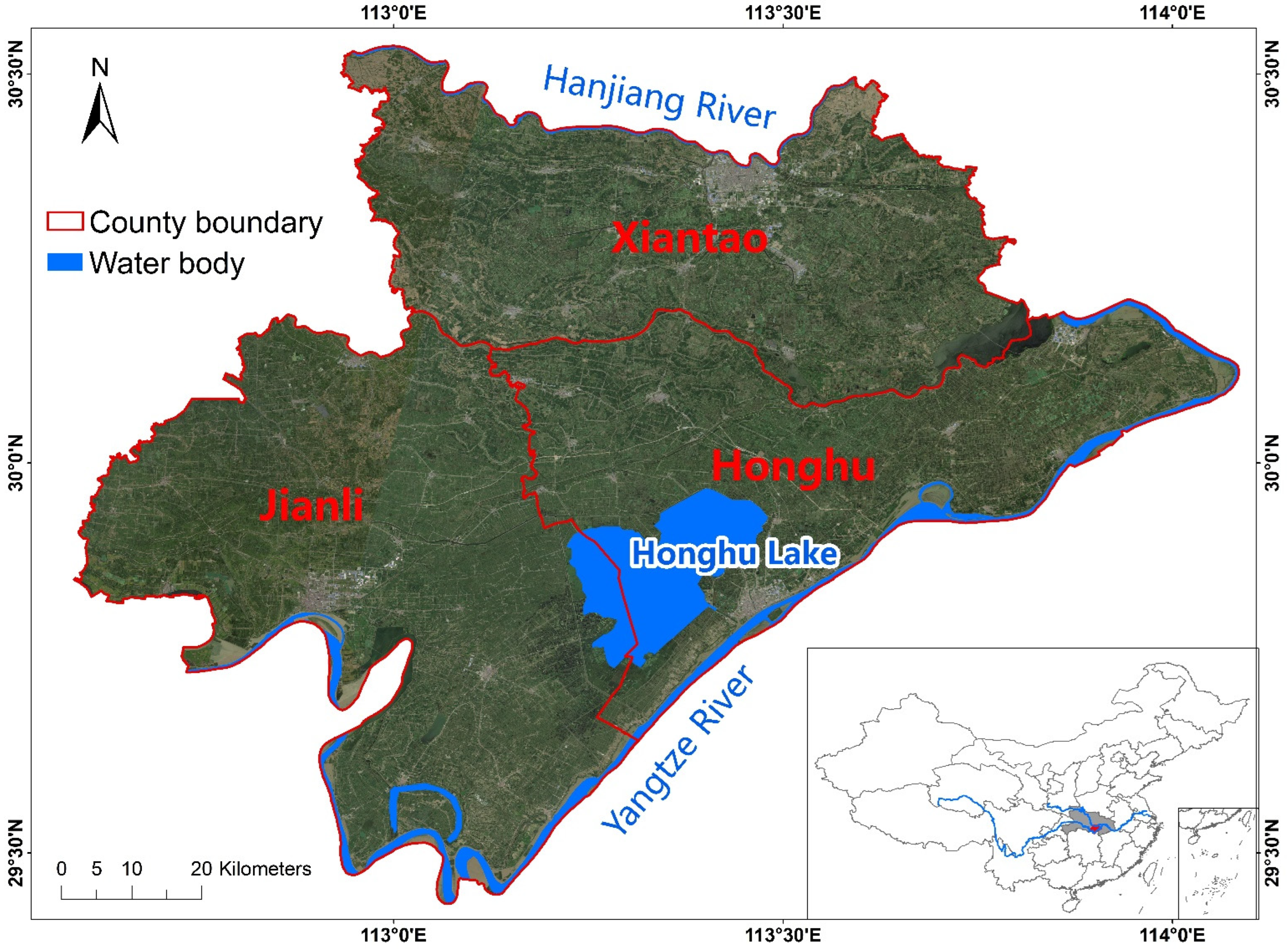
2.1. Study Area
2.2. Snail Distribution Dataset through Snail Field Surveys
2.3. Remote Sensing Datasets
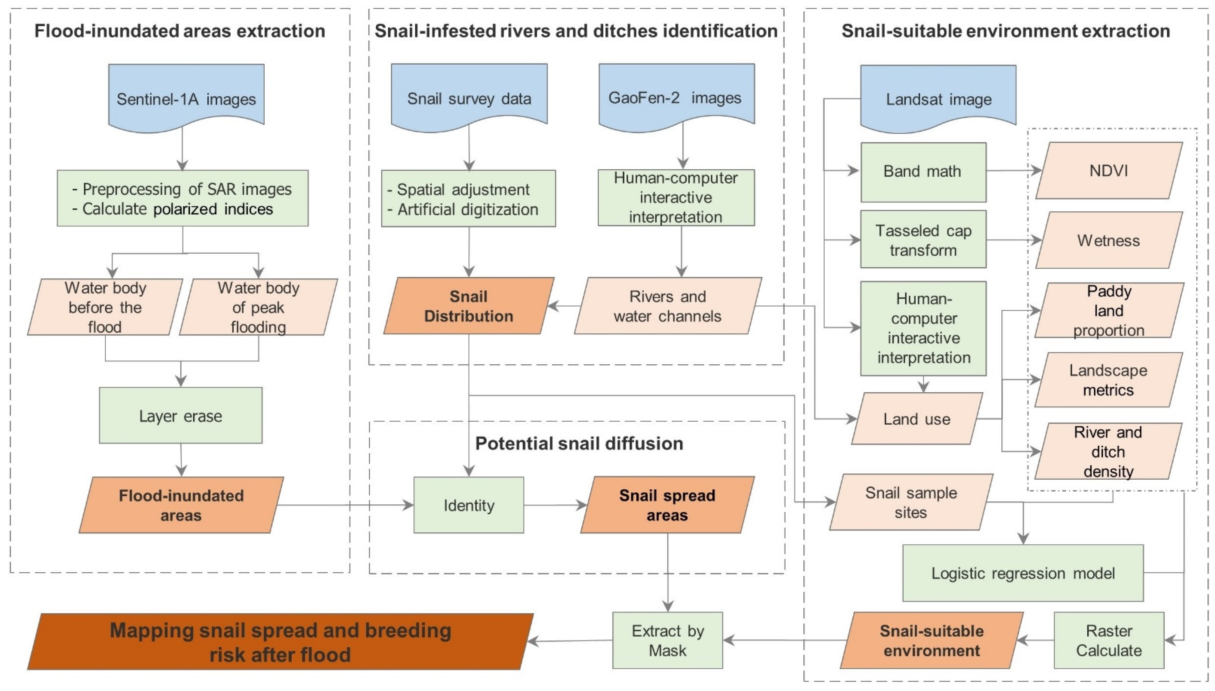
2.4. Methods
2.4.1. Mapping Flood-Inundated Areas Using Sentinel-1 SAR Imagery
2.4.2. Mapping Snail Spread Areas Based on Inundation Map and Snail-Infested Rivers and Channels
2.4.3. Mapping Breeding Risk in the Snail Spread Areas Based on Multiple Variances and Univariate Logistic Regression
3. Results
3.1. The Flood-Inundated Area Map
3.2. Snail Spread Area Map
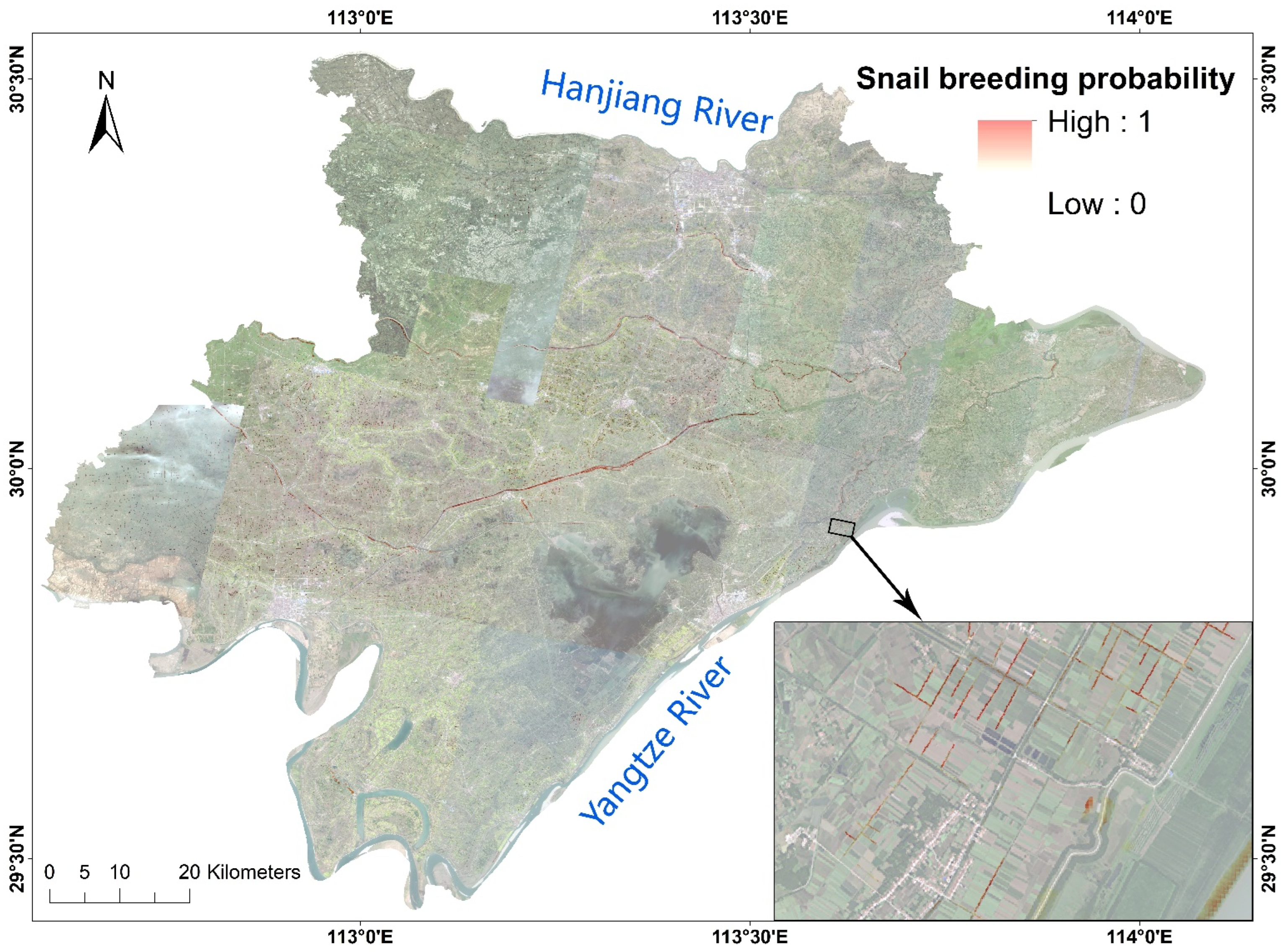
3.3. Snail Breeding Risk Probability Estimation Result
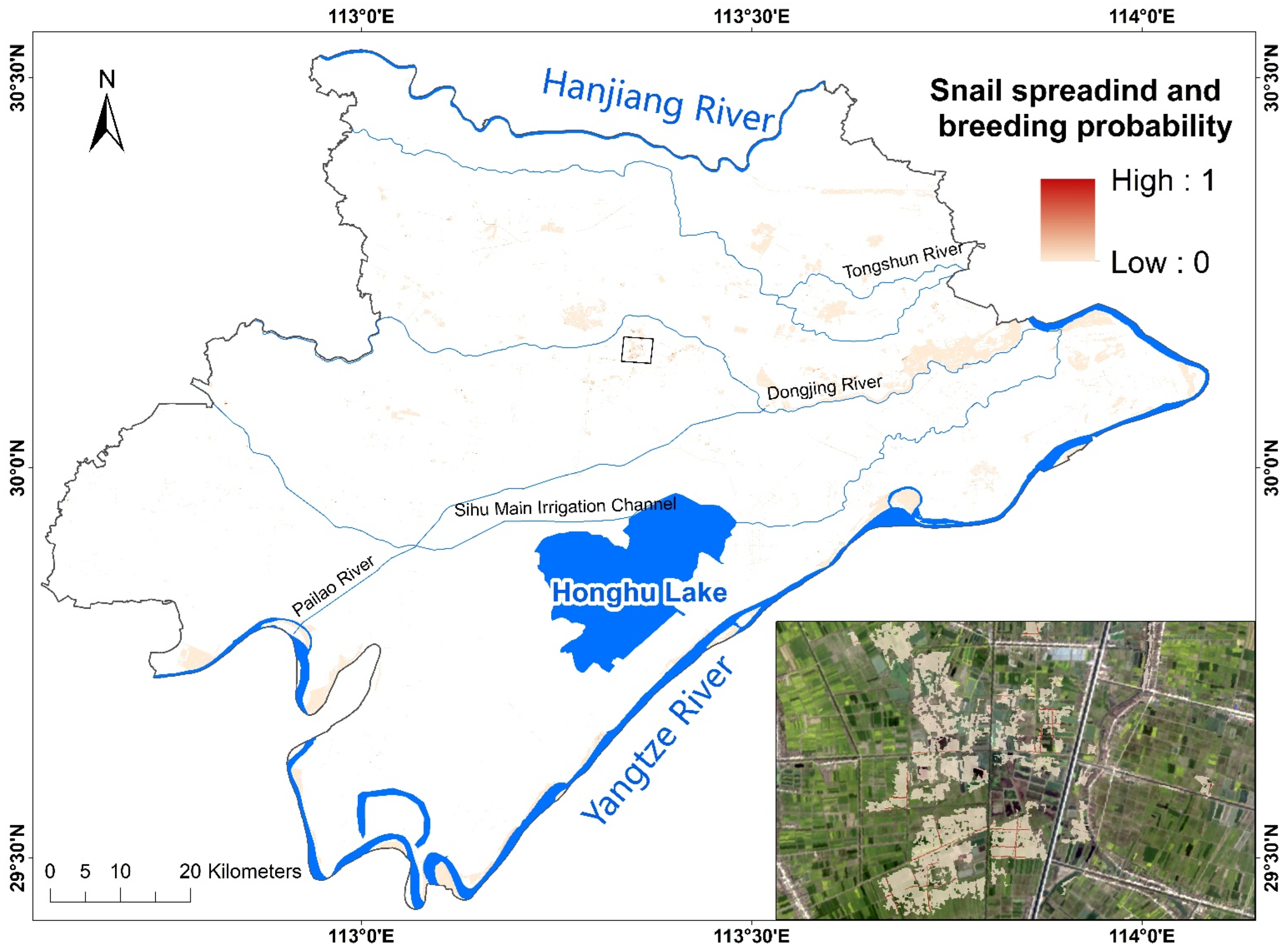
3.4. Final Potential Snail Spreading and Breeding Risk Map
4. Discussion
5. Conclusions
Author Contributions
Funding
Data Availability Statement
Acknowledgments
Conflicts of Interest
References
- Soriano, J.B.; Banoub, J.A.M.; Kanchan, T.; Yasin, Y.J. Gbd 2017 dalys and hale collaborators. Global, regional, and national disability-adjusted life-years (dalys) for 359 diseases and injuries and healthy life expectancy (hale) for 195 countries and territories, 1990–2017: A systematic analysis for the global burden of disease study (vol 392, pg 1859, 2018). Lancet 2019, 393, E44. [Google Scholar]
- McManus, D.P.; Dunne, D.W.; Sacko, M.; Utzinger, J.; Vennervald, B.J.; Zhou, X.N. Schistosomiasis. Nat. Rev. Dis. Primers 2018, 4, 13. [Google Scholar] [CrossRef] [PubMed]
- Lo, N.C.; Gurarie, D.; Yoon, N.; Coulibaly, J.T.; Bendavid, E.; Andrews, J.R.; King, C.H. Impact and cost-effectiveness of snail control to achieve disease control targets for schistosomiasis. Proc. Natl. Acad. Sci. USA 2018, 115, E584–E591. [Google Scholar] [CrossRef] [PubMed] [Green Version]
- Sokolow, S.H.; Wood, C.L.; Jones, I.J.; Swartz, S.J.; Lopez, M.; Hsieh, M.H.; Lafferty, K.D.; Kuris, A.M.; Rickards, C.; De Leo, G.A. Global assessment of schistosomiasis control over the past century shows targeting the snail intermediate host works best. PLoS Negl. Trop. Dis. 2016, 10, e0004794. [Google Scholar] [CrossRef]
- WHO. Field Use of Molluscicides in Schistosomiasis Control Programmes: An Operational Manual for Programme Managers; World Health Organization: Geneva, Switzerland, 2017.
- Habib, M.R.; Lv, S.; Rollinson, D.; Zhou, X.N. Invasion and dispersal of biomphalaria species: Increased vigilance needed to prevent the introduction and spread of schistosomiasis. Front. Med. 2021, 8, 614797. [Google Scholar] [CrossRef] [PubMed]
- Lv, S.; Lv, C.; Li, Y.L.; Xu, J.; Hong, Q.B.; Zhou, J.; Zhang, J.F.; Wen, L.Y.; Zhang, S.Q.; Lin, D.D.; et al. Expert consensus on the strategy and measures to interrupt the transmission of schistosomiasis in China. Chin. J. Schisto. Control 2021, 33, 10–14. [Google Scholar]
- Dai, S.M.; Edwards, J.; Guan, Z.; Lv, S.; Li, S.Z.; Zhang, L.J.; Feng, J.; Feng, N.; Zhou, X.N.; Xu, J. Change patterns of oncomelanid snail burden in areas within the yangtze river drainage after the three gorges dam operated. Infect. Dis. Poverty 2019, 8, 48. [Google Scholar] [CrossRef] [PubMed]
- Wang, W.; Bergquist, R.; King, C.H.; Yang, K. Elimination of schistosomiasis in china: Current status and future prospects. PLoS Negl. Trop. Dis. 2021, 15, e0009578. [Google Scholar] [CrossRef]
- Chunli, C.; Shizhu, L.; Xiaonong, Z. Impact of schistosomiasis transmission by catastrophic flood damage and emergency response in China. Chin. J. Schisto. Control 2016, 28, 618–623. [Google Scholar]
- Xia, S.; Xue, J.B.; Gao, F.H.; Lv, S.; Xv, J.; Zhang, S.Q.; Li, S.Z. Sentinel-1a radar remote sensing-based modeling for quick identification of potential risk areas of schistosomiasis transmission after flood. Chin. J. Parasitol. Parasit. Dis. 2020, 38, 417–422. [Google Scholar]
- Guo, S.Y.; Li, L.; Zhang, L.J.; Li, Y.L.; Li, S.Z.; Xu, J. From the one health perspective: Schistosomiasis japonica and flooding. Pathogens 2021, 10, 1538. [Google Scholar] [CrossRef] [PubMed]
- Shi, Y.Y.; Qiu, J.; Li, R.D.; Shen, Q.; Huang, D. Identification of potential high-risk habitats within the transmission reach of oncomelania hupensis after floods based on sar techniques in a plane region in China. Int. J. Environ. Res. Public Health 2017, 14, 986. [Google Scholar] [CrossRef] [PubMed] [Green Version]
- Xue, J.B.; Wang, X.Y.; Zhang, L.J.; Hao, Y.W.; Chen, Z.; Lin, D.D.; Xu, J.; Xia, S.; Li, S.Z. Potential impact of flooding on schistosomiasis in poyang lake regions based on multi-source remote sensing images. Parasites Vectors 2021, 14, 116. [Google Scholar] [CrossRef]
- Wang, P.; Yao, H.Y.; Li, C.; Zhang, G.; Leung, H. Multiresolution analysis based on dual-scale regression for pansharpening. IEEE Trans. Geosci. Remote Sens. 2022, 60, 1–19. [Google Scholar] [CrossRef]
- Liu, Z.Y.-C.; Chamberlin, A.J.; Tallam, K.; Jones, I.J.; Lamore, L.L.; Bauer, J.; Bresciani, M.; Wolfe, C.M.; Casagrandi, R.; Mari, L.; et al. Deep learning segmentation of satellite imagery identifies aquatic vegetation associated with snail intermediate hosts of schistosomiasis in Senegal, Africa. Remote Sens. 2022, 14, 1345. [Google Scholar] [CrossRef]
- Hardy, A.; Ettritch, G.; Cross, D.E.; Bunting, P.; Liywalii, F.; Sakala, J.; Silumesii, A.; Singini, D.; Smith, M.; Willis, T.; et al. Automatic detection of open and vegetated water bodies using sentinel 1 to map African malaria vector mosquito breeding habitats. Remote Sens. 2019, 11, 593. [Google Scholar] [CrossRef] [Green Version]
- Hardy, A.; Oakes, G.; Hassan, J.; Yussuf, Y. Improved use of drone imagery for malaria vector control through technology-assisted digitizing (tad). Remote Sens. 2022, 14, 317. [Google Scholar] [CrossRef]
- Leonardo, L.; Varona, G.; Fornillos, R.J.; Manalo, D.; Tabios, I.K.; Moendeg, K.; de Cadiz, A.; Kikuchi, M.; Chigusa, Y.; Mistica, M.; et al. Oncomelania hupensis quadrasi: Snail intermediate host of schistosoma japonicum in the philippines. Acta Trop 2020, 210, 105547. [Google Scholar] [CrossRef]
- Qiu, J.; Li, R.; Zhu, H.; Xia, J.; Xiao, Y.; Huang, D.; Wang, Y. The effect of ecological environmental changes and mollusciciding on snail intermediate host of Schistosoma in Qianjiang city of China from 1985 to 2015. Parasit Vectors 2020, 13, 397. [Google Scholar] [CrossRef]
- Qiu, J.; Li, R.D.; Xu, X.J.; Yu, C.H.; Xia, X.; Hong, X.C.; Chang, B.R.; Yi, F.J.; Shi, Y.Y. Identifying determinants of oncomelania hupensis habitats and assessing the effects of environmental control strategies in the plain regions with the waterway network of China at the microscale. Int. J. Environ. Res. Public Health 2014, 11, 6571–6585. [Google Scholar] [CrossRef] [Green Version]
- Jinxin, Z.; Shang, X.; Shan, L.; Yi, Z.; Xiaonong, Z. Construction of a forecast system for prediction of schistosomiasis risk in China based on the flood information. Chin. J. Schisto. Control 2021, 33, 133–137. [Google Scholar]
- Zhang, J.; Yue, M.; Hu, Y.; Bergquist, R.; Su, C.; Gao, F.H.; Cao, Z.G.; Zhang, Z.J. Risk prediction of two types of potential snail habitats in anhui province of China: Model-based approaches. PLoS Negl. Trop. Dis. 2020, 14, e0008178. [Google Scholar] [CrossRef] [PubMed]
- Zhou, X.N. Implementation of precision control to achieve the goal of schistosomiasis elimination in China. Chin. J. Schistosomiasis Control 2016, 28, 1–4. [Google Scholar]
- Lijuan, Z.; Zhimin, X.; Fan, Y.; Hui, D.; YinLong, L.; Shan, L.; Chunli, C.; Jing, X.; Shizhu, L.; Xiaonong, Z. Endemic status of schistosomiasis in people’s republic of China in 2020. Chin. J. Schistosomiasis Control 2021, 33, 225–233. [Google Scholar]
- Zengwang, Z.; Xiaodong, T.; Wenlong, P.; Yuzhong, L.; Mingxing, X.; Jing, Z.; Zheng, P. Application of gps combined with google earth software in survey of oncomelania snail. China Trop. Med. 2014, 14, 64–65. [Google Scholar]
- Crist, E.P.; Kauth, R.J. The tasseled cap de-mystified. Photogramm. Eng. Remote Sens. 1986, 52, 81–86. [Google Scholar]
- Wenhui, K.; Shuwen, Z.; Guoming, D.; Changzhen, Y.; Shixin, W.; Rendong, L.; Dengsheng, L.; Tao, P.; Jing, N.; Changqing, G.; et al. Remotely sensed mapping and analysis of spatio-temporal patterns of land use change across China in 2015–2020. Acta Geogr. Sin. 2022, 77, 1056–1071. [Google Scholar]
- Santoro, M.; Wegmuller, U. Multi-temporal synthetic aperture radar metrics applied to map open water bodies. IEEE J. Sel. Top. Appl. Earth Obs. Remote Sens. 2014, 7, 3225–3238. [Google Scholar] [CrossRef]
- Souza, W.D.; Reis, L.G.D.; Ruiz-Armenteros, A.M.; Veleda, D.; Neto, A.R.; Fragoso, C.R.; Cabral, J.; Montenegro, S. Analysis of environmental and atmospheric influences in the use of sar and optical imagery from sentinel-1, landsat-8, and sentinel-2 in the operational monitoring of reservoir water level. Remote Sens. 2022, 14, 2218. [Google Scholar] [CrossRef]
- Martinis, S.; Twele, A.; Voigt, S. Towards operational near real-time flood detection using a split-based automatic thresholding procedure on high resolution terrasar-x data. Nat. Hazards Earth Syst. Sci. 2009, 9, 303–314. [Google Scholar] [CrossRef]
- Liang, J.Y.; Liu, D.S. A local thresholding approach to flood water delineation using sentinel-1 sar imagery. ISPRS J. Photogramm. Remote Sens. 2020, 159, 53–62. [Google Scholar] [CrossRef]
- Martinis, S.; Groth, S.; Wieland, M.; Knopp, L.; Rattich, M. Towards a global seasonal and permanent reference water product from sentinel-1/2 data for improved flood mapping. Remote Sens. Environ. 2022, 278, 113077. [Google Scholar] [CrossRef]
- Jia, S.C.; Xue, D.J.; Li, C.R.; Zheng, J.; Li, W.Q. Study on new method for water area information extraction based on sentinel-1 data. Yangtze River 2019, 50, 213–217. [Google Scholar]
- Huang, W.; DeVries, B.; Huang, C.; Lang, M.W.; Jones, J.W.; Creed, I.F.; Carroll, M.L. Automated extraction of surface water extent from sentinel-1 data. Remote Sens. 2018, 10, 797. [Google Scholar] [CrossRef] [Green Version]
- Shiqing, Z.; Tianping, W.; Jihua, G.; Chengguo, T.; Gonghua, Z.; Dabing, L.; Weiduo, W.; Qizhi, W. Influence on the diffusion of snail by flooding in Anhui province. J. Trop. Dis. Parasitol. 2004, 2, 90–94. [Google Scholar]
- Clement, M.A.; Kilsby, C.G.; Moore, P. Multi-temporal synthetic aperture radar flood mapping using change detection. J. Flood Risk Manag. 2018, 11, 152–168. [Google Scholar] [CrossRef]
- Zhang, Y.X.; Hu, Z.H. Variation characteristics of rainstorms in middle-lower reaches of the yangtze river in recent 60 years. Clim. Environ. Res. 2019, 24, 755–768. [Google Scholar]
- Yang, K.; Wang, X.-H.; Yang, G.-J.; Wu, X.-H.; Qi, Y.-L.; Li, H.-J.; Zhou, X.-N. An integrated approach to identify distribution of oncomelania hupensis, the intermediate host of schistosoma japonicum, in a mountainous region in China. Int. J. Parasitol. 2008, 38, 1007–1016. [Google Scholar] [CrossRef]
- Yang, K.; Zhou, X.-N.; Wu, X.-H.; Steinmann, P.; Wang, X.-H.; Yang, G.-J.; Utzinger, J.; Li, H.-J. Landscape pattern analysis and bayesian modeling for predicting oncomelania hupensis distribution in eryuan county, people’s republic of China. Am. J. Trop. Med. Hyg. 2009, 81, 416–423. [Google Scholar] [CrossRef]
- Zhang, Z.; Ong, S.; Peng, W.; Zhou, Y.; Zhuang, J.; Zhao, G.; Jiang, Q. A model for the prediction of oncomelania hupensis in the lake and marshland regions, China. Parasitol. Int. 2008, 57, 121–131. [Google Scholar] [CrossRef] [PubMed]
- Jones, I.J.; Sokolow, S.H.; Chamberlin, A.J.; Lund, A.J.; Jouanard, N.; Bandagny, L.; Ndione, R.; Senghor, S.; Schacht, A.M.; Riveau, G.; et al. Schistosome infection in senegal is associated with different spatial extents of risk and ecological drivers for Schistosoma haematobium and S. Mansoni. PLoS Negl. Trop. Dis. 2021, 15, e0009712. [Google Scholar] [CrossRef] [PubMed]
- Xingjian, X.; Jinyou, L.; Xun, P. Function and signification of water conservancy and anti-schistosomiasis project to control schistosomiasis transmission in China. Chin. J. Schistosomiasis Control 2010, 22, 403–406. [Google Scholar]
- Chaofeng, Z.; Qingfang, Z.; Yiyi, L.; Yixin, H.; Wenjun, H. Quantitative evaluation on snail control effect of snail settling pool. Yangtze River 2014, 45, 97–100. [Google Scholar]


| Factors | Data Resource | Geospatial Method |
|---|---|---|
| NDVI | Landsat 8 | Band math |
| Wetness | Landsat 8 | Tasseled cap transformation |
| Paddy land proportion (PL_pro) | Landsat 8; GaoFen-2 | Field calculator based on land-use data |
| River and channel density (RC_density) | GaoFen-2 | Human–computer interaction interpretation; field calculator |
| Landscape metrics | Land-use and ditch distribution | Patch analyst |
| Factors | Univariate Analysis | Multivariate Analysis | ||||
|---|---|---|---|---|---|---|
| B | OR (95% CI) | p-Value | B | OR (95% CI) | p-Value | |
| NDVI (×10) | 0.852 | 2.345 (2.082–2.641) | <0.001 | 0.417 | 1.517 (1.187–1.940) | 0.001 |
| Wetness (×100) | 0.096 | 1.101 (1.070–1.133) | <0.001 | 0.225 | 1.253 (1.077–1.457) | 0.003 |
| RC_density | 0.103 | 1.109 (1.092–1.125) | <0.001 | 0.077 | 1.080 (1.020–1.143) | 0.008 |
| PL_pro (×10) | 0.314 | 1.368 (1.298–1.443) | <0.001 | |||
| FD (×100) | 0.181 | 1.198 (1.165–1.233) | <0.001 | 0.160 | 1.174 (1.139–1.210) | <0.001 |
| AWMSI | 0.230 | 1.258 (1.023–1.548) | 0.030 | |||
| MSI | 0.576 | 1.780 (1.504–2.106) | <0.001 | |||
| MPFD | −0.360 | 0.697 (0.123–3.941) | 0.683 | |||
| ED | 1.482 | 4.404 (0.242–80.029) | 0.316 | |||
| MPS | −0.031 | 0.969 (0.960–0.979) | <0.001 | |||
| MedPS | −0.002 | 0.998 (0.995–1.001) | 0.275 | |||
| PSCoV (×0.01) | −0.247 | 0.781 (0.702–0.869) | <0.001 | |||
Publisher’s Note: MDPI stays neutral with regard to jurisdictional claims in published maps and institutional affiliations. |
© 2022 by the authors. Licensee MDPI, Basel, Switzerland. This article is an open access article distributed under the terms and conditions of the Creative Commons Attribution (CC BY) license (https://creativecommons.org/licenses/by/4.0/).
Share and Cite
Qiu, J.; Han, D.; Li, R.; Xiao, Y.; Zhu, H.; Xia, J.; Jiang, J.; Han, Y.; Shao, Q.; Yan, Y.; et al. Satellite Imagery-Based Identification of High-Risk Areas of Schistosome Intermediate Snail Hosts Spread after Flood. Remote Sens. 2022, 14, 3707. https://doi.org/10.3390/rs14153707
Qiu J, Han D, Li R, Xiao Y, Zhu H, Xia J, Jiang J, Han Y, Shao Q, Yan Y, et al. Satellite Imagery-Based Identification of High-Risk Areas of Schistosome Intermediate Snail Hosts Spread after Flood. Remote Sensing. 2022; 14(15):3707. https://doi.org/10.3390/rs14153707
Chicago/Turabian StyleQiu, Juan, Dongfeng Han, Rendong Li, Ying Xiao, Hong Zhu, Jing Xia, Jie Jiang, Yifei Han, Qihui Shao, Yi Yan, and et al. 2022. "Satellite Imagery-Based Identification of High-Risk Areas of Schistosome Intermediate Snail Hosts Spread after Flood" Remote Sensing 14, no. 15: 3707. https://doi.org/10.3390/rs14153707
APA StyleQiu, J., Han, D., Li, R., Xiao, Y., Zhu, H., Xia, J., Jiang, J., Han, Y., Shao, Q., Yan, Y., & Li, X. (2022). Satellite Imagery-Based Identification of High-Risk Areas of Schistosome Intermediate Snail Hosts Spread after Flood. Remote Sensing, 14(15), 3707. https://doi.org/10.3390/rs14153707


