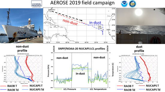
Investigating NUCAPS Skill in Profiling Saharan Dust for Near-Real-Time Forecasting
Abstract
:1. Introduction
2. Materials and Methods
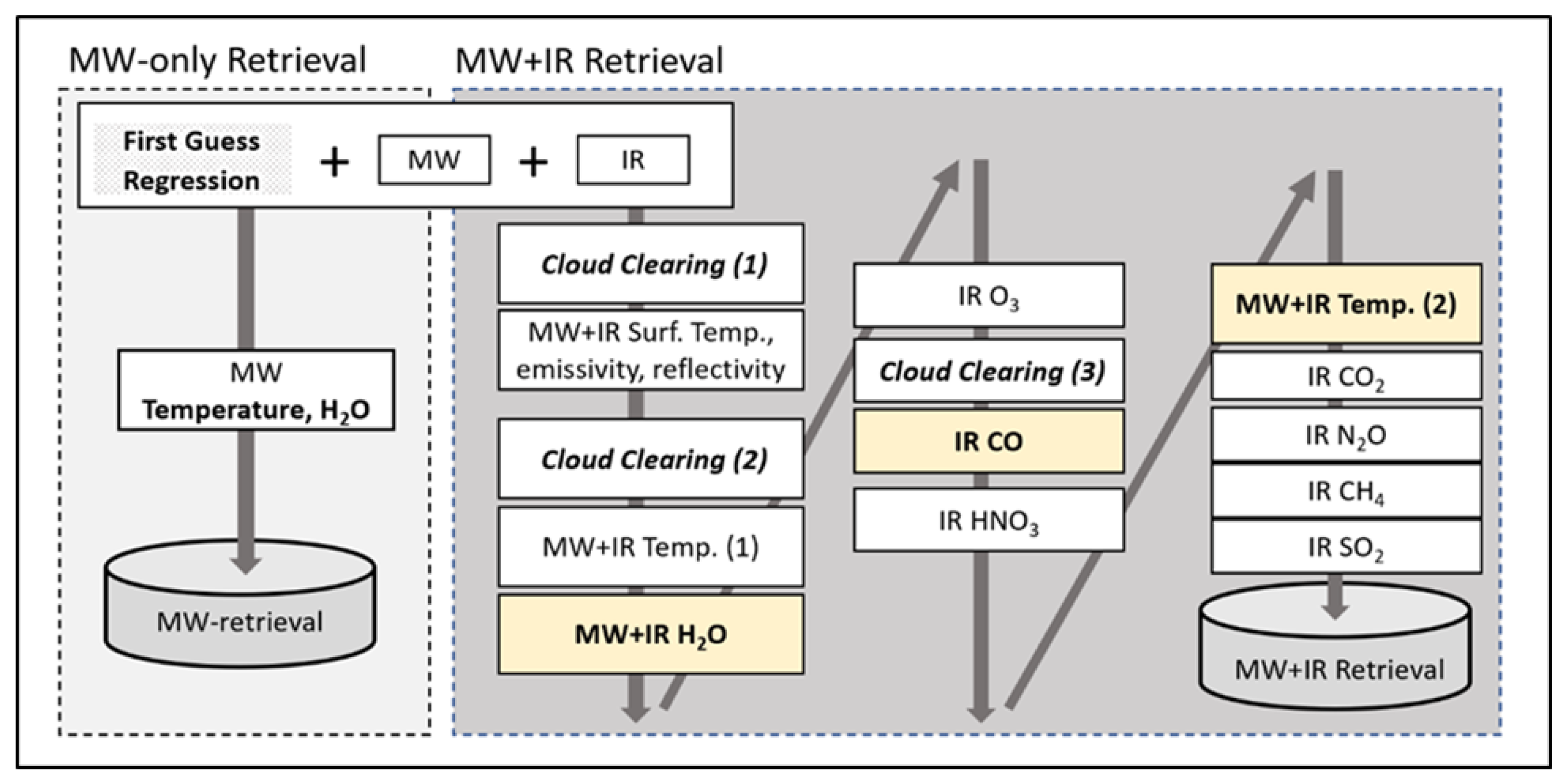
2.1. NUCAPS
2.2. Visible Infrared Imaging Radiometer Suite (VIIRS)
2.3. Cloud-Aerosol Lidar with Orthogonal Polarization (CALIOP)
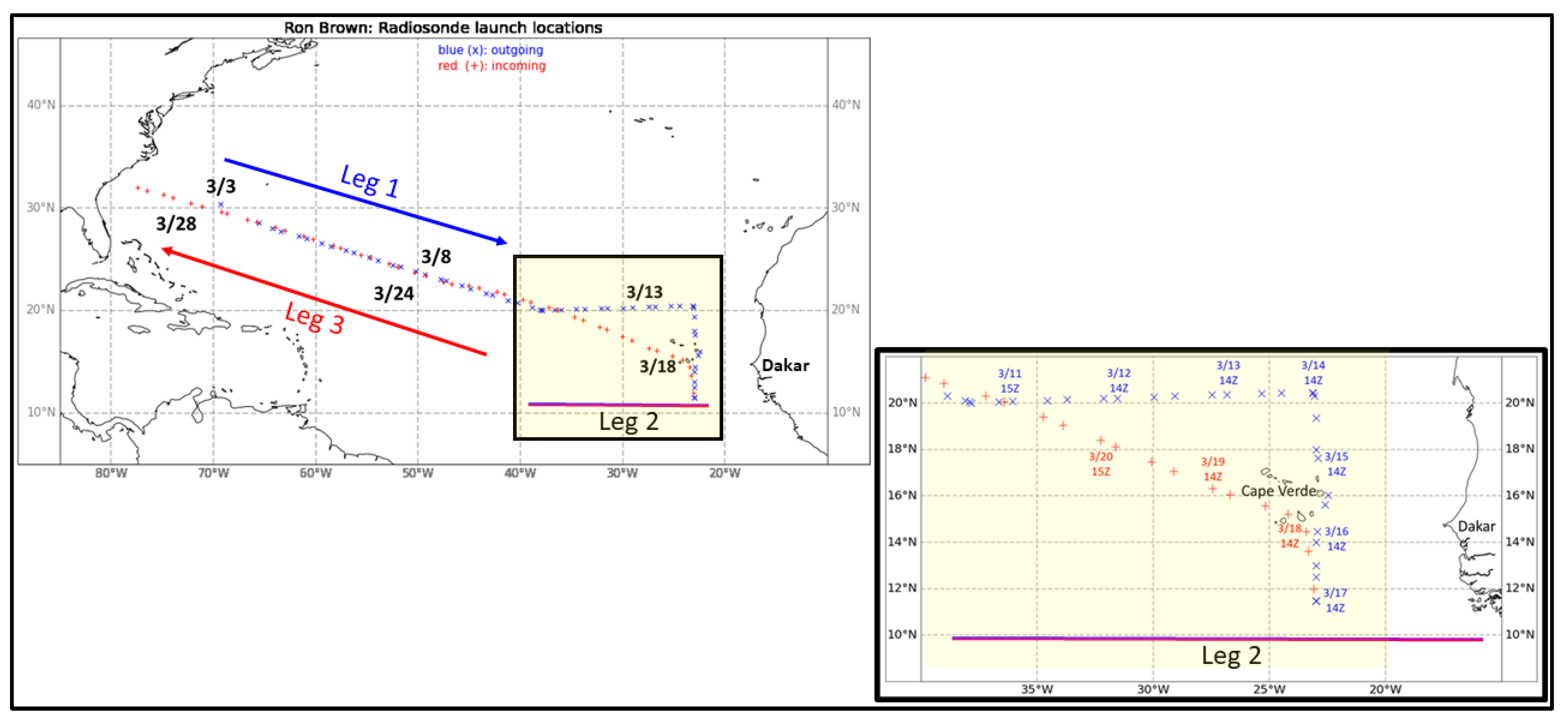
2.4. Radiosondes from the AEROSE Field Campaign and Their Collocations with NUCAPS Sounding Profiles
2.5. Aerosol Robotic Network (AERONET)
2.6. Model Support
2.7. Method of Comparing NUCAPS to Ron Brown RAOB Observations
3. Results
3.1. Case Studies of Dust and Non-Dust Environments
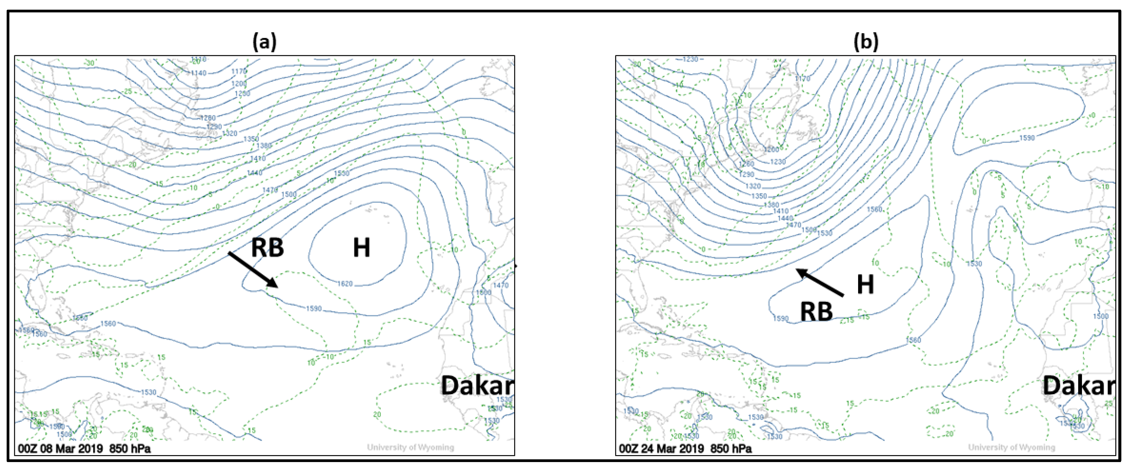
3.1.1. Non-Dust (Background) Profiling: 8 March and 24 March
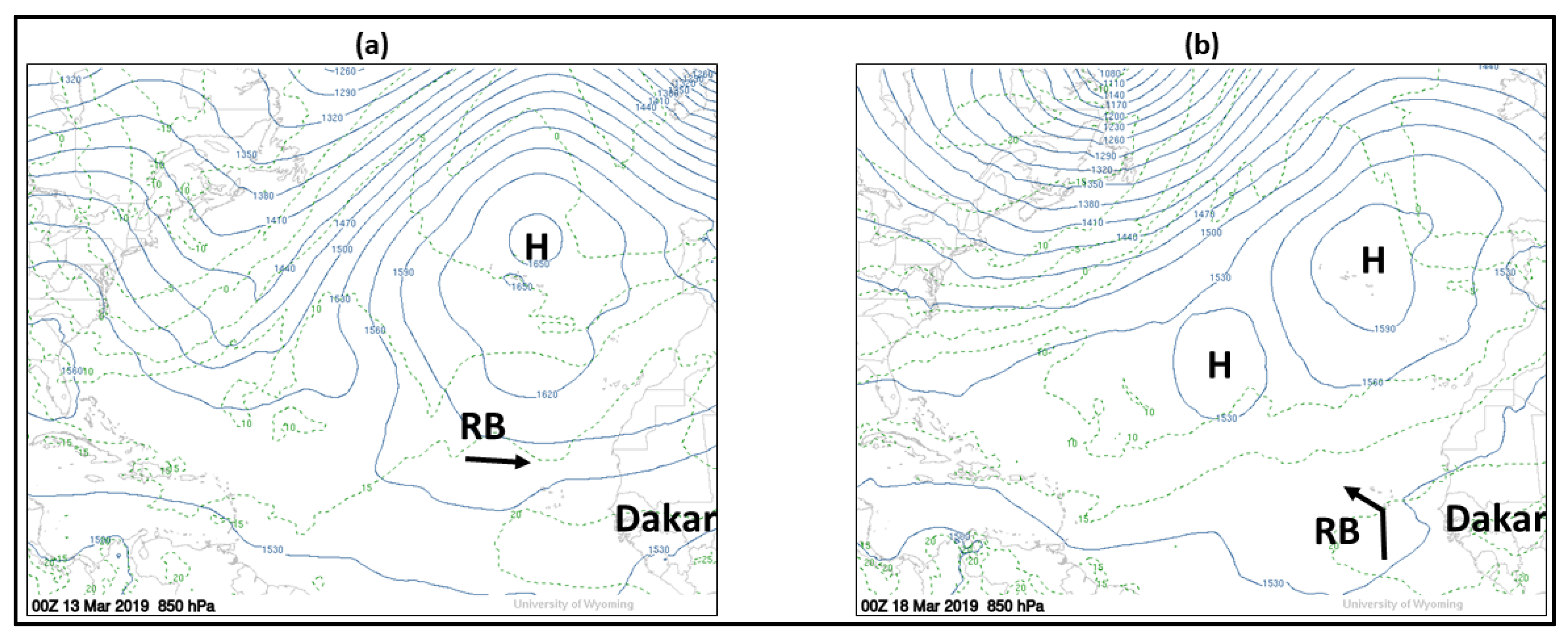
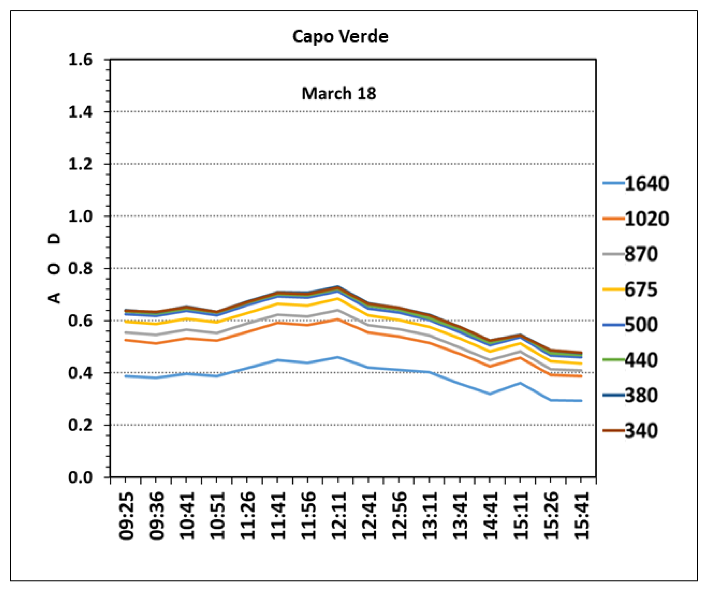
3.1.2. In-Dust Profiling: 13 March and 18 March
3.1.3. Summary
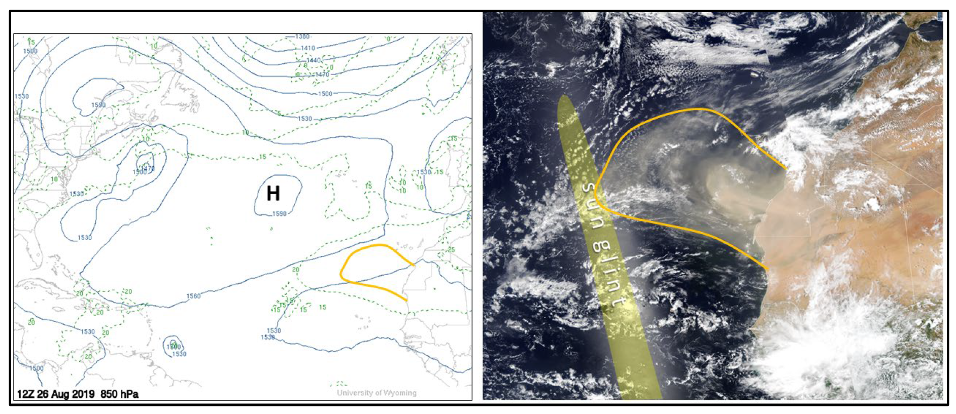
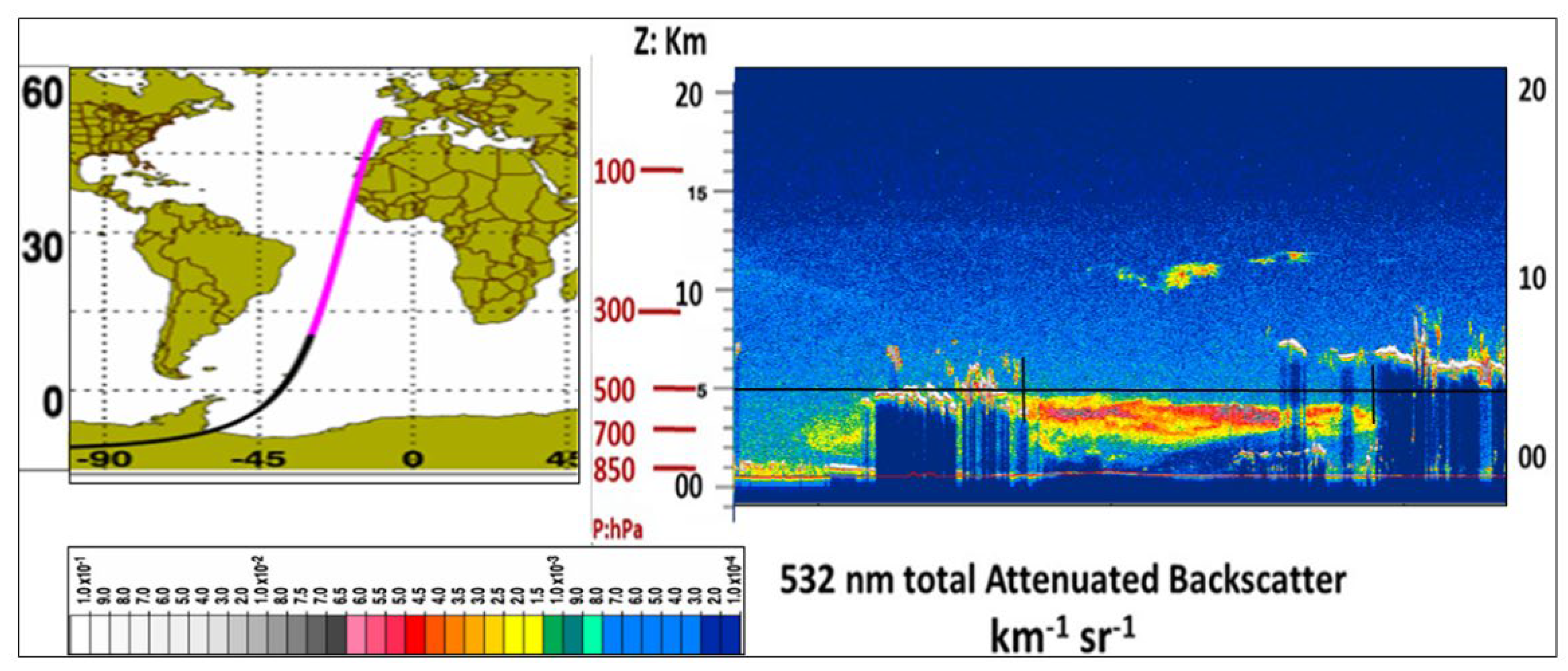
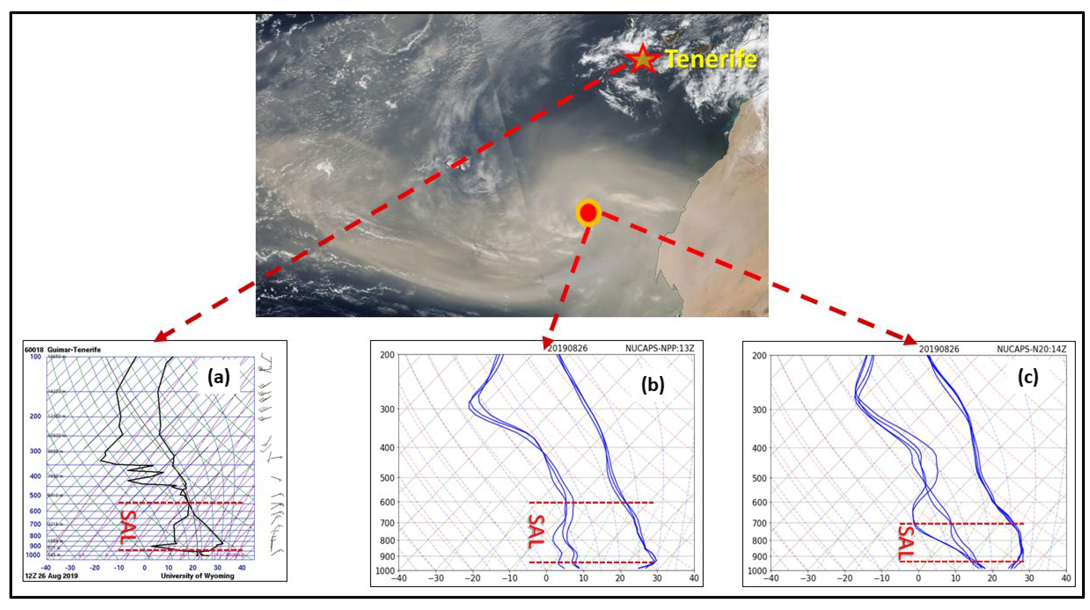
3.2. Applying NUCAPS to Profile Strong SAL Outflow
3.3. Validation of NUCAPS during AEROSE
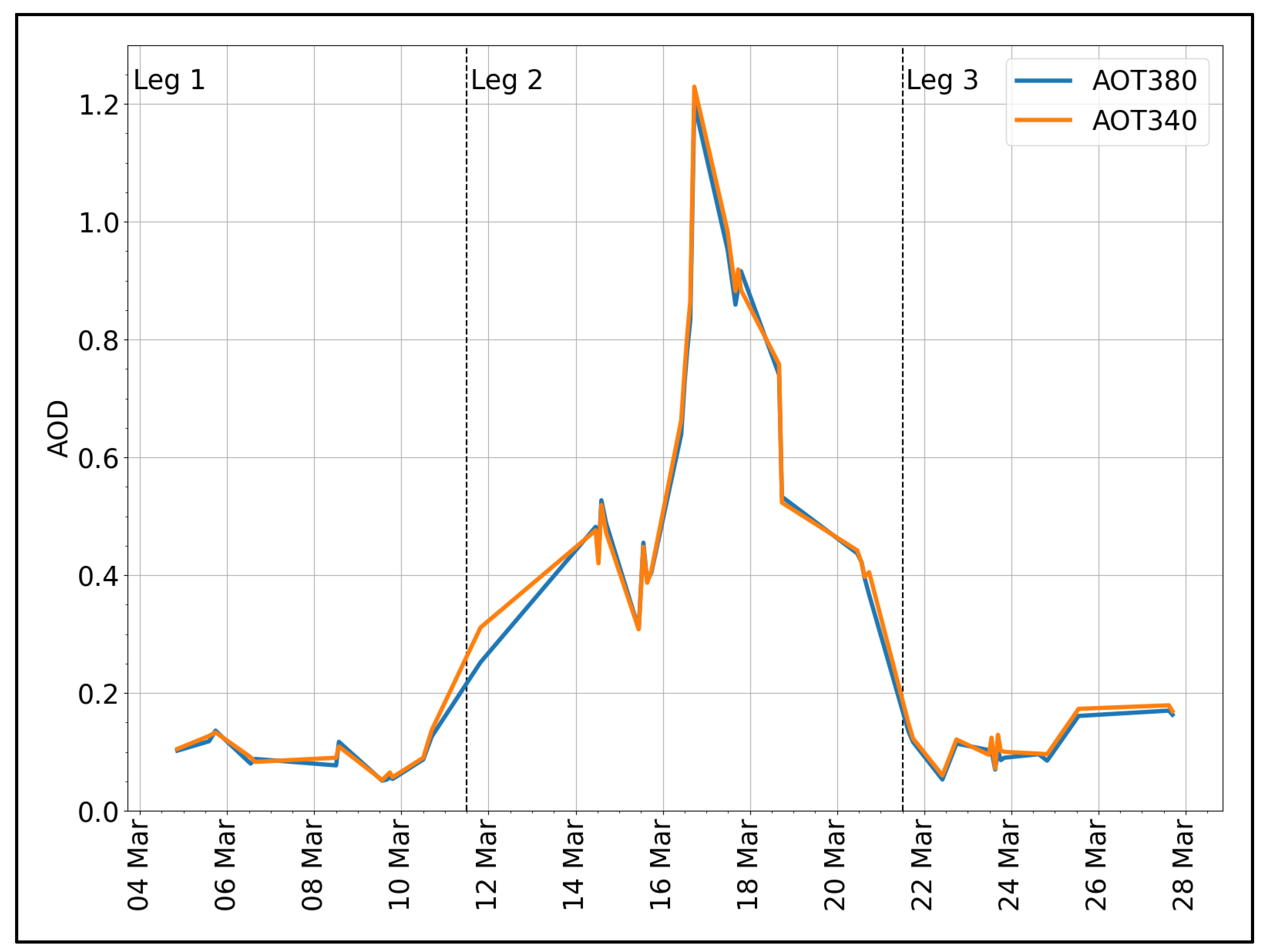
3.3.1. Separating Dust from Non-Dust Conditions
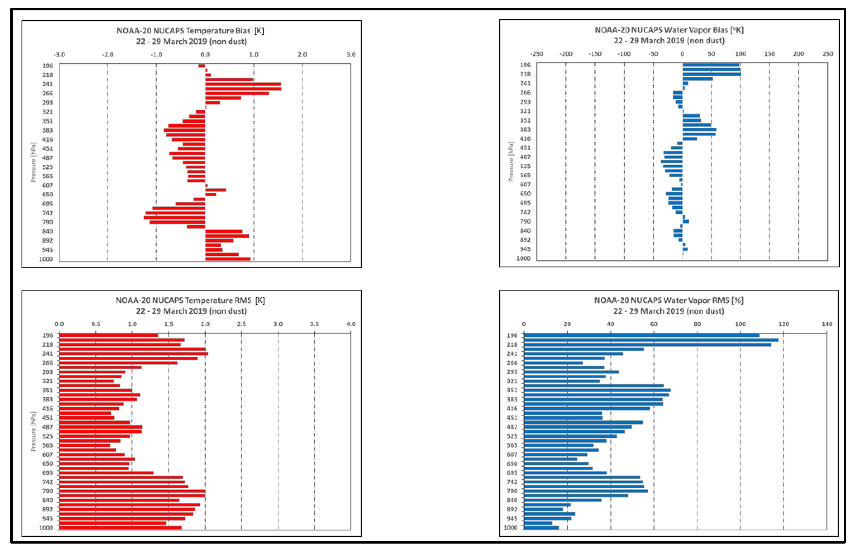
3.3.2. NOAA-20 NUCAPS Temperature and Water Vapor Comparisons with RAOBs
3.3.3. LCL Comparisons between the Ron Brown RAOBS and NUCAPS
4. Conclusions
Author Contributions
Funding
Acknowledgments
Conflicts of Interest
Appendix A
| Acronym | Expansion | Brief Description |
| AERONET | AErosol RObotic NETwork | Federation of ground-based remote sensing aerosol networks |
| AEROSE | Saharan dust AERosols and Ocean Science Expeditions | Trans-Atlantic field campaigns conducted onboard the NOAA Ship Ronald H. Brown designed to explore African air mass outflows and their impacts on climate, weather, and environmental health |
| ATMS | Advanced Technology Microwave Sounder | Satellite hyperspectral microwave sounder |
| AVMP | atmospheric vertical moisture profile | Environmental data records of moisture soundings retrieved by NUCAPS |
| AVTP | atmospheric vertical temperature profile | Environmental data records of temperature soundings retrieved by NUCAPS |
| AWIPS-II | Advanced Weather Interactive Processing System | Meteorological display and analysis package developed and operated by the National Weather Service (second version) |
| CALIPSO-CALIOP | Cloud-Aerosol Lidar and Infrared Pathfinder Satellite Observation—Cloud-Aerosol Lidar with Orthogonal Polarization | Two-wavelength (532 nm and 1064 nm) polarization-sensitive lidar that provides high-resolution vertical profiles of aerosols and clouds. |
| CAPE | Convective Available Potential Energy | Measure of the amount of energy available for atmospheric convection |
| CO, HNO3, O3, CH4, SO2 | Carbon Monoxide, Nitric acid, Ozone, Methane, Sulfur Dioxide | Trace gases sensed by NUCAPS |
| CrIS | Cross-track Infrared Sounder | Satellite hyperspectral Infrared sounders |
| EDR | Environmental Data Records | Weather products produced by NOAA for operational use to NWS and for research applications |
| FOR | Field Of Regard | Total area that can be captured by a satellite sensor |
| GFS | Global Forecast System (GFS) | National Centers for Environmental Prediction (NCEP) weather forecast model that generates data for atmospheric and land-soil variables |
| GRUAN | Global Climate Observing System (GCOS) Reference Upper-Air Network | International reference observing network of sites measuring essential climate variables above Earth’s surface |
| IR | InfraRed | Part of electromagnetic spectrum that ranges in wavelength from 750 nm to 1 mm |
| JPSS | Joint Polar Satellite System | NOAA section focusing on low earth orbiting satellites and operations |
| LCL | Lifting Condensation Level | Level in atmosphere at which a parcel becomes saturated. It can be used as a reasonable estimate of cloud base height when parcels experience forced (very convective) ascent |
| LEO | Low earth orbiting satellites | Satellites that orbit around Earth with a period of 128 min or less (making at least 11.25 orbits per day) and an eccentricity less than 0.25 |
| MetOp | Meteorological Operational satellite | European low earth orbiting satellites that monitor the climate and improve weather forecasts. |
| MW | MicroWave | Part of electromagnetic spectrum that ranges in wavelength from 1 mm to 1 m |
| NOAA-20 | NOAA low earth orbiting satellite | Named JPSS-1 prior to launch, is first of NOAA latest generation of U.S. polar-orbiting, non-geosynchronous, environmental satellites called the Joint Polar Satellite System. |
| NPROVS | NOAA Products Validation System | |
| NTAB | North Tropical Atlantic Basin | Atlantic ocean basin (open water) that stretches between the US and Caribbean Islands eastward to Africa, north the equator |
| NUCAPS | NOAA Unique Combined Atmospheric Processing System | Algorithm used to process temperature and moisture soundings from hyperspectral infrared and microwave sounders |
| PM, PM10, PM2.5 | Particle Measurements | Particle Measurements in general (PM), the size of 10 μm PM10) or 2.5 μm (PM2.5) |
| RAOB | RAwinsonde OBservation | Aatmospheric sounding consisting of a helium-filled balloon that carries an instrument that measures temperature, pressure, moisture, and winds |
| SAL | Saharan Air Layer | Elevated air mass that originates over the African desert that often carries Saharan dust over the tropical Atlantic Ocean |
| SNPP | Suomi National Polar-orbiting Partnership | JPSS prior to launch is US low earth orbiting satellite that started the next generation of JPSS high resolution and fidelity satellites |
| VIIRS | Visible Infrared Imaging Radiometer Suite | Sensor onboard the JPSS series of satellites that are applied toward operational environmental monitoring and numerical weather forecasting |
References
- Prospero, J.M.; Delany, A.C.; Delany, A.C.; Carlson, T.N. The discovery of African dust transport to the Western Hemisphere and the Saharan air layer: A history. Bull. Am. Meteorol. Soc. 2021, 102, E1239–E1260. [Google Scholar] [CrossRef]
- Lara, M.; Akinbami, L.; Flores, G.; Morgenstern, H. Heterogeneity of childhood asthma among Hispanic children: Puerto Rican children bear a disproportionate burden. Pediatrics 2006, 117, 43–53. [Google Scholar] [CrossRef] [PubMed]
- Ortiz-Martinez, M.; Rivera-Ramírez, E.; Méndez-Torres, L.; Jiménez-Vélez, B.D. Role of Chemical and Biological Constituents of PM10 from Saharan Dust in the Exacerbation of Asthma in Puerto Rico; University of Puerto Rico-Medical Sciences Campus: San Juan, Puerto Rico, 2010. [Google Scholar]
- Kotsyfakis, M.; Zarogiannis, S.G.; Patelarou, E. The health impact of Saharan dust exposure. Int. J. Occup. Med. Environ. Health 2019, 32, 749–760. [Google Scholar] [CrossRef] [PubMed]
- Divakarla, M.G.; Pryor, K.; Ho, S.P.; Barnet, C.; Tan, C.; Wilson, M.; Nalli, N.; Zhu, T.; Warner, J.; Wang, T.; et al. NUCAPS Atmospheric Composition and Trace Gas Products: Performance, Recent Advances, and Future Improvements. In Proceedings of the 102nd American Meteorological Society Annual Meeting, AMS, Virtual, 23–27 January 2022. [Google Scholar]
- Susskind, J.; Barnet, C.D.; Blaisdell, J.M. Retrieval of atmospheric and surface parameters from AIRS/AMSU/HSB data in the presence of clouds. IEEE Trans. Geosci. Remote Sens. 2003, 41, 390–409. [Google Scholar] [CrossRef]
- Smith, N.; Barnet, C.D. Uncertainty Characterization and Propagation in the Community Long-Term Infrared Microwave Combined Atmospheric Product System (CLIMCAPS). Remote Sens. 2019, 11, 1227. [Google Scholar] [CrossRef]
- Bloch, C.; Knuteson, R.O.; Gambacorta, A.; Nalli, N.R.; Gartzke, J.; Zhou, L. Near-real-time surface-based CAPE from merged hyperspectral IR satellite sounder and surface meteorological station data. J. Atmos. Ocean. Tech. 2019, 58, 1613–1631. [Google Scholar] [CrossRef]
- Maddy, E.S.; Barnet, C.D. Vertical Resolution Estimates in Version 5 of AIRS Operational Retrievals. IEEE Trans. Geosci. Remote Sens. 2008, 46, 2375–2384. [Google Scholar] [CrossRef]
- Weaver, G.M.; Smith, G.M.; Smith, N.; Berndt, E.B.; White, K.D.; Dostalek, J.F.; Zavodsky, B.T. Addressing the Cold Air Aloft Aviation Challenge with Satellite Sounding Observations. J. Oper. Meteor. 2019, 7, 138–152. [Google Scholar] [CrossRef]
- Nalli, N.R.; Gambacorta, A.; Liu, Q.; Barnet, C.D.; Tan, C.; Iturbide-Sanchez, F.; Reale, T.; Sun, B.; Wilson, M.; Borg, L.; et al. Validation of atmospheric profile retrievals from the SNPP NOAA-Unique Combined Atmospheric Processing System. Part 1: Temperature and moisture. IEEE Trans. Geosci. Remote Sens. 2018, 56, 180–190. [Google Scholar] [CrossRef]
- Esmaili, R.B.; Smith, N.; Berndt, E.B.; Dostalek, J.F.; Kahn, B.H.; White, K.; Barnet, C.D.; Sjoberg, W.; Goldberg, M. Adapting Satellite Soundings for Operational Forecasting within the Hazardous Weather Testbed. Remote Sens. 2020, 12, 886. [Google Scholar] [CrossRef] [Green Version]
- Nalli, N.R.; Barnet, C.D.; Reale, T.; Liu, Q.; Morris, V.R.; Spackman, J.R.; Joseph, E.; Tan, C.; Sun, B.; Tilley, F.; et al. Satellite sounder observations of contrasting tropospheric moisture transport regimes: Saharan air layers, Hadley cells, and atmospheric rivers. J. Hydrometeorol. 2016, 17, 2997–3006. [Google Scholar] [CrossRef]
- Moulin, C.; Gordon, H.R.; Banzon, V.F.; Evans, R.H. Assessment of Saharan dust absorption in the visible from SeaWiFS imagery. J. Geophys. Res. Atmos. 2001, 106, 18239–18249. [Google Scholar] [CrossRef]
- Di Sarra, A.; Di Iorio, T.; Cacciani, M.; Fiocco, G.; Fua, D. Saharan dust profiles measured by lidar at Lampedusa. J. Geophys. Res. Atmos. 2001, 106, 10335–10347. [Google Scholar] [CrossRef]
- Kalluri, S. Exploring the Future of Infrared Sounding: Outcomes of a NOAA-NESDIS Virtual Workshop. Bull. Am. Meteorol. Soc. 2022. [Google Scholar] [CrossRef]
- Berndt, E.; Smith, N.; Burks, J.; White, K.; Esmaili, R.; Kuciauskas, A.; Duran, E.; Allen, R.; LaFontaine, F.; Szkodzinski, J. Gridded satellite sounding retrievals in operational weather forecasting: Product description and emerging applications. Remote Sens. 2020, 12, 3311. [Google Scholar] [CrossRef]
- Winker, D.M.; Vaughan, M.A.; Omar, A.; Hu, Y.; Powell, K.A.; Liu, Z.; Hunt, W.H.; Young, S.A. Overview of the CALIPSO Mission and CALIOP Data Processing Algorithms. J. Atmos. Oceanic Technol. 2009, 26, 2310–2323. [Google Scholar] [CrossRef]
- Nalli, N.R.; JosEph, E.; Morris, V.R.; Barnet, C.D.; Wolf, W.W.; Wolfe, D.; Minnett, P.J.; Szczodrak, M.; Izaguirre, M.A.; Lumpkin, R.; et al. Multiyear observations of the tropical Atlantic atmosphere: Multidisciplinary applications of the NOAA Aerosols and Ocean Science Expeditions. Bull. Am. Meteorol. Soc. 2011, 92, 765–789. [Google Scholar] [CrossRef]
- Morris, V.; Clemente-Colón, P.; Nalli, N.R.; Joseph, E.; Armstrong, R.A.; Detrés, Y.; Goldberg, M.D.; Minnett, P.J.; Lumpkin, R. Measuring trans-Atlantic aerosol transport from Africa. Eos Trans. Am. Geophys. Union 2006, 87, 565–571. [Google Scholar] [CrossRef]
- Kawai, Y.; Oshima, M.K.K.; Hori, M.E.; Inoue, J. Comparison of Vaisala radiosondes RS41 and RS92 launched over the oceans from the Arctic to the tropics. Atmos. Meas. Tech. 2017, 10, 2485–2498. [Google Scholar] [CrossRef]
- Jensen, M.P.; Holdridge, D.J.; Survo, P.; Lehtinen, R.; Baxter, S.; Toto, T.; Johnson, K.L. Comparison of Vaisala Radiosondes RS41 and RS92 at the ARM Southern Great Plains Site. Atmos. Meas. Tech. 2016, 9, 3115–3129. [Google Scholar] [CrossRef] [Green Version]
- Sun, B.; Reale, A.; Schroeder, S.; Pettey, M.; Smith, R. On the accuracy of Vaisala RS41 versus RS92 upper-air temperature observations. J. Atmos. Ocean. Tech. 2019, 36, 635–653. [Google Scholar] [CrossRef]
- Sun, B.; Calbet, X.; Reale, A.; Schroeder, S.; Bali, M.; Smith, R.; Pettey, M. Accuracy of Vaisala RS41 and RS92 upper tropospheric humidity compared to hyperspectral satellite infared measurements. J. Remote Sens. 2021, 13, 173. [Google Scholar] [CrossRef]
- Sun, B.; Reale, A.; Pettey, M.; Smith, R. NOAA Products Validation System. In Field Measurements for Passive Environmental Remote Sensing; Chapter 16 of the book; Nalli, N., Liu, M., Borg, L., Eds.; Elsevier: Amsterdam, The Netherlands, 2022. [Google Scholar]
- Holbein, B.N.; Eck, T.F.; Shuster, I.; Tanner, D.; Buys, J.P.; Seltzer, A.; Vermonter, E.; Reagan, J.A.; Kaufman, Y.J.; Nakajima, T.; et al. AERONET—A federated instrument network and data archive for aerosol characterization. Remote Sens. Environ. 1998, 66, 1–16. [Google Scholar] [CrossRef]
- Iturbide-Sanchez, F.; da Silva, S.R.S.; Liu, Q.; Pryor, K.L.; Pettey, M.E.; Nalli, N.R. Toward the Operational Weather Forecasting Application of Atmospheric Stability Products Derived from NUCAPS CrIS/ATMS Soundings. IEEE Trans. Geosci. Remote Sens. 2018, 56, 4522–4545. [Google Scholar] [CrossRef]
- Riemer, N.; Doherty, O.M.; Hameed, S. On the variability of African dust transport across the Atlantic. Geophys. Res. Lett. 2006, 33, L13814. [Google Scholar] [CrossRef]
- Maddy, E.S.; DeSouza-Machado, S.; Nalli, N.R.; Barnet, C.D.; Strow, L.L.; Wolf, W.W.; Xie, H.; Gambacorta, A.; King, T.S.; Joseph, E.; et al. On the effect of dust aerosols on AIRS and IASI operational level 2 products. Geophys. Res. Lett. 2012, 39, L10809. [Google Scholar] [CrossRef]
- Luo, B.; Minnett, P.J.; Zuidema, P.; Nalli, N.R.; Akella, S. Saharan dust effects on North Atlantic sea-surface skin temperatures. J. Geophys. Res. Ocean. 2021, 126, e2021JC017282. [Google Scholar] [CrossRef]







| Dates | NUCAPS Overpass Times (UTC) | RAOB Launch Times (UTC) | Ron Brown Positions Relative to RAOB Launches | ||
|---|---|---|---|---|---|
| SNPP | NOAA-20 | Latitude | Longitude | ||
| 8 March (non-dust) | 04:16 | 05:08 | 04:35 | 23.52°N | 49.37°W |
| 15:30 | 16:21 | 15:50 | 22.88°N | 47.25°W | |
| 24 March (non-dust) | 04:17 | 05:08 | 03:04 | 23.77°N | 50.35°W |
| 16:21 | 16:21 | 15:58 | 24.59°N | 52.86°W | |
| 13 March (dust) | 02:43 | 03:34 | 02:26 | 29.30°N | 29.06°W |
| 15:36 | 14:45 | 14:18 | 20.37°N | 26.82°W | |
| 18 March (dust) | 02:50 | 03:42 | 02:26 | 12.00°N | 23.09°W |
| 13:58 | 14:50 | 14:29 | 14.46°N | 23.44°W | |
| Atmospheric Vertical Temperature Profile (AVTP) | ||
|---|---|---|
| cloud-free to partly cloudy | ||
| threshold | objective | |
| Surface to 300 hPa | 1.6 K | 0.5 K |
| Atmospheric Vertical Moisture Profile (AVMP) | ||
| cloud-free to partly cloudy | ||
| threshold | objective | |
| Surface to 600 hPa | greater of 20% or 0.2 gkg−1 | 10% |
Publisher’s Note: MDPI stays neutral with regard to jurisdictional claims in published maps and institutional affiliations. |
© 2022 by the authors. Licensee MDPI, Basel, Switzerland. This article is an open access article distributed under the terms and conditions of the Creative Commons Attribution (CC BY) license (https://creativecommons.org/licenses/by/4.0/).
Share and Cite
Kuciauskas, A.; Reale, A.; Esmaili, R.; Sun, B.; Nalli, N.R.; Morris, V.R. Investigating NUCAPS Skill in Profiling Saharan Dust for Near-Real-Time Forecasting. Remote Sens. 2022, 14, 4261. https://doi.org/10.3390/rs14174261
Kuciauskas A, Reale A, Esmaili R, Sun B, Nalli NR, Morris VR. Investigating NUCAPS Skill in Profiling Saharan Dust for Near-Real-Time Forecasting. Remote Sensing. 2022; 14(17):4261. https://doi.org/10.3390/rs14174261
Chicago/Turabian StyleKuciauskas, Arunas, Anthony Reale, Rebekah Esmaili, Bomin Sun, Nicholas R. Nalli, and Vernon R. Morris. 2022. "Investigating NUCAPS Skill in Profiling Saharan Dust for Near-Real-Time Forecasting" Remote Sensing 14, no. 17: 4261. https://doi.org/10.3390/rs14174261
APA StyleKuciauskas, A., Reale, A., Esmaili, R., Sun, B., Nalli, N. R., & Morris, V. R. (2022). Investigating NUCAPS Skill in Profiling Saharan Dust for Near-Real-Time Forecasting. Remote Sensing, 14(17), 4261. https://doi.org/10.3390/rs14174261


