Abstract
This paper addresses an experimental approach to the archaeological study of Roman camps in NW Iberia using ground-penetrating radar (henceforth GPR). The main goal is to explore the capabilities of GPR to extract datasets from ephemeral features, such as temporary camps or siege works, among others. This information aims to maximise the data available before excavation, orienting it to areas that could provide good results in terms of feature detection and contrast between soil matrix and archaeological deposits. This paper explores the potential of the GPR approach and volumetric data visualisation to improve our understanding of four ephemeral sites: Alto da Raia (Montalegre, Portugal–Calvos de Randín, Spain), Sueros de Cepeda (Villamejil, Spain), Los Andinales (Villsandino, Spain), and Villa María (Sasamón, Spain). Despite the focus of this paper, other survey techniques (namely LiDAR, aerial photography, and magnetometry) were used in combination with GPR. Further excavation of the sites provided ground truthing for all data remotely gathered.
1. Introduction
In recent years, the research on Roman military camps in the north-western Iberian Peninsula has been growing thanks to the release and availability of numerous geospatial datasets. In Portugal and Spain, the open access to aerial photography and airborne LiDAR data adds to other freely available satellite data from international platforms such as Google Earth, Yahoo, Bing, or Apple Maps [1,2,3,4,5,6]. The growing interest in applying new methodologies to improve the existing datasets has resulted in the detection of several Roman military installations of a temporary nature, which are often impossible to detect through more traditional approaches—such as field surveys—given their low preservation degree. To a large extent, these sites may be linked to the early stages of the Roman expansion in the area, unveiling previously unknown conquest and other scenarios of interaction between the Roman and indigenous worlds [2].
Aerial and satellite imagery from a diverse range of public and private satellite constellations is fostering the mapping of archaeological traces worldwide [7,8]. The advances in site detection are largely dependent on two main factors: the availability of suitable open-access geospatial datasets (LiDAR, satellite, and airborne imagery) and the capability of the different researchers to produce data on their own (UAV-derived DEM and orthophotography). Some finds occurred within systematic research programs, often using artificial intelligence (AI), machine learning, or convolutional neural networks [9,10]; others are serendipitous discoveries derived from scouting recently available remote sensing datasets. Identifying archaeological traces belonging to the activities of the Roman army during the conquest process is challenging for different reasons. Firstly, military field installations do not exactly stand out for their expressiveness in the archaeological record [11,12]. Designed to be briefly occupied, their most distinctive features were defensive ramparts, parapets, palisades, ditches, and tents, of which very little remains today. In the absence of material culture (pottery, metallic objects, etc.), the characterisation of these sites usually relies on identifying certain morphological elements, often considered canonical. Defensive perimeters in the form of a playing card (that is, a square or rectangle with rounded corners) or the presence of features such as claviculae (prolongations of the ramparts forming a quarter of a circle) or tituli (small, external traverse obstacles) guarding the gates are among the most recognisable elements. Secondly, we must consider the limitations derived from uneven dataset coverage in Spain and Portugal (especially concerning LiDAR data) and the geospatial product’s spatial, spectral, and temporal resolutions. Since Roman military camps usually were huge enclosures now divided between several plots, we must further consider the moment of data capture in agricultural areas with different crops at different stages of the phenological cycle. Since vegetation’s growth and degree of maturity significantly impact the visibility of the shallow underground archaeological remains, these factors limit the identification of the Roman military sites’ defensive perimeter and the understanding of their internal distribution.
Even if the growing availability of digital imagery from public and private sources fosters the recognition of previously unknown archaeological traces, only a few of these coverages are useful for archaeological purposes.
This paper aims to tackle the study of the ephemeral traces of Roman temporary camps by applying a multi-modal approach in which remote sensing and geophysical survey are key. The overall aim is threefold: (1) to characterise archaeological features previously detected by other remote sensing methods; (2) to evaluate their preservation degree or physical characteristics through the interpretation of the geophysical data; and eventually, (3) to maximise the excavation results driven by GPR data. The application of the GPR survey in Roman temporary camps as proposed in this paper is innovative. In the Iberian Peninsula, most previous efforts have concentrated on studying permanent military structures [13] (Figure 1), chiefly using other techniques such as extensive magnetometry surveys.
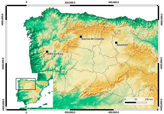
Figure 1.
Location of the Roman camps studied in this paper within north-western Iberia. EPSG: 25830.
In the following lines, we will describe our remote sensing approach, from studying large areas of interest (using LiDAR or aerial/satellite imagery) to site-based strategies, including geophysical surveys and test-pit excavation. After that, we will detail the GPR approach to document the ephemeral traces of Roman temporary camps in four case studies in two countries (Portugal and Spain). We will emphasise the capabilities of volumetric visualisation of geophysical data alongside traditional radargram and slice interpretation to obtain information about subtle changes in soil composition and the geometry of archaeological features, either positive (structures) or negative (trenches). An analysis of the results of the GPR survey in each site will follow. Finally, we will discuss the outcomes of our archaeological approach.
2. Materials and Methods
One of the main goals of this paper is to introduce a workflow based on non-invasive approaches with ground-truthing. The exponential growing interest in the Roman conquest of the Iberian northwest has precipitated the development and application of a common research programme and the combined analysis of study cases at different levels [7,14,15]. The intended methodology aligns with existing archaeological approaches to studying the Roman military presence elsewhere in Europe [16,17,18,19,20,21]. This workflow comprises four consecutive stages: (1) remote sensing; (2) geophysical survey; (3) ground-truthing via excavation; (4) sampling and archaeometric analyses. On this occasion, we will focus on the first three stages.
The first stage of studying Roman military landscapes relies on remote sensing technologies (namely airborne LiDAR, aerial photography, and satellite imagery). LiDAR has revolutionised archaeological research in the Iberian Peninsula, where upland and forested regions were previously ill-explored by scholars. New archaeological evidence was brought to light thanks to the critical analysis of LiDAR-derived datasets from two different coverages from the Spanish National Geographic Institute (IGN) through the PNOA project (National Aerial Orthophotography Plan). This phenomenon challenged the traditional narratives on the expansion of the Roman state and led to a completely renewed archaeological scenario [4,6,7,22,23,24]. As is often the case, new evidence raises new research questions—notably the chronological sequence of those features that appear as palimpsests on the landscape still needs to be clarified.
The potential of LiDAR datasets for detecting Roman military sites is severely limited in flattened areas or large agricultural fields where the archaeological sites rarely retain topographic expression [25]. That is precisely the case for many territories located north of the Douro River, which comprise a vast sector of our study area. The research strategy followed a two-step process when dealing with these plain areas [7]. Firstly, crop marks were detected using national and international aerial and satellite coverages such as those from the Spanish IGN-PNOA or private, commercial missions. Secondly, the acquisition of high-resolution UAV images led to generating photogrammetric RGB and infrared orthophotos and digital surface models (DSM). While the imagery provided by public or private entities is produced at any time of the year, the UAV flights are carefully planned according to the best moments of the crop cycle to maximise information. Nevertheless, conditions can easily vary due to anthropogenic and natural causes, the reason why the surveys are carried out yearly. The increasing spatial, spectral, and temporal resolution of the imagery coverage leads to more accurate documentation of the archaeological features and the potential discovery of new sites.
This paper presents the application of GPR to counter the limitations and variability of the different remote sensing approaches to studying Roman military camps in north-western Iberia (Figure 1 and Figure 2; see Table 1). We aim to increase our understanding of previously mapped structures and detect new features that could help better characterise these sites, i.e., defensive elements guarding the gates. Although other geophysical techniques (fluxgate magnetometer) were used to explore these sites during our field activities, we will focus on the contributions of GPR since its use to document ephemeral structures in Roman military contexts is not as usual [13,26,27].
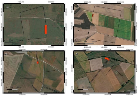
Figure 2.
Location of GPR surveys within case studies presented in the text: (a). Alto da Raia; (b). Sueros de Cepeda; (c). Los Andinales; (d). Villa María (background image: Google Earth). Black lines indicate the proposed outline of the Roman camps. Red areas delimit the GPR survey areas. EPSG: 25830.

Table 1.
Noggin 250 MHz settings and acquisition parameters.
2.1. GPR Survey Methodology
GPR is a well-known geophysical technique in archaeological research [19,20,28,29,30]. When combined with other geophysical methods (i.e., magnetometer, electric resistivity, or electromagnetic induction), it has been proven helpful in studying Roman military sites [13,26,27,31,32,33]. However, the spectacular results obtained in permanent military bases tend to make us forget that most archaeological sites related to the Roman army were ephemeral installations briefly occupied, i.e., marching camps, structures related to siege scenarios, construction camps, etc., [34]. In our case, solid stone structures or other elements designed to last longer periods were not expected. In the Iberian Peninsula, the application of GPR for studying sites linked with the Roman military expansion is rather restricted, although some specific study cases highlight the capabilities of this technique [26].
The implementation of GPR surveys in the study cases described in Section 2.2 took place after initial site plans were produced by other means. Therefore, the application of GPR was oriented to the investigation of specific features, aiming to assess the morphological characteristics of ephemeral structures preserved at those sites and to maximise our success in capturing information coming from archaeological excavations conducted right after the geophysics, either in the same area or as close as possible to the GPR surveyed area.
To this end, we used a Noggin 250 MHz system from Sensors and Software mounted on a Smart Car by the same company (Figure 3 and Table 2). This system was first tested and systematically used in surveying the Roman city of Segisamo (Sasamón). Although this site will not be discussed in this paper, the technique has provided good results in a similar geological and pedological context to the Roman army siege scenario described below in Section 2.2.3 [35]. The 250 MHz antenna provides a good equilibrium between resolution and penetration depth. Besides our first-hand experiments in the Sasamón area, Seren et al. [36] offer a comparative perspective of different antenna frequencies and providers in which this GPR system is well-positioned.
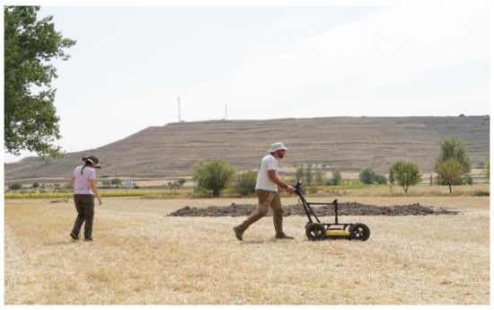
Figure 3.
GPR survey in August 2021 at Villa María with Noggin 250 Mhz. In the background, the oppidum of Cerro de Castarreño, Sasamón.
Table 2.
Roman camp locations, morphology, and extent of the survey areas analysed in this paper.
The survey was organised following georeferenced grids of various sizes set up on the ground with RTK GNSS instruments. These grids were surveyed only in the direction of the X-axis with a 50 cm separation between lines. The GPR raw data was processed in Ekko Project v.5 (Sensors and Software): wave velocity was calibrated using hyperbola fitting, and depth slices with a maximum resolution of 5 cm per pixel were eventually interpolated. The data filtering process mirrors the work performed successfully by other scholars using similar equipment [37,38], including Dewow filter, gain correction, background removal, and bandpass filtering. Both visualisation and interpretation were made in QGIS 3.22.
Another aspect that could be considered for future geophysical surveys of Roman camps is the possibility of visualising volumetric data using software such as Voxler (Goldersoftware) [39]. On this occasion, different visualisations were experimented with, namely slices cut through volumetric renders. Secondly, Face Render was used to isolate values related to the ditches’ fillings, which appear as low amplitude reflections in the GPR data. Thanks to the Hilbert transform processing, the visualisation of subtle differences in soil composition could improve the visualization of the fillings located inside the trenches by increasing the resolution of the signal [40]. This process might seem inverse to the usual workflow of isolating high amplitude reflections only to identify built structures.
2.2. Case Studies
The case studies presented here are only a small part of the research developed by our research collective in the last decade [4]. Even if the use of remote sensing and other non-invasive approaches became one of its hallmarks, the romanarmy.eu initiative has carried out detailed studies on some significant archaeological sites involving the on-site surveying and excavation of test trenches to document the stratigraphic sequences of their defensive systems and inner structures, the recovery of material culture and the collection of samples for absolute dating and paleo-environmental studies.
This paper focuses on two isolated sites and one archaeological complex where GPR survey was developed in 2021 (Figure 4). The former are the Roman camps of Alto da Raia (between the municipality of Calvos de Randín in Ourense, Spain, and that of Montalegre, in Vila Real, Portugal) and Sueros de Cepeda (Villamejil, León, Spain). The latter is the siege scenario around the Cerro de Castarreño oppidum (municipalities of Sasamón and Villasandino, Burgos, Spain), where two sectors (Villa María and Los Andinales) will be discussed in detail (see Figure 5) (Table 1 and Table 2).
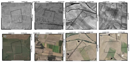
Figure 4.
Layout of the analysed sites drawn on aerial photographs. (1a). Alto da Raia (SPLAL 1949); (1b). Alto da Raia (Google Earth 15 July 2020). (2a). Sueros de Cepeda (USAF 1956); (2b). Sueros de Cepeda (Google Earth 13 September 2017); (3a) Villa María (Sasamón) (USAF 1956); (3b). Villa María (Sasamón) (Google Earth 17 June 2019); (4a). Los Andinales (Villasandino) (USAF 1956); (4b). Los Andinales (Villasandino) (Google Earth 17 June 2019). Note that the images are reproduced at different scales. Black arrows point to the contravallatio system; white arrows point to the circumvallation. EPSG: 25830.
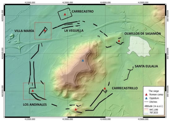
Figure 5.
The siege of Cerro de Castarreño. Late Iron Age oppidum (blue triangles), Roman camps (red triangles), siege structures (black lines), and the extent of the modern-day town of Olmillos de Sasamón (white area). The areas analysed in this paper have been marked with red-dotted lines. EPSG: 25830. JMCG.
2.2.1. Alto da Raia (Calvos de Randín, Ourense, Spain–Montalegre, Vila Real, Portugal)
The Alto da Raia camp (Figure 4(1a,1b)) shows an overall rectangular layout with rounded corners and straight lines connecting them. It was recently discovered thanks to the processing and analysis of the LiDAR data provided by the Spanish IGN-PNOA project. The data made it possible to document a fortified enclosure of approximately 3 ha in size, built on a hill at circa 883 m asl overlooking the valley of the Salas River. The camp of Alto da Raia is located on a Palaeozoic granite and rocky slate zone, with optimal conditions for the GPR survey regarding soil conductivity and even terrain for the equipment configuration (Figure 6). The SPLAL aerial imagery (1949) acquired from the Geospatial Information Centre of the Portuguese Army (CIGeoE) shows that the camp’s location has not been subject to agricultural practices, except for a few areas nearby that no longer serve this purpose.
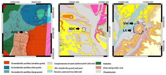
Figure 6.
Main lithologic units in the study areas (after IGN-MAGNA 50.000, sheets 160 and 199) and geological map of Portugal 1:50,000 from LNEG (National Energy and Geology Laboratory) (sheet 02-C–Tourém, 1977). The layout of the analysed sites has been drawn in every case. From left to right: Alto da Raia camp (ADR), Sueros de Cepeda camp (SDC), the siege structures around Cerro de Castarreño (VM-Villa María, and LA-Los Andinales). Images are reproduced at different scales. EPSG: 25830.
The archaeological survey—using LiDAR, UAV-derived photogrammetry (see hillshade visualisation in Figure 7), geophysics (magnetometry and GPR), and excavation—carried out in 2021 validated its characterisation as a Roman military camp. Publication of the results is underway. Although quite flattened on its southern side, an earthen rampart was documented delimiting the site, whereas an external V-shaped ditch complemented the defences. The GPR survey aimed at identifying the eastern entrance to the camp, a feature relevant to deepen the characterisation of the site and to understand its internal structure.
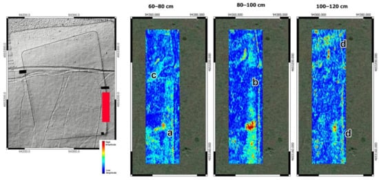
Figure 7.
Indication of GPR survey area in red over drone-DSM (José Alberto Gonçalves, University of Porto). Excavation trenches are marked in black. Depth slices from Alto da Raia’s Roman camp. (a) inner rampart; (b) berm; (c) clavicula; (d) external ditch. EPSG: 25830.
2.2.2. Sueros de Cepeda (Villamejil, León, Spain)
The Roman camp of Sueros de Cepeda (Figure 4(2a,2b)) was discovered using governmental satellite and aerial imagery in 2020 and later published among other new evidence on Roman temporary sites in north-western Iberia [7]. The camp is ca. 13.5 ha in size and was built on an elevated plain area (950 masl) 500 m to the West of the village of Sueros de Cepeda, in the Tuerto River valley. Although its canonical squared, playing-card outline can be easily recognised, no other morphological elements such as gates were detected. The Roman camp is located in a flat agricultural area which is nowadays devoted to cereal, legumes, and corn cultivation. The USAF imagery from 1956 (see Figure 4 top row) shows an important change in the organisation of land division. From the 1960s onwards, small properties were rearranged into larger plots, whereas irrigation infrastructure and new dirt roads were built. The use of heavy machinery in those works affected the preservation of ancient remains. Indeed, this site was detected thanks to crop marks observed through remote sensing, whereas no topographic observations indicate the presence of the Roman camp on the ground. The geological composition is a mixture of sandstone, conglomerates, and clay that originated in the Miocene era (Figure 6).
In addition to geophysics using GPR and fluxgate magnetometer, the 2021 archaeological campaign in Sueros de Cepeda included aerial surveying using UAV, and pedestrian survey, followed by the excavation of two trenches at the site’s defences. Investigations confirmed that a single V-shaped ditch limited the camp and that the earthen, defensive rampart had been razed by constant ploughing. Absolute dating and paleo-environmental samples were also collected. Results from the 2021 investigations have not been published yet, whereas preliminary field reports have been submitted for evaluation to the funding institutions and the regional heritage curator agency. Specifically, the GPR survey goals were to test this methodology in a previously unexplored geological context and to document the camp defences in an area corresponding with the western boundary of the camp, where aerial photographs had not yielded optimal results.
2.2.3. The Siege of Cerro de Castarreño (Sasamón and Villasandino, Burgos, Spain)
Since 2017, the Warscapes project has been investigating several Roman camps around the oppidum of Cerro de Castarreño [41] (Figure 4), which controls a gently undulating plateau (ca. 795 masl) close to the confluence of the Brullés and Odra rivers. The first archaeological features had been documented thanks to previous aerial [42,43] and field surveys [44], although the discovery of the sites analysed here took place during the 2019 and 2020 campaigns. The archaeological features lay on a Holocene zone composted by gravel or loose rock, sand, and clay, influenced by the Brullés River (Figure 6). Areas farther from the river valley are of Miocene origin, similar to the geology of the Sueros de Cepeda camp.
The area is almost exclusively devoted to cereal agriculture (wheat and barley), although some industrial crops for vegetable oil cultivation started in the last few years. The inspection of the USAF imagery (1956) shows a pattern where small field plots were merged into larger units, thus impacting the preservation of archaeological features. Nevertheless, some of the siege structures were already visible close to the Arroyo del Puerco stream in 1956, soon before the land reorganisation started.
Beyond a characterisation based on morphological parallels, these structures’ exact functionality and dating were debated. The systematic aerial survey of the zone using UAVs and new satellite coverages released in 2020 fostered the detection of several traces related to the Roman military presence on a regional scale [7,45,46]. As a result, the evidence previously gathered in the Sasamón and Villasandino municipalities was reinterpreted as a possible siege scenario around the Late Iron Age oppidum of Cerro de Castarreño with remarkable similarities to Alesia [47,48]. A double ditch ca. 6 km long conformed the siege lines facing the hillfort—circumvallatio—while a similar structure—contravallatio—protected the rear-guard of the assaulting Roman army. The two defensive lines are frequently spaced between 55 and 100 m apart, while the distance between ditches within each defensive line is usually about 4 m. The troops were quartered in at least six military camps, of which two will be studied here.
The Villa Maria camp (Sasamón) was detected in 2019 using UAV-derived orthophotographs (Figure 4(3a,3b)). To the extent it could be recognised, the site exceeded 0.8 ha and seemed to be attached to the inner ditch of the contravallatio. The GPR survey aimed to clarify the connection between these two defensive elements.
The Los Andinales camp (Villasandino) (Figure 4(4a,4b)) was discovered in 2020 and showed a similar casuistry to Villa María. This rectangular playing-card-shaped enclosure of about 2.5 ha was arranged so that both the contravallatio and circumavallatio had to connect with it. The GPR survey was carried out on the northern side of the camp to better document this phenomenon.
The study of these two sites and that of Carrecastro (not discussed in this paper) was the main objective of the 2021 archaeological campaign. Magnetometry and GPR surveys were carried out in some areas of interest, which were later explored by excavating up to six archaeological trenches (see Section 3.3). These excavations allowed us to better document the camps’ defences and to take samples for 14C and OSL dating. The magnetometry will be published and discussed separately, as well as the material evidence and the absolute dating. This paper will focus on the GPR results, as they are relevant to understanding the stratigraphic and chronological relationship between the different structures that were part of the siege deployment.
3. Results
All of the GPR surveys did succeed in mapping features known after the interpretation of aerial imagery—either airborne, satellite, or UAV-derived—and the LiDAR data visualisations. Furthermore, we consider that the geophysical survey successfully improved available information and produced data and layouts that will orient the following research phases, i.e., expanding areas for further geophysical surveys and new excavations.
3.1. Alto da Raia
The GPR survey focused on a small area on the eastern side of the camp. The defences showed a gap visible on the ground and recognisable in the LiDAR and UAV-derived digital elevation models. This phenomenon was believed to relate to the presence of a gate here.
Archaeological features start to be visible in the GPR data at 40 cm below the surface (Figure 6). A line marking the outline of the defences is visible, albeit not very clearly, perhaps due to the decomposition of the upper archaeological deposits in connection with heavy, mechanical ploughing. The inner rampart and the berm separating it from the external ditch are visible at a depth of 60–80 cm. Excavations in the area confirmed the latter. At this point, an unmistakable camp feature comes to light: a clavicula (5.7 m radius, 10.34 m long inner arch and an outer arch of approximately 14.5 m) (Figure 7 and Figure 8). The homogeneous filling could be interpreted as the inner part of a V-shaped ditch dug to increase the site’s defensibility and extract materials to build the rampart.
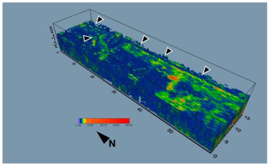
Figure 8.
Voxler visualisation of the clavicula gate at Alto da Raia. Arrows point to the location of the fortification and the clavicula.
The rampart’s core and the ditch are still visible at 80–100 cm below surface level. In addition to these two structural elements, we could identify a line running parallel to the rampart’s core underneath the previously defined ditch at a depth of ca. 120 cm. The reflection amplitude suggests that this could be the compacted bottom of the trench. Even lower levels do pinpoint this feature. At lower depths, the feature is surrounded by heterogeneous reflections, most possibly belonging to the decomposition of the bedrock. Therefore, we conclude that archaeological layers are located only 1.5 m below the ground level.
The positive results obtained at Alto da Raia are due to the overall good preservation of the camp’s structures. The absence of modern cultivation with mechanised ploughing in this area permitted these structures to survive. The rocky slate and granitic environment described above affect the quality of the obtained GPR images since the decomposition of the rock introduces considerable noise to the depth slices. This is especially noticeable when compared with other study cases where fine grain sediments prevail, i.e., Villa María or Andinales (see Section 3.3). Nevertheless, the results were generally positive and allowed a new interpretation of the camp.
3.2. Sueros de Cepeda
The geomagnetic survey on the western sector of this camp revealed a shallow line that essentially fits with the defensive ditch outline proposed after different aerial coverages were interpreted [7]. The objective of the GPR survey was to extract volumetric data about this feature before its excavation.
A linear feature measuring 40 m long and showing a variable width is visible almost below the ploughing surface (0 to 30 cm), disappearing beyond 110–120 cm deep (Figure 9). At this point, a solid linear amplitude may reflect the very bottom of the ditch. The direction of GPR lines could have caused difficulties in defining the width of this feature. Moreover, the spacing between the survey lines (50 cm) also has an impact on the visualisation of structures. Even if the overall resolution is acceptable, decreasing the spacing also helps define the structures in a more detailed way. The survey was performed following the plough lines to avoid bumps and the loss of coupling between the GPR antenna and the ground. Although this was a reasonable decision in logistical terms, the limited results persuaded us to approach these archaeological features perpendicularly in the future, generating profiles by ‘cutting’ the trenches. Nevertheless, in other study cases, such as Sasamón, the alignment of archaeological features and survey lines did allow the adequate recording of the former. The overall size of the structures, differential soil, backfill material’s characteristics, and contrast with the surrounding soil matrix could explain this phenomenon.
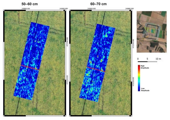
Figure 9.
Selected depth slices of the western defensive line at the Roman camp of Sueros de Cepeda. The black line shows the location of the defensive ditch according to the crop marks detected on the aerial imagery. Red line indicates the location of excavation. EPSG: 25830.
No other archaeological features were detected within the survey area, meaning that recent agrarian works completely erased earth ramparts to the interior of the external ditch. These observations could be considered paradigmatical of the temporary camps in the plains of the Duero valley, where constant ploughing has eroded any topographical expression of ancient ephemeral structures. Archaeological excavations later confirmed GPR interpretations, which allowed us to characterise the traces of the site’s defences (see Section 4). A V-shaped ditch was identified after removing 30 cm of agricultural soil. It was filled with distinctive, slightly darker deposits from the natural colluvial layers with more abundant rolling stones. Indeed, GPR prospection was useful to identify the precise location of the external ditch, assess the dimensions of the structure with accuracy, both wide and deep (Figure 10), and ultimately predict the labour effort needed to investigate these ephemeral traces of the Roman army at Sueros de Cepeda.
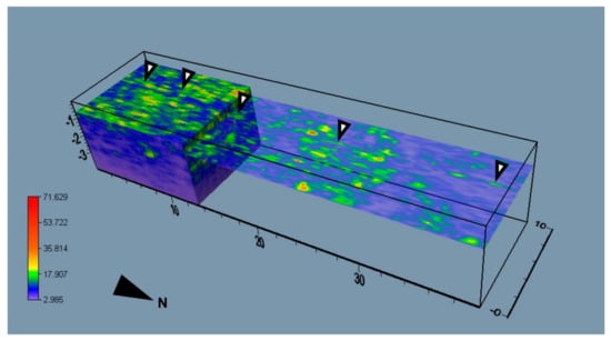
Figure 10.
Voxler visualisation of the GPR survey at Sueros de Cepeda. Arrows point to the camp’s defensive ditch.
3.3. Siege of Cerro de Castarreño
Since the magnetometer did not give good results in the Villa María sector, the GPR survey was vital in defining the archaeological structures here located. This situation resembled our first geophysical survey in Carrecastro in 2017, where magnetometry could not document the perimeter defences of the camp [31].
In Villa María, the defensive ditches are visible in the GPR data at a shallow depth (ca. 50–60 cm below the ground level) (Figure 11). The surrounding ground matrix, excavated in the hard limestone rock, contrasts with the backfilled ditches. Therefore, the latter is visible until ca. 190 cm below the ground level. This sedimentation process is supposed to have taken place quickly after the defeat of the inhabitants of the Late Iron Age oppidum of Cerro de Castarreño.
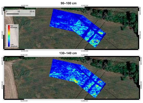
Figure 11.
Selection of depth slices at Villa María, with the indication of the interpreted lines of the siege system. Red lines mark the location of the excavation. EPSG: 25830.
One of the most exciting results of the GPR survey was discovering a ditch section that was not visible in aerial photography. Initially, we thought that the small military camp in the area of Villa María was attached to the inner structures of the contravallatio, using these defensive lines to protect its north-western flank. Nevertheless, the camp defences continue towards the northwest, intersecting the double ditch. The morphology of the two structures is very similar, and both were detected at similar depths, so we cannot determine which one was built first at this stage. The synchronicity of the two elements seems unlikely (Figure 11 and Figure 12). One possible explanation for this phenomenon is that the camp was built before the siege lines and that the latter reduced the size of the former during a second phase. Although possible, the option of an extension of the camp seems unlikely. The second hypothesis is that the siege lines were erased and backfilled in a second phase corresponding to the construction or enlargement of the camp. In this case, we should be able to appreciate differences in the deposits clogging the different sections of the ditches in future excavations.
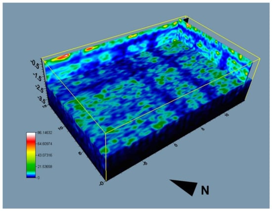
Figure 12.
Voxler visualisation using Face Render of the double ditch system and the camp’s ditch at Villa María.
Results were also good in the Los Andinales sector (Figure 13 and Figure 14). Once again, we initially assumed that the siege lines would connect with the camp ditch. The upper section of the ditches starts to be visible at 50 cm below the ploughed horizon, and these are detectable until ca. 120 cm deep. Interestingly, the GPR slices show a 10 m long gap between the two elements under analysis. In theory, the interruption may not make any defensive sense, but it could be related to the presence of a gate. Given the enormous effort to build the siege complex, it seems unlikely that the Romans considered soil hardness a limiting factor.
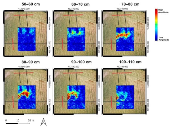
Figure 13.
Selection of depth slices at Los Andinales camp. Note the double ditch and the black lines resulting from the interpretation of the siege scenario in aerial photography. Red lines mark the location of excavation trenches. EPSG: 25830.
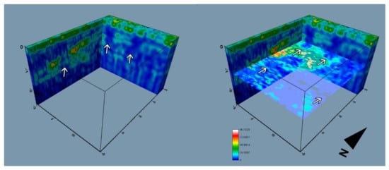
Figure 14.
Voxler visualisation of the double ditch and the camp trench. Arrows point to the low amplitude values that indicate ditches.
The visualisation of the volumetric data (Figure 14) also provides good information to detect the different characteristics of the trench fillings. The volumetric visualisation cannot provide accurate information about the trench profiles, but the excavation shows characteristic V-shaped solutions [17] (see the location of the trench in Figure 13, and excavation in Figure 15d. In this study case, the survey aimed to spot features that, in some cases, appear parallel to the path followed by the GPR sensor, which is an obstacle to achieving the highest data quality. The survey was arranged to cross perpendicular to some of the lines spotted in aerial photography. However, some of the trenches could not be surveyed in the same way. Nevertheless, the differential properties of the backfills can be easily individualised to calculate depth and volume.
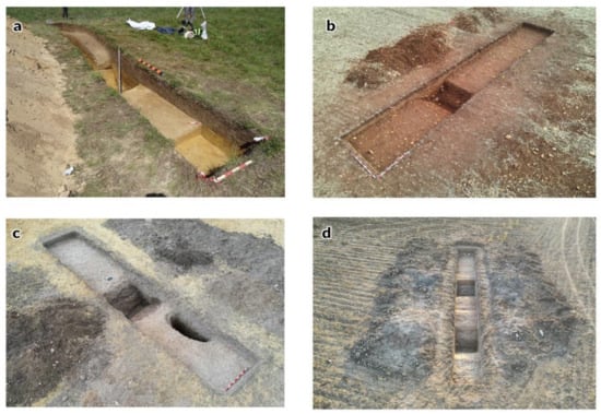
Figure 15.
(a) Excavation at Alto da Raia (photography courtesy of Era-Arqueologia); (b) Excavation trench at Sueros de Cepeda (photography: DGA); (c) Excavation trench at Villa María (photography JMCG); (d) Excavation trench at Los Andinales (photography JMCG).
4. Discussion
The lucky coincidence of several Roman camps being excavated simultaneously during 2021 in different areas of north-western Iberia allowed us to carry out an experimental, small-scale GPR survey to assess their potential outcomes. The overall results of GPR survey on ephemeral Roman army traces were deemed positive since the dug-out defensive structures were easily sensed in all of them. The geophysical survey in Alto da Raia allowed us to map a previously unknown built feature. This canonical clavicula gate will be subject to further investigation in future archaeological works.
However, this approach works best in combination with other techniques. The methodology for studying all the sites presented above comprised remote sensing techniques (LiDAR, aerial/satellite imagery, and UAV mapping), geophysical surveys (magnetometry and GPR), and archaeological excavation and sampling (Figure 15). The research carried out in Alto da Raia, Sueros de Cepeda, and the siege of Cerro de Castarreño benefited from a coordinated strategy in which geophysical prospection and excavation were carried out under the same premises. This initiative laid its foundations in the experience acquired after a decade of archaeological projects exploring different methodologies for studying archaeological features in north-western Iberia [4,49].
From a technical point of view, this experimental approach allows us to conclude that it is possible to gather valuable data for identifying ephemeral features related to short-term Roman military occupations in the different environments within the study area. In applying GPR surveys, traditional interpretation based on primary products such as slice layers and radargrams could be complemented by the volumetric visualisation of low-amplitude signals. More refined processing methods such as Hilbert transformation should be explored to isolate subtle changes in soil composition. Once again, recent methodological developments reveal how traditional pessimism regarding identifying the ancient traces of the Roman military deployment in north-western Iberia has been definitively overcome. This methodological leap forward is causing a profound transformation in the archaeological debates devoted to the Roman expansion in the region, overcoming traditional pessimism [50,51] about the possibility of identifying material traces related to Roman military activities of temporary nature. More importantly, the results of this paper support the potential of new non-invasive methodologies to produce new interpretations of the Roman–indigenous conflict beyond the textual evidence provided by the ancient Greek and Latin authors.
Optimism does not prevent us from being aware of the diverse techniques’ limitations. The resolution of the GPR data did not allow us to obtain exact information about the features’ geometry, a relevant feature to assess Roman army strategy and the techniques employed in the construction of camps and siege. That information was later achieved through archaeological excavation. This lack of precise geometric information from the Roman trenches might be related to the GPR data acquisition process: the survey sometimes aligned with the trenches due to present-day ground conditions, i.e., crops and plough lines. Nevertheless, even aligned GPR passes could map the horizontal shape of these infills in a very clear way.
The case studies’ diverse geologic and lithologic contexts do not seem to have influenced the data quality. The clayish and sandy soils produce good results with a clear contrast between the soil matrix and trenches, as seen in Villa María and Los Andinales. In Alto da Raia, the slate and granitic geology also offer a favourable scenario for the GPR survey. In this case, geology has influenced the area’s economic orientation, preventing mechanised cereal agriculture. The extensive pastoralist exploitation has preserved the archaeological features we can still detect via GPR survey.
Volumetric visualisation of the data was vital for inspecting the GPR data. This visualisation technique helps isolate backfills from soil matrices or other built structures. In cases such as Sueros de Cepeda, the ground conditions were challenging due to local geology and the intensive agricultural land use during the last decades. The combination of natural phenomena (rocky environments, floodings, etc.), summed to anthropical modification of the landscape, creates great difficulties for proper data processing and visualisation. In the last years, intensive irrigation has led to the flattening of the fields where the camp of Sueros de Cepeda is located. Where soil depletion has severely affected the original topography, the detection of the ephemeral Roman camps is even more difficult. Only in those areas where negative structures such as trenches were deep enough to survive the destruction of the upper soil deposits are visible using geophysical techniques. In addition to these problems, the geological background and underground water streams were also affected by intensive agricultural modifications.
Even if we must face these difficulties when applying magnetometry and GPR to document ephemeral and fragile archaeological features, the proposed visualisations contributed to an overall understanding of these structures. The combination of horizontal slices and other remote sensing data might increase the information about these camps and foster new excavations on these and other camps.
5. Conclusions
As stated in the introduction of this paper, the overwhelming availability of geospatial datasets, summed to the convergence of the Iberian practitioners of aerial archaeology and European scholarship, crystallised in the publication of a large amount of evidence related to the conquest of the northern regions of the Iberian Peninsula. As a result, several archaeological projects were conducted at different sites to assess their chronology, function, stratigraphy, and building techniques. As shown in this paper, GPR survey has become a fruitful method to initially evaluate the depth and location of ephemeral features related to Roman military structures, aiming to characterise those traces without affecting their preservation. In addition, it allows us to drive and maximise the results of further excavations. Within this approach, we stress the use capabilities of volumetric data for visualisation and analytical purposes. We also advocate the combination of GPR survey with other geophysical survey methods [50] and the role of excavation as a means to ground-truth features and structures and obtain samples for absolute dating and paleo-environmental studies, as well as the clarification of construction techniques.
Author Contributions
Conceptualisation: J.G.S.; Methodology: J.G.S.; Software: J.G.S.; Fieldwork: J.M.C.-G., J.F., D.G.-Á., J.G.S.; Writing–original draft preparation: J.G.S.; Writing–review and editing: J.M.C.-G., J.F., D.G.-Á., J.G.S. Project administration and fund acquisition: J.M.C.-G., J.F., D.G.-Á., J.G.S. All authors have read and agreed to the published version of the manuscript.
Funding
The Alto da Raia archaeological survey in 2021 was funded by the Montalegre and Calvos de Randín municipalities and done in collaboration with Era-Arqueologia (PIPA 201633). The survey in Sasamón and Villasandino has been funded by the Junta de Castilla y León (Contract 2021/00352/001) and Diputación de Burgos (Bopbur 5 de Agosto de 2021, P0937500G), together with the municipalities of Sasamón and Villasandino. Archaeological works at the Sueros de Cepeda camp were developed thanks to a contract established between the Villamejil City Council and the INCIPIT-CSIC (221294 CSIC ID contract, under the supervision of DGA). JGS is a postdoctoral researcher from the Instituto de Arqueología, Mérida-Junta de Extremadura, whose work is produced within an Atracción del Talento postdoctoral contract (Ref. TA18060). JMCG research was facilitated by a postdoctoral research contract funded by the Galician Autonomous Government in 2019 (Ref. ED481D 2019/006). JF research was funded by the European Commission through a Marie Skłodowska-Curie grant (agreement ID 794048). Part of JF research was also funded by FEDER through the COMPETE 2020 Programme, Lisboa Regional Programme and European Regional Development Fund (FEEI), and National Funds through FCT (Fundação para a Ciência e Tecnologia) under the scope of the Iberian Tin project (PTDC/HAR-ARQ/32290/2017). DGA research was facilitated by a 2019 Juan de la Cierva-Incorporación postdoctoral contract (Ref. IJC2019-040603-I) funded by the Spanish Ministry of Science and Innovation (MCIN/AEI/10.13039/501100011033).
Acknowledgments
We would like to thank the archaeologists who participated in the fieldwork on all three projects during summer–autumn 2021. We would also like to thank Rebeca Blanco-Rotea for sharing her discoveries on the Spanish–Portuguese border. Victor Vicente-García and Andrés Menéndez-Blanco deserve special recognition for their thorough analysis of PNOA-LiDAR, satellite, and aerial imagery in 2020. We also thank María del Carmen Muñóz from the University of Extremadura for their guidance with the volumetric representation of GPR data. We thank the CSIC Interdisciplinary Thematic Platform (PTI) Teledetección. (PTI-TELEDETECT) for encouraging collaboration between geospatial sciences and archaeology.
Conflicts of Interest
The authors declare no conflict of interest. The funders had no role in the study’s design, in the collection, analyses, or interpretation of data, in the writing of the manuscript, or in the decision to publish the results.
References
- Cerrillo Cuenca, E.; López López, A. Evaluación y Perspectivas Del Uso Del LiDAR En La Arqueología Española. Boletín Mus. Arqueol. Nac. 2020, 39, 219–236. [Google Scholar]
- Costa-García, J.M.; Fonte, J.; Gago, M. The Reassessment of the Roman Military Presence in Galicia and Northern Portugal through Digital Tools: Archaeological Diversity and Historical Problems. Mediterr. Archaeol. Archaeom. 2019, 19, 17–49. [Google Scholar]
- Peralta Labrador, E.; Camino Mayor, J.; Torres-Martínez, J.F. Recent Research on the Cantabrian Wars: The Archaeological Reconstruction of a Mountain War. J. Rom. Archaeol. 2019, 32, 421–438. [Google Scholar] [CrossRef]
- Costa-García, J.M.; González-Álvarez, D.; Gago Mariño, M.; Fonte, J.; García Sánchez, J.; Blanco-Rotea, R.; Álvarez Martínez, V. Una Década de Investigación Del Colectivo RomanArmy.Eu: Novedades y Desafíos Sobre La Conquista Romana Del Noroeste Ibérico. In Actualidad de la Investigación Arqueológica en España III (2020–2021). Conferencias Impartidas en el Museo Arqueológico Nacional; Museo Arqueológico Nacional: Madrid, Spain, 2021; pp. 153–170. [Google Scholar]
- Morillo, Á.; Currás, B.X.; Orejas, A.; Nobilini, A. El conjunto de campamentos romanos para prácticas de Trobajo del Camino (San Andrés de Rabanedo) y Oteruelo de la Valdoncina (León). Una aproximación preliminar. Gladius 2021, 41, 91–119. [Google Scholar] [CrossRef]
- Vicente García, V. Los Campamentos de Campaña en el Bellum Cantabricum: Catálogo y Estado de la Cuestión. Master’s Thesis, Universidad de Cantabria, Santander, Spain, 2019. [Google Scholar]
- Menéndez Blanco, A.; García Sánchez, J.; Costa-García, J.M.; Fonte, J.; González-Álvarez, D.; Vicente García, V. Following the Roman Army between the Southern Foothills of the Cantabrian Mountains and the Northern Plains of Castile and León (North of Spain): Archaeological Applications of Remote Sensing and Geospatial Tools. Geosciences 2020, 10, 485. [Google Scholar] [CrossRef]
- Luo, L.; Wang, X.; Guo, H.; Lasaponara, R.; Shi, P.; Bachagha, N.; Li, L.; Yao, Y.; Masini, N.; Chen, F.; et al. Google Earth as a Powerful Tool for Archaeological and Cultural Heritage Applications: A Review. Remote Sens. 2018, 10, 1558. [Google Scholar] [CrossRef]
- López Murcia, C. Use of Automated Learning Techniques for the Search of Roman Camp Remains in Georeferenced Images; Universidad de Cantabria: Santander, Spain, 2022. [Google Scholar]
- Orengo, H.A.; Conesa, F.C.; Garcia-Molsosa, A.; Lobo, A.; Green, A.S.; Madella, M.; Petrie, C.A. Automated Detection of Archaeological Mounds Using Machine-Learning Classification of Multisensor and Multitemporal Satellite Data. Proc. Natl. Acad. Sci. USA 2020, 117, 18240–18250. [Google Scholar] [CrossRef]
- Reddé, M. Les camps militaires républicains et augustéens: Paradigmes et réalités archéologiques. Salduie 2008, 8, 61–71. [Google Scholar] [CrossRef]
- Peralta Labrador, E. Los campamentos romanos de campaña (castra aestiva): Evidencias científicas y carencias académicas. Niv. Cero: Rev. Del Grupo Arqueol. Attica 2002, 10, 49–87. [Google Scholar]
- Puente, I.; Solla, M.; Lagüela, S.; Sanjurjo-Pinto, J. Reconstructing the Roman Site “Aquis Querquennis” (Bande, Spain) from GPR, T-LiDAR and IRT Data Fusion. Remote Sens. 2018, 10, 379. [Google Scholar] [CrossRef]
- Menéndez Blanco, A.; González Álvarez, D.; Álvarez Martínez, V.; Jiménez Chaparro, J.I. Propuestas de Prospección de Bajo Coste Para La Detección de Campamentos Romanos de Campaña. El Área Occidental de La Cordillera Cantábrica Como Caso de Estudio. Munibe Antropol. Arkeol. 2013, 64, 175–197. [Google Scholar]
- González Álvarez, D.; Costa-García, J.M.; Menéndez Blanco, A.; Fonte, J.; Álvarez Martínez, V.; Blanco-Rotea, R.; Gago Mariño, M. La Presencia Militar Romana En El Noroeste Ibérico Hacia El Cambio de Era: Estado Actual y Retos de Futuro. In Accampamenti, Guarnigioni e Assedi Durante la Seconda Guerra Punica e la Conquista Romana (secoli III-I aC): Prospettive Archeologiche; Vallori Márquez, B., Bellón Ruiz, J.P., Rueda Galán, C., Eds.; Edizioni Quasar di Severino Tognon: Roma, Italy, 2019; pp. 127–138. [Google Scholar]
- Henrich, P. 1975—Zwei neue frühkaiserzeitliche Militärlager an der unteren Lahn Ein Vorbericht. Interdiszip. Forsch. Zum Limes 2019, 10, 18–34. [Google Scholar]
- Habasque-sudour, A. Les Campes Militaires d’entrenaîment Romaine. In Lampertheim, Mundolsheim, Reichstett, Vendenheim «ZAC, Zone Commerciale Nord (ZCN)»; Raulr, E., Ed.; Archéologie Alsace: Seléstata, France, 2020; pp. 5–34. [Google Scholar]
- Lenďáková, Z.; Bábek, O.; Komoróczy, B.; Vlach, M.; Hüssen, C.-M.; Rajtár, J. Petrophysical and Geochemical Characterization of Sediments Filling V-Shaped Ditches of Roman Camps in Moravia, Czech Republic: Filling Processes and the Role of Pedogenesis. Geoarchaeology 2020, 35, 729–747. [Google Scholar] [CrossRef]
- Komoróczy, B.; Vlach, M.; Hüssen, C.-M.; Rajtár, J. 14C Dating of the Roman Military Interventions in the Middle Danube Barbarian World. Radiocarbon 2019, 61, 515–530. [Google Scholar] [CrossRef]
- Hanson, W.S.; Jones, R.E.; Jones, R.H. The Roman Military Presence at Dalswinton, Dumfriesshire: A Reassessment of the Evidence from Aerial, Geophysical and LiDAR Survey. Britannia 2019, 50, 285–320. [Google Scholar] [CrossRef]
- Laharnar, B.; Lozić, E. Ulaka and Nadleški Hrib (Slovenia). Sites of Military Conflicts from the Last Decades BC. Fundber. Aus Osterr. 2019, 56, 62–67. [Google Scholar]
- Cordero Ruiz, T.; Cerrillo Cuenca, E.; Pereira, C. Detección de Un Nuevo Campamento Romano En Las Inmediaciones de Mérida Mediante Tecnología LiDAR. Saguntum 2017, 49, 197–201. [Google Scholar] [CrossRef]
- Paniego Díaz, P. El Barrito: Un posible campamento militar romano en la Baeturia Celticorum. Onoba. Rev. Arqueol. Antigüedad 2021, 9, 223–230. [Google Scholar] [CrossRef]
- Camino Mayor, J.; Peralta Labrador, E.; Torres Martínez, J.F. Las Guerras Astur-Cántabras; KRK Ediciones: Gijón, Spain, 2015. [Google Scholar]
- Costa García, J.M.; Fonte, J. Scope and Limitations of Airborne LiDAR Technology for the Detection and Analysis of Roman Military Sites in Northwest Iberia. In Harvesting the benefits of 10 years of training in the Iberian Peninsula (2006–2015); Mayoral Herrera, V., Parcero, C., Fábrega, P., Eds.; Sidestone Press: Leiden, The Netherlands, 2017; pp. 57–73. [Google Scholar]
- Pujol, A.; Fernández-Götz, M.; Sala, R.; Padrós, C.; Ble, E.; Tamba, R.; Rubio-Campilo, X. Archaeology of the Roman Civil Wars: The Destruction of Puig Ciutat (Catalonia, Spain) and Caesar’s Campaign in Ilerda (49 BC). In Julius Caesar’s Battle for Gaul: New Archaeological Perspectives; Fitzpatrick, A.P., Haselgrove, C., Eds.; Oxbow Books: Oxford, UK, 2019; pp. 227–241. [Google Scholar]
- Pincus, J.A.; de Smet, T.S.; Tepper, Y.; Adams, M.J. Ground-Penetrating Radar and Electromagnetic Archaeogeophysical Investigations at the Roman Legionary Camp at Legio, Israel. Archaeol. Prospect. 2013, 20, 175–188. [Google Scholar] [CrossRef]
- Goodman, D.; Piro, S. GPR Remote Sensing in Archaeology; Springer: New York, NY, USA, 2013. [Google Scholar]
- Conyers, L.B. Ground-Penetrating Radar for Archaeology; AltaMira Press: Walnut Creek, CA, USA; New York, NY, USA, 2004. [Google Scholar]
- Chen, F.; Guo, H.; Tapete, D.; Cigna, F.; Piro, S.; Lasaponara, R.; Masini, N. The Role of Imaging Radar in Cultural Heritage: From Technologies to Applications. Int. J. Appl. Earth Obs. Geoinf. 2022, 112, 102907. [Google Scholar] [CrossRef]
- Fernández-Götz, M.; Costa-García, J.M.; García Sánchez, J.; Fonte, J. Aerial Archaeology at Sasamón (Burgos, Spain): Iron Age Hillfort and Roman Camps. AARGNews 2017, 55, 35. [Google Scholar]
- Pisz, M.; Mieszkowski, R.; Jeczmienowski, E. Understanding the Anomaly: Multi-Method Geoscientific Research Applied on a Roman Fort in Pojejena. In New Global Perspectives on Archaeological Prospection; Bonsall, J., Ed.; New Global Perspectives on Archaeological Prospection; Archaeopress: Oxford, UK, 2019; pp. 129–132. [Google Scholar]
- Pisz, M.; Tomas, A.; Hegyi, A. Non-Destructive Research in the Surroundings of the Roman Fort Tibiscum (Today Romania). Archaeol. Prospect. 2020, 27, 219–238. [Google Scholar] [CrossRef]
- Ariño, E.; Ezquerro, A.; García Sánchez, J.; González-Tablas, J.; Sala, R.; de Soto, R. La Ciudad de Libia (Herramelluri, España) y Su Territorio: Arqueología Del Paisaje y Prospección Intensiva. Agric. Centuriati. 2019, 16, 117–138. [Google Scholar] [CrossRef]
- García Sánchez, J.; Costa-García, J.M. Remote Sensing and Geophysical Survey in Veladiez. A New Sector of the Roman Town of Segisamo (Sasamón, Burgos). Cad. Lab. Xeolóxico Laxe 2021, 43, 41–60. [Google Scholar] [CrossRef]
- Seren, S.; Eder-Hinterleitner, A.; Neubauer, W.; Löcker, K.; Melichar, P. Extended Comparison of Different GPR Systems and Antenna Configurations at the Roman Site of Carnuntum. Near Surf. Geophys. 2007, 5, 389–394. [Google Scholar] [CrossRef]
- Manataki, M.; Sarris, A.; Donati, J.; Cuenca-García, C. GPR: Theory and Practice in Archaeological Prospection. In Best Practices of GeoInformatic Technologies for the Mapping of Archaeolandscapes; Sarris, A., Ed.; ArchaeoPress: Oxford, UK, 2015; pp. 13–24. [Google Scholar]
- Sarris, A.; Kalayci, T.; Moffat, I.; Manataki, M. An Introduction to Geophysical and Geochemical Methods in Digital Geoarchaeology. In Digital Geoarchaeology; Springer: Cham, Switzerland, 2018; pp. 215–236. ISBN 978-3-319-25314-5. [Google Scholar]
- Voxler® from Golden Software, LLC. Available online: https://www.goldensoftware.com/products/voxler (accessed on 1 April 2022).
- Zheng, L.; Liu, Z.; Wang, G.; Zhang, Z. Research on Application of Hilbert Transform in Radar Signal Simulation. In Proceedings of the 7th International Conference on Environment and Engineering Geophysics & Summit Forum of Chinese Academy of Engineering on Engineering Science and Technology, Beijing, China, 6–29 June 2016; Atlantis Press: Paris, France, 2021; pp. 347–349. [Google Scholar]
- García Sánchez, J.; Costa-García, J.M. El Oppidum Del Cerro de Castarreño, Olmillos de Sasamón. Historiografía y Arqueología de Un Hábitat Fortificado de La Segunda Edad Del Hierro. Boletín Inst. Fernán González 2019, 258, 9–45. [Google Scholar]
- Didierjean, F.; Morillo Cerdán, A.; Petit-Aupert, C. Traces de guerres, traces de paix armée: L’apport de quatre campagnes de prospection aérienne dans le nord de l’Espagne. In La Guerre et ses Traces: Conflits et Sociétés en Hispanie à L’époque de la Conquête Romaine (IIIe-Ier s. a. C.); Cadiou, F., Navarro Caballero, M., Eds.; Ausonius: Bordeaux, France, 2014; pp. 149–180. [Google Scholar]
- García Sánchez, J.; Costa-García, J.M. Del oppidum indígena a la ciudad romana. Evolución del paisaje de Segisamo (Sasamón, Burgos, España) a través de la fotografía aérea. Datos de la prospección aérea de 2019. Lucentum 2020, 39, 131–148. [Google Scholar] [CrossRef]
- García Sánchez, J. Arqueología y Paisaje en el Noroeste de Burgos: La Transición de la Segunda Edad de Hierro a Época Romana a Través del Registro Material; Universidad de Cantabria: Santander, Spain, 2012. [Google Scholar]
- Vicente García, V.; Díaz Jiménez, S. Nuevas evidencias arqueológicas en la provincia de Soria: Posibles aportaciones para el estudio de la presencia militar romana en la Submeseta Norte. BSAA Arqueol. 2021, LXXXVII, 1–29. [Google Scholar] [CrossRef]
- Martín Hernández, E.; Martínez Velasco, A.; Díaz Alonso, D.; Muñoz Villarejo, F.; Bécares Rodriguez, L. Castrametación romana en la Meseta Norte hispana: Nuevas evidencias de recintos militares en la vertiente meridional de la cordillera Cantábrica (provincias de Burgos y Palencia). Zephyrvs 2020, 86, 143–164. [Google Scholar] [CrossRef]
- Reddé, M. Recent Archaeological Research on Roman Military Engineering Works of the Gallic War. In Julius Caesar’s Battle for Gaul: New Archaeological Perspectives; Fitzpatrick, A.P., Haselgrove, C., Eds.; Oxbow Books: Oxford, UK, 2019; pp. 91–112. [Google Scholar]
- Davies, G. Roman Siege Works; Tempus: Stroud, UK, 2004. [Google Scholar]
- Fonte, J.; Costa-García, J.M.; Gago, M. O Penedo Dos Lobos: Roman Military Activity in the Uplands of the Galician Massif (Northwest Iberia). J. Confl. Archaeol. 2021, 1–25. [Google Scholar] [CrossRef]
- Morillo Cerdán, A. Los campamentos romanos de la Meseta Norte y el Noroeste: ¿un limes sin frontera?”. In Los Finisterres Atlánticos en la Antigüedad: Época Romana y Prerromana (Coloquio Internacional): Homenaje a Manuel Fernández Miranda; Fernández Ochoa, C., Ed.; Sociedad Editora Electa España; Ayuntamiento de Gijón: Madrid, Spain, 1996; pp. 77–83. [Google Scholar]
- Orejas, A.; Sánchez-Palencia, F.J. Arqueología de la conquista del noroeste de la Península Ibérica”. In II Congreso de Arqueología Peninsular, Vol. IV. Arqueología Romana y Medieval; Universidad de Alcalá: Zamora, Spain; Fundación Rei Henriques: Zamora, Spain, 1999; pp. 23–37. [Google Scholar]


Publisher’s Note: MDPI stays neutral with regard to jurisdictional claims in published maps and institutional affiliations. |
© 2022 by the authors. Licensee MDPI, Basel, Switzerland. This article is an open access article distributed under the terms and conditions of the Creative Commons Attribution (CC BY) license (https://creativecommons.org/licenses/by/4.0/).