
Identifying Potential Sites for Rainwater Harvesting Structures in Ghazi Tehsil, Khyber Pakhtunkhwa, Pakistan, Using Geospatial Approach


Abstract

1. Introduction
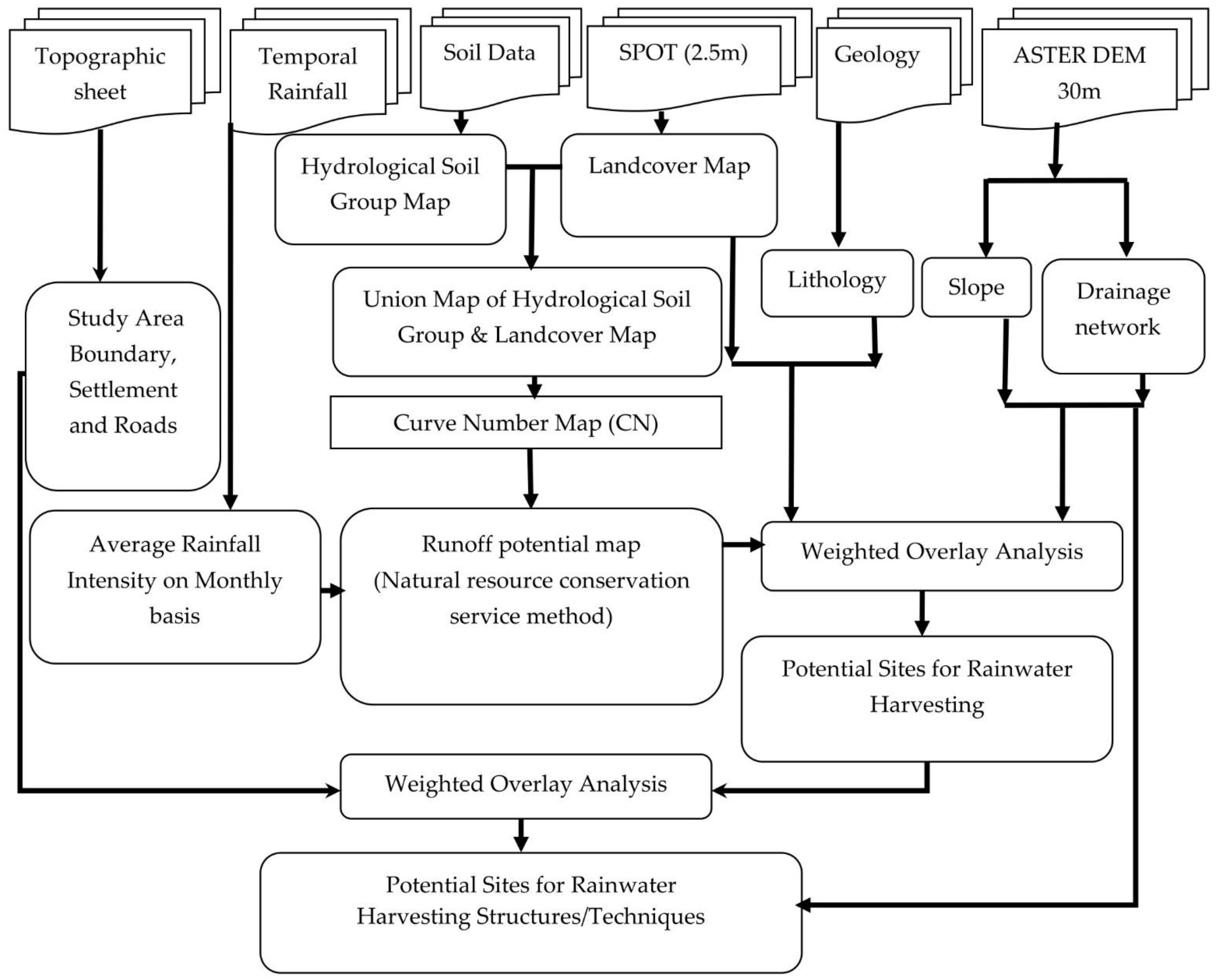
2. Materials and Methods
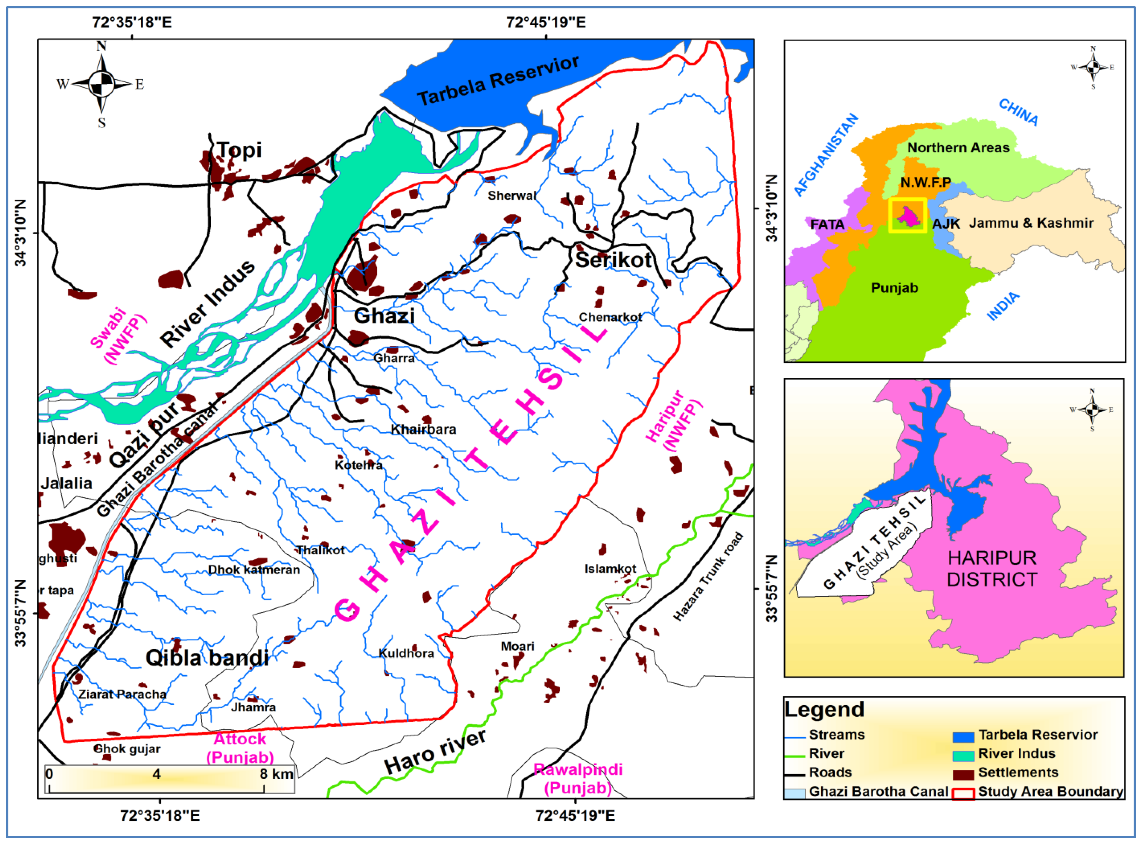
2.1. Study Area
2.2. Datasets
2.3. Data Processing
2.4. Runoff Estimation Using Soil Conservation Service Method
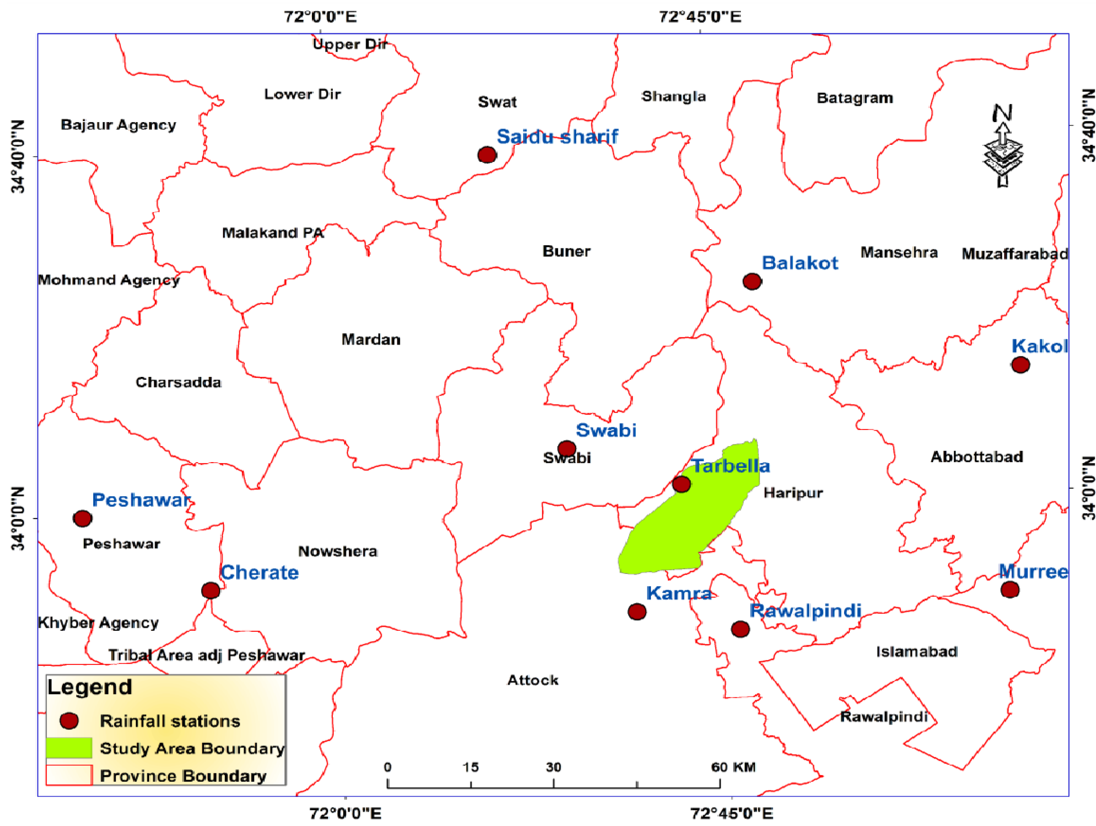
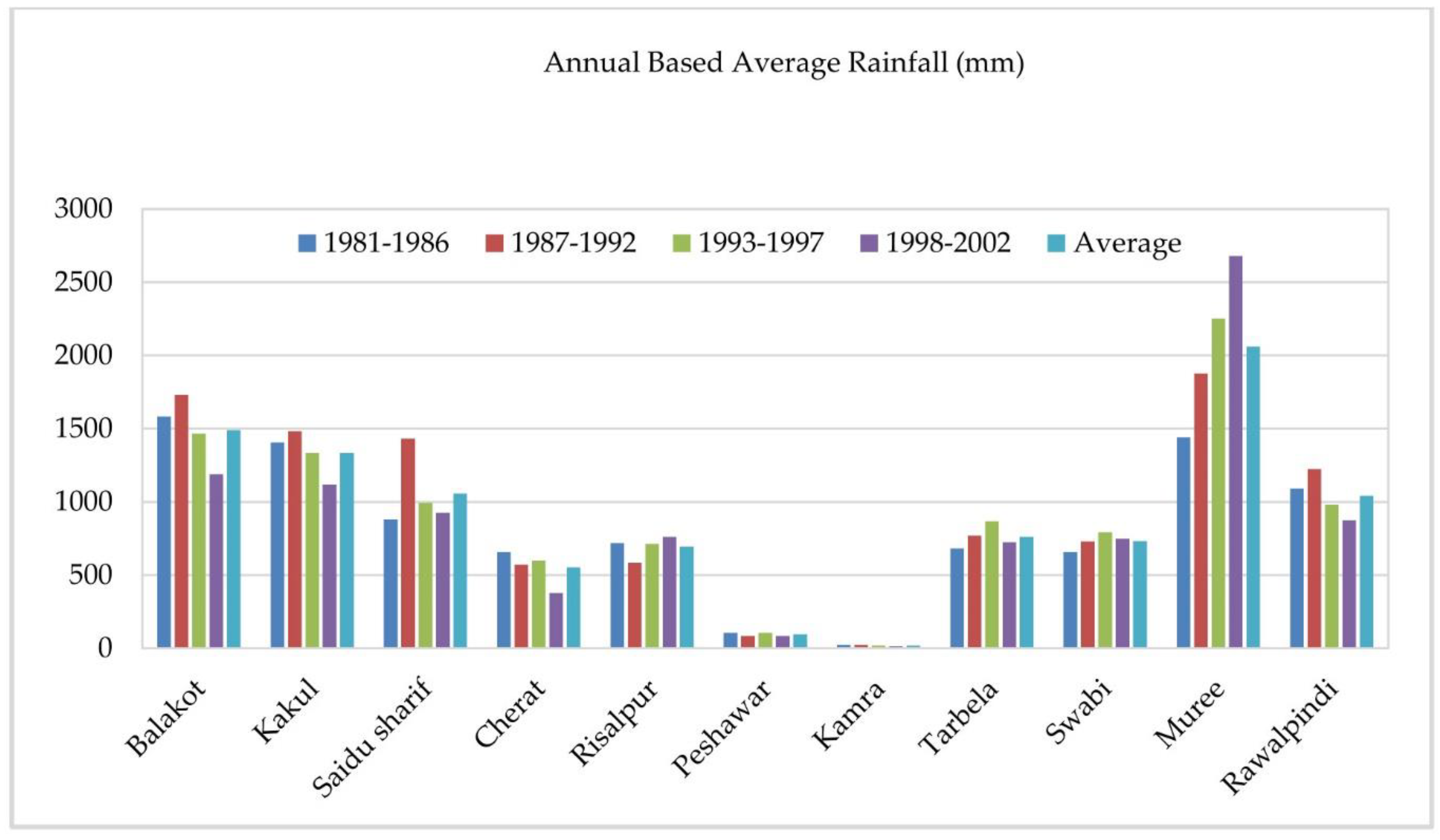
2.4.1. Rainfall Data
2.4.2. Curve Number, Grid Map Generation and Curve Number Lookup Table
2.5. Potential Sites for Rainwater Harvesting
2.5.1. Surface Slope
2.5.2. Drainage Network
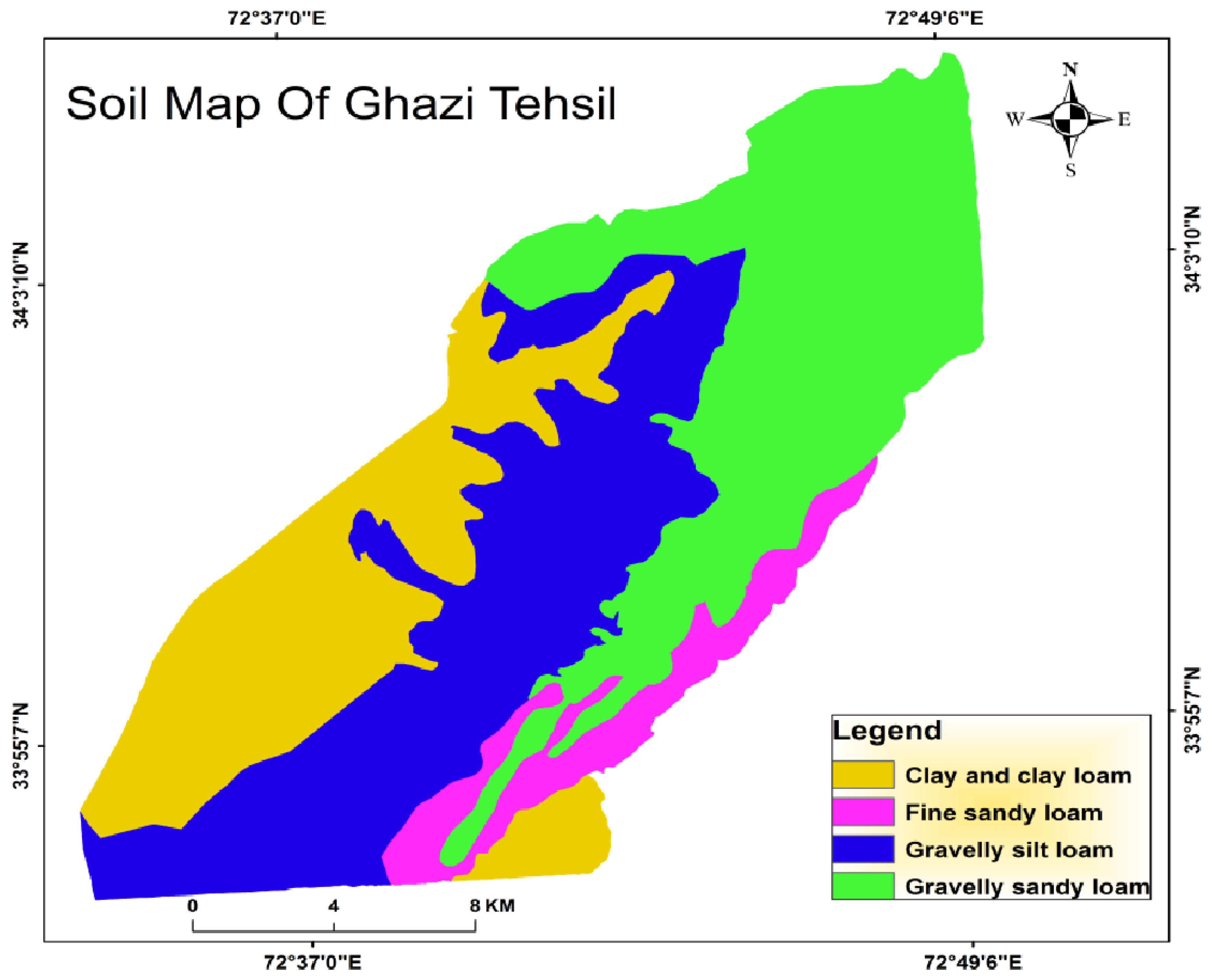
2.5.3. Soil Data
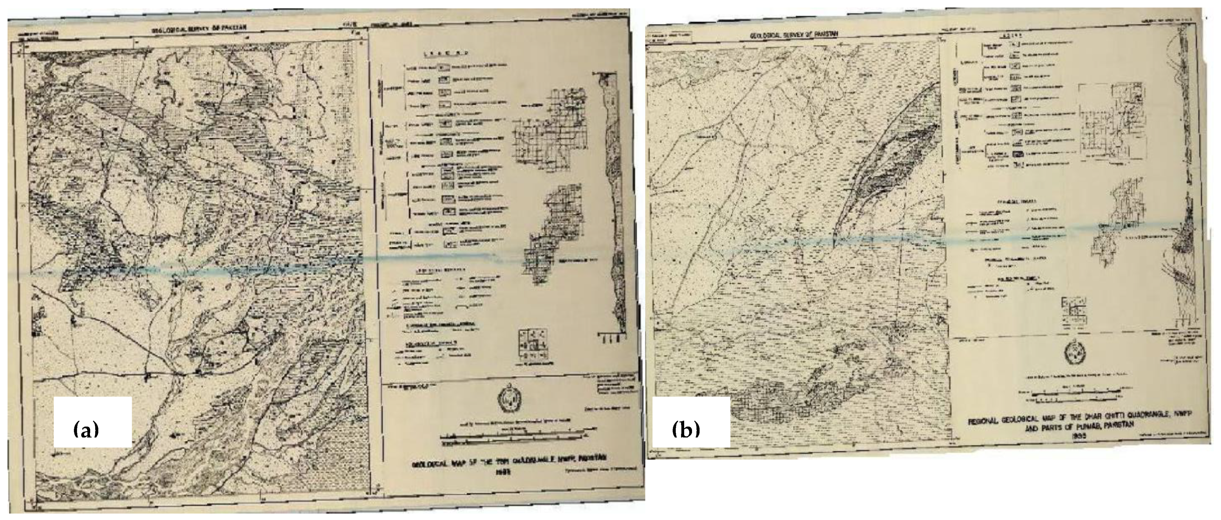
2.5.4. Geological Data
2.5.5. Landcover and Land Use Data
2.6. Rainwater Harvesting Techniques (Structures)
- Farm Ponds
- b.
- Check dams
- c.
- Nigarims
- d.
- Gully Plugs
3. Results
3.1. Runoff Estimation
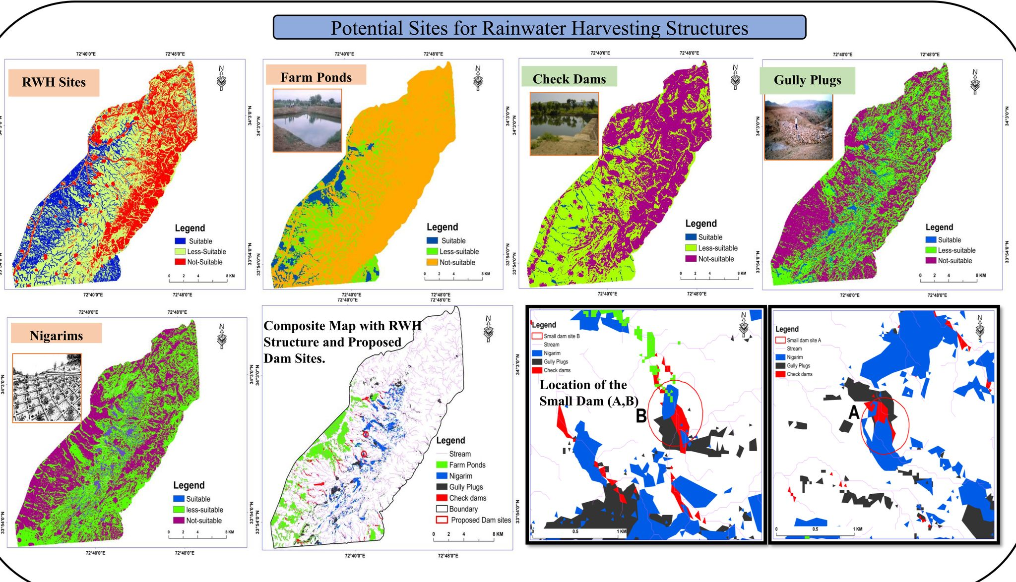
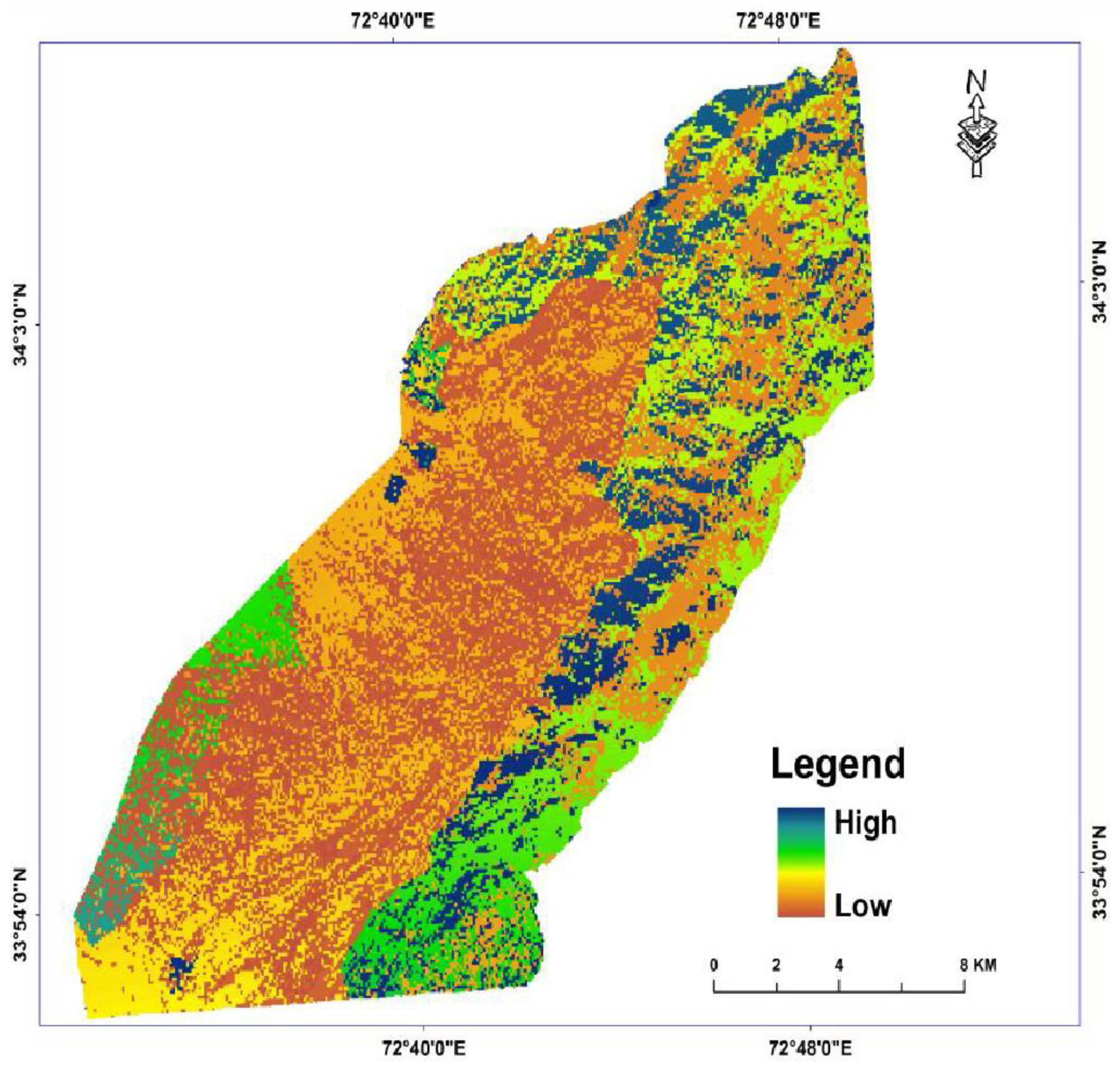
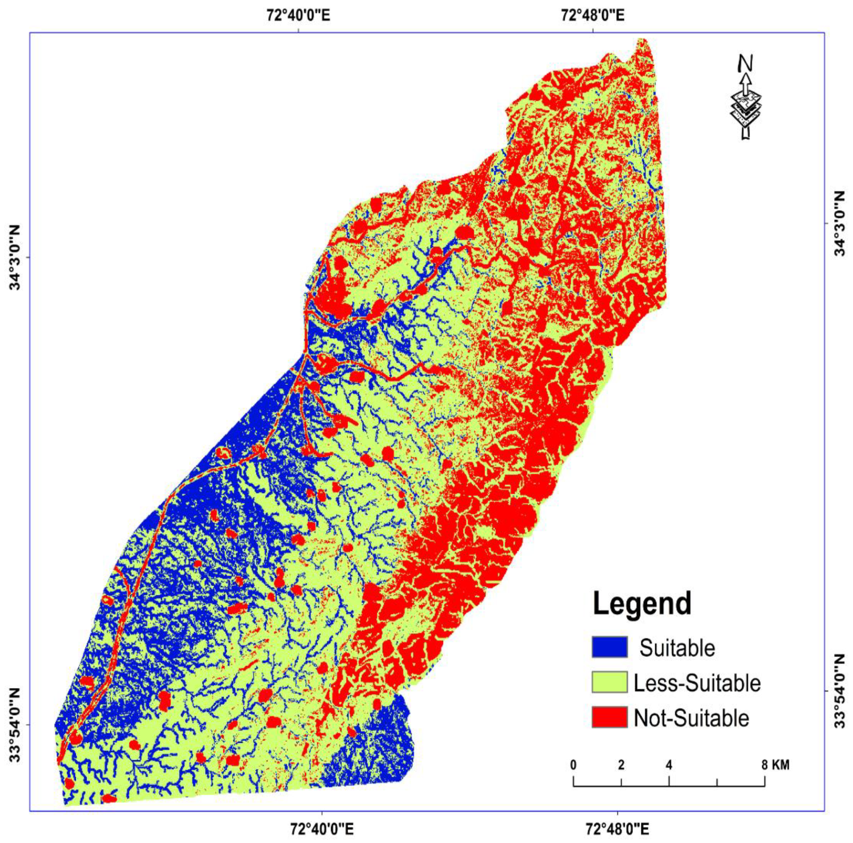
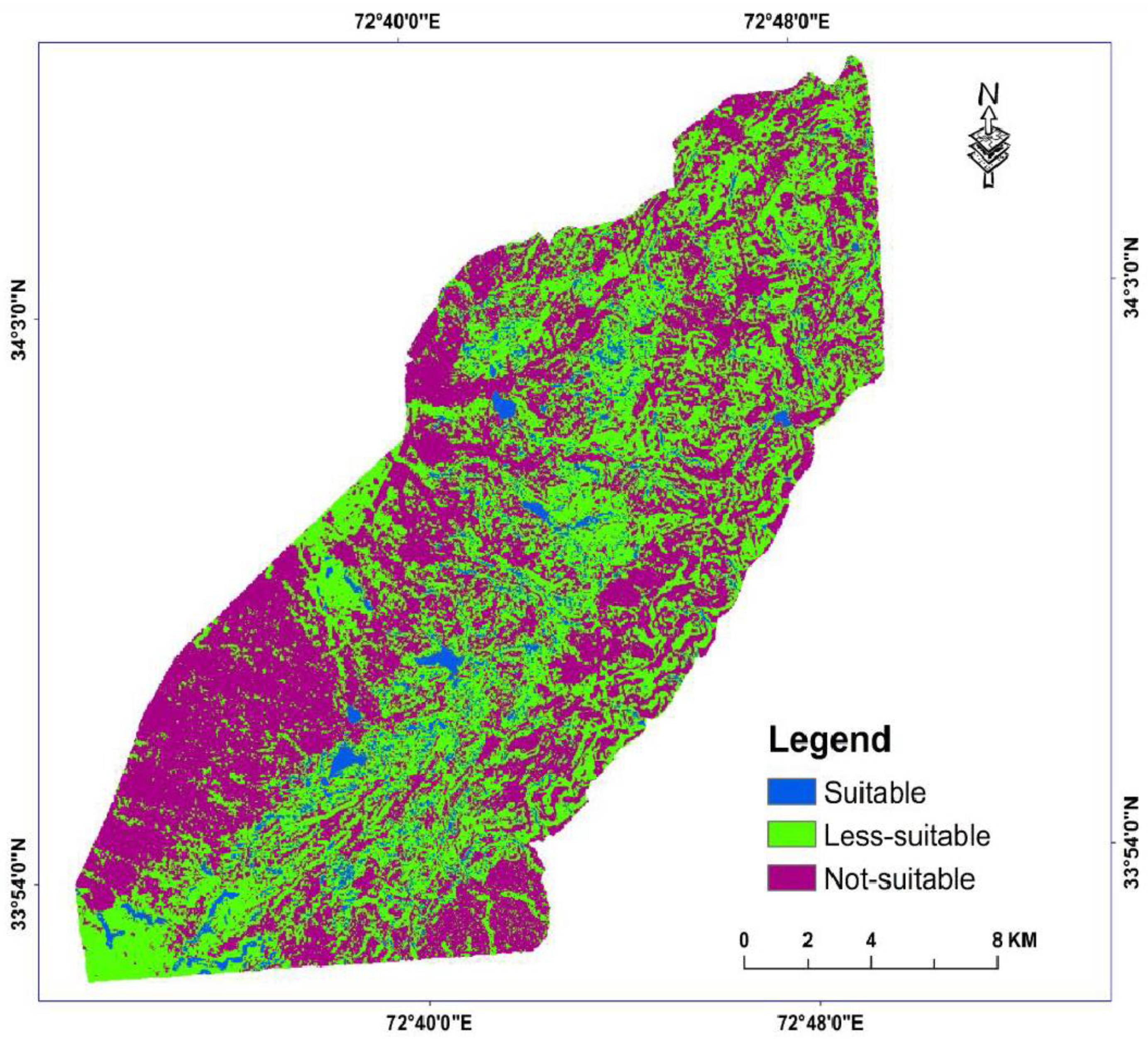
3.2. Potential Sites of Rainwater Harvesting
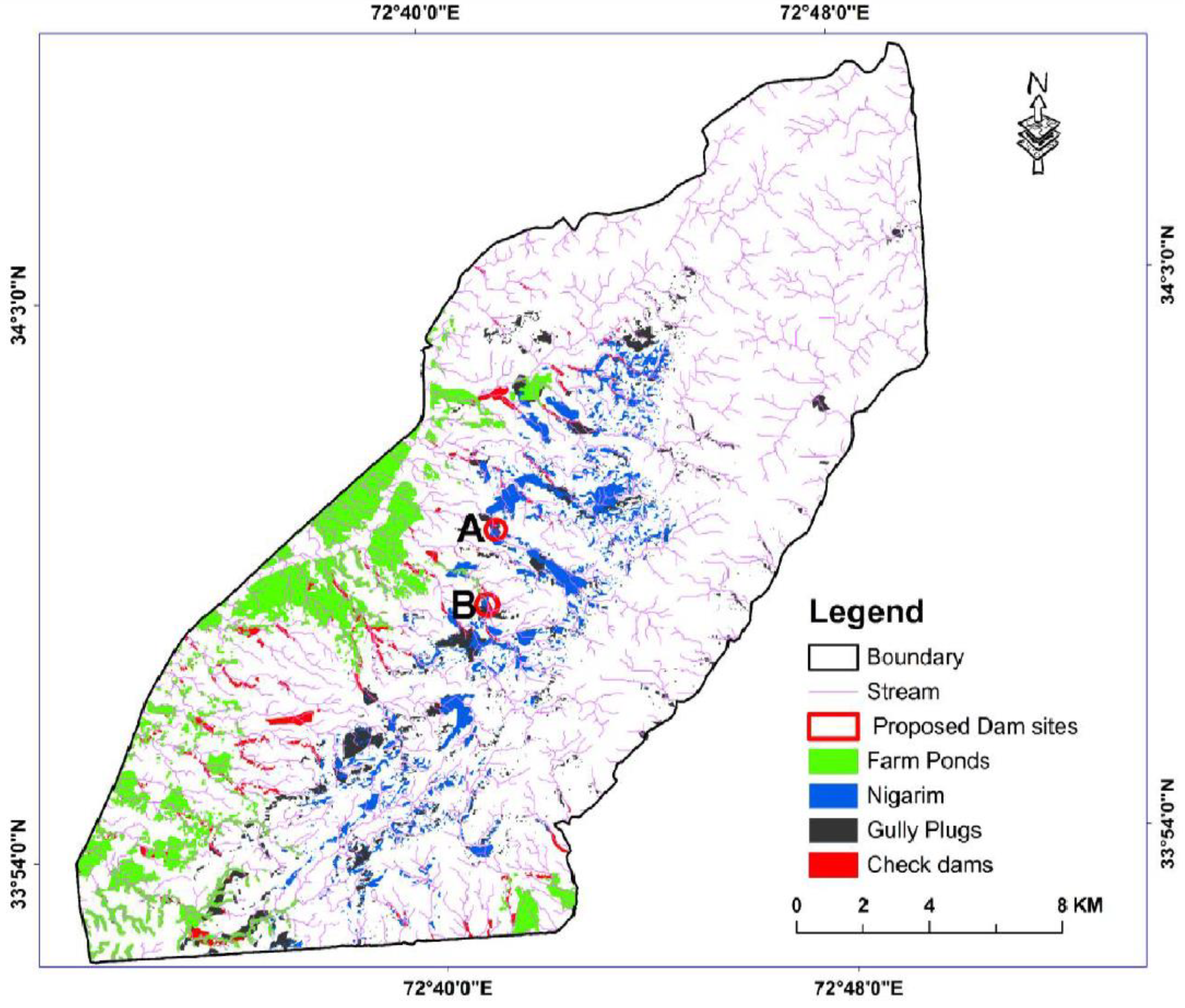
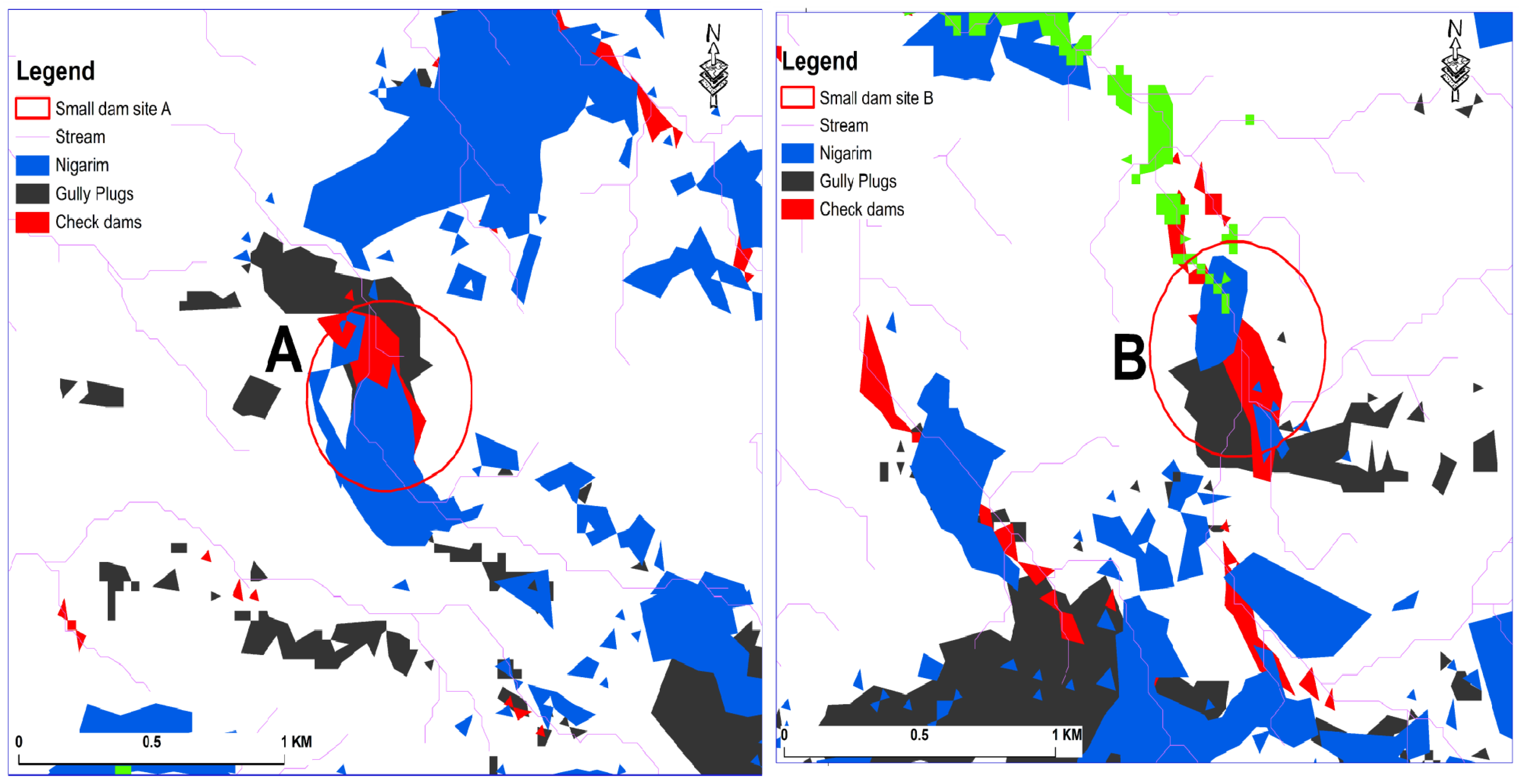
3.3. Potential Structures for Rainwater Harvesting
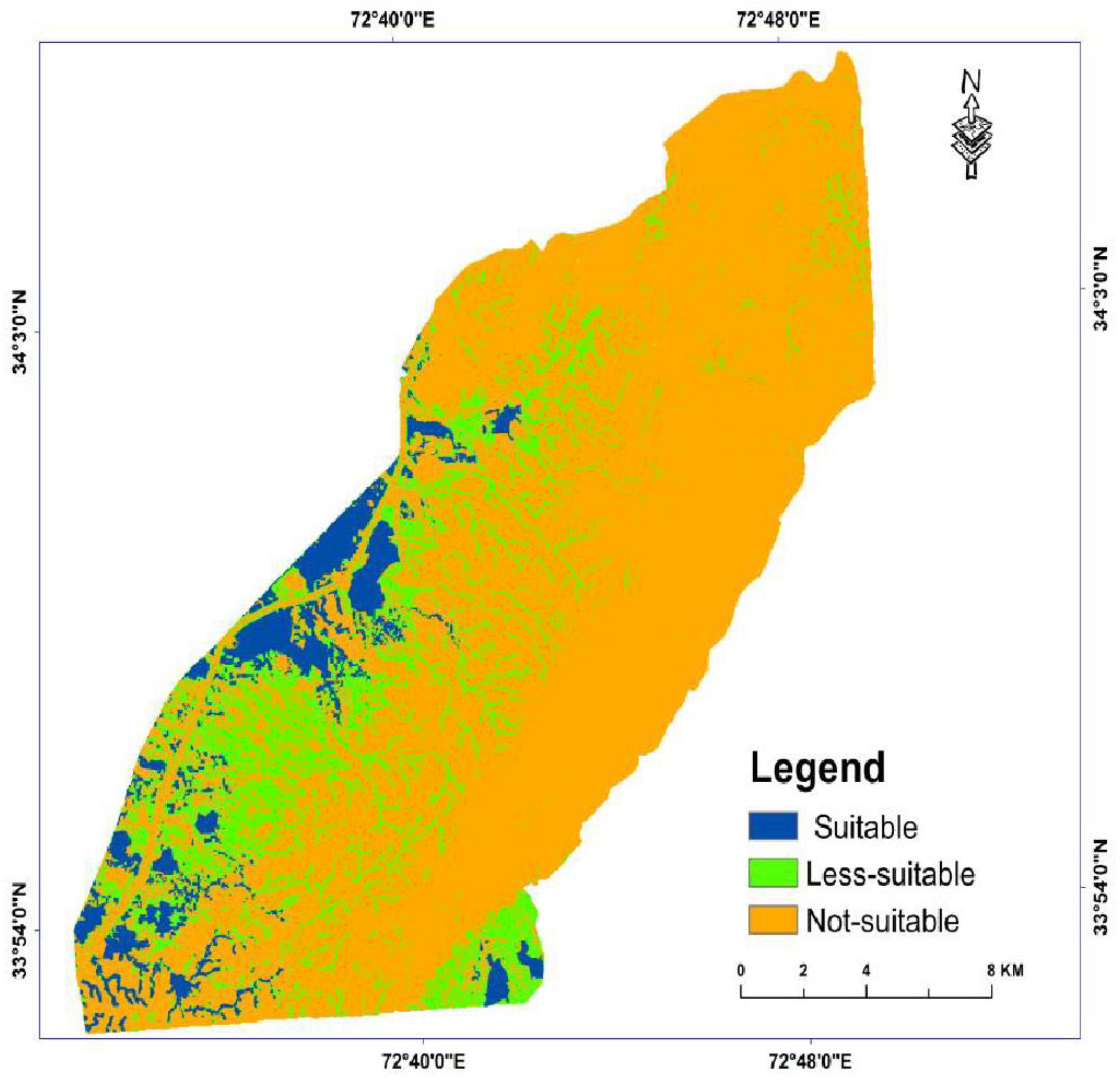
3.3.1. Farm-Ponds
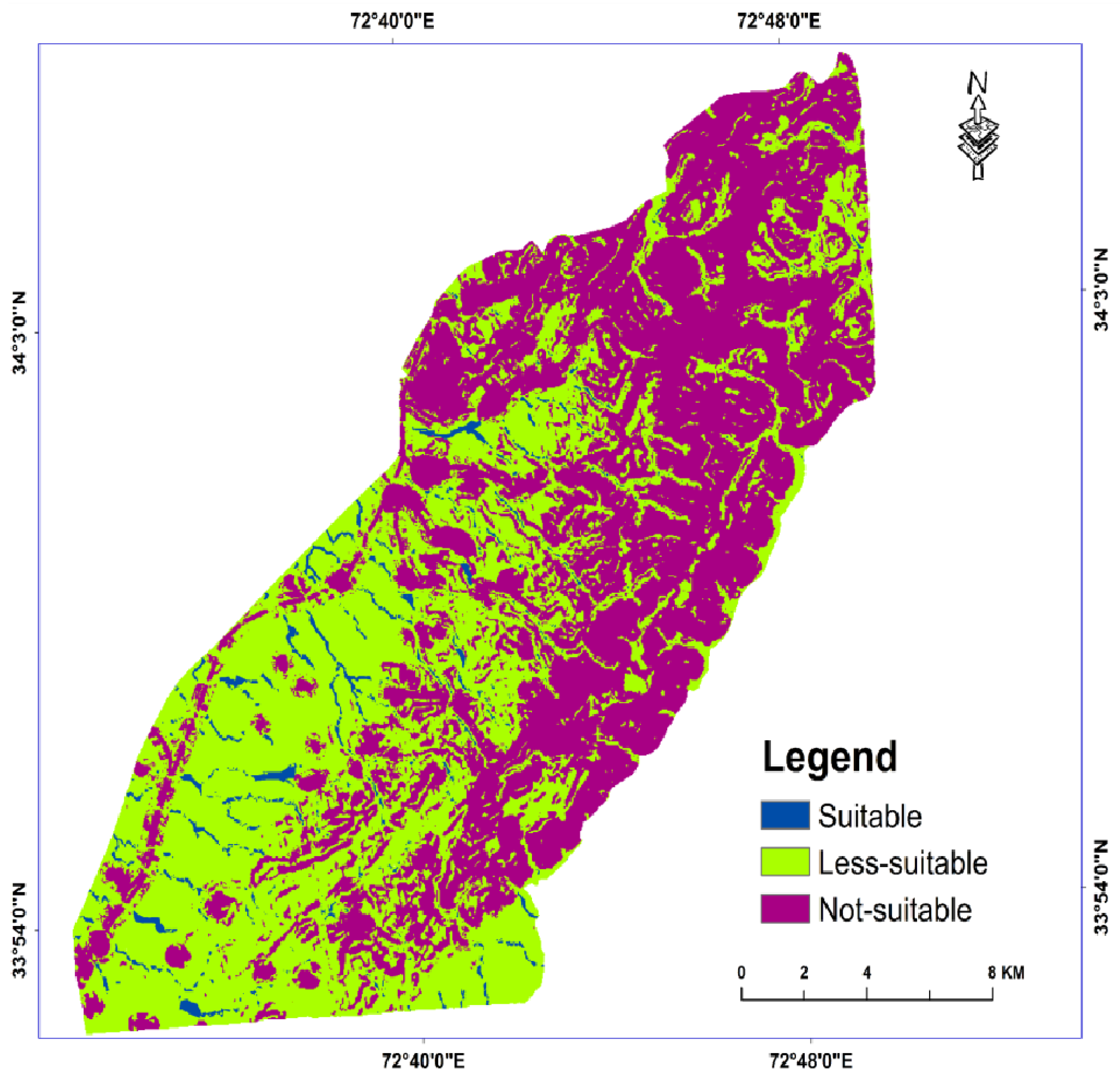
3.3.2. Check Dams
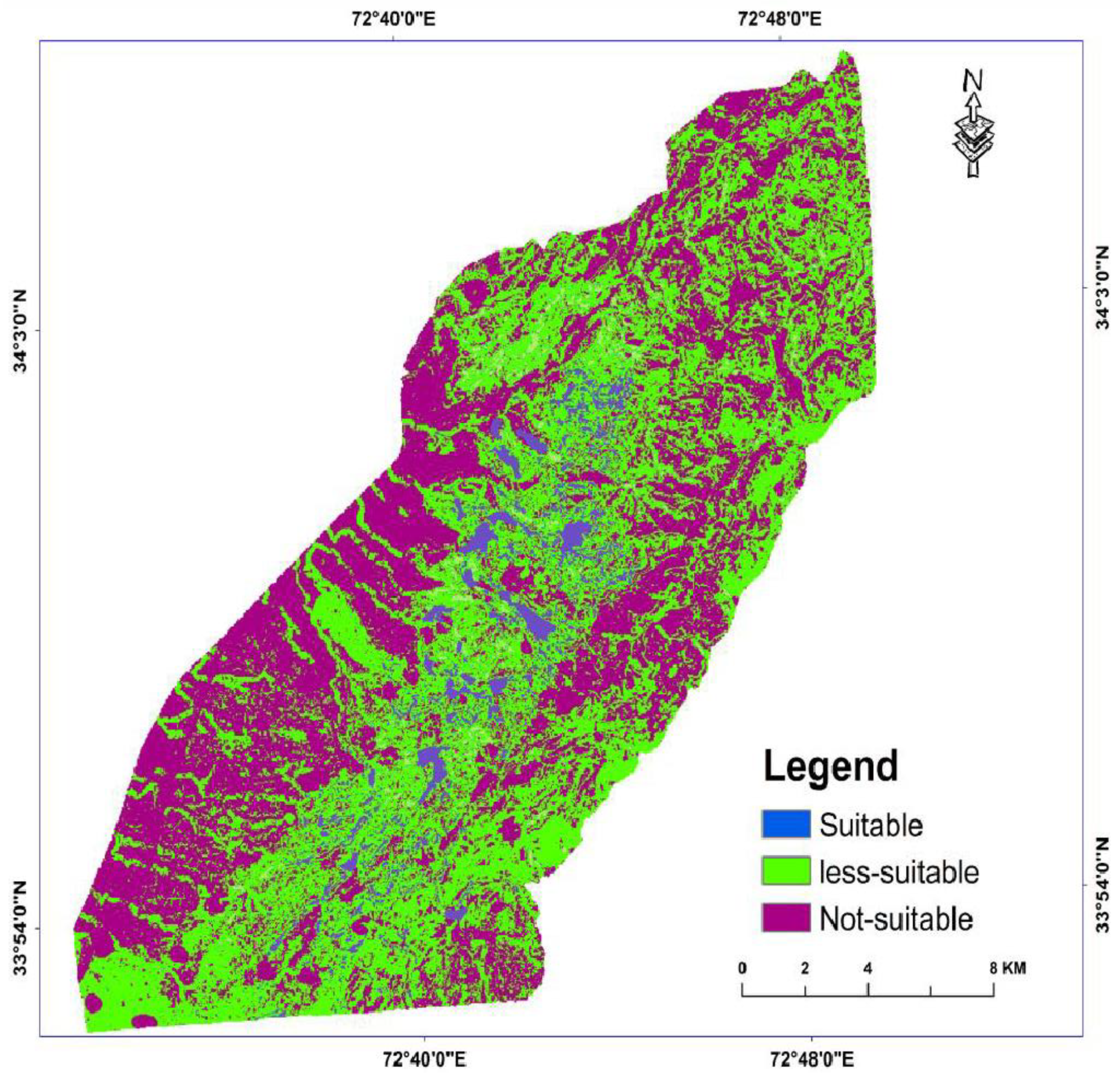
3.3.3. Nigarims
3.3.4. Gully Plugs
3.4. Composite Overlay Analysis and GIS Results with Their Correlation to Field-Based Results
4. Discussion
5. Conclusions
Author Contributions
Funding
Acknowledgments
Conflicts of Interest
References
- Zhang, S.; Jing, X.; Yue, T.; Wang, J. Performance assessment of rainwater harvesting systems: Influence of operating algorithm, length and temporal scale of rainfall time series. J. Clean. Prod. 2020, 253, 120044. [Google Scholar] [CrossRef]
- Khastagir, A.; Jayasuriya, N. Optimal sizing of rain water tanks for domestic water conservation. J. Hydrol. 2010, 381, 181–188. [Google Scholar] [CrossRef]
- Guo, Y.; Baetz, B.W. Sizing of Rainwater Storage Units for Green Building Applications. J. Hydrol. Eng. 2007, 12, 197–205. [Google Scholar] [CrossRef]
- Campisano, A.; Butler, D.; Ward, S.; Burns, M.J.; Friedler, E.; DeBusk, K.; Fisher-Jeffes, L.N.; Ghisi, E.; Rahman, A.; Furumai, H.; et al. Urban rainwater harvesting systems: Research, implementation and future perspectives. Water Res. 2017, 115, 195–209. [Google Scholar] [CrossRef] [PubMed]
- Mun, J.; Han, M. Design and operational parameters of a rooftop rainwater harvesting system: Definition, sensitivity and verification. J. Environ. Manag. 2012, 93, 147–153. [Google Scholar] [CrossRef]
- Jing, X.; Zhang, S.; Zhang, J.; Wang, Y.; Wang, Y. Assessing efficiency and economic viability of rainwater harvesting systems for meeting non-potable water demands in four climatic zones of China. Resour. Conserv. Recycl. 2017, 126, 74–85. [Google Scholar] [CrossRef]
- Mugo, G.M.; Odera, P.A. Site selection for rainwater harvesting structures in Kiambu County-Kenya. Egypt. J. Remote Sens. Space Sci. 2018, 22, 155–164. [Google Scholar] [CrossRef]
- Helmreich, B.; Horn, H. Opportunities in rainwater harvesting. Desalination 2009, 248, 118–124. [Google Scholar] [CrossRef]
- Gavit, B.K.; Purohit, R.C.; Singh, P.K.; Kothari, M.; Jain, H.K. Rainwater Harvesting Structure Site Suitability Using Remote Sensing and GIS. Hydrologic Modeling; Springer: Berlin/Heidelberg, Germany, 2018; pp. 331–334. [Google Scholar]
- Hassan, I. Rainwater Harvesting-an Alternative Water Supply in the Future for Pakistan. J. Biodivers. Environ. Sci. 2016, 8, 213–222. [Google Scholar]
- Available online: https://www.pbs.gov.pk/publication/pakistan-statistical-year-book-2007 (accessed on 15 October 2010).
- Nasir, A.; Uchaida, K. Arshad, M. Estimation of Soil Erosion by Using RULSE & GIS for Small Watershed. Pak. J. Water Resour. 2006, 10, 2–11. [Google Scholar]
- Siddiqui, R.; Siddique, S. Assessing the Rooftop Rainwater Harvesting Potential in Urban Residential Areas of Pakistan: A Case Study of Model Town, Lahore, Pakistan. Int. J. Econ. Environ. Geol. 2018, 9, 11–19. [Google Scholar] [CrossRef]
- Rashid, O.; Awan, F.M.; Ullah, Z.; Hassan, I. Rainwater harvesting, a measure to meet domestic water requirement; a case study Islamabad, Pakistan. IOP Conf. Ser. Mater. Sci. Eng. 2018, 414, 012018. [Google Scholar] [CrossRef]
- Vaes, G.; Berlamont, J. The effect of rainwater storage tanks on design storms. Urban Water 2001, 3, 303–307. [Google Scholar] [CrossRef]
- Okoye, C.O.; Solyalı, O.; Akıntuğ, B. Optimal sizing of storage tanks in domestic rainwater harvesting systems: A linear programming approach. Resour. Conserv. Recycl. 2015, 104, 131–140. [Google Scholar] [CrossRef]
- Sample, D.J.; Liu, J. Optimizing rainwater harvesting systems for the dual purposes of water supply and runoff capture. J. Clean. Prod. 2014, 75, 174–194. [Google Scholar] [CrossRef]
- Basinger, M.; Montalto, F.; Lall, U. A rainwater harvesting system reliability model based on nonparametric stochastic rainfall generator. J. Hydrol. 2010, 392, 105–118. [Google Scholar] [CrossRef]
- Campisano, A.; Modica, C. Optimal sizing of storage tanks for domestic rainwater harvesting in Sicily. Resour. Conserv. Recycl. 2012, 63, 9–16. [Google Scholar] [CrossRef]
- Jenkins, G.A. Use of continuous simulation for the selection of an appropriate urban rainwater tank. Australas. J. Water Resour. 2007, 11, 231–246. [Google Scholar] [CrossRef]
- Kim, K.; Yoo, C. Hydrological Modeling and Evaluation of Rainwater Harvesting Facilities: Case Study on Several Rainwater Harvesting Facilities in Korea. J. Hydrol. Eng. 2009, 14, 545–561. [Google Scholar] [CrossRef]
- Jing, X.E.; Zhang, S.H.; Zhang, J.J.; Wang, Y.J.; Wang, Y.Q.; Yue, T.J. Analysis and Modelling of Stormwater Volume Control Performance of Rainwater Harvesting Systems in Four Climatic Zones of China. Water Resour. Manag. 2018, 32, 2649–2664. [Google Scholar] [CrossRef]
- Hashim, H.; Hudzori, A.; Yusop, Z.; Ho, W. Simulation based programming for optimization of large-scale rainwater harvesting system: Malaysia case study. Resour. Conserv. Recycl. 2013, 80, 1–9. [Google Scholar] [CrossRef]
- Hajani, E.; Rahman, A. Rainwater utilization from roof catchments in arid regions: A case study for Australia. J. Arid Environ. 2014, 111, 35–41. [Google Scholar] [CrossRef]
- Nápoles-Rivera, F.; Rojas-Torres, M.G.; Ponce-Ortega, J.M.; Serna-González, M.; El-Halwagi, M.M. Optimal design of macroscopic water networks under parametric uncertainty. J. Clean. Prod. 2015, 88, 172–184. [Google Scholar] [CrossRef]
- Alam Imteaz, M.; Shanableh, A.; Rahman, A.; Ahsan, A. Optimisation of rainwater tank design from large roofs: A case study in Melbourne, Australia. Resour. Conserv. Recycl. 2011, 55, 1022–1029. [Google Scholar] [CrossRef]
- Buraihi, F.H.; Shariff, A.R.M. Selection of rainwater harvesting sites by using remote sensing and gis techniques: A case study of kirkuk, Iraq. J. Teknol. 2015, 76, 75–81. [Google Scholar] [CrossRef]
- Kadam, A.; Kale, S.S.; Pande, N.N.; Pawar, N.J.; Sankhua, R.N. Identifying Potential Rainwater Harvesting Sites of a Semi-arid, Basaltic Region of Western India, Using SCS-CN Method. Water Resour. Manag. 2012, 26, 2537–2554. [Google Scholar] [CrossRef]
- Ponce, V.M.; Hawkins, R.H. Runoff Curve Number: Has It Reached Maturity? J. Hydrol. Eng. 1996, 1996, 11–19. [Google Scholar] [CrossRef]
- Ibrahim-Bathis, K.; Ahmed, S.A. Identification of suitable sites for water harvesting in the water scare rural watershed by the integrated use of remote sensing and GIS. In Proceedings of the International Symposium on Integrated Water Resources Management (IWRM-2014), Kozhikode, Kerala, India, 19–21 February 2014. [Google Scholar]
- Mahmoud, S.H.; Adamowski, J.; Alazba, A.A.; Ei-Gindy, A.M. Rainwater Harvesting for the Management of Agricultural Droughts in Arid and Semi-Arid Regions. Paddy Water Environ. 2016, 14, 231–246. [Google Scholar] [CrossRef]
- Padmavathy, A.; Raj, K.G.; Yogarajan, N.; Thangavel, P.; Chandrasekhar, M. Checkdam site selection using GIS approach. Adv. Space Res. 1993, 13, 123–127. [Google Scholar] [CrossRef]
- de Winnaar, G.; Jewitt, G.; Horan, M. A GIS-based approach for identifying potential runoff harvesting sites in the Thukela River basin, South Africa. Phys. Chem. Earth 2007, 32, 1058–1067. [Google Scholar] [CrossRef]
- Kahinda, J.M.; Lillie, E.S.B.; Taigbenu, A.E.; Taute, M.; Boroto, R.J. Developing Suitability Maps for Rainwater Harvesting in South Africa. Phys. Chem. Earth Parts 2008, 33, 788–799. [Google Scholar] [CrossRef]
- Mahmoud, S.H.; Alazba, A.A. The potential of in situ rainwater harvesting in arid regions: Developing a methodology to identify suitable areas using GIS-based decision support system. Arab. J. Geosci. 2014, 8, 5167–5179. [Google Scholar] [CrossRef]
- Tumbo, S.D.; Mbilinyi, B.P.; Mahoo, H.F.; Mkilamwinyi, F.O. Identification of Suitable Indices for Identification of Potential Sites for Rainwater Harvesting. Tanzania. J. Agric. Sci. 2014, 12, 35–46. [Google Scholar]
- Ammar, A.; Riksen, M.; Ouessar, M.; Ritsema, C. Identification of suitable sites for rainwater harvesting structures in arid and semi-arid regions: A review. Int. Soil Water Conserv. Res. 2016, 4, 108–120. [Google Scholar] [CrossRef]
- Nketiaa, A.K.; Forkuob, E.K.; Asamoaha, E.A.; Senayaa, J.K. Using A GIS-Based Model as a Decision Support Framework for Identifying Suitable Rainwater Harvesting Sites. Int. J. Adv. Technol. Eng. Res. 2013, 3, 25–33. [Google Scholar]
- Jha, M.K.; Chowdary, V.; Kulkarni, Y.; Mal, B. Rainwater harvesting planning using geospatial techniques and multicriteria decision analysis. Resour. Conserv. Recycl. 2014, 83, 96–111. [Google Scholar] [CrossRef]
- Prasad, H.C.; Bhalla, P. Palria, Site suitability analysis of water harvesting structures using remote sensing and GIS–A case study of Pisangan watershed, Ajmer District, Rajasthan. In Proceedings of the International Archives of the Photogrammetry, Remote Sensing and Spatial Information Sciences, Volume XL-8, 2014 ISPRS Technical Commission VIII Symposium, Hyderabad, India, 9–12 December 2014. [Google Scholar]
- Mahmoud, S.H.; Tang, X. Monitoring prospective sites for rainwater harvesting and stormwater management in the United Kingdom using a GIS-based decision support system. Environ. Earth Sci. 2015, 73, 8621–8638. [Google Scholar] [CrossRef]
- Available online: http://digitalarchive.uet.edu.pk/handle/123456789/536 (accessed on 25 January 2011).
- Available online: www.gdem.aster.ersdac.or.jp/search.jsp (accessed on 15 January 2011).
- Available online: https://gsp.gov.pk/gsp-peshawar-office/ (accessed on 18 January 2011).
- Available online: https://suparco.gov.pk/ (accessed on 14 January 2011).
- Gundalia, M.; Dholakia, M. Impact of Monthly Curve Number on Daily Runoff Estimation for Ozat Catchment in India. Open J. Mod. Hydrol. 2014, 4, 144–155. [Google Scholar] [CrossRef]
- Grimaldi, S.; Petroselli, A.; Romano, N. Green-Ampt Curve-Number mixed procedure as an empirical tool for rainfall-runoff modelling in small and ungauged basins. Hydrol. Process. 2012, 27, 1253–1264. [Google Scholar] [CrossRef]
- Bansode, A.; Patil, K. Estimation of Runoff by Using SCS Curve Number Method and Arc GIS. Int. J. Sci. Eng. Res. 2014, 5, 1283–1287. [Google Scholar]
- Banasik, K.; Krajewski, A.; Sikorska-Senoner, A.; Hejduk, L. Curve Number Estimation for a Small Urban Catchment from Recorded Rainfall-Runoff Events. Arch. Environ. Prot. 2014, 40, 75–86. [Google Scholar] [CrossRef]
- Available online: https://www.pmd.gov.pk/en/ (accessed on 8 January 2011).
- Anbazhagan, S.; Nair, A.M. Geographic Information System and groundwater quality mapping in Panvel Basin, Maharashtra, India. Environ. Earth Sci. 2004, 45, 753–761. [Google Scholar] [CrossRef]
- Raju, N.J.; Reddy, T.V.K.; Munirathnam, P. Subsurface dams to harvest rainwater—A case study of the Swarnamukhi River basin, Southern India. Appl. Hydrogeol. 2005, 14, 526–531. [Google Scholar] [CrossRef]
- IMSD. Integrated Mission for Sustainable Development: Technical Guidelines (Hyderabad): National Remote Sensing Agency (NRSA), Department of Space, Government of India. 1995. Available online: http://www.sciepub.com/reference/336723 (accessed on 5 January 2011).
- Verma, H.; Tiwari, K. INCOH/SAR-3/95-Current Status and Prospects of Rainwater Harvesting. 1995. Available online: http://117.252.14.250:8080/xmlui/handle/123456789/4260 (accessed on 4 January 2011).
- Rao, K.H.D.; Bhaumik, M.K. Spatial Expert Support System in Selecting Suitable Sites for Water Harvesting Structures—A Case Study of Song Watershed, Uttaranchal, India. Geocarto Int. 2003, 18, 43–50. [Google Scholar] [CrossRef]
- Ramakrishnan, D.; Rao, K.H.V.D.; Tiwari, K.C. Delineation of potential sites for water harvesting structures through remote sensing and GIS techniques: A case study of Kali watershed, Gujarat, India. Geocarto Int. 2008, 23, 95–108. [Google Scholar] [CrossRef]
- Ramakrishnan, D.; Bandyopadhyay, A.; Kusuma, K.N. SCS-CN and GIS-based approach for identifying potential water harvesting sites in the Kali Watershed, Mahi River Basin, India. J. Earth Syst. Sci. 2009, 118, 355–368. [Google Scholar] [CrossRef]
- Available online: https://www.irrigation.gkp.pk/ (accessed on 10 February 2011).


| Parameters | Suitability | Rank |
|---|---|---|
| Surface Slope | Data | |
| Slope <10 degrees | Suitable | 3 |
| Slope 1–20 degrees | Less suitable | 2 |
| Slope >15 degrees | Not suitable | 1 |
| Drainage network | ||
| Streams and an area of 30 m around them | Suitable | 3 |
| Area between 30 m and 60 m away from stream | Less suitable | 2 |
| Area >60 m away from stream | Not suitable | 1 |
| Settlement | ||
| Area >250 m away from settlement | Suitable | 3 |
| Zone between 200 m and 250 m away from settlement | Less suitable | 2 |
| Settlement and a zone of 200 m width around it | Not suitable | 1 |
| Roads | ||
| Area >250 m away from road | Suitable | 3 |
| Area between 100 m and 250 m far away from road | Less suitable | 2 |
| Road and an area of 100 m width around it | Not suitable | 1 |
| Runoff volume | ||
| Moderate runoff | Suitable | 3 |
| Low runoff | Less suitable | 2 |
| High runoff | Not suitable | 1 |
| Rainwater harvesting sites | ||
| RWH suitable sites | Suitable | 3 |
| RWH less suitable | Less suitable | 2 |
| RWH not suitable | Not suitable | 1 |
| Parameters | Suitability | Rank |
|---|---|---|
| Surface Slope | ||
| Slope <10 degrees | Suitable | 3 |
| Slope 1–20 degrees | Lesssuitable | 2 |
| Slope >15 degrees | Not suitable | 1 |
| Drainage network | ||
| Streams and an area of 30 m around them | Suitable | 3 |
| Area between 30 m and 60 m away from stream | Less suitable | 2 |
| Area >60 m away from stream | Not suitable | 1 |
| Settlement | ||
| Area >250 m away from settlement | Suitable | 3 |
| Zone between 200 m and 250 m away from settlement | Less suitable | 2 |
| Settlement and a zone of 200 m width around it | Not suitable | 1 |
| Roads | ||
| Area >250 m away from road | Suitable | 3 |
| Area between 100 m and 250 m far away from road | Less suitable | 2 |
| Road and an area of 100 m width around it | Not suitable | 1 |
| Runoff volume | ||
| Moderate runoff | Suitable | 3 |
| Low runoff | Less suitable | 2 |
| High runoff | Not suitable | 1 |
| Rainwater harvesting sites | ||
| RWH suitable sites | Suitable | 3 |
| RWH less suitable | Less suitable | 2 |
| RWH not suitable | Not suitable | 1 |
| Parameters | Suitability | Rank |
|---|---|---|
| Surface Slope | ||
| Slope >20 degrees | Suitable | 3 |
| Slope 5–20 degrees | Less suitable | 2 |
| Slope <5 degrees | Not suitable | 1 |
| Drainage network | ||
| Streams and an area of 30 m width around them | Suitable | 3 |
| Area between 30 m and 80 m away from stream | Less suitable | 2 |
| Area >80 m away from stream | Not suitable | 1 |
| Settlement | ||
| Area >100 m away from settlement | Suitable | 3 |
| Area between 50 m and 100 m away from settlement | Less suitable | 2 |
| Settlement and an area of 50 m around it | Not suitable | 1 |
| Roads | ||
| Area >70 m from road | Suitable | 3 |
| Area between 20 m and 70 m away from road | Less suitable | 2 |
| Road and an area of 20 m around it | Not suitable | 1 |
| Runoff volume | ||
| High runoff | Suitable | 3 |
| Moderate runoff | Less suitable | 2 |
| Low runoff | Not suitable | 1 |
| Rainwater harvesting sites | ||
| RWH suitable sites | Suitable | 3 |
| RWH less suitable sites | Less suitable | 2 |
| RWH not suitable sites | Not suitable | 1 |
| Parameters | Suitability | Rank |
|---|---|---|
| Surface slope | ||
| Slope >20 degrees | Suitable | 3 |
| Slope 10–15 degrees | Less suitable | 2 |
| Slope 15–20 degrees | Not suitable | 1 |
| Drainage network | ||
| Streams order (3,4) and an area of 30 m around them | Suitable | 3 |
| Area between 30 m and 80 m away from stream | Less suitable | 2 |
| Area >80 m from stream | Not suitable | 1 |
| Settlement | ||
| Area >230 m from settlement | Suitable | 3 |
| Area between 200 m and 230 m away from settlement | Less suitable | 2 |
| Settlement and an area of 200 m around it | Not suitable | 1 |
| Roads | ||
| Area >100 m from road | Suitable | 3 |
| Area between 70 m and 100 m away from road | Less suitable | 2 |
| Road and an area of 70 m around it | Not suitable | 1 |
| Runoff volume | ||
| High runoff | Suitable | 3 |
| Moderate runoff | Less suitable | 2 |
| Low runoff | Not suitable | 1 |
| Rainwater harvesting sites | ||
| RWH suitable sites | Suitable | 3 |
| RWH less suitable | Less suitable | 2 |
| RWH not suitable | Not suitable | 1 |
| Suitability | RWH | Farm-Ponds | Check-Dams | Gully-Plugs | Nigarims | |||||
|---|---|---|---|---|---|---|---|---|---|---|
| Area (km2) % of total | Area (km2)% of total | Area (km2) % of total | Area (km2) % of total | Area (km2) % of total | ||||||
| Suitable | 100 | 28.37 | 37 | 10.63 | 20 | 5.75 | 31 | 8.92 | 48 | 13.79 |
| Less-suitable | 180 | 51.72 | 145 | 41.67 | 154 | 44.25 | 152 | 43.67 | 125 | 35.92 |
| Not-suitable | 68 | 19.55 | 166 | 47.7 | 174 | 50.00 | 165 | 47.41 | 175 | 50.29 |
Publisher’s Note: MDPI stays neutral with regard to jurisdictional claims in published maps and institutional affiliations. |
© 2022 by the authors. Licensee MDPI, Basel, Switzerland. This article is an open access article distributed under the terms and conditions of the Creative Commons Attribution (CC BY) license (https://creativecommons.org/licenses/by/4.0/).
Share and Cite
Khan, D.; Raziq, A.; Young, H.-W.V.; Sardar, T.; Liou, Y.-A. Identifying Potential Sites for Rainwater Harvesting Structures in Ghazi Tehsil, Khyber Pakhtunkhwa, Pakistan, Using Geospatial Approach. Remote Sens. 2022, 14, 5008. https://doi.org/10.3390/rs14195008
Khan D, Raziq A, Young H-WV, Sardar T, Liou Y-A. Identifying Potential Sites for Rainwater Harvesting Structures in Ghazi Tehsil, Khyber Pakhtunkhwa, Pakistan, Using Geospatial Approach. Remote Sensing. 2022; 14(19):5008. https://doi.org/10.3390/rs14195008
Chicago/Turabian StyleKhan, Dawood, Abdur Raziq, Hsu-Wen Vincent Young, Tariq Sardar, and Yuei-An Liou. 2022. "Identifying Potential Sites for Rainwater Harvesting Structures in Ghazi Tehsil, Khyber Pakhtunkhwa, Pakistan, Using Geospatial Approach" Remote Sensing 14, no. 19: 5008. https://doi.org/10.3390/rs14195008
APA StyleKhan, D., Raziq, A., Young, H.-W. V., Sardar, T., & Liou, Y.-A. (2022). Identifying Potential Sites for Rainwater Harvesting Structures in Ghazi Tehsil, Khyber Pakhtunkhwa, Pakistan, Using Geospatial Approach. Remote Sensing, 14(19), 5008. https://doi.org/10.3390/rs14195008