Article

Using Tracking Data to Identify Gaps in Knowledge and Conservation of the Critically Endangered Siberian Crane (Leucogeranus leucogeranus)

by
Kunpeng Yi
1,*,
Junjian Zhang
1,
Nyambayar Batbayar
2,
Hiroyoshi Higuchi
3,
Tseveenmyadag Natsagdorj
2 and
Inga P. Bysykatova
4
1
State Key Laboratory of Urban and Regional Ecology, Research Center for Eco-Environmental Sciences, Chinese Academy of Sciences, Beijing 10085, China
2
Wildlife Science and Conservation Center of Mongolia, Ulaanbaatar 14210, Mongolia
3
Research and Education Center for Natural Sciences, Keio University, Kanagawa 223-8521, Japan
4
Institute for Biological Problems of the Cryolithozone, Siberian Division of Russian Academy of Science, Yakutsk 677000, Sakha Republic, Russian Federation
*
Author to whom correspondence should be addressed.
Remote Sens. 2022, 14(20), 5101; https://doi.org/10.3390/rs14205101
Submission received: 19 August 2022 / Revised: 8 October 2022 / Accepted: 8 October 2022 / Published: 12 October 2022
(This article belongs to the Special Issue Application of Remote Sensing in Migratory Birds Conservation)

Abstract

:
The critically endangered Siberian crane (Leucogeranus leucogeranus) is the world’s third most endangered species of crane. Despite the enhanced conservation actions in recent years, there are pieces of evidence that suggest that its population is continuously decreasing. To gain insights into the possible causes of the population decline, we tracked nine Siberian cranes in Russia and Mongolia using GPS transmitters. We obtained migration episodes based on over 0.31 million subsequent locations from 3283 bird days between June 1995 and December 2021. Siberian cranes migrated an average of 5604 ± 362 km in spring from wintering to breeding areas and a mean of 5265 ± 454 km from breeding to wintering areas. We identified 35 staging sites along the migration corridor, including 17 critical staging sites at which birds staged for >14 days and 18 stopover sites that supported individuals for more than two days within a ca. 200 km-wide migratory corridor. Of the areas used by the tagged cranes, 77% of the breeding areas in Russia, 55% of the staging areas, 99% of the non-breeding summering area in Mongolia, and 50% of the wintering areas in Poyang Lake in China lay outside the current protected area network. Although we should be prudent about interpreting the conservation gaps of the entire population from only a few tracked birds, these results strongly suggest that the current protection network for this numerically rare species is inadequate, requiring urgent review.

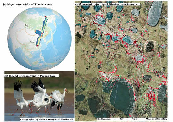
Graphical Abstract

1. Introduction

At particular risk of rapid contemporary habitat loss and the effects of climate change are long-distance northern-hemisphere migratory waterbirds, which traverse extensive stretches of inhospitable terrain between their seasonal exploitation of profitable food resources in temperate wintering areas and the Arctic breeding grounds [1]. The existence of staging areas with rich feeding resources available at the appropriate time and in the appropriate space is also essential for migrating waterbirds to recoup their nutrients and energy stores along their flyway corridors. Hence, the perpetuation of a cohesive network of such sites is especially critical for the effective conservation of such migratory species. Ironically, site protection for such species may be very good in breeding and wintering areas, where waterbirds may aggregate in large numbers for prolonged periods (i.e., several months). In contrast, site safeguarding is often lacking or, at best, uneven between jurisdictions for sites where birds may stage [2,3], despite the fact that these locations may be crucial for individuals to obtain the nutrients and energy necessary for the completion of their migratory episode and the next phase in their annual cycle. Far too often, such staging areas are remote, hard to access, or simply unknown, making it difficult to establish their relative importance within the context of a species’ annual cycle. Our long-term ability to maintain waterbird migratory flyways is heavily dependent on our knowledge, sympathetic management, and protection of sites, including critical breeding, staging, molting, and wintering sites, along migration routes used by bird species. In particular, we need to be able to identify the specific habitat types selected by the birds as feeding areas on staging areas as they move between breeding and survival habitats. Such information is critical to inform effective policy and conservation measures that balance local economic and ecosystem benefits [4].
Fortunately, bird-borne tracking technology has recently undergone major advances, enabling us to remotely track individual avian movement through the physical environments that they inhabit day and night over thousands of kilometers [5,6]. Individual-based tracking data provide unprecedented insight into the ecology, behavior, and physiology of birds in their natural surroundings without the need for human observation [7]. In addition, remote sensing imagery and interpretation further enable the superimposition of individual avian movements on land cover layers, enabling us to determine their habitat use and ultimately providing a basis for the development of sympathetic habitat management strategies on the ground [8].
The critically endangered Siberian crane (Leucogeranus leucogeranus) is the third-rarest crane species in the world, and its population is declining [9]. A recent study estimates that c.3100 birds of this species exist based on a juvenile ratio survey conducted from 2016 to 2019 [10,11], which was divided between two populations. The western/central population breeds in the Russian Arctic tundra south of the Ob River and winters in Iran, along the south coast of the Caspian Sea, and in India, numbering fewer than 20 individuals [12]. The eastern population breeds in Yakutia and winters in China along the flood plains of the Yangtze River, mainly in Poyang Lake. Despite its greater size, the eastern population is threatened by continued wetland loss and degradation and, to an unknown degree, by the diversion of water for human use, agricultural development, the development of oilfields, and the increased human utilization of areas important for the species. Small but seemingly increasing numbers (4–40 individuals) of Siberian cranes have been recorded summering in central and eastern Mongolia during the last two decades, although it remains unknown how these birds relate to the rest of the population and where they migrate during the remainder of the annual cycle. Previous tracking studies have provided forthcoming information about the Siberian crane autumn migration routes and some key staging sites [13,14,15]. Although satellite tracking studies of the Siberian crane were carried out more than 20 years ago, scientists could only obtain rough information on their only one-way (autumn) migration [12,13] due to the technical and equipment limitations that existed at the time. To date, there have been no reports detailing the entire annual round migration cycle of the Siberian crane.
The course resolution of positions from these earlier works means that we still lack sufficient detailed knowledge about the structure of precise migration routes, the extent of migration corridors, habitat use, and the efficacy of current protective measures. These are critical knowledge gaps, which may mean that efforts to save a species are misguided. Here, we report on the use of Siberian cranes fitted with tracking devices of higher spatial resolution to achieve three objectives: Firstly, we seek to define their annual migration parameters and patterns, including the timing and nature of their autumn and spring migration episodes, and to identify specific migration routes and critical stopover areas. Secondly, we seek to describe the extent of the used areas and habitat types of the tagged cranes. Finally, and most importantly, we seek to determine the conservation priorities and current gaps in the current network of protected areas based on the tagged cranes.

2. Materials and Methods

2.1. Tracking Cranes Marked with GPS/GSM Transmitters

Five adult Siberian cranes (Leucogeranus leucogeranus) were captured using helicopters and fitted with satellite transmitters in 1995 (N = 2) and 1996 (N = 3) on the breeding grounds along the lower Indigirka River (71°N, 144–148°E) in northeastern Siberia. These birds were fitted with Nippon Telegraph and Telephone Corporation satellite transmitters, 70 mm × 34 mm × 23 mm in size, weighing 65 g with an external 18 cm antenna (see Supplementary Materials Table S1 for full details of all devices and attachment details). Four birds were captured in 2015 (N = 1), 2016 (N = 1), and 2019 (N = 2) from their summering grounds in the Baruun and Ovoot lake in the Khurkh valley, central Mongolia. The two birds captured between 2015 and 2016 were deployed with backpack-mounted Koeco transmitters, with the GPS location fixes collecting one position per hour. All tracking data collected before 2016 had relatively few irregular GPS fixes (1 to 12 locations per day). The two birds subsequently captured in 2019 were deployed with high-resolution, leg-mounted, solar-powered, waterproof Ornitela GPS transmitters (64 mm×35 mm×32 mm) with internal antennas and a mass of ca. 35 g. All Ornitela devices used in 2019 were fitted to the legs of the cranes and constituted less than 2% of the body mass of the instrumented Siberian cranes used in this study (see Table S1). Three onboard solar panels recharged the onboard batteries, and the low power consumption of the system allowed the base rate collection of positional data (latitude/longitude) by the Ornitela devices at 10-min intervals. The devices can operate from −20 to +70 °C, and they can store 1000 positions without requiring a recharge. The bird ID comprised the species name, year of capture, and serial number. Taking “SC1901” as an example, “SC” represents the Siberian crane, “19” shows that this bird was captured in 2019, and “01” indicates that this is bird number one in this study. All the tracking devices constituted less than 2% of the instrumented Siberian crane body mass in this study (Supplementary Materials Table S1).

2.2. Data Processing

The geoprocessing work was mostly conducted using ArcGIS Pro 2.8 software. Invalid data were filtered to remove rarely recorded but impossible longitudes >180 and latitudes >90. All time values recorded in original date fields from other time zones (mostly UTC time) were converted to UTC + 8 Beijing standard time using the “Convert Time Zone” tool to conduct an hourly scale analysis. In addition, the tracking analyst toolbox in ArcGIS Pro was applied to calculate the distance of bird movements. The distance, duration, and speed between successive time positions along a trajectory were computed by using “Points To Line” function. We estimated the bivariate density at a given grid point x as follows:
P ^ ( x ) = 1 n h 2 i = 1 n k ( d i ( x ) h )
where K(·) is a kernel, h is the bandwidth or smoothing parameter, and di(x) is the distance between the grid point x, and the i-th visited location Xi = (xi, yi) ∈ X. The most common choice for K(·) is a radially symmetric unimodal probability density function, such as bivariate normal density. The kernel density estimation (KDE) was applied to describe the density of cumulative bird use in two-dimensional space. All low-rate data from birds tracked between 2015 and 2016 were linearly interpolated in the time domain to generate a consistently higher rate of tracking data with 10-min intervals for birds tracked in 2019. Four tagged birds generated 312,611 locations after the interpolation, which were used to conduct the kernel density estimation. Bird migration corridors were identified in this way during their annual migration cycle. We separately derived kernel density distribution maps for breeding, summering, stopover, and wintering periods. The average smoothing parameter across all individuals was used for each period as the reference bandwidth. The grid size for the density distribution maps was set to 1 km.

2.3. Defining Migration Parameters

We applied the method of Wang et al. [16] to segment movement tracks into “flight” and “non-flight” periods. We identified stopover sites as all positions where individuals remained for more than 2 days within a particular area (i.e., a cluster of positions within a radius of 30 km and within a period of 48 h [17]). These were highlighted, and we arbitrarily defined the sites where the cranes remained for over 14 days as “critical stopover sites.” If subsequent tracking positions from an individual fell outside of this radius, but the same individual returned to the same stopover site again, those points were still determined to be in the same stopover cluster. We used the Mann–Whitney U tests to test for significant differences between different seasons among birds with long migration routes and between different strategies (migration routes) among birds undergoing autumn migration. All data are expressed as the means ± SD. Data from birds with fine-scale tracking loggers offered high-precision location information, allowing us to identify areas subject to disproportionately high use by the tagged birds. We used the methods described in previous studies [18,19] to analyze crane movements, differentiating sections of the tracking paths into periods of migration between stopover/staging, breeding, or wintering areas, where tracked individuals would still diurnally commute between the feeding and roosting areas but did not undertake long, largely unidirectional movement.

2.4. Land Use and Conservation Status of Key Sites

We characterized the land cover and assessed the effectiveness of the current extent of designated protected areas for the protection of key sites (breeding sites in Russia, summering sites in Mongolia, stopover sites, and wintering sites) used by the tracked cranes. To characterize the land cover for bird GPS fixes within the extent of breeding, summering, stopover, and wintering sites, we used the “Esri 2020 Land Cover” dataset (resolution 10 m × 10 m) produced by Impact Observatory for Esri Inc [20]. The Esri 2020 Land Cover map uses Sentinel-2 satellite imagery with a 10 m resolution and a land classification model to classify the Earth’s surface into 10 categories, namely, crops, water, trees, grass, flooded vegetation, built area, scrub/shrub, bare ground, snow/ice, and clouds for areas with no data. The scrub category mainly represents open areas covered in homogenous grasses with little to no tall vegetation in the study area, confirmed by our field survey. This dataset is based on the dataset produced for the Dynamic World Project by the National Geographic Society in partnership with Google and the World Resources Institute. To assess the conservation status at stopover sites, we downloaded the boundary information from the National Nature Reserves of China, and the World Database of Protected Areas (WDPA 2018; accessed at protectedplanet.net) was used for the areas outside of China (Mongolia and Russia). We overlaid protected area boundaries and critical site extents (breeding in Russia, summering in Mongolia, stopover, and wintering) in ArcGIS Pro 2.8 to identify priority sites and conservation gaps.

3. Results

3.1. Round-Trip Time Budgets and Key Migration Parameters

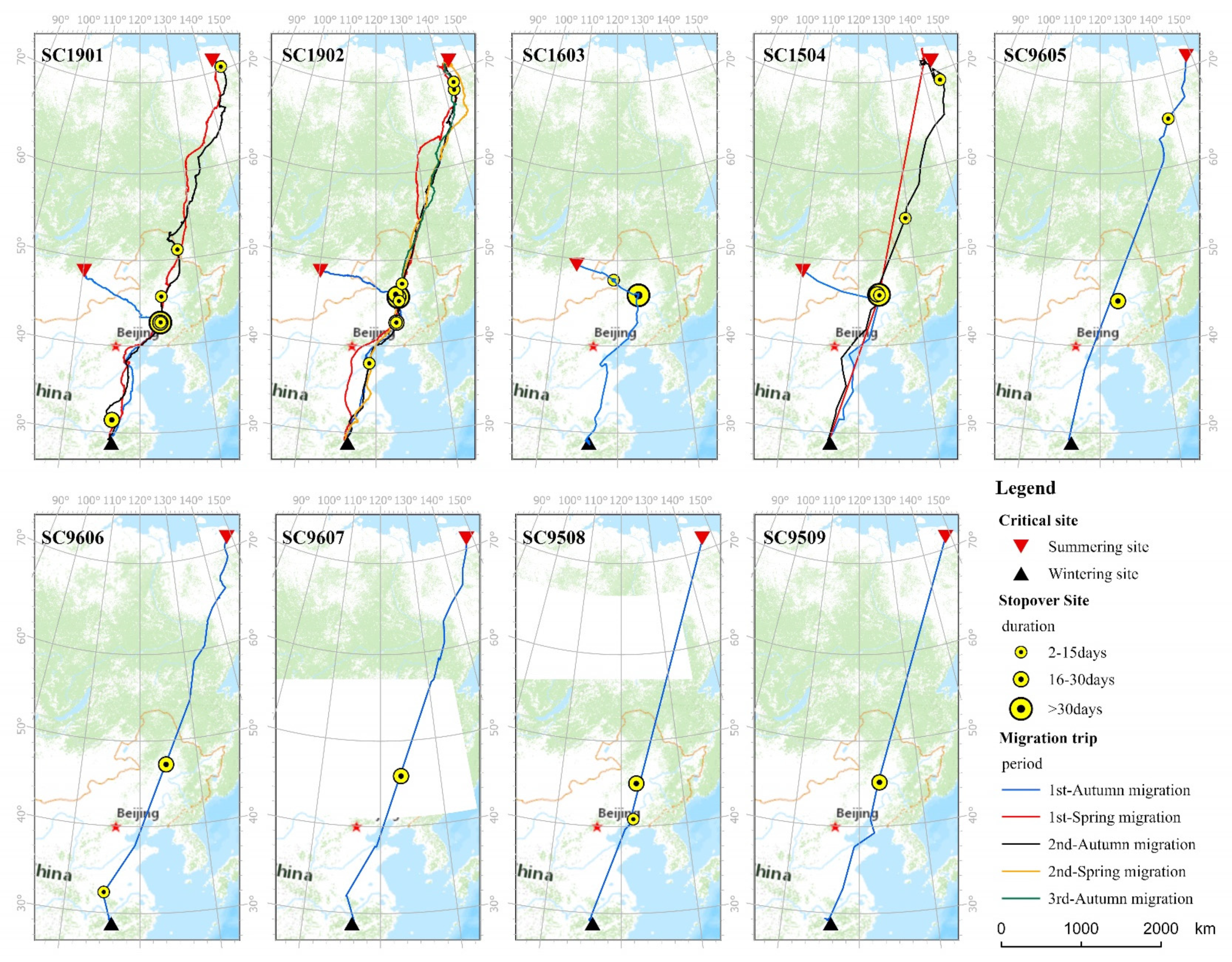
We derived 314,067 bird locations over 3283 bird days from nine individual Siberian cranes, covering 17 full migration trips (13 autumn migration trips and four spring migration trips) from June 1995 to December 2021 (Supplementary Material Tables S1 and S2, and Figure 1 and Figure 2). The birds tagged between 1995 and 1996 were entirely confined in their movements to relatively narrow migratory corridors between breeding areas in Yakutia, Russia, and wintering areas, largely concentrated in the Poyang Lake, China (Figure 2). Data from the four Mongolian individuals tagged in the summers of 2015, 2016, and 2019 in Mongolia showed that these birds were exploiting an area well away from the main, direct migratory corridor between these breeding and wintering grounds (Figure 2). Nevertheless, these individuals all conspicuously moved east to rejoin this migration route by exploiting the same restricted set of autumn staging areas in Northeast China used by cranes returning from the Russia Arctic breeding areas before continuing to the Poyang Lake (Figure 2).
Data from only three out of the nine birds were available for a complete full-year migration cycle between breeding and wintering grounds. These data indicated that these birds covered an average distance of 16,045 km (SC1901: 16,131 km, SC1902: 18,765 km, and SC1504: 13,240 km) during their annual cycle (Figure 1 and Figure 2). Obviously, the birds that summered in Mongolia showed significantly shorter mean autumn migration distances (3323 ± 142 km) than the cranes that summered in Russia (mean 5265 ± 454 km). All nine birds using both migratory corridors from the two differing summer areas used wetlands in Northeast China as their major autumn stopover sites. However, the average staging duration was significantly shorter for the birds that summered in Mongolia (44 ± 5 days) than those that traveled from Yakutia (27 ± 10 days). There was no significant difference in the departure date between the birds traveling from the two summering areas (14 September ± 13 days and 23 September ± 7 days, respectively), largely due to the four Mongolian birds departing much earlier and staging for longer than the Yakutia birds in Northeast China. There was no difference in the departure times from autumn staging areas between these two groups of birds, nor in their arrival time at Poyang Lake in early to mid-November. The tagged Siberian cranes spent an average of 150 days (± 20) on their wintering grounds, departing on 6 April (± 14 days) on average (Figure 1 and Table 1). The tagged Siberian cranes spent almost two months (45 days ± 15) undergoing the spring migration en route to the breeding grounds, where the average date of arrival was 20 May (± 2 days) (Figure 1 and Table 1). The duration of the autumn migration between Yakutia and China (51 days ± 9) was not significantly shorter than that over the same distance in spring (45 days ± 15, Table 1). There were no statistical differences in the stopover number or duration in spring (mean: two stops of 32 days ± 14) versus autumn (two stops of 27 days ± 10) for the same distance traveled (Table 1).
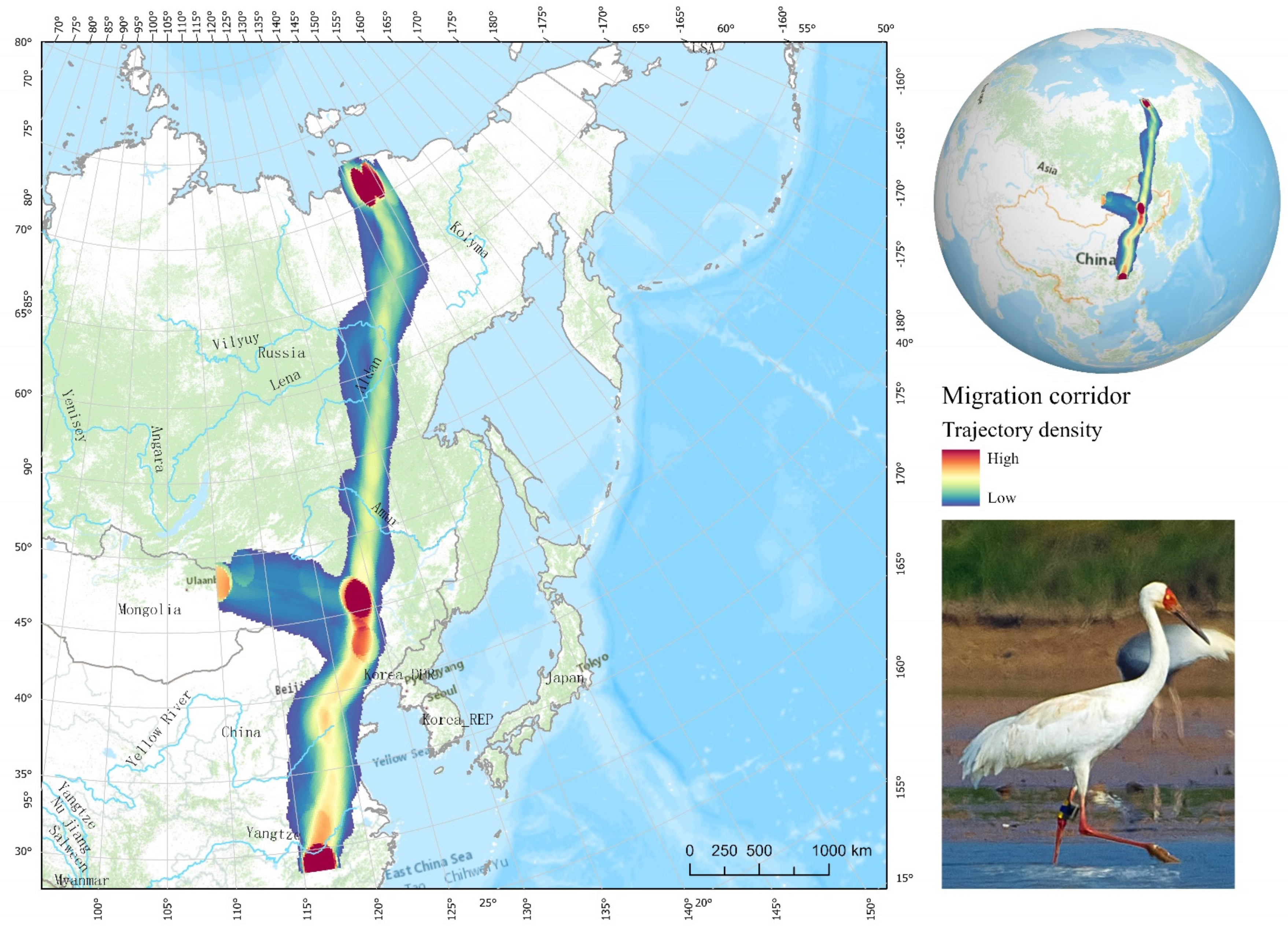
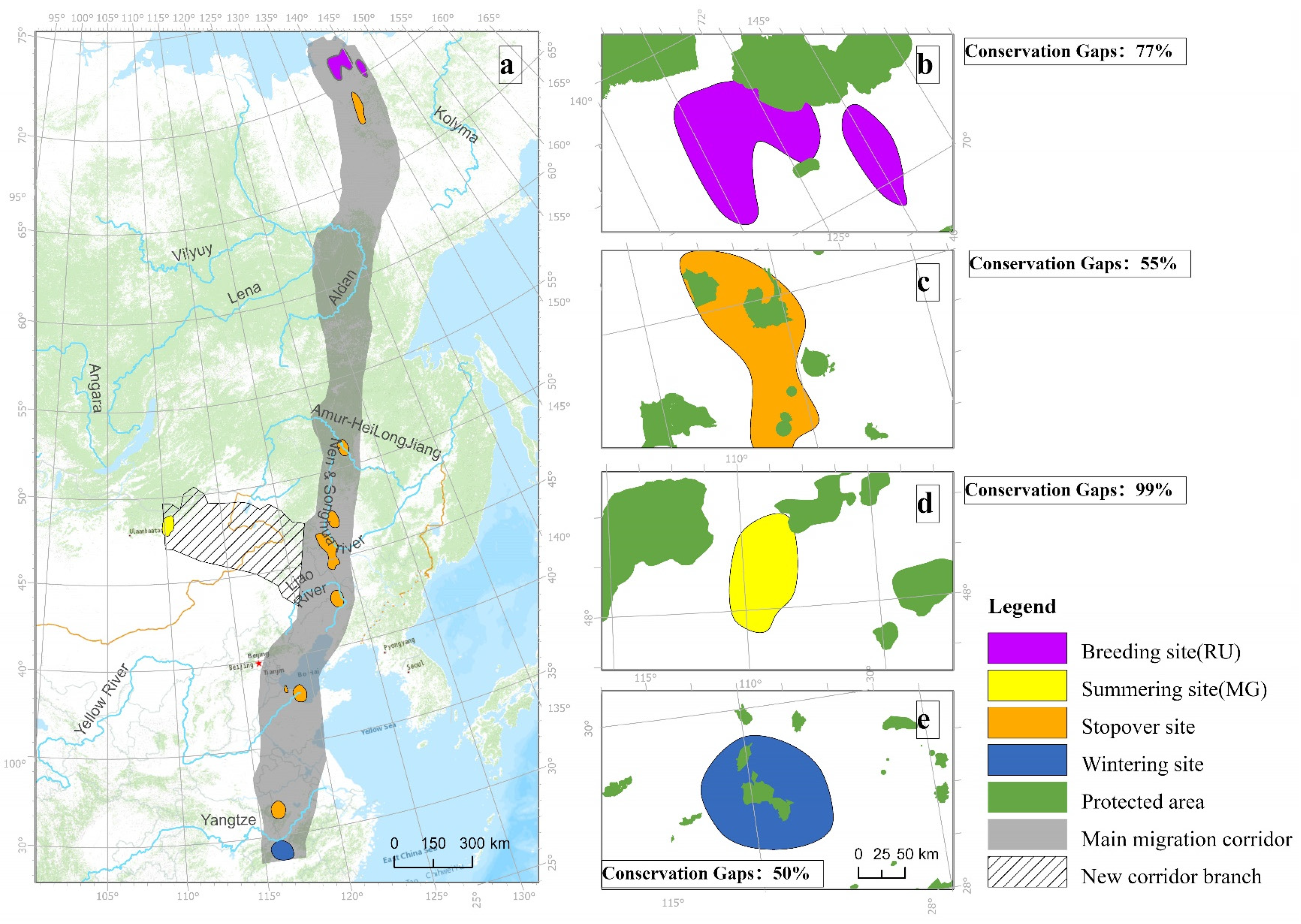
In total, we identified 35 staging sites along the entire flyway, including 17 critical staging sites where birds staged for more than 14 days and 18 stopover sites that supported individuals for more than 2 days. Figure 3 shows the relatively narrow (about 200 km wide) corridor used during both the spring and autumn seasons, interrupted by periods spent at stopover sites, summarized using the kernel density estimation. The result indicates that 90% of the kernel density was represented by the main areas of extent for breeding, summering, stopover, and wintering periods (see Figure 4).

3.2. Extent of Used Areas and Habitat Types of Tagged Cranes

The tracking data confirmed that the species breeds in the vast tundra wetlands in north Chkalov in Allaikhovsky. The total breeding area size is estimated to be 801 km2, of which 23% is protected by the current conservation network, while 77% represents gaps with no protection (Figure 4 and Supplementary Materials Table S5). In total, this study identified 35 staging sites along the entire flyway, which were mainly distributed in the Heilongjiang (Amur) river basin, Nen and Songhua river basin, Liao river basin, Yellow river basin, and Yangtze river basin. The crane trajectories confirmed that the species pauses to rest during migration in Syagannakh, Russia; Petopavlovka in the Heilongjiang (Amur) river basin; Tumuji, Zhalong, and Momoge National Nature Reserves and the Yueliangpao reservoir in the Nen and Songhua river basin; Wolong Lake and Huanzidong wetland park in the Liao river basin; the Yellow River delta in Shandong province; and the Pi river in the Yangtze river basin (Figure 2 and Figure 4). New stopover sites in Petopavlovka in the Heilongjiang (Amur) river basin and the Pi River in Anhui province were first revealed by this study. The total stopover area size was estimated to be 868 km2, of which 55% represents gaps with no protection (Figure 4 and Supplementary Materials Table S5). The summering extent in Mongolia was estimated to be 246 km2, and it receives almost no protection from the current conservation network. The multiple migration trajectories that were repeatedly highlighted confirmed that Poyang Lake has acted as a unique wintering ground over the past ten years. The wintering extent was estimated to be 794 km2, of which 50% represents gaps with no protection (Figure 4 and Supplementary Materials Table S5).
We examined the space and habitat use of the Siberian crane (Leucogeranus leucogeranus) during the breeding/staging/summering/wintering seasons along the entire flyway. All four tagged birds in 2015, 2016, and 2019 generated a total of 312,611 locations, among which 260,693 GPS fixes within the breeding/staging/summering/wintering extents were used to overlay a land cover data layer with a 10 m resolution to identify their traits of habitat use. Figure 5 shows a pattern map of the land cover used for the Siberian crane migration corridor and key sites. In all seasons, the cranes predominantly used water (>43%) as a habitat, almost exclusively so in winter (85%). Still, there were high levels of flooded vegetation at all summering sites and at stopover sites. Grassland was important in the summer (12%), and the birds used croplands to an extent in winter (9%) and to a far greater extent while staging (21%).

4. Discussion

4.1. Migration Patterns and Habitat Use

This study presents a full year-round migration strategy of Siberian cranes. The migration parameters were quantified and compared between spring and autumn for the first time. The Siberian crane undertakes long-distance flights to cross over the taiga forest region, and suitable taiga refueling habitats for these long-distance migrants are lacking [16]. Although the average staging duration was significantly shorter for the birds that summered in Mongolia (44 ± 5 days) than for those that traveled from Yakutia (27 ± 10 days), all nine birds using both migratory corridors from the two differing summer areas used wetlands in Northeast China as their major autumn stopover sites. We found that the Mongolian birds that undertake shorter migration trips leave their summering grounds earlier and choose to stay longer at the stopover sites in Northeast China than Yakutia birds. They basically leave on 14 September ± 13 days, which may be due to a shortage of daylight or another reason resulting in food no longer being available at the summering grounds in Mongolia. The habitat requirements of migratory birds can be dynamic during the annual cycle, and understanding habitat use during the breeding/staging/summering/wintering seasons is important for conservation planning. Long-distance migratory Siberian cranes also respond to weather, geography, food sources, day length, and other factors. As a result, their migration trajectories are meandering, tortuous tracks rather than straight lines. Birds routinely migrate in order to fly far away from areas of low or decreasing resources to areas of high or increasing resources, of which the two primary resources being sought are food and nesting locations. Cranes that nest in the northern hemisphere tend to migrate northward in the spring in order to take advantage of the burgeoning insect populations, budding plants, and the abundance of nesting locations. As winter approaches and the availability of insects and other food drops, the birds move to the south. Escaping the cold is a motivating factor, but many species can withstand freezing temperatures as long as an adequate food supply is available. There was a significantly lower value for the straightness index of the migration paths (0.66 ± 0.02) than for the four tracks summered in Russia (0.88 ± 0.08) (Table 1). From central Mongolia to the wintering sites, the birds significantly changed direction between these steps and took a large detour via Northeast China.
Habitat use is often determined by the land cover/use structure features associated with food resources or thermal environments. In the breeding region in Yakutia, scrub and flooded vegetation were highly used, representing over 70% of use. In the staging region, the birds were also found to forage over 20% of food resources from croplands. In the summering sites in Mongolia, the birds mainly used the scrub, water, flooded vegetation, and grassland, while in the wintering grounds, the natural wetlands at Poyang Lake offered over 80% of food resources and a roosting environment, and croplands were also shown to play an important role in the wintering grounds. We surprisingly found that the birds risk flying to artificial paddy fields to refuel themselves for two or three weeks before they start their thousand-kilometer spring migration trips.

4.2. Conservation Priorities and Gaps in Large River Basins

This study identified 35 staging sites along the entire flyway in total, which were mainly located in the floodplains around the lakeshore area and large river basins. The cranes from Poyang Lake were found to be highly conservative, with most stopping at only three to five staging sites when migrating northward to the Arctic region through Northeast China. The large east-west river basins provide an abundance of floodplain wetlands that act similar to a ’flight of steps, ‘offering key stopover sites in the long-distance north-south migration trip for Siberian Cranes. The birds completed an approximately 11,000 km-long circuit during which they only landed in several regions and large river basins: Syagannakh, Russia; Petopavlovka in the Heilongjiang (Amur) river basin; Tumuji, Zhalong, and Momoge National Nature Reserves and the Yueliangpao reservoir in the Nen and Songhua river basin; Wolong Lake and Huanzidong wetland park in the Liao river basin; the Yellow River delta in Shandong province; and the Pi river in the Yangtze river basin (Figure 2 and Figure 4). The Siberian crane does not comply with the principle that the timing of this mid-season migration move should depend on the snowy conditions at the breeding grounds and staging sites [21]. The ground survey shows that thousands of Siberian cranes were still living at their staging sites after a big cold wave with heavy snow in Northeast China in November 2021. Our research highlights the need for regional management strategies that consider the full annual cycle and daily movement patterns of Siberian cranes. The birds were found to stage more frequently in Northeast China after crossover the far east taiga forest region during their southward migration trip. Maintenance and effective conservation of the remaining Siberian crane habitat is urgently needed and extremely challenging in those areas. The conservation status of Siberian cranes is currently inadequate to protect the species: 64% of the total number of proposed priority sites remain unprotected. Some critical habitats are not included within the boundaries of specific protected areas, especially in summering grounds (unprotected breeding in Russia: 77%; stopover: 55%; summering in Mongolia: 99%; and wintering: 50%) (Figure 4).

4.3. High Fidelity and Conservation in Poyang Lake

Our results indicate that, although the Siberian crane is a long-distance migratory bird, it chooses Poyang Lake as its wintering grounds. This fact was confirmed by both our tracking data and a local bird watcher. Amazingly, after 650 days of flying healthily since being tracked, bird SC1902, with our satellite logger, was sighted and photographed by a birdwatcher (Xiaohua Wang) at Poyang Lake on 15 March 2021. Our results and previous analysis repeatedly confirm that Poyang Lake is the most outstanding of the globally important Yangtze River Floodplain wetlands due to the biodiversity and ecosystem services that it supports [22,23]. We recognized that, to date, it is the most important wintering site for northern-hemisphere water birds in Eastern Asia [24,25]. Poyang Lake supports over half a million waterbirds that are shared with many other countries, and they are protected under international agreements. Despite the super high level of site protection enjoyed by China’s most outstanding freshwater wetland nature reserve at Poyang Lake, as discussed above, the site and the species continue to be under threat. The proposed Poyang Dam may represent a major threat to the delicate hydrology and dynamic nature of the biota of the site, especially for Siberian cranes for whom Poyang Lake is a unique wintering site [26,27]. We urge that a comprehensive international environmental impact assessment of the proposed dam and its consequences be conducted before commencing construction.

4.4. Climate Changes and Human Activities Impact on Cranes

Bird populations may also be subjected to limiting factors through the mortality rates associated with particular breeding and wintering sites due to human activities and climate change. Specifically, increasing local temperatures during the summering period have been suggested to be a long-term driver of this pattern for many long-distance migrant species. Severe droughts and frequent wildfires have been reported in Siberian crane breeding grounds, including in both Mongolia and Russia Siberia [28,29,30]. There has been a rapid loss of lakes on the Mongolian plateau in recent decades. The number of lakes with a water surface area of over one kilometer squared decreased from 785 in the late 1980s to 577 in 2010 in the Mongolian Plateau [31]. During the extreme fire season in Siberia in 2020, high-resolution satellite data from the European Space Agency’s Sentinel-2 detected fires around still-frozen thermokarst lakes above 70◦ N [30]. The occurrence of these extreme climate events at Siberian crane breeding sites may cause a notable decrease in the population by impacting the reproductive rate. Another study indicated that Siberian crane numbers sharply decreased in the later period of the wetland restoration project to 10–40% of the values prior to restoration in the Momoge National Nature Reserve, China [32]. During the project, the average daily water level rose to approximately 60 cm, which was too high for the healthy growth of S. planiculmis, the primary food source of the Siberian crane. Hence, the birds may have been forced to develop new migration routes in order to avoid the negative effects of extreme climate events and anthropogenic activities on the reproduction of their populations.

5. Conclusions

The fine-scale tracking data collected in this study demonstrate the huge annual movement range of Siberian cranes. This study provides the most accurate and detailed information obtained on the species to date that, in contrast to that obtained from previous lower-frequency tracking studies, can be used to generate revised expectations for strategies and movement patterns. This study precisely quantified 11 full year-round migration parameters, namely, the departure date, arrival date, migration duration (days), migration distance (km), migration speed (km/day), number of stopovers, stopover duration (days), migration bout length (km), travel duration (day), travel speed (km/day), and straightness index. These results differ by species compared with those obtained from previous, lower frequency tracking studies, leading to the generation of revised expectations for life history traits or strategies and movement patterns. By obtaining better information on the movement trajectories with higher frequency data, we identified previously undetected movement patterns that are likely to be related to specific behaviors. Despite the generation of a considerable amount of new knowledge from bird trajectory data mining, we should be prudent about not concluding too much from a limited sample of nine Siberian cranes, which may not be typical of the population size. Hence, more individuals from a greater area of the breeding range in Russia are needed for future tracking to add to our knowledge of the flyway definition and important staging areas. Siberian cranes now slightly increasingly aggregate at their wintering ground at the Poyang Lake in the Yangtze River Floodplain. However, the western/central population of Siberian cranes is almost extinct, and this population has not been sighted in its wintering grounds in Keoladeo National Park since 2001. Ornithologists speculate that Siberian cranes may skip India indefinitely, as the flock that used to visit India has no remaining members left who remember the route [33]. In this case, this makes the species all the more vulnerable to disease and human disturbance due to their concentration. Nevertheless, this study shows how satellite tracking, combined with spatial analyses, can improve our understanding of the factors that drive various movements, especially through identifying habitat use and holes in our current site-safeguarding network for threatened species. There also needs to be assessments of the levels of sympathetic management of such habitats and site protection, information that is essential for the conservation management of habitats used by the species. We still believe that more individual Siberian cranes should be tracked in the near future to allow us to understand the year-round pressures on the species more fully.

Supplementary Materials

The following supporting information can be downloaded at: https://www.mdpi.com/article/10.3390/rs14205101/s1.

Author Contributions

K.Y. conceived this study. J.Z. coded the migration parameters calculation. N.B. and T.N. conducted the field survey, bird capture, transmitter deployment, and measurements. K.Y. wrote the initial draft of the paper, with substantial editorial input from H.H. and I.P.B. All authors have read and agreed to the published version of the manuscript.

Funding

This research was funded by the National Key Research and Development Program of China (Grant No.2022YFF1300900), the National Natural Science Foundation of China (Grant Nos. 31870369 and 32271674), the Joint CAS-MPG research project (Grant No. HZXM20225001MI), China Biodiversity Observation Networks (Sino BON), the Scientific Instrument Developing Project of the Chinese Academy of Sciences (Grant No. YJKYYQ20180050) and International Crane Foundation. The research in the 1990s was sponsored by the NEC Corporation and supported by the NTT Corporation of Japan.

Data Availability Statement

As the data also form part of an ongoing study, the raw/processed data required to reproduce these findings cannot be shared at this time.

Acknowledgments

Thanks go to the Animal Ethics Committee, Research for Eco-Environmental Sciences, and Chinese Academy of Sciences, who approved this study, and for approval for bird capture and logger deployment in Mongolia obtained from the Ministry of Nature, Environmental and Tourism of Mongolia (permissions 06/2564 and 06/2862). The authors are grateful to the anonymous reviewers for their insightful and helpful comments that have helped to improve the original manuscript.

Conflicts of Interest

The authors declare no conflict of interest.

References

  1. Dalby, L.; McGill, B.J.; Fox, A.D.; Svenning, J.C. Seasonality drives global-scale diversity patterns in waterfowl (A nseriformes) via temporal niche exploitation. Global. Ecol. Biogeogr. 2014, 23, 550–562. [Google Scholar] [CrossRef]
  2. Deng, X.; Zhao, Q.; Zhang, J.; Kolzsch, A.; Solovyeva, D.; Bysykatova-Harmey, I.; Xu, Z.; Kruckenberg, H.; Cao, L.; Fox, A.D. Contrasting habitat use and conservation status of Chinese-wintering and other Eurasian Greater White-fronted Goose (Anser albifrons) populations. Avian Res. 2021, 12, 71. [Google Scholar] [CrossRef]
  3. Damba, I.; Zhang, J.; Yi, K.; Dou, H.; Batbayar, N.; Natsagdorj, T.; Davaasuren, B.; Cao, L.; Fox, A.D. Seasonal and regional differences in migration patterns and conservation status of Swan Geese (Anser cygnoides) in the East Asian Flyway. Avian Res. 2021, 12, 73. [Google Scholar] [CrossRef]
  4. Donnelly, J.P.; King, S.L.; Knetter, J.; Gammonley, J.H.; Dreitz, V.J.; Grisham, B.A.; Nowak, M.C.; Collins, D.P. Migration efficiency sustains connectivity across agroecological networks supporting sandhill crane migration. Ecosphere 2021, 12, e03543. [Google Scholar] [CrossRef]
  5. Lopez-Lopez, P. Individual-Based Tracking Systems in Ornithology: Welcome to the Era of Big Data. Ardeola-Int. J. Ornithol. 2016, 63, 103–136. [Google Scholar] [CrossRef] [Green Version]
  6. Harcourt, R.; Sequeira, A.M.M.; Zhang, X.; Roquet, F.; Komatsu, K.; Heupel, M.; McMahon, C.; Whoriskey, F.; Meekan, M.; Carroll, G.; et al. Animal-Borne Telemetry: An Integral Component of the Ocean Observing Toolkit. Front. Mar. Sci. 2019, 6, 326. [Google Scholar] [CrossRef] [Green Version]
  7. Westley, P.A.H.; Berdahl, A.M.; Torney, C.J.; Biro, D. Collective movement in ecology: From emerging technologies to conservation and management. Philos. Trans. R. Soc. Lond. Ser. B Biol. Sci. 2018, 373, 20170004. [Google Scholar] [CrossRef] [PubMed]
  8. McGowan, J.; Possingham, H.P. Commentary: Linking Movement Ecology with Wildlife Management and Conservation. Front. Ecol. Evol. 2016, 4, 30. [Google Scholar] [CrossRef] [Green Version]
  9. Bysykatova, I.P.; Krapu, G.L.; Germogenov, N.I.; Buhl, D.A. Distribution, densities, and ecology of Siberian cranes in the Khroma River region of northern Yakutia in northeastern Russia. In Proceedings of the North American Crane Workshop, Lafayette, Louisiana, 14–17 April 2014; pp. 50–64. Available online: https://digitalcommons.unl.edu/nacwgproc/381 (accessed on 18 April 2019).
  10. Wang, Y.; Damba, I.; Zhao, Q.; Xie, Y.; Deng, X.; Ga, R.; Liu, G.; Xu, Z.; Li, Y.; Gao, D.; et al. Organising a juvenile ratio monitoring programme for 10 key waterbird species in the Yangtze River floodplain: Analysis and proposals. Avian Res. 2021, 12, 72. [Google Scholar] [CrossRef]
  11. Wang, Y. Study on Population Dynamics of 10 Waterbirds in Wetlands of Middle and Lower Reaches of Yangtze River. Master’s Thesis, University of Science and Technology of China, HeFei, China, 2021. [Google Scholar]
  12. Kanai, Y.; Nagendran, M.; Ueta, M.; Markin, Y.; Rinne, J.; Sorokin, A.G.; Higuchi, H.; Archibald, G.W. Discovery of breeding grounds of a Siberian Crane Grus leucogeranus flock that winters in Iran, via satellite telemetry. Bird Conserv. Int. 2002, 12, 327–333. [Google Scholar] [CrossRef]
  13. Kanai, Y.; Ueta, M.; Germogenov, N.; Nagendran, M.; Mita, N.; Higuchi, H. Migration routes and important resting areas of Siberian cranes (Grus leucogeranus) between northeastern Siberia and China as revealed by satellite tracking. Biol. Conserv. 2002, 106, 339–346. [Google Scholar] [CrossRef]
  14. Xue, L.; Xu, J.; Li, X.; Wu, A.; Qian, F. The difference of migration routes and movement patterns between the rescued and the wild Siberian Crane. Acta Ecol. Sin. 2020, 40, 2367–2375. [Google Scholar]
  15. Li, M.; Qian, F.; Wu, A.; Pan, K.; Wu, T. Identification of Important Stopover Sites for Siberian Cranes and Changes of Their Land Use Patterns. Wetl. Sci. 2021, 19, 304–316. [Google Scholar]
  16. Wang, X.; Cao, L.; Bysykatova, I.; Xu, Z.; Rozenfeld, S.; Jeong, W.; Vangeluwe, D.; Zhao, Y.; Xie, T.; Yi, K.; et al. The Far East taiga forest: Unrecognized inhospitable terrain for migrating Arctic-nesting waterbirds? Peerj 2018, 6, e4353. [Google Scholar] [CrossRef]
  17. Koelzsch, A.; Mueskens, G.J.D.M.; Kruckenberg, H.; Glazov, P.; Weinzierl, R.; Nolet, B.A.; Wikelski, M. Towards a new understanding of migration timing: Slower spring than autumn migration in geese reflects different decision rules for stopover use and departure. Oikos 2016, 125, 1496–1507. [Google Scholar] [CrossRef] [Green Version]
  18. van Wijk, R.E.; Kolzsch, A.; Kruckenberg, H.; Ebbinge, B.S.; Muskens, G.; Nolet, B.A. Individually tracked geese follow peaks of temperature acceleration during spring migration. Oikos 2012, 121, 655–664. [Google Scholar] [CrossRef] [Green Version]
  19. Deng, X.; Zhao, Q.; Fang, L.; Xu, Z.; Wang, X.; He, H.; Cao, L.; Fox, A.D. Spring migration duration exceeds that of autumn migration in Far East Asian Greater White-fronted Geese (Anser albifrons). Avian Res. 2019, 10, 19. [Google Scholar] [CrossRef] [Green Version]
  20. Esri. Sentinel-2 10m Land Use/Land Cover Time Series. Available online: https://www.arcgis.com/home/item.html?id=d3da5dd386d140cf93fc9ecbf8da5e31 (accessed on 10 February 2022).
  21. Li, H.; Fang, L.; Wang, X.; Yi, K.; Cao, L.; Fox, A.D. Does snowmelt constrain spring migration progression in sympatric wintering Arctic-nesting geese? Results from a Far East Asia telemetry study. Ibis 2020, 162, 548–555. [Google Scholar] [CrossRef] [Green Version]
  22. Aharon-Rotman, Y.; McEvoy, J.; Zheng, Z.; Yu, H.; Wang, X.; Si, Y.; Xu, Z.; Yuan, Z.; Jeong, W.; Cao, L.; et al. Water level affects availability of optimal feeding habitats for threatened migratory waterbirds. Ecol. Evol. 2017, 7, 10440–10450. [Google Scholar] [CrossRef]
  23. Zhang, Y.; Fox, A.D.; Cao, L.; Jia, Q.; Lu, C.; Prins, H.H.T.; de Boer, W.F. Effects of ecological and anthropogenic factors on waterbird abundance at a Ramsar Site in the Yangtze River Floodplain. Ambio 2019, 48, 293–303. [Google Scholar] [CrossRef]
  24. Cao, L.; Meng, F.; Zhao, Q. Understanding Effects of Large-scale Development on Bird Migration and Habitats Through Cutting Edge Avian Monitoring Techniques. Bull. Chin. Acad. Sci. 2021, 36, 436–447. [Google Scholar]
  25. Cao, L.; Meng, F.; Zhang, J.; Deng, X.; Sawa, Y.; Fox, A.D. Moving forward: How best to use the results of waterbird monitoring and telemetry studies to safeguard the future of Far East Asian Anatidae species. Wildfowl 2020, 6, 293–319. [Google Scholar]
  26. Jia, Y.; Guan, L.; Wang, Y.; Liu, G.; Lei, G.; Wen, L. Combining Population Growth Model and Generalized Additive Model to Determine Optimal Water Level FOR Waterbird Conservation: A Case Study of Siberian Crane (Leucogeranus Leucogeranus) in Lake Poyang, China. River Res. Appl. 2016, 32, 100–109. [Google Scholar] [CrossRef]
  27. Jia, Y.F.; Jiao, S.W.; Zhang, Y.M.; Zhou, Y.; Lei, G.C.; Liu, G.H. Diet Shift and Its Impact on Foraging Behavior of Siberian Crane (Grus Leucogeranus) in Poyang Lake. PLoS ONE 2013, 8, e65843. [Google Scholar] [CrossRef]
  28. Bayartogtokh, B.; Munkhchuluun, B.; Jargalsaikhan, P.; Bayarsaikhan, U. Khar Yamaat Nature Reserve: Biodiversity, Ecosystem Features, Threats and Conservation Management. Mong. J. Biol. Sci. 2020, 19, 3–15. [Google Scholar] [CrossRef]
  29. Kharuk, V.I.; Ponomarev, E.I.; Ivanova, G.A.; Dvinskaya, M.L.; Coogan, S.C.; Flannigan, M.D. Wildfires in the Siberian taiga. Ambio 2021, 50, 1953–1974. [Google Scholar] [CrossRef]
  30. McCarty, J.L.; Aalto, J.; Paunu, V.-V.; Arnold, S.R.; Eckhardt, S.; Klimont, Z.; Fain, J.J.; Evangeliou, N.; Venäläinen, A.; Tchebakova, N.M.; et al. Reviews and syntheses: Arctic fire regimes and emissions in the 21st century. Biogeosciences 2021, 18, 5053–5083. [Google Scholar] [CrossRef]
  31. Tao, S.; Fang, J.; Zhao, X.; Zhao, S.; Shen, H.; Hu, H.; Tang, Z.; Wang, Z.; Guo, Q. Rapid loss of lakes on the Mongolian Plateau. Proc. Natl. Acad. Sci. USA 2015, 112, 2281–2286. [Google Scholar] [CrossRef] [Green Version]
  32. Jiang, H.B.; Wen, Y.; Zou, L.F.; Wang, Z.Q.; He, C.G.; Zou, C.L. The effects of a wetland restoration project on the Siberian crane (Grus leucogeranus) population and stopover habitat in Momoge National Nature Reserve, China. Ecol. Eng. 2016, 96, 170–177. [Google Scholar] [CrossRef]
  33. Bose, R. Siberian Cranes May Skip India Forever. Available online: https://www.thegoan.net/goa-news/siberian-cranes-may-skip-india-forever/545.html (accessed on 22 August 2012).
Figure 1. Schematic overview of movement patterns of the telemetered Siberian crane (Leucogeranus leucogeranus) followed from their breeding areas to the Poyang Lake wintering area (autumn migration (N = 13): left; spring migration: right (N = 4)). DOY abbreviation stands for the day of the year.
Remotesensing 14 05101 g001
Figure 2. Migration routes and critical sites of nine Siberian cranes (Leucogeranus leucogeranus).
Remotesensing 14 05101 g002
Figure 3. Mapping of Siberian crane (Leucogeranus leucogeranus) migration corridors, based on trajectories of the density estimation summarization of the migration routes of four tracked individuals. Bird SC1902, with our satellite logger, was sighted and photographed by a birdwatcher (Xiaohua Wang) at Poyang Lake on 15 March 2021, 649 days after being tracked on 5 June 2019.
Remotesensing 14 05101 g003
Figure 4. Mapping of the Siberian crane (Leucogeranus leucogeranus) flyway structure. (a) Maps of the main migration corridors and new corridor branch. (be) Maps of critical habitat extents used in the breeding, staging/stopover, summering, and wintering periods, as confirmed by the GPS fixes using kernel density estimation (KDE).
Remotesensing 14 05101 g004
Figure 5. Mapping of the land cover traits of the Siberian crane (Leucogeranus leucogeranus) migration corridor. (a) Land cover maps of the migration corridor. (be) Land cover map of breeding in Russia, stopover, summering in Mongolia, and wintering extents, respectively. (fi) Patterns of land cover used derived from the bird GPS fixes within the breeding, stopover, summering, and wintering extents, respectively. The scrub category mainly represents open areas covered in homogenous grasses with little to no tall vegetation in the study area, which was confirmed by our field survey.
Remotesensing 14 05101 g005
Table 1. Statistical comparison of the key spring and autumn migration parameters of nine Siberian cranes (Leucogeranus leucogeranus) based on the Mann–Whitney U tests.
ParameterLong Migration
(Mean ± SD)
U-Test on Seasonal DifferenceShort Migration (Mean ± SD)U-Test on Strategy Difference
SpringAutumnWp ValueAutumnWp-Value
Departure date6 April ± 1423 September ± 7--14 September ± 138.50.16
Arrival date20 May ± 214 November ± 7--5 November ± 1080.14
Migration duration
(day)
45 ± 1551 ± 9240.4152 ± 418.51.00
Migration distance
(Km)
5604 ± 3625265 ± 454150.713323 ± 14235<0.01
Migration speed
(km/day)
134 ± 40106 ± 2327.50.1664 ± 54<0.05
Number of stopovers2 ± 12 ± 180.151 ± 00<0.01
Stopover duration
(day)
32 ± 1427 ± 1010.50.2844 ± 50<0.01
Step length
(km)
2226 ± 7601854 ± 64290.201525 ± 297270.20
Travel duration
(day)
14 ± 324 ± 14120.418 ± 1110.33
Travel speed
(km/day)
430 ± 114299 ± 176220.57391 ± 4090.16
Straightness index0.88 ± 0.050.92 ± 0.0626.50.220.66 ± 0.020<0.01
Publisher’s Note: MDPI stays neutral with regard to jurisdictional claims in published maps and institutional affiliations.