Abstract
The documentation and protection of archaeological and cultural heritage (ACH) using remote sensing, a non-destructive tool, is increasingly popular for experts around the world, as it allows rapid searching and mapping at multiple scales, rapid analysis of multi-source data sets, and dynamic monitoring of ACH sites and their environments. The exploitation of remote sensing data and their products have seen an increased use in recent years in the fields of archaeological science and cultural heritage. Different spatial and spectral analysis datasets have been applied to distinguish archaeological remains and detect changes in the landscape over time, and, in the last decade, archaeologists have adopted more thoroughly automated object detection approaches for potential sites. These approaches included, among others, object detection methods, such as those of machine learning (ML) and deep learning (DL) algorithms, as well as convolutional neural networks (CNN) and deep learning (DL) models using aerial and satellite images, airborne and spaceborne remote sensing (ASRS), multispectral, hyperspectral images, and active methods (synthetic aperture radar (SAR) and light detection and ranging radar (LiDAR)). Researchers also refer to the potential for archaeologists to explore such artificial intelligence (AI) approaches in various ways, such as identifying archaeological features and classifying them. Here, we present a review study related to the contributions of remote sensing (RS) and artificial intelligence in archaeology. However, a main question remains open in the field of research: the rate of positive contribution of remote sensing and artificial intelligence techniques in archaeological research. The scope of this study is to summarize the state of the art related to AI and RS for archaeological research and provide some further insights into the existing literature.
1. Introduction
Archeology is a science with an object of study and research related to history, but also the activity of people who lived in earlier times, through finds in the natural environment, monuments of art, and the products of human labor, such as coins, vessels, tools, and various feature remains, such as mounds and graves. One of the most popular techniques for the detection of archaeological sites, remains, and description of past landscape uses is the pedestrian archaeological survey, with fieldwalking being the most common type of this type of survey [1]. It is a fact that many archaeological sites have been discovered by searching for evidence in historical maps or texts, while others have been discovered almost by accident during other construction projects. However, with field survey, archaeologists try to determine the nature and extent of visible remains, which leads to an improved range of interpretations. This result provides the impetus for further field research for the purpose of documentation [2]. The aim of the next steps is the clarification of written records and the filling of any knowledge gaps. Alcock and Cherry [3] estimated that, by the beginning of the 21st century, millions of hectares of the Mediterranean alone had been surveyed, with a significant increase in survey activity since then.
Nevertheless, a high rate of false positives can be reported during the traditional pattern recognition methods, and therefore remote sensing approaches blended with computational approaches may contribute to extracting information from field data in a systematic way.
When referring to remote sensing for archeology, various types of remote sensing technologies are included, such as, more specifically, satellite remote sensing, aerial photography, geophysical research, and unmanned aerial vehicles (UAVs). Therefore, remote sensing, in its broadest sense and in relation to archaeology, includes methods aimed at discovering and mapping archaeological sites and remains of past civilizations, which are located either above or below ground level, and which are conducted in such a way that these objects are not touched, disturbed, or even destroyed. [4]. The first commercial very high-resolution satellite, with 1 m panchromatic spatial resolution, was IKONOS, the launch of which was achieved at the end of the 20th century (1999) and represented a significant improvement for archaeological research applications. A key advantage is its ability to provide systematic multispectral data in archaeological sites and monuments [4]. Since then, satellite remote sensing has been used to detect many archaeological sites around the world.
RS science has been progressively applied for supporting archaeological research in recent years [5,6]. Technological innovation and improvements of space-based sensors, in terms of their spatial and spectral resolution, as well as the adoption of open access and freely distribution of satellite datasets (see Landsat and Sentinel products), have motivated the further use of space-based remote sensing applications [7]. In addition, the democratization of low altitude systems, with drones at relevant low costs, has been widely adopted in the last decade in archaeological research mainly for documentation purposes [8]. At the same time, archaeological computational approaches have shifted from desktop-based applications to cloud-based approaches blended with advanced AI algorithms [1]. As these changes have taken place in a relevant short period (a decade), one can argue that we are still in the beginning of a new era of so-called “remote sensing archaeology”.
This review article focuses on the contribution of AI and RS to archaeological research. The extensive literature review shows a surge of research around the use of AI methods in archeology. Nevertheless, a main question arises and remain open in the field of research: the future and the contribution of RS and AI techniques in archaeological research.
2. Archaeological Surface Survey
2.1. Systematic Surface Surveys
Archaeological remains can be objects or even some remains of buildings that were either destroyed or simply abandoned. These may be found on the surface of the landscape, but there are also other cases that have been buried either due to natural phenomena or due to human factors. The latest features may come to the surface again in the future as part of an archaeological excavation or by accident.
For landscape surface remains studies, the most common method is surface research, known as walking, surface collection etc. for the indication of possible buried remains using surveys, management, and protection from the ever rapidly changing modern landscape. According to [9], the surface survey includes quite a few stages according to: (a) the characteristics of the area under investigation; (b) the amount of data available from previous research; (c) research questions; and (d) available resources, including cost limitations.
Usually, surface surveying involves methodical walking by teams of archaeologists with the aim of recording archaeological remains visible on the surface, usually fragments of pottery (“sherds”). As stated by [1], the analysis of the dispersion of these remains related to the human presence in our past provides researchers with information, such as the change of landscape use and the destruction or disappearance of entire settlements.
2.2. Applications of Systematic Surface Surveys
During the 1950s–1960s, archaeological research developed as a branch and soon evolved bringing to light major archaeological finds. Alcock and Cherry [3] referred to an increase in the interest and activity of archaeological investigations since the beginning of the 21st century [1,10,11,12].
Archaeological surface research can be applied both to whole areas or part of them with the main goal of (re)discovering new archaeological sites and remains. It is also applied to already known sites of archaeological interest with the aim of adding further knowledge to the existing ones regarding the nature and structure of the antiquities. However, we should emphasize that covering large areas can be extremely expensive, as well as time-consuming.
As a method, while it is relatively simple, the evaluation of the results can be extremely problematic due to various factors. With surface survey, we can detect and record anything that is exposed and visible on the surface. Therefore, the success of the research is further based on factors that affect this visibility, such as, for example, the density of vegetation, the slope of the subsoil, etc. It is therefore understandable that the method of this research will be more successful when applied to areas that are generally arid and semi-arid compared to more temperate regions where the remains of antiquities are buried. In the last case, surface research is applied when buried archaeological remains come to a visible point on the surface of the landscape.
Therefore, a key factor for the success of surface research is the visibility of the landscape, which is affected by both climate change and anthropogenic factors that destroy archaeological records. The disappearance of archaeological landscapes is a major challenge for 21st century archeology, but it is made more problematic by unrecorded evidence [13]. Excluded areas for investigation are usually agricultural land and forested areas, which during the research period, were not accessible due to various reasons. These include, among other things, the existence of intense vegetation, difficulty of the ground (slope, highly eroded areas), or even existing constructions, such as public or private properties, roads which prevent access to the researchers, etc. Nevertheless, these research barriers are very likely to be only a part of the landscape area under investigation. Consequently, this may generate an inconsistent distribution of the archaeological report.
Another factor that affects the success of surface research is the methodology itself that is followed during the research, which may not be sufficient or even reliable. As the collection and recording of the visible findings is subjective, non-trained personnel may add “noise” to the overall findings. Therefore, there is a difficulty regarding the correct evaluation of the results and the validity in their interpretation to consider the research objectives successful.
We, therefore, conclude that surface survey is a relatively straightforward survey method but, at the same time, its success and correctness is multifactorial. As surface survey has been long adopted in archaeological practice, its implementation can be further improved through remote sensors. This is also highlighted by recent articles [1,14]. We can therefore integrate other complementary methods into the surface survey, such as earth observation sensors, low-altitude sensors, AI processing techniques, as well as aerial LiDAR data, which have been increasingly valuable tools for locating, visualizing, and understanding cultural heritage sites [15].
3. Remote Sensing in Archaeology
3.1. Literature Growth
The science of remote sensing is an achievement of the evolution of technology and is used to analyze and process both satellite and terrestrial spatial data with the use of appropriate accounting programs and computers [16]. Numerous definitions have been given from time to time for what remote sensing is but, basically, we would say that it is the art or science of explaining something about an object without touching it [17]. Campbell and Wynne [16] argue in more detail that remote sensing is the practice of extracting information about the land and water surface using images taken from an internal perspective, using electromagnetic radiation in one or more regions of the electromagnetic spectrum, which is reflected or emitted by the surface of the earth.
The electromagnetic spectrum extends from a wavelength of 0.01 Angstrom to 3 × 10⁶ m, which characterizes the high and low frequency of radio waves. The human eye is capable of sensing only a very small part of the electromagnetic spectrum, from 350–700 nm (Figure 1). Electromagnetic radiation appears in various forms in space. These are (a) transmitted radiation (the radiation that passes through a material), (b) absorbed radiation (the radiation that can be used by a material and deliver its energy mainly for heating the material), (c) emitted radiation (the radiation emitted by a material as a result of its structure), (d) diffuse radiation (radiation that is scattered in all directions and is lost either through absorption or further scattering), or (e) reflected radiation (the incident radiation reflected from the surface of the material with an angle of reflection equal and opposite to the angle of incidence).
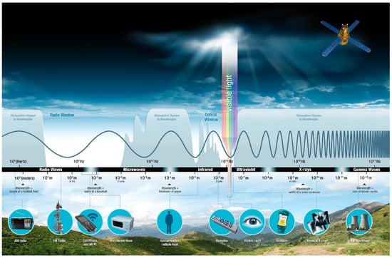
Figure 1.
Electromagnetic spectrum (https://smd-prod.s3.amazonaws.com/science-red/s3fs-public/thumbnails/image/EMS-Introduction.jpeg, accessed on 20 November 2022).
In RS, two categories of sensors are used—active sensors and passive sensors. The difference between them is that active sensors emit radiation to make their measurements, while passive sensors use existing radiation from the sun to make their own measurements. Passive sensors include radiometers, spectroscopic cameras, photographic radiometers, spectrometers, and spectroradiometers. Additionally, active sensors include RADAR (radio detection and ranging), scatterometer, and LiDAR. Certainly, each sensor provides different results in the archaeological context, with significant advantages and disadvantages. An important disadvantage of passive sensors is the impossibility of correct measurement during the night, but also on cloudy days, while in active sensors the disadvantages are focused on the fact that the emitted radiation can be affected by other radiations, and the geometric resolution is very low. The signals do not include clear spectral features, and complex analysis is required, which incurs costs. Regarding the advantages of an active ground sensor, we can cite, as an example, the ground penetrating radar (GPR), which can penetrate the ground surface, providing three-dimensional information about underground anomalies. An advantage of passive sensors, such as optical satellite sensors or ground spectroradiometers, is their ability to detect spectral anomalies, at different wavelengths, of the ground surface, such as crop marks. These spectral anomalies are used as receptors to detect buried archaeological remains [14]. It was observed that each object has a different interaction with electromagnetic radiation, which leads to distinguishing the objects from each other. This distinction is called the spectral signature of the object (Figure 2).
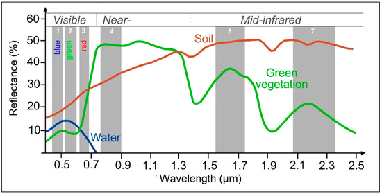
Figure 2.
Example of spectral response patterns of water, soil, and green vegetation (https://seos-project.eu/classification/classification-c01-p05.html, accessed on 20 November 2022).
Measurements can be made with a variety of instruments, including a spectrometer, although the most common is the separation of the red, green, blue, and near-infrared part of the spectrum of electromagnetic radiation, as acquired by digital cameras. This spectral information can be combined to give us some indicators. Indicators are various algorithms developed by researchers to improve the results (such as identification of archaeological remains) associated with an image. In many applications of vegetation monitoring using satellite remote sensing, vegetation indices are based mainly on simple combinations of visible and infrared information. Examples of a vegetation index used in the case of Agapiou and Sarris [14] is presented in Table 1 below.

Table 1.
Example of multispectral vegetation indices used in the study of Agapiou and Sarris in 2018 [14].
RS outperforms data collection and analysis with the advantages of the speed with which information is collected, as well as the possibility to compare information between different reception areas. In addition, there is the possibility of multiple measurements of an object, at different times, giving us the possibility, in this way, to collect and study its different characteristics. Another advantage of RS is the fact that we can pick up information that is not visible to the naked eye, such as receiving different wavelengths of electromagnetic radiation.
Many researchers have previously been involved in using remote sensing to locate underground remains. Even though the first aerial photography took place in the mid-19th century, it was only after the end of World War II that a more systematic use of RS in archeology began [18]. This period is considered an important milestone in the development of RS in archaeology, as researchers focused on areas where aerial photographs have been taken during the war, exploring new areas in both the Middle and Far East as well as Europe and the Americas.
The 1970s are marked by the launch of new satellite systems (US Landsat space program—1972) and, consequently, the development of recording receivers, while the 1980s that followed are characterized by the development of multispectral, thermal receivers, and radar images. In the last decades, and especially after 1999, a milestone was achieved due to the launch of the first high-resolution satellite sensor IKONOS. Archaeological research using RS gained more motivation for a more systematic exploitation of geospatial data. The development in the last 20 years of remote sensing has given great incentives to researchers to investigate new possibilities in archaeological research [14,17,19,20,21,22,23,24,25,26,27,28,29,30,31,32,33,34,35], such as the identification of leveled archaeological mounds using satellite remote sensing analyses [20] or using LiDAR data for the recognition of archaeological features [21,23]. Moving further with the integration of multispectral, and especially thermal images, a qualitative increase was achieved in the detection of ceramics given the difference in thermal signatures between vessels, stones, soil, and vegetation [36,37,38,39]. Aqdus et al. [36] have demonstrated the efficacy of multi-spectral and hyperspectral imagery in the identification of archaeological cropmarks, regardless of differences in terrain. Further cases proved that areas not accessible to archaeological excavation can be investigated thanks to the use of multispectral aerial photography at different times of the year [38].
Archaeological remote sensing already has a long history of research in scientific publications and applications in the field, as seen in many articles [6]. Several advantages emerge from the results of the research, which are not limited to the estimation of the parameters and properties of the surface/subsoil or the non-direct contact or destruction with the object of study.
Satellite visual images can be an objective source of information for heritage condition assessment, can be relatively inexpensive solution for large landscape areas compared to using a team of surveyors, and data collection can be easy and fast [20]. In addition, there is the ability to run iterative data analysis workflows for monitoring and condition assessment purposes (e.g., multi-temporal change detection). Although archaeologists rely on satellite pictures, airborne optical remote sensing is another important source of information, especially for archaeological reconnaissance, prospection, and landscape archaeology. Airborne data are valuable in areas where the archaeology landscape has changed dramatically because of human activity, such as urbanization and agricultural production [32]. Other remote sensing methods, such as LiDAR, use lasers with a much lower wavelength presenting better accuracy, which allows for the detection, visualization, and understanding of cultural heritage sites in more detail. LiDAR can perceive subtle depressions and patterns in the landscape uncoupled from photometric representations leading to discoveries such as Mayan caves [15]. Currently, the most used solution for cultural heritage in the field of close range and low altitude acquisitions are UAVs. Areas not accessible to archaeological excavation have been investigated thanks to the use of multispectral aerial photography during different times of the year, as well as by many different types of features, such as possible buried structures, traces of canals, and channels or paths. Even recent traces of vehicles can be detected [35].
In recent years, publications on remote sensing applications for archeology have proliferated mainly due to the development of all the above new technologies that give many advantages to researchers. This development is clearer in research articles written these last two decades, as presented in Figure 3 below.
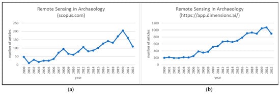
Figure 3.
Annual publications of Remote Sensing in Archaeology since 2000 (a) source: Scopus.com (accessed on 15 October 2022), (b) source: https://www.dimensions.ai (accessed on 10 November 2022).
The analysis was based on research conducted during October 2022 on Scopus.com (one of the largest abstract and citation database) and during November 2022 on www.dimensions.ai (a comprehensive research grants database, which links grants to millions of resulting publications, clinical trials, and patents).
In the Scopus engine database, the search was based on TITLE-ABS-KEY (remote AND sensing AND “archaeol*” OR “archeol*”) AND PUBYEAR > 1999. The results were articles from 2000 to the present. Regarding the search on Dimensions.ai, the keywords “remote sensing” AND “archaeol*” OR “archeol*” were used, and the results were limited to articles from 2000 to the present, and the search category was set to “Archaeology” and “History, Heritage and Archaeology”. As we can observe, there is a similarity in the trend of publications with little difference in their number, but both charts show a steep increase of publications, as well as a peak in one case in 2020 and in 2021 in the other.
However, the trend may be different when adding some other search engines or databases, as well as when setting other limitations such as publication types and access.
One explanation for the large number of publications in 2020 and 2021 could be the emergence of the COVID-19 pandemic [39]. During the period from 2020 to 2021, due to the long periods of lockdowns, many surveys in the field were cancelled. As a result, archaeologists and many other scientists had more time to analyze the data of past times, redefine existing data, confirm hypotheses based on remote sensing images [40], and prepare new publications. Additionally, archaeologists had the opportunity to explore new tools aimed at improving digital documentation workflows and preparing better for future work back in the field [41].
Recent studies [42] report a steady increase in applications in the literature aimed at this utilization of earth observation data, both from optical and active space-based sensors. The exploitation of satellite data and products are part of the applications of RS in archeology and cultural heritage to detect buried archaeological remains [43], as well for the study of the temporal evolution and changes of the archaeological site [44]. This also applied to monitoring archaeological sites and monuments against natural and man-made hazards [45,46].
The technology of remote sensing, and especially satellite Earth observation, although not originally designed and established for archaeological purposes, has become a very useful tool in archaeological and cultural heritage (ACH) and is being applied for various uses [47,48]. The existing spaceborne remote sensing tools in ACH generally can be divided into three types, based on the imaging techniques used—multispectral [35,49,50,51,52,53,54,55,56,57,58], hyperspectral [36,37,38,55,59,60], and synthetic aperture radar (SAR) [61,62,63,64,65,66]. Basic principles, as well as methods that make different remote sensing techniques suitable for ACH and produce some successful results, have been published and pointed out in many recent reviews [47,67,68,69]. For instance, in 2008, an archaeological site was identified in northeastern Thailand using airborne synthetic aperture radar (SAR) [70]. A few years later back, in 2011, in the case study of Alexakis et al. [44], satellite remote sensing was used to investigate the capability of space and aerial sensors and image processing techniques in the detection of neolithic settlements in Thessaly. Gade et al., six years later [71], referred to the detection of various kinds of remains of historical land use at high precision by using a very high-resolution acquisition (“staring spotlight”) mode of the TerraSAR/TanDEM-X satellites. Another work from 2020 was contributed to critically compare two types of fine-scale remotely sensed data: LiDAR and UAV–photogrammetric data [72]. In this work [72], the approaches that were applied to the remotely sensed data successfully revealed various archaeological remains within the study site that were presented.
Any proposed workflow should be customized based on the research questions and goals of the project, as in any sort of automation. As Traviglia and Torsello have referred to in 2017 [73], the design of a process that is used to extract specific objects, such as archaeological remains, must start from the landscape characteristics (including the morphology) and the nature, forms, model, and patterning of the system components.
3.2. Remote Sensing Platforms
Remote sensing platforms refer to structures or vehicles on which remote sensing instruments are mounted. The platform on which a particular sensor is installed determines several characteristics related to the use of sensors. The characteristics are the distance of the sensor from the object of interest, the periodicity of image acquisition, the time of image acquisition, the location, and the extent of coverage. One of the fields in which remote sensing from high points was used for the first time is ACH, which continued with kites and balloons. The evolution of RS continued with the use of aircraft and helicopters, UAVs (commonly known as drones), and, finally, satellites. Spatial resolution and viewing area decrease as platform height increases. Thus, the higher the sensor is placed, the lower the spatial resolution. The types or features of the platform depend on the type of sensor to be attached and its application. More specifically, remote sensing platforms can be on the ground, on an aircraft or balloon (within the Earth’s atmosphere), or on a satellite outside the Earth’s atmosphere (Figure 4).
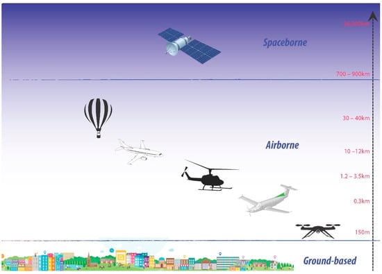
Figure 4.
Categories of remote sensing platforms.
Based on the height level of RS platforms, there are three types of platforms which have been rarely or widely applied to archaeological research: ground-based, airborne, and satellite. Airborne remote sensing, compared to satellite remote sensing, has the advantage or capability of offering very high spatial resolution images (20 cm or less). Below is a brief description of these different types.
3.2.1. Ground-Borne Platforms
In RS ground-based platforms sensors (Figure 5), handheld devices or tripods can be placed on a ladder, scaffolding, tall building, crane etc. These types of sensors are close to the ground and are used to record detailed information about the surface, or for close range characterization of objects. These types of platforms have the advantage of being relatively inexpensive, stable, and, due to their low altitude, they provide high-resolution data.
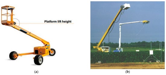
Figure 5.
(a,b) Ground-borne platforms (source: https://www.brainkart.com/article/Remote-sensing-platform_41126/, accessed on 14 October 2022 and https://weather.msfc.nasa.gov/landprocess/lp_gbe.html, accessed on 4 November 2022.
3.2.2. Air-Borne Platforms
Airborne platforms have been used to collect very detailed images and to facilitate the collection of data over virtually any time and on any portion of the Earth’s surface. Airborne platforms are structures or vehicles on which remote sensing instruments are mounted, looking downward or sideward, and can provide up to 50 km of elevated remote sensing data. The platform on which the sensor resides determines several characteristics, such as the distance of the sensor from the object of interest, image acquisition periodicity, image acquisition time, location, and extent of coverage. Airborne platforms were the sole non-ground-based platforms for early remote sensing work. Airborne platforms include unmanned aerial systems (UAS), free-floating balloons, airplanes, helicopters, and high-altitude aircraft. Aircrafts are classified into three types: (a) low altitude aerial remote sensing, (b) medium altitude aerial remote sensing, and (c) high altitude aerial remote sensing. Generally, airborne platforms are used to acquire aerial photographs for photo interpretation and photogrammetric purposes.
The use of UAS is growing rapidly and is used in a wide range of applications, including archaeology. UAS is an aircraft without an onboard pilot that is operated autonomously or manually by a remote-control operator and includes UAV, unmanned aircraft systems/vehicles, remotely piloted aircraft (RPA), and drones, which are used for a variety of purposes, including archaeology.
Drones were designed as a form of military reconnaissance and were developed during World War II in Britain, playing the role of a sky spy. Nowadays they play an important role in remote sensing. A drone is a tiny remote-controlled aircraft, including photography, infrared detection, radar observation, and television surveillance equipment. It uses a satellite communication link while an onboard computer stores data from different sensors and instruments. There are four main physical types of professional drones: multi-rotor, fixed-wing, single-rotor helicopters, and fixed-wing hybrid VTOLs (Figure 6). A significant advantage is that it can be accurately positioned over the area of interest—within a few centimetres—and capable of providing both night and day data.
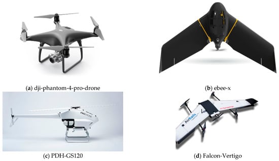
Figure 6.
(a) multi-rotor https://www.stickpng.com/img/electronics/dji-drones/dji-phantom-4-pro-drone (accessed on 17 October 2022), (b) fixed-wing https://www.sensefly.com/drones/ebee-x/ (accessed on 17 October 2022), (c) single-rotor helicopterhttps://www.prodrone.com/products/pdh-gs120/ (accessed on 16 October 2022) and (d) fixed-wing hybrid VTOL https://www.uasvision.com/wp-content/uploads/2017/02/Falcon-Vertigo.png (accessed on 17 October 2022).
Balloons have been used in remote sensing observation (aerial photography), as well in nature conservation studies, but today are rarely used because they are not very stable, and the course of flight is not always predictable. Balloons float at a constant height of about 30 km and are governed by the wind. The first aerial photograph was taken by French author and artist Felix Tournachon. The flight was over the Bievre Valley in 1858, and Felix Tournachon, with the alias Nadar, captured the first aerial photo from a tethered balloon (Figure 7).
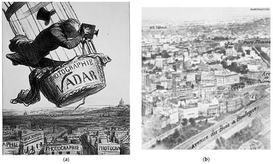
Figure 7.
(a) Daumier, Nadar elevating photography to the level of art (1862) (b) Nadar early aerial photograph of Paris c 1860 (source: The adventures of Nadar photography, ballooning, invention and the impressionists by Philip McCouat).
Aircraft platforms (Figure 8) are medium/high altitude aerial remote sensing platforms, offering an economical method of remote sensing data collection covering small to large study areas using cameras, electronic imagers, across-track and along-track scanners, and radar and microwave scanners. Special aircraft with cameras and sensors on vibration-less platforms are traditionally used to acquire aerial photographs and images of land surface features. Low altitude aerial photography results in large scale images providing detailed information on the terrain. In contrast, the high-altitude smaller scale images provide advantage covering a larger study area but with low spatial resolution.

Figure 8.
ADAM, aircraft platform (source: https://www.joanneum.at/en/digital/productssolutions/adam, (accessed on 4 November 2022).
3.2.3. Space-Based Platforms
In space RS, sensors are placed on a space shuttle or satellite which orbit around the Earth. The altitude of space imaging ranges from 250 km to 36,000 km. Satellites (examples of commonly known satellite sensors specifications are presented in Table 2) move freely in their orbit, around the whole earth or any part of the earth with the ability to cover areas at fixed intervals. Coverage mainly depends on the satellite’s orbit. Through these space platforms, a huge amount of remote sensing data is captured. Advantages provided by space remote sensing are: (a) the ability to cover a large area; (b) frequent and repeated coverage of an area of interest; and (c) the use of radiometrically calibrated sensors to quantitatively measure soil characteristics.
Table 2.
Technical specifications of commonly known satellite sensors.
4. Artificial Intelligence in Archaeology
AI, due to its increasingly powerful predictive capabilities, is showing an increasing trend in attracting widespread interest in many sciences. Archaeologists now can more fully exploit the knowledge from an extensive amount of archaeological data with the use of artificial intelligence [74,75,76,77,78,79,80,81,82,83,84,85,86,87,88,89,90,91,92,93,94,95,96,97,98,99] in such a way as to make decisions related to appropriate strategies for the preservation and protection of archaeological elements, as well as to decide on the most ideal point excavation in a complex cultural landscape. A variety of studies have concluded that, with artificial intelligence, archaeologists can avoid a costly or even time-consuming process for research and excavation in limited archaeological areas. For instance, the overall findings of Agapiou et al. [75], along with those published by Orengo and Garcia-Molsosa [1], showcase that using DL in UAV imageries can be revolutionary in the field of archaeological field research, having great potential to support future archaeological field projects. It is cost-effective, especially in cases where there is a limited research time frame. These case studies also demonstrate the ability to provide faster results and higher analytical capabilities when applied under favorable conditions. Future advances in computer vision and machine learning have the potential to fundamentally reshape the ability of archaeological research to deal with massive data covering large areas, minimizing the reliance on human resources. Berganzo-Besga et al. [86] recently, in 2021, introduced, for the first time, an improved AI algorithm for large-scale automatic detection of archaeological tombs, which are a common type of archaeological structure, by using LiDAR and multispectral satellite data. The results of the survey are a valid alternative to the manual detection of these types of archaeological remains [86].
4.1. Key Components of AI
Jamil et al. [100], in recent research (in the beginning of 2022), refer to, that, in the archaeology field, most of the ML and DL algorithms are used for classification and identification of artifacts. But, in contrast, detection of archaeological data using DL is still insufficient. The main elements of the AI that is used in archaeology can be seen in Figure 9 below.
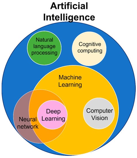
Figure 9.
Key Components of AI.
- Machine learning: allows software applications to become more accurate at predicting outcomes without the requirement for explicit programming.
- Deep learning: a subset of ML that learns by processing data based on artificial neural networks with representation learning.
- Neural network: NN mimics the way the human brain operates with a series of algorithms that endeavors to recognize underlying relationships in a set of data.
- Natural language processing (NLP) is a subfield of computer science and artificial intelligence concerned with the recognition, interpretation, and production of human language and speech.
- Computer vision: a subset of machine learning and pattern identification that enables computers to interpret image content based on graphs, tables, PDF pictures, and videos.
- Cognitive computing: this is related to technology platforms that attempt to mimic the way a human brain works.
4.2. Applications of AI and Remote Sensing for Archaeological Research
Applications of AI and remote sensing for archaeological research is still in its beginning, as this is illustrated in the literature research that was applied.
In this review of AI and RS for archaeological research, two focus areas were predetermined, which are RS for archaeological research, as referred to in Section 3.1 above, and AI for archaeological research. This second search was also conducted using the Scopus engine database and the Dimensions engine during the same period that the remote sensing search took place, as referred above. The search was based on TITLE-ABS-KEY (artificial AND intelligence AND “archaeol*” OR “archeol*”) AND PUBYEAR > 1999. The results were again only from 2000 and onwards. Regarding the search on Dimensions, the keyword “artificial intelligence AND “archaeol*” OR “archeol*” was used, and the results were again limited to articles from 2000 to the present, and the search category was set to “Archaeology” and “History, Heritage and Archaeology”.
Results show a general trend of fluctuating publications (Figure 10), while the number of papers between the two searches related to artificial intelligence in archeology differs. More specifically, in the Scopus survey of 2020, there appears a peak of publications in contrast to the Dimensions survey, where the publications are quite high, but not as significant as in 2018 or the current year (2022).
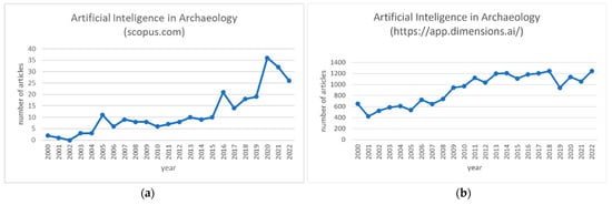
Figure 10.
Annual publications of artificial intelligence in archaeology since 2000 (a) source: Scopus.com, (accessed on 15 October 2022), (b) source: https://www.dimensions.ai (accessed on 10 November 2022).
This can be the result of an ongoing debate about the appropriateness of AI methods in archaeological practice, but it can also be another effect of the COVID-19 pandemic, as we mentioned above. Another reason can be the disagreement of researchers about the definitions that researchers emphasize. Thus, a complex phenomenon might turn into simple phrases that end up being even more complex than the phenomena they intend to define [83]. One question is whether we ultimately need AI and to what extent. Is an AI ultimately smarter than it really is, or is it smarter that is believed to be? Do these models make errors and, if so, what kinds of errors? Are these errors similar or different from humans’ errors? All these questions lead to the concept of the so-called barrier of meaning [101]. With this term, we want to highlight the gap that exists between the knowledge of the expert and the knowledge captured by the machine. In other words, this represents the gap between the actual process we are trying to automate with an AI and its final approximation. Therefore, in the process of designing an AI-based system, we must not forget the existence of this gap. Nevertheless, as shown by various recent archaeological studies, when we have a very well-designed model, the results can provide consistency, high accuracy, and an estimate of probability in the identification of archaeological remains without any automated detection replacing human experts [102].
Sharafi et al., in their 2016 paper [103], provided clear evidence that pattern recognition has real potential as an effective application of artificial intelligence to locate archaeological burials. In addition, it is believed that the expensive and time-consuming efforts of surveying and excavating landscape areas that present a limited extent of archaeological content can be avoided by archaeologists. In the field of archaeology, as reported by Jamil et al. [98], there has been a growing trend in recent years to use artificial intelligence algorithms, such as ML and DL, for artifact classification and recognition. However, in the same paper, it is mentioned that the research on the detection of archaeological structures, especially those applying the DL algorithm or using aerial imaging, is still insufficient.
Below are presented five examples of publications from recent years, and especially 2020, from research applications of AI to locate archaeological remains using drone and satellite images.
Orengo and Garcia-Molsosa, back in 2019 [1], published an article related to automated ML-based potsherd detection using high-resolution drone imagery. The results of this paper show that the potential of this technique, if applied under appropriate field circumstances, can produce accurate distribution maps of individual potsherds providing new potentials of archaeological survey. The workflow combined drone photogrammetry and ML to automatically record surface distributions of archaeological material. As a result, it provided faster results and higher analytical capabilities under favorable conditions compared to a traditional pedestrian survey.
In 2020, Mehrnoush et al. [104] published an article for research applying CNN based deep learning model to detect a qanat shaft using Cold War-era CORONA satellite images. This was a first attempt of utilizing automated detection on historical satellite images for automated qanat shaft detection. Data collection, data pre-processing, model construction, and model assessment were included in the ML pipeline. For model training, images with both low and high density of qanat features were included. The results obtained showed an overall precision and recall for the model of 0.62 and 0.74, respectively.
In the same year (2020), Bundzel et al. [105] applied a semantic segmentation of airborne LiDAR data to Maya archaeology. Two deep learning-based models for semantic segmentation, U-Net and Mask R-CNN, were built and compared with each other. These two segmentation models were used in two tasks: first, to identify areas of ancient construction activity and, second, to identify the remains of ancient Maya buildings. The research results showed that the model based on U-Net performed better on both tasks and had a recognition rate for all items between 60 and 66%.
Another example of AI was presented in 2020 by Orengo et al. [106], which was related to an automated detection approach for archaeological mounds. That work presented an innovative multi-sensor, multi-temporal machine learning approach using large RS data to detect archaeological mounds in Cholistan (Pakistan). In this research, the Google Earth Engine was used, in which a classifier algorithm was implemented that used multispectral images and a collection of large-scale synthetic aperture radars. The result covered a range of approx. 36,000 km2, in which many more archaeological mounds emerged than previously recorded, giving other possibilities for understanding the area from an archaeological point of view. The signature classification process involved (a) collecting training data, (b) training the classifier model, (c) classifying the image composition, and, finally, (d) validating the classifier with an independent validation set. All previously known mounds in the study area were detected using a ML algorithm, and, in addition, accurate locations and many new mounds were gathered, far exceeding the expectations set by previous research.
Recently, in 2021, Berganzo-Besga et al. [86] introduced, for the first time, an improved AI algorithm for large-scale automatic detection of archaeological tombs, which are a common type of archaeological structure, using LiDAR and multispectral satellite data. The results of the survey are a valid alternative to the manual detection of this type of archaeological remain. This research combined machine learning techniques (random forest) for terrain classification using multi-temporal multispectral Sentinel-2 data, as well as a DL model on LiDAR data, previously pre-processed using a multi-scale terrain model. The algorithm used was an improved version of a previous attempt, with a detection rate of 89.5%, an average accuracy of 66.75%, and a precision of 0.97. As a result, 10,527 burial tumuli over an area of about 30,000 km2 were identified. This approach is the largest that has been applied so far from a small training data set. This method can be used wherever LiDAR data or high-resolution digital terrain models are available, since the code and platforms used to develop the algorithm are open source.
A recent study, combining DL and traditional ML, was published by Davis et al. in 2021 [107]. What researchers showed was that both deep learning and automation can be used to detect new archaeological features, but also to systematically estimate the spatial extents of certain archaeological buildings. Specifically, this study used a multidimensional procedural workflow to detect shell rings. Using multiple data sources, such as LiDAR, SAR, multispectral, and new analytical methods, researchers have identified over 100 extant shell rings throughout South Carolina. A further quantification of the geographical extent of this building tradition showed that many of these features are quite small compared to known examples, suggesting that not all shell rings were used as monumental centers. The DL model, as well as all the code used for the above analysis, is open source, with the main goal for future researchers being that of using it and improve the results.
Further important findings, together with those published by Agapiou et al. [75], following the work of [1], show that low-altitude remote sensing sensors (e.g., UAVs) can provide significant outcomes. Following these cases, a simulation study was recently (May 2022) implemented by authors in Cyprus, aiming to adopt low-altitude multispectral and RGB cameras to investigate whether a semi-automated methodology for recording potsherds could be developed to answer research questions for a more efficient approach in terms of time and accuracy compared to traditional fieldwalking archaeological surveys.
ML algorithms, such as random forest (RF) classifiers, have been implemented and compared along with the results from foot surveys. Utilizing workflow of [1] in our study, the overall accuracy and relative accuracy were estimated (average accuracy around 90%). The preliminary results (Figure 11) were compared with the archaeological surface survey records, showing that semi-automatic detection methods using low-altitude remote sensing sensors can be used as a first proxy indicator for the detection of surface archaeological ceramics.
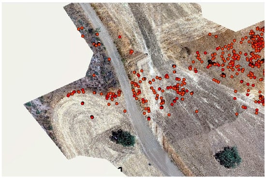
Figure 11.
Preliminary results of surface archaeological ceramics using semi-automatic detection methods and low-altitude remote sensing sensors (Red dots indicate positive detections classified as ceramics after the implementation of RF classifier).
These results and accuracy were very promising but can vary, depending on a variety of factors, such as the type of soil, the conditions of the plot, the period of flight, the visibility, the type of crops, and the quantity of the material culture, but also the number and experience of the inspectors. Certainly, in the future, further improvements can be made and more sophisticated remote sensing algorithms will be used to cover even larger areas with a higher success rate.
5. Discussion
Archeology has evolved into many new subfields, such as historical archaeology, RS archaeology, environmental archeology, and other interdisciplinary approaches due to the great and rapid development of science and technology, and especially the combination of applications in the natural sciences and the humanities and the social sciences.
RS shows an increasing trend of interest from experts as well as the public, as there is the possibility to combine three basic substances of archaeological research: objects, space, and time [108]. It is an important tool, enabling archaeologists to search for and understand ACH sites, as well as to discover and to monitor archaeological sites, but also to solve real archaeological problems, such as documenting and preserving cultural heritage. The subject of study is, of course, also the ACH feature that is buried underground or, sometimes, surface debris. Whether archaeological remains are underground or on the surface, remote sensing archeology applies knowledge of its properties to “space”, including micro-space (site scale) and macro-space (landscape scale) and, in combination with AI approaches which are increasingly employed, new knowledge for archaeological data is created.
As Barder has referred in 2011 [109], archaeology was one of the first disciplines to use remote sensing in scientific investigations. As soon as it became apparent that excavations and traditional surveys alone did not provide sufficient clues for understanding the various aspects of past settlements and their transformation over time, ‘auxiliary’ approaches, such as AI, ML, and DL, were brought in. Back in 2018, Hutson [110] made a detailed critique of the widespread use of AI, but with little understanding of when and why AI works well or when and why it might work less well. AI in recent years has attracted more and more interest in many sciences. More specifically, in the case of archaeologists, it enables them to take full advantage of the knowledge that emerges from a wide range of archaeological data while at the same time helping them to make decisions related to appropriate strategies in relation to conservation and protection as to where it is best to excavate in a complex cultural landscape.
Nevertheless, AI approaches cannot be considered as a panacea for archaeological research. While AI potentials are obvious, such as automation and high accuracy, AI methodologies still have some major limitations to overcome. The first limitation regards the large number of samples that are needed to be collected for training, calibration, and validation purposes of the AI models. In some cases, a large and representative number of samples is limited, and, therefore, this prohibits the training performance of the AI model. In addition, accuracy assessment of the AI models is usually performed using samples taken within the same “context” and archaeological area. Therefore, AI accuracy is not directly linked with the given complexity of archaeological sites and the heterogeneity that we can observe in real archaeological surveys (i.e., multi-diachronically occupations of a site, variety of ceramic typology, etc). Sometimes, the sample itself is provided (or only available) for only a few types of archaeological objects and functions of archaeological sites, which makes it difficult for the AI algorithm to understand, and therefore detect, other features that fall beyond a certain period, typology, etc. Lastly, it should be mentioned that most of the AI approaches carried out in the past are driven by examples from the northern hemisphere, in contrast with the limited rate of examples from the southern hemisphere. These limitations need to be turned into challenges, and then into opportunities, for the AI applications in the domain of remote sensing archaeology.
With AI in its current state, one question that can be answered is whether it is possible for algorithms to oversimplify the detection problem and generally be able to approach or exceed human performance for complex object detection tasks in different environments. A workflow in the case of [87] was developed to answer a related question. A large, random test data set—next to a small, non-random data set—was developed, which better represents the real situation of rare archaeological objects in different types of complex terrain. The result of the research showed that the methodology was not intended to either overcome or replace archaeological experts. Instead, artifact detection models are intended to become another instrument in the archaeologist’s toolbox that aid rapid and systematic mapping of objects of interest over extended areas in large and complex data sets. With the reduction in detection time, the expert’s time can be reallocated to the analysis, validation (level), and interpretation of the results.
Through this literature review, we observed that the combination of RS with AI can ensure that archaeologists avoid the costly and time-consuming efforts of surveying and excavating more archaeologically restricted landscape areas. It is now outdated to focus on whether archeology should embrace automated detection. Instead, the aim should be to answer how to embrace AI tools to overcome the challenges of data overload and how to accelerate the RS documentation process in the face of the increasingly rapid destruction of the archaeological site landscapes. Automation does not replace human experts, but it will open new research opportunities that are not currently possible. For example, a regional-scale comparative study of qanat technology was currently impossible because no one had the time to create detailed maps of qanat axes by hand. A first attempt to use automated techniques on historic satellite imagery that takes advantage of neither the spectral imagery resolution, nor very high (sub-meter) spatial resolution, demonstrated that deep learning, even with small datasets, can be successfully applied to automate the detection of qanat shafts [104]. It is worth pointing out that achieving increased success rates not only requires a better understanding of how and why AI applications works, but it is necessary to clarify the basis by which archaeologists locate and classify archaeological monuments and remains.
Ultimately, many will be wondering how the future of AI and other automation techniques within RS archaeology will be and if is there anything more that can be offered beyond data collection. We can soon envision the use of RS platforms with more sophisticated sensors, which will be able to detect archaeological remains with higher accuracy within less time. Archaeologists might be able to use more intelligent automations to collect samples without disturbing the condition of the archaeological remains. Additionally, climate changes, such as temperature increases, as well as changes in moisture cycles, continue increasing dramatically, and will inevitably be expected to contribute to an increase impact on the archaeological heritage (both to known or still buried) [111]. As Burke et al. [112] have communicated, the increasing availability of high-resolution climatological and ecological reconstructions allows us to study the effects of past climate change at a human scale, which correlates with archaeological data and allows the reconstruction of past adaptive responses to specific types of environmental impacts, including sea level change, rapid cooling and warming, climate instability, and prolonged drought. The use of archaeological models to predict impacts of a future climate change on modern societies is a relatively new concept that attempts to bridge established theories in the social and natural sciences and is based on the recognition of the value of adopting a long-term perspective for climate change research. Perhaps we should expect, in the future, a higher contribution of AI to climate change risk assessment, at least in studies that have been conducted for specific cultural heritage monuments.
Therefore, with continued technological progress of RS and AI and the integration of skills, aims, and experiences, it seems potential that archeology will soon become an advanced technological science.
Author Contributions
Conceptualization, methodology, A.A. (Argyro Argyrou), A.A. (Athos Agapiou); writing—original draft preparation, A.A. (Argyro Argyrou); writing—review and editing, A.A. (Athos Agapiou); supervision, A.A. (Athos Agapiou). All authors have read and agreed to the published version of the manuscript.
Funding
This research was funded by the ENSURE project (innovative survey techniques for detection of surface and sub-surface archaeological remains), a Cyprus University of Technology internal funding.
Data Availability Statement
Not applicable.
Acknowledgments
The authors acknowledge the ENSURE project (innovative survey techniques for detection of surface and sub-surface archaeological remains) and CUT internal funding. This review paper is part of the PhD dissertation of A. Argyrou, supervised by the A. Agapiou. The authors would like to thank the three anonymous reviewers for their criticism, and suggestions for improvements during the review process.
Conflicts of Interest
The authors declare no conflict of interest. The funders had no role in the design of the study; in the collection, analyses, or interpretation of data; in the writing of the manuscript; or in the decision to publish the results.
References
- Orengo, H.A.; Garcia-Molsosa, A. A brave new world for archaeological survey: Automated machine learning-based potsherd detection using high-resolution drone imagery. J. Archaeol. Sci. 2019, 112, 105013. [Google Scholar] [CrossRef]
- Renfrew, C.; Bahn, P. Chapter 2, What is Left? The Variety of the Evidence. In Archaeology, Theories, Methods and Practice; Thames and Hudson Ltd.: London, UK, 1991. [Google Scholar]
- Alcock, S.E.; Cherry, J.F. Introduction. In Side-By-Side Survey. Comparative Regional Studies in the Mediterranean World; Alcock, S.E., Cherry, J.F., Eds.; Oxbow Books: Oxford, UK, 2004; pp. 1–9. [Google Scholar]
- De Laet, V.; Paulissen, E.; Waelkens, M. Methods for the extraction of archaeological features from very high-resolution Ikonos-2 remote sensing imagery, Hisar (southwest Turkey). J. Archaeol. Sci. 2007, 34, 830–841. [Google Scholar] [CrossRef]
- Barone, P.M.; Wueste, E.; Hodges, R. Remote Sensing Materials for a Preliminary Archaeological Evaluation of the Giove Countryside (Terni, Italy). Remote Sens. 2020, 12, 2023. [Google Scholar] [CrossRef]
- Tapete, D. Remote Sensing and Geosciences for Archaeology. Geosciences 2018, 8, 41. [Google Scholar] [CrossRef]
- Lasaponara, R.; Masini, N. Satellite remote sensing in archaeology: Past, present and future perspectives. J. Archaeol. Sci. 2011, 38, 1995–2002. [Google Scholar] [CrossRef]
- Materazzi, F.; Pacifici, M. Archaeological crop marks detection through drone multispectral remote sensing and vegetation indices: A new approach tested on the Italian pre-Roman city of Veii. J. Archaeol. Sci. Rep. 2022, 41, 103235. [Google Scholar] [CrossRef]
- Czajlik, Z.; Črešnar, M.; Doneus, M.; Fera, M.; Kramberger, A.H.; Mele, M. Researching archaeological landscapes across borders Strategies, methods and decisions for the 21st century Graz—Budapest, 2019. Diss. Archaeol. 2020, pp. 299–301. Available online: https://www.academia.edu/40373820 (accessed on 29 August 2022).
- Hadjimitsis, D.G.; Agapiou, A.; Themistocleous, K.; Alexakis, D.D.; Sarris, A. Remote Sensing for Archaeological Applications: Management, Documentation and Monitoring. Remote Sens. Environ. Integr. Approaches 2013, 2013, 57–95. [Google Scholar] [CrossRef]
- Fountas, S.; Gemtos, T. Γεωργία Aκριβείας [Undergraduate Textbook; Kallipos, Open Academic Editions: Athens, Greece, 2015; Available online: http://hdl.handle.net/11419/2670 (accessed on 7 September 2022).
- Fischer, W.A.; Hemphill, W.R.; Kover, A. Progress in remote sensing (1972–1976). Photogrammetria 1976, 32, 33–72. [Google Scholar] [CrossRef]
- Davis, D.S.; Seeber, K.E.; Sanger, M.C. Addressing the problem of disappearing cultural landscapes in archaeological research using multi-scalar survey. J. Isl. Coast. Archaeol. 2021, 16, 524–540. [Google Scholar] [CrossRef]
- Agapiou, A.; Sarris, A. Beyond GIS Layering: Challenging the (Re)use and Fusion of Archaeological Prospection Data Based on Bayesian Neural Networks (BNN). Remote Sens. 2018, 10, 1762. [Google Scholar] [CrossRef]
- Gallwey, J.; Eyre, M.; Tonkins, M.; Coggan, J. Bringing lunar LiDAR back down to earth: Mapping our industrial heritage through deep transfer learning. Remote Sens. 2019, 11, 1994. [Google Scholar] [CrossRef]
- Campbell, J.B.; Wynne, R.H. Introduction to Remote Sensing, 5th ed.; The Guilford Press: New York, NY, USA, 2011. [Google Scholar]
- Davis, D.S. Geographic disparity in machine intelligence approaches for archaeological remote sensing research. Remote Sens. 2020, 12, 921. [Google Scholar] [CrossRef]
- Sarris, A.; Kokkinou, E.; Soupios, P.; Papadopoulos, E.; Trigas, V.; Sepsa, O.; Gionis, D.; Iakovou, M.; Agapiou, A.; Satraki, A.; et al. Geophysical investigations in Palaipafos, Cyprus, 36th Annual Conference on Computer Applications and Quantitative Methods in Archaeology, CAA, 2008 “On the Road to Reconstructing the Past”. Budapest 2008, in press. [Google Scholar]
- Bicker, S.H. Machine Learning Arrives in Archaeology. Camb. Univ. Press Behalf Soc. Am. Archaeol. 2021, 6, 186–191. [Google Scholar] [CrossRef]
- Bini, M.; Isola, I.; Zanchetta, G.; Ribolini, A.; Ciampalini, A.; Baneschi, I.; Mele, D.; D’Agata, A.L. Identification of leveled archeological mounds (Höyük) in the alluvial plain of the Ceyhan River (Southern Turkey) by satellite remote-sensing analyses. Remote Sens. 2018, 10, 241. [Google Scholar] [CrossRef]
- Davis, D.S.; Sanger, M.C.; Lipo, C.P. Automated mound detection using lidar and object-based image analysis in Beaufort County, South Carolina. Southeast. Archaeol. 2019, 38, 23–37. Available online: http://www.tandfonline.com/10.1080/0734578X.2018.1482186 (accessed on 30 August 2022). [CrossRef]
- Verschoof-van der Vaart, W.B.; Lambers, K. Applying automated object detection in archaeological practice: A case study from the southern Netherlands. Archaeol. Prospect. 2021, 29, 15–31. Available online: https://onlinelibrary.wiley.com/doi/epdf/10.1002/arp.1833 (accessed on 17 August 2022). [CrossRef]
- Albrecht, C.M.; Fisher, C.; Freitag, M.; Hamann, H.F.; Pankanti, S.; Pezzutti, F.; Rossi, F. Learning and Recognizing Archeological Features from LiDAR Data. In Proceedings of the 2019 IEEE International Conference on Big Data (Big Data), Los Angeles, CA, USA, 9–12 December 2019. [Google Scholar] [CrossRef]
- Orengo, H.A.; Garcia-Molsosa, A.; Berganzo-Besga, I.; Landauer, J.; Aliende, P.; Tres-Martínez, S. New developments in drone-based automated surface survey: Towards a functional and effective survey system. Archaeol. Prospect. 2021, 28, 519–526. [Google Scholar] [CrossRef]
- Snitker, G.; Moser, J.D.; Southerlin, B.; Stewart, C. Detecting historic tar kilns and tar production sites using high-resolution, aerial LiDAR-derived digital elevation models: Introducing the Tar KilnFeature Detection workflow (TKFD) using open-access R and FIJI software. J. Archaeol. Sci. Rep. 2022, 41, 103340. [Google Scholar] [CrossRef]
- Borie, C.; Parcero-Oubiña, C.; Kwon, Y.; Salazar, D.; Flores, C.; Olguín, L.; Andrade, P. Beyond site detection: The role of satellite remote sensing in analysing archaeological problems. A case study in Lithic Resource Procurement in the Atacama Desert, Northern Chile. Remote Sens. 2019, 11, 869. [Google Scholar] [CrossRef]
- Davis, D.S. Object-Based Image Analysis: A Review of Developments and Future Directions of Automated Feature Detection in Landscape Archaeology. Archaeol. Prospect. 2018, 26, 155–163. [Google Scholar] [CrossRef]
- Monna, F.; Magail, J.; Rolland, T.; Navarro, N.; Wilczek, J.; Gantulga, J.O.; Esin, Y.; Granjon, L.; Allard, A.C.; Chateau-Smith, C. Machine learning for rapid mapping of archaeological structures made of dry stones–Example of burial monuments from the Khirgisuur culture, Mongolia. J. Cult. Herit. 2020, 43, 118–128. [Google Scholar] [CrossRef]
- Thabeng, O.L.; Merlo, S.; Adam, E. High-Resolution Remote Sensing and Advanced Classification Techniques for the Prospection of Archaeological Sites’ Markers: The Case of Dung Deposits in the Shashi-Limpopo Confluence Area (Southern Africa). J. Archaeol. Sci. 2019, 102, 48–60. [Google Scholar] [CrossRef]
- Inomata, T.; Pinzón, F.; Ranchos, J.; Haraguchi, T.; Nasu, H.; Fernandez-Diaz, J.; Aoyama, K.; Yonenobu, H. Archaeological Application of Airborne LiDAR with Object-Based Vegetation Classification and Visualization Techniques at the Lowland Maya Site. Remote Sens. 2017, 9, 563. [Google Scholar] [CrossRef]
- Cowley, D.; Verhoeven, G.; Traviglia, A. Editorial for Special Issue: “Archaeological Remote Sensing in the 21st Century: (Re)Defining Practice and Theory”. Remote Sens. 2021, 13, 1431. [Google Scholar] [CrossRef]
- Luo, L.; Wang, X.; Guo, H.; Lasaponara, R.; Zong, X.; Masini, N.; Wang, G.; Shia, P.; Khatteli, H.; Chen, F.; et al. Airborne and spaceborne remote sensing for archaeological and cultural heritage applications: A review of the century (1907–2017). Remote Sens. Environ. 2019, 232, 111280. [Google Scholar] [CrossRef]
- Verhoeven, G.J. Are We There Yet? A Review and Assessment of Archaeological Passive Airborne Optical Imaging Approaches in the Light of Landscape Archaeology. Geosciences 2017, 7, 86. [Google Scholar] [CrossRef]
- Hritz, C. Tracing settlement patterns and channel systems in southern Mesopotamia using remote sensing. J. Field Archaeol. 2010, 35, 184–203. [Google Scholar] [CrossRef]
- Abate, N.; Frisetti, A.; Marazzi, F.; Masini, N.; Lasaponara, R. Multitemporal–Multispectral UAS Surveys for Archaeological Research: The Case Study of San Vincenzo Al Volturno (Molise, Italy). Remote Sens. 2021, 13, 2719. [Google Scholar] [CrossRef]
- Aqdus, S.A.; Hanson, W.S.; Drummond, J. The potential of hyperspectral and multi-spectral imagery to enhance ar-chaeological cropmark detection: A comparative study. J. Archaeol. Sci. 2012, 39, 1915–1924. [Google Scholar] [CrossRef]
- Abrams, M.; Comer, D. Multispectral and hyperspectral technology and archaeological applications. In Mapping Archaeological Landscapes from Space; Springer: New York, NY, USA, 2013; pp. 57–71. [Google Scholar] [CrossRef]
- Agapiou, A.; Hadjimitsis, D.G.; Sarris, A.; Georgopoulos, A.; Alexakis, D.D. Optimum temporal and spectral window for monitoring crop marks over archaeological remains in the Mediterranean region. J. Archaeol. Sci. 2013, 40, 1479–1492. [Google Scholar] [CrossRef]
- Geser, G. Impact of COVID-19 on Archaeology and Cultural Heritage. Salzburg Research 29 October 2021. Available online: https://ariadne-infrastructure.eu/wp-content/uploads/2021/11/COVID-19_impact-archaeology-and-cultural-heritage_29Oct2021.pdf (accessed on 20 August 2022).
- Fitton, T.; Wynne-Jones, S. Integrating legacy data for archaeological and remote survey at the 7–15th century site of Unguja Ukuu, Zanzibar. In Proceedings of the CAA 2021, Programme and Abstracts, Limassol, Cyprus (gone virtual), 14–18 June 2021; pp. 534–535. Available online: https://2021.caaconference.org/wpcontent/uploads/sites/28/2021/06/CAA2021_Detailed-Programme_16June.pdf (accessed on 1 September 2022).
- Budka, J. Archaeological Team Building in Times of COVID-19. Munich University Attab to Ferka Survey Project Blog. 20 July 2020. Available online: https://www.sudansurvey.gwi.unimuenchen.de/index.php/tag/digital-archaeology/ (accessed on 27 September 2022).
- Agapiou, A.; Lysandrou, V. Remote sensing archaeology: Tracking and mapping evolution in European scientific literature from 1999 to 2015. J. Archaeol. Sci. 2015, 4, 192–200. [Google Scholar] [CrossRef]
- Agapiou, A.; Alexakis, D.; Sarris, A.; Hadjimitsis, D.G. Evaluating the Potentials of Sentinel-2 for Archaeological Perspective. Remote Sens. 2014, 6, 2176–2194. [Google Scholar] [CrossRef]
- Alexakis, D.; Sarris, A.; Astaras, T.; Albanakis, K. Integrated GIS, remote sensing and geo-morphologic approaches for the reconstruction of the landscape habitation of Thessaly during the neolithic period. J. Archaeol. Sci. 2011, 38, 89–100. [Google Scholar] [CrossRef]
- Hadjimitsis, D.G.; Agapiou, A.; Alexakis, D.D.; Sarris, A. Exploring natural and anthropogenic risk for cultural heritage in Cyprus using remote sensing and GIS August 2011. Int. J. Digit. Earth 2013, 6, 115–142. [Google Scholar] [CrossRef]
- Hadjimitsis, D.G.; Themistocleous, K.; Agapiou, A.; Clayton, C.R.I. Multi-temporal study of archaeological sites in Cyprus using atmospheric corrected satellite remotely sensed data. Int. J. Archit. Comput. 2009, 7, 121–138. [Google Scholar] [CrossRef]
- Luo, L.; Wang, X.; Liu, J.; Guo, H.; Zong, X.; Ji, W.; Cao, H. VHR GeoEye-1 imagery reveals an ancient water landscape at the Longcheng site, northern Chaohu Lake Basin (China). Int. J. Digit. Earth 2016, 10, 139–154. [Google Scholar] [CrossRef]
- Brivio, P.A.; Pepe, M.; Tomasoni, R. Multispectral and multiscale remote sensing data for archaeological prospecting in an alpine alluvial plain. J. Cult. Herit. 2000, 1, 155–164. [Google Scholar] [CrossRef]
- Aminzadeh, B.; Samani, F. Identifying the boundaries of the historical site of Persepolis using remote sensing. Remote Sens. Environ. 2006, 102, 52–62. [Google Scholar] [CrossRef]
- Lasaponara, R.; Masini, N. Detection of archaeological crop marks by using satellite Quick Bird multispectral imagery. J. Archaeol. Sci. 2007, 34, 214–221. [Google Scholar] [CrossRef]
- Evans, D.; Pottier, C.; Fletcher, R.; Hensley, S.; Tapley, I.; Milne, A.; Barbetti, M. A comprehensive archaeological map of the world’s largest preindustrial settlement complex at Angkor, Cambodia. Proc. Natl. Acad. Sci. USA 2007, 104, 14277–14282. Available online: www.pnas.org/cgi/doi/10.1073pnas.0702525104 (accessed on 8 July 2022). [CrossRef]
- Garrison, T.G.; Houston, S.D.; Golden, C.; Inomata, T.; Nelson, Z.; Munson, J. Evaluating the use of IKONOS satellite imagery in lowland Maya settlement archaeology. J. Archaeol. Sci. 2008, 35, 2770–2777. [Google Scholar] [CrossRef]
- Alexakis, D.; Sarris, A.; Astaras, T.; Albanakis, K. Detection of Neolithic settlements in Thessaly (Greece) through multispectral and hyperspectral satellite imagery. Sensors 2009, 9, 1167–1187. [Google Scholar] [CrossRef] [PubMed]
- Rajani, M.B.; Rajawat, A.S. Potential of satellite-based sensors for studying distribution of archaeological sites along palaeochannels: Harappan sites a case study. J. Archaeol. Sci. 2011, 38, 2010–2016. [Google Scholar] [CrossRef]
- Agapiou, A.; Alexakis, D.D.; Hadjimitsis, D.G. Spectral sensitivity of ALOS, ASTER, IKONOS, LANDSAT and SPOT satellite imagery intended for the detection of archaeological crop marks. Int. J. Digit. Earth 2014, 7, 351–372. [Google Scholar] [CrossRef]
- Luo, L.; Wang, X.; Liu, C.; Guo, H.; Du, X. Integrated RS, GIS and GPS approaches to archaeological prospecting in the Hexi Corridor, NW China: A case study of the royal road to ancient Dunhuang. J. Archaeol. Sci. 2014, 50, 178–190. [Google Scholar] [CrossRef]
- Kalayci, T.; Lasaponara, R.; Wainwright, J.; Masini, N. Multispectral Contrast of Archaeological Features: A Quantitative Evaluation. Remote Sens. 2019, 11, 913. [Google Scholar] [CrossRef]
- Lasaponara, R.; Leucci, G.; Masini, N.; Persico, R.; Scardozzi, G. Towards an operative use of remote sensing for exploring the past using satellite data: The case study of Hierapolis (Turkey). Remote Sens. Environ. 2016, 174, 148–164. [Google Scholar] [CrossRef]
- Atzberger, C.; Wess, M.; Doneus, M.; Verhoeven, G. ARCTIS—A MATLAB® Toolbox for archaeological imaging spectroscopy. Remote Sens. 2014, 6, 8617–8638. [Google Scholar] [CrossRef]
- Doneus, M.; Verhoeven, G.; Atzberger, C.; Wess, M.; Ruš, M. New ways to extract archaeological information from hyperspectral pixels. J. Archaeol. Sci. 2014, 52, 84–96. [Google Scholar] [CrossRef]
- Moore, E.; Freeman, T.; Hensley, S. Spaceborne and airborne radar at Angkor: Introducing new technology to the ancient site. In Remote Sensing in Archaeology; Wiseman, J., El-Baz, F., Eds.; Springer: New York, NY, USA, 2007; pp. 185–216. [Google Scholar]
- Dore, N.; Patruno, J.; Pottier, E.; Crespi, M. New research in polarimetric SAR technique for archaeological purposes using ALOS PALSAR data. Archaeol. Prospect. 2013, 20, 79–87. [Google Scholar] [CrossRef]
- Stewart, C.; Lasaponara, R.; Schiavon, G. Multi-frequency, polarimetric SAR analysis for archaeological prospection. Int. J. Appl. Earth Obs. Geoinf. 2014, 28, 211–219. [Google Scholar] [CrossRef]
- Chen, F.; Masini, N.; Yang, R.; Milillo, P.; Feng, D.; Lasaponara, R. A space view of radar archaeological marks: First applications of COSMO-SkyMed X-Band Data. Remote Sens. 2015, 7, 24–50. [Google Scholar] [CrossRef]
- Tapete, D.; Cigna, F.; Donoghue, D. ‘Looting marks’ in space-borne SAR imagery: Measuring rates of archaeological looting in Apamea (Syria) with TerraSAR-X Staring Spotlight. Remote Sens. Environ. 2016, 178, 42–58. [Google Scholar] [CrossRef]
- Stewart, C.; Montanaro, R.; Sala, M.; Riccardi, P. Feature extraction in the north Sinai Desert using spaceborne synthetic aperture radar: Potential archaeological applications. Remote Sens. 2016, 8, 825. [Google Scholar] [CrossRef]
- Challis, K.; Howard, A.J. A review of trends within archaeological remote sensing in alluvial environments. Archaeol. Prospect. 2006, 13, 231–240. [Google Scholar] [CrossRef]
- Chen, F.; Lasaponara, R.; Masini, N. An overview of satellite synthetic aperture radar remote sensing in archaeology: From site detection to monitoring. J. Cult. Herit. 2017, 23, 5–11. [Google Scholar] [CrossRef]
- Tapete, D.; Cigna, F. Trends and perspectives of space-borne SAR remote sensing for archaeological landscape and cultural heritage applications. J. Archaeol. Sci. Rep. 2017, 14, 716–726. [Google Scholar] [CrossRef]
- Punnee, W.-A. An archaeological application of synthetic aperture radar (SAR) in Thailand. Geocarto Int. 1995, 10, 65–69. [Google Scholar] [CrossRef]
- Gade, M.; Kohlus, J.; Kost, C. SAR Imaging of Archaeological Sites on Intertidal Flats in the German Wadden Sea. Geosciences 2017, 7, 105. [Google Scholar] [CrossRef]
- Kadhim, I.; Abed, F.M. The Potential of LiDAR and UAV-Photogrammetric Data Analysis to Interpret Archaeological Sites: A Case Study of Chun Castle in South-West England. Int. J. Geo.-Inf. 2021, 10, 41. [Google Scholar] [CrossRef]
- Traviglia, A.; Torsello, A. Landscape Pattern Detection in Archaeological Remote Sensing. Geosciences 2017, 7, 128. [Google Scholar] [CrossRef]
- Trier, Ø.D.; Cowley, D.C.; Waldeland, A.U. Using deep neural networks on airborne laser scanning data: Results from a case study of semi-automatic mapping of archaeological topography on Arran, Scotland. Archaeol. Prospect. 2019, 26, 165–175. [Google Scholar] [CrossRef]
- Agapiou, A.; Vionis, A.; Papantoniou, G. Detection of Archaeological Surface Ceramics Using Deep Learning Image-Based Methods and very High-Resolution UAV Imageries. Land 2021, 10, 1365. [Google Scholar] [CrossRef]
- Altaweel, M.; Khelifi, A.; Li, Z.; Squitieri, A.; Basmaji, T.; Ghazal, M. Automated Archaeological Feature Detection Using Deep Learning on Optical UAV Imagery: Preliminary Results. Remote Sens. 2022, 14, 553. [Google Scholar] [CrossRef]
- Bickler, S.H. Machine Learning Identification and Classification of Historic Ceramics. Archaeology in New Zealand. Res. Gate 2018, 61, 20–32. Available online: https://www.researchgate.net/publication/323302055 (accessed on 27 July 2022).
- Bickler, S.H. Prospects for Machine Learning for Shell Midden Analysis. Archaeology in New Zealand. Res. Gate 2018, 61, 48–58. Available online: https://www.researchgate.net/publication/323468156 (accessed on 22 August 2022).
- Verschoof-van der Vaart, W.B.; Lambers, K. Learning to Look at LiDAR: The Use of R-CNN in the Automated Detection of Archaeological Objects in LiDAR Data from the Netherlands. J. Comput. Appl. Archaeol. 2019, 2, 31–40. Available online: https://www.researchgate.net/publication/331874666 (accessed on 12 July 2022). [CrossRef]
- Reese, K.M. Deep learning artificial neural networks for non-destructive archaeological site dating. J. Archaeol. Sci. 2021, 132, 105413. [Google Scholar] [CrossRef]
- Bonhage, A.; Eltaher, M.; Raab, T.; Breuß, M.; Raab, A.; Schneider, A. A modified Mask region-based convolutional neural network approach for the automated detection of archaeological sites on high-resolution light detection and ranging-derived digital elevation models in the North German Lowland. Archaeol. Prospect. 2021, 28, 177–186. [Google Scholar] [CrossRef]
- Pawlowicz, L.M.; Downum, C.E. Applications of deep learning to decorated ceramic typology and classification: A case study using Tusayan White Ware from Northeast Arizona. J. Archaeol. Sci. 2021, 130, 105375. [Google Scholar] [CrossRef]
- Davis, D.S. Defining what we study: The contribution of machine automation in archaeological research. Digit. Appl. Archaeol. Cult. Herit. 2020, 18, e00152. [Google Scholar] [CrossRef]
- Olivier, M.; Verschoofvan der Vaart, W. Implementing State of-the-Art Deep Learning Approaches for Archaeological Object Detection in Remotely—Sensed Data: The Results of Cross-Domain Collaboration. J. Comput. Appl. Archaeol. 2021, 4, 274–289. [Google Scholar] [CrossRef]
- Richards-Rissettoa, F.; Newtonb, D.; Al Zadjalic, A. A 3D point cloud Deep Learning approach using Lidar to identify ancient Maya archaeological sites. In Proceedings of the 28th CIPA Symposium “Great Learning & Digital Emotion”, Beijing, China, 28 August–1 September 2021. [Google Scholar]
- Berganzo-Besga, I.; Orengo, H.A.; Lumbreras, F.; Carrero-Pazos, M.; Fonte, J.; Vilas-Estévez, B. Hybrid MSRM-Based Deep Learning and MultitemporalSentinel 2-Based Machine Learning Algorithm Detects Near 10k Archaeological Tumuli in North-Western Iberia. Remote Sens. 2021, 13, 4181. [Google Scholar] [CrossRef]
- Verschoof-van der Vaart, W.B.; Lambers, K.; Kowalczyk, W.; Bourgeois, Q.P. Combining Deep Learning and Location-Based Ranking for Large-Scale Archaeological Prospection of LiDAR Data from The Netherlands. ISPRS Int. J. Geo.-Inf. 2020, 9, 293. [Google Scholar] [CrossRef]
- Trier, V.D.; Reksten, J.H.; Løseth, K. Automated mapping of cultural heritage in Norway from airborne lidar data using faster R-CNN. Int. J. Appl. Earth Obs. Geoinf. 2021, 95, 102241. [Google Scholar] [CrossRef]
- Somrak, M.; Sašo Džeroski, S.; Kokalj, Z. Learning to Classify Structures in ALS-Derived Visualizations of Ancient Maya Settlements with CNN. Remote Sens. 2020, 12, 2215. [Google Scholar] [CrossRef]
- Maxwell, A.E.; Pourmohammadi, P.; Poyner, J.D. Mapping the Topographic Features of Mining-Related Valley Fills Using Mask R-CNN Deep Learning and Digital Elevation Data. Remote Sens. 2020, 12, 547. [Google Scholar] [CrossRef]
- Martin-Abadal, M.; Piñar-Molina, M.; Martorell-Torres, A.; Oliver-Codina, G.; Gonzalez-Cid, Y. Underwater Pipe and Valve 3D Recognition Using Deep Learning Segmentation. J. Mar. Sci. Eng. 2021, 9, 5. [Google Scholar] [CrossRef]
- Ball, J.E.; Anderson, D.T.; Chan, C.S. Comprehensive survey of deep learning in remote sensing: Theories, tools, and challenges for the community. J. Appl. Remote Sens. 2017, 11, 042609. [Google Scholar] [CrossRef]
- Fu, T.; Ma, L.; Li, M.; Johnson, B.A. Using convolutional neural network to identify irregular segmentation objects from very high-resolution remote sensing imagery. J. Appl. Remote Sens. 2018, 12, 025010. [Google Scholar] [CrossRef]
- Guyot, A.; Hubert-Moy, L.; Lorho, T. Detecting neolithic burial mounds from lidar derived elevation data using a multi-scale approach and machine learning techniques. Remote Sens. 2018, 10, 225. [Google Scholar] [CrossRef]
- LeCun, Y.; Bengio, Y.; Hinton, G. Deep learning. Nature 2015, 521, 436–444. [Google Scholar] [CrossRef] [PubMed]
- Simonyan, K.; Zisserman, A. Very deep convolutional networks for large-scale image recognition. arXiv 2014, arXiv:1409.1556. [Google Scholar] [CrossRef]
- Zhang, L.; Zhang, L.; Du, B. Deep learning for remote sensing data: A technical tutorial on the state of the art. IEEE Geosci. Remote Sens. Mag. 2016, 4, 22–40. [Google Scholar] [CrossRef]
- Domínguez Rodrigo, M.; Cifuentes Alcobendas, G.; Jiménez García, B.; Abellán, N.; Pizarro Monzo, M.; Organista, E.; Baquedano, E. Artificial intelligence provides greater accuracy in the classification of modern and ancient bone surface modifications. Sci. Rep. 2020, 10, 18862. [Google Scholar] [CrossRef]
- Caspari, G.; Crespo, P. Convolutional Neural Networks for Archaeological Site Detection—Finding “Princely” Tombs. J. Archaeol. Sci. 2019, 110, 104998. [Google Scholar] [CrossRef]
- Jamil, A.H.; Yakub, F.; Azizul Azizan, A.; Roslan, S.A.; Zaki, S.A.; Ahmad, S.A. A Review on Deep Learning Application for Detection of Archaeological Structures. J. Adv. Res. Appl. Sci. Eng. Technol. 2022, 26, 7–14. [Google Scholar] [CrossRef]
- Mitchell, M. Complexity. A Guided Tour; Oxford Press: Oxford, UK; New York, NY, USA, 2009; pp. 186–208. [Google Scholar]
- Casini, L.; Roccetti, M.; Delnevo, G.; Marchetti, N.; Orrù, V. The Barrier of meaning in archaeological data science. In Proceedings of the SCIFI-IT’ 2020—4th Annual Science Fiction Prototyping Conference, Ghent, Belgium, 23–25 March 2020; pp. 61–65. [Google Scholar]
- Sharafi, S.; Fouladvand, S.; Simpson, I.; Alvarez, J.A.B. Application of pattern recognition in detection of buried archaeological sites based on analysing environmental variables, Khorramabad Plain, West Iran. J. Archaeol. Sci. Rep. 2016, 8, 206–215. [Google Scholar] [CrossRef]
- Mehrnoush, S.; Mehrtash, A.; Khazraee, E.; Ur, J. Deep Learning in Archaeological Remote Sensing: Automated Qanat Detection in the Kurdistan Region of Iraq. Remote Sens. 2020, 12, 500. [Google Scholar] [CrossRef]
- Bundzel, M.; Jašcur, M.; Kovác, M.; Lieskovský, T.; Sincák, P.; Tkácik, T. Semantic Segmentation of Airborne LiDAR Data in Maya Archaeology. Remote Sens. 2020, 12, 3685. [Google Scholar] [CrossRef]
- Orengo, H.A.; Conesa, F.C.; Garcia-Molsosa, A.; Lobo, A.; Green, A.S.; Madella, M.; Petrie, C.A. Automated detection of archaeological mounds using machine learning classification of multi-sensor and multi-temporal satellite data. Proc. Natl. Acad. Sci. USA 2020, 117, 18240–18250. [Google Scholar] [CrossRef] [PubMed]
- Davis, D.S.; Gaspari, G.; Lipo, C.P.; Sanger, M.C. Deep learning reveals extent of Archaic Native American shell-ring building.practices. J. Archaeoogical Sci. 2021, 132, 105433. [Google Scholar] [CrossRef]
- Luo, L.; Wang, X.; Guo, H.; Huadong Guo, H.; Lasaponara, R.; Shi, P.; Bachagha, N.; Li, L.; Yao, Y.; Masini, N.; et al. Google Earth as a Powerful Tool for Archaeological and Cultural Heritage Applications: A Review. Remote Sens. 2018, 10, 1558. [Google Scholar] [CrossRef]
- Barber, M. A History of Aerial Photography and Archaeology. Mata Hari’s Glass Eye and Other Stories. In A History of Aerial Photography and Archaeology; English Heritage: Swindon, UK, 2011. [Google Scholar]
- Hutson, M. Has artificial intelligence become alchemy? Science 2018, 360, 478. [Google Scholar] [CrossRef] [PubMed]
- Cassar, J. Chapter: Climate change and archaeological sites: Adaptation strategies. In Cultural Heritage from Pollution to Climate Change; Lefevre, R.-A., Sabbioni, C., Eds.; Edipuglia: Bari, Italy, 2016. [Google Scholar]
- Burkea, A.; Peros, M.C.; Wren, C.D.; Pausata, F.S.R.; Riel-Salvatore, J.; Moine, O.; Vernal, A.; Kageyama, M.; Solène Boisard, S. The archaeology of climate change: The case for cultural diversity. Proc. Natl. Acad. Sci. USA 2021, 118, e2108537118. [Google Scholar] [CrossRef]
Publisher’s Note: MDPI stays neutral with regard to jurisdictional claims in published maps and institutional affiliations. |
© 2022 by the authors. Licensee MDPI, Basel, Switzerland. This article is an open access article distributed under the terms and conditions of the Creative Commons Attribution (CC BY) license (https://creativecommons.org/licenses/by/4.0/).