Article

A New Method for InSAR Stratified Tropospheric Delay Correction Facilitating Refinement of Coseismic Displacement Fields of Small-to-Moderate Earthquakes

1
State Key Laboratory of Earthquake Dynamics, Institute of Geology, China Earthquake Administration, Beijing 100029, China
2
Ministry of Natural Resources (MNR) Key Laboratory for Geo-Environmental Monitoring of Great Bay Area & Guangdong Key Laboratory of Urban Informatics & Shenzhen Key Laboratory of Spatial Smart Sensing and Services, School of Architecture & Urban Planning, Shenzhen University, Shenzhen 518060, China
*
Author to whom correspondence should be addressed.
Remote Sens. 2022, 14(6), 1425; https://doi.org/10.3390/rs14061425
Submission received: 17 January 2022 / Revised: 4 March 2022 / Accepted: 9 March 2022 / Published: 15 March 2022

Abstract

:
Focusing on stratified tropospheric delay correction in the small-amplitude coseismic displacement field of small-to-moderate earthquakes (<Mw 6.5), we develop a Simple-Stratification-Correction (SSC) approach based on the empirical phase-elevation relationship and spatial properties of the troposphere, via an equal-size window segmentation. We validate our SSC method using 23 real earthquakes that occurred from January 2016 to May 2021 with a moment magnitude (Mw) ranging from 4.5 to 6.5. We conclude that SSC performs well according to the amount of reduction in semi-variance and the root-mean-square value. This method primarily focuses on stratification delay correction; thus, it is especially useful in regions with complex terrain, while it can mitigate partial large-scale turbulence signals. We investigate three parameters that are empirically setup in the correction working flow and inspect their optimal settings, when implementing SSC for quick response after earthquake. Our method is ready to be integrated into an operational InSAR processing chain to produce a reliable atmospheric phase screen map, which can also serve as an auxiliary product to quickly and timely quantify stratification delays in coseismic interferograms. Through improved accuracy of the coseismic displacement field, the focal mechanism could be better constrained to facilitate the building and expansion of the geodesy-based earthquake catalogue.

1. Introduction

Interferometric Synthetic Aperture Radar (InSAR) observations are sensitive to the magnitude and location of earthquakes and is widely applied to recognize earthquakes with small moment magnitude (Mw < 6.5) but still having observable surface deformation [1]. Many previous studies have found that InSAR-derived coseismic displacement can be used to determine the location, depth, and coseismic slip distribution, providing more accurate results than those constrained by traditional seismic data [2,3,4,5,6,7]. It is especially useful for monitoring earthquakes that occurred in remote areas, where the density of the in situ observation network is limited. Constrained by InSAR-derived coseismic displacements, various algorithms and community tools have been developed to retrieve the kinematic and dynamic source parameters of earthquakes [8,9,10,11,12], greatly extending our knowledge of earthquake mechanisms. Additionally, the expansion of SAR satellite missions and the development of robust processing techniques in recent years led to increasing interest in building a geodetic earthquake catalogue using InSAR datasets [13] that complement earthquake relocation using traditional seismic observations.
However, the applicability of InSAR for deformation monitoring is limited by the influence of temporal decorrelation and electromagnetic path delay variations, both of which reduce the sensitivity and accuracy of the InSAR measurements [14,15]. This is especially severe with respect to small-to-moderate earthquakes, whose coseismic displacement could be contaminated with interferometric noises, such as atmosphere noise.
The uncertainties in InSAR observations have a significant impact on the accuracy of the fault slip models [2,16]. For example, InSAR-derived coseismic slip models often contain uncertainties in geometry determination, particularly in constraining fault dip orientation in cases of blind thrust faults [17]. Observations of such events can expand our knowledge of the local fault systems, given that they often occur on unmapped buried faults (e.g., [18]). The small-to-moderate earthquakes occur far more frequently than larger events. Many of them occur in remote areas, where GPS observations are often unavailable. With a simulated dataset Dawson et al. [2] demonstrated that InSAR is insensitive to Mw 6.2 earthquakes with a focal depth deeper than 10 km, and Mw 5.5 earthquakes occurred deeper than 6 km. It provides a rough bound of magnitude and depth of the InSAR-detectable coseismic deformation.
Our research will focus on those events with Mw 6.5. As a major factor impeding accurate displacement measurement, atmospheric delay is caused by the refractivity changes from a neutral atmosphere (mainly from the troposphere) and the ionosphere [19,20,21,22]. The artifacts due to ionosphere effects are correlated to radar sensor wavelength [15]. As suggested by Funning et al. [23], tropospheric noise is the major factor that causes ambiguities in identifying deformation signals in Sentinel-1 interferograms. In this study, we are concerned with the mitigation of tropospheric signals, which can be further classified into turbulent mixing and vertical stratification [20], informed by the physical origin in a neutral atmosphere.
Many previous studies that relied on various auxiliary tropospheric information sources have achieved success in mitigating InSAR tropospheric delays. The atmospheric phase screen can be obtained from dense Global Navigation Satellite System (GNSS) network (e.g., [24,25]), multispectral remote sensing products [26], and numerical weather prediction [27], or from reanalysis products (e.g., [28,29,30]), or combined outputs from above sources (e.g., GACOS [31]). However, the external tropospheric correction schemes are either limited by spatially coarse input (e.g., of the absence of a dense GNSS network) or only effective for specific satellite missions (e.g., MERIS products or an ENVISAT mission) or significantly dependent on the quality of input reanalysis products (e.g., European Centre for Medium-Range Weather Forecasts (ECMWF) products).
Researchers have also made progress in separating atmospheric components from interferometric phase-self, based on the spatial/temporal characteristics of tropospheric signals. Focusing on coseismic displacement refinement, several studies adopted advanced multi-temporal InSAR strategies (e.g., [32,33,34]) to correct atmospheric delays, considering the temporally stochastic properties of the troposphere’s components. However, the requirement of a large SAR dataset in these approaches implies that it takes several years to calculate a long-term time-series, which in turn causes incoherence due to a large temporal baseline. More importantly, stratification delays are seasonally correlated [35], contradicting the underlying assumption in multi-temporal InSAR analysis.
Other previous efforts explored the separation of atmospheric delays from a single interferogram. These studies included an investigation of the modeling of co-variance due to atmospheric delays, to determine a reasonable weighting in the inversion as well as to improve accuracy when estimating geophysical parameters using InSAR displacement products [36,37]. Other algorithms focused on stratified delays and estimated corresponding contributions from terrain dependence [38,39,40,41,42]. For those methods, some studies applied a phase-elevation model directly to an entire interferogram (e.g., [39]), while other studies applied segmentation (e.g., segmenting an interferogram into multiple windows) or spatial spectrum decomposition, and then performed the phase-elevation correction in each segment. For example, windows-based algorithms may split images into multiple windows with constant size [41,43], or adjust the window size based on local elevation gradients [44]. Lin et al. [38] developed a multi-scale approach via band-pass filtering to estimate and remove the tropospheric delay components. Bekaert et al. [42] developed a power-law-based phase-elevation model and applied a band filter to reduce the displacement signal before modeling tropospheric phases. Murray et al. [40] segmented each interferogram using a K-means clustering algorithm and constructed a tropospheric delay screen from each cluster.
To improve the accuracy of the observed coseismic displacements and better serve various geophysical applications, our study aims to develop a new tropospheric artifact mitigation method, drawing on the empirical phase-elevation relationship and spatial variant atmosphere. In the following discussion, a brief introduction to 23 small-to-moderate earthquakes in our test, InSAR datasets and the details of our proposed method will be described. The quality of our correction algorithm will be subsequently validated by applying it to multiple earthquakes and comparing the results to GACOS products. Finally, we discuss various parameter settings in our method and related them to atmospheric physical properties. The discussion will help users to better apply our method and to understand the composition of the modeled tropospheric phases.

2. Data and Methodology

2.1. Atmospheric Stratification Delay Estimation

The changes of tropospheric reflectivity between two SAR image acquisitions causes a phase shift that would interfere with surface deformation signals. According to the physical origin of tropospheric signal, interferometric phases include contributions from the turbulent mixing component and the vertical stratification:
  • The turbulent delay component typically results from turbulent processes in the troposphere and leads to three-dimensional spatial heterogeneities in refractivity [20]. The stochastic model of tropospheric spatial variability shows a power-law dependence on frequency [36]. The contribution from this type of component could be reduced by averaging independent interferograms [19].
  • Vertical stratified delay is caused by the different vertical refractivity profiles of two acquisitions, assuming no heterogeneity within the horizontal layers [20]. In contrast to the turbulent component, the vertical stratified delay is correlated with topography and affects regions with mountainous terrain conditions [20,21]. Additionally, as revealed by the ERA5 weather model dataset, the stratified delay features a seasonal fluctuation [35]. Many methods rely on a suite of assumptions about the spatial-temporal characteristics of InSAR signals (e.g., the linear progression of deformation over time and the zero-mean Gaussian nature of atmospheric phases) that are often not valid in cases of the stratification delay. This is of great significance for many earthquake studies using InSAR. The coupling in the temporal domain further complicates the correction of stratification delays. Thus, the estimated surface deformation may be ambiguous, and inappropriate correction may lead to an erroneous interpretation of the earthquake deformation.
Mitigation of the stratification delay can be performed based on the empirical relationship between the interferometric phase and elevation [31,38,39,40,45,46]. Cavalié et al. [39] approximated the relationship as a linear function between height and phase:
ϕ s t r a = K × H + C
where K denotes the slope relates to topography H and phase φ s t r a , and C denotes the constant parameter. In order to better approximate the phase spatial variation at a higher part of the atmosphere, Bekaert et al. [41] described phase-elevation dependence using a power-law decaying model:
ϕ s t r a = A × h 0 h α
where A is a scale factor that relates to the elevation, α is a constant factor describing the power-law decaying, h 0 is the reference height where the tropospheric phase converges to zero ( h 0 suggested to be ~7–13 km [41]), and thus h 0 h denotes a height difference relative to the reference height at each pixel.

2.2. Correction Working Flow

Focusing on the applications to earthquake studies, especially with respect to small-to-moderate earthquakes, we introduced an empirical phase-elevation-model-based tropospheric delay correction method, Simple-Stratification-Correction (termed SSC hereinafter). Two challenging factors should be considered are (1) avoiding partial or complete removal of real deformation signals, because the deformation may be correlated to elevation [38,40], and (2) preparing for significant spatial variation of the tropospheric properties at a several-kilometer scale [41,43,44]. Here, we masked the main deforming zone for each earthquake and segmented the images into small windows to deal with these two problems. The detailed steps are described below:
  • We masked the coseismic displacement area in individual interferograms. The mask was generated based on the reported epicenter. We aimed to avoid participation of pixels dominated by coseismic displacements in estimating phase-elevation model parameters.
  • We then segmented each interferogram into multiple small patches. We cropped the interferogram into M × 2 N by M × 2 N dimensions and the coseismic zone had to be included in this step. We aimed to roll-change the window numbers by a factor of 2 in a more automatic manner. The choice of the number of segmented windows was related to the scale of the estimated stratifications and the size of the earthquakes. We found that a patch number of 8 or 16 in both range and azimuth was appropriate for most of the earthquakes tested here. More scenarios on properly splitting windows will be discussed in Section 4.
  • Each window contained a cluster of pixels, which were subsequently utilized to estimate the phase-elevation model parameters via the empirical linear model (Figure 1). For a window partially impacted by coseismic deformation, the percentage of deforming pixels was computed in conjunction a with previously determined mask of the coseismic zone. The empirical threshold was 60%, meaning that if >60% pixels were not masked, they were used to estimate the phase-elevation model parameters in this window. However, if the percentage was smaller than 60%, this window was recognized as a masked one and the corresponding parameters estimation were skipped here.
  • The next step was to fill the masked windows that failed in the direct estimation in the previous step. We calculated the semi-variogram structure from the input phase over the non-deforming zone. This step aided the kriging solution in predicting the model parameters at those windows dominated by coseismic deformation zones.
  • Based on the obtained sparse C (constant parameter) and K (scale parameter) grid, we applied the kriging interpolation to calculate the values at all pixels. For each pixel, we obtained a pair of K and C. Given the known height, we applied these resolved values back to the empirical phase-elevation model to calculate ϕ s t r a . Note that the estimated parameters in the last step were assigned to be at the center of each window. Therefore, after the spatial interpolation, it left an empty area that was not computable. This appears in Figure 1b as the region outside the dashed box. The width of this zone is the half of a segmented window.
  • Finally, we subtracted the modeled tropospheric delay from each unwrapped interferogram to obtain the corrected coseismic displacement map.
To better understand the overall procedure of SSC, Figure 1 takes the M 6.0 earthquake that occurred on 25 August 2018, near Javanrud, Iran, as an example and provides a visual demonstration. The unwrapped interferogram are segmented into 8 × 8 windows. Six phase-elevation model examples are shown in Figure 1d–i. For each plot, the color of the marks corresponds to the box with the same color in Figure 1a. They have different terrain conditions. The one in Figure 1f is partially masked, due to the nearby coseismic zone.
We calculated the standard deviation (SD) of the regional height inside each window and the coefficient of determination (R2) for each linear regression. Both calculations were annotated in the corresponding plots. Of the unmasked windows, 60% had height SDs larger than 200 m, and 50% achieved R2 values larger than 0.5. This indicated that this coseismic example had certain topography relief and the regression reached an ordinary quality. Figure 1h,i shows two windows as examples over a flat area. According to the distribution of these phase-elevation samples, the stratification relationship was weak here and the main atmospheric impact of this local zone was a likely turbulence component. Thus, the absence of terrain relief was a main factor that reduced the quality in the phase-elevation modeling.
In summary, the key objectives of our SSC solution are: (1) estimating atmospheric phase from the non-deforming pixels, implemented by introducing a proper mask for each earthquake; and (2) combining the phase-elevation dependence model with spatial property of the troposphere.
Note that we have also tested with the power-low model and integrated that test into SSC scheme. However, after the interpolation step (step 4), it failed in producing a physically reasonable atmospheric delay map. We suspect that the parameters of the power-law model are not likely correlated at the spatial scale we used in SSC. Therefore, our subsequent real earthquake test was performed using the linear phase-elevation model.

2.3. Earthquake Catalog and Coseismic InSAR Observations

We tested our SSC method with a total of 23 earthquakes that occurred from January 2016 to May 2021 (Table 1). The moment magnitude ranged from Mw 4.8 to 6.5. We excluded earthquakes that occurred on flat areas as we are focusing on the stratification correction. We also discarded those earthquakes that occurred at the seashore, because there were not enough coherent pixels surrounding the coseismic zones, thereby causing difficulties in determining the phase-elevation dependence. All of these earthquakes were observed by Sentinel–1 SAR images, and three of them had both descending and ascending interferograms. The majority of the coseismic interferometric pairs were downloaded from SARVIEW projects (https://sarviews-hazards.alaska.edu/, accessed on 4 March 2022). SARVIEW is a fully automatic D-InSAR processing system for Sentinel-1SAR acquisitions; it includes interferometric pair selection, phase filtering, unwrapping, geocoding, and other post-processing steps [47]. The focal mechanism parameters of the 22 May 2016, Dingjie earthquake and the 8 August 2017, Jinghe earthquake were obtained from Hou et al. [33] and Gong et al. [48], respectively, while the others were obtained from Zhu et al. [13]. We limited the temporal baseline of each interferogram to the shortest revisit period, generally 6–12 days, to maximize the coherence. It was also important to make sure that there were enough pixels surrounding the coseismic zones to ensure the sufficiency of non-deforming pixels in the atmospheric delay modeling.

3. Results

Our proposed atmospheric delay correction approach, SSC, was evaluated using 23 earthquakes in nature. Three of them had coseismic observations on both the ascending and descending tracks. Therefore, a total of 26 coseismic interferograms were used in the real data validation. We calculated the statistics before and after the corrections, in order to better quantify the effectiveness of such corrections. In order to compare the correction quality, we also applied correction with the Generic Atmospheric Correction Online Service (GACOS; http://www.gacos.net/, accessed on 4 March 2022). The GACOS product has global availability and provides high spatial resolution and easy-to-implement zenith total delay maps [31].
We took the epicenter shown in Table 1 as a priori information to mask the coseismic deformation zone. We solved the phase-elevation dependence, as described previously. We then reconstructed the atmospheric stratification delay for each coseismic interferogram and removed that factor from the original unwrapped phase. The resulting corrected coseismic displacement maps could be further used in slip distribution inversion in geophysical studies.
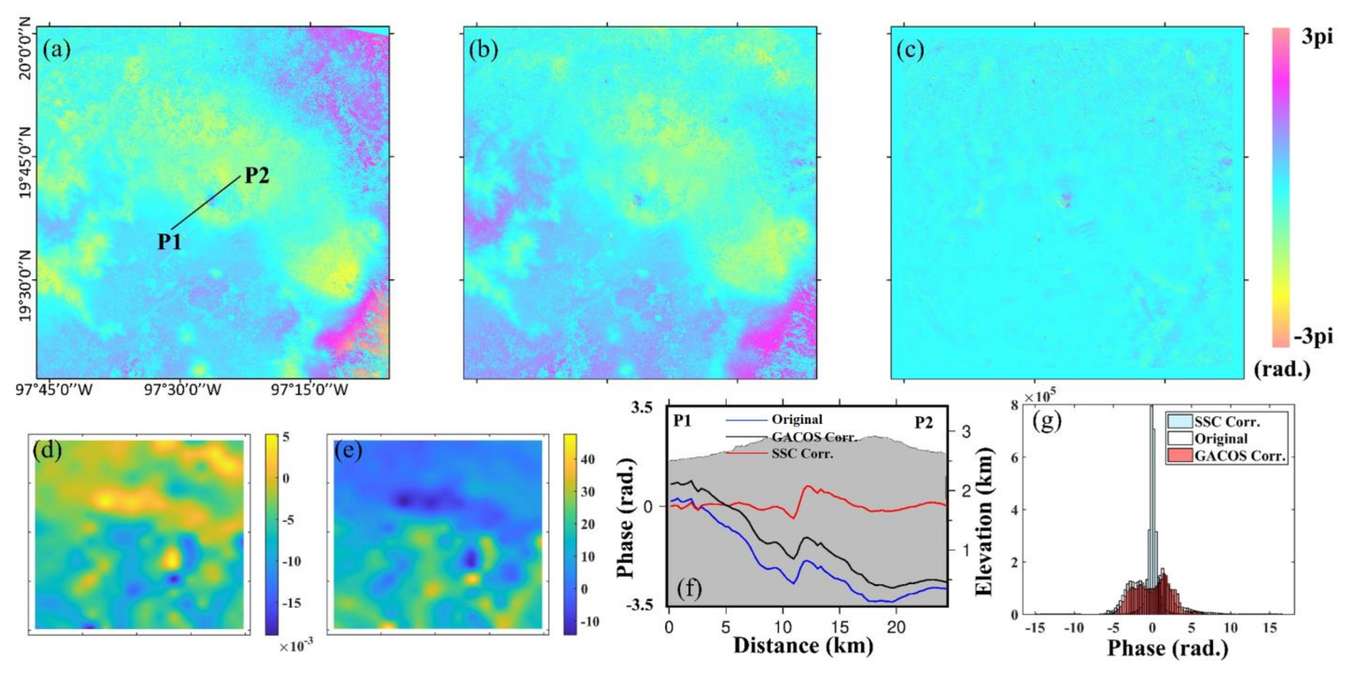
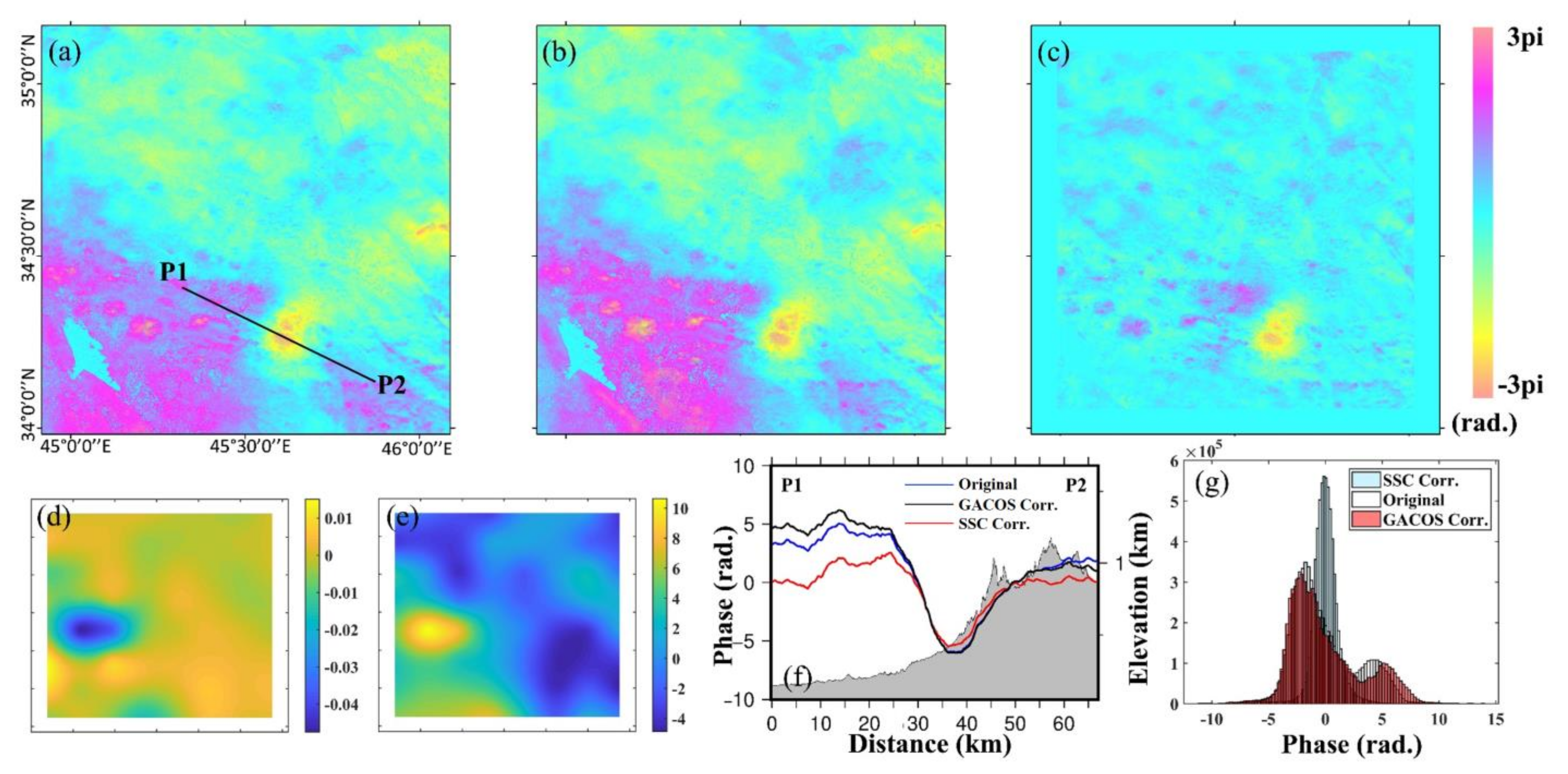
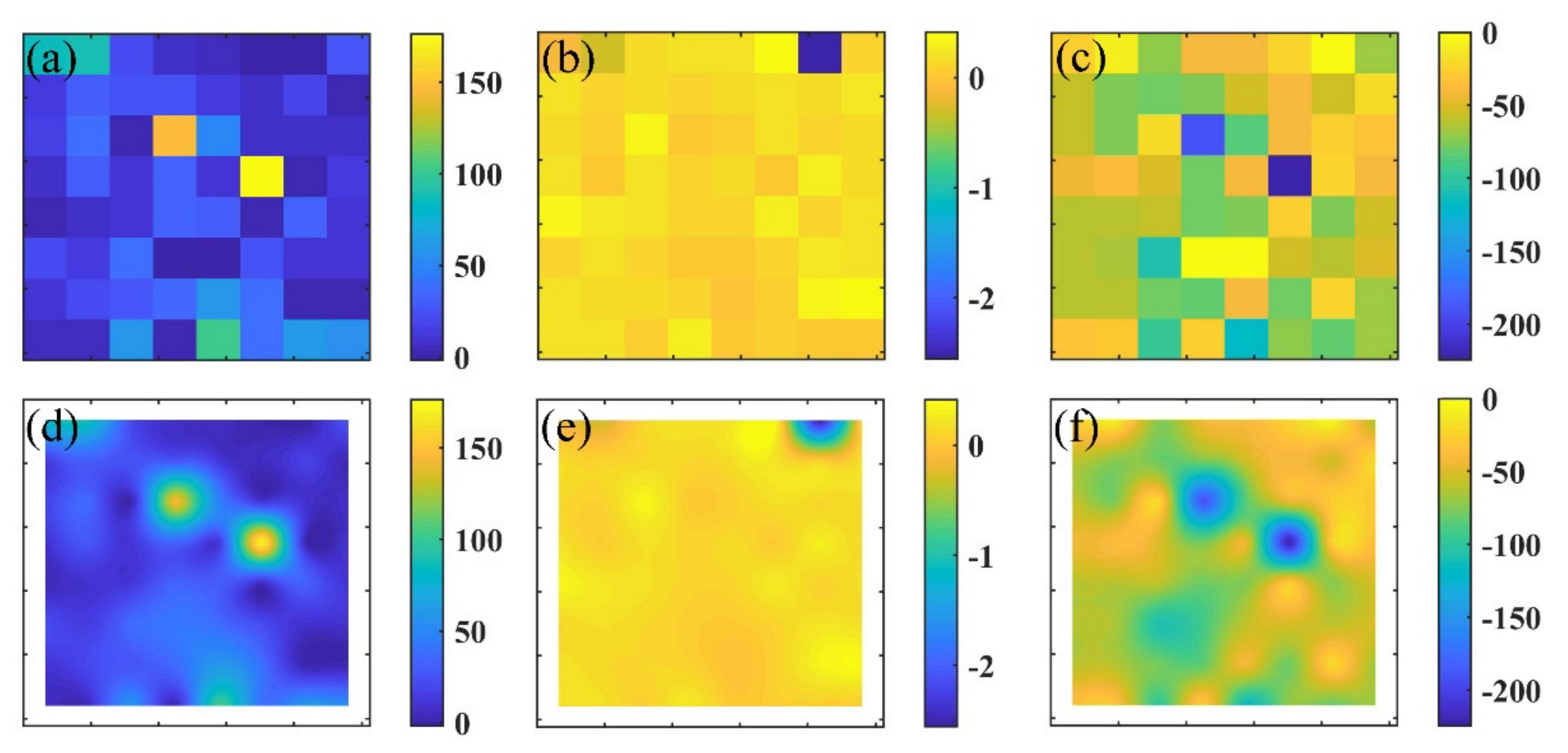
As shown in Figure 2 and Figure 3, we took two earthquakes, the Mw 4.8 Mexico earthquake and the Mw 6.5 Iran earthquake, as examples for our demonstration. These two earthquakes had the minimum and maximum magnitudes in all our tested earthquakes, respectively. These two figures demonstrated interferograms before and after the atmospheric delay correction using our SSC method and the GACOS products. For these two examples, both the GACOS and SSC reduced the noises, but at different levels. The residual signals after SSC in the corrected interferograms (Figure 2c and Figure 3c) were likely the localized phase noises (e.g., the small scale turbulence or localized stratification). The plots (d,e) of Figure 2 and Figure 3 are the scale and offset parameter maps after kriging interpolation. The unit of digital elevation applied in the modeling was meter; therefore, Figure 2d shows a relatively small value range. Both Figure 2f and Figure 3f show the displacement differences along a profile across the coseismic zone after the correction. Figure 2g and Figure 3g are the histograms calculated from non-deforming pixels that were identified using the same masks in SSC implementation. They show an apparent change in the shape of displacement distribution, where the SSC largely reduced the tropospheric delays. The correction results for all other earthquakes are demonstrated in the Supplementary Materials (Figures S1–S21).
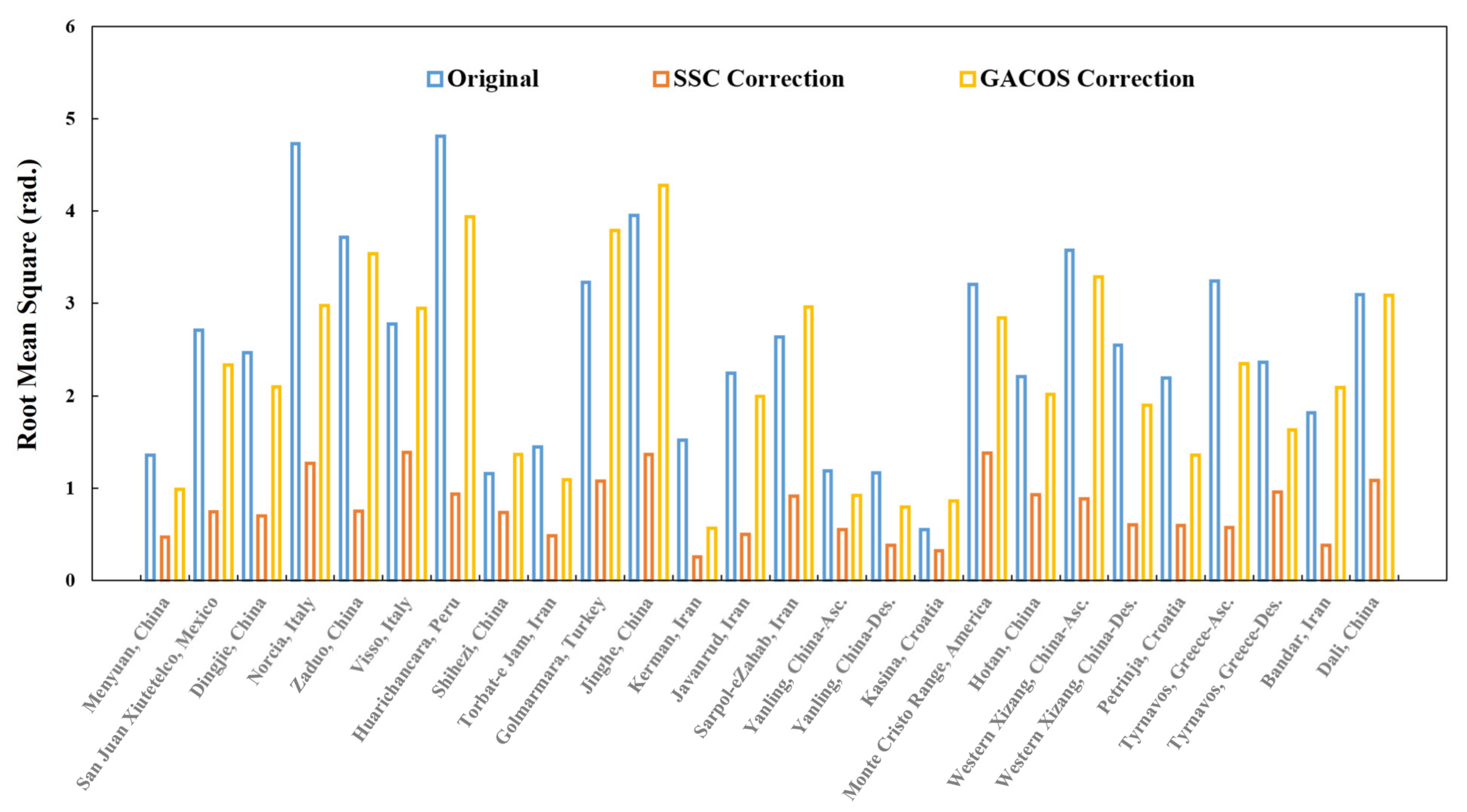
Additionally, we calculated the Root-Mean-Square (RMS) value before and after the atmospheric correction over the non-deforming zone as a statistic factor to evaluate the overall correction quality. This value was used to indicate an overall level of phase noise in each interferogram. The result is summarized in Figure 4. After implementing our SSC, most interferograms had a reduced RMS by 45%.
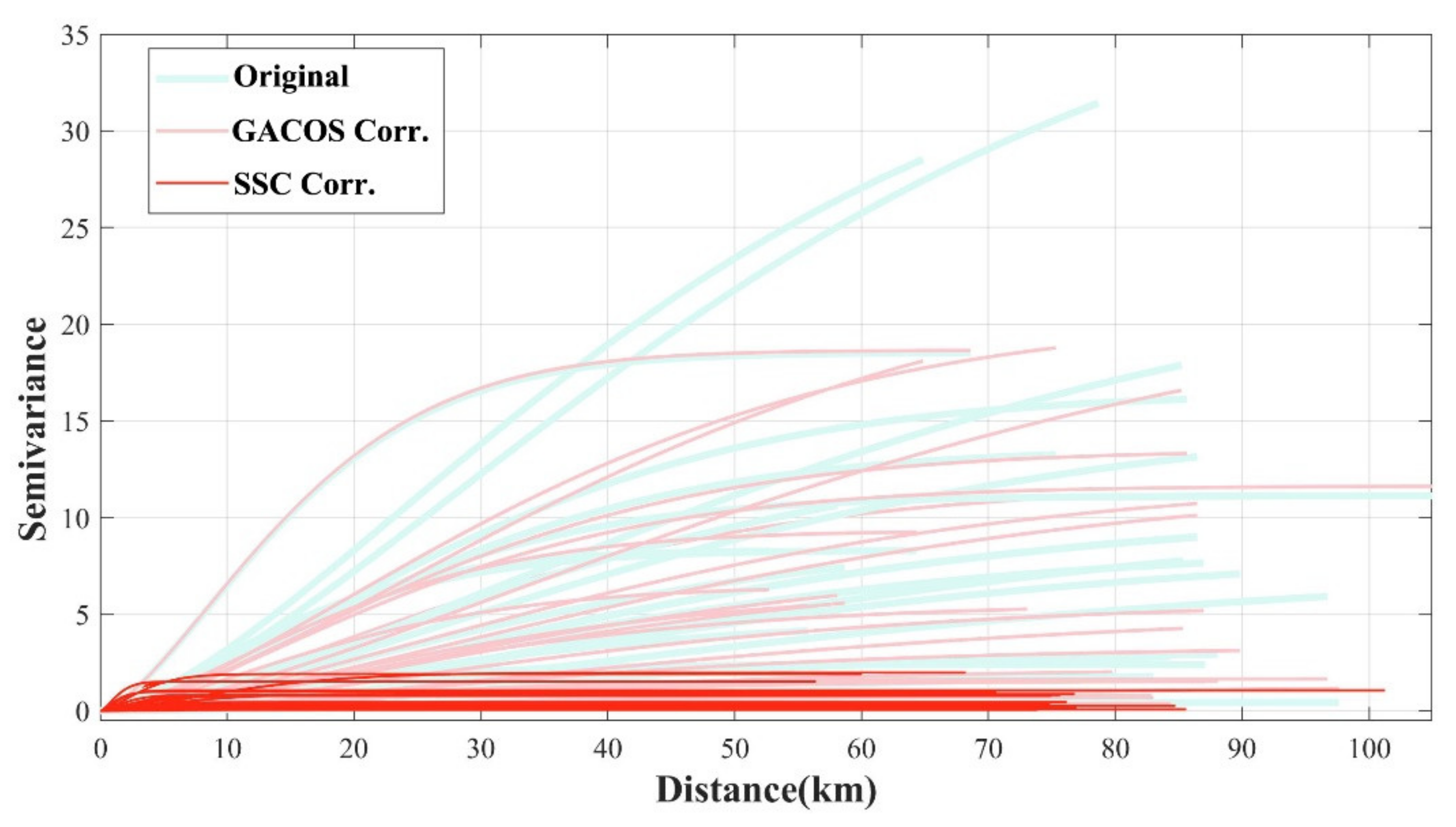
We also calculated the semivarigoram to quantify the reduction in the noise magnitude at various spatial scales. The semivariogram depicts the spatial autocorrelation of the sampled measurements and was used to quantify the atmospheric impacts in many previous studies (e.g., [20,40,49]). Note that we excluded pixels at deforming zones in the calculation.
As shown in Figure 5, SSC performs well for all tested coseismic interferograms, with a significant reduction in semi-variance. In this study, the SSC-corrected interferograms showed a reduction of 5 to 20 km at an overall spatial scale. This was likely related to (1) the spatial size of the coseismic zone; (2) the parameters used in the SSC correction, especially the number of windows; and (3) the spatial scale of the regional terrain. Here, we took the Mw 6.5 Sarpol-e Zahab, Iran, earthquake (Figure 3) as an example. After cropping the interferogram into a 2N by 2N dimension, the subset was then split into 8 × 8 windows and each window corresponded to a spatial size of ~17 km × 17 km. Note that we did not expect to accurately reconstruct the real phase-elevation parameters below this spatial scale (e.g., smaller than a single window size). Hence, the atmospheric signals related to local terrain or turbulence signal with small spatial scale remained as residuals in the corrected interferograms.
Overall, the SSC method provided a satisfactory performance, validated by both semi-variance and RMS. Another advantage of the SSC method was that it only used a single interferogram. Compared to the multi-temporal-analysis-based tropospheric correction methods (e.g., [32,33,34]), our SSC could perform as long as a single interferogram was available. In this study, the GACOS products could also reduce partial atmospheric delays. The inconsistent correction quality of GACOS may be caused by the input atmospheric reanalysis products or by the GNSS meteorological products in each single case.

4. Discussion

In this section, we inspect the optimal parameter settings in SSC and its performance dependence to regional terrain. We also discuss the link of the parameters of the empirical phase-elevation model to the tropospheric contributions. This analysis help us in understanding which part of tropospheric artifacts could be modeled.

4.1. Parameter Setting

To implement the SSC, there were three parameters that had to be empirically set up. The first one was the size of image subset covering the coseismic zone, which was cropped from the uncorrected unwrapped interferogram. This was not a critical step, and the SSC could be implemented into an entire interferogram. This step was conducted in order to improve computation efficiency and to exclude large water bodies (e.g., oceans). To generate this subset, we required (1) enough land area surrounding a coseismic zone, ensuring sufficient pixels for phase-elevation parameter estimation, and (2) an image subset having a dimension of M × 2 N in width and length, ensuring that the number of windows in both directions was × 2 i   (   i < 16 ).
The second empirically determined input was the mask of the coseismic zone. The mask, or an equivalent method of reducing the estimation bias caused by coseismic deformation, could be realized via a spatiotemporal filter. For example, Murray et al. [40] built a temporal low-pass filter to identify and mask deforming pixels. Bekaert et al. [42] applied a band filter, which was constructed based on an initial analysis with InSAR and GNSS, to avoid contamination of the tectonic slow slip deformation signal. Given that the rupture length of small-to-moderate earthquakes with Mw 6.5 may be limited to 10–20 km in length or less (e.g., an Mw 6.5 event may produce a rupture of about 20 km [50]), and concentrating on a known tectonic area from a seismically determined epicenter, we built a rectangle mask for each earthquake. The spatial extent of the mask was generally controlled by the earthquake’s magnitude and focal depth. In this study, the mask zone was manually set up mainly based on USGS reported epicenters. The overall length of the masks for all of the events here ranged from 3.3 to 33 km. Here, we also proposed a potential treatment to generate a proper mask in an automatic way, to allow for possible use in future applications. First, one can predict a spatial size of the coseismic displacement zone with a facility’s (e.g., via U.S. Geological Survey Earthquake Hazards Program) reported focal mechanism parameters. In other words, the size of the mask could be considered as a known. Thereafter, one could search for an optimal masking location by minimizing the standard deviation of un-masked pixel phases. As suggested by a previous study [51], the average distance between an InSAR-reported epicenter and one from USGS was 3.7 km for Iranian earthquakes, and 2.7 km for Japanese earthquakes. Therefore, the search could be started from USGS-reported epicenters and bounded in a limited zone within a several-kilometers radius.
The third consideration is the number of segmented windows. As shown in Table 1, we preferentially segmented the interferogram into 8 × 8 window subsets for most of the events. For a few earthquakes with smaller magnitudes or deeper depths, we applied finer window segmentation (16 × 16). For earthquakes with similar moment magnitudes (Mw 4.5–6.5), an 8 × 8 window segmentation was sufficiently effective. To guarantee the correction quality, we suggest not splitting an image into very fine equal-size windows. Because the number of pixels of a smaller window would be reduced, the chance of them capturing stratification delays presented in areas with a sufficient signal-to-noise ratio became smaller. This would reduce the robustness of the phase-elevation model’s parameter regression. In addition, it would leave more “blind” windows sitting inside the coseismic displacement zone. As mentioned above, for those windows containing insufficient number of pixels to capture the atmospheric delay, calculation could only be done by kriging interpolation instead of by direct phase-elevation regression. However, the derived windows could not be too coarse; otherwise, a single window could be controlled by a multiple trend of phase-elevation dependence.

4.2. Relationship with Regional Terrain

We compared the percentage of the RMS reduction value with the regional terrain conditions in order to quantify the terrain’s dependence of correction quality. This helped us to better understand its future application scenario. We took the RMS in Figure 4 and calculated the corresponding reduction percentage in each case. Figure 6 visually demonstrates the comparison of the mean and standard deviation (SD) of the regional elevation. It shows that a reduction was >60% for most of the tested cases. For those with an average elevation <2.5 km, the reduction ranged from 30% to 90%. For the other interferograms with a higher average elevation, the correction percentage was >50%. However, we did not see a correlation between the quality of correction and the regional terrain complexity according to the SD of the height.

4.3. Regression Models and Parameters

As presented above, the linear approximation [39] between atmospheric delays and local topography can be described by a scale factor and a constant. If we apply the phase-elevation model to an entire interferogram, the constant parameter is only a shift of the interferogram [45]. The estimation of phase-elevation model parameters is implemented for each individual window in the SSC method. Thus, the estimated constant parameter is an overall phase shift of each window. This shift describes the regional long wavelength signals and should be smooth in space. Therefore, after the spatial kriging interpolation, the whole map of the constant parameter approximates the long wavelength signal, which is likely composed of both turbulence and stratification components, while the estimation of the scale parameter (K in Equation (1)) describes the relationship between the phase and the regional elevation. Both the de-correlated pixels and those pixels within the coseismic zones should be pre-masked before the estimation.
After spatial interpolation of the K field, we obtained a pixel-by-pixel map that could be used to model stratification within the interferogram subset. Therefore, according to meaning of the parameter pair in the phase-elevation model and also the choice of spatial interpolation in the SSC procedure, this method estimated not only stratification but also some amount of large-scale troposphere phases.
As suggested by Bekaert et al. [41], the linearization assumption is only valid for the lower part of the atmosphere. Bekaert et al. suggested a power-law model that predicted that the phase delay would converge to zero at larger elevations. To integrate the power-law model into our SSC method, we modified the power-law model by adding an offset parameter ε (see Equation (3)).
ϕ s t r a = A × h 0 h α + ε
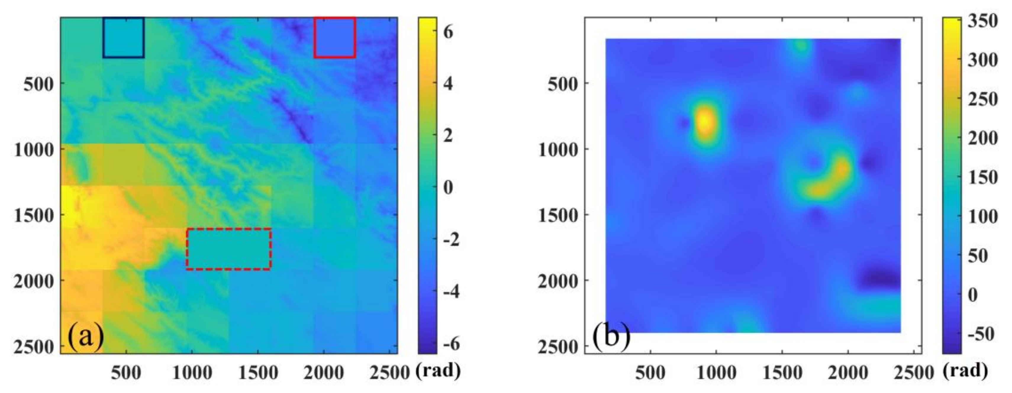
This is because the offset term can be used to represent the overall shift within each window that is caused by the atmospheric delays with a large spatial scale, as discussed above. Figure 7a–c shows the SSC resolved three parameters (scale parameter A, power parameter α , and offset parameter ε ) at each window. Figure 7d–f shows the results after applying kriging interpolation. Figure 8 demonstrates the resulting stratification delay maps based on the window-wise parameters and interpolated parameter maps. Figure 8a indicates that the power-law model works well when each window is only associated with a single set of estimated parameters. However, we could not produce a meaningful phase-delay result (Figure 8b) when using interpolated parameter maps. Even the overall spatial pattern after kriging remained similar to the original window-wise parameters (see Figure 7). The failure here was likely because these variables in the power-law model remain invariant across a certain area; thus, they do not satisfy the spatially smooth assumption in the SSC strategy.
The dashed box in Figure 8 denotes the masked coseismic zone, while the solid box denotes windows where the nonlinear inversion failed in finding optimal values. The failure was mainly because the phase-elevation relationship was weak at these windows (e.g., a flat zone). For example, the dark blue window in Figure 8 bounds a region identical to that outline by the box with the same color in Figure 1a. Both the linear model and the power-law model show unsatisfied performance in this area. The region in the red solid box has some terrain relief (with a height SD of 180.0 m), while also failed in modeling power-law model parameters. The difficulty was caused by the mixing of multiple phase-elevation dependence in this window. Overall, the linear-model-based SSC method is preferred and performed well on the tested coseismic cases.

5. Conclusions

InSAR observations provide rich products for building a geodetic earthquake catalogue. Nevertheless, the accuracy and the capability of earthquake deformation observations are largely dependent on the atmospheric noisy level of the derived displacement field. Focusing on the coseismic displacement field reconstruction for small-to-moderate earthquakes (<Mw 6.5), we developed a Simple-Stratification-Correction (SSC) method based on the phase-elevation relationship and spatial smooth property of the troposphere. SSC employs a windows-based segmentation strategy, given its simplicity and efficiency. By applying the spatial-correlation property of atmospheric delays, SSC allows for the phase-elevation dependence variant in space. The developed SSC method is especially useful for zones with complex terrain, where the stratification delay is most severe. Our method is also helpful in mitigating some large-scale turbulence signals, according to the property of the offset term in the phase-elevation model and its usage in the SSC approach.
In SSC method, a proper mask is necessary to exclude impacts from the coseismic signal in the tropospheric phase modeling, which can reduce the bias from coseismic displacement signals. We also determined the optimal parameter setting to implement SSC for earthquake events with moment magnitude (Mw) 4.5 to 6.5. SSC only needs a single interferometic pair, rather than an interferogram stack, and thus can provide a quicker response after an earthquake. A single interferogram can maintain better coherence with the shortest available temporal baseline. This method can also be integrated in time series analysis that would have a broad implication for other tectonic studies [52,53], e.g., assessing interseismic displacement [54,55]. The key to initiate such applications with SSC is to provide a proper mask or other analysis schemes (e.g., integrating it in a small baseline approach [56]) that can reduce the bias in atmospheric signal modeling.
Overall, by improving the accuracy of the co-seismic displacement field, one could retrieve the seismogenic parameters with better quality that facilitate the building and expansion of the geodetic earthquake catalogue. Thus, it allows us to extend the capacity of InSAR in detecting and monitoring small earthquakes, increasing the number of the geodetic-based earthquake studies, and improving the quality of geodetic earthquake catalogues. Our method is ready to be integrated into an operational InSAR processing chain, e.g., one can produce an additional atmospheric phase screen map via SSC as an auxiliary product to help users understand the amount of stratification delays in each coseismic interferogram.

Supplementary Materials

The following supporting information can be downloaded at: https://www.mdpi.com/article/10.3390/rs14061425/s1. This file contains Figure S1–S21: Interferograms before and after tropospheric corrections of the rest 21 earthquake events tested in this study are listed here. Figure S1: Correction result for the Mw 5.87 earthquake in Menyuan, China, on 20 January 2016. Figure S2: Correction result for the Mw 5.58 earthquake in Dingjie, China, on 22 May 2016. Figure S3: Correction result for the Mw 6.16 earthquake in Norcia, Italy, on 24 August 2016. Figure S4: Correction result for the Mw 5.58 earthquake in Zaduo, China, on 17 October 2016. Figure S5: Correction result for the Mw 6.28 earthquake in Visso, Italy, on 26 October 2016. Figure S6: Correction result for the Mw 6.18 earthquake in Huarichancara, Peru, on 1 December 2016. Figure S7: Correction result for the Mw 5.82 earthquake in Shihezi, China, on 8 December 2016. Figure S8: Correction result for the Mw 6.14 earthquake in Torbat-e Jam, Iran, on 5 April 2017. Figure S9: Correction result for the Mw5.58 earthquake in Golmarmara, Turkey, on 27 May 2017. Figure S10: Correction result for the Mw6.19 earthquake in Jinghe, China, on 8 August 2017. Figure S11: Correction result for the Mw6.08 earthquake in Kerman, Iran, on 1 December 2017. Figure S12: Correction result for the Mw5.98 earthquake in Javanrud, Iran, on 25 August 2018. Figure S13: Correction result for the Mw 4.83 earthquake in Yanling, China, on 5 February 2019. Figure S14: Correction result for the Mw5.55 earthquake in Kasina, Croatia, on 22 March 2020. Figure S15: Correction result for the Mw6.44 earthquake in Monte Cristo Range, America, on 15 May 2020. Figure S16: Correction result for the Mw6.28 earthquake in Hotan, China, on 25 June 2020. Figure S17: Correction result for the Mw 6.36 earthquake in Western Xizang, China, on 22 July 2020. Figure S18: Correction result for the Mw6.48 earthquake in Petrinja, Croatia, on 29 December 2020. Figure S19: Correction result for the Mw 6.39 earthquake in Tyrnavos, Greece, on 3 March 2021. Figure S20: Correction result for the Mw6.10 earthquake in Bandar, Iran, on 18 April 2021. Figure S21: Correction result for the Mw6.09 earthquake in Dali, China, on 21 May 2021.

Author Contributions

Conceptualization, W.G.; methodology, W.G.; validation, W.G., C.Z. and C.L.; investigation, W.G, D.Z. and Y.Z.; writing—original draft preparation, W.G.; writing—review and editing, W.G., D.Z., Y.Z., C.L., G.Z. and X.S.; supervision, X.S.; funding acquisition, X.S. and W.G. All authors have read and agreed to the published version of the manuscript.

Funding

This research was supported by the National Key Research and Development Program of China (Grant No. 2019YFC1509201), Basic Scientific Funding of the Institute of Geology, China Earthquake Administration (No. IGCEA1719, Institute of Geology), the National Natural Science Foundation of China (Grant No. 42174015), and the China Seismic Experimental Site (CSES) program (China Earthquake Administration).

Institutional Review Board Statement

Not applicable.

Informed Consent Statement

Not applicable.

Data Availability Statement

The Sentinel-1 dataset was provided by the European Space Agency (ESA), through the Alaska Satellite Facility (https://vertex.daac.asf.alaska.edu/, accessed on 4 March 2022). Some Sentinel-1 interferograms were produced via the SARVIEWS project (https://sarviews-hazards.alaska.edu/, accessed on 4 March 2022), through download from Alaska Satellite Facility Data Center.

Acknowledgments

We would like to thank all of the anonymous reviewers for their insightful comments on the paper.

Conflicts of Interest

The authors declare no conflict of interest.

References

  1. Lohman, R.B.; Simons, M. Locations of selected small earthquakes in the Zagros mountains. Geochem. Geophys. Geosyst. 2005, 6, Q03001. [Google Scholar] [CrossRef]
  2. Dawson, J.; Tregoning, P. Uncertainty analysis of earthquake source parameters determined from InSAR: A simulation study. J. Geophys Res.-Sol. Earth 2007, 112, B09406. [Google Scholar] [CrossRef] [Green Version]
  3. Funning, G.J.; Parsons, B.; Wright, T.J.; Jackson, J.A.; Fielding, E.J. Surface displacements and source parameters of the 2003 Bam (Iran) earthquake from Envisat advanced synthetic aperture radar imagery. J. Geophys. Res. Solid Earth 2005, 110, B09406. [Google Scholar] [CrossRef] [Green Version]
  4. Mellors, R.J.; Magistrale, H.; Earle, P.; Cogbill, A.H. Comparison of four moderate-size earthquakes in southern California using seismology and InSAR. Seismol. Soc. Am. 2004, 94, 2004–2014. [Google Scholar] [CrossRef] [Green Version]
  5. Kwong, K.B.; DeShon, H.R.; Kim, J.W.; Lu, Z. Resolving Teleseismic Earthquake Catalog and InSAR Data Discrepancies in Absolute Space to Explore Rupture Complexity Along the Ecuadorian Megathrust Fault. J. Geophys. Res. Solid Earth 2019, 124, 6703–6719. [Google Scholar] [CrossRef] [Green Version]
  6. Weston, J.; Ferreira, A.M.G.; Funning, G.J. Global compilation of interferometric synthetic aperture radar earthquake source models: 1. Comparisons with seismic catalogs. J. Geophys. Res. Solid Earth 2011, 116, B08408. [Google Scholar] [CrossRef] [Green Version]
  7. Ferreira, A.M.G.; Weston, J.; Funning, G.J. Global compilation of interferometric synthetic aperture radar earthquake source models: 2. Effects of 3-D Earth structure. J. Geophys. Res. Solid Earth 2011, 116, B08409. [Google Scholar] [CrossRef]
  8. Wang, R.; Diao, F.; Hoechner, A. SDM—A geodetic inversion code incorporating with layered crust structure and curved fault geometry. In Proceedings of the General Assembly European Geosciences Union, Vienna, Austria, 7–12 April 2013. [Google Scholar]
  9. Tong, X.; Sandwell, D.T.; Fialko, Y. Coseismic slip model of the 2008 Wenchuan earthquake derived from joint inversion of interferometric synthetic aperture radar, GPS, and field data. J. Geophys. Res. Solid Earth 2010, 115, B04314. [Google Scholar] [CrossRef] [Green Version]
  10. Isken, M.; Sudhaus, H.; Heimann, S.; Steinberg, A.; Daout, S.; Vasyura-Bathke, H. Kite—Software for Rapid Earthquake Source Optimisation from InSAR Surface Displacement; V.0.1; GFZ Data Services: Potsdam, Germany, 2017. [Google Scholar]
  11. Lindsey, E.O.; Natsuaki, R.; Xu, X.; Shimada, M.; Hashimoto, M.; Melgar, D.; Sandwell, D.T. Line-of-sight displacement from ALOS-2 interferometry: Mw 7.8 Gorkha Earthquake and Mw 7.3 aftershock. Geophys. Res. Lett. 2015, 42, 6655–6661. [Google Scholar] [CrossRef]
  12. Elliott, J.R.; Walters, R.J.; Wright, T.J. The role of space-based observation in understanding and responding to active tectonics and earthquakes. Nat. Commun. 2016, 7, 13844. [Google Scholar] [CrossRef] [Green Version]
  13. Zhu, C.; Wang, C.; Zhang, B.; Qin, X.; Shan, X. Differential Interferometric Synthetic Aperture Radar data for more accurate earthquake catalogs. Remote Sens. Environ. 2021, 266, 112690. [Google Scholar] [CrossRef]
  14. Pepe, A.; Calò, F. A Review of Interferometric Synthetic Aperture RADAR (InSAR) Multi-Track Approaches for the Retrieval of Earth’s Surface Displacements. Appl. Sci. 2017, 7, 1264. [Google Scholar] [CrossRef] [Green Version]
  15. Hooper, A.; Bekaert, D.; Spaans, K.; Arıkan, M. Recent advances in SAR interferometry time series analysis for measuring crustal deformation. Tectonophysics 2012, 514–517, 1–13. [Google Scholar] [CrossRef]
  16. Lohman, R.B.; Simons, M. Some thoughts on the use of InSAR data to constrain models of surface deformation: Noise structure and data downsampling. Geochem. Geophys. Geosystems 2005, 6, Q01007. [Google Scholar] [CrossRef]
  17. Zhang, Y.; Shan, X.; Gong, W.; Zhang, G. The ambiguous fault geometry derived from InSAR measurements of buried thrust earthquakes: A synthetic data based study. Geophys. J. Int. 2021, 225, 1799–1811. [Google Scholar] [CrossRef]
  18. Xu, W.; Dutta, R.; Jónsson, S. Identifying Active Faults by Improving Earthquake Locations with InSAR Data and Bayesian Estimation: The 2004 Tabuk (Saudi Arabia) Earthquake Sequence. Seismol. Soc. Am. 2015, 105, 765–775. [Google Scholar] [CrossRef] [Green Version]
  19. Williams, S.; Bock, Y.; Fang, P. Integrated satellite interferometry: Tropospheric noise, GPS estimates and implications for interferometric synthetic aperture radar products. J. Geophys. Res. Solid Earth 1998, 103, 27051–27067. [Google Scholar] [CrossRef]
  20. Hanssen, R. Radar Interferometry: Data Interpretation and Error Analysis, 1st ed.; Kluwer Academic Publishers: Dordrecht, The Netherlands, 2001; Volume 2. [Google Scholar]
  21. Massonnet, D.; Feigl, K.L. Radar interferometry and its application to changes in the earth’s surface. Rev. Geophys. 1998, 36, 441–500. [Google Scholar] [CrossRef] [Green Version]
  22. Emardson, T.R.; Simons, M.; Webb, F.H. Neutral atmospheric delay in interferometric synthetic aperture radar applications: Statistical description and mitigation. J. Geophys. Res.-Sol. Earth 2003, 108, 2231. [Google Scholar] [CrossRef]
  23. Funning, G.J.; Garcia, A. A systematic study of earthquake detectability using Sentinel-1 Interferometric Wide-Swath data. Geophys. J. Int. 2018, 216, 332–349. [Google Scholar] [CrossRef] [Green Version]
  24. Webley, P.W.; Bingley, R.M.; Dodson, A.H.; Wadge, G.; Waugh, S.J.; James, I.N. Atmospheric water vapour correction to InSAR surface motion measurements on mountains: Results from a dense GPS network on Mount Etna. Phys. Chem. Earth 2002, 27, 363–370. [Google Scholar] [CrossRef]
  25. Onn, F.; Zebker, H.A. Correction for interferometric synthetic aperture radar atmospheric phase artifacts using time series of zenith wet delay observations from a GPS network. J. Geophys. Res. Solid Earth 2006, 111, B09102. [Google Scholar] [CrossRef]
  26. Li, Z.H.; Muller, J.P.; Cross, P.; Fielding, E.J. Interferometric synthetic aperture radar (InSAR) atmospheric correction: GPS, moderate resolution Imaging spectroradiometer (MODIS), and InSAR integration. J. Geophys. Res.-Sol. Earth 2005, 110, B03410. [Google Scholar] [CrossRef]
  27. Gong, W.; Meyer, F.J.; Lee, C.W.; Lu, Z.; Freymueller, J. Measurement and interpretation of subtle deformation signals at Unimak Island from 2003 to 2010 using weather model-assisted time series InSAR. J. Geophys. Res. Solid Earth 2015, 120, 1175–1194. [Google Scholar] [CrossRef]
  28. Webley, P.W.; Wadge, G.; James, I.N. Determining radio wave delay by non-hydrostatic atmospheric modelling of water vapour over mountains. Phys. Chem. Earth 2004, 29, 139–148. [Google Scholar] [CrossRef]
  29. Jolivet, R.; Grandin, R.; Lasserre, C.; Doin, M.P.; Peltzer, G. Systematic InSAR tropospheric phase delay corrections from global meteorological reanalysis data. Geophys. Res. Lett. 2011, 38, L17311. [Google Scholar] [CrossRef] [Green Version]
  30. Jolivet, R.; Agram, P.S.; Lin, N.N.Y.; Simons, M.; Doin, M.P.; Peltzer, G.; Li, Z.H. Improving InSAR geodesy using Global Atmospheric Models. J. Geophys. Res.-Sol. Earth 2014, 119, 2324–2341. [Google Scholar] [CrossRef]
  31. Yu, C.; Li, Z.; Penna, N.T.; Crippa, P. Generic Atmospheric Correction Model for Interferometric Synthetic Aperture Radar Observations. J. Geophys. Res. Solid Earth 2018, 123, 9202–9222. [Google Scholar] [CrossRef]
  32. Luo, H.; Wang, T.; Wei, S.; Liao, M.; Gong, J. Deriving Centimeter-Level Coseismic Deformation and Fault Geometries of Small-To-Moderate Earthquakes From Time-Series Sentinel-1 SAR Images. Front. Earth Sci. 2021, 9, 32. [Google Scholar] [CrossRef]
  33. Hou, L.; Shan, X.; Gong, W.; Zhang, Y.; Luo, H.; Zhao, D. Characterizing seismogenic fault of 2016 Dingjie earthquake based on multitemporal DInSAR. Chin. J. Geophys. 2020, 63, 1357–1369. [Google Scholar] [CrossRef]
  34. Daout, S.; Sudhaus, H.; Kausch, T.; Steinberg, A.; Dini, B. Interseismic and Postseismic Shallow Creep of the North Qaidam Thrust Faults Detected with a Multitemporal InSAR Analysis. J. Geophys. Res. Solid Earth 2019, 124, 7259–7279. [Google Scholar] [CrossRef]
  35. Dong, J.; Zhang, L.; Liao, M.; Gong, J. Improved correction of seasonal tropospheric delay in InSAR observations for landslide deformation monitoring. Remote Sens. Environ. 2019, 233, 111370. [Google Scholar] [CrossRef]
  36. Knospe, S.H.G.; Jonsson, S. Covariance Estimation for dInSAR Surface Deformation Measurements in the Presence of Anisotropic Atmospheric Noise. IEEE Trans. Geosci. Remote Sens. 2010, 48, 2057–2065. [Google Scholar] [CrossRef]
  37. Agram, P.S.; Simons, M. A noise model for InSAR time series. J. Geophys. Res.-Sol. Earth 2015, 120, 2752–2771. [Google Scholar] [CrossRef]
  38. Lin, Y.N.N.; Simons, M.; Hetland, E.A.; Muse, P.; DiCaprio, C. A multiscale approach to estimating topographically correlated propagation delays in radar interferograms. Geochem. Geophys. Geosystems 2010, 11, Q09002. [Google Scholar] [CrossRef]
  39. Cavalié, O.; Doin, M.-P.; Lasserre, C.; Briole, P. Ground motion measurement in the Lake Mead area, Nevada, by differential synthetic aperture radar interferometry time series analysis: Probing the lithosphere rheological structure. J. Geophys. Res. Solid Earth 2007, 112, B03403. [Google Scholar] [CrossRef] [Green Version]
  40. Murray, K.D.; Lohman, R.B.; Bekaert, D.P.S. Cluster-Based Empirical Tropospheric Corrections Applied to InSAR Time Series Analysis. IEEE Trans. Geosci. Remote Sens. 2021, 59, 2204–2212. [Google Scholar] [CrossRef]
  41. Bekaert, D.P.S.; Hooper, A.; Wright, T.J. A spatially-variable power-law tropospheric correction technique for InSAR data. J. Geophys. Res. Solid Earth 2015, 120, 1345–1356. [Google Scholar] [CrossRef]
  42. Bekaert, D.P.S.; Hooper, A.; Wright, T.J. Reassessing the 2006 Guerrero slow slip event, Mexico: Implications for large earthquakes in the Guerrero Gap. J. Geophys. Res. Solid Earth 2015, 120, 1357–1375. [Google Scholar] [CrossRef]
  43. Bejar-Pizarro, M.; Socquet, A.; Armijo, R.; Carrizo, D.; Genrich, J.; Simons, M. Andean structural control on interseismic coupling in the North Chile subduction zone. Nat. Geosci. 2013, 6, 462–467. [Google Scholar] [CrossRef] [Green Version]
  44. Liang, H.; Zhang, L.; Ding, X.; Lu, Z.; Li, X. Toward Mitigating Stratified Tropospheric Delays in Multitemporal InSAR: A Quadtree Aided Joint Model. IEEE Trans. Geosci. Remote Sens. 2019, 57, 291–303. [Google Scholar] [CrossRef]
  45. Bekaert, D.P.S. InSAR Time Series Analysis of the 2006 Slow Slip Event on the Guerrero Subduction Zone, Mexico. Master’s Thesis, Delft University of Technology, Delft, The Netherlands, 2010. [Google Scholar]
  46. Doin, M.P.; Lasserre, C.; Peltzer, G.; Cavalie, O.; Doubre, C. Corrections of stratified tropospheric delays in SAR interferometry: Validation with global atmospheric models. J. Appl. Geophys. 2009, 69, 35–50. [Google Scholar] [CrossRef]
  47. Meyer, F.J.; Whitley, M.; Logan, T.; McAlpin, D.B.; Hogenson, K.; Nicoll, J.B. The sarviews project: Automated processing of sentinel-1 sar data for geoscience and hazard response. In Proceedings of the IGARSS 2019—2019 IEEE International Geoscience and Remote Sensing Symposium, Yokohama, Japan, 28 July–2 August 2019; pp. 5468–5471. [Google Scholar]
  48. Gong, W.; Zhang, Y.; Li, T.; Wen, S.; Zhao, D.; Hou, L.; Shan, X. Multi-Sensor Geodetic Observations and Modeling of the 2017 Mw 6.3 Jinghe Earthquake. Remote Sens. 2019, 11, 2157. [Google Scholar] [CrossRef] [Green Version]
  49. Murray, K.D.; Bekaert, D.P.S.; Lohman, R.B. Tropospheric corrections for InSAR: Statistical assessments and applications to the Central United States and Mexico. Remote Sens. Environ. 2019, 232, 111326. [Google Scholar] [CrossRef]
  50. Wells, D.L.; Coppersmith, K.J. New empirical relationships among magnitude, rupture length, rupture width, rupture area, and surface displacement. Seismol. Soc. Am. 1994, 84, 974–1002. [Google Scholar] [CrossRef]
  51. Ghayournajarkar, N.; Fukushima, Y. Using InSAR for evaluating the accuracy of locations and focal mechanism solutions of local earthquake catalogues. Geophys. J. Int. 2022. [Google Scholar] [CrossRef]
  52. Dal Zilio, L.; Hetényi, G.; Hubbard, J.; Bollinger, L. Building the Himalaya from tectonic to earthquake scales. Nat. Rev. Earth Environ. 2021, 2, 251–268. [Google Scholar] [CrossRef]
  53. Michel, S.; Jolivet, R.; Rollins, C.; Jara, J.; dal Zilio, L. Seismogenic Potential of the Main Himalayan Thrust Constrained by Coupling Segmentation and Earthquake Scaling. Geophys. Res. Lett. 2021, 48, e2021GL093106. [Google Scholar] [CrossRef]
  54. Dal Zilio, L.; Jolivet, R.; van Dinther, Y. Segmentation of the Main Himalayan Thrust Illuminated by Bayesian Inference of Interseismic Coupling. Geophys. Res. Lett. 2020, 47, e2019GL086424. [Google Scholar] [CrossRef] [Green Version]
  55. Grandin, R.; Doin, M.-P.; Bollinger, L.; Pinel-Puysségur, B.; Ducret, G.; Jolivet, R.; Sapkota, S.N. Long-term growth of the Himalaya inferred from interseismic InSAR measurement. Geology 2012, 40, 1059–1062. [Google Scholar] [CrossRef] [Green Version]
  56. Lauknes, T.R. InSAR Tropospheric Stratification Delays: Correction Using a Small Baseline Approach. IEEE Geosci. Remote Sens. Lett. 2011, 8, 1070–1074. [Google Scholar] [CrossRef]
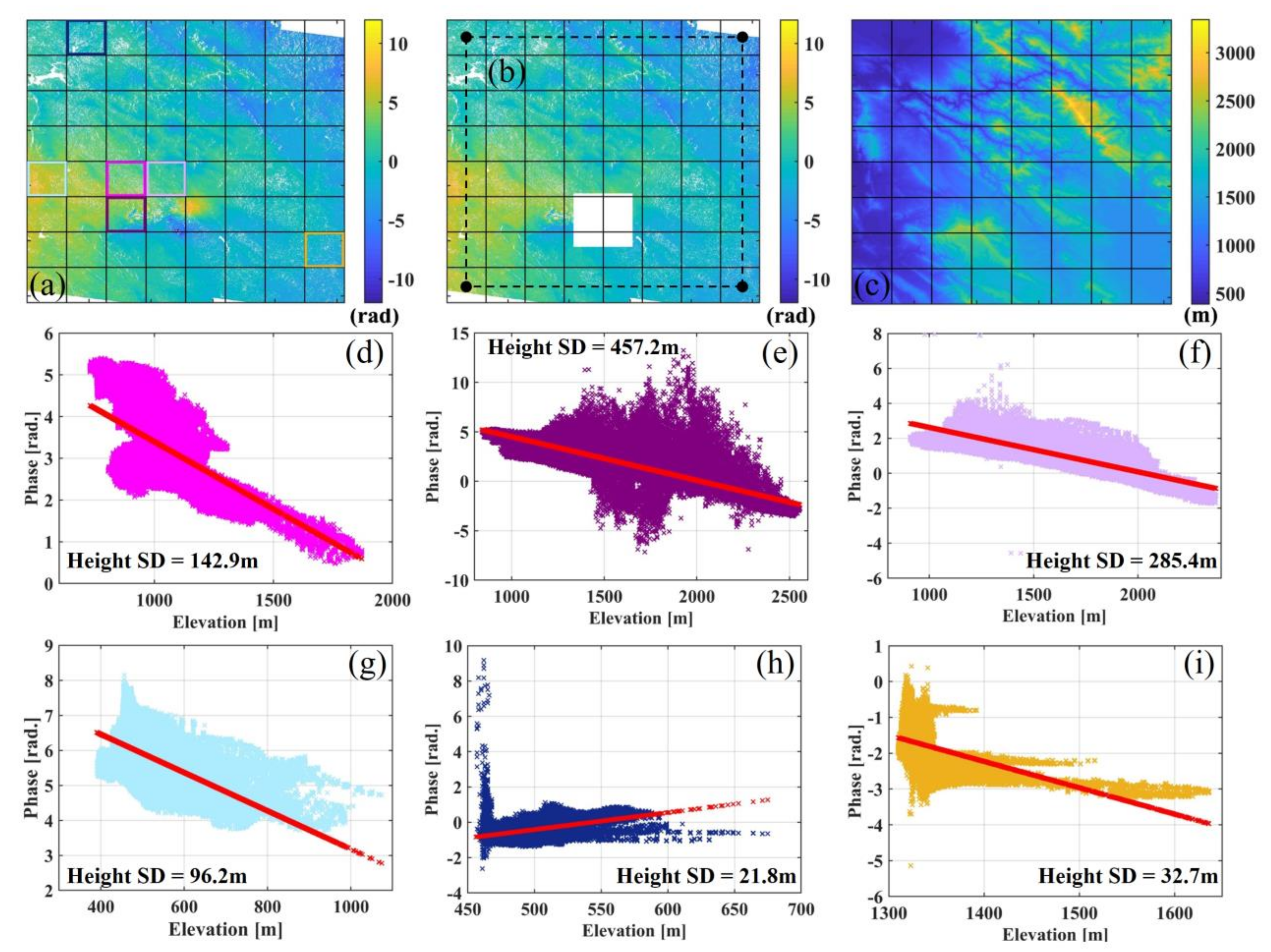
Figure 1. Demonstration of the primary ideal of the developed stratification correction scheme with the 25 August 2018, Mw 5.98 Javanrud, Iran, earthquake as an example: (a) is the interferogram subset with the original unwrapped phase and segmented with an 8 × 8 window; (b) is the unwrapped phase with coseismic zone masked; the dashed box denotes zones computed during interpolation; (c) is the elevation of the corresponding area; (di) are phase-elevation model examples for a single window. The red markers show the computed regression model; other colored markers denote original phase-elevation pixel pairs and they are associated with the box in (a) by the same color.
Remotesensing 14 01425 g001
Figure 2. Examples of atmospheric correction: (ac) are original, GACOS-corrected-, and SSC-corrected interferograms of the Mw 4.83 Mexico earthquake;(d) is the scale factor map; (e) is the offset factor map; (f) shows the phase changes along cross section P1–P2 in (a); (g) is the histogram of (ac) after masking the main coseismic zone.
Remotesensing 14 01425 g002
Figure 3. Examples of atmospheric correction: (ac) are original, GACOS-corrected, and SSC-corrected interferograms of the Mw 6.5 Sarpol-e Zahab, Iran, earthquake; (d) is the scale factor map; (e) is the offset factor map; (f) shows the phase changes along cross section P1–P2 in (a); (g) is the histogram of (ac) after masking the main coseismic zone.
Remotesensing 14 01425 g003
Figure 4. Statistics before and after correction. The Y-axis denotes the RMS value of each case with a unit of radiance. The blue bars denote the image RMS before correction. The red bars denote the image RMS after applying the method developed here. The yellow bars denote the image RMS after correction by GACOS products.
Remotesensing 14 01425 g004
Figure 5. Semivariance of tested earthquake dataset before and after atmosphere correction.
Remotesensing 14 01425 g005
Figure 6. The RMS reduction after SSC vs. average & standard deviation of the local elevation. The X-axis has a unit of kilometer; the Y-axis is the percentage of RMS reduction; the error bar of each marker is scaled by 5 km.
Remotesensing 14 01425 g006
Figure 7. Demonstration of power-law-based SSC method: (ac) show the estimated window-wise scale factor, the power factor, and the offset factor in Equation (3), respectively, and each window is described by a single set of variables; (df) are parameter maps after spatial interpolation, corresponding to the scale factor, the power factor and the offset factor, from left to right.
Remotesensing 14 01425 g007
Figure 8. Resulting stratification delay maps based on the estimated power–law model parameters at each window and the interpolated parameter maps. (a) reconstructed atmospheric delay map base on power-law model with a single set of estimated parameters of each window; (b) reconstructed atmospheric delays base on power-law model with interpolated parameters maps. Dashed box denotes the masked zone. Solid boxes denote where power-law parameter estimation failed.
Remotesensing 14 01425 g008
Table 1. Information of earthquakes (Mw 6.5) tested in this study.
IndexDateLocationLat.
(deg)
Lon.
(deg)
Depth
(km)
MwStrike
(deg)
Dip
(deg)
Rake
(deg)
Patch
Number
120 January 2016Menyuan, China37.72101.6812.505.8712947778
28 February 2016San Juan Xiutetelco, Mexico19.67−97.451.504.83160809616
322 May 2016Dingjie, China28.4887.612.405.5818843−788
424 August 2016Norcia, Italy42.7413.295.006.1616850−838
517 October 2016Zaduo, China32.8894.8210.505.856869−1048
626 October 2016Visso, Italy42.9713.205.006.2815540−918
71 December 2016Huarichancara, Peru−15.29−70.845.506.1815044−928
88 December 2016Shihezi, China43.7986.3319.005.82280618016
95 April 2017Torbat-e Jam, Iran35.8360.448.926.1412442628
10 #27 May 2017Golmarmara, Turkey38.7327.795.005.5830460−8916
118 August 2017Jinghe, China44.2682.7214.056.19904289.568
121 December 2017Kerman, Iran30.7857.347.456.0811951808
1325 August 2018Javanrud, Iran34.6346.245.505.982647848
1425 November 2018Sarpol-e Zahab, Iran34.3945.6014.506.502563−1738
1525 February 2019Yanling, China29.47104.501.674.8317464808
1622 March 2020Kasina, Croatia45.8416.049.155.55461698
1715 May 2020Monte Cristo Range, America38.18−117.939.846.447673−104
1825 June 2020Hotan, China35.6182.479.786.2818668−898
19 #22 July 2020Western Xizang, China33.2086.8210.006.363152−808
2029 December 2020Petrinja, Croatia45.4316.225.006.48120781748
21 #3 March 2021Tyrnavos, Greece39.6322.156.006.3929235−988 (Asc.)
6 (Des.)
2218 April 2021Bandar, Iran29.7250.606.506.1030660818
2321 May 2021Dali, China25.6499.947.006.091349017916
# These three earthquakes had coseismic observations on both the ascending (Asc.) and descending (Des.) tracks.
Publisher’s Note: MDPI stays neutral with regard to jurisdictional claims in published maps and institutional affiliations.