
UAVs for Science in Antarctica


1
Departamento de Ciências da Terra, Universidade de Coimbra, 3004-504 Coimbra, Portugal
2
Instituto de Astrofísica e Ciências do Espaço, Universidade de Coimbra, 3004-504 Coimbra, Portugal
3
CEG—Centro de Estudos Geográficos and Laboratório Associado TERRA, Instituto de Geografia e Ordenamento do Território, Universidade de Lisboa, 1649-004 Lisboa, Portugal
4
POLAR2E—Colégio de Ciências Polares e Ambientes Extremos, Universidade de Lisboa, 1649-004 Lisboa, Portugal
*
Author to whom correspondence should be addressed.
Remote Sens. 2022, 14(7), 1610; https://doi.org/10.3390/rs14071610
Submission received: 20 February 2022
/
Revised: 14 March 2022
/
Accepted: 21 March 2022
/
Published: 28 March 2022
Abstract
:Remote sensing is a very powerful tool that has been used to identify, map and monitor Antarctic features and processes for nearly one century. Satellite remote sensing plays the main role for about the last five decades, as it is the only way to provide multitemporal views at continental scale. But the emergence of small consumer-grade unoccupied aerial vehicles (UAVs) over the past two decades has paved the way for data in unprecedented detail. This has been also verified by an increasing noticeable interest in Antarctica by the incorporation of UAVs in the field activities in diversified research topics. This paper presents a comprehensive review about the use of UAVs in scientific activities in Antarctica. It is based on the analysis of 190 scientific publications published in peer-reviewed journals and proceedings of conferences which are organised into six main application topics: Terrestrial, Ice and Snow, Fauna, Technology, Atmosphere and Others. The analysis encompasses a detailed overview of the activities, identifying advantages and difficulties, also evaluating future possibilities and challenges for expanding the use of UAV in the field activities. The relevance of using UAVs to support numerous and diverse scientific activities in Antarctica becomes very clear after analysing this set of scientific publications, as it is revolutionising the remote acquisition of new data with much higher detail, from inaccessible or difficult to access regions, in faster and cheaper ways. Many of the advances can be seen in the terrestrial areas (detailed 3D mapping; vegetation mapping, discrimination and health assessment; periglacial forms characterisation), ice and snow (more detailed topography, depth and features of ice-sheets, glaciers and sea-ice), fauna (counting penguins, seals and flying birds and detailed morphometrics) and in atmosphere studies (more detailed meteorological measurements and air-surface couplings). This review has also shown that despite the low environmental impact of UAV-based surveys, the increasing number of applications and use, may lead to impacts in the most sensitive Antarctic ecosystems. Hence, we call for an internationally coordinated effort to for planning and sharing UAV data in Antarctica, which would reduce environmental impacts, while extending research outcomes.
1. Introduction
The importance of remote sensing for the knowledge of Antarctica became immediately evident after the development of the first airplane flights in the late 1920s, which allowed discovering more of the hinterland than all previous surveys during the preceding century. The first flight in 1929 by Hubert Wilkins taking off from Deception Island, unveiling much of the northern part of the Antarctic Peninsula, was a milestone [1]. Afterwards, the attempts to make a trans-Antarctic flight, namely the most notable one in 1935 by Herbert Hollick-Kenyon and Lincoln Ellsworth, which achieved the first crossing of the continent from Dundee Island to the Ross Ice-Shelf, revealed the existence of the Trans-Antarctic Mountains [2]. Both of these expeditions allowed taking many photos which, although oblique and not always well geolocated and therefore not adequate for precise mapping, constitute the first remote views of the Antarctic continent.
The systematic cartography with aerial photography started only after the end of the second world war, first with the Ronne Antarctic Research Expedition (RARE) followed about one decade later by the Falkland Islands Dependencies Aerial Survey Expedition (FIDASE) [3]. But it was only after the launching in 1972 of the first civilian satellite ERST-1 (later renamed to Landsat1) that the gate to the spaceborne Earth Observation would finally be open and change definitely the human view of planet Earth. This is particularly evident for Antarctica with the availability of almost global mosaics soon after [4,5]. These products were enhanced some three decades later with the Landsat Image Mosaic of Antarctica (LIMA) built after many images at the typical 30 m resolution of these platforms [6]. Several other complete products built after satellite remote sensing are becoming available like, for instance, the elevation model of the continent named REMA—The Reference Elevation Model of Antarctica [7] with a spatial resolution of 10 m, built after photogrammetric techniques. The surface elevation, ice-thickness and subglacial bed elevation for the whole continent, derived with data from a variety of remote sources, are also available in the product Bedmap2 [8]. The mapping of terrestrial or ice-free areas is obtainable at a resolution of 30 m after Landsat imagery [9]. In another different topic, the remote identification of penguin colonies at continental scale started to be possible by looking at the faecal stains [10].
It means that global views of Antarctica, provided by the above mentioned satellite datasets, are already available for several features or properties of interest. But many relevant details, identified at ground level by traditional field surveys, are not yet perceived for regional or continental-scale areas, even with the most recent satellite data of very high-resolution. The bridging of those two scales by Unoccupied Aerial Vehicles (UAVs) allows perceiving most of the details observed on the ground and covering larger areas. In addition, these systems can also be used beyond surface features, namely to better exploit the atmosphere dynamics and properties for complementing current techniques and procedures. Also, UAVs can play a remarkable role in inventorying and monitoring wildlife in a more extended and comprehensive way with minimal animal disturbance. These systems are also very flexible and can be equipped with an increasing variety of light-weight sensors, also allowing their regular use often below cloud covers. Therefore, like in many other disciplines and in other regions, the benefits to obtain after UAV surveys in Antarctica are evident as they are able to provide the acquisition of remotely sensed data with unusual detail, more frequently and in safer and cheaper ways.
The rapid worldwide growth of use of UAVs in the last decade has taken Antarctic Treaty Parties to recognise their importance for obtaining additional and more detailed data in the continent. It naturally pushed them to evaluate the environmental impacts and also to start establishing guidelines for their use in the field. These practical rules were first elaborated by the Council of Managers of National Antarctic Programs (COMNAP) and presented at the 39th Antarctic Treaty Consultative Meeting (ATCM) held in 2016 [11]. Several improvements of the document were performed until 2021, which, so far, consists of the most definitive version of the Antarctic Remotely Piloted Aircraft Systems (RPAS) Operator’s Handbook [12]. This document contains the guidance to ensure the safe operation of UAVs and to minimise the risks for environmental impacts in the Antarctic Treaty Area.
The last decade has seen a notorious increase of the use of UAVs in Antarctic research. This is evident on the growing number and diversity of publications in journals and presentations in conferences, but a comprehensive review is missing. The generic reviews published in the last years on the use of UAVs in scientific research [13,14,15] do not pay the adequate attention to Antarctic activities, indicating very few references. Although widening this panorama, the more recent and focused reviews on polar and cryosphere subjects [16,17] do not yet provide a broad view of the use of these platforms in Antarctica.
It seems, therefore, the right time to comprehensively report what has been developed so far and to identify future prospects in important research topics not yet addressed about the use of UAVs in Antarctica.
2. Search for Published Documents and Methods
The search and selection of publications that include UAVs in the research activities in Antarctica was only focused in full papers published in journals, conference proceedings and chapters of books, since are the only ones able to provide complete descriptions of the research. Therefore, abstract conferences and similar brief documents were disregarded and not selected for inclusion.
The search for scientific publications started with the generic search engines Web of Science and Google Scholar with a combination of the keywords: ‘Antarctica’, ‘polar’, ‘UAV’, ‘UAS’, ‘RPAS’, ‘unmanned/unoccupied aerial vehicles’, ‘unmanned/unoccupied aerial systems’, ‘remotely piloted aircraft systems’ and ‘drones’. The manual verification of the adequacy of the references and the filtering of false positives was followed by an additional effort to look for possible missing and less obvious references through more specific searches. This comprised searches on the sites of the publishing companies editing journals on polar, cryosphere, Antarctic and related research. Finally, the search was tightened by cross-checking the list of references of the selected publications, which allowed to identify some additional papers published in conference proceedings.
The list of 190 publications found under these conditions contains the results of searches carried out until the end of February 2022. Each of these was scrutinised about the research topic and objectives, the location of the surveys, equipment, data and results.
For the sake of clarity and organisation, it was decided to group the publications around six thematic subjects or application topics that practically cover the whole range of research activities in Antarctica: Terrestrial encompassing vegetation, landforms, soils and related topics in ice-free areas, Ice and Snow for the quantification and monitoring of solid water features, Fauna about the inventorying and monitoring of animal wildlife, Technology related to the design, development and testing of dedicated UAV platforms and sensors for use in the austral extreme environments, Atmosphere for the research in atmospheric and meteorological studies and Others to encompass varied matters not fitting in any of the previous categories and related to legislation, field protocols or inquiries to Antarctic researchers using UAVs.
The assignment of a category to each paper was straightforward for the large majority of them. In those few items where multiple and intermingled topics were addressed and the decision less obvious, like for instance between Snow and Ice and Atmosphere, or Technology and Snow and Ice, the assignment was based on the predominant or more developed topic on the paper.
3. A First Snapshot
The first paper describing the use of a UAV in Antarctic research was published in 2006, describing the technological development of specific systems for operating in the southern polar continent [18]. The annual distribution of published papers in the following period of 16 full years till 2021 shows a clear growing trend (Figure 1), stable in the first years, but more evident after the peak of 2014 and with a clear jump after 2019. This growing trend seems to be kept in 2020 and 2021, the years with the higher number of publications on the subject under review. The five papers published so far in 2022 are used in all counts but not included in the previous figure.
More than three-quarters of the publications correspond to papers in scientific journals and more than one-quarter to proceedings of conferences, with the rest, with a small expression, published in chapters of books and magazines, as detailed in Table 1.
The 147 papers in journals were published in 86 different titles. The most popular journals publishing studies with UAV in Antarctica have been Remote Sensing (MDPI, eISSN-2072-4292) with 13 papers and Polar Biology (Springer, eISSN-1432-2056) with 12 papers. They are followed with only 5 papers by Scientific Reports (Nature Research, eISSN-2045-2322) and with 4 papers each by Antarctic Science (Cambridge University Press, eISSN-1365-2079), Antarctic Record (National Institute of Polar Research-Japan, eISSN-2432-079X) and Earth System Science Data (Copernicus Publications, eISSN-1866-3516). These 6 journals, which contain about a bit less than one third of the articles (42 papers), are therefore the main preferences to publish UAV based research in Antarctica. The other more than two thirds (105 papers) are dispersed by 80 other regular publications, indicating wide possibilities to publish methodologies and results. It should be also highlighted that most of the journals are of international circulation and included in Web of Science (74 titles, 86%) and Scopus (77 titles, 90%). Consequently, the fraction of papers included in these two databases is also very high: 89% (131 papers) are part of Web of Science and 93% (136 papers) of Scopus. The 36 papers in proceedings are mostly related to remote sensing conferences (15 publications), aeronautics, robotics and similar (9 publications). The other 12 publications are presented in a large variety of conferences related to the environment, meteorology, permafrost, polar regions, geomorphology or geophysics.
The 5 book chapters are lecture notes mainly related to technological and engineering areas, namely in control, mechanics and computer science [19,20,21,22,23].
The pair of magazine publications is related to Eos, the science news publication of the American Geophysical Union that includes relatively lengthy and informative descriptions of on-going research, therefore acceptable to be included in this review.
The distribution of the 190 publications by these 6 categories is shown in Table 2. The global evaluation shows that two out of the six categories, Terrestrial (28.4%) and Ice and Snow (23.7%), assume the higher relevancy with more than half of the publications. They are followed by Fauna (20.5%), Technology (14.2%) and Atmosphere which, although a bit less frequent, can still be considered relevant accounting for 10.6% of the papers. Finally, Others includes only a few but wide-range references on the topic.
UAVs are being currently used in almost every location of Antarctica where regular research is being performed, mostly closer to the scientific stations in land, but also after vessel expeditions at sea. The location of the surveys is presented in the map of Figure 2a, showing a major concentration in the northern Antarctic Peninsula, especially in the South Shetlands (Figure 2b), where Terrestrial and Fauna topics predominate. This higher number of surveys can be related to an easier and more frequent access to the field in a region with more stations and more frequent marine expeditions. A second hot spot for UAV surveys is found at Terra Nova Bay, where several scientific stations are also established, but where Atmosphere studies predominate. The other surveys are developed close to scientific stations along the East Antarctic continental coastal areas and nunataks and related to Ice and Snow, Terrestrial, Fauna and Atmosphere topics. The surveys in ocean expeditions are mostly addressing Atmosphere studies.
The development of the research activities in Antarctica is a strong collaborative endeavour, normally involving multidisciplinary teams of several people from different institutions and countries. A simple statistical analysis reveals the number of authors per paper to be on average equal to 5.3 and the mode equal to 5, while the number of authors per paper varies between 1 and 24 authors (Figure 3). But as a whole, about 95% of the publications show up to 10 authors.
The first authorship of a paper is considered a relevant factor to evaluate gender disparity [25]. Usually, the first author is the researcher of a group who has made most of the efforts and receives most credit for the publication [26]. Therefore, we considered it to be a good starting point to make a preliminary evaluation on this review. We determined the gender of the first author by their first name. In the cases were the author gender was unclear, we consulted the institutional websites listing the publications and internet search engines to look for biographical sketches. The gender of the first author of the 190 publications was performed without ambiguity. The evaluation of first authorship gender in each publication shows that 76% of the first authors are male [27]. Although a near parity is observed in the early years of the evaluation period, the number of papers published by then was very small (2 in 2007 and 5 in 2008). Anyhow, the more recent trend seems to show a decrease in the gender gap (Figure 4), but this last period of two full years is yet too short to derive a conclusive bridging effect.
It is worth analysing this distribution by topic of research, since distinct results are observed, as shown in Table 3. There is a strong unbalance in most topics, namely in Technology and Others, with all publications lead by male authors, but also on Terrestrial with a ratio of 5:1. A less unbalanced relation is shown in the topics Ice and Snow and Fauna with 2.2:1 and 2.3:1 proportion, respectively. The only topic where male authors do not predominate is in Atmosphere where the parity 1:1 is reached.
Concerning the geographical origin of the institution of the first author of the paper, they originate from 29 countries of all continents (Table 4). The more prolific, with more than 10 papers in leading authorship, are the United States of America (38 publications), Poland (20 publications), Russia (18 publications), Australia (15 publications), Germany, China and Japan (13 publications each), and the United Kingdom (12 publications).
The number of collaborations between institutions from different countries is relatively low when it comes to publish the results of the research activities, as shown in Table 5. Although the transnational cooperation originates publications with authors coming from up to four countries (in Terrestrial, Fauna and Atmosphere), in the largest majority of them the authors belong to one single country (74.2%). The weight of multi-country authorship is inversely proportional to the number of countries involved: papers with authors from 2 countries correspond to 16.9%, from 3 countries to 6.3% and from 4 countries just to 2.6%. This result is practically the same in each application topic.
The number of bibliographic references of this article cited in previous articles was also counted. The cross-references are in general incipient: one common reference with Colomina and Molina (2014) [13] and Yao et al. (2019) [15], five with Bhardwaj et al. (2016) [16] and seven with Pajares (2015) [14]. Only in the very recent UAV review by Gaffey and Bhardwaj (2020) [17], also of more related topics, this number gains a certain expression through the 20 common references found.
4. Application Topics
The analysis of the 190 references is performed by application topic, being each one also organised in sub-topics around similar subjects and objectives. The sequence of presentation and discussion is based on the decreasing number of papers constituting each topic: Terrestrial (54 papers), Ice and snow (45 papers), Fauna (39 papers), Technology (27 papers), Atmosphere (20 papers) and Others (5 papers).
4.1. Terrestrial
The applications in the terrestrial or ice-free areas are varied and constituted by 54 papers, references [21,22,23,28,29,30,31,32,33,34,35,36,37,38,39,40,41,42,43,44,45,46,47,48,49,50,51,52,53,54,55,56,57,58,59,60,61,62,63,64,65,66,67,68,69,70,71,72,73,74,75,76,77,78], with most of them focused on vegetation (20 papers) and landforms and soils (18 papers) as shown in Table 6. The other sub-topics of interest refer to reference datasets like orthomosaics and elevation models (12 papers), typical from the early UAV surveys in Antarctica, together with geophysical surveys (3 papers) and the development of image processing algorithms (1 paper).
4.1.1. Vegetation
Mapping: The lack of detail of satellite imagery to identify the small and sparse patches of vegetation, even at sub-metric scales, pushed the early UAV surveys to obtain products with ultra-high resolution. Therefore, the first mapping attempts of moss beds by Lucieer et al. (2010, 2011) [28,29] in the Windmill Islands region, East Antarctica, allowed building ortho-mosaics and Digital Elevation Models (DEM) with 1–2 cm resolution, but also providing the first Structure-from-Motion (SfM) procedures to process cloud points with adequate georeferencing after ground-control markers installed in the field as reported by Turner et al. (2012) [30]. The use of thermal, multi and hyperspectral cameras by Lucieer et al. (2012, 2014) [31,32] allowed them improving the identification of moss beds and to start assessing their health condition. In addition, the experience gained by this team, demonstrated in the previous references, led to the building of accurate microtopography of moss beds, which was used to simulate water availability from snowmelt and to correlate with moss health conditions (Lucieer et al., 2014 [33]). The identification of other types of vegetation was also achieved with only RGB imagery, especially due to the spatial details provided by the ultra-high spatial resolutions, like shown for cyanobacterial mats in datasets captured with a fixed-wing platform in surveys in McMurdo Valleys by Brollard-Breen et al. (2015) [34]. The discovery and mapping of a large population of a liverwort type also become possible after surveys with a RGB camera by Putzke et al. (2020) [35] in Nelson Island, South Shetlands. Similarly, the identification of vegetated and non-vegetated surfaces after UAV-based mosaics was correlated with permafrost active layer conditions obtained after electric resistivity surveys in Barton Peninsula, South Shetlands (Kim et al., 2020 [36]). The evaluation of the adequacy of NDVI-Normalised Difference Vegetation Index to discriminate main vegetation types (lichens, mosses and algae) in satellite imagery (Sentinel-2 and Landsat) was fully exploited after UAV surveys in Hope Bay, Antarctic Peninsula by Sotille et al. (2020) [37], in which they proposed a categorisation of this vegetation index in interval ranges more likely to contain a given vegetation cover. The ability of RGB-based vegetation indices to discriminate their main types after UAV surveys is evaluated by Váczi et al. (2020) [38] with the help of multispectral ground-truthing built after hand-held spectrometer surveys. The UAV survey of a moss carpet, transplanted to a neighbourhood area to minimise the impact of the reconstruction of the Brazilian station in King George Island, helped Câmara et al. (2021) [39] to make its characterisation and verify the health condition after a three-year period. Bollard et al. (2022) [40] developed aerial surveys with UAV in three protected areas in the Ross Sea region to create very detailed maps of vegetation using a multispectral camera, reinforcing the environmental and conservation benefits obtained with this kind of operations.
Health assessment: The health assessment of mosses is described in detail by Turner et al. (2014, 2018) [41,44], also correlating it with the availability of water from upstream snowbanks, only possible to obtain through the exploitation of the micro-topography obtained after the UAV surveys (Lucieer et al., 2014 [33]). But the identification of the health condition of mosses using imaging spectroscopy required its previous evaluation in laboratory experiments (Malenovský et al. (2015) [42]), by deriving stress-indicating traits after visible and near infrared reflectance in a nonlinear machine learning regression. The stress indicators selected (turf chlorophyll a+b and leaf density) were afterwards assessed on mosses on hyperspectral images of centimetre spatial resolution after UAV surveys (Malenovský et al., 2017 [43]), which helped in providing timely and spatially explicit warnings of environmental stress events. More recently, with the goal of optimising field surveys with more efficient data acquisition procedures, Turner et al. (2019) [45] made an assessment of optimal resolutions (spectral and spatial) of multiple sensors (multi and hyperspectral) to identify up to which degree the quantitative mapping of physiological health indicators of moss blankets is reliable.
Change detection: The detection of changes in vegetation is greatly helped with the details provided by UAV surveys. The accurate discrimination between lichen and moss formations at centimetre resolutions by Miranda et al. (2020) [46] in King George Island, South Shetlands plays a key role in designing and calibrating robust machine learning classifiers of synchronous and previous satellite imagery (WorldView) to detect detailed changes along a recent decade. In another field assessment in the McMurdo Dry Valleys to characterise inter-annual changes in microbial mats, Levy et al. (2020) [47] evaluated through intensive detailed testings the necessary characteristics that the mapping based on UAV surveys with a hyperspectral point spectrometer should have to make meaningful multitemporal evaluations.
4.1.2. Landforms and Soils
Moraines and glacier fronts: The mapping of moraines was performed to characterise their extent and topography but also, and more specifically, to obtain clast size distributions across the surface, as described by Westoby et al. (2015) [48]. The inter-annual evolution of moraine surfaces was also quantified by the same team led by Westoby et al. (2016) [49] making the integration of multitemporal DEMs obtained after UAV and Terrestrial Laser Scanning (TLS) surveys, which, due to their fine-resolution, allow detecting topographical changes over short time periods. The link between these two type of surveys (aerial and ground) is better and more detailed established by Woodward et al. (2022) [50] to understand the dynamic processes involved in the formation of blue-ice moraines. The chronology of blue ice moraines in Queen Maud Land is also established by Akçar et al. (2020) [51] using surface exposure dating with multiple cosmogenic nuclides of boulders, guided by the photogrammetric products after UAV surveys. The current retreat of glaciers allows identifying, mapping and quantifying the glacial and periglacial landforms developed in the proglacial zone with a very high detail after UAV-based products (image mosaic and DEM) like presented by Kreczmer et al. (2021) [52] in the Warszawa Icefield, King George Island.
Patterned ground: The mapping of patterned ground, namely sorted stone circles, can only be performed by remote sensing through ultra-high resolution datasets. This was achieved with the image mosaics and specially with the elevation datasets of mm-cm resolution in Barton Peninsula (King George Island) by Pina et al. (2019) [21] and Pereira et al. (2020) [53]. The automated processing based on machine learning algorithms allowed making adequate identifications and delineations of thousands of individual circles on large datasets, enriching the characterisations and improving the statistics of the traditional field measurements.
Other: The mapping of landforms around the West Antarctica Ice-Sheet (WAIS), performed through satellite imagery and traditional field work, was much enriched with the details provided by a TLS and UAV imagery in areas of complex debris accumulations, like reported in a couple of papers by Hein et al. (2016) [54,55]. The level of detail of the mapping after UAV surveys, in the scale and amount of features, can be very high, creating comprehensive legends of periglacial features, for instance, solifluction landforms, scarps and taluses, patterned ground, coastal landforms as cliffs and beaches, landslides and mud flows, and stone fields and bedrock outcrops, as detailed by Dąbski et al. (2017) [56]. The development of beyond visual line of sight flights (BVLOS) permits surveying more distant areas of interest in multigoal missions, which, after the creation of image mosaics and DEM with centimetre resolutions, allowed making the mapping of varied landforms (volcanic, mass movements, fluvial, aeolian and coastal), identifying the communities of vegetation (mosses, lichens and grasses) and also inventorying the fauna, namely, penguin rookeries and individual pinnipeds in the South Shetlands as reported by Zmarz et al. (2018) [57]. Similar surveys and derived data products obtained by Dąbski et al. (2020) [58] were also the basis to map landform assemblages developed in the forelands of glaciers with a detail and extension not possible from satellite imagery nor from field work. The detailed mapping of geomorphological slope processes related to snow patches after UAV surveys and field observations in James Ross Island, East Antarctic Peninsula, are detailed by Kňažková et al. (2021) [59], allowing this team to discuss the role of snow related processes as landscape-shaping factors. Another type of landforms, whose full details are only observable at the scale of UAV datasets, are permafrost mounds and in particular frost blisters, whose multitemporal size variations were quantified by Ponti et al. (2021) [60] for assessing the sublimation rates on perennially frozen lakes and water supply mechanisms.
Soils: The extrapolation of the optical signatures of the surfaces obtained after field data to the visible imagery of UAV surveys allowed Mergelov et al. (2020) [61] to classify the spatial distribution of biological soil crust (BSC) classes and other landscape components and, consequently, to understand how organic carbon enters depauperate soils and contributes to the carbon reservoir of the topsoil. To examine poorly understood linkages of microbial communities between lake ecosystems and surrounding soils and glaciers, as to provide the context of the fieldwork area and discriminate different classes (moraines, glacier/lake ridge, ice patch within lake) and to guide the sampling of microbial communities in cryoconite holes, UAV surveys developed in Lake Untersee Oasis in Queen Maud Land, East Antarctica played an important role as reported by Weisleitmer et al. (2020) [62]. The analysis of soils in a recent glacier retreat front was guided by UAV surveys that allowed reconstructing successional stages with very detail, as reported by Gyeong et al. (2021) [63]. The role played by the ornithogenic factor in soil formation in Antarctica was analysed by Abakumov et al. (2021) [64] on field and laboratory data on soil features and also on UAV imagery to help identifying different soil areas and field routes.
4.1.3. Basemaps
Mosaics and DEM: In the terrestrial areas without detailed maps, the initial UAV surveys were naturally more focused in obtaining adequate imagery and in testing different operational procedures to help building the best reference products, than in extracting meaningful information for any specific topic of research. The verification of the detail that could be extracted from distinct surfaces like vegetation, bare soil and rock, and also patterned ground, was primordially analysed by Bandeira et al. (2014) [65], similarly to what was attained in moraines, polygonal networks and snow patches by Suganuma et al. (2016, 2017) [66,67]. The systematic surveys in areas of few tens of km2, describing in detail the operational procedures adopted to obtain the mosaics and DEM, are good examples achieved by Kim et al. (2014) [68] in the entire ice-free area of Barton Peninsula and by Lamsters et al. [69] for the largest eight Argentine Islands located in the Western Antarctic Peninsula and in surveying not only their terrestrial areas but also the ice caps. The creation of basemaps, specially detailed DEM, also played an important role in the quantitative procedures developed by the Antarctic Program of Colombia to find the most adequate location for building their new station in the South Shetlands, as shown by Coronado-Hernández et al. (2020) [22], and also by the Colombian Air Force to obtain detailed maps of the runways after UAV surveys to evaluate risk management in face of an expected increase of their operations in Antarctica, as reported by Tabares (2021) [70]. The construction of basemaps in five sub-antarctic islands along the South Sandwich Arc through UAV surveys was a great help for geological interpretation related to volcanic activity and gas emissions to Liu et al. (2021) [71]. Kuznetsova et al. (2021) [72] developed UAV surveys in the Larsemann Hills area to map the boundaries of lakes to help identifying the factors that determine the formation of water inflow to the lakes. Surveys with several UAVs and sensors with multiple environmental goals were developed by Tovar-Sánchez et al. [73] in Deception Island (South Shetlands). This team used several cameras (visible, multispectral and thermal) to build highly detailed ecological maps, to detect anomalous thermal zones, to identify wildlife and to build 3D models of complex geological formations. They also coupled a water sampling device together with a multiparametric instrument (for measuring ancillary parameters) to a multi-rotor UAV for in-situ water collection of inaccessible or protected areas. The chemical study of ice-covered ponds is important, as to understand how climate change is impacting on their characteristics. The identification of the ponds can be guided by UAV surveys which can provide their description and of the surroundings with detailed images and elevation maps, as shown by Faucher et al. (2021) [74]. In another monitoring procedure, Chen et al. (2021) [75] compared aerial photos with current UAV surveys to quantify the retreat of about 12 m of the shoreline in 30 years (1983–2012) in Inexpressible Island in the Ross Sea, and how it is impacting wildlife, by identifying the change of location of Adélie penguin colonies in the island.
4.1.4. Geophysics
Magnetic anomalies: Aeromagnetic surveys with UAV were developed for the first time in Antarctica in the South Shetlands, more specifically in King George, Livingston and Deception Islands by a team of Japanese institutions using their own UAVs (described in Section 4.4.1). The description of the surveys is provided in detail in the areas of interest showing, for instance, the flight plans and trajectories followed, some mapping results and even the cost associated to a mission, as described by Funaki et al. (2014) [77]. Some surveys were developed relatively far away from the launching and control location, namely the one in Deception Island, where the launch and landing of the UAV took place about 40 km away in Hurd Peninsula in Livingston Island like reported by Funaki et al. (2013, 2014) [76,77]. The magnetic data acquired in this aerial survey was integrated in Catalán et al. (2014) [78] with the one obtained from several magnetic marine surveys around the island and also in the inner bay to provide a more complete evaluation of the evolution of Deception Island volcano.
4.1.5. Algorithms
Image processing: Some algorithm development for post-processing the segmentation outputs of several methods through the split and merge of segments was also achieved. Antarctic images are used, among others, to provide a larger testing about the more correct delineation of the homogeneous regions of the UAV image mosaics by Acuña et al. (2016) [23]. The Antarctic dataset used in this testing was obtained in the McMurdo Dry Valleys [34].
4.2. Ice and Snow
The broad topic related to ice and snow is constituted by 45 publications, references [79,80,81,82,83,84,85,86,87,88,89,90,91,92,93,94,95,96,97,98,99,100,101,102,103,104,105,106,107,108,109,110,111,112,113,114,115,116,117,118,119,120,121,122,123] , whose subcategories and specific topics, shown in Table 7, refer to the study of glaciers and ice sheets (34 papers), sea-ice (6 papers) and snow features (4 papers).
4.2.1. Glaciers and Ice-Sheets
Topography: Preliminary results of UAV surveys developed on ice-sheets in the 2016–2017 summer season are reported by Popov et al. (2017) [79], which were used for topographic modelling as described by Bliakharskii and Florinsky (2018) [80]. The assessment of opportunities in using UAV surveys for topographic modelling of ice-sheets was developed by Bliakharskii et al. (2019) [81] based on the data of the previous ice-sheet surfaces publications. A very interesting and sound study on subglacial topography and ice thickness models of the eight largest ice caps of the Argentine Islands is developed by Karušs et al. (2019) [82] nicely integrating ground data with a Ground Penetrating Radar (GPR) in a sampling grid, and aerial data by UAV of the whole islands to get the DEM and image mosaics, with some operational details shown in Lamsters et al. (2019) [83]. In order to help evaluating the interaction of a glacier with the adjacent marine system conducted by satellite, Cárdenas et al. (2020) [84] performed UAV surveys to construct a detailed 3D model of Arctoswki ice field in King George Island. The advances in the modelling and analysis of glacier microtopography are described by Florinsky et al. (2020) [85], based on DEMs of 5 cm resolution obtained after UAV surveys along a sledge-route of about 30 km near Larsemann Hills in East Antarctica. With similar objectives in about the same region, Yuan et al. (2020) [86] describe the surveys and products used to identify and characterise blue ice, crevasses, ice dolines and melt-water. The ice surface elevations obtained by ICESat-2 were assessed by Li et al. (2021) [87] and He et al. (2021) [88] along the route from the coast to Taishan station in a Chinese National Antarctic Research Expedition (CHINARE), using coordinated multi-sensor observations and in which UAV surveys allowed building elevation models of centimetre resolution.
Glaciers: The assessment of the changes in glacier margins in a specially protected area (ASPA-128) of King George Island was obtained by Pudełko et al. (2018) [89] for a period of four decades through multiple satellite and aerial imagery, which were calibrated with the help of higher resolution datasets obtained after recent UAV surveys. The identification of glacial outflow zones and meltwater turbidity, as to determine their impact on the ecosystem, was obtained through UAV surveys with a multispectral camera in four glaciers in King George Island by Wójcik et al. (2019) [90], which allowed identifying local features (glacial discharge, plume shapes and colours) practically unnoticed in satellite datasets. Wójcik-Długoborska and Bialik (2021) [91], went further in the same topic of research and analysed in much detail the effect of shadows caused by glaciers on the spectral characteristics of meltwater measured in UAV and satellite multispectral images. The monitoring of glacier fronts is performed by Marusazh et al. (2019, 2020) [92,93] in two of the Argentine Islands (Galindez and Winter). These authors have integrated ground measurements (TLS and photos) with UAV surveys to build a finer 3D cloud of points to better represent the glaciers and detect more accurately their volumetric changes in recent consecutive years. The surface measurements of water quality parameters near coves adjacent to glaciers, as to understand glacial meltwater impacts on marine environments, were developed by Osińska et al. (2021) [94] after the different colours of meltwater plumes provided by UAV surveys in King George Island. The quality of DEM products of glacier surfaces built after UAV surveys is evaluated by Alvarez et al. (2021) [95] by comparison with ground data in Livingston Island, South Shetlands.
Subsidence: A large subsidence event that occurred in 2017 in the Dålk glacier, East Antarctica is reported by Popov et al. (2017b) [96] with highly detailed image mosaics and DEMs obtained after UAV surveys just immediately and some weeks later after the event. The detailed analysis and comparison with pre-event data by Florinsky et al. (2019) [97] led them to conclude that ice-surface hydrological processes were able to cause rapid and deep subsidence of large areas in glaciers. The same glacier and event was also analysed by Zhang et al. (2019) [98], more focused in obtaining high quality data after UAV surveys than in investigating the causes triggering the catastrophic event. The same group in another study lead by Li et al. (2020) [99], incorporated elevation data obtained after UAV surveys with LiDAR (Light Detection and Ranging) to improve the characterisation of the evolution of Dålk glacier. Additional details on the monitoring trough multiple annual surveys with UAV of the same glacier, in a Russian and Chinese collaboration, are reported in Skrypitsyna et al. (2021) [100].
Crevasses: Snow-covered crevasses can be detected using very high resolution models built after UAV surveys as validated in the field by Florinsky and Bliakharskii (2018, 2019) [101,102]. The exploitation of textural features of the DEMs through image processing techniques allowed Bliakharskii et al. (2020) [103] and Ishalina et al. (2020) [104] to make crevasse identifications more objective and consequently to improve the detection limit (up to 1 m width) and also to improve the detection rates. This texture based approach was compared to local morphometric features derived from the DEMs by Ishalina et al. (2021) [105], which conclude that both techniques are very useful to detect crevasses and complement each other.
Mapping: The identification and characterisation of sectors of the Antarctic ice-sheet not covered with snow, named as blue ice areas, were obtained through multiple remote and in-situ observations as investigated by Markov et al. (2019) [106]. In particular, the UAV surveys played an important role in creating detailed mapping for local specific analysis. The verification of a technique to properly estimate the albedo of snow surfaces after photogrammetric data and exposure parameters obtained in UAV surveys images is discussed by Zhuravskiy et al. (2019, 2020) [107,108], detailing their advantages and limitations. To better characterise the seasonal outburst floods on lakes in Broknes Peninsula, Larsemann Hills, Grigoreva et al. (2021) [109] surveyed the structure of snow-ice dams with GPR and UAV.
Thickness: To obtain ice-sheet bed topography and their thickness, radar signals of high-sensitivity and low frequency with 2D aperture synthesis are used. But if the regions of interest correspond to glaciers of a few km in width and the resolution needed is of few hundreds of meters, their survey by manned aircraft is nearly impossible. Leuschen et al. (2014) [110] developed and tested in Antarctica an aerial system with a compact lightweight radar, which demonstrated its potential to collect data over fast-flowing glaciers. The ice thickness obtained by Bello et al. (2020) [111] with a GPR in a glacier in King George Island is accompanied by UAV surveys to build detailed basemaps of the area of interest. A review of the representative results for ice and snow thicknesses obtained with the UAV platforms and radar sensors developed by the Center for Remote Sensing of Ice Sheets (CReSIS), University of Kansas, in their surveys in Antarctica (and in Greenland), also updating recent system advancements and future platforms under development, is comprehensibly described by Arnold et al. (2020) [112].
4.2.2. Sea-Ice
Topography: The detailed 3D mapping of sea ice, below and above, has been obtained with Autonomous Underwater Vehicles (AUVs) and Terrestrial Laser Scanning (TLS), but due to the limitations of TLS in covering large areas as the AUV, Williams et al. (2018) [113] introduced successfully UAVs to conduct photogrammetric surveys to obtain DEMs of the sea-ice surface at the same time as the AUV missions were taking place below. To test the ability of Structure-from-Motion techniques to represent adequately fast-ice surfaces, Li et al. (2019) [114] developed a series of field tests in Prydz Bay, East Antarctica, in which they verified the advantage of making the surveys with low solar illumination angles, as the shadows cast on the surface enhance its details and provide additional tie-points to obtain better mosaics and DEMs.
Icebergs: UAVs surveys were first reported by McGill et al. (2011) [115] to identify and tag free-drifting icebergs. The UAVs launched after a ship in the Southern Ocean allowed observing in detail the margins and surfaces of icebergs and also dropping GPS tracking tags on their top to provide a track record of the iceberg location for many months. The iceberg freeboard, which is critical to estimate its volume, was obtained in sea-ice with a shadow-height novel approach after satellite imagery by Guan et al. (2021) [116], which used very-high resolution models of the icebergs built after UAV surveys to validate the precision of results.
Pancake-ice: As to measure sea-ice features, Williams et al. (2016) [117] developed a pilot study with a pair of off-the-shelf UAVs launched from the icebreaker Nathaniel B. Palmer. The team was able to establish the operational conditions to rapidly deploy the UAVs without interfering with the primary scientific objectives of the cruise. In addition, although the UAVs have experienced poor GPS performances, the team surveyed pancake ice fields and processed the image datasets to segment the pancakes and build size distribution curves.
Sea-ice production: In order to better evaluate changes in thickness and production of sea-ice in Ross Sea a large multidisciplinary team used a set of manned and autonomous platforms to study the coupled air-ice-ocean biogeochemical interactions during a field campaign in the autumn and to relate them to spring conditions, as reported by Ackley et al. (2020) [118]. UAVs based meteorological profiles of the atmospheric boundary layer were obtained simultaneously with ship-based observations of the atmospheric and oceanic heat and momentum balance at the surface as to better understand the effects of wind/wave interactions on sea-ice growth and thickness evolution.
4.2.3. Snow
Snow surface properties and stratigraphy were analysed after the experimental microwave based surveys developed by Tan et al. (2018) [119] over sea-ice at McMurdo Sound in the summer of 2016/2017. The improvement and increase of the surveys by the same team in the following years to obtain better and more extended data with important validation procedures is reported in Tan et al. (2020) [120]. The synthesis of previous activities with many additional details is presented by Tan et al. (2020) [121], describing the design, development and field trials of their own UAV-mounted snow radar for measuring snow depth over sea-ice. The extent of snow patches was delineated after image mosaics built after UAV surveys by Hrbáček et al. (2021) [122] to assess the role of ephemeral snow cover on ground thermal regime and active layer thickness in ground temperature measurement profiles on a CALM site in James Ross Island, Eastern Antarctic Peninsula. The evaluation of spatial–temporal variability in snow cover was performed by Tarca et al. (2022) [123], which use a local time lapse camera together with a very high resolution orthomosaic and a DEM derived from UAV surveys for identifying how snow cover changes with vegetated areas and the microtopography.
4.3. Fauna
The use of UAVs in Antarctic fauna research is reported in 39 publications, references [124,125,126,127,128,129,130,131,132,133,134,135,136,137,138,139,140,141,142,143,144,145,146,147,148,149,150,151,152,153,154,155,156,157,158,159,160,161], which have been increasing consistently over the years in the diversity of contents addressed (Table 8). The majority of the studies focus on counting animals (22 papers), namely penguins, seals, whales and flying birds. Other studies, in smaller number, are dedicated to the morphometric characterisation of seals and whales (5 papers) and to mapping penguin stains in penguin rookeries (1 paper). The interaction with animals, namely for the evaluation of the disturbance the UAVs may cause during the surveys is a major concern when close to penguins, seals and flying birds as well as in analysing the social behaviour of seals and whales (11 papers in total).
4.3.1. Counting Individuals
Penguins: The counting of penguins is mainly performed on surveys performed over rookeries, being reported in 14 publications. This procedure was first described by Gardner et al. (2011) [124] after surveys in Cape Shirreff in Livingston Island in 2011, detailing the operational aspects required to obtain imagery with adequate quality and also the minimum height to fly the multi-rotor UAV without disturbing the penguins. Similar surveys were developed in several areas and colonies of King George Island with VLOS flights with a fixed-wing system in 2014/15, being the counting of penguins compared to ground measurements, as reported by Zmarz et al. (2015) [125]. The demonstration that UAV-derived counts of colony nesting birds is more precise than traditional ground counts are presented by Hodgson et al. (2016) [126], which propose a method to achieve data compatibility. A multi-modal survey, making the counting directly on the ground and through the analysis of UAV imagery with automated methods on the small Danger Islands (Northwest of the AP), allowed Borowicks et al. (2018) [127] to conclude that these areas have avoided the declines documented in the Western AP and therefore considered to be an important seabird hotspot. The counting and discrimination between Adélie and Chinstrap penguins, together with seals and flying birds (giant petrels and shags) in the eastern part of King George Island after UAV surveys in late 2016, allowed Korczak-Abshire et al. (2019) [128] to make comparisons with previous ground surveys and quantify the changes in fauna populations for almost four decades. The counting of tens of thousands of penguin adults in 14 colonies located along the northern coasts of the adjacent Nelson and King George islands, together with data derived from terrestrial time-lapse imagery, are the basis for Pfeifer et al. (2019) [129] to model the number of occupied nests and verify their decline since the 1980s. The fusion of multispectral and thermal imagery acquired after UAV surveys in early 2017 by Bird et al. (2020) [130] were used to improve the detection of penguins in Avian and Torgersen Islands in the WAP in semi-automated workflows. The survey of two large colonies in Ross Island was achieved by Shah et al. (2020) [131] in the 2019–2020 summer with four multi-rotor UAVs operating simultaneously. They used a multirobot path-planning method, which allowed covering more than 2 km2 in 3 h, incomparably quicker than the 2 days normally taken to survey the same area with only one single UAV, normally subject to adequate weather windows. The counting from UAVs surveys are contributing for the global population assessment of Chinstrap penguins together with satellite imagery and ground counting, as developed by Strycker et al. (2020) [132]. A similar procedure is followed by Herman et al. (2020) [133], which compiled the results of their UAV surveys with all census data available to estimate the current global abundance and distribution of Gentoo penguins. Another example on how the counting from UAV surveys is being routinely incorporated in long term monitoring of penguin abundances at the regional scale is reported by Strycker et al. (2021) [134] for Elephant Island. The more frequent surveying and the sheer increase of the amount of data, has lead Liu et al. (2020) [135] to develop an efficient pipeline for counting penguins automatically with a deep learning model, distinguishing penguins on their nests during incubation from penguins with their chicks on the nests after incubation. The careful validation of the counting of penguins from UAV surveys was developed by Dunn et al. (2021) [136] with ground counts collected simultaneously to the aerial flights, identifying the resolution required to discriminate contiguously breeding Chinstrap and Adélie penguins, which were very similar when observed from overhead.
Seals: The basis for an operational implementation of UAV-based detection of individuals is provided by Mustafa et al. (2019) [137], which evaluated quantitatively the ability to distinguish between five different species of seals, but also of seven flying seabirds species, as a function of the spatial resolution of the image datasets. A breeding elephant seal colony in King George Island was monitored with UAV surveys, together with ground cameras and field observations, for about two months by Fudala and Bialik (2020) [138], which allowed deriving population counts and respective body size parameters, which were used to determine the age and sex of individuals. Elephant seals were also identified in the beaches of King George Island by Hyun et al. (2020) [139] through thermal and RGB co-registered images, improving the detections and delineations of the bodies of each individual. The extensive monitoring of elephant seals breeding sites with UAV, together with other sites for wandering albatross and penguins, in the South Sandwich Islands was performed by Dickens et al. (2021) [140] which, through the careful evaluation of the counting and the operational conditions, identified advantages and limitations. The census of fur seals in a practically inaccessible colony in the northern coast of Livingston island only become possible after UAV surveys like Krause and Hinke (2021) [141] report.
Flying birds: The counting of Antarctic shags was accurately performed on the breeding colony in Harmony Point at Nelson Island by Oosthuizen et al. (2020) [142] using the image mosaics built after UAV surveys. These authors also go a step further by exploiting the detailed DEM built to describe fine-scale nest-site selection in relation to topography and better understand the influence of landscape structure on animal population dynamics. Antarctic shags were also counted by Pfeifer et al. (2021) [143] on Nelson Island (but on a different region of the previous authors) and western King George Island after several UAV surveys. These products allowed identifying the distinctive features of shag colonies from those of penguin colonies, since those species often overlap spatially, to guide future survey campaigns. The assessment of the number of active nests and chicks of giant petrels was carefully and successfully developed by Fudala and Bialik (2022) [144] in ASMA 1 in King George Island, which also enhanced the less invasive procedure of the UAV surveys.
4.3.2. Morphometrics
Seals: Morphometrics of pinnipeds, namely length and width of leopard seals lying on the beaches were obtained by Goebel et al. (2015) [145] after UAV flights in Cape Shirreff in Livingston Island, where they also identify fur seals and count and distinguish individually Chinstrap and Gentoo penguins. In Krause et al. (2017) [146], with some of the authors of the previous paper, an adaptable photogrammetric approach for estimating the mass and body condition of pinnipeds using UAV surveys is proposed, which is tested with high accuracy on leopard seals of known body size and mass.
Whales: Size and body conditions of killer whales were obtained by Durban et al. (2021) [147] after aerial images acquired by multi-rotor UAVs being the measurement system, calibrated with a reference of known-length, to be approximately unbiased. The measurement of morphometric features of baleen whales after UAV flights coupled with data from whale-borne inertial sensors allowed Gough et al. (2021) [148] to calculate the hydrodynamic performance of oscillatory swimming in six baleen whale species. The uncertainty in the estimation of the body condition of whales from photogrammetric derived parameters after UAV surveys along the coasts of the West Antarctic Peninsula and California are evaluated by Bierlich et al. (2021) [149] through a Bayesian statistical model for three species of baleen whales with a range of body sizes (blue, humpback and Antarctic minke whales).
4.3.3. Mapping
Guano stains: The variety of applications in this topic is rich and is widening. Besides counting penguins individually (sampling the rookeries), a better estimation of their populations can be also obtained through the mapping of the extension of guano stains and their textural and spectral characterisation by combining UAV and satellite imagery, as described by Firla et al. (2019) [150].
4.3.4. Interaction
Disturbance: The effect of operating UAVs close to wildlife, specially the disturbance that may be prompted by the aerial equipment to penguins, seals and flying birds, has been a major concern of teams working with these tools, and also subject of several studies. One of the first to make precise and quantitative assessments of these impacts in 2014–15 summer season in King George Island were Korczak-Abshire et al. (2016) [151], in which they conducted flights with different types of UAVs (electric and piston engine) to observe the reactions of penguins and flying birds. In the same season in the small Ardley Island, Rümmler et al. (2016) [152] measured the influence of UAV on Adélie penguins with a variety of vertical and horizontal flights at different take-off and height distances, with their reactions being video-recorded. A follow-up is presented in Rümmler et al. (2018) [153], providing additional details on the reactions of penguins, showing that Adélie and Gentoo responses can be different in some situations. Evidence of habituation for horizontal flights, but not in vertical flights, was detected. A similar study is developed by Weimerskirch et al. (2018) [154], which verified that the behavioural and physiologic responses of sub-Antarctic seabirds to UAV flights are not the same for albatrosses, petrels or penguins. A report on animal wildlife response to close UAV operation is summarised by Mustafa et al. (2018) [155], evaluating the published scientific literature, but also the expert opinion of action groups, personal communications and yet unpublished works. The assessment of the reactions to a UAV was also performed with Weddell seals during the breeding season, as detailed by Laborie et al. (2021) [156] after several flights in Dumont D’Urville, East Antarctica, which verified a low impact for flight at more than 25 m above the ground. Experiments conducted by Krause et al. (2021) [157] show that the response of penguins and seals were significantly more intense with traditional ground surveys than with UAV overflights, which also suggest the best practices for UAV surveys. The generic analysis of the responses of Emperor penguins to UAV surveys and the comparisons of the effects of human approach are presented by Rümmler et al. (2021a) [158], which are detailed according to the type of UAV, overflight height and season of the year on the behaviour of Emperor penguin adults and chicks in Rümmler et al. (2021b) [159].
Behaviour: Video and still imagery obtained in UAV surveys have been used by Johnston (2019) [160] to assess the bubble-net feeding behaviour of humpback whales in the western Antarctic Peninsula. In a close topic, UAVs are used by Bouchard et al. (2019) [161] to observe the behaviour responses of humpback wales to food-related chemical stimuli, being the experiments released into the water along the Antarctic Peninsula to evaluate the involvement of chemoreception in feeding ecology.
4.4. Technology
The development of technology to be used in field activities in the harsh Antarctic environment requires dedicated specifications, as described in 27 publications, references [18,19,20,162,163,164,165,166,167,168,169,170,171,172,173,174,175,176,177,178,179,180,181,182,183,184,185]. The subcategories found on this topic are synthesised in Table 9, with most of the contributions focused on the design and development of platforms (10 papers) and sensors (5 papers). The testing of the equipment is presented in 11 publications, encompassing simulations and field trials, control and navigation evaluations and the assessment of the fatigue of the equipment during its lifetime.
4.4.1. Platforms
Design: In the aftermath of the 4th International Polar Year (2007–2008), China reinforced their polar research program, including a strong development in robotic equipment. This led to the design of small UAVs, whose main requirements for polar regions are presented by Chen et al. (2009) [162]. These authors also report the development and integration of the different components of the systems, together with the first field trials in Antarctica, developed in the neighbourhood of Zhongshan and Progress stations in late 2007. The creation of an integrated method for the early-phase design of robust systems is presented by Agte et al. (2012) [163], which demonstrate its validity on the design of a long-endurance UAV for surveys in Antarctic environments. The systems must be designed to face uncertain events and failures, being these issues presented with high detail, using concurrent manipulation of design and failure rate variables combined with integrated performance and probabilistic analysis. Another project devoted to the conceptual design of a specialised UAV to operate in windy and turbulent environments of Antarctica is envisaged by Goraj (2014) [164], presenting the details on the design of the platform, selection of external layout, control devices, structural design and on-board equipment. The design of a small fixed-wing UAV named PW-ZOOM, which had been successfully used in many missions, is described by Goetzendorf-Grabowski and Rodzewicz (2017) [165], not only showing how they have designed the system according to the field objectives to achieve, but also provide many details about their development and the initial field tests in Antarctica in the summer of 2014–2015. The same team from the Warsaw University of Technology, continued designing novel UAV models for usage in Antarctica of tailless type (MONICA-1 and MONICA-2), which are more compact and portable, as presented with many details in Rodzewicz et al. (2018) [166]; the field trials in Antarctica near Arctowski station in King George Island allowed the team to check the components performing well and also those requiring improvement in each UAV.
Development: A group of Japanese institutions initiated a pioneer project designated Ant-plane to build and develop UAVs to be specifically used in Antarctica. The set of five models Ant-Plane (1 to 5) are presented in detail in Funaki et al. (2006) [18], Higashino et al. (2007) [167] and Funaki et al. (2008) [168] with schematic diagrams and design drawings and whose generic specifications allow understanding the type of surveys that can be developed in Antarctica. A similar early project concerns a small UAV designed, developed and tested by a team of the University of Beijing aiming to be used in polar environments, as described by Liang et al. (2008) [169], with a brief description of the control system, the tests developed in laboratory simulating the conditions of extreme environments and also the preliminary flight trials in Antarctica. The development of a flight control system that improves control, stability, and resistance of a UAV is described by Garcia and Keshmiri (2013) [170], whose modelling performance was verified with actual UAV flight test data.
4.4.2. Sensors
Design and development: A radar sensor to fly on the fixed-wing Meridian UAV, under development by a team from the University of Kansas, was presented by Blake et al. (2008) [171]. A distributed architecture was proposed, placing the transmitter/receivers along the wings of the UAV to satisfy the mass and volume constrains of the platform. The same team presented two radar sensors to fly with UAVs in polar regions, as described by Lewis et al. (2009) [172]. The accumulator radar is intended to measure internal ice layers up to 100 m depth, while the altimeter radar measures surface relief and near-surface internal layers (up to 10 m). The assemblage of a set of sensors designated CULPIS (The Colorado University LIDAR Profilometer and Imaging System) to fly on UAVs to map surface elevation and topography is developed by Crocker et al. (2012) [173]. The sensors consist of a Light Detecting and Ranging (LiDAR) instrument, an Inertial Measurement Unit (IMU), a Global Positioning System (GPS) module and digital still and video cameras, integrated in four different UAVs. The package was flown in the Aerosonde platform in Terra Nova Bay in late 2009 to measure sea-ice topography and ocean waves. A surveying system constituted by two types of radar was developed by Uribe et al. (2014) [174] to measure ice thickness and snow accumulation. This express system of low power consumption, weight, volume and cost was first tested in Antarctica in late 2010 with a tractor traverse but envisaged to be later incorporated in a UAV. Both radars proved to be adequate to detect subglacial topography, as well as measure multiple internal snow layers and the snow/ice boundary layer. In order to establish the design parameters of a radar system to measure snow depth and permitivitty for UAV mounting, Tan et al. (2017) [175] have undertaken several field experiments in Antarctica in the summer of 2016.
4.4.3. Testing
Simulations and field trials: The testing of platforms is a crucial procedure during the development phase for improving their design before the regular utilisation in field surveys (Lan et al. (2012) [176]). A synthesis of UAV surveys developed in Antarctica with different systems and in distinct campaigns by a team of Japanese institutions is presented in Higashino and Funaki (2013) [177] and by Higashino et al. (2013) [19]. These valuable contributions, besides the brief description of the UAVs developed and the application topics addressed, also report on the operational experiences and the lessons learned from development in Antarctica. Modelling aerodynamics is a fundamental step in the design and development of a UAV as Smith et al. (2015) [178] demonstrate with the Meridian platform developed by the University of Kansas, and which has flown intensively in both polar regions. A series of flight trials launched from the ice patrol ship HMS Protector to assist with navigating were performed along the South Shetlands and Western Antarctica Peninsula as reported by Keane et al. (2017) [179]. They allowed checking in detail navigation procedures with pre-planned autopilot control and the quality of video footage, together with the difficulties for the recovery of a fixed-wing UAV in Antarctic sea conditions. An overview of the set of radar instruments that have been developed by the University of Kansas to fly in occupied and unoccupied aircrafts is presented by Rodriguez-Morales et al. (2017) [180]. They also report the tests developed with the radar sensors in both polar regions to estimate several parameters, namely, ice thickness, ice surface and bedrock topography, snow cover thickness on sea ice and also the annual accumulation of snow. Some additional tests are also envisaged by Rodzewicz et al. (2017) [181], which analyse the deviations of the optical axis of the photo-camera during the surveys. These are sensitive features to be assessed, specially if the main requirement is to obtain photogrammetric products with high quality. The development of a novel UAV based on previous polar experience of the University of Kansas team is presented by Mckinnis et al. (2020) [182]. It led them to develop a novel design of a platform, more adequate to deal with the atmospheric conditions of the polar regions, after dynamic modelling and flight-test validations. The use of small and low-cost UAVs to produce profiles of atmospheric parameters of lower boundary layers of the atmosphere was assessed in detail by Inoue and Sato (2022) [183]. They have developed a radiation shield to protect the meteorological sensors from the UAV operation, being the equipment successfully tested during winter in northern Japan, in environmental conditions similar to those of Antarctica, delivering quality measures equivalent to those of radiosonde observations.
Control and navigation: The control and navigation procedures of UAVs in the extreme environments of Antarctica were a major concern in the early days. Lei et al. (2011) [184] proposed a novel composite control method to better resist wind disturbance and keep a good tracking performance which, after lab simulations and posterior flight tests in Antarctica, showed an excellent control of the system and its ability to develop stable trajectories under different environmental conditions in a polar region. In addition, the UAV dynamic properties and the accuracy of the flight trajectory played a crucial role in the effectiveness of photogrammetric surveys. This is a major concern of Glowacki et al. (2015) [185], which validated the proper integration of the dynamic systems and the autopilot of the UAV PW-ZOOM they have designed and developed, during the execution of the aerial surveys in Antarctica by the end of 2014 under different wind and turbulence conditions.
Fatigue evaluation: The extreme conditions that UAVs are subject to in the Antarctic environment are reflected in their lifetime. The analysis of the flight-logs and the parameters collected (i.e., wind speeds, air temperatures, among others) is used to assess the fatigue loads during the missions. It is a procedure seldom performed (or at least reported), but that was addressed by Rodzewicks and Glowacki (2020) [20] on the fixed-wing platform PW-ZOOM after tens of surveys in Antarctica. This is an important procedure to better control the lifetime of the UAVs under operation in extreme environments but also to improve the design and development of new platforms.
4.5. Atmosphere
Atmosphere studies supported by UAV data collected in Antarctica are constituted by 20 papers, references [186,187,188,189,190,191,192,193,194,195,196,197,198,199,200,201,202,203,204,205], summarised in Table 10. These publications are mostly concerned with meteorological measurements on the atmospheric boundary layer or ABL (12 papers), how its behaviour is influenced by the type of surface (5 papers) and on effective aerosol sampling (3 papers).
4.5.1. Measurements on the Atmospheric Boundary Layer (ABL)
Meteorology: Wind speed, air temperature and humidity measurements performed by the M2AV near Halley Station in 2006/2007 summer are one of the first atmosphere surveys with UAV in Antarctica, developed by van den Kroonenberg et al. (2007, 2008) [186,187,188]. The accurate calibration of the sensors and the validation of the measurements were developed in detail and, in particular, the data obtained in several low-height flights (below 135 m above ground level), compared very well with those obtained with tower and sodar sensors. Prior to the development of the first UAV surveys in Terra Nova Bay in 2009, Knuth et al. (2011) [189] have analysed its climate in the previous 15 years to get a clear understanding of the local flow regimes and atmospheric conditions and better prepare the field campaign. This analysis, based on near-surface winds, air-temperature and cyclone activity data collected with automatic weather stations and satellite observations, allowed detecting uncharacteristic flow patterns over the region, which would be later very useful for Knuth et al. (2013) [190] when planning the missions. Obtaining temperature profiles of the atmosphere (up to 1300 m) with a small UAV (SUMO) in two opposite seasons (months of January and September) and in two locations, allowed Cassano et al. [191] to identify “the variety of boundary layer temperatures ranging from deep, well-mixed conditions to strong, shallow inversions”. In addition, the repeat of successive flights in the same location allowed to observe rapid changes in the structure of the boundary layer. The combined use of two types of UAV systems, fixed-wing for higher altitudes and multi-rotor quadcopter for the lowest 100 m above the surface, allowed obtaining complementary highly resolved profiles when compared to commonly used and tested systems (radiosonde and tether sonde).
A winter campaign developed aboard RV Polarstern measuring temperature, humidity and wind in tens of flights above sea-ice in the Weddell Sea showed a strongly varying ABL structure [192]. These detailed observations, besides supplementing the regular standard meteorological measurements, allowed verifying that the changes on the ABL structure can range from slightly unstable temperature stratification near the surface to strong surface-based temperature inversions. To complement the tower measurements of the ABL and improve the modelling of the ABL over Antarctic ice-shelves, UAV surveys were developed in the Ross Ice Shelf during the summer by Wille et al. (2017) [193]. The novel and more detailed measurements performed in flights up to 800 m height, showed the presence of a larger than expected dry bias in the Antarctic Mesoscale Prediction System (AMPS). The detection of the bias on wind speed and dry-relative humidity, throughout the depth of the ABL, is an important result to help improving high-resolution forecasts. In particular, it can improve the AMPS relative humidity product and consequent cloud forecasts over the ice, with an important reduction of the amount of costly aborted aircraft missions over the Antarctic continent.
Although the potential of using UAVs for ABL studies in the Antarctic environment has been demonstrated in the previous publications, Lampert et al. (2020) [194] reinforce it with additional and more detailed results after surveys with three different UAVs, where their flexibility was particularly enhanced, namely, to work permanently under low temperatures (−20 °C) and close to the surface (heights below 100 m), an important factor to study the very shallow polar ABL.
Obtaining additional atmospheric observations for improving weather forecasts in the Southern Ocean is a major concern of Sun et al. (2020) [195]. The UAV surveys performed during winter in the Weddell Sea from the RV Polarstern have improved the analyses of air temperature, wind speed, and humidity. Although concluding that there still is more benefit from the assimilation of radiosonde data than from UAV data, it is very likely that this importance will change rapidly when even lower-cost UAVs will be able to measure profiles throughout the troposphere. UAVs are retrievable and reusable, are better in portability and mobility, and both vertical and horizontal profiles can be obtained in a controlled way and vertical profiles are truly vertical.
The flight strategy employed during six Antarctic missions with the small UAV SUMO, the data processing and the quality control applied to the data are synthesised by Cassano et al. (2021) [196], showing examples of the features measured and the data availability. The compilation of cloud and aerosol data measured during a voyage in 2018 in the Southern Ocean are presented by Kremser et al. (2021) [197], describing the use of UAV, together with other systems, to conduct atmospheric measurements.
4.5.2. Air-Surface Coupling
The influence of the type of surface on the ABL has been evaluated with detail over polynya, bare ground and sea-ice with support from UAV surveys.
Polynya: Polynya are areas of nearly ice-free water surrounded by sea ice and land, whose influence on the above atmospheric layer was evaluated in Terra Nova Bay by Cassano et al. (2010) [198] and Knuth et al. (2014) [199]. The intense air-sea coupling over these areas was monitored using fixed-wing UAVs of the atmospheric state (temperature, humidity, pressure and winds) during the austral winter of 2009. The sensitivity of the set of 3D measurements collected along the flight trajectories between 150 and 3000 m altitude allowed estimating accurately the heat-fluxes on the ABL, providing also specific contributions to improve future campaigns. The evaluation of the ABL and surface conditions during katabatic wind events were performed by Wenta and Cassano (2020) [200] in the Terra Nova Bay polynya using UAV observations coupled with numerical modelling and weather station measurements.
Sea-ice: The same team continued developing similar procedures, but now to evaluate the interactions between air and sea ice. For that purpose, Cassano et al. (2016) [201] developed a field campaign in Terra Nova Bay by the end of winter (September 2012). In addition, the much larger number of flights, contributed to a more comprehensive three-dimensional view of the state of the atmosphere (air temperature, humidity, pressure and wind) and the surface skin temperature.
Nunataks: Other surfaces of interest in the coupling with air are nunataks, areas of exposed rock rising above the surrounding glacier ice or ice-sheet surfaces. These rocky areas absorb more solar radiation than the surrounding ice, providing a heterogeneous solar heating of the surface and causing a local destabilisation of the air above them. To better understand these patterns, a fixed-wing UAV was used to take measurements up to 2300 m of altitude above in the in Dronning Maud Land by Stenmark et al. (2014) [202]. This data, complementing the measurements obtained by balloons and ground weather stations, allowed calibrating a model able to simulate temperature profiles and wind patterns on the ABL above bare ground.
4.5.3. Sampling
Aerosols: To improve the sampling of aerosols, Higashino et al. (2014) [203] devised a system composed by a balloon and a UAV. The UAV, which collects the aerosols and also carries meteorological sensors, was suspended on the balloon. The atmosphere measurements and sample collection were performed during the ascent phase till the target altitude is reached, after which the UAV separates from the balloon to return automatically to the home point. This very clever coupling was successfully tested in Antarctica up to a altitude of 8000 m, always retrieving the observation sensors and aerosol samples after each survey, obtaining more measurements in shorter periods of time, and this way reducing the costs involved. This approach is updated with additional details and results by Higashino et al. (2021) [204,205].
4.6. Others
The use of UAVs in Antarctica is a very recent activity whose legal framework was not included in any previous legislation or regulation. A small set of 5 publications, references [206,207,208,209,210] indicated in Table 11, addresses these issues together with protocols and guidelines to follow during the field surveys and also the results of questionnaires to UAV users on polar regions about global satellite satellite systems (GNSS) or on how UAVs are used in a national polar program.
Legislation: The questions raised about the safety and possible environmental impacts of using UAVs in Antarctica is addressed by Leary (2017) [206], who considered their use for scientific purposes and by touristic activities. The benefits and risks that the use of UAVs pose in Antarctica are presented and based on a comprehensive set of examples linking them to the discussions and the emerging debates within the Antarctic Treaty System after the preparation of discussion documents by some countries. This author also dedicates some attention to analyse the ‘The UAS Operator’s Handbook’, submitted to COMNAP to the ATCM XXXIX held in 2016, noting that although no resolution and therefore no legal effect is achieved, it has been used as guidance by the national Antarctic programmes. This situation is still the same by today.
Guidelines: A protocol was first proposed by Ratcliff et al. (2015) [207], describing the most adequate operational rules to develop successful surveys in penguin colonies without disturbance and also in the processing of the images. Although being developed after surveys on penguin colonies in the Falklands/Malvinas, its content is perfectly suitable for Antarctic surveys, the reason why we decided to also include it in this review. A more complete framework is developed by Harris et al. [208] which evaluate the interaction of UAVs with wildlife to propose a set of comprehensive environmental guidelines about its application in Antarctica. It includes recommendations for the complete surveys procedures, namely, pre-flight preparations, on-site and in-flight protocols, and for post-flight actions and reporting. Although these authors consider that many gaps still exist in understanding the interaction of UAVs with wildlife in general, and not only in Antarctica, they consider that their guidelines could be at the basis of a model to be adapted for use elsewhere in the world.
User surveys: Insights about the choices and performance of Global Navigation Satellite Systems (GNSS) use for drones in polar regions are provided by Sheridan (2020) [209], which compiled and analysed the answers obtained after a survey with researchers using UAVs in the Arctic and Antarctica for scientific research. The survey questions allowed getting a good and detailed picture about the experience in the field, namely about the GNSS used (single or multiple frequency) and the efforts made to augment GNSS signals.
Support to logistics: The importance that UAVs are playing to support research and logistics in the frame of the Chinese National Antarctic Research Expedition (CHINARE) is synthesised by Li et al. (2021) [210]. The support given to science by UAVs is based on several of the publications led by Chinese authors in different topics (terrestrial, glaciology, terrestrial, fauna, atmosphere), which are also analysed in this review. The most novel aspect of this paper is the description of the support to logistics in different phases of the campaigns, namely in safety guarantee (icebreaker navigation, transportation on sea-ice, inland crevasses detection or emergency rescue) but also in construction management (gathering detailed data to help selecting the ideal ice-sheet site for an airfield runaway) and also in education and public outreach activities.
5. Equipment
5.1. UAV Platforms
Two main types of platforms have been used in surveys the Antarctic, fixed-wing and multi-rotor. Fixed-wing platforms are more used (51.1%) than the multi-rotor (38.9%), although in some publications both types are used (4.2%). Also, only in some cases it was not possible to identify the type of platform used. It is also worth analysing the type of platform by application topic since the predominance is different (Table 12). In the Terrestrial studies the preference is bit a larger for multi-rotor platforms. In the Ice and Snow studies the main option is for fixed-wing UAVs. A larger difference is found on Fauna applications, with multi-rotor being more than the double of the fixed-wing. In Technology almost all developed platforms are fixed-wing type, with only a residual option for multi-rotor. Fixed-wing platforms are always used in the topic Atmosphere, except in a couple of cases where both types are used in complement.
The number of manufacturers of UAVs used in Antarctica differs according to the type of platform, being 19 for fixed-wing and 16 for multi-rotor.
The 19 different fixed-wing brands are practically and equally distributed by ready-to-use UAVs (or off-the shelf or commercial) and purpose-built UAVs (or customised), with 9 and 10 manufacturers, respectively. The complete picture about the different fixed-wing used is presented in Figure 5, where the most often used are those of Geoscan Ltd. in Russia (16%), and the purpose-built UAV from the Warsaw University of Technology in Poland (15%). The next ones, in order of importance, are UAVs purpose-built by teams lead by universities, some of them incorporating companies also, namely from the Kyushi University in Japan (14%), the Kansas University in the USA (8%), the Beijing University in China (7%), the Bergen University in Norway or the Braunschweig Technical University in Germany (6%). Only the Aerosonde models from the company TEXTRON Systems in USA (7%), are able to meddle in the previous sequence.
The picture for the multi-rotor UAV is rather distinct, where the 16 multi-rotor systems correspond to 10 ready-to-use and 6 purpose-built UAV manufacturers (Figure 6). There is a clear dominance of the DJI equipment from SZ DJI Technology Co., Ltd. in China, which correspond to 57% of the publications with multi-rotor UAV in Antarctica. This may result from the very competitive pricing offered by the company, but also from the large number of models available and tested in Antarctica (Inspire 1 & 2, Matrice 100, 200 & 600, Mavic 1 & 2, Phantom 2, 3 & 4, Spreading Wings) which are not offered by any other brand. The next manufacturers, by order of importance, are MikroKopter from HiSystems GmbH in Germany (11%) and Aerial Imaging Solutions from the USA (5%). The remaining surveys were performed with UAVs from 11 other manufacturers, with weights of 3% and below.
5.2. Sensors
The main types of sensors carried by UAVs are cameras, in 73.9% of the surveys, which are mainly RGB (65.9%), with marginal use of multispectral (4.5%), hyperspectral (1.7%) and thermal (1.7%) cameras. The majority of the RGB cameras are already incorporated in the UAVs, namely, the DJI platforms (Phantom, Mavic) together with Zenmuse X3 and X5 camera models (in Inspire and Matrice platforms). Several models from Canon (550D, 700D and EOS, in similar proportions) and Sony (mostly DSC-RX1, with few uses of Alpha NEX and SLR) were also frequently used in the surveys. Several other brands of cameras were employed in a smaller number of occasions (MAPIR, Nikon, Olympus, Panasonic). The multispectral cameras carried by UAVs in the Antarctic surveys operated in red, green, blue, red-edge and near-infrared spectral bands and are from the manufacturers Micasense (Red Edge models), Parrot (Sequoia+) and Tetracam Inc. (micro-MCA). For the hyperspectral cameras, there is one single hyperspectral sensor, from Headwall Photonics, with 320 bands in the spectral range 400–1000 nm. It was used in the mapping and health assessment of vegetation [33,42,43]. The thermal cameras were used in scarce surveys, but together with multispectral and RGB sensors, are: the FLIR Photon 320 camera (FLIR Systems, Inc.) carried by a multi-rotor UAV to assess the health status of vegetation [41,44], and the ThermoMAP camera (senseFly) in a classic eBee fixed-wing platform to improve the identification of Adélie penguin individuals [130].
Meteorological sensors (temperature, pressure, humidity and wind) are the second main type of payload with 11.4%, followed by radar sensors used in 5.1% of the cases and magnetometers with a weight of 3.4%. The four main types of meteorological sensors are used in both types of platforms: in fixed-wing UAVs to greater heights, typically of hundreds to thousands of meters and multi-rotor UAVs for smaller heights, typically of tens to a few hundred meters. The diverse radar sensors were developed and applied for different purposes: sound radars to survey glaciers and ice-sheets with large fixed-wing UAVs [110,174], snow radar integrated with multi-rotor UAV to measure snow depth up to 1 m [119,120,121]. As to the magnetometers used in the surveys in the South Shetlands, as payload of the Ant-plane UAVs, were of two types, a three-axis fluxgate system and a magneto-resistant system [77,78,168].
The remaining 6.2% correspond to a varied set of sensors used only once or twice. They refer, for instance, to a LiDAR system (Light Detection and Ranging), being the model used a Velodyne VLP-16, mounted on a DJI Matrice 600 Pro, to make surveys up to 30 min each for ice dolines monitoring [99]. Although there is a broad consensus on the importance of LiDAR data for cryosphere applications [16], their use in UAV surveys in Antarctica is still scarce, probably due to its excessive cost in relation to that of the platform itself. In a distinct topic, a sound meter was used to assess the noise levels emitted by multi-rotor and fixed-wing UAVs, since it is assumed that penguins perceive these aerial platforms mostly by sound [158,159]. Another distinctive application consisted of aerial gas measurements related to volcanic activity obtained with sensors installed in a multi-rotor DJI Matrice 200. These in-situ measurements of gas chemistry, emission rate and carbon isotope composition were sometimes performed beyond visual line of sight along the South Sandwich Arc [71].
6. Discussion
The identification of the main periods of use of UAVs for science in Antarctica, along with the operational and practical problems faced by the teams in the development of the surveys in the different topics, is necessary to understand their evolution pathways and to identify prospects for topics of interest not yet addressed in Antarctica.
6.1. Synthesis
The annual analysis of publications by application reveals an uneven distribution from 2006 to 2010 with few UAVs used in Antarctica and for specific purposes (Figure 7). After 2010, the situation started to change gradually to a more generalised and regular use of these systems across research topics. Initially, the focus was mainly related to the design, development, and testing of technology, both on platforms and sensors, specially in Atmosphere, where customised systems dominated. The development of purpose-built systems was accompanied by growing surveys in Antarctica, boosting after the emergence of small and lightweight UAVs around 2012–2013. In that period, UAVs became out of the box solutions of easy commercial access and more affordable. After 2014, the growth of diversity of applications is remarkable, namely those related to Terrestrial, Ice and Snow and Fauna which in 2020 are the most active fields using UAVs. Atmosphere related studies, and also the first to be developed in the field, have a smaller weight but have kept a regular and constant usage along the last decade.
The early designs and the regular technological improvements of UAV platforms and sensors for the harsh polar environments were fundamental for the current stable situation where UAV surveys are regularly used to support scientific activities in Antarctica. Many advances were possible to accomplish in terrestrial topics related to vegetation mapping and characterisation (discriminating main populations, health assessment, fine scale change detections), the generic elevation and surface mapping with unprecedented detail at multiple scales (whole peninsulas and small islands, moraines and stone circles clasts granulometries, ecological maps, anomalous thermal zones, magnetic anomalies). For ice and snow, the topography of glaciers and ice-sheets achieved a detail not seen before, which allowed the detection of subsidence events, the mapping of small crevasses or a better thickness estimation and characterisation of glacier ice. The characterisation of sea ice has also been greatly improved in topographic details, as well as a more detailed description of icebergs and ice pancakes. For snow, the surface and depth characterisation are also much finer. The UAV surveys are having great importance in the fauna topic in the counting of individuals (penguins, seals, flying birds), but also on their morphometric characterisation with an accuracy and quantities not achieved before and, above all, with minimal wildlife disturbance. The atmosphere studies are much enriched with the complementary and detailed measurements provided by the UAV surveys on the ABL, with particular evaluations of different air-surface couplings.
6.2. Operational Problems
The Antarctic harsh environment poses important challenges to UAV surveying. However, not all authors describe the operational issues, and the ones providing some information are, in general, not detailed. For this reason we decided to list only the operational problems generically and not presenting a statistical analysis.
Most difficulties reported relate to meteorological conditions before and during the flight surveys, which had frequently to be postponed, delayed or suspended. The main limiting factors are wind speed, rainfall and snowfall. The presence of fog or of very low clouds is also mentioned, although a ‘grey sky’ with homogeneous illumination conditions is considered to be an advantage for building well-balanced image mosaics.
The possible interference with flying birds during the flights is also a major concern mentioned by several authors, which had sometimes to abort the flights or to move the launch/landing site when relatively close to nests. A good overview about the Antarctic wildlife response to UAVs was presented by Mustafa et al. (2018) [155].
The importance of the quality of Global Navigation Satellite Systems (GNSS) cover is also mentioned, mainly for the development of the UAV flights and also for the collection of ground control points, indicating the difficulties and ways to mitigate them in the development of the Antarctic surveys. Although a complete view about the GNSS used during the surveys is not possible to obtain, as authors seldom indicate it, the most common named choices for navigation and positioning were GPS (Global Positioning System from the United States), Galileo (the European Union GNSS) or GLONASS (Global Navigation Satellite System from Russia), and sometimes a combination of them, which matches the answers given in the survey developed by Sheridan (2020) [209]. No references were found mentioning problems posed by poor GNSS coverage or faulty GPS systems, an issue that was frequently mentioned by teams operating at high latitudes.
The major and common operational problems faced with the UAV platforms and sensors in Antarctica are related to battery-powered units. As reported by some authors, the duration of the surveys was much reduced or not possible at all with temperatures much below 0 °C . Anyhow, nowhere is reported a serious accident or the loss of a UAV in the Antarctic.
6.3. Novel Application Topics and Methodological Developments
Although the main thematic areas analysed before are prone to expand and accommodate more developments, there are some new specific topics, and also applications borrowed from the Arctic, that can be also developed in Antarctica with the support of UAVs. Without being exhaustive, we identify the following topics that have potential for development in the Antarctic.
The collection of meteorites in Antarctica is a very successful task developed regularly for several decades with systematic field campaigns [211,212]. The remote identification of meteorites, or at least the creation of hotspots for posterior local inspection, can be greatly helped by UAV surveys also incorporating, besides RGB cameras, some specific sensors (thermal, multispectral). So far, there is no mention in the literature to the systematic use of UAV for looking for meteorites.
The development of GPR surveys has been accompanied by separate aerial UAV surveys of the same area in some projects in the Antarctic to provide, for instance, a more complete assessment of ice volumes and surface topography [82,109,111]. Although the integration of GPR sensors in UAV platforms is already technically available, their use in cryosphere studies is still limited to few surveys in the Arctic, namely to measure snowpack properties [213], and still without references in the Antarctic. The benefits of its use are immediate and evident, namely in clear time efficiencies in the development of the field work compared to traditional ground surveys, as well as clear cost advantages when compared to aircraft manned flights. Accessibility to difficult places by foot (or inaccessible at all), with the obvious advantages of avoiding hazardous environments, will become this way feasible. Furthermore, the development of aerial surveys with precise measurements makes this coupling very attractive for research in Antarctica.
The sampling and collection of physical samples (ice, snow or water, but also soils or rocks, for instance) in distant, inaccessible and difficult access sites can be a major task to be developed with the support of UAV. For water, this is already being accomplished in Antarctica using a sampling device for samples collection and also a small multiparametric probe to measure in-situ ancillary parameters [73]. Since its applicability was currently demonstrated, it is expected that these systems will become frequently used in this kind of tasks.
The capabilities of a UAV to retrieve glacial ice samples was demonstrated in the field by Carlson et al. (2019) [214] in the harsh winter conditions of Greenland. This team developed a multi-rotor prototype based on the off-the-shelf DJI Matrice 600 Pro incorporating a specially designed drill and other sensors (camera, microLiDAR), which clearly opens the way for developing better and more autonomous systems, which can be used for large-scale monitoring of ice in Antarctica.
Although it is common to build image mosaics of centimetre resolution after the aerial surveys, there are still details captured at ground level (at millimetre and sub-millimetre resolutions) [215,216], to identify, for instance, different types of lichens or mosses, that can useful to be integrated in the UAV products.
It is also expected that the processing and analysis of more detailed data will take advantage of current algorithmic trends, namely from machine learning and artificial intelligence. Although machine learning is already being used in publications analysed in the current review, some of them borrowed from other works, there are approaches dealing remotely with Antarctic features through satellite imagery that can be also applied at the UAV scale. They can be used, for instance, to improve the automatic detection of icebergs [217,218], to accurately detect glacier calvin margins [219] or to make a more accurate detection of landfast sea ice [220]. The methods and algorithms developed in the reconstruction of ocean colour data [221], the mapping of supraglacial lakes [222], or the improvements to better resolve bed topography [223] may be also useful for similar data acquired in UAV surveys. The monitoring in infrared images of volcanoes [224] is another spaceborne application that can be transposed to the UAV scale.
6.4. Coordination and Data Sharing
Up to now, most UAV applications have been conducted by individual teams, lacking coordination and targeting at specific topics. The increased use of UAVs calls for better international coordination, especially since several Antarctic ecosystems are very sensitive and may be disturbed by an increasing number of overflights and field visits. Open sharing of acquired data and joint survey planning would be very relevant to mitigate environmental impacts, as well as to maximise research outcomes. This would be especially relevant since data gathered for specific scientific goals can also cross-feed other research areas. As an example, the high-quality and resolution of data collected by UAVs can be integrated in an open-access archive to be used as ground truthing of satellite-based data. Such a jointly coordinated effort could be fostered within the Scientific Committee on Antarctic Research, and would bring increased benefits for Antarctic research, as well as to the management of Antarctica, with potential linkages to the Antarctic Treaty System.
7. Conclusions
The extensive analysis of the publications on applications, methods, technologies and sites associated to UAV-supported research, evidences the increasing relevance of these for data collection in Antarctica. This growth is clear in the increasing number of scientific articles. Three main periods from 2006 to 2021 are identified: (i) 2006 to 2013 is dominated by surveying using in-house developed equipment and shows an average of about 3 papers/year, (ii) 2014 to 2018 coincides with the increased availability of commercial equipment and shows an average of 12 papers/year, (iii) after 2019 is a transition to a mature period with increased expertise and availability of platforms and sensors, and the widespread use of UAVs in most research topics, leading to the publication of 34 papers/year.
Many of the studies assessed were only possible to be conducted with UAV-derived data. For the terrestrial studies, highlights are on the much more detailed and extensive geomorphological mapping, as well as on the more precise mapping and monitoring of vegetation in relatively large areas, including the spatial assessment of health indicators. The identification and characterisation of cryospheric features is greatly improved with detailed 3D data, including subsurface applications. Improved counting and morphometrics of individuals (penguins, seals, flying birds or whales), conducted with little or no disturbance, are a major breakthrough in the fauna studies. UAV atmospheric surveys provide faster data collection and with unraveled versatility, including collecting aerosol samples. The pioneer design and development of novel platforms adapted to the Antarctic environment was crucial for full applicability in harsh environments. Using UAVs for collecting physical samples of ice, snow, water, soils or rocks, at distant or inaccessible areas, is already possible, but the increase of autonomy and robustness will make these systems even more appealing for Antarctic field work.
The evolution of the usage of UAVs in Antarctica since 2006 shows a currently well-established practice in many research areas. Most authors recognise its huge potential and use UAVs routinely, being expected an increase in its applications in more and diversified research topics in Antarctica. An internationally coordinated effort for planning and sharing UAV data in Antarctica becomes this way much needed.
Author Contributions
P.P. and G.V. designed the structure of the manuscript. P.P. performed the bibliographic search and organised the survey. P.P. wrote a preliminary version of the text, which was developed and reviewed by PP and G.V. All authors have read and agreed to the published version of the manuscript.
Funding
This research received no external funding.
Institutional Review Board Statement
Not applicable.
Informed Consent Statement
Not applicable.
Data Availability Statement
Not applicable.
Acknowledgments
The participation of both authors in several Antarctic field campaigns and the wide and solid collaboration with international teams and researchers have provided important insights for developing this manuscript which are warmly thanked. The authors are also very grateful for the strong and regular support of the Portuguese Polar Program (PROPOLAR) without which this work would not have been possible.
Conflicts of Interest
The authors declare no conflict of interest.
References
- Wilkins, H. The Wilkins-Hearst Antarctic Expedition, 1928–1929. Geogr. Rev. 1929, 19, 353–376. [Google Scholar] [CrossRef]
- Joerg, W.L.G. The cartographical results of Ellsworth’s Trans-Antarctic flight of 1935. Geogr. Rev. 1937, 27, 430–444. [Google Scholar] [CrossRef]
- Pope, A.; Rees, W.G.; Fox, A.J.; Fleming, A. Open access data in polar and cryospheric remote sensing. Remote Sens. 2014, 6, 6183–6220. [Google Scholar] [CrossRef] [Green Version]
- Southard, R.B.; MacDonald, W.R. ERTS-1 imagery applications in polar regions. Antarct. J. 1974, 9, 61–67. [Google Scholar]
- Lucchitta, B.K.; Bowell, J.-A.; Edwards, K.L.; Eliason, E.M.; Ferguson, H.M. Multispectral Landsat images of Antarctica. USGS Bull. 1987, 1696. [Google Scholar]
- Bindschadler, R.; Vornberger, P.; Fleming, A.; Fox, A.; Mullins, J.; Binnie, D.; Paulsen, S.J.; Granneman, B.; Gorodetzky, D. The Landsat image mosaic of Antarctica. Remote Sens. Environ. 2008, 112, 4214–4226. [Google Scholar] [CrossRef]
- Howat, I.M.; Porter, C.; Smith, B.E.; Noh, M.-J.; Morin, P. The Reference Elevation Model of Antarctica. Cryosphere 2019, 13, 665–674. [Google Scholar] [CrossRef] [Green Version]
- Fretwell, P.; Pritchard, H.D.; Vaughan, D.G.; Bamber, J.L.; Barrand, N.E.; Bell, R.; Bianchi, C.; Bingham, R.G.; Blankenship, D.D.; Casassa, G.; et al. Bedmap2: Improved ice bed, surface and thickness datasets for Antarctica. Cryosphere 2013, 7, 375–393. [Google Scholar] [CrossRef] [Green Version]
- Burton-Johnson, A.; Black, M.; Fretwell, P.T.; Kaluza-Gilbert, J. An automated methodology for differentiating rock from snow, clouds and sea in Antarctica from Landsat 8 imagery: A new rock outcrop map and area estimation for the entire Antarctic continent. Cryosphere 2016, 10, 1665–1677. [Google Scholar] [CrossRef] [Green Version]
- Fretwell, P.T.; LaRue, M.A.; Morin, P.; Kooyman, G.L.; Wienecke, B.; Ratcliffe, N.; Fox, A.J.; Fleming, A.H.; Porter, C.; Trathan, P.N. An emperor penguin population estimate: The first global, synoptic survey of a species from space. PLoS ONE 2012, 7, e33751. [Google Scholar] [CrossRef]
- COMNAP (Council of Managers of National Antarctic Programs). Antarctic Unmanned Aerial Systems (UAS) operator’s handbook. Prepared by the COMNAP Unmanned Aerial Systems-Working Group (UAS-WG). In Proceedings of the ATCM-XXXIX Antarctic Treaty Consultive Meeting, Santiago, Chile, 23 May–1 June 2016. [Google Scholar]
- COMNAP (Council of Managers of National Antarctic Programs). Antarctic Remotely Piloted Aircraft Systems (RPAS) Operator’s Handbook; Version 6, 15 September 2021; Prepared by the COMNAP RPAS Working Group; 2021; Available online: https://static1.squarespace.com/static/61073506e9b0073c7eaaf464/t/614955adb8852a75ab0d5641/1632196017702/COMNAP+RPAS+Handbook+15+September+2021.pdf (accessed on 19 February 2022).
- Colomina, I.; Molina, P. Unmanned aerial systems for photogrammetry and remote sensing: A review. ISPRS J. Photogramm. Remote Sens. 2014, 92, 79–97. [Google Scholar] [CrossRef] [Green Version]
- Pajares, G. Overview and current status of remote sensing applications based on unmanned aerial vehicles (UAVs). Photogramm. Eng. Remote Sens. 2015, 81, 281–329. [Google Scholar] [CrossRef] [Green Version]
- Yao, H.; Qin, R.; Chen, X. Unmanned aerial vehicle for remote sensing applications—A review. Remote Sens. 2019, 11, 1443. [Google Scholar] [CrossRef] [Green Version]
- Bhardwaj, A.; Sam, L.; Akanksha; Martín-Torres, F.J.; Kumar, R. UAVs as remote sensing platform in glaciology: Present applications and future prospects. Remote Sens. Environ. 2016, 175, 196–204. [Google Scholar] [CrossRef]
- Gaffey, C.; Bhardwaj, A. Applications of unmanned aerial vehicles in cryosphere: Latest advances and prospects. Remote Sens. 2020, 12, 948. [Google Scholar] [CrossRef] [Green Version]
- Funaki, M. Ant-Plane Group. Development of small drones “Ant-Plane” for Antarctic research—Its possibility and difficulty. Antarct. Rec. 2006, 50, 212–230. (In Japanese) [Google Scholar]
- Higashino, S.; Funaki, M.; Hirasawa, N.; Hayashi, M.; Nagasaki, S. Development and operational experiences of UAVs for scientific research in Antarctica. In Autonomous Control Systems and Vehicles; Nonami, K., Kartidjo, M., Yoon, K., Budiyono, A., Eds.; Intelligent Systems, Control and Automation: Science and Engineering; Springer: Tokyo, Japan, 2013; Volume 65, pp. 159–173. [Google Scholar]
- Rodzewicz, M.; Glowacki, D. Study of load spectrum occurring in the course of photogrammetric missions of the UAV. In Structural Integrity in the Age of Additive Manufacturing; Niepokolczycki, A., Komorowski, J., Eds.; Lecture Notes in Mechanical Engineering; Springer: Cham, Switzerland, 2020; pp. 1112–1127. [Google Scholar]
- Pina, P.; Pereira, F.; Marques, J.S.; Heleno, S. Detection of stone circles in periglacial regions of Antarctica in UAV datasets. In Pattern Recognition and Image Analysis; Morales, A., Fierrez, J., Sánchez, J., Ribeiro, B., Eds.; Lecture Notes in Computer Science; Springer: Cham, Switzerland, 2019; Volume 11867, pp. 279–288. [Google Scholar]
- Coronado-Hernández, J.R.; Rios-Angulo, W.A.; Segovia, C.; Urrego-Niño, D.; Romero-Conrado, A.R. Site selection of the Colombian Antarctic Research Station based on Fuzzy-Topsis algorithm. In Advances in Swarm Intelligence; Tan, Y., Shi, Y., Tuba, M., Eds.; Lecture Notes in Computer Science; Springer: Cham, Switzerland, 2020; Volume 12145, pp. 651–660. [Google Scholar]
- Acuña, R.; Tao, J.; Breen, D.; Breen, B.; Pointing, S.; Gillman, L.; Klette, R. Robust segmentation of aerial image data recorded for landscape ecology studies. In Image and Video Technology—PSIVT 2015 Workshops; Lecture Notes in Computer Science; Huang, F., Sugimoto, A., Eds.; Springer: Cham, Switzerland, 2016; Volume 9555, pp. 61–72. [Google Scholar]
- Matsuoka, K.; Skoglund, A.; Roth, G.; de Pomereu, J.; Griffiths, H.; Headland, R.; Herried, B.; Katsumata, K.; Le Brocq, A.; Licht, K.; et al. Quantarctica, an integrated mapping environment for Antarctica, the Southern Ocean, and sub-Antarctic islands. Environ. Modell. Softw. 2021, 140, 105015. [Google Scholar] [CrossRef]
- Chary, S.; Amrein, K.; Soeteman, D.I.; Mehta, S.; Christopher, K.B. Gender disparity in critical care publications: A novel Female First Author Index. Ann. Intensive Care 2021, 11, 103. [Google Scholar] [CrossRef]
- Ni, C.; Smith, E.; Yuan, H.; Larivière, V.; Sugimoto, C.R. The gendered nature of authorship. Sci. Adv. 2021, 7, eabe4639. [Google Scholar] [CrossRef]
- Huang, J.; Gates, A.J.; Sinatra, R.; Barabási, A.-L. Historical comparison of gender inequality in scientific careers across countries and disciplines. Proc. Natl. Acad. Sci. USA 2020, 117, 4609–4616. [Google Scholar] [CrossRef] [Green Version]
- Lucieer, A.; Robinson, S.A.; Turner, D. Using an unmanned aerial vehicle (UAV) for ultrahigh resolution mapping of Antarctic moss beds. In Proceedings of the 15th Australasian Remote Sensing and Photogrammetry Conference, Alice Springs, Australia, 14–16 September 2010; pp. 1–12. [Google Scholar]
- Lucieer, A.; Robinson, S.A.; Turner, D. Unmanned aerial vehicle (UAV) remote sensing for hyperspatial terrain mapping of Antarctic moss beds based on structure from motion (SfM) point clouds. In Proceedings of the 34th International Symposium on Remote Sensing of Environment, Sydney, Australia, 10–15 April 2011; pp. 1–4. [Google Scholar]
- Turner, D.; Lucieer, A.; Watson, C. An automated technique for generating georectified mosaics from ultra-high resolution unmanned aerial vehicle (UAV) imagery, based on Structure from Motion (SfM) point clouds. Remote Sens. 2012, 4, 1392–1410. [Google Scholar] [CrossRef] [Green Version]
- Lucieer, A.; Robinson, S.A.; Turner, D.; Harwin, S.; Kelcey, J. Using a micro-UAV for ultra-high resolution multisensor observations of Antarctic moss beds. In Proceedings of the International Archives of the Photogrammetry, Remote Sensing and Spatial Information Sciences, XXII ISPRS Congress, Melbourne, Australia, 25 August–1 September 2012; Volume XXXIX-B1, pp. 429–433. [Google Scholar]
- Lucieer, A.; Malenovský, Z.; Veness, T.; Wallace, L. HyperUAS—Imaging spectroscopy from a multirotor unmanned aircraft system. J. Field Robot. 2014, 31, 571–590. [Google Scholar] [CrossRef] [Green Version]
- Lucieer, A.; Turner, D.; King, D.H.; Robinson, S.A. Using an Unmanned Aerial Vehicle (UAV) to capture micro-topography of Antarctic moss beds. Int. J. Appl. Earth Obs. 2014, 27, 53–62. [Google Scholar] [CrossRef] [Green Version]
- Bollard-Breen, B.; Brooks, J.D.; Jones, M.R.L.; Robertson, J.; Betschart, S.; Kung, O.; Cary, S.C.; Lee, C.K.; Pointing, S.B. Application of an unmanned aerial vehicle in spatial mapping of terrestrial biology and human disturbance in the McMurdo Dry Valleys, East Antarctica. Polar Biol. 2015, 38, 573–578. [Google Scholar] [CrossRef]
- Putzke, J.; Ferrari, F.R.; Schaefer, C.E.G.R. Discovery of a large population of Hygrolembidium isophyllum (Lepidoziaceae, Marchantiophyta) in the South Shetland Islands, Antarctica. Polar Res. 2020, 39, 3663. [Google Scholar] [CrossRef]
- Kim, K.; Lee, J.; Lee, E.; Ju, H.; Hyun, C.-U.; Park, S.-J.; Kim, O.-S.; Lee, S.-J.; Kim, J.-S. Time-lapse electrical resistivity structures for the active layer of permafrost terrain at the King Sejong Station: Correlation interpretation with vegetation and meteorological data. Econ. Environ. Geol. 2020, 53, 413–423. (In Korean) [Google Scholar]
- Sotille, M.E.; Bremer, U.F.; Vieira, G.; Velho, L.F.; Petsch, C.; Simões, J.C. Evaluation of UAV and satellite-derived NDVI to map maritime Antarctic vegetation. Appl. Geogr. 2020, 125, 102322. [Google Scholar] [CrossRef]
- Váczi1, P.; Barták, M.; Bednaříková, M.; Hrbáček, F.; Hájek, J. Spectral properties of Antarctic and Alpine vegetation monitored by multispectral camera: Case studies from James Ross Island and Jeseníky Mts. Czech Polar Rep. 2020, 10, 297–312. [Google Scholar] [CrossRef]
- Câmara, P.E.A.S.; Convey, P.; Rangel, S.B.; Konrath, M.; Barreto, C.C.; Pinto, O.H.P.; Silva, M.C.; Henriques, D.K.; Oliveira, H.C.; Rosa, L.H. The largest moss carpet transplant in Antarctica and its bryosphere cryptic biodiversity. Extremophiles 2021, 25, 369–384. [Google Scholar] [CrossRef]
- Bollard, B.; Doshi, A.; Gilbert, N.; Poirot, C.; Gillman, L. Drone technology for monitoring protected areas in remote and fragile environments. Drones 2022, 6, 42. [Google Scholar] [CrossRef]
- Turner, D.; Lucieer, A.; Malenovský, Z.; King, D.H.; Robinson, S.A. Spatial co-registration of ultra-high resolution visible, multispectral and thermal images acquired with a micro-UAV over Antarctic moss beds. Remote Sens. 2014, 6, 4003–4024. [Google Scholar] [CrossRef] [Green Version]
- Malenovský, Z.; Turnbull, J.D.; Lucieer, A.; Robinson, S.A. Antarctic moss stress assessment based on chlorophyll content and leaf density retrieved from imaging spectroscopy data. New Phytol. 2015, 208, 608–624. [Google Scholar] [CrossRef] [PubMed] [Green Version]
- Malenovský, Z.; Lucieer, A.; King, D.H.; Turnbull, J.D.; Robinson, S.A. Unmanned aircraft system advances health mapping of fragile polar vegetation. Methods Ecol. Evol. 2017, 8, 1842–1857. [Google Scholar] [CrossRef] [Green Version]
- Turner, D.; Lucieer, A.; Malenovský, Z.; King, D.H.; Robinson, S.A. Assessment of Antarctic moss health from multi-sensor UAS imagery with random forest modelling. Int. J. Appl. Earth Obs. 2018, 62, 168–179. [Google Scholar] [CrossRef]
- Turner, D.; Malenovský, Z.; Lucieer, A.; Turnbull, J.A.; Robinson, S.A. Optimizing spectral and spatial resolutions of unmanned aerial system imaging sensors for monitoring Antarctic vegetation. IEEE J. Sel. Top. Appl. Earth Obs. Remote Sens. 2019, 12, 3813–3825. [Google Scholar] [CrossRef]
- Miranda, V.; Pina, P.; Heleno, S.; Vieira, G.; Mora, C.; Schaefer, C.E.G.R. Monitoring recent changes of vegetation in Fildes Peninsula (King George Island, Antarctica) through satellite imagery guided by UAV surveys. Sci. Total Environ. 2020, 704, 135295. [Google Scholar] [CrossRef]
- Levy, J.; Cary, S.C.; Joy, K.; Lee, C.K. Detection and community-level identification of microbial mats in the McMurdo Dry Valleys using drone-based hyperspectral reflectance imaging. Antarct. Sci. 2020, 32, 367–381. [Google Scholar] [CrossRef]
- Westoby, M.J.; Dunning, S.A.; Woodward, J.; Hein, A.S.; Marrero, S.M.; Winter, K.; Sugden, D.E. Sedimentological characterization of Antarctic moraines using UAVs and structure-from-motion photogrammetry. J. Glaciol. 2015, 61, 1088–1102. [Google Scholar] [CrossRef] [Green Version]
- Westoby, M.J.; Dunning, S.A.; Woodward, J.; Hein, A.S.; Marrero, S.M.; Winter, K.; Sugden, D.E. Interannual surface evolution of an Antarctic blue-ice moraine using multi-temporal DEMs. Earth Surf. Dynam. 2016, 4, 515–529. [Google Scholar] [CrossRef] [Green Version]
- Woodward, J.; Hein, A.S.; Winter, K.; Westoby, M.J.; Marrero, S.M.; Dunning, S.A.; Lim, M.; Rivera, A.; Sugden, D.E. Blue-ice moraines formation in the Heritage Range, West Antarctica: Implications for ice sheet history and climate reconstruction. Quat. Sci. Adv. 2022, 6, 100051. [Google Scholar] [CrossRef]
- Akçar, N.; Yesilyurt, S.; Hippe, K.; Christl, M.; Vockenhuber, C.; Yavuz, V.; Ozsoy, B. Build-up and chronology of blue ice moraines in Queen Maud Land, Antarctica. Quat. Sci. Adv. 2020, 2, 100012. [Google Scholar] [CrossRef]
- Kreczmer, K.; Dąbski, M.; Zmarz, A. Terrestrial signature of a recently-tidewater glacier and adjacent periglaciation, Windy Glacier (South Shetland Islands, Antarctic). Front. Earth Sci. 2021, 9, 671985. [Google Scholar] [CrossRef]
- Pereira, F.; Marques, J.S.; Heleno, S.; Pina, P. Detection and delineation of sorted stone circles in Antarctica. Remote Sens. 2020, 12, 160. [Google Scholar] [CrossRef] [Green Version]
- Hein, A.; Marrero, S.; Woodward, J.; Dunning, S.A.; Winter, K.; Westoby, M.J.; Freeman, S.P.H.T.; Shanks, R.P.; Sugden, D.E. Mid-Holocene pulse of thinning in the Weddell Sea sector of the West Antarctic ice sheet. Nat. Commun. 2016, 7, 12511. [Google Scholar] [CrossRef] [PubMed] [Green Version]
- Hein, A.; Woodward, J.; Marrero, S.; Dunning, S.A.; Steig, E.J.; Freeman, S.P.H.T.; Stuart, F.M.; Winter, K.; Westoby, M.J.; Sugden, D.E. Evidence for the stability of the West Antarctic ice sheet divide for 1.4 million years. Nat. Commun. 2016, 7, 10325. [Google Scholar] [CrossRef] [Green Version]
- Dąbski, M.; Zmarz, A.; Pabjanek, P.; Korczak-Abshire, M.; Karsznia, I.; Chwedorzewska, K.J. UAV-based detection and spatial analyses of periglacial landforms on Demay Point (King George Island, South Shetland Islands, Antarctica). Geomorphology 2017, 290, 29–38. [Google Scholar] [CrossRef]
- Zmarz, A.; Rodzewicz, M.; Dąbski, M.; Karsznia, I.; Korczak-Abshire, M.; Chwedorzewska, K.J. Application of UAV BVLOS remote sensing data for multi-faceted analysis of Antarctic ecosystem. Remote Sens. Environ. 2018, 217, 375–388. [Google Scholar] [CrossRef]
- Dąbski, M.; Zmarz, A.; Rodzewicz, M.; Korczak-Abshire, M.; Karsznia, I.; Lach, K.M.; Rachlewicz, G.; Chwedorzewska, K.J. Mapping glacier forelands based on UAV BVLOS operation in Antarctica. Remote Sens. 2020, 12, 630. [Google Scholar] [CrossRef] [Green Version]
- Kňažková, M.; Nývlt, D.; Hrbáček, F. Slope processes connected with snow patches in semi-arid ice-free areas of James Ross Island, Antarctic Peninsula. Geomorphology 2021, 373, 107479. [Google Scholar] [CrossRef]
- Ponti, S.; Scipinotti, R.; Pierattini, S.; Guglielmin, M. The spatio-temporal variability of frost blisters in a perennial frozen lake along the Antarctic coast as indicator of the groundwater supply. Remote Sens. 2021, 13, 435. [Google Scholar] [CrossRef]
- Mergelov, N.; Dolgikh, A.; Shorkunov, I.; Zazovskaya, E.; Soina, V.; Yakushev, A.; Fedorov-Davydov, D.; Pryakhin, S.; Dobryansky, A. Hypolithic communities shape soils and organic matter reservoirs in the ice-free landscapes of East Antarctica. Sci. Rep. 2020, 10, 10277. [Google Scholar] [CrossRef] [PubMed]
- Weisleitner, K.; Perras, A.; Moissl-Eichinger, C.; Andersen, D.T.; Sattler, B. Source environments of the microbiome in perennially ice-covered Lake Untersee, Antarctica. Front. Microbiol. 2020, 10, 1019. [Google Scholar] [CrossRef] [PubMed]
- Gyeong, H.; Hyun, C.-H.; Kim, S.C.; Tripathi, B.M.; Yun, J.; Kim, J.; Kang, H.; Kim, J.H.; Kim, S.; Kim, M. Contrasting early successional dynamics of bacterial and fungal communities in recently deglaciated soils of the maritime Antarctic. Mol. Biol. 2021, 30, 4231–4244. [Google Scholar] [CrossRef] [PubMed]
- Abakumov, E.V.; Parnikoza, I.Y.; Zhianski, M.; Yaneva, R.; Lupachev, A.V.; Andreev, M.P.; Vlasov, D.Y.; Riano, J.; Jaramillo, N. Ornithogenic factor of soil formation in Antarctica: A review. Eurasian Soil Sci. 2021, 54, 528–540. [Google Scholar] [CrossRef]
- Bandeira, L.; Pina, P.; Vieira, G. Ultra-high resolution image acquisition with an Unmanned Aerial Vehicle for detailed mapping in Barton Peninsula (King George Island, Antarctica). In Avances, Métodos y Técnicas en el Estudio del Periglaciarismo; Gómez Ortiz, A., Salvador Franch, F., Oliva Franganillo, M., Salvà Catarineu, M., Eds.; Universitat de Barcelona: Barcelona, Spain, 2014; pp. 219–229. [Google Scholar]
- Suganuma, Y.; Kaneda, H.; Koyama, T.; Hokada, T.; Akada, Y. Report on geomorphologic and geologic field surveys in central Dronning Maud Land, 2015–2016 (JARE-57). Antarct. Rec. 2016, 60, 73–116. (In Japanese) [Google Scholar]
- Suganuma, Y.; Kawamata, M.; Shiramizu, K.; Koyama, T.; Doi, K.; Kaneda, H.; Aoyama, Y.; Hayakawa, H.; Obanawa, H. Unmanned aerial vehicle (UAV)-based survey in Antarctica for high-definition topographic measurements. J. Geogr. 2017, 126, 1–24. (In Japanese) [Google Scholar] [CrossRef] [Green Version]
- Park, H.L.; Park, S.-Y.; Hyun, C.-H.; Kim, H.-C.; Hong, S.G.; Lee, R. UAV based very-high-resolution imaging on Barton Peninsula Antarctica. In Proceedings of the 34th EARSeL Symposium 2014, Warsaw, Poland, 16–20 June 2014; pp. 11.1–11.4. [Google Scholar]
- Lamsters, K.; Karušs, J.; Krievāns, M.; Ješkins, J. 2020. High-resolution orthophoto map and digital surface models of the largest Argentine Islands (the Antarctic) from unmanned aerial vehicle photogrammetry. J. Maps 2020, 16, 335–347. [Google Scholar] [CrossRef]
- Tabares, W.A. Peligros de la operación aérea en la Antártida para gestionar la seguridad operacional de la Fuerza Aérea Colombiana. Rev. Relac. Int. Estrateg. Segur. 2021, 16, 77–109. (In Spanish) [Google Scholar] [CrossRef]
- Liu, E.J.; Wood, K.; Aiuppa, A.; Giudice, G.; Bitteto, M.; Fischer, T.P.; Kilbride, B.T.M.; Plank, T.; Hart, T. Volcanic activity and gas emissions along the South Sandwich Arc. Bull. Volcanol. 2021, 83, 3. [Google Scholar] [CrossRef]
- Kuznetsova, M.R.; Priakhina, G.V.; Grigoreva, S.D.; Kiniabaeva, E.R. Formation factors of surface inflow to Antarctic lakes of the Larsemann Hills oasis. Arct. Antarct. Res. 2021, 67, 293–309. (In Russian) [Google Scholar] [CrossRef]
- Tovar-Sánchez, A.; Román, A.; Roque-Atienza, D.; Navarro, G. Applications of unmanned aerial vehicles in Antarctic environmental research. Sci. Rep. 2021, 11, 21717. [Google Scholar]
- Faucher, B.; Lacelle, D.; Marsh, N.B.; Fisher, D.A.; Andersen, D.T. Ice-covered ponds in the Untersee Oasis (East Antarctica): Distribution, chemical composition, and trajectory under a warming climate. Arct. Antarct. Alp. Res. 2021, 53, 324–339. [Google Scholar] [CrossRef]
- Chen, X.; Chen, J.; Cheng, X.; Zhu, L.; Li, B.; Li, X. Retreating shorelines as an emerging hreat to Adélie Penguins on Inexpressible Island. Remote Sens. 2021, 13, 4718. [Google Scholar] [CrossRef]
- Funaki, M.; Higashino, S.-I.; Sakanaka, S.; Iwata, N.; Nakamura, N.; Hirasawa, N.; Obara, N.; Kuwabara, M. Aeromagnetic and aerial photographic survey in the South Shetland Islands, Antarctica, conducted by a small unmanned aerial vehicle (Ant-Plane). Antarct. Rec. 2013, 57, 209–242. (In Japanese) [Google Scholar]
- Funaki, M.; Higashino, S.-I.; Sakanaka, S.; Iwata, N.; Nakamura, N.; Hirasawa, N.; Obara, N.; Kuwabara, M. Small unmanned aerial vehicles for aeromagnetic surveys and their flights in the South Shetland Islands, Antarctica. Polar Sci. 2014, 8, 342–356. [Google Scholar] [CrossRef] [Green Version]
- Catalán, M.; Martos, Y.M.; Galindo-Zaldívar, J.; Funaki, M. Monitoring the evolution of Deception Island volcano from magnetic anomaly data (South Shetland Islands, Antarctica). Glob. Planet. Change 2014, 123, 199–212. [Google Scholar] [CrossRef]
- Popov, S.V.; Pryakhin, S.S.; Bliakharskii, D.P.; Belkov, A.D.; Kuznetsov, V.L.; Kashkevich, M.P.; Tyurin, S.V. Main results of the engineering survey in the area of stations Mirny and Progress and field base Molodezhnaya, East Antarctica, in the field season of 62 RAE (2016/17). Arct. Antarct. Res. 2017, 4, 86–97. (In Russian) [Google Scholar] [CrossRef]
- Bliakharskii, D.P.; Florinsky, I.V. Unmanned aerial survey for modelling glacier topography in Antarctica: First results. In Proceedings of the 4th International Conference on Geographical Information Systems Theory, Applications and Management (GISTAM2018), Madeira, Portugal, 17–19 March 2018; pp. 319–326. [Google Scholar]
- Bliakharskii, D.P.; Florinsky, I.V.; Skrypitsyna, T.N. Modelling glacier topography in Antarctica using unmanned aerial survey: Assessment of opportunities. Int. J. Remote Sens. 2019, 40, 2517–2541. [Google Scholar] [CrossRef]
- Karušs, J.; Lamsters, K.; Chernov, A.; Krievāns, M.; Ješkins, J. Subglacial topography and thickness of ice caps on the Argentine Islands. Antarct. Sci. 2019, 31, 332–344. [Google Scholar] [CrossRef]
- Lamsters, K.; Karušs, J.; Krievāns, M.; Ješkins, J. Application of unmanned aerial vehicles for glacier research in the Arctic and Antarctic. In Proceedings of the 12th International Scientific and Practical Conference “Environment. Technology. Resources”, Rezekne, Latvia, 20–22 June 2019; Volume 1, pp. 131–135. [Google Scholar]
- Cárdenas, C.; Casassa, G.; Aguilar, X.; Mojica, D.; Johnson, E.; Brondi, F. From Space to Earth: Physical and biological impacts of glacier dynamics in the marine system by means of remote sensing at Almirantazgo Bay, Antarctica. In Proceedings of the 2020 IEEE Latin American GRSS & ISPRS Remote Sensing Conference (LAGIRS), Santiago, Chile, 21–26 March 2020; pp. 308–312. [Google Scholar]
- Florinsky, I.V.; Skrypitsyna, T.N.; Bliakharskii, D.P.; Ishalina, O.T.; Kiseleva, A.S. Towards the modeling of glacier microtopography using high resolution data from unmanned aerial survey. Int. Arch. Photogramm. Remote Sens. Spat. Inf. Sci. 2020, 43, 1065–1071. [Google Scholar] [CrossRef]
- Yuan, X.; Qiao, G.; Li, Y.; Li, H.; Xu, R. Modelling of glacier and ice sheet micro-topography based on unmanned aerial vehicle data, Antarctica. Int. Arch. Photogramm. Remote Sens. Spat. Inf. Sci. 2020, 43, 919–923. [Google Scholar] [CrossRef]
- Li, R.; Li, H.; Hao, T.; Qiao, G.; Cui, H.; He, Y.; Hai, G.; Xie, H.; Cheng, Y.; Li, B. Assessment of ICESat-2 ice surface elevations over the Chinese Antarctic Research Expedition (CHINARE) route, East Antarctica, based on coordinated multi-sensor observations. Cryosphere 2021, 15, 3083–3099. [Google Scholar] [CrossRef]
- He, Y.; Qiao, G.; Li, H.; Yuan, X.; Li, Y. Unmanned aerial vehicle derived 3D model evaluation based on ICESat-2 for ice surface micro-topography analysis in East Antarctica. Int. Arch. Photogramm. Remote Sens. Spatial Inf. Sci. 2021, 43, 463–468. [Google Scholar] [CrossRef]
- Pudełko, R.; Angiel, P.J.; Potocki, M.; Jędrejek, A.; Kozak, M. Fluctuation of glacial retreat rates in the eastern part of Warszawa Icefield, King George Island, Antarctica, 1979–2018. Remote Sens. 2018, 10, 892. [Google Scholar] [CrossRef] [Green Version]
- Wójcik, K.A.; Bialik, R.J.; Osińska, M.; Figielski, M. Investigation of sediment-rich glacial meltwater plumes using a high-resolution multispectral sensor mounted on an unmanned aerial vehicle. Water 2019, 11, 2405. [Google Scholar] [CrossRef] [Green Version]
- Wójcik-Długoborska, K.A.; Bialik, R.J. The influence of shadow effects on the spectral characteristics of glacial meltwater. Remote Sens. 2021, 13, 36. [Google Scholar] [CrossRef]
- Marusazh, K.I.; Hlotov, V.M.; Siejka, Z. Monitoring of glacier frontal parts on Galindez and Winter islands (the Argentine Islands) in 2018–2019. Ukr. Antarct. J. 2019, 4, 18–28. [Google Scholar] [CrossRef]
- Marusazh, K.I. Volume changes of glacier frontal parts on Galindez and Winter islands in 2013–2019. In Proceedings of the Geoterrace2020, International Conference of Young Professionals, Lviv, Ukraine, 7–9 December 2020; pp. 1–5. [Google Scholar]
- Osińska, M.; Bialik, R.J.; Wójcik, K.A. Interrelation of quality parameters of surface waters in five tidewater glacier coves of King George Island, Antarctica. Sci. Total Environ. 2021, 771, 144780. [Google Scholar] [CrossRef]
- Alvarez, M.; Bello, A.B.; Raposo, J.; Miranda, M. Drones in Antarctica. Livingston Island glaciers case study. In Proceedings of the 16th Iberian Conference on Information Systems and Technologies (CISTI), Chaves, Portugal, 23–26 June 2021; pp. 1–3. [Google Scholar]
- Popov, S.V.; Pryakhin, S.S.; Bliakharskii, D.P.; Pryakhina, V.; Tyurin, S.V. Vast ice depression in Dålk Glacier, East Antarctica. Led Sneg 2017, 57, 427–432. (In Russian) [Google Scholar] [CrossRef] [Green Version]
- Florinsky, I.V.; Bliakharskii, D.P. The 2017 catastrophic subsidence in the Dålk Glacier, East Antarctica: Unmanned aerial survey and terrain modelling. Remote Sens. Lett. 2019, 10, 333–342. [Google Scholar] [CrossRef]
- Zhang, B.; Zhao, J.; Ma, C.; Li, T.; Cheng, X.; Liu, L. UAV photogrammetric monitoring of Antarctic ice doline formation. J. Beijing Norm. Univ. 2019, 55, 19–24. (In Chinese) [Google Scholar]
- Li, T.; Zhang, B.; Xiao, W.; Cheng, X.; Li, Z.; Zhao, J. UAV-based photogrammetry and LiDAR for the characterization of ice morphology evolution. IEEE J. Sel. Top. Appl. Earth Obs. Remote Sens. 2020, 13, 4188–4199. [Google Scholar] [CrossRef]
- Skrypitsyna, T.N.; Zakharov, V.G.; Kiseleva, A.S.; Bliakharskii, D.P.; Qiao, G.; Yuan, X.; Florinsky, I.V. Topography evolution of the Dalk outlet glacier (Pridz Bay, East Antarctica) based on data from unmanned aerial surveys performed in 2017–2019. Izv. Vuzov Geod. Aerophotosurveying 2021, 65, 517–528. (In Russian) [Google Scholar]
- Florinsky, I.V.; Bliakharskii, D.P. Crevasse detection by geomorphometric modelling of data from unmanned aerial survey. In Proceedings of the International Youth Scientific Conference on the Polar Geodesy, Glaciology, Hydrology and Geophysics, Sankt Petersburg, Russia, 17–19 May 2018; pp. 247–255. [Google Scholar]
- Florinsky, I.V.; Bliakharskii, D.P. Detection of crevasses by geomorphometric treatment of data from unmanned aerial surveys. Remote Sens. Lett. 2019, 10, 323–332. [Google Scholar] [CrossRef]
- Bliakharskii, D.P.; Ishalina, O.T.; Tyurin, S.V. Decoding of crevasses on date from unmanned aerial surveys near the station Progress (East Antarctica). Izv. Vuzov Geod. Aerophotosurveying 2020, 64, 45–53. (In Russian) [Google Scholar]
- Ishalina, O.; Bliakharskii, D.; Florinsky, I. Detection of crevasses using high-resolution digital elevation models: Comparison of geomorphometric modeling and texture analysis. In Proceedings of the Geomorphometry 2020 Conference, Perugia, Italy, 22–26 June 2020; pp. 9–12. [Google Scholar]
- Ishalina, O.; Bliakharskii, D.; Florinsky, I. Recognition of crevasses with high-resolution digital elevation models: Application of geomorphometric modeling and texture analysis. Trans. GIS 2021, 25, 2529–2552. [Google Scholar] [CrossRef]
- Markov, A.; Polyakov, S.; Sun, B.; Lukin, V.; Popov, S.; Yang, H.; Zhang, T.; Cui, X.; Guo, J.; Cui, P.; et al. The conditions of the formation and existence of “Blue Ice Areas” in the ice flow transition region from the Antarctic ice sheet to the Amery ice shelf in the Larsemann Hills area. Polar Sci. 2019, 22, 100478. [Google Scholar] [CrossRef]
- Zhuravskiy, D.M.; Prokhorova, U.V.; Ivanov, B.V.; Yanjura, A.S.; Kuprikov, N.M.; Kurapov, M.V. Field Tests of photogrammetric evaluation technique of snow-glacial surface albedo. Issled. Zemli Kosmosa 2019, 4, 18–28. (In Russian) [Google Scholar] [CrossRef]
- Zhuravskiy, D.M.; Prokhorova, U.V.; Ivanov, B.V.; Yanjura, A.S.; Kuprikov, N.M.; Kurapov, M.V. Field Tests of of the procedure for a photogrammetric estimation of snow-glacial surface albedo. Izv. Atmos. Ocean. Phys. 2020, 56, 927–935. [Google Scholar] [CrossRef]
- Grigoreva, S.D.; Kiniabaeva, E.R.; Kuznetsova, M.R.; Popov, S.V.; Kashkevich, M.P. Structure of snow-ice dams of the outburst lakes in the Broknes Peninsula (Larsemann Hills, East Antarctica) based on ground-penetrating radar data. Led Sneg 2021, 61, 291–300. (In Russian) [Google Scholar]
- Leuschen, C.; Hale, R.; Keshmiri, S.; Yan, J.B.; Rodriguez-Morales, F.; Mahmood, A.; Gogineni, S. UAS-based radar sounding of the polar ice sheets. IEEE Geosc. Remote Sens. Mag. 2014, 2, 8–17. [Google Scholar] [CrossRef]
- Bello, C.; Santillan, N.; Cochachin, A.; Arias, S.; Suarez, W. ICE thickness using ground penetrating radar at Znosko Glacier on King George Island. In Proceedings of the 2020 IEEE Latin American GRSS & ISPRS Remote Sensing Conference (LAGIRS), Santiago, Chile, 21–26 March 2020; pp. 539–541. [Google Scholar]
- Arnold, E.; Leuschen, C.; Rodriguez-Morales, F.; Li, J.; Paden, J.; Hale, R.; Keshmiri, S. CReSIS airborne radars and platforms for ice and snow sounding. Ann. Glaciol. 2020, 61, 58–67. [Google Scholar] [CrossRef] [Green Version]
- Williams, G.; Turner, D.; Maksym, T.; Singh, H. Near-coincident mapping of sea ice from above and below with UAS and AUV. In Proceedings of the UAV2018—2018 IEEE/OES Autonomous Underwater Vehicle Workshop (IEEE AUV 2018), Porto, Portugal, 6–9 November 2018; pp. 1–6. [Google Scholar]
- Li, T.; Zhang, B.; Cheng, X.; Westoby, M.J.; Li, Z.; Ma, C.; Hui, F.; Shokr, M.; Liu, Y.; Chen, Z.; et al. Resolving fine-scale surface features on polar sea ice: A first assessment of UAS photogrammetry without ground control. Remote Sens. 2019, 11, 784. [Google Scholar] [CrossRef] [Green Version]
- McGill, P.R.; Reisenbichler, K.R.; Etchemendy, S.A.; Dawe, T.C.; Hobson, B.W. Aerial surveys and tagging of free-drifting icebergs using an unmanned aerial vehicle (UAV). Deep Sea Res. Part II Top. Stud. Oceanogr. 2011, 58, 1318–1326. [Google Scholar] [CrossRef]
- Guan, Z.; Cheng, X.; Liu, Y.; Li, T.; Zhang, B.; Yu, Z. Effectively extracting iceberg freeboard using bi-temporal Landsat-8 panchromatic image shadows. Remote Sens. 2021, 13, 430. [Google Scholar] [CrossRef]
- Williams, G.D.; Fraser, A.D.; Lucieer, A.; Turner, D.; Cougnon, E.; Kimball, P.; Toyota, T.; Maksym, T.; Singh, H.; Nitsche, F.; et al. Drones in a cold climate. Eos 2016, 97. [Google Scholar] [CrossRef]
- Ackley, S.F.; Stammerjohn, S.; Maksym, T.; Smith, M.; Cassano, J.; Guest, P.; Tison, J.-L.; Delille, B.; Loose, B.; Sedwick, P.; et al. Sea-ice production and air/ice/ocean/biogeochemistry interactions in the Ross Sea during the PIPERS 2017 autumn field campaign. Ann. Glaciol. 2020, 61, 181–195. [Google Scholar] [CrossRef]
- Tan, A.E.-C.; Eccleston, K.W.; Platt, I.; Woodhead, I. Microwave measurements of snow over sea-ice in Antarctica. In Proceedings of the 12th International Conference on Electromagnetic Wave Interaction with Water and Moist Substances (ISEMA2018), Lublin, Poland, 4–7 June 2018; pp. 1–4. [Google Scholar]
- Tan, A.E.-C.; McCulloch, J.; Rack, W.; Platt, I.; Woodhead, I. Snow depth measurements from an octo-copter mounted radar. In Proceedings of the 2020 IEEE/MTT-S International Microwave Symposium (IMS), Los Angeles, CA, USA, 4–6 August 2020; pp. 984–987. [Google Scholar]
- Tan, A.E.-C.; McCulloch, J.; Rack, W.; Platt, I.; Woodhead, I. Radar measurements of snow depth over sea ice on an unmanned aerial vehicle. IEEE Trans. Geosci. Remote Sens. 2021, 59, 1868–1875. [Google Scholar] [CrossRef]
- Hrbáček, F.; Engel, Z.; Kňažková, M.; Smolíková, J. Effect of summer snow cover on the active layer thermal regime and thickness on CALM-S JGM site, James Ross Island, eastern Antarctic Peninsula. Catena 2021, 207, 105608. [Google Scholar] [CrossRef]
- Tarca, G.; Guglielmin, M.; Convey, P.; Worland, M.R.; Cannone, N. Small-scale spatial–temporal variability in snow cover and relationships with vegetation and climate in maritime Antarctica. Catena 2022, 208, 105739. [Google Scholar] [CrossRef]
- Gardner, S.; LeRoi, D.; Perryman, W. A penguin population polar express: NOAA’s quest to count penguin breeds speeds up with a VTOL UAS. Unmanned Syst. 2011, 29, 30–35. [Google Scholar]
- Zmarz, A.; Korczak-Abshire, M.; Storvold, R.; Rodzewicz, M.; Kędzierska, I. Indicator species population monitoring in Antarctica with UAV. In the International Archives of the Photogrammetry, Remote Sensing and Spatial Information Sciences, Volume XL-1/W4. In Proceedings of the International Conference on Unmanned Aerial Vehicles in Geomatics, Toronto, ON, Canada, 30 August–2 September 2015; pp. 189–193. [Google Scholar]
- Hodgson, J.C.; Baylis, S.M.; Mott, R.; Herrod, A.; Clarke, R.H. Precision wildlife monitoring using unmanned aerial vehicles. Sci. Rep. 2016, 6, 22574. [Google Scholar] [CrossRef] [PubMed] [Green Version]
- Borowicz, A.; McDowall, P.; Youngflesh, C.; Sayre-McCord, T.; Clucas, G.; Herman, R.; Forrest, S.; Rider, M.; Schwaller, M.; Hart, T.; et al. Multi-modal survey of Adélie penguin mega-colonies reveals the Danger Islands as a seabird hotspot. Sci. Rep. 2018, 8, 3926. [Google Scholar] [CrossRef] [PubMed]
- Korczak-Abshire, M.; Zmarz, A.; Rodzewicz, M.; Kycko, M.; Karsznia, I.; Chwedorzewska, K.J. Study of fauna population changes on Penguin Island and Turret Point Oasis (King George Island, Antarctica) using an unmanned aerial vehicle. Polar Biol. 2019, 42, 217–224. [Google Scholar] [CrossRef] [Green Version]
- Pfeifer, C.; Barbosa, A.; Mustafa, O.; Peter, H.-U.; Rümmler, M.-C.; Brenning, A. Using fixed-wing UAV for detecting and mapping the distribution and abundance of penguins on the South Shetlands Islands, Antarctica. Drones 2019, 3, 39. [Google Scholar] [CrossRef] [Green Version]
- Bird, C.; Dawn, A.H.; Dale, J.; Johnston, D.W. A semi-automated method for estimating Adélie penguin colony abundance from a fusion of multispectral and thermal imagery collected with unoccupied aircraft systems. Remote Sens. 2020, 5, 3692. [Google Scholar] [CrossRef]
- Shah, K.; Ballard, G.; Schmidt, A.; Schwager, M. Multidrone aerial surveys of penguin colonies in Antarctica. Sci. Robot. 2020, 5, eabc3000. [Google Scholar] [CrossRef]
- Strycker, N.; Wethington, M.; Borowicz, A.; Forrest, S.; Witharana, C.; Hart, T.; Lynch, H.J. A global population assessment of the Chinstrap penguin (Pygoscelis antarctica). Sci. Rep. 2020, 10, 10474. [Google Scholar] [CrossRef]
- Herman, R.; Borowicz, A.; Lynch, M.; Trathan, P.; Hart, T.; Lynch, H. Update on the global abundance and distribution of breeding Gentoo penguins (Pygoscelis papua). Polar Biol. 2020, 43, 1947–1956. [Google Scholar] [CrossRef]
- Strycker, N.; Borowicz, A.; Wethington, M.; Forrest, S.; Shah, V.; Liu, Y.; Singh, H.; Lynch, H.J. Fifty-year change in penguin abundance on Elephant Island, South Shetland Islands, Antarctica: Results of the 2019–2020 census. Polar Biol. 2021, 44, 45–56. [Google Scholar] [CrossRef]
- Liu, Y.; Shah, V.; Borowicz, A.; Wethington, M.; Strycker, N.; Forrest, S.; Lynch, H.; Singh, H. Towards efficient machine learning methods for penguin counting in unmanned aerial system imagery. In Proceedings of the 2020 IEEE/OES Autonomous Underwater Vehicles Symposium (AUV), St. Johns, NL, Canada, 30 September–2 October 2020; pp. 1–7. [Google Scholar]
- Dunn, M.J.; Adlard, S.; Taylor, A.P.; Wood, A.G.; Trathan, P.N.; Ratcliffe, N. Un-crewed aerial vehicle population survey of three sympatrically breeding seabird species at Signy Island, South Orkney Islands. Polar Biol. 2021, 44, 717–727. [Google Scholar] [CrossRef]
- Mustafa, O.; Braun, C.; Esefeld, J.; Knetsch, S.; Maercker, J.; Pfeifer, C.; Rümmler, M.-C. Detecting Antarctic seals and flying seabirds by UAV. ISPRS Ann. Photogramm. Remote Sens. Spat. Inf. Sci. 2019, 4, 141–148. [Google Scholar] [CrossRef] [Green Version]
- Fudala, K.; Bialik, R.J. Breeding colony dynamics of southern elephant seals at Patelnia Point, King George Island, Antarctica. Remote Sens. 2020, 12, 2964. [Google Scholar] [CrossRef]
- Hyun, C.-U.; Park, M.; Lee, W.Y. Remotely Piloted Aircraft System (RPAS)-based wildlife detection: A review and case studies in Maritime Antarctica. Animals 2020, 10, 2387. [Google Scholar] [CrossRef]
- Dickens, J.; Hollyman, P.R.; Hart, T.; Clucas, G.V.; Murphy, E.J.; Poncet, S.; Trathan, P.N.; Collins, M.A. Developing UAV monitoring of South Georgia and the South Sandwich Islands’ iconic land-based marine predators. Front. Mar. Sci. 2021, 8, 654215. [Google Scholar] [CrossRef]
- Krause, D.J.; Hinke, J.T. Finally within reach: A drone census of an important, but practically inaccessible, Antarctic fur seal colony. Aquat. Mamm. 2021, 47, 349–354. [Google Scholar] [CrossRef]
- Oosthuizen, W.C.; Krüger, L.; Jouanneau, W.; Lowther, A.D. Unmanned aerial vehicle (UAV) survey of the Antarctic shag (Leucocarbo bransfieldensis) breeding colony at Harmony Point, Nelson Island, South Shetland Islands. Polar Biol. 2020, 43, 187–191. [Google Scholar] [CrossRef]
- Pfeifer, C.; Rümmler, M.-C.; Mustafa, O. Assessing colonies of Antarctic shags by unmanned aerial vehicle (UAV) at South Shetland Islands, Antarctica. Antarct. Sci. 2021, 33, 133–149. [Google Scholar] [CrossRef]
- Fudala, K.; Bialik, R.J. The use of drone-based aerial photogrammetry in population monitoring of Southern Giant Petrels in ASMA 1, King George Island, maritime Antarctica. Glob. Ecol. Conserv. 2022, 33, e01990. [Google Scholar] [CrossRef]
- Goebel, M.E.; Perryman, W.L.; Hinke, J.T.; Krause, D.J.; Hann, N.A.; Gardner, S.; LeRoi, D.J. A small unmanned aerial system for estimating abundance and size of Antarctic predators. Polar Biol. 2015, 38, 619–630. [Google Scholar] [CrossRef] [Green Version]
- Krause, D.J.; Hinke, J.T.; Perryman, W.L.; Goebel, M.E.; LeRoi, D.J. An accurate and adaptable photogrammetric approach for estimating the mass and body condition of pinnipeds using an unmanned aerial system. PLoS ONE 2017, 12, e0187465. [Google Scholar] [CrossRef] [PubMed] [Green Version]
- Durban, J.W.; Fearnbach, H.; Paredes, A.; Hickmott, L.S.; LeRoi, D.J. Size and body condition of sympatric killer whale ecotypes around the Antarctic Peninsula. Mar. Ecol. Prog. Ser. 2021, 677, 209–217. [Google Scholar] [CrossRef]
- Gough, W.T.; Smith, H.J.; Savoca, M.S.; Czapanskiy, M.F.; Fish, F.E.; Potvin, J.; Bierlich, K.C.; Cade, D.E.; Di Clemente, J.; Kennedy, J.; et al. Scaling of oscillatory kinematics and Froude efficiency in baleen whales. J. Exp. Biol. 2021, 224, jeb237586. [Google Scholar] [CrossRef]
- Bierlich, K.C.; Hewitt, J.; Bird, C.N.; Schick, R.S.; Friedlaender, A.; Torres, L.G.; Dale, J.; Goldbogen, J.; Read, A.J.; Calambokidis, J.; et al. Comparing uncertainty associated with 1-, 2-, and 3D aerial photogrammetry-based body condition measurements of baleen whales. Front. Mar. Sci. 2021, 8, 749943. [Google Scholar] [CrossRef]
- Firla, M.; Mustafa, O.; Pfeifer, C.; Senf, M.; Hese, S. Intraseasonal variability of guano stains in a remotely sensed penguin colony using UAV and satellite. ISPRS Ann. Photogramm. Remote Sens. Spat. Inf. Sci. 2019, 4, 111–118. [Google Scholar] [CrossRef] [Green Version]
- Korczak-Abshire, M.; Kidawa, A.; Zmarz, A.; Storvold, R.; Karlsen, S.R.; Rodzewicz, M.; Chwedorzewska, K.; Znój, A. Preliminary study on nesting Adélie penguins disturbance by unmanned aerial vehicles. CCAMLR Sci. 2016, 23, 1–16. [Google Scholar]
- Rümmler, M.-C.; Mustafa, O.; Maercker, J.; Peter, H.-U.; Esefeld, J. Measuring the influence of unmanned aerial vehicles on Adélie penguins. Polar Biol. 2016, 39, 1329–1334. [Google Scholar] [CrossRef]
- Rümmler, M.-C.; Mustafa, O.; Maercker, J.; Peter, H.-U.; Esefeld, J. Sensitivity of Adélie and Gentoo penguins to various flight activities of a micro UAV. Polar Biol. 2018, 41, 2481–2493. [Google Scholar] [CrossRef]
- Weimerskirch, H.; Prudor, A.; Schull, Q. Flights of drones over sub-Antarctic seabirds show species and status-specific behavioural and physiological responses. Polar Biol. 2018, 41, 259–266. [Google Scholar] [CrossRef]
- Mustafa, O.; Barbosa, A.; Krause, D.J.; Peter, H.-U.; Vieira, G.; Rümmler, M.-C. State of knowledge: Antarctic wildlife response to unmanned aerial systems. Polar Biol. 2018, 41, 2387. [Google Scholar] [CrossRef]
- Laborie, J.; Christiansen, F.; Beedholm, K.; Madsen, P.T.; Heerah, K. Behavioural impact assessment of unmanned aerial vehicles on Weddell seals (Leptonychotes weddellii). J. Exp. Mar. Biol. Ecol. 2021, 536, 151509. [Google Scholar] [CrossRef]
- Krause, D.J.; Hinke, J.T.; Goebel, M.E.; Perryman, W.L. Drones minimize Antarctic predator responses relative to ground survey methods: An appeal for context in policy advice. Front. Mar. Sci. 2021, 8, 648772. [Google Scholar] [CrossRef]
- Rümmler, M.-C.; Esefeld, J.; Hallabrin, M.T.; Pfeifer, C.; Mustafa, O. Emperor penguin reactions to UAVs: First observations and comparisons with effects of human approach. Remote Sens. Appl. Soc. Environ. 2021, 23, 100558. [Google Scholar] [CrossRef]
- Rümmler, M.-C.; Esefeld, J.; Pfeifer, C.; Mustafa, O. Effects of UAV overflight height, UAV type, and season on the behaviour of emperor penguin adults and chicks. Remote Sens. Appl. Soc. Environ. 2021, 23, 100545. [Google Scholar] [CrossRef]
- Johnston, D.W. Unoccupied aircraft systems in marine science and conservation. Annu. Rev. Mar. Sci. 2019, 11, 439–463. [Google Scholar] [CrossRef] [Green Version]
- Bouchard, B.; Barnagaud, J.-Y.; Poupard, M.; Glotin, H.; Gauffier, P.; Torres Ortiz, S.; Lisney, T.J.; Campagna, S.; Rasmussen, M.; Célérieret, A. Behavioural responses of humpback whales to food-related chemical stimuli. PLoS ONE 2019, 14, e0212515. [Google Scholar] [CrossRef]
- Chen, D.; Wang, T.; Liang, J.; Wang, T. The design and application of a sUAV system for Antarctic expedition. In Proceedings of the 2008 IEEE International Conference on Robotics and Biomimetics, Bangkok, Thailand, 22–25 February 2009; pp. 1129–1134. [Google Scholar]
- Agte, J.; Borer, N.; de Weck, O. Design of long-endurance systems with inherent robustness to partial failures during operations. J. Mech. Des. 2012, 134, 100903. [Google Scholar] [CrossRef]
- Goraj, Z. A specialized UAV for surveillance in windy, turbulent environment of the Antarctic coast. In Proceedings of the 29th Congress of the International Council of the Aeronautical Sciences (ICAS’2014), St. Petersburg, Russia, 7–12 September 2014; pp. 1–12. [Google Scholar]
- Goetzendorf-Grabowski, T.; Rodzewicz, M. Design of UAV for photogrammetric mission in Antarctic area. J. Aerosp. Eng. 2017, 231, 1660–1675. [Google Scholar] [CrossRef]
- Rodzewicz, M.; Goraj, Z.; Tomaszewski, A. Design and testing of three tailless unmanned aerial vehicle configurations built for surveillance in Antarctic environment. J. Aerosp. Eng. 2018, 232, 2598–2614. [Google Scholar] [CrossRef]
- Higashino, S.; Funaki, M.; Hirasawa, N. Development of Ant-Plane UAVs for observation and scientific missions in Antarctica. In Proceedings of the AIAA Infotech@Aerospace 2007 Conference and Exhibit, Ronhert Park, CA, USA, 7–10 May 2007; pp. 1–8. [Google Scholar]
- Funaki, M.; Hirasawa, N.; Ant-Plane Group. Outline of a small unmanned aerial vehicle (Ant-Plane) designed for Antarctic research. Polar Sci. 2008, 2, 129–142. [Google Scholar] [CrossRef] [Green Version]
- Liang, J.; Lei, X.; Wang, S.; Wu, Y.; Wang, T. A small unmanned aerial vehicle for polar research. In Proceedings of the 2008 IEEE International Conference on Automation and Logistics, Qingdao, China, 1–3 September 2008; pp. 1178–1183. [Google Scholar]
- Garcia, G.; Keshmiri, S. Adaptive and resilient flight control system for a small unmanned aerial system. Int. J. Aerosp. Eng. 2013, 2013, 289357. [Google Scholar] [CrossRef] [Green Version]
- Blake, W.; Ledford, J.; Allen, C.; Leuschen, C.; Gogineni, S.; Rodriguez-Morales, F.; Shi, L. A VHF radar for deployment on a UAV for basal imaging of polar ice. In Proceedings of the 2008 IEEE International Geoscience and Remote Sensing Symposium (IGARSS’2008), Boston, MA, USA, 6–11 July 2008; Volume IV, pp. 498–501. [Google Scholar]
- Lewis, C.; Patel, A.; Owen, H.; Rodriguez-Morales, F.; Leuschen, C.; Seguin, S.A.; Ledford, J.; Player, K.; Gogineni, S. A radar suite for ice sheet accumulation measurements and near-surface internal layer mapping. In Proceedings of the 2009 IEEE International Geoscience and Remote Sensing Symposium (IGARSS’2009), Cape Town, South Africa, 12–17 July 2009; Volume V, pp. 441–444. [Google Scholar]
- Crocker, R.I.; Maslanik, J.A.; Adler, J.J.; Palo, S.E.; Herzfeld, U.C.; Emery, W.J. A sensor package for ice surface observations using small unmanned aircraft systems. IEEE Trans. Geosci. Remote Sens. 2012, 50, 1033–1047. [Google Scholar] [CrossRef]
- Uribe, J.; Zamora, R.; Gacitúa, G.; Rivera, A.; Ulloa, D. A low power consumption radar system for measuring ice thickness and snow/firn accumulation in Antarctica. Ann. Glaciol. 2014, 55, 39–48. [Google Scholar] [CrossRef] [Green Version]
- Tan, A.; Eccleston, K.; Platt, I.; Woodhead, I. The design of a UAV mounted snow depth radar. Results of measurements on Antarctic sea ice. In Proceedings of the 2017 IEEE Conference on Antenna Measurements & Applications (CAMA), Tsukuba, Japan, 4–6 December 2017; pp. 316–319. [Google Scholar]
- Lan, C.-T.E.; Keshmiri, S.; Hale, R. Fuzzy-logic modeling of a rolling unmanned vehicle in Antarctica wind shear. J. Guid. Control Dyn. 2012, 35, 1538–1547. [Google Scholar] [CrossRef]
- Higashino, S.; Funaki, M. Development and flights of Ant-Plane UAVs for aerial filming and geomagnetic survey in Antarctica. J. Unmanned Syst. Technol. 2013, 1, 37–42. [Google Scholar]
- Smith, N.; Lykins, R.; Keshmiri, S. Effect of competing V-Tail models on a UAS 6-DOF nonlinear simulation. In Proceedings of the International Conference on Unmanned Aircraft Systems (ICUAS), Denver, CO, USA, 9–12 June 2015; pp. 1330–1337. [Google Scholar]
- Keane, A.; Scanlan, J.; Lock, A.; Ferraro, M.; Spillane, P.; Breen, J. Maritime flight trials of the Southampton University Laser Sintered Aircraft—Project Albatross. Aeronaut. J. 2017, 121, 1502–1529. [Google Scholar] [CrossRef] [Green Version]
- Rodriguez-Morales, F.; Arnold, E.; Hale, R.; Keshmiri, S.; Leuschen, C.; Paden, J. Multi-spectral radar measurements of ice and snow using manned and unmanned aircraft. In Proceedings of the 2017 First IEEE International Symposium on Geoscience and Remote Sensing (GRSS-Chile), Valdivia, Chile, 15–16 June 2017; pp. 124–127. [Google Scholar]
- Rodzewicz, M.; Glowacki, D.; Hajduk, J. Some dynamic aspects of photogrammetry missions performed by “PW-ZOOM”—The UAV of Warsaw University of Technology. Arch. Mech. Eng. 2017, 44, 37–55. [Google Scholar] [CrossRef]
- McKinnis, A.; LaGue, J.; Benyamen, H.; Keshmiri, S. Dynamic modeling and flight test validation of an in-house design UAS built for polar research. In Proceedings of the 2020 IEEE Aerospace Conference, Big Sky, MT, USA, 7–14 March 2020; pp. 1–7. [Google Scholar]
- Inoue, J.; Sato, K. Toward sustainable meteorological profiling in polar regions: Case studies using an inexpensive UAS on measuring lower boundary layers with quality of radiosondes. Environ. Res. 2022, 205, 112468. [Google Scholar] [CrossRef]
- Lei, X.; Bai, L.; Dua, Y.; Miao, C.; Chen, Y.; Wang, T. A small unmanned polar research aerial vehicle based on the composite control method. Mechatronics 2011, 21, 821–830. [Google Scholar] [CrossRef]
- Glowacki, D.; Hajduk, J.; Rodzewicz, M. Methods of flight-path planning for UAV photogrammetry missions with consideration of aircraft dynamic properties. In Proceedings of the 5th Challenges in European Aerospace Conference (CEAS’2015), Delft, The Netherlands, 7–11 September 2015; pp. 1–14. [Google Scholar]
- Van den Kroonenberg, A.C.; Spiess, T.; Buschmann, M.; Martin, T.; Anderson, P.S.; Beyrich, F.; Bange, J. Boundary layer measurements with the autonomous mini-UAV M2AV. In Proceedings of the DACH Conference on Meteorology, Hamburg, Germany, 10–14 September 2007; pp. 1–10. [Google Scholar]
- Van den Kroonenberg, A.; Spiess, T.; Bange, J. First wind measurements with the Meteorological UAV ‘M2AV Carolo’. In Proceedings of the 18th Symposium on Boundary Layers and Turbulence, Stockholm, Sweden, 9–13 June 2008; pp. 1–9. [Google Scholar]
- Van den Kroonenberg, A.; Martin, T.; Buschmann, M.; Bange, J.; Vörsmann, P. Measuring the wind vector using the autonomous mini aerial vehicle M2AV. J. Atmos. Oceanic Technol. 2008, 25, 1969–1982. [Google Scholar] [CrossRef]
- Knuth, S.L.; Cassano, J.J. An analysis of near-surface winds, air temperature, and cyclone activity in Terra Nova Bay, Antarctica, from 1993 to 2009. J. Appl. Meteorol. Climatol. 2011, 50, 662–680. [Google Scholar] [CrossRef]
- Knuth, S.L.; Cassano, J.J.; Maslanik, J.A.; Herrmann, P.D.; Kernebone, P.A.; Crocker, R.I.; Logan, N.J. Unmanned aircraft system measurements of the atmospheric boundary layer over Terra Nova Bay, Antarctica. Earth Syst. Sci. Data 2013, 5, 57–69. [Google Scholar] [CrossRef] [Green Version]
- Cassano, J.J. Observations of atmospheric boundary layer temperature profiles with a small unmanned aerial vehicle. Antarct. Sci. 2014, 26, 205–213. [Google Scholar] [CrossRef] [Green Version]
- Jonassen, M.O.; Tisler, P.; Altstädter, B.; Scholtz, A.; Vihma, T.; Lampert, A.; König-Langlo, G.; Lüpkes, C. Application of remotely piloted aircraft systems in observing the atmospheric boundary layer over Antarctic sea ice in winter. Polar Res. 2015, 34, 25651. [Google Scholar] [CrossRef] [Green Version]
- Wille, J.D.; Bromwich, D.H.; Cassano, J.D.; Nigro, M.A.; Mateling, M.E.; Lazzara, M.A. Evaluation of the AMPS boundary layer simulations on the Ross Ice Shelf, Antarctica, with unmanned aircraft observations. J. Appl. Meteorol. Climatol. 2017, 56, 2239–2258. [Google Scholar] [CrossRef]
- Lampert, A.; Altstädter, B.; Bärfuss, K.; Bretschneider, L.; Sandgaard, J.; Michaelis, J.; Lobitz, L.; Asmussen, M.; Damm, E.; Käthner, R.; et al. Unmanned aerial systems for investigating the polar atmospheric boundary layer—Technical challenges and examples of applications. Atmosphere 2020, 11, 416. [Google Scholar] [CrossRef] [Green Version]
- Sun, Q.; Vihma, T.; Jonassen, M.O.; Zhang, Z. Impact of assimilation of radiosonde and UAV observations from the Southern Ocean in the Polar WRF Model. Adv. Atmos. Sci. 2020, 37, 441–454. [Google Scholar] [CrossRef] [Green Version]
- Cassano, J.J.; Nigro, M.A.; Seefeldt, M.W.; Katurji, M.; Guinn, K.; Williams, G.; DuVivier, A. Antarctic atmospheric boundary layer observations with the Small Unmanned Meteorological Observer (SUMO). Earth Sys. Sci. Data 2021, 13, 969–982. [Google Scholar] [CrossRef]
- Kremser, S.; Harvey, M.; Kuma, P.; Hartery, S.; Saint-Macary, A.; McGregor, J.; Schuddeboom, A.; von Hobe, M.; Lennartz, S.T.; Geddes, A.; et al. Southern Ocean cloud and aerosol data: A compilation of measurements from the 2018 Southern Ocean Ross Sea Marine Ecosystems and Environment voyage. Earth Sys. Sci. Data 2021, 13, 3115–3153. [Google Scholar] [CrossRef]
- Cassano, J.; Maslanik, J.A.; Zappa, C.J.; Gordon, A.L.; Cullather, R.I.; Knuth, S.L. Observations of Antarctic polynya. Eos 2010, 91, 245–246. [Google Scholar] [CrossRef] [Green Version]
- Knuth, S.L.; Cassano, J.J. Estimating sensible and latent heat fluxes using the integral method from in situ aircraft measurements. J. Atmos. Ocean. Technol. 2014, 31, 1964–1981. [Google Scholar] [CrossRef]
- Wenta, M.; Cassano, J.J. The atmospheric boundary layer and surface conditions during katabatic wind events over the Terra Nova Bay polynya. Remote Sens. 2020, 12, 4160. [Google Scholar] [CrossRef]
- Cassano, J.J.; Seefeldt, M.W.; Palo, S.; Knuth, S.L.; Bradley, A.C.; Herrman, P.D.; Kernebone, P.A.; Logan, N.J. Observations of the atmosphere and surface state over Terra Nova Bay, Antarctica, using unmanned aerial systems. Earth Sys. Sci. Data 2016, 8, 115–126. [Google Scholar] [CrossRef] [Green Version]
- Stenmark, A.; Hole, L.R.; Voss, P.; Reuder, J.; Jonassen, M.O. The influence of nunataks on atmospheric boundary layer convection during summer in Dronning Maud Land, Antarctica. J. Geophys. Res. Atmos. 2014, 119, 6537–6548. [Google Scholar] [CrossRef]
- Higashino, S.-I.; Hayashi, M.; Nagasaki, S.; Umemoto, S.; Nishimura, M. A balloon-assisted gliding UAV for aerosol observation in Antarctica. Trans. Jpn. Soc. Aeronaut. Space Sci. 2014, 12, a35–a41. [Google Scholar] [CrossRef]
- Higashino, S.-I.; Hayashi, M.; Nagasaki, S.; Umemoto, S.; Nishimura, M. Development of balloon-assisted gliding unmanned aerial vehicle system for atmospheric observation and spatiotemporal aerosol variations in summer troposphere over Syowa Station. Antarct. Rec. 2021, 65, 21–44. (In Japanese) [Google Scholar]
- Higashino, S.-I.; Hayashi, M.; Okada, T.; Nagasaki, S.; Shiraishi, K.; Ozuka, K. The Antarctic stratospheric aerosol observation and sample-return system using two-stage separation method of a balloon-assisted unmanned aerial vehicle. Atmos. Meas. Tech. Discuss. 2021. [Google Scholar] [CrossRef]
- Leary, D. Drones on ice: An assessment of the legal implications of the use of unmanned aerial vehicles in scientific research and by the tourist industry in Antarctica. Polar Rec. 2017, 53, 343–357. [Google Scholar] [CrossRef]
- Ratcliffe, N.; Guihen, D.; Robst, J.; Crofts, S.; Stanworth, A.; Enderlein, P. A protocol for the aerial survey of penguin colonies using UAVs. J. Unmanned Veh. Sys. 2015, 3, 95–101. [Google Scholar] [CrossRef] [Green Version]
- Harris, C.M.; Herata, H.; Hertel, F. Environmental guidelines for operation of Remotely Piloted Aircraft Systems (RPAS): Experience from Antarctica. Biol. Conserv. 2019, 236, 521–531. [Google Scholar] [CrossRef]
- Sheridan, I. Drones and global navigation satellite systems: Current evidence from polar scientists. Royal Soc. Open Sci. 2020, 7, 191494. [Google Scholar] [CrossRef] [PubMed] [Green Version]
- Li, T.; Zhang, B.G.; Cheng, X.; Hui, F.; Li, Y. Leveraging the UAV to support Chinese Antarctic expeditions: A new perspective. Adv. Polar Sci. 2021, 32, 67–74. [Google Scholar]
- Harvey, R. The origin and significance of antarctic meteorites. Chem. Erde 2003, 63, 93–147. [Google Scholar] [CrossRef]
- Wadhwa, M.; McCoy, T.J.; Schrader, D.L. Advances in cosmochemistry enabled by Antarctic meteorites. Annu. Rev. Earth Planet. Sci. 2020, 48, 233–258. [Google Scholar] [CrossRef] [Green Version]
- Jenssen, R.O.R.; Eckerstorfer, M.; Jacobsen, S. Drone-mounted ultrawideband radar for retrieval of snowpack properties. IEEE Trans. Instrum. Meas. 2020, 69, 221–230. [Google Scholar] [CrossRef] [Green Version]
- Carlson, D.F.; Pasma, J.; Jacobsen, M.E.; Hansen, M.H.; Thomsen, S.; Lillethorup, J.P.; Tirsgaard, F.S.; Flytkjær, A.; Melvad, C.; Laufer, K.; et al. Retrieval of ice samples using the Ice Drone. Front. Earth Sci. 2019, 7, 287. [Google Scholar] [CrossRef] [Green Version]
- Pina, P.; Vieira, G.; Bandeira, L.; Mora, C. Accurate determination of surface reference data in digital photographs in ice-free surfaces of Maritime Antarctica. Sci. Total Environ. 2016, 573, 290–302. [Google Scholar] [CrossRef]
- King, D.H.; Wasley, J.; Ashcroft, M.B.; Ryan-Colton, E.; Lucieer, A.; Chisholm, L.A.; Robinson, S.A. Semi-automated analysis of digital photographs for monitoring East Antarctic vegetation. Front. Plant Sci. 2020, 11, 766. [Google Scholar] [CrossRef]
- Barbat, M.M.; Rackow, T.; Hellmer, H.H.; Wesche, C.; Mata, M.M. Three years of near-coastal Antarctic iceberg distribution from a machine learning approach applied to SAR imagery. J. Geophys. Res. Ocean. 2019, 124, 6658–6672. [Google Scholar] [CrossRef]
- Barbat, M.M.; Wesche, C.; Werhli, A.V.; Mata, M.M. An adaptive machine learning approach to improve automatic iceberg detection from SAR images. ISPRS J. Photogramm. Remote Sens. 2019, 156, 247–259. [Google Scholar] [CrossRef]
- Mohajerani, Y.; Wood, M.; Velicogna, I.; Rignot, E. Detection of glacier calving margins with convolutional neural networks: A case study. Remote Sens. 2019, 11, 74. [Google Scholar] [CrossRef] [Green Version]
- Kim, M.; Kim, H.-C.; Im, J.; Lee, S.; Han, H. Object-based landfast sea ice detection over West Antarctica using time series ALOS PALSAR data. Remote Sens. Environ. 2020, 242, 111782. [Google Scholar] [CrossRef]
- Park, J.; Kim, J.-H.; Kim, H.-C.; Kim, B.-K.; Bae, D.; Jo, Y.-H.; Jo, N.; Lee, S.H. Reconstruction of ocean color data using machine learning techniques in polar regions: Focusing on off Cape Hallett, Ross Sea. Remote Sens. 2019, 11, 1366. [Google Scholar] [CrossRef] [Green Version]
- Dirscherl, M.; Dietz, A.J.; Kneisel, C.; Kuenzer, C. Automated mapping of Antarctic supraglacial lakes using a machine learning approach. Remote Sens. 2020, 12, 1203. [Google Scholar] [CrossRef] [Green Version]
- Leong, W.J.; Horgan, H.J. DeepBedMap: Using a deep neural network to better resolve the bed topography of Antarctica. Cryosphere 2020, 14, 3687–3705. [Google Scholar] [CrossRef]
- Dye, B.C.; Morra, G. Machine learning as a detection method of Strombolian eruptions in infrared images from Mount Erebus, Antarctica. Phys. Earth Planet. Inter. 2020, 305, 106508. [Google Scholar] [CrossRef]
Figure 1.
Annual distribution of scientific papers using UAVs in Antarctica from 2006 to 2021.

Figure 2.
Location of UAV surveys in Antarctica reported in published papers (a), zoomed in the Northern part of the Antarctic Peninsula (b). Maps built using Quantarctica [24].
Figure 2.
Location of UAV surveys in Antarctica reported in published papers (a), zoomed in the Northern part of the Antarctic Peninsula (b). Maps built using Quantarctica [24].
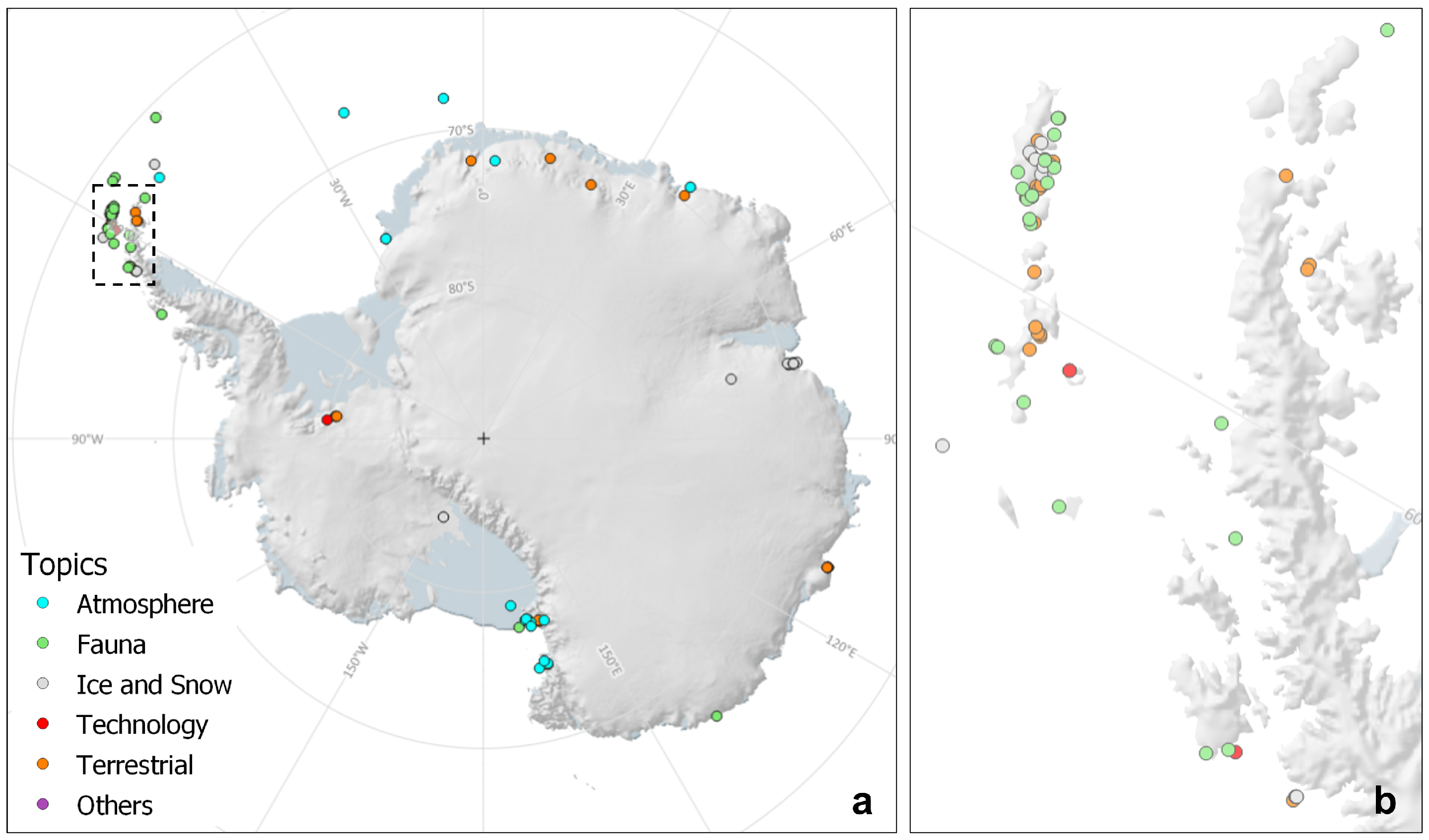
Figure 3.
Number of authors in papers about UAV applications in Antarctica.

Figure 4.
Female first authorship in publications in the period 2006–2021 (% of gender).

Figure 5.
Manufacturers of fixed-wing UAVs used in scientific papers about UAV applications in Antarctica.
Figure 5.
Manufacturers of fixed-wing UAVs used in scientific papers about UAV applications in Antarctica.

Figure 6.
Manufacturers of multi-rotor UAVs used in scientific papers about UAV applications in Antarctica.
Figure 6.
Manufacturers of multi-rotor UAVs used in scientific papers about UAV applications in Antarctica.

Figure 7.
Annual proportions of published papers by subject in the period 2006–2021, with the number of papers indicated in each coloured bar.
Figure 7.
Annual proportions of published papers by subject in the period 2006–2021, with the number of papers indicated in each coloured bar.


Table 1.
Type of publication of scientific papers about UAV applications in Antarctica.
| Publication Type | Number | % |
|---|---|---|
| Journal | 147 | 77.4 |
| Proceedings | 36 | 18.9 |
| Book chapter | 5 | 2.6 |
| Magazine | 2 | 1.1 |
Table 2.
Main topics of scientific papers about UAV applications in Antarctica.
| Topic | Number | % |
|---|---|---|
| Terrestrial | 54 | 28.4 |
| Ice and Snow | 45 | 23.7 |
| Fauna | 39 | 20.5 |
| Technology | 27 | 14.2 |
| Atmosphere | 20 | 10.6 |
| Others | 5 | 2.6 |
| Total | 190 |
Table 3.
Gender of the 1st author of each publication.
| Topic | Male (M) | Female (F) | % M-F |
|---|---|---|---|
| Terrestrial | 45 | 9 | 83-17 |
| Ice and Snow | 31 | 14 | 69-31 |
| Fauna | 27 | 12 | 69-31 |
| Technology | 27 | 0 | 100-0 |
| Atmosphere | 10 | 10 | 50-50 |
| Others | 5 | 0 | 100-0 |
| Total | 145 | 45 | 76-24 |
Table 4.
Number of publications by continental region and country of the institution of the first author in scientific papers about UAV applications in Antarctica.
Table 4.
Number of publications by continental region and country of the institution of the first author in scientific papers about UAV applications in Antarctica.
| Continent | Countries |
|---|---|
| Africa (1) | South Africa (1) |
| America (49) | United Sates of America (38), Brazil (3), Chile (3), Colombia (2), Canada (1), Mexico (1) and Peru (1) |
| Asia (31) | China (13), Japan (13) and South Korea (5) |
| Europe (87) | Poland (20), Russia (18), Germany (13), United Kingdom (12), Portugal (4), Czech Republic (3), Latvia (3), Spain (3), France (2), Ukraine (2), Austria (1), Denmark (1), Finland (1), Italy (2), Norway (1) and Switzerland (1) |
| Oceania (22) | Australia (15) and New Zealand (7) |
Table 5.
Multi-country authorship by paper about UAV applications in Antarctica (% in brackets).
| Topic | Number of Countries | |||
|---|---|---|---|---|
| 1 | 2 | 3 | 4 | |
| Terrestrial | 38 (71.7) | 12 (22.6) | 2 (3.8) | 1 (1.9) |
| Ice and Snow | 33 (73.3) | 7 (15.6) | 5 (11.1) | - |
| Fauna | 29 (72.5) | 6 (15.0) | 2 (5.0) | 3 (7.5) |
| Technology | 26 (96.3) | 1 (3.7) | - | - |
| Atmosphere | 11 (55.0) | 5 (25.0) | 3 (15.0) | 1 (5.0) |
| Others | 4 (80.0) | 1 (20.0) | - | - |
| Total | 141 (74.2) | 32 (16.9) | 12 (6.3) | 5 (2.6) |
Table 6.
Terrestrial applications using UAVs in Antarctica (54 papers).
| Main Topic | Specific Topic | References |
|---|---|---|
| Vegetation (20) | Mapping | Lucieer et al. (2010) [28], Lucieer et al. (2011) [29], Turner et al. (2012) [30], Lucieer et al. (2012) [31], Lucieer et al. (2014) [32], Lucieer et al. (2014) [33], Bollard-Breen et al. (2015) [34], Putzke et al. (2020) [35], Kim et al. (2020) [36], Sotille et al. (2020) [37], Váczi et al. (2020) [38], Câmara et al. (2021) [39], Bollard et al. (2022) [40] |
| Health assessment | Turner et al. (2014) [41], Malenovský et al. (2015) [42], Malenovský et al. (2017) [43], Turner et al. (2018) [44], Turner et al. (2019) [45] | |
| Change detection | Miranda et al. (2020) [46], Levy et al. (2020) [47] | |
| Landforms (18) | Moraines and glacier fronts | Westoby et al. (2015) [48], Westoby et al. (2016) [49], Woodward et al. (2022) [50], Akçar et al. (2020) [51], Kreczmer et al. (2021) [52] |
| Patterned ground | Pina et al. (2019) [21], Pereira et al. (2020) [53] | |
| Other | Hein et al. (2016) [54], Hein et al. (2016) [55], Dąbski et al. (2017) [56], Zmarz et al. (2018) [57], Dąbski et al. (2020) [58], Kňažková et al. (2021) [59], Ponti et al. (2020) [60] | |
| Soils | Mergelov et al. (2020) [61], Weisleitner et al. (2020) [62], Gyeong et al. (2021) [63], Abakumov et al. (2021) [64] | |
| Basemaps (12) | Mosaics and DEM | Bandeira et al. (2014) [65], Suganuma et al. (2016) [66], Suganuma et al. (2017) [67], Park et al. (2014) [68], Lamsters et al. (2020) [69], Coronado-Hernández et al. (2020) [22], Tabares (2021) [70], Liu et al. (2021) [71], Kuznetsova et al. (2021) [72], Tovar-Sánchez et al. [73], Faucher et al. (2021) [74], Chen et al. (2021) [75] |
| Geophysics (3) | Magnetic anomalies | Funaki et al. (2013) [76], Funaki et al. (2014) [77], Catalán et al. (2014) [78] |
| Algorithms (1) | Image processing | Acuña et al. (2016) [23] |
Table 7.
Ice and snow applications using UAV in Antarctica (45 papers).
| Main Topic | Specific Topic | References |
|---|---|---|
| Glacier ice (34) | Topography | Popov et al. (2017a) [79], Bliakharskii et al. (2018) [80], Bliakharskii et al. (2019) [81], Karušs et al. (2019) [82], Lamsters et al. (2019) [83], Cárdenas et al. (2020) [84], Florinsky et al. (2020) [85], Yuan et al. (2020) [86], Li et al. (2021) [87], He et al. (2021) [88] |
| Ice-sheets and glaciers | Pudełko et al. (2018) [89], Wójcik et al. (2019) [90], Wójcik-Długoborska and Bialik (2021) [91], Marusazh et al. (2019) [92], Marusazh (2020) [93], Osińska et al. (2021) [94], Alvarez et al. (2021) [95] | |
| Subsidence | Popov et al. (2017b) [96], Florinsky et al. (2019a) [97], Zhang et al. (2019) [98], Li et al. (2020) [99], Skrypitsyna et al. (2021) [100] | |
| Crevasses | Florinsky et al. (2018) [101], Florinsky et al. (2019b) [102], Bliakharskii et al. (2020) [103], Ishalina et al. (2020) [104], Ishalina et al. (2021) [105] | |
| Mapping | Markov et al. (2019) [106], Zhuravskiy et al. (2019) [107], Zhuravskiy et al. (2020) [108], Grigoreva et al. (2021) [109] | |
| Thickness | Leuschen et al. (2014) [110], Bello et al. (2020) [111], Arnold et al. (2020) [112] | |
| Sea-ice (6) | Topography | Williams et al. (2018) [113], Li et al. (2019) [114] |
| Icebergs | McGill et al. (2011) [115], Guant et al. (2021) [116] | |
| Pancake-ice | Williams et al. (2016) [117] | |
| Production | Ackley et al. (2020) [118] | |
| Snow (5) | Surface/depth | Tan et al. (2018) [119], Tan et al. (2020) [120], Tan et al. (2021) [121], Hrbáček et al. (2021) [122], Tarca et al. (2022) [123] |
Table 8.
Fauna applications using UAVs in Antarctica (39 papers).
| Main Topic | Specific Topic | References |
|---|---|---|
| Counting (22) | Penguins | Gardner et al. (2011) [124], Zmarz et al. (2015) [125], Hodgson et al. (2016) [126], Borowicks et al. (2018) [127], Korczak-Abshire et al. (2019) [128], Pfeifer et al. (2019) [129], Bird et al. (2020) [130], Shah et al. (2020) [131], Strycker et al. (2020) [132], Herman et al. (2020) [133], Strycker et al. (2021) [134], Liu et al. (2020) [135], Dunn et al. (2021) [136] |
| Seals | Mustafa et al. (2019) [137], Fudala and Bialik (2020) [138], Hyun et al. (2020) [139], Dickens et al. (2021) [140], Krause and Hinke (2021) [141] | |
| Flying birds | Oosthuizen et al. (2020) [142], Pfeifer et al. (2021) [143], Fudala and Bialik (2022) [144] | |
| Morphometrics (5) | Seals | Goebel et al. (2015) [145], Krause et al. (2017) [146] |
| Whales | Durban et al. (2021) [147], Gough et al. (2021) [148], Bierlich et al. (2021) [149] | |
| Mapping (1) | Guano stains | Firla et al. (2019) [150] |
| Interaction (11) | Disturbance | Korczak-Abshire et al. (2016) [151], Rümmler et al. (2016) [152], Rümmler et al. (2018) [153], Weimerskirch et al. (2018) [154], Mustafa et al. (2018) [155], Laborie et al. (2021) [156], Krause et al. (2021) [157], Rümmler et al. (2021a) [158], Rümmler et al. (2021b) [159] |
| Behaviour | Johnston (2019) [160], Bouchard et al. (2019) [161] |
Table 9.
Technology of UAVs in Antarctica (27 papers).
| Main Topic | Specific Topic | References |
|---|---|---|
| Platforms (10) | Design | Chen et al. (2009) [162], Agte et al. (2012) [163], Goraj (2014) [164], Goetzendorf-Grabowski and Rodzewicz (2017) [165], Rodzewicz et al. (2018) [166] |
| Development | Funaki et al. (2006) [18], Higashino et al. (2007) [167], Funaki et al. (2008) [168], Liang et al. (2008) [169], Garcia and Keshmiri (2013) [170] | |
| Sensors (5) | Design and development | Blake et al. (2008) [171], Lewis et al. (2009) [172], Crocker et al. (2012) [173], Uribe et al. (2014) [174], Tan et al. (2017) [175] |
| Testing (12) | Simulations and field trials | Lan et al. (2012) [176], Higashino and Funaki (2013) [177], Higashino et al. (2013) [19], Smith et al. (2015) [178], Keane et al. (2017) [179], Rodriguez-Morales et al. (2017) [180], Rodzewicz et al. (2017) [181], Mckinnis et al. (2020) [182], Inoue and Sato (2022) [183] |
| Control and Navigation | Lei et al. (2011) [184], Glowacki et al. 2015 [185] | |
| Fatigue evaluation | Rodzewicz et al. (2020) [20] |
Table 10.
Atmosphere applications using UAVs in Antarctica (20 papers).
| Main Topic | Specific Topic | References |
|---|---|---|
| Measurements (12) | Meteorology | van den Kroonenberg et al. (2007) [186], van den Kroonenberg et al. (2008) [187], van den Kroonenberg et al. (2008) [188], Knuth et al. (2011) [189], Knuth et al. (2013) [190], Cassano et al. (2014) [191], Jonassen et al. (2015) [192], Wille et al. (2017) [193], Lampert et al. (2020) [194], Sun et al. (2020) [195], Cassano et al. (2021) [196], Kremser et al. (2021) [197] |
| Air-surface coupling (5) | Polynya | Cassano et al. (2010) [198], Knuth et al. (2014) [199], Wenta and Cassano (2020) [200] |
| Sea-ice | Cassano et al. (2016) [201] | |
| Nunataks | Stenmark et al. (2014) [202] | |
| Sampling (3) | Aerosols | Higashino et al. (2014) [203], Higashino et al. (2021) [204], Higashino et al. (2021) [205] |
Table 11.
Other topics related to the use UAVs in Antarctica (5 papers).
| Main Topic | Specific Topic | References |
|---|---|---|
| Legislation (1) | Legal implications | Leary et al. (2017) [206] |
| Guidelines (2) | Operations | Ratcliff et al. (2015) [207] and Harris et al. (2019) [208] |
| User surveys (1) | GNSS | Sheridan (2020) [209] |
| Support to logistics (1) | Field expeditions | Li et al. (2021) [210] |
Table 12.
Types of UAV used in Antarctica by application topic in number (% in brackets).
| UAV Type | Total | Terrestrial | Ice-Snow | Fauna | Technology | Atmosphere | Others |
|---|---|---|---|---|---|---|---|
| Fixed-wing | 97 (51.1) | 22 (40.7) | 25 (55.6) | 10 (25.2) | 23 (85.2) | 17 (85.0) | - |
| Multi-rotor | 74 (38.9) | 27 (50.0) | 17 (37.8) | 26 (66.7) | 2 (7.4) | 1 (5.0) | 1 (20.0) |
| Both | 8 (4.2) | - | 2 (4.4) | 2 (5.1) | - | 2 (10.0) | 2 (40.0) |
| Unspecified | 6 (3.2) | 4 (7.4) | 1 (2.2) | 1 (2.6) | - | - | - |
| Not used | 5 (2.6) | 1 (1.9) | - | - | 2 (7.4) | - | 2 (40.0) |
| Total | 190 | 54 | 45 | 39 | 27 | 20 | 5 |
Publisher’s Note: MDPI stays neutral with regard to jurisdictional claims in published maps and institutional affiliations. |
© 2022 by the authors. Licensee MDPI, Basel, Switzerland. This article is an open access article distributed under the terms and conditions of the Creative Commons Attribution (CC BY) license (https://creativecommons.org/licenses/by/4.0/).
Share and Cite
MDPI and ACS Style
Pina, P.; Vieira, G. UAVs for Science in Antarctica. Remote Sens. 2022, 14, 1610. https://doi.org/10.3390/rs14071610
AMA Style
Pina P, Vieira G. UAVs for Science in Antarctica. Remote Sensing. 2022; 14(7):1610. https://doi.org/10.3390/rs14071610
Chicago/Turabian StylePina, Pedro, and Gonçalo Vieira. 2022. "UAVs for Science in Antarctica" Remote Sensing 14, no. 7: 1610. https://doi.org/10.3390/rs14071610
Note that from the first issue of 2016, this journal uses article numbers instead of page numbers. See further details here.