1. Introduction
Accurate, large-area land cover maps are basic data support for exploring the relationship between natural and biological activities and spatial patterns [
1,
2]; the simulation, monitoring, and evaluation of ecological and environmental changes [
3]; human social and economic development [
4,
5]; and other scientific studies. Food security and arable land area assessment, forest change monitoring, urban extent expansion and structure analysis, and water body area extraction and pollution assessment also require timely updates of large thematic maps to provide important indicators for human sustainable development strategies [
6,
7]. With the development of remote sensing technology and the appearance of a variety of sources of satellite data, remote sensing has become an important method for mapping land cover over a large area [
8,
9].
Based on image data from NOAA/AVHRR, MODIS, ENXISAT/MERIS, and other satellite sensors, land cover products usually have a coarse spatial resolution (300–1000 m). For example, we have 500 m spatial resolution MODIS global land cover data from Boston University [
8]. The European Space Agency (ESA) ESA-CCI dataset has a 300 m spatial resolution [
10]. The Copernicus Global Land Service (CGLS) dataset has a 100 m spatial resolution [
11]. Previous research has shown that a lower spatial resolution usually leads to lower accuracy [
12,
13]. With the development of the Landsat series of satellites, the monitoring of a large area with medium-spatial-resolution land cover products became possible. For example, FROM-GLC, developed by Tsinghua University in China [
14], and GlobeLand30, developed by the National Basic Geographic Information Center of China, etc., have 30 m spatial resolution [
15]. In addition, there are a number of single-category land cover products, such as the Global Food Security support analysis data 30 m (GFSAD30) developed by USGS [
16], the Advanced Land Observing Satellite Phased Array L-band SAR (PALSAR) developed by the Japan Aerospace Exploration Agency (JAXA)) [
17], the Global Surface Water Explorer dataset [
18], etc. Different remote sensing images affect the spatial resolution of land cover data, and the spatial resolution restricts the level of detail of a land cover classification system [
19]. Consequently, due to different classification systems, classification methods, and types of satellite sensors, there is great inconsistency between multisource products. When multisource products are used in collaboration, it will lead to greater uncertainty [
16,
20].
Data fusion can overcome the limited accuracy and uncertainty associated with single data sources by integrating multisource data [
21,
22]. Some fusion decision methods, such as the Bayesian theory, Dempster–Shafer evidence theory, and fuzzy set theory have been effectively applied in numerous studies [
20,
23,
24]. Several studies have introduced multisource statistics to calibrate fused products, which can improve the accuracy of fusion results. The accuracy of the original products significantly affects the fusion results [
25,
26], such that, as input products increase, the weights of the products are determined with a priori knowledge; otherwise, it is difficult to obtain good results [
27]. Due to the above limitations of fusion decision methods, researchers selected samples from previous surface coverage products to update maps. For example, the U.S. Geological Survey (USGS) proposed spectral change monitoring methods to identify nonchange areas and used these areas as samples to train decision tree classifiers that can rapidly update land cover maps [
28]. However, information obtained from a single source of surface coverage products is often less reliable than the fusion of multiple products [
21].
Multisource data fusion often requires resampling to unify spatial resolution and obtain consistent areas [
16]. Consistent areas are defined as areas in which a variety of land cover products remain in the same category at the same geographical location [
29]. We can usually have a high level of confidence in the information retained about each ground cover product [
27]. Therefore, extracting effective information from the consistent areas of multi-source products and correcting the inconsistent areas is considered a fusion method to effectively improve mapping accuracy [
30]. However, due to resampling, the final result will still have a coarse spatial resolution.
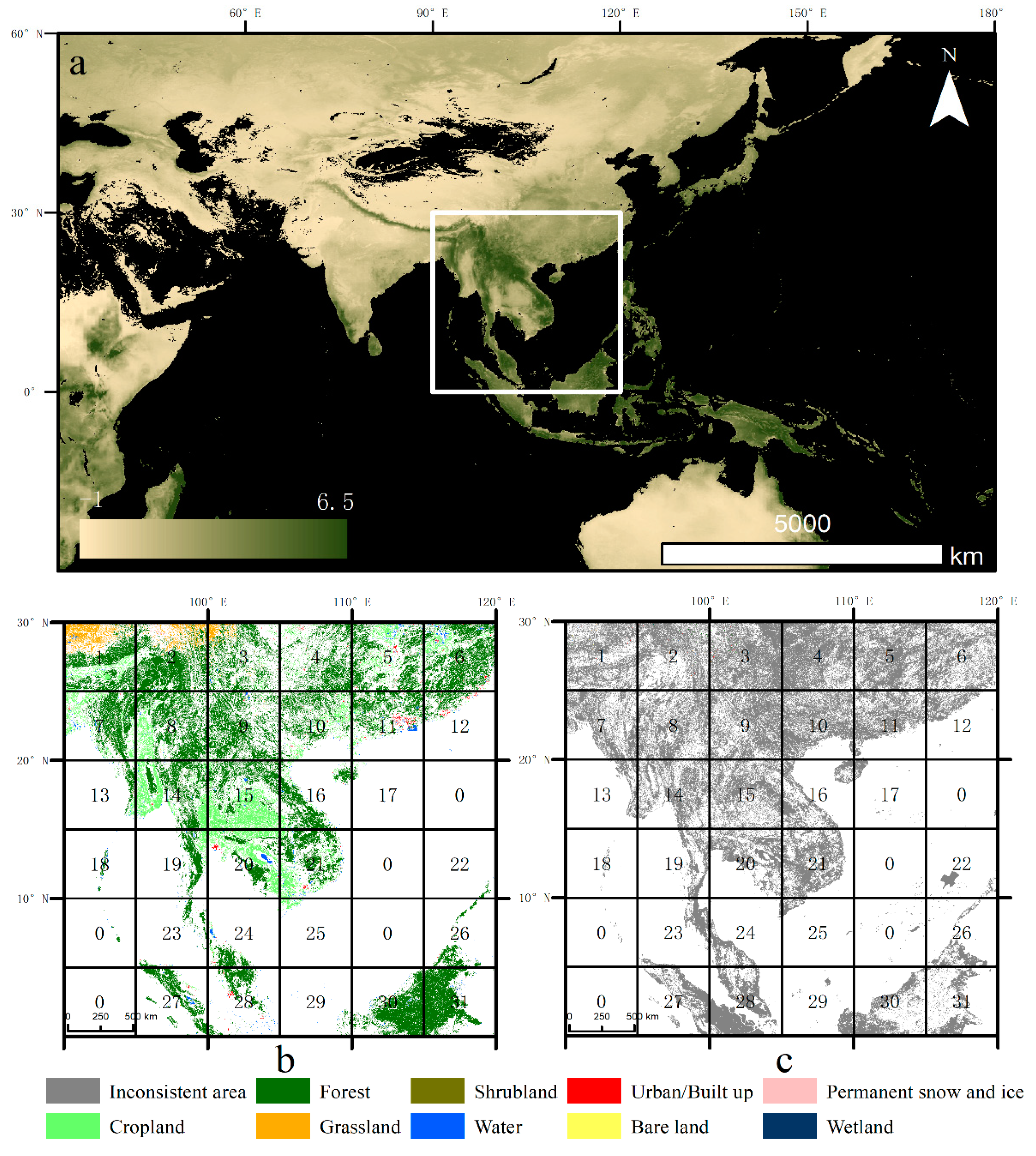
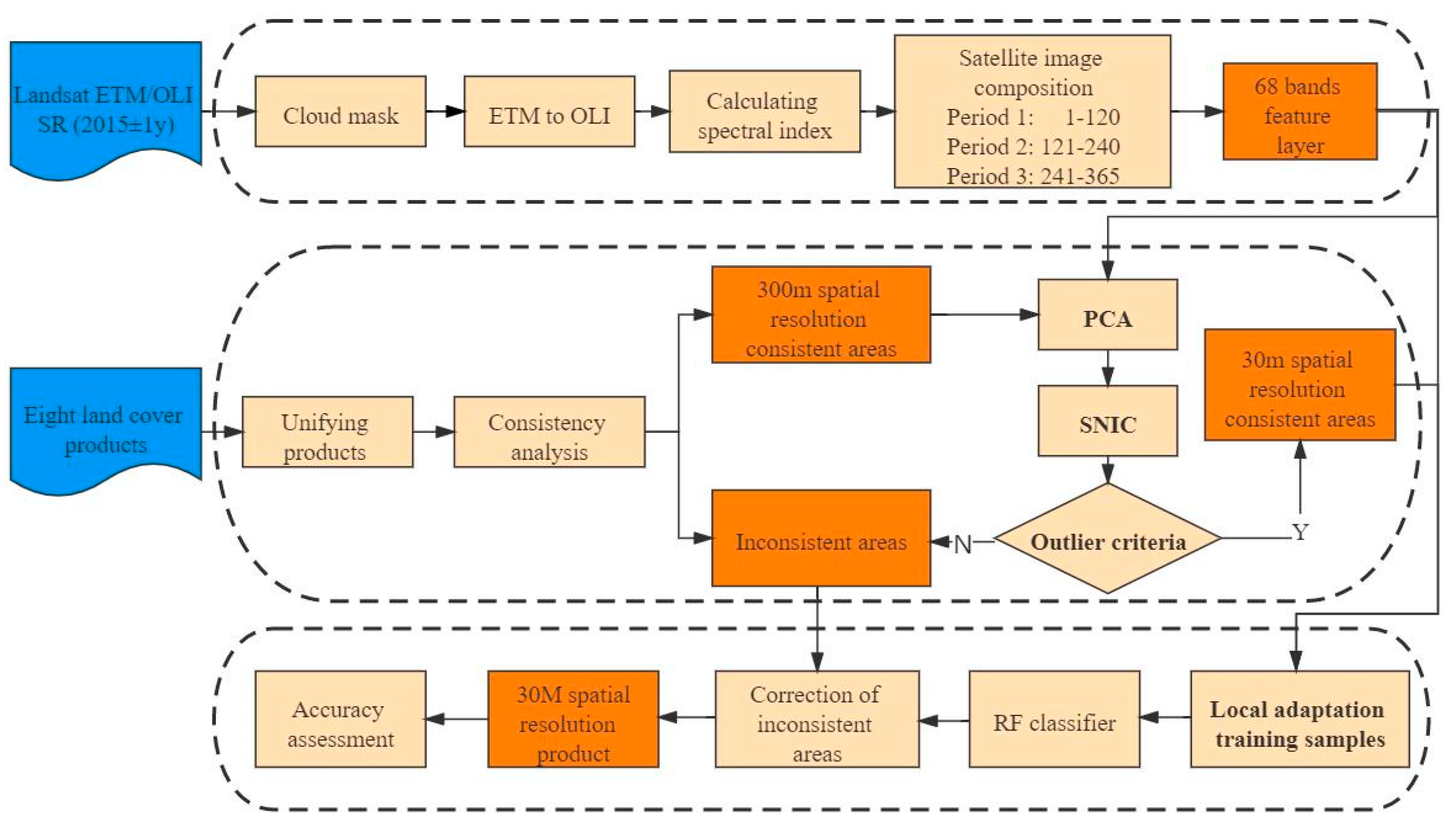
To solve the above problems, we base this study on an existing method [
31] and further propose a multisource land cover products fusion method based on superpixels and statistical extraction that achieves fine spatial resolution and high-accuracy fusion results. In the first step, we analyze the consistency of multiple products to divide the study area into 300 m spatial resolution (coarse) consistent areas and inconsistent areas and compose a 30 m feature image layer on the GEE platform. In the second step, the PCA and SNIC (simple noniterative clustering) algorithm is used to segment the image in the coarse consistent areas, remove outlying pixels, and obtain 30 m spatial resolution (fine) consistent areas. In the third step, we obtain reliable training samples by the local adaptation sampling method and correct inconsistent areas by machine learning to generate fine spatial resolution and high-precision fusion results. Then, we apply and verify the proposed method with the example of southeast Asia.
5. Discussion
To solve the problem that the fusion result cannot achieve fine spatial resolution due to resampling in previous fusion methods [
27,
29,
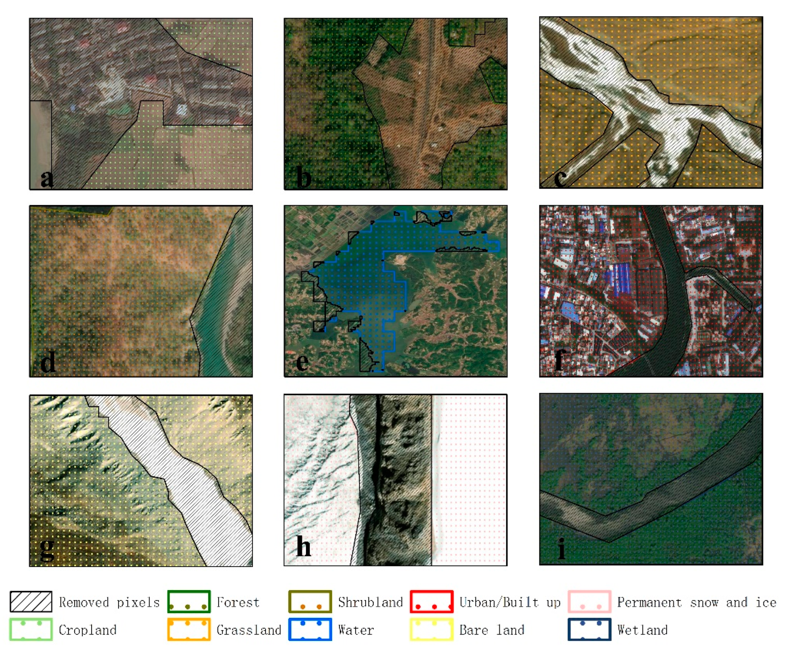
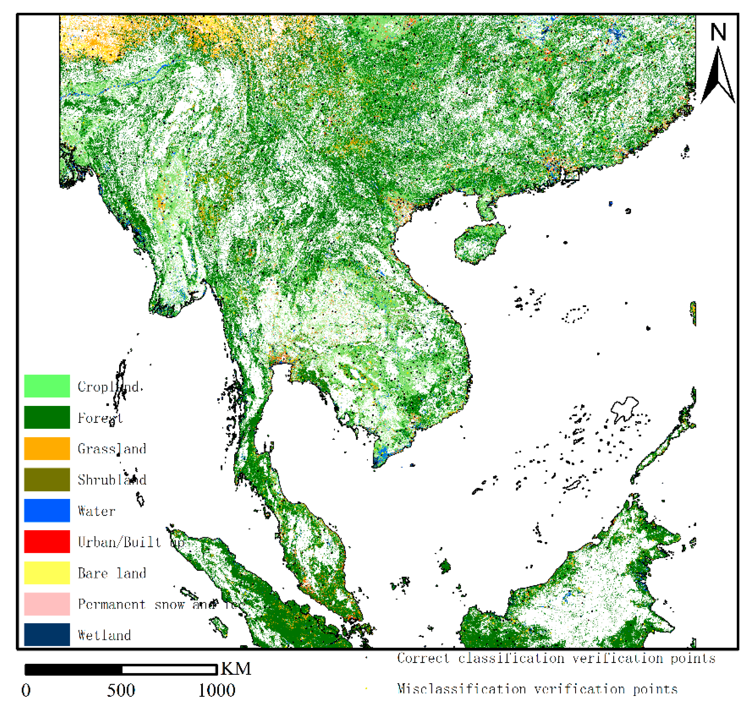
30], this study developed a multisource land cover products fusion method based on the SNIC segmentation algorithm and the PCA technique. The results show that this fusion method can obtain fusion results with fine spatial resolution and improve the accuracy of inconsistent areas to various degrees. This method creatively uses the SNIC segmentation algorithm to segment Landsat image layers in the coarse consistent areas into pixel groups, and outlier pixel groups were removed by PCA and statistical methods. Therefore, coarse consistent areas can be purified into fine consistent areas, and the spatial resolution has also been increased by 30 m from 300 m. This has never been done in previous studies. The results showed that 38.75% of pixels were removed in the coarse consistent areas. In addition, most of the pixels that were removed were wrongly marked because they were ignored during resampling (
Figure 4). At the same time, the sample accuracy rate can reach 93.44% through sampling detection of fine consistent areas. The sample accuracy of RF in this study can be satisfied. Therefore, the method of SNIC and PCA proposed in this paper to improve the spatial resolution of fusion result is worthy of reference.
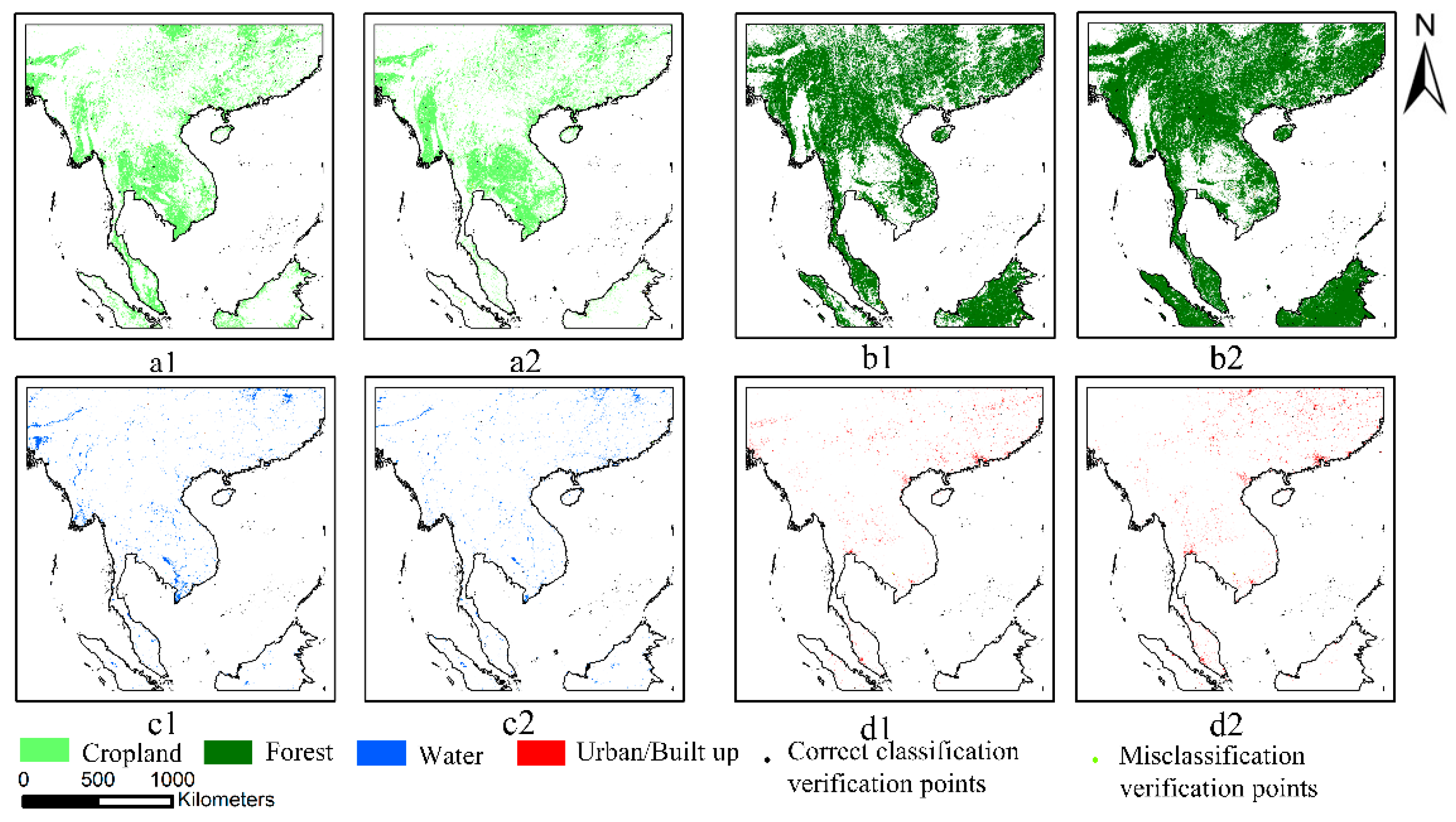
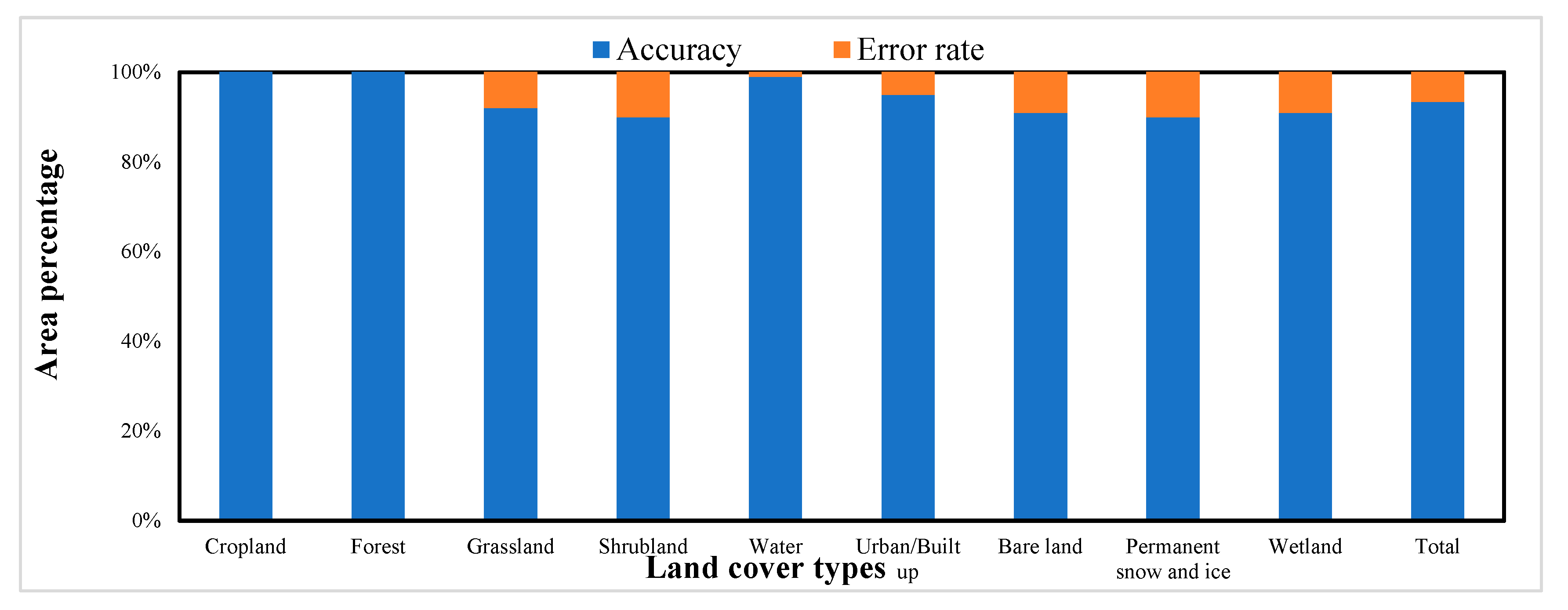
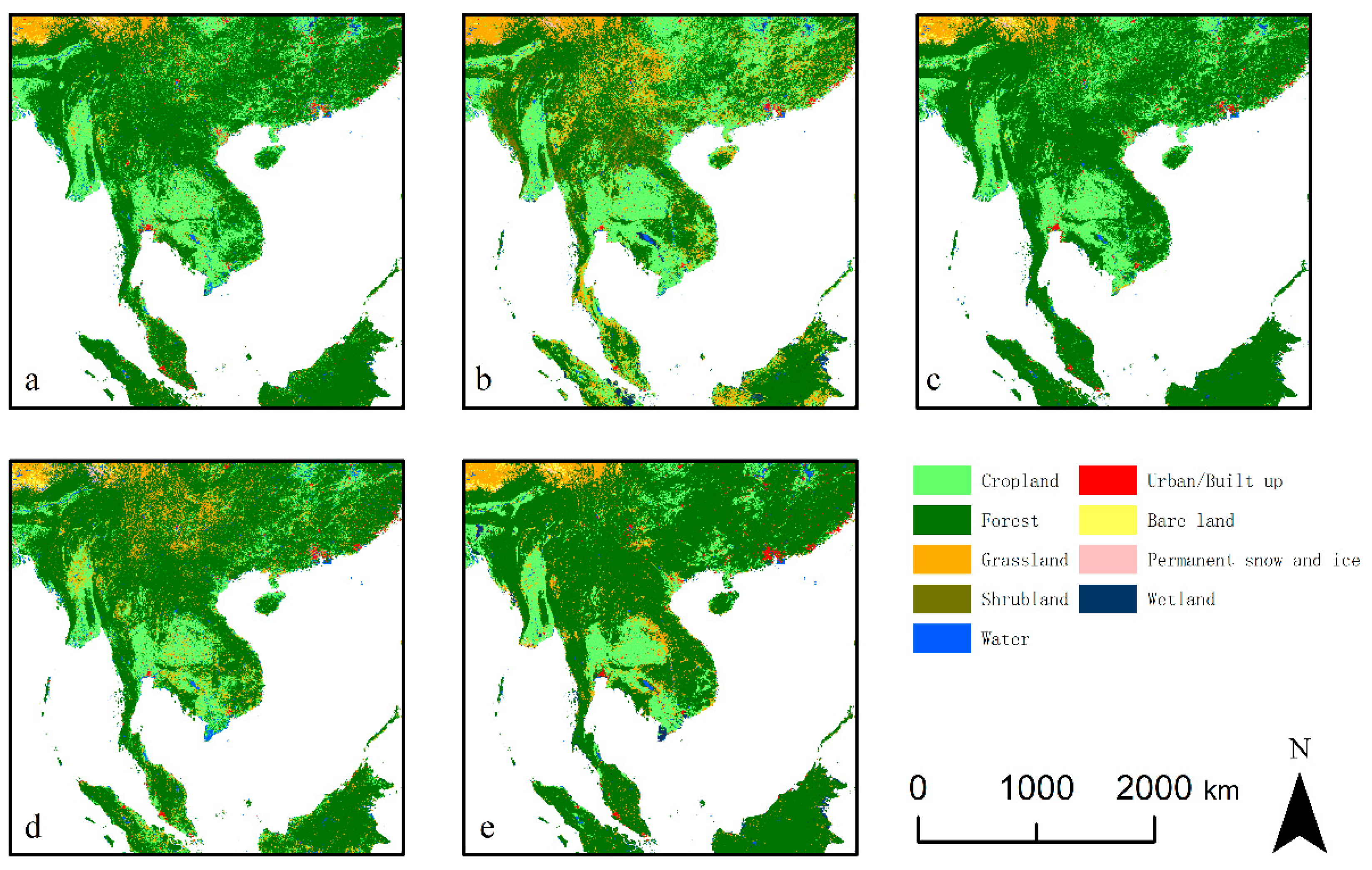
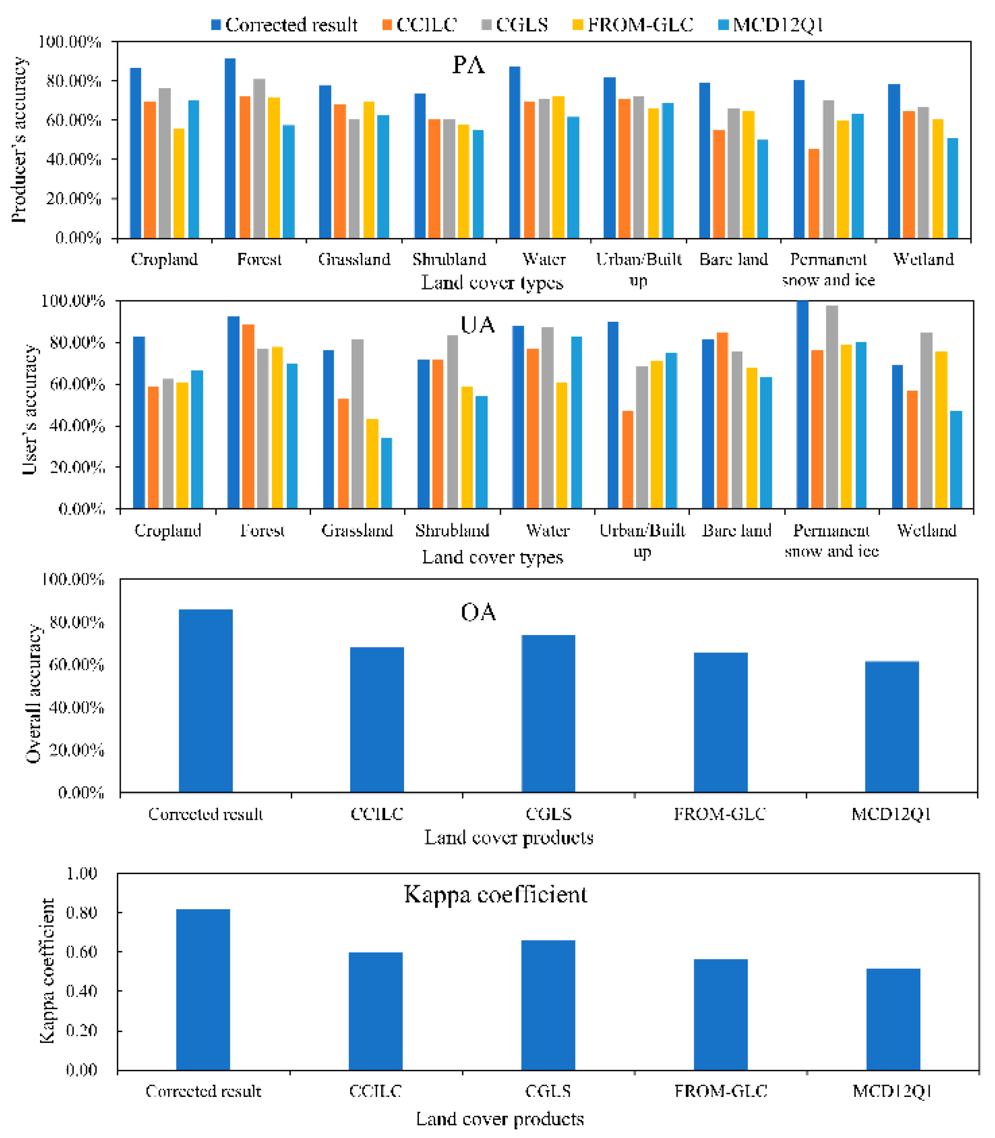
With the support of GEE’s massive dataset and a large number of sample points (more than 300,000) from the fine consistent areas, the inconsistent areas were recorrected. New fine spatial resolution fusion results were obtained. The results showed that, of the four available multicategory products, CCILC, CGLS, and MCD12Q1 have spatial resolutions below 30 m and provide significantly less information than the fusion results in this study. For the FROM-GLC with the same spatial resolution, our fusion results provide significantly higher accuracy in the inconsistent areas. The overall accuracy in the inconsistent areas can reach 85.80%, and the kappa coefficient can reach 0.82—an OA improvement of at least 11.75%, and at least 0.16 for the kappa coefficient. The overall accuracy can be improved by at least 2.99%, and the kappa coefficient can be improved by at least 0.22 compared to single-category products. Similar to other studies, this study also found an overinterpretation of a single category of products. Based on the confusion matrix of the validation points of a single category, other types in the inconsistent areas of a single category of products are easily overtranslated into this single type, which leads to excessive differences in the PA of the products compared to UA. The method used in this study corrects the problem of overinterpretation of a single product in the inconsistent area. Therefore, the fusion method provided in this study can effectively integrate multiple land cover products and correct uncertain information.
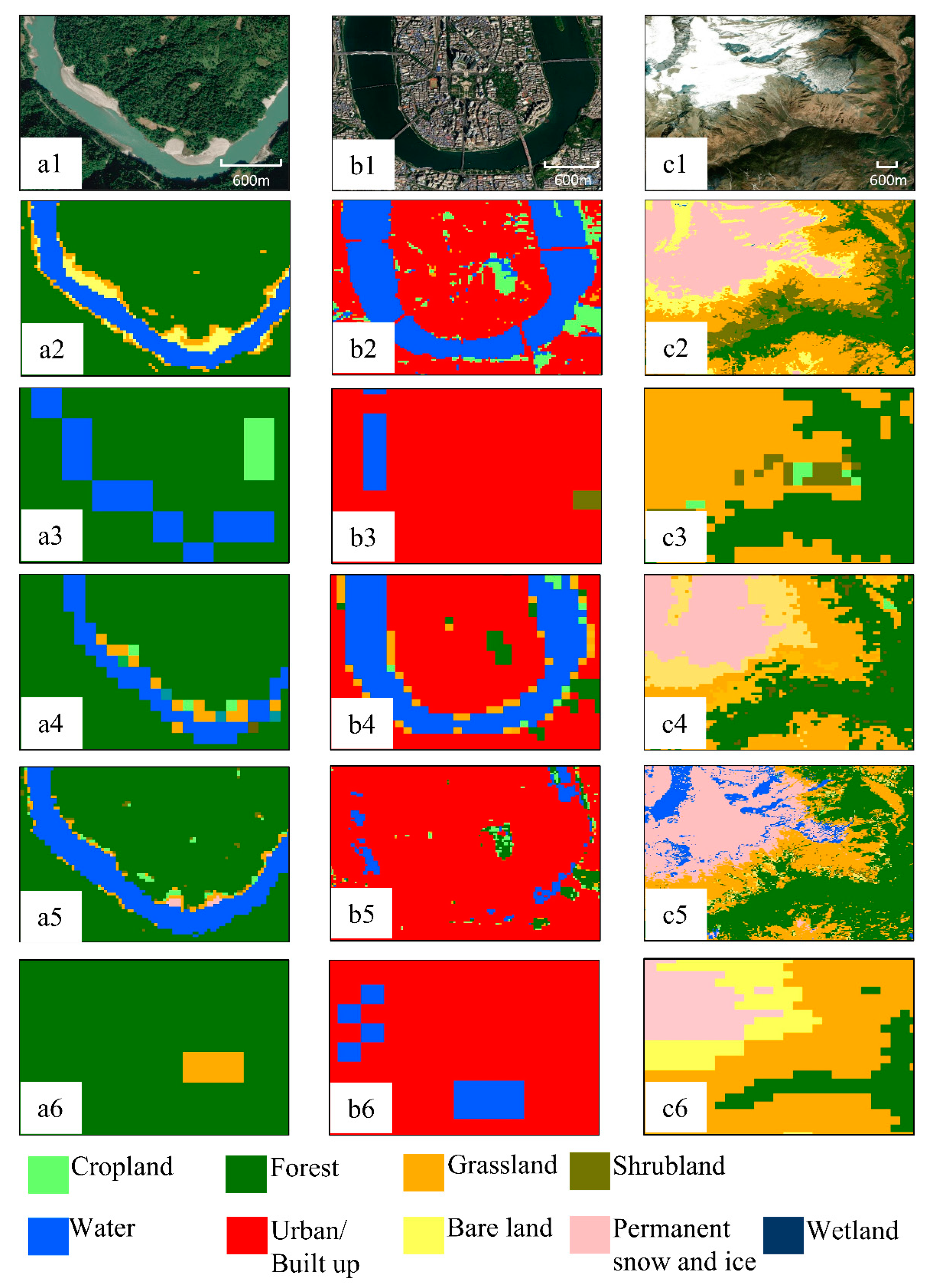
We found that cropland and grassland are prone to being confused for each other in multicategory land cover mapping, and shrubland is a transitional land cover type between grassland and bare land [
30]. Wetland is, inherently, a difficult land cover type to map, and wetland, cropland, and grassland are also prone to misclassification in wet locations [
52]. The spectral characteristics are very similar between these types, such that the accuracy of the grassland, shrubland, and wetland is relatively low in each product [
14]. Although our method can improve the mapping accuracy of these types in inconsistent areas, it is still difficult to achieve high accuracy, which must be noted in future studies to distinguish these types more accurately. Grassland, bare ground, and permanent snow and ice are distributed at high latitudes and high altitudes and are often mistaken for each other due to the melting snow and ice caused by seasonal changes [
65,
66], which also requires attention in future studies.
Although our method can integrate valid information from multiple land cover products and significantly improve accuracy, there are still some aspects that can be improved and should continue to be investigated in the future, considering the problems in the current method. The method proposed in this paper needs to be carried out under the condition that there are many land cover data of the same year, and remote sensing images are fully covered. The land cover products selected in this study are from 2015 and can cover the study area with only Landsat images with 30 m spatial resolution. With the updating of land cover data and open access to high-resolution remote sensing images, such as the Sentinel 2 and GF series, the method proposed in this paper is still applicable and obtains spatial higher resolution land cover fusion products. However, there are some problems and possibilities for improvement. First, large-area, high-spatial-resolution image segmentation is a challenge, and ensuring accurate segmentation and operation efficiency is a problem to be solved. Second, research shows that a data cube can solve the problem of insufficient global remote sensing data coverage, so the method proposed in this paper can also use a data cube to obtain land cover products with high time frequency [
66]. Finally, deep learning has shown excellent potential in remote sensing in recent years [
67], and fusion and prediction of more accurate information through deep learning compared to traditional models will also be our future direction.
6. Conclusions
In this study, we proposed a multisource land cover products fusion method based on the SNIC segmentation algorithm and PCA technique. The method can solve the problem of fusion results not achieving fine spatial resolution due to resampling in previous fusion methods. It creatively used the SNIC segmentation algorithm to segment Landsat image layers in coarse consistent areas into pixel groups, and outlier pixel groups were removed by PCA and statistical methods. Then, fine consistent areas were obtained. The proposed method was applied and validated with the sample points of Google Earth, and the results showed an accuracy of 93.44% for extracting training samples from the fine consistent areas. This indicates that the proposed method is fully capable of providing numerous accurate samples. In this study, the overall accuracy of the fusion result in the inconsistent area was 85.80%, which is an improvement of 11.75– 24.17% compared with the existing multicategory land cover products of CCI-LC, CGLS, FROM-GLC, and MCD12Q1. The kappa coefficient was 0.82, which is an improvement of 0.16–0.3. Compared with four single-category products, GFSAD30, PLASAR, GWSD, and GHS-BUILT, our fusion results can improve the overall accuracy by 2.99–20.71% and the kappa coefficient by 0.22–0.56 and can correct the overinterpretation in inconsistent areas for single-category products. Therefore, our method is proven to be effective and, in the future, under the condition of complete coverage of high-spatial-resolution remote sensing images, can rapidly obtain high-accuracy and fine-spatial-resolution land cover fusion results over a large area.


