1. Introduction
Glaciers are an important component of the Tibetan Plateau, the “water tower of Asia”, and are of great importance to regional climate and hydrology, as well as to global ecological changes [
1,
2,
3,
4]. Climate change has already led to glacier shrinkage on the Tibetan Plateau and surrounding areas, but the rate of glacier shrinkage varies between regions [
5,
6,
7,
8].
Glaciers in many sub-regions of the Tibetan Plateau are shrinking rapidly, such as the Himalayas, Nyainqentangula, Altai Mountain, the central and eastern Tianshan Mountains [
9], etc. There are also some sub-regions where glaciers are shrinking slowly, such as Qiangtang Plateau, West Kunlun Mountain [
10,
11,
12], Pamirs Plateau, and West Tianshan Mountain. However, the area of glaciers in the Karakorum region is almost unchanged, that is, the phenomenon of the “Karakorum anomaly” (glaciers in the Karakorum moved forward at the end of the 20th century when glaciers were generally in retreat globally) [
13,
14]. Glacier variability is associated with changes in precipitation in the monsoon-dominated southeast and westerly-dominated northwest [
6]. Existing studies have focused on clean glaciers and ignored debris-covered glaciers generally. Climate change, however, may accelerate rock calving and increase the accumulation of debris on glaciers and mountain slopes, forcing geomorphic processes on alpine slopes. As a result, the mountain glaciers of the Pamir, Karakoram, Kunlun, Nyainqentangula, and Himalaya Mountains have extensive debris cover [
15,
16,
17,
18,
19]. The debris layer has unique thermal conductivity that results in different ablation processes in the underlying glacier [
20,
21], which affects the mass balance of the glacier and its meltwater runoff. Therefore, understanding the spatial and temporal distribution of clean and debris-covered glaciers on the Tibetan Plateau and their relationship with climate will not only improve the understanding of glaciers and their meltwater runoff but also contribute to the scientific formulation of measures to deal with climate change in the “Water Tower of Asia”.
At present, methods for extracting glaciers based on remote sensing information include the Normalized Difference Snow Index (NDSI) method [
22], the band ratio method [
23,
24], random forest (RF) supervised classification [
25,
26], etc. These methods can extract clean ice or snow with high accuracy, but it is difficult to extract debris-covered glaciers accurately because the spectral information of these debris-covered glaciers is very similar to that of rocks [
27,
28]. Therefore, some other parameters or methods are used to identify debris-covered glaciers, such as topographic parameters based on digital elevation models [
29,
30,
31,
32], thermal properties in the infrared band [
33,
34], unique velocity characteristics of glaciers [
35], and coherent changes in synthetic aperture radar (SAR) images [
36,
37,
38]. These parameters or methods have improved the accuracy of debris-covered glacier extraction to a certain extent, but they are difficult to apply on a large scale due to complex pre-processing and data limitations [
39]. The newly proposed double RF method [
40] can significantly improve the extraction accuracy of clean glaciers and debris-covered glaciers on the Tibetan Plateau. The method is based on Google Earth Engine (GEE) [
41,
42] and combines various classification features to extract different types of glaciers in steps by the random forest method, achieving accurate extraction of glaciers under the influence of shadows, snow, cloudiness, and debris [
40].
This study uses the double RF method to extract both clean and debris-covered glaciers on the Tibetan Plateau from 1985 to 2020 in a stepwise manner and then analyzes the spatial and temporal evolution characteristics of different types of glaciers. The results reveal the impact of climate change on the changes of different types of glaciers and provide a basis for scientific responses to climate change.
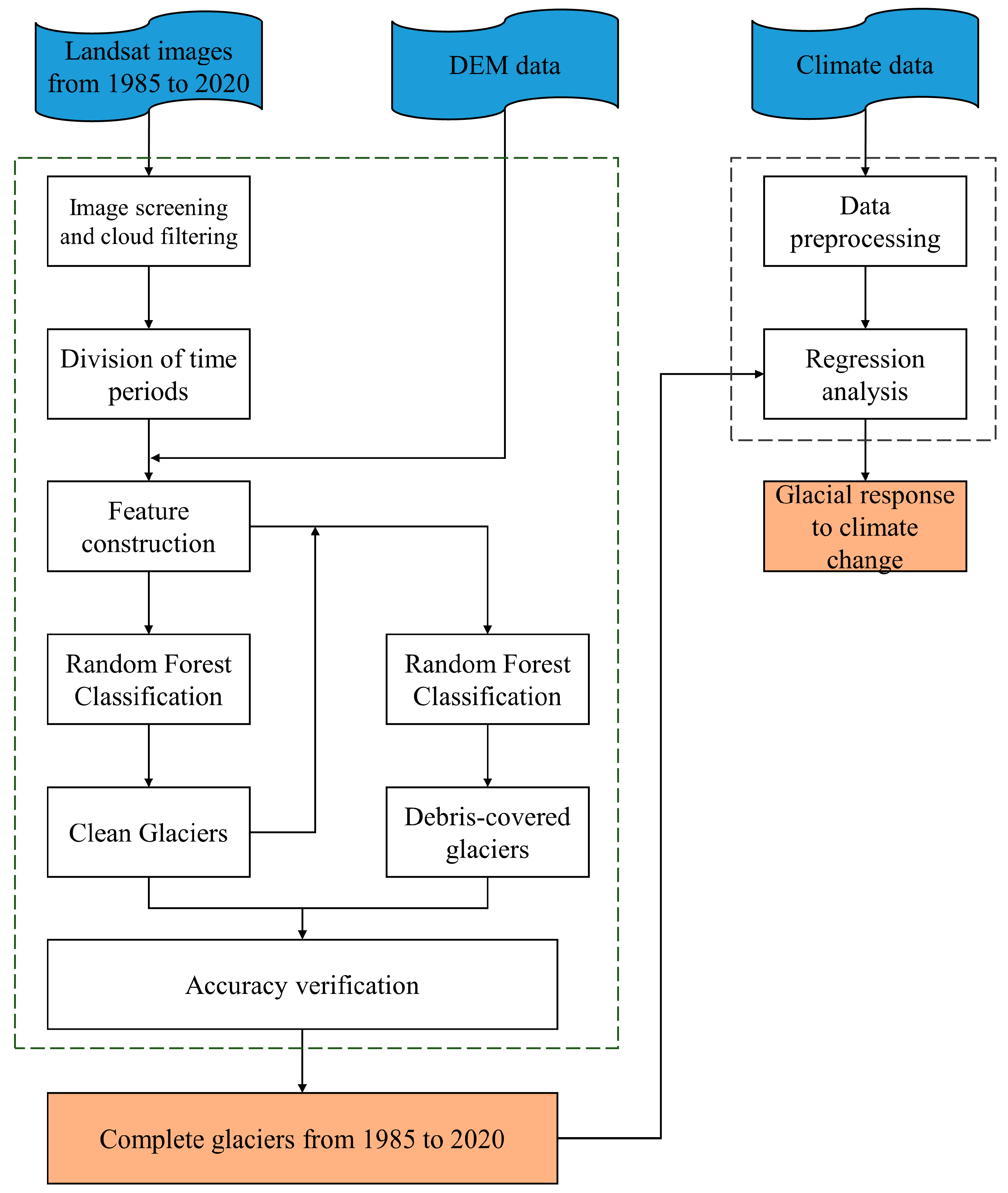
3. Method
In this study, both clean and debris-covered glaciers on the Tibetan Plateau from 1985 to 2020 were first extracted using the double RF method, then their spatial and temporal evolution characteristics were analyzed, and finally their responses to climate change were explored. The specific process is shown in
Figure 2.
3.1. Image Screening and Cloud Filtering
The conditions of image screening include geographical scope and time. In this study, the images of the Tibetan Plateau from June to October during the summer melting period from 1985 to 2020 were selected to reduce the influence of snowfall on glacier extraction.
The cloud scoring algorithm provided by GEE mainly uses cloud filter to calculate the cloud score of each pixel. The cloud score ranges from 0 (no clouds) to 100 (very thick clouds). The terrain of the Tibetan Plateau is very complex, with many areas covered by clouds all the year round. It is difficult to synthesize a complete map with only pixels with a cloud score of 0. Therefore, the threshold of cloud filtering score in this study was set to 60 points [
40].
3.2. Division of Time Period
The influence of cloud cover on the Tibetan Plateau makes it difficult to synthesize a complete image with few clouds and little snow using summer images of one year. Thus, this study divided 1985–2020 into several time periods and ensured that the synthetic images of each time period were relatively complete. Since 1985, we added images for one year at a time, then synthesized the images and calculated the empty pixel rate. The steps of image synthesis are shown in
Figure 3. When the empty pixel rate of the composite image was less than 1.5%, the division of a time period was completed. Finally, 11 complete images of less cloud and less snow on the Tibetan Plateau were obtained for the period 1985–2020 (
Table 1).
The images of each period were synthesized into a complete image of the Tibetan Plateau with less cloud and snow. This study found that the spectral characteristics of snow in the median composite image are very similar to those of clean glaciers but different from those of debris-covered glaciers. In the minimum composite image, there is almost no snow, but the debris glacier is indistinguishable from the surrounding rocks. Therefore, the minimum value of the pixel set was first used to synthesize images to minimize the influence of snow on the extraction of clean glaciers, and then the median value of the pixel set was to synthesize the images, so as to enhance the difference between the debris-covered glaciers and the surrounding rocks, thus accurately extracting the debris-covered glaciers. In this way, there were two images for glacier identification in each time period.
3.3. Feature Construction
According to the double RF method, the input features of the classifier included spectral features, texture, and topographic features. The spectral features included: raw spectra (B1-B7), normalized difference vegetation index (NDVI) [
48], normalized difference water index (NDWI) [
49], normalized difference snow index (NDSI) [
50], brightness, greenness, and humidity information after tassel cap transformation [
51], as well as the newly proposed band difference and multi-temporal minimum band ratio [
40]. Texture features included six common texture features based on band ratio images: angle second moment, contrast, correlation, variance, inverse different moment, and entropy [
52]. The topographic features included elevation, slope, and aspect, while the time period using Landsat 8 imagery also used the thermal infrared band (B10). The features constructed in this study are shown in
Table 2. These features have been shown to be appropriate for glacier classification on the Tibetan Plateau [
40].
3.4. Sample Point Selection
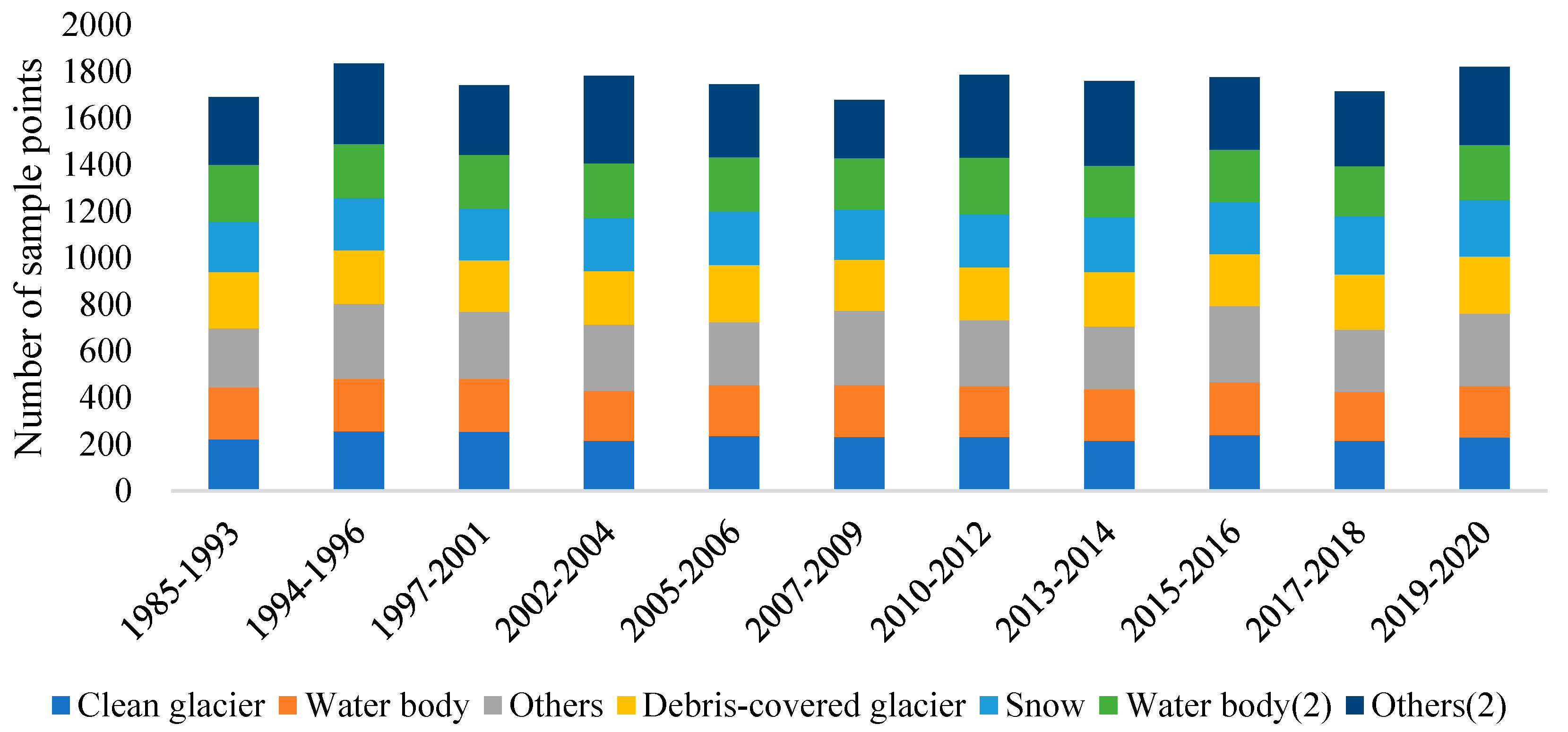
Default values were used for all parameters of the classifier. The classification samples were obtained by manual visual interpretation using synthetic images. In this study, clean glaciers, water bodies, and others were used for the first classification, while snow, debris-covered glaciers, water bodies, and others were used for the second classification. In the process of selecting sample points for each category, the principle of randomness and homogeneity was applied to try to have collections throughout the study area. The sample points for all time periods were selected as shown in
Figure 4.
3.5. Accuracy Validation
Common accuracy evaluation metrics include overall accuracy, kappa coefficient, producer accuracy, and user accuracy based on the classification confusion matrix [
53]. In this study, the total sample was divided into two parts using a cross-validation method, where 70% of the sample points from each category were randomly selected to train the model and 30% of the sample points were retained for validation to calculate the overall accuracy and kappa coefficient.
3.6. Post-Classification Processing
In the classification results of supervised classification, band ratio method or decision tree, there are inevitably some incorrectly classified noise points or small pixel patches, which brings some adverse effects on image quality and accuracy [
54,
55]. To eliminate this noise (small pixel patches), the initial classification results were filtered. In the first classification, small patches with less than 50 connected pixels were filtered out, and in the second classification, the patches with less than 100 connected pixels were filtered out and larger debris-covered glaciers were retained.
6. Conclusions
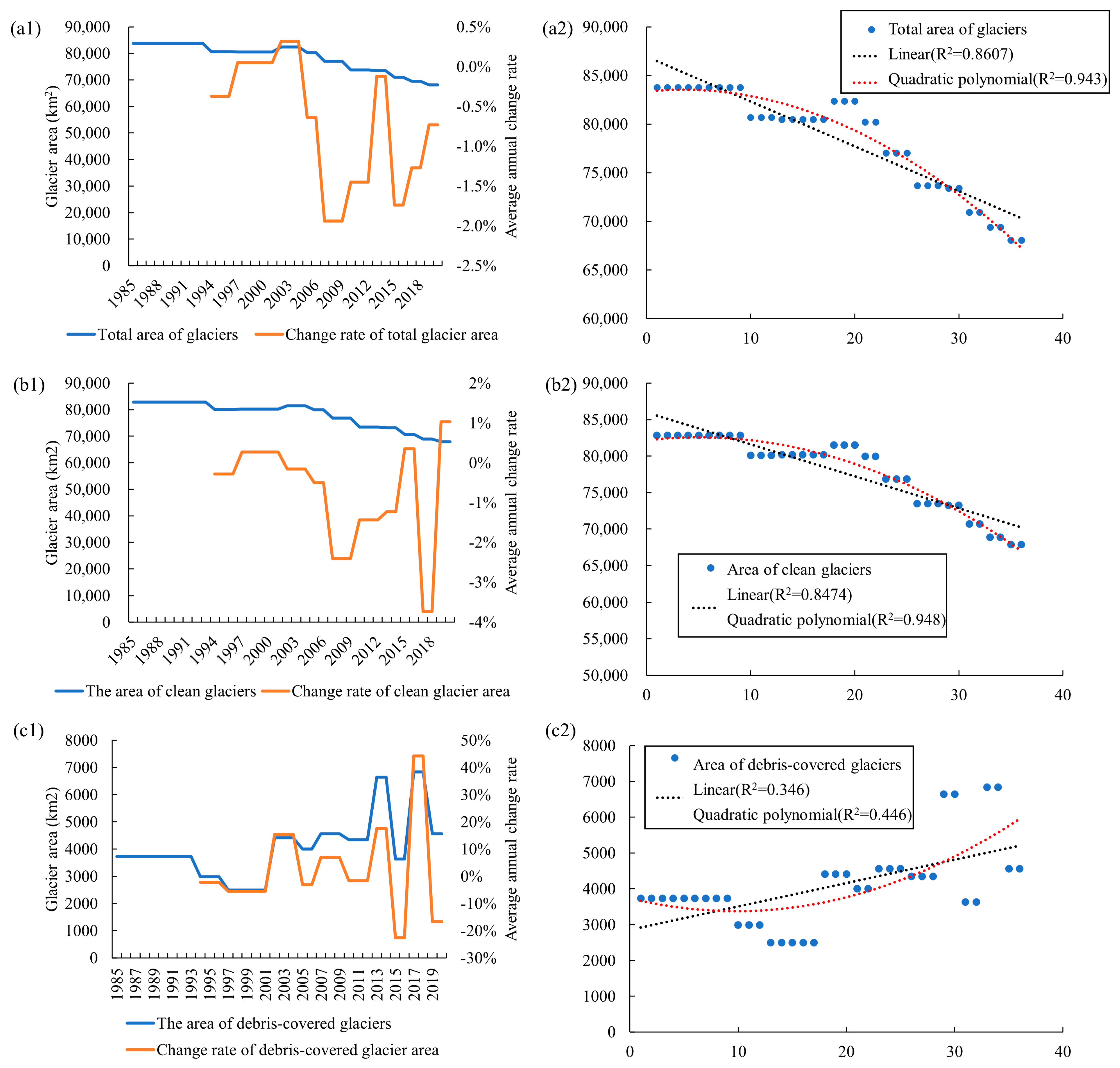
Extracting glaciers from remote sensing images is easily affected by mountain and cloud shadows, cloud cover, and seasonal snow cover. In this study, by counting the empty pixel rate of the composite image, 1985–2020 was divided into 11 periods, and then the clean glaciers and debris-covered glaciers of the 11 periods on the Tibetan Plateau were gradually extracted using the double RF method. The results show that the clean glaciers showed an obvious retreat trend, with an average retreat rate of −0.55% yr−1, while the area of debris-covered glaciers showed an expanding trend, with an expanding rate of 0.62 % yr−1 but with large variability in the rate of change over time.
According to the analysis of the evolution characteristics of glaciers on the Tibetan Plateau from different basins, elevations, slopes, and aspects, it is found that the clean glaciers were shrinking faster in the southeast and slower in the northwest, while the area of debris-covered glaciers in most basins was increasing. The distribution elevation of debris-covered glaciers was generally lower than that of clean glaciers. Both clean and debris-covered glaciers were constantly expanding to high altitudes. The slopes of clean glaciers were mainly 0–50°, while those of debris-covered glaciers were mainly 0–30°. There were fewer clean glaciers in the south or southwest slope, and more clean glaciers in the northeast slope, while debris-covered glaciers were more distributed in the northeast and southwest slope.
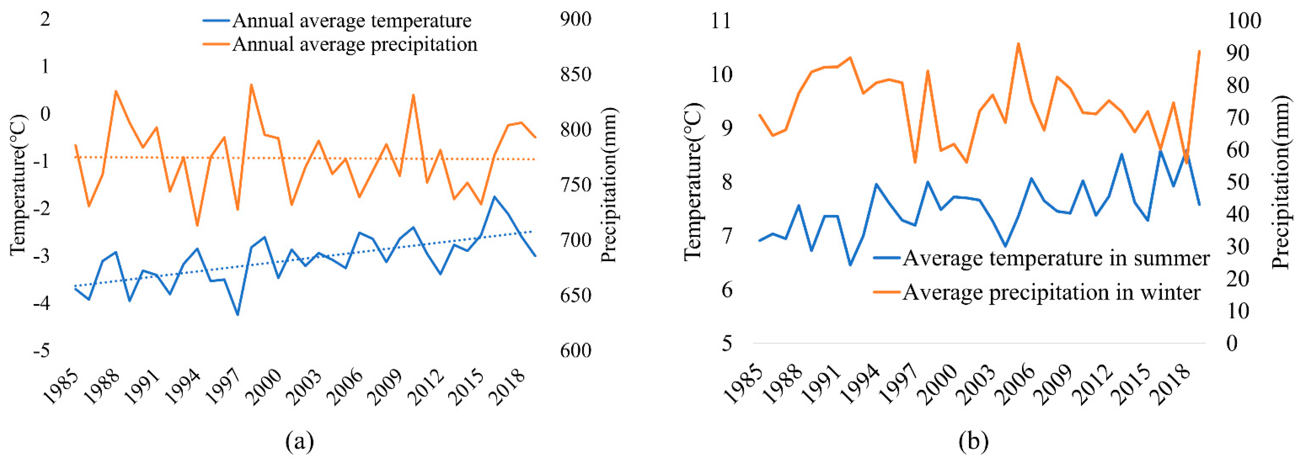
Climate warming was a main driver of glacier change. The clean glacier area was negatively correlated with the average temperature in summer and positively correlated with the average precipitation in winter, while the debris-covered glacier area was correlated positively with both.
With the global warming, more and more clean glaciers in Asian alpine areas have been transformed into debris-covered glaciers, which may greatly affect the water resources in the basin and its future trend. In the future, it is necessary to consider all the factors affecting glaciers, establish a general glacier model, reveal the relationship between glaciers and climate, and provide a theoretical basis for glacier change prediction and disaster prevention on the Tibetan Plateau as well as for the rational utilization of glacier melt water resources.


 ,
, 


