Study of a Steady-State Landscape Using Remote Sensing and Topographic Analysis
Abstract
1. Introduction
2. Study Area
3. Methods
3.1. Creating a Digital Elevation Model
3.2. Estimating River Incision Rates
3.3. Estimating Hillslope Erosion Rates
4. Results
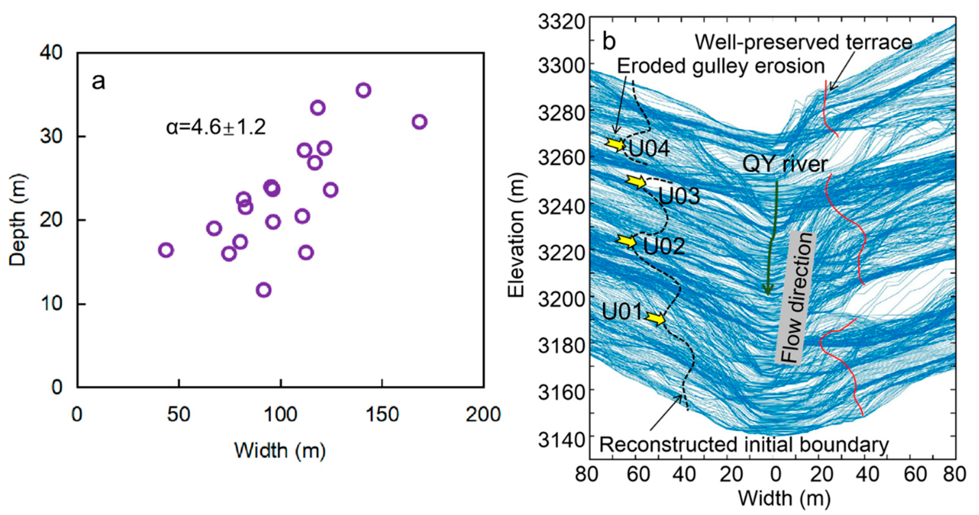
4.1. Initial Boundary of Fluvial Terrace
4.2. River Incision Rates
| Field Sample ID | Latitude North (deg) | Longitude East (deg) | Sample Depth (m) | Equivalent Dose (σ) Gy | Dose Rate (σ) Gy/ka | OSL Age (σ) ka | Height of Terrace (σ) m | Incision Rate (σ) mm/yr |
|---|---|---|---|---|---|---|---|---|
| OSL-01 | 38.169 | 100.438 | 2.3 | 126.81 (1.10) | 3.87 (0.10) | 32.79 (0.89) | 12.5 (0.1) | 0.38 (0.01) |
| OSL-02 | 38.169 | 100.437 | 1.4 | 162.44 (1.79) | 3.63 (0.09) | 44.70 (1.25) | 13.0 (0.1) | 0.29 (0.01) |
| OSL-03 | 38.169 | 100.437 | 1.0 | 396.35 (19.67) | 4.41 (0.26) | 89.92 (6.9) | 18.5 (0.1) | 0.21 (0.02) |
| OSL-04 | 38.175 | 100.431 | 2.2 | 351.01 (7.91) | 3.74 (0.10) | 93.83 (3.34) | 29.5 (0.1) | 0.31 (0.01) |
| OSL-05 | 38.175 | 100.431 | 2.3 | 401.67 (11.11) | 3.43 (0.10) | 117.04 (4.63) | 29.0 (0.1) | 0.25 (0.01) |
| OSL-06 | 38.176 | 100.430 | 1.5 | 324.1 (11.18) | 4.42 (0.22) | 73.33 (4.41) | 28.0 0.1) | 0.38 (0.02) |
| OSL-07 | 38.176 | 100.430 | 1.1 | 388.97 (3.25) | 4.81 (0.26) | 80.90 (5.20) | 27.5 0.1) | 0.34 (0.02) |
| OSL-08 | 38.176 | 100.430 | 1.6 | 240.01 (3.33) | 3.31 (0.09) | 72.58 (2.16) | 28.0 (0.1) | 0.39 (0.01) |
4.3. Hillslope Erosion Rates
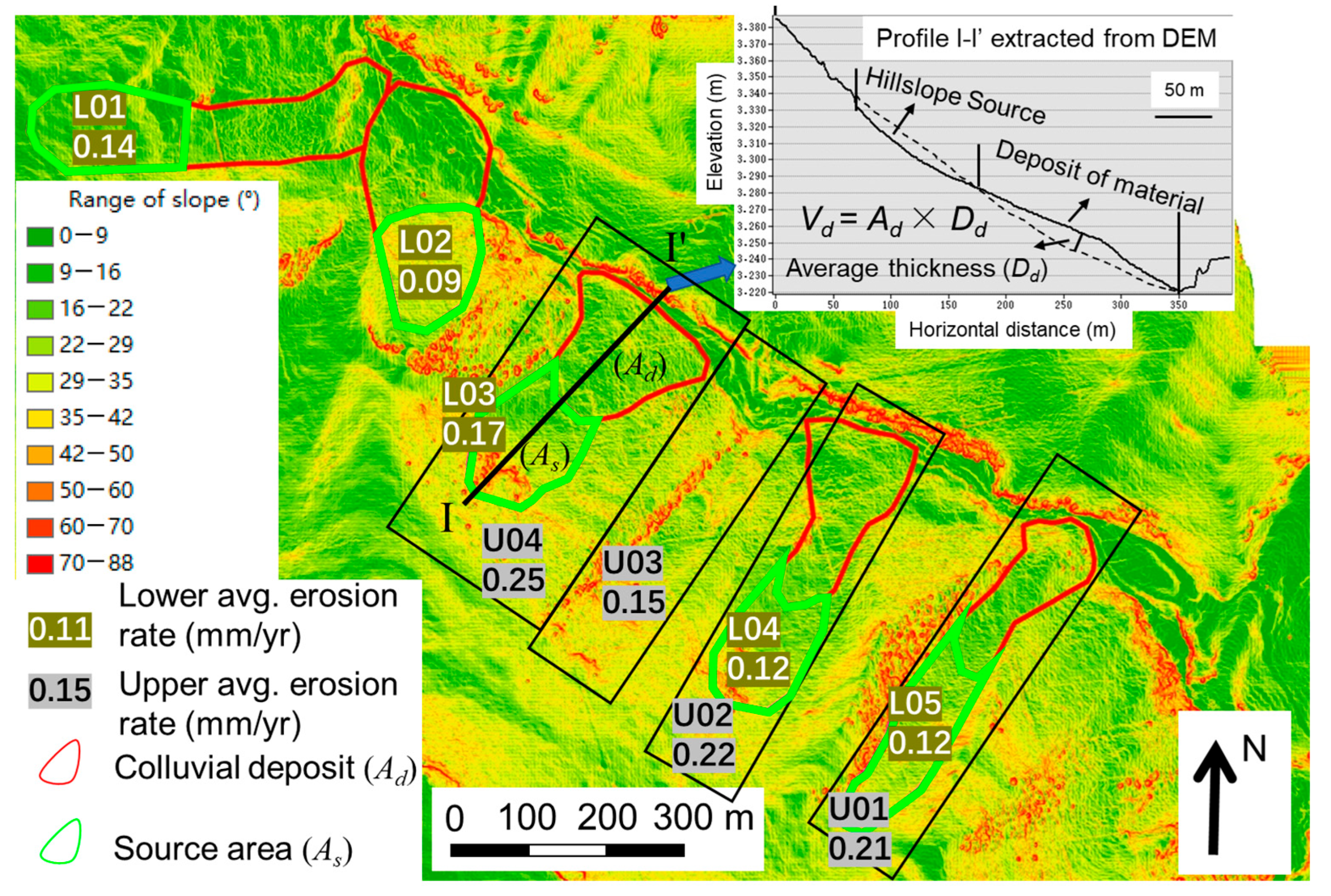
| No. | Ad (m2) | Dd (m) | Vd (m3) | As (m2) | Erosion Depth (m) | Min. of Eh-l (mm/yr) | Max. of Eh-l (mm/yr) |
|---|---|---|---|---|---|---|---|
| L01 | 20,679 | 11.4 | 235,743 | 18,225 | 12.9 | 0.11 | 0.18 |
| L02 | 21,608 | 5.5 | 118,848 | 15,448 | 7.7 | 0.07 | 0.11 |
| L03 | 22,414 | 11.6 | 260,004 | 17,582 | 14.8 | 0.13 | 0.20 |
| L04 | 21,426 | 7.3 | 156,413 | 15,417 | 10.2 | 0.09 | 0.14 |
| L05 | 15,106 | 12.8 | 193,359 | 17,627 | 11.0 | 0.09 | 0.15 |
| No. | Ave, Depth Reduction (da) (m) | Max. Eh-u (mm/yr) | Min. Eh-u (mm/yr) |
|---|---|---|---|
| U01 | 19.2 | 0.26 | 0.16 |
| U02 | 20.0 | 0.28 | 0.17 |
| U03 | 13.9 | 0.19 | 0.12 |
| U04 | 22.8 | 0.31 | 0.19 |
5. Discussion
6. Conclusions
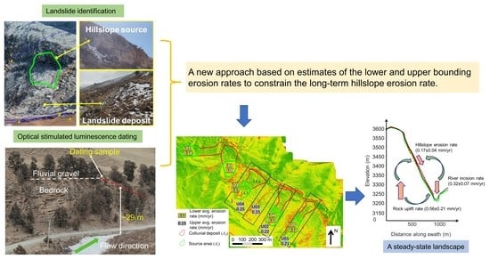
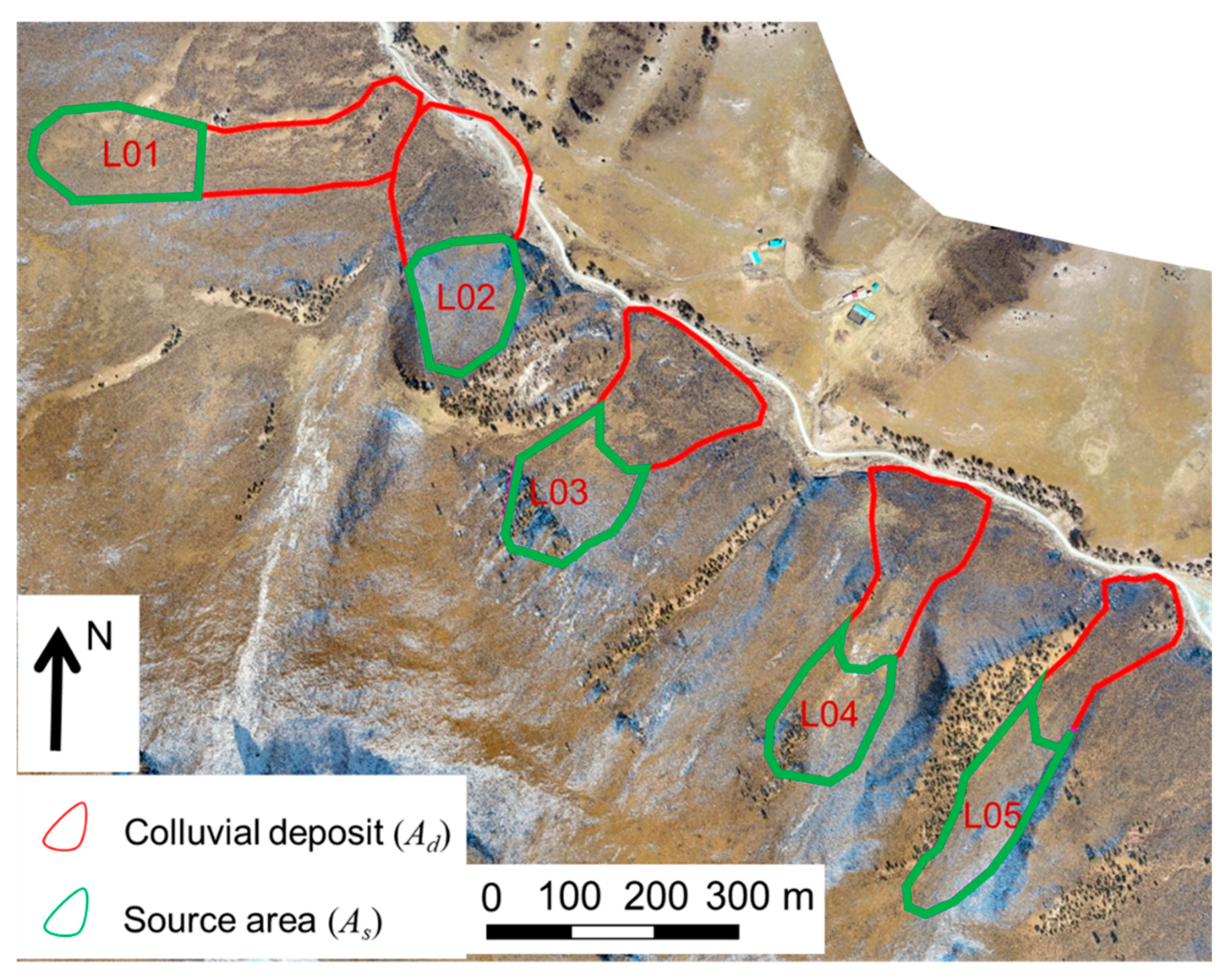
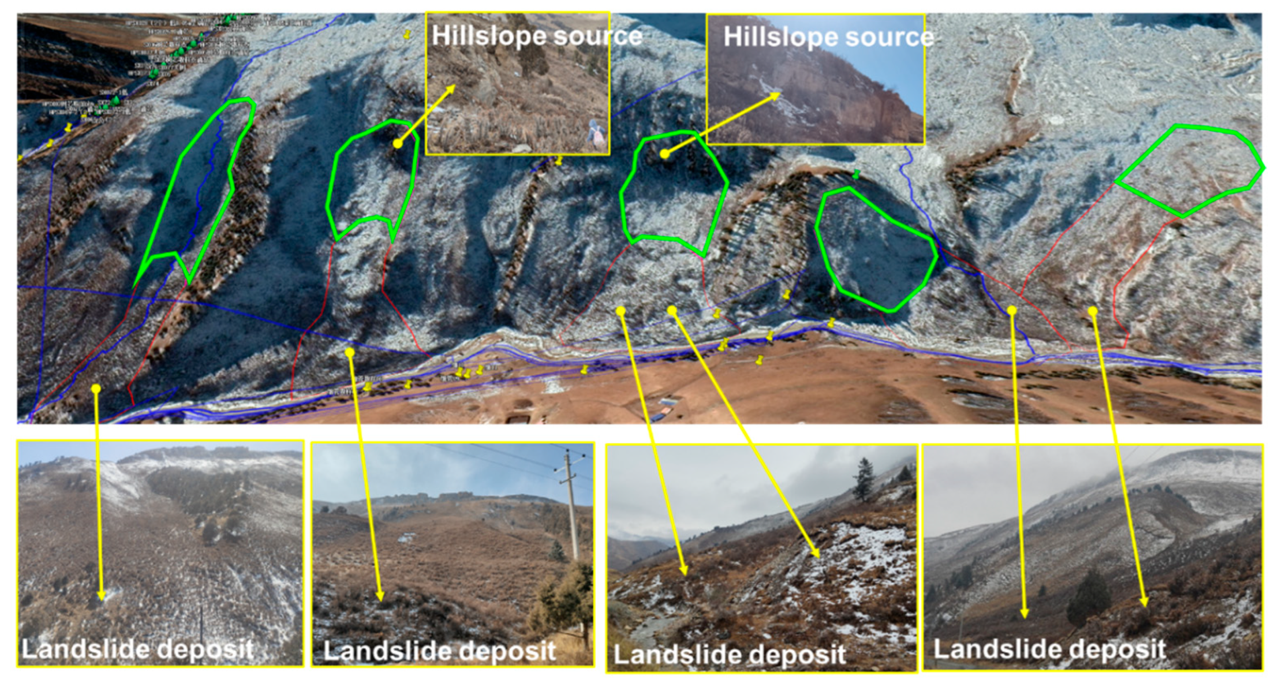
- Using remote sensing, topographic analysis, and field investigation, we identified five convex colluvial landforms at the base of weathered hillslopes at Qingyang Mountain with a total thickness of 5.5–12.8 m and volumes ranging from 119 × 103 to 260 × 103 m3. The colluvial sediments accumulated after a bedrock strath 27.5–29.5 m above the present river level was abandoned, i.e., sometime after 73.33 ± 4.41 to 117.04 ± 4.63 kyr ago.
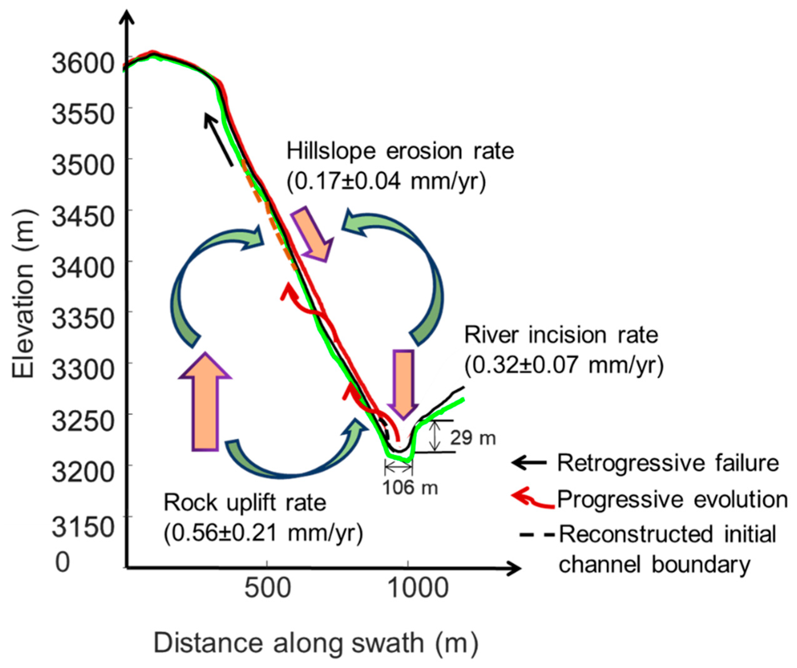
- We proposed an approach based on estimates of the lower and upper bounding erosion rates to constrain the long-term hillslope erosion rate at Qingyang Mountain. Applying this approach, we estimated the average hillslope erosion rate in this part of the eastern QYM to be between 0.13 ± 0.03 and 0.21 ± 0.04 mm/yr (average of 0.17 ± 0.04 mm/yr).
- Considering the published regional uplift rates (0.18–1.90 mm/yr) and the calculated rates of river incision (0.32 ± 0.07 mm/yr) and hillslope erosion (0.17 ± 0.04 mm/yr) in QYM, we hypothesize that QYM has been in a steady state over at least the past 100 ka.
Author Contributions
Funding
Data Availability Statement
Acknowledgments
Conflicts of Interest
References
- Herman, F.; Seward, D.; Valla, P.G.; Carter, A.; Kohn, B.; Willett, S.D.; Ehlers, T.A. Worldwide acceleration of mountain erosion under a cooling climate. Nature 2013, 504, 423–426. [Google Scholar] [CrossRef] [PubMed]
- Val, P.; Venerdini, A.L.; Ouimet, W.; Alvarado, P.; Hoke, G.D. Tectonic control of erosion in the southern Central Andes. Earth Planet. Sci. Lett. 2018, 482, 160–170. [Google Scholar] [CrossRef]
- Zhang, J.; Liu-Zeng, J.; Scherler, D.; Yin, A.; Wang, W.; Tang, M.-Y.; Li, Z.-F. Spatiotemporal variation of late Quaternary river incision rates in southeast Tibet, constrained by dating fluvial terraces. Lithosphere 2018, 10, 662–675. [Google Scholar] [CrossRef]
- Adams, B.A.; Whipple, K.X.; Forte, A.M.; Heimsath, A.M.; Hodges, K.V. Climate controls on erosion in tectonically active landscapes. Sci. Adv. 2020, 6, eaaz3166. [Google Scholar] [CrossRef]
- Lan, H.; Peng, J.; Zhu, Y.; Li, L.; Pan, B.; Huang, Q.; Li, J.; Zhang, Q. Geological and surficial processes and major disaster effects in the Yellow River Basin. Sci. China Earth Sci. 2022, 65, 234–256. [Google Scholar] [CrossRef]
- Zhang, W.; Wang, J.; Chen, J.; Soltanian, M.R.; Dai, Z.; WoldeGabriel, G. Mass-wasting-inferred dramatic variability of 130,000-year Indian summer monsoon intensity from deposits in the southeast Tibetan Plateau. Geophys. Res. Lett. 2022, 49, e2021GL097301. [Google Scholar] [CrossRef]
- Burbank, D.W.; Leland, J.; Fielding, E.; Anderson, R.S.; Liu, N.; Reid, M.R.; Duncan, C. Bedrock incision, rock uplift and threshold hillslopes in the northwestern Himalayas. Nature 1996, 379, 505–510. [Google Scholar] [CrossRef]
- Montgomery, D.R.; Brandon, M.T. Topographic controls on erosion rates in tectonically active mountain ranges. Earth Planet. Sci. Lett. 2002, 201, 481–489. [Google Scholar] [CrossRef]
- Larsen, I.J.; Montgomery, D.R. Landslide erosion coupled to tectonics and river incision. Nat. Geosci. 2012, 5, 468–473. [Google Scholar] [CrossRef]
- Burbank, D.W. Rates of erosion and their implications for exhumation. Mineral. Mag. 2002, 66, 25–52. [Google Scholar] [CrossRef]
- Korup, O. Rock type leaves topographic signature in landslide-dominated mountain ranges. Geophys. Res. Lett. 2008, 35, L11402. [Google Scholar] [CrossRef]
- Ouimet, W.B.; Whipple, K.X.; Granger, D.E. Beyond threshold hillslopes: Channel adjustment to base-level fall in tectonically active mountain ranges. Geology 2009, 37, 579–582. [Google Scholar] [CrossRef]
- DiBiase, R.A.; Heimsath, A.M.; Whipple, K.X. Hillslope response to tectonic forcing in threshold landscapes. Earth Surf. Process. Landf. 2012, 37, 855–865. [Google Scholar] [CrossRef]
- Montgomery, D.R. Slope distributions, threshold hillslopes, and steady-state topography. Am. J. Sci. 2001, 301, 432–454. [Google Scholar] [CrossRef]
- Cyr, A.J.; Granger, D.E. Dynamic equilibrium among erosion, river incision, and coastal uplift in the northern and central Apennines, Italy. Geology 2008, 36, 103–106. [Google Scholar] [CrossRef]
- Zondervan, J.R.; Stokes, M.; Boulton, S.J.; Telfer, M.W.; Mather, A.E. Rock strength and structural controls on fluvial erodibility: Implications for drainage divide mobility in a collisional mountain belt. Earth Planet. Sci. Lett. 2020, 538, 116221. [Google Scholar] [CrossRef]
- Malatesta, L.C.; Avouac, J.P.; Brown, N.D.; Breitenbach, S.F.M.; Pan, J.W.; Chevalier, M.L.; Rhode, E.; Saint-Carlier, D.; Zhang, W.J.; Charreau, J.L.; et al. Lag and mixing during sediment transfer across the Tian Shan piedmont caused by climate-driven aggradation-incision cycles. Basin Res. 2018, 30, 613–635. [Google Scholar] [CrossRef]
- Liu, P.; Wei, Y.; Wang, Q.; Chen, Y.; Xie, J. Research on post-earthquake landslide extraction algorithm based on improved U-Net Model. Remote Sens. 2020, 12, 894. [Google Scholar] [CrossRef]
- Karagianni, A.; Lazos, I.; Chatzipetros, A. Remote sensing techniques in disaster management: Amynteon Mine landslides, Greece. In Intelligent Systems for Crisis Management; Lecture Notes in Geoinformation and Cartography; Springer International Publishing: Cham, Switzerland, 2019; pp. 209–235. [Google Scholar] [CrossRef]
- Kalantar, B.; Ueda, N.; Saeidi, V.; Ahmadi, K.; Halin, A.A.; Shabani, F. Landslide susceptibility mapping: Machine and ensemble learning based on remote sensing big data. Remote Sens. 2020, 12, 1737. [Google Scholar] [CrossRef]
- Pan, B.T.; Hu, X.F.; Gao, H.S.; Hu, Z.B.; Cao, B.; Geng, H.P.; Li, Q.Y. Late Quaternary river incision rates and rock uplift pattern of the eastern Qilian Shan Mountain, China. Geomorphology 2013, 184, 84–97. [Google Scholar] [CrossRef]
- Tapponnier, P.; Meyer, B.; Avouac, J.P.; Peltzer, G.; Gaudemer, Y.; Guo, S.M.; Xiang, H.F.; Yin, K.L.; Chen, Z.T.; Cai, S.H.; et al. Active thrusting and folding in the Qilian Shan, and decoupling between upper crust and mantle in northeastern Tibet. Earth Planet. Sci. Lett. 1990, 97, 382–403. [Google Scholar] [CrossRef]
- Hetzel, R.; Niedermann, S.; Tao, M.; Kubik, P.W.; Ivy-Ochs, S.; Gao, B.; Strecker, M.R. Low slip rates and long-term preservation of geomorphic features in Central Asia. Nature 2002, 417, 428–432. [Google Scholar] [CrossRef] [PubMed]
- Zhang, P.; Shen, Z.; Burgman, R.; Molnar, P.; Wang, Q.; Niu, Z.; Sun, J.; Wu, J.; Sun, H.; You, X. Continuous deformation of the Tibetan Plateau constrained from global positioning measurements. Geology 2004, 32, 809–812. [Google Scholar] [CrossRef]
- Yuan, D.; Zhang, P.; Liu, B.; Gan, W.; Mao, F.; Wang, Z.; Zheng, D.; Guo, H. Geometrical imagery and tectonic transformation of late Quaternary active tectonics in northeastern margin of Qinghai-Xizang Plateau. Acta Geol. Sin. 2004, 78, 270–278. [Google Scholar]
- Li, C.Y.; Zhang, P.Z.; Yin, J.H.; Min, W. Late Quaternary left-lateral slip rate of the Haiyuan fault, northeastern margin of the Tibetan Plateau. Tectonics 2009, 28, TC5010. [Google Scholar] [CrossRef]
- Ji, T.; Zheng, W.; Yang, J.; Zhang, D.; Liang, S.; Li, Y.; Liu, T.; Zhou, H.; Feng, C. Tectonic significances of the geomorphic evolution in the southern Alashan Block to the outward expansion of the northeastern Tibetan Plateau. Remote Sens. 2022, 14, 6269. [Google Scholar] [CrossRef]
- Hetzel, R.; Tao, M.-X.; Niedermann, S.; Strecker, M.R.; Ivy-Ochs, S.; Kubik, P.W.; Gao, B. Implications of the fault scaling law for the growth of topography: Mountain ranges in the broken foreland of NE Tibet. Terra Nova 2004, 16, 157–162. [Google Scholar] [CrossRef]
- Chen, W.B. Principal Features of Tectonic Deformation and Their Generation Mechanism in the Hexi Corridor and Its Adjacent Regions Since Late Quaternary; Institute of Geology, China Seismological Bureau: Beijing, China, 2003; pp. 32–55. (In Chinese) [Google Scholar]
- Zheng, W.J.; Zhang, P.Z.; Ge, W.P.; Molnar, P.; Zhang, H.P.; Yuan, D.Y.; Liu, J.H. Late Quaternary slip rate of the South Heli Shan Fault (northern Hexi Corridor, NW China) and its implications for northeastward growth of the Tibetan Plateau. Tectonics 2013, 32, 271–293. [Google Scholar] [CrossRef]
- Zhang, Y.; Stoffel, M.; Liang, E.Y.; Guillet, S.; Shao, X.M. Centennial-scale process activity in a complex landslide body in the Qilian Mountains, northeast Tibetan Plateau, China. Catena 2019, 179, 29–38. [Google Scholar] [CrossRef]
- ISRM. Suggested methods for the quantitative description of discontinuities in rock masses. Int. J. Rock Mech. Min. Sci. Geomech. Abstr. 1978, 15, 319–368. [Google Scholar] [CrossRef]
- Johnson, K.; Nissen, E.; Saripalli, S.; Arrowsmith, J.R.; McGarey, P.; Scharer, K.; Williams, P.; Blisniuk, K. Rapid mapping of ultrafine fault zone topography with structure from motion. Geosphere 2014, 10, 969–986. [Google Scholar] [CrossRef]
- Wang, X.L.; Crosta, G.B.; Clague, J.J.; Stead, D.; Sun, J.; Qi, S.; Liu, H. Fault controls on spatial variation of fracture density and rock mass strength within the Yarlung Tsangpo Fault damage zone (southeastern Tibet). Eng. Geol. 2021, 291, 106238. [Google Scholar] [CrossRef]
- Wegmann, K.W.; Pazzaglia, F.J. Late Quaternary fluvial terraces of the Romagna and Marche Apennines, Italy: Climatic, lithologic, and tectonic controls on terrace genesis in an active orogeny. Quat. Sci. Rev. 2009, 28, 37–165. [Google Scholar] [CrossRef]
- Malamud, B.D.; Turcotte, D.L.; Guzzetti, F.; Reichenbach, P. Landslides, earthquakes, and erosion. Earth Planet. Sci. Lett. 2004, 229, 45–59. [Google Scholar] [CrossRef]
- Pan, B.T.; Gao, H.S.; Wu, G.J.; Li, J.J.; Li, B.Y.; Ye, Y.G. Dating of erosion surface and terraces in the eastern Qilian Shan, northwest China. Earth Surf. Process. Landf. 2007, 32, 143–154. [Google Scholar] [CrossRef]



Disclaimer/Publisher’s Note: The statements, opinions and data contained in all publications are solely those of the individual author(s) and contributor(s) and not of MDPI and/or the editor(s). MDPI and/or the editor(s) disclaim responsibility for any injury to people or property resulting from any ideas, methods, instructions or products referred to in the content. |
© 2023 by the authors. Licensee MDPI, Basel, Switzerland. This article is an open access article distributed under the terms and conditions of the Creative Commons Attribution (CC BY) license (https://creativecommons.org/licenses/by/4.0/).
Share and Cite
Wang, X.; Zhang, Y.; Clague, J.J.; Guo, S.; Jiao, Q.; Wang, J.; Sun, J.; Fang, W.; Qi, S. Study of a Steady-State Landscape Using Remote Sensing and Topographic Analysis. Remote Sens. 2023, 15, 2583. https://doi.org/10.3390/rs15102583
Wang X, Zhang Y, Clague JJ, Guo S, Jiao Q, Wang J, Sun J, Fang W, Qi S. Study of a Steady-State Landscape Using Remote Sensing and Topographic Analysis. Remote Sensing. 2023; 15(10):2583. https://doi.org/10.3390/rs15102583
Chicago/Turabian StyleWang, Xueliang, Yanjie Zhang, John J. Clague, Songfeng Guo, Qisong Jiao, Junfei Wang, Juanjuan Sun, Wenxin Fang, and Shengwen Qi. 2023. "Study of a Steady-State Landscape Using Remote Sensing and Topographic Analysis" Remote Sensing 15, no. 10: 2583. https://doi.org/10.3390/rs15102583
APA StyleWang, X., Zhang, Y., Clague, J. J., Guo, S., Jiao, Q., Wang, J., Sun, J., Fang, W., & Qi, S. (2023). Study of a Steady-State Landscape Using Remote Sensing and Topographic Analysis. Remote Sensing, 15(10), 2583. https://doi.org/10.3390/rs15102583


