Using CORONA Imagery to Study Land Use and Land Cover Change—A Review of Applications
Abstract
:1. Introduction
2. Methods
- declassified corona data
- “corona image”
- corona spy satellite
- declassified spy satellite
- “corona images”
- “corona imagery”
- Spatial aspects
- 1.1.
- In which regions and countries CORONA images were used?
- 1.2.
- What was the size of the study area?
- 1.3.
- How did CORONA images cover the study area (entire study area–wall-to-wall mapping or a part of the study area using pre-defined sampling)?
- Thematic aspects
- 2.1.
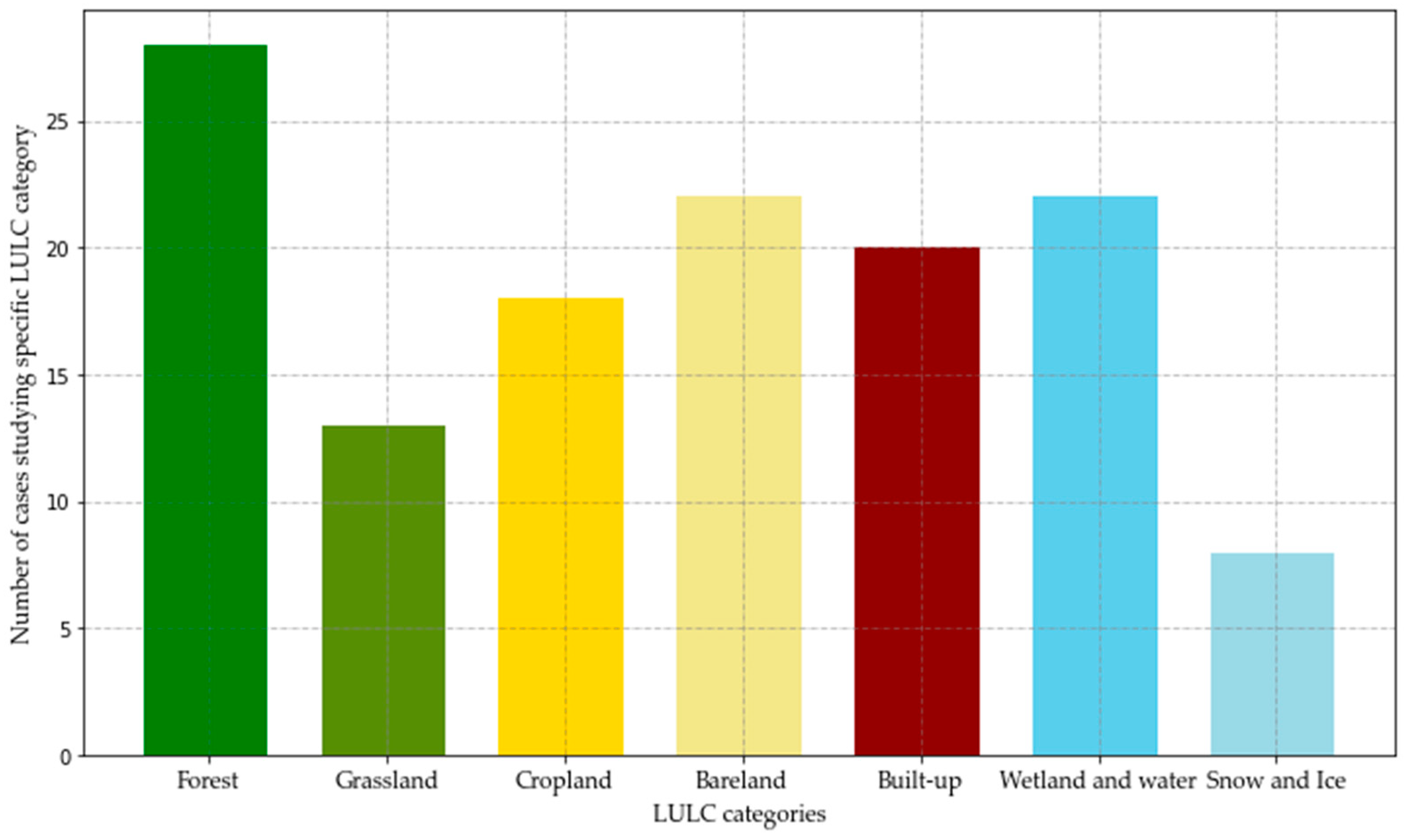
- What LULC categories were studied using CORONA images?
- 2.2.
- Which methods of LULC identification, interpretation and analysis were applied for CORONA images?
- Temporal aspects
- 3.1.
- Was the LULC analysis a single moment (related to the 1960s-1970s, using only CORONA images and other geospatial data for this time period) or was it multitemporal?
- 3.2.
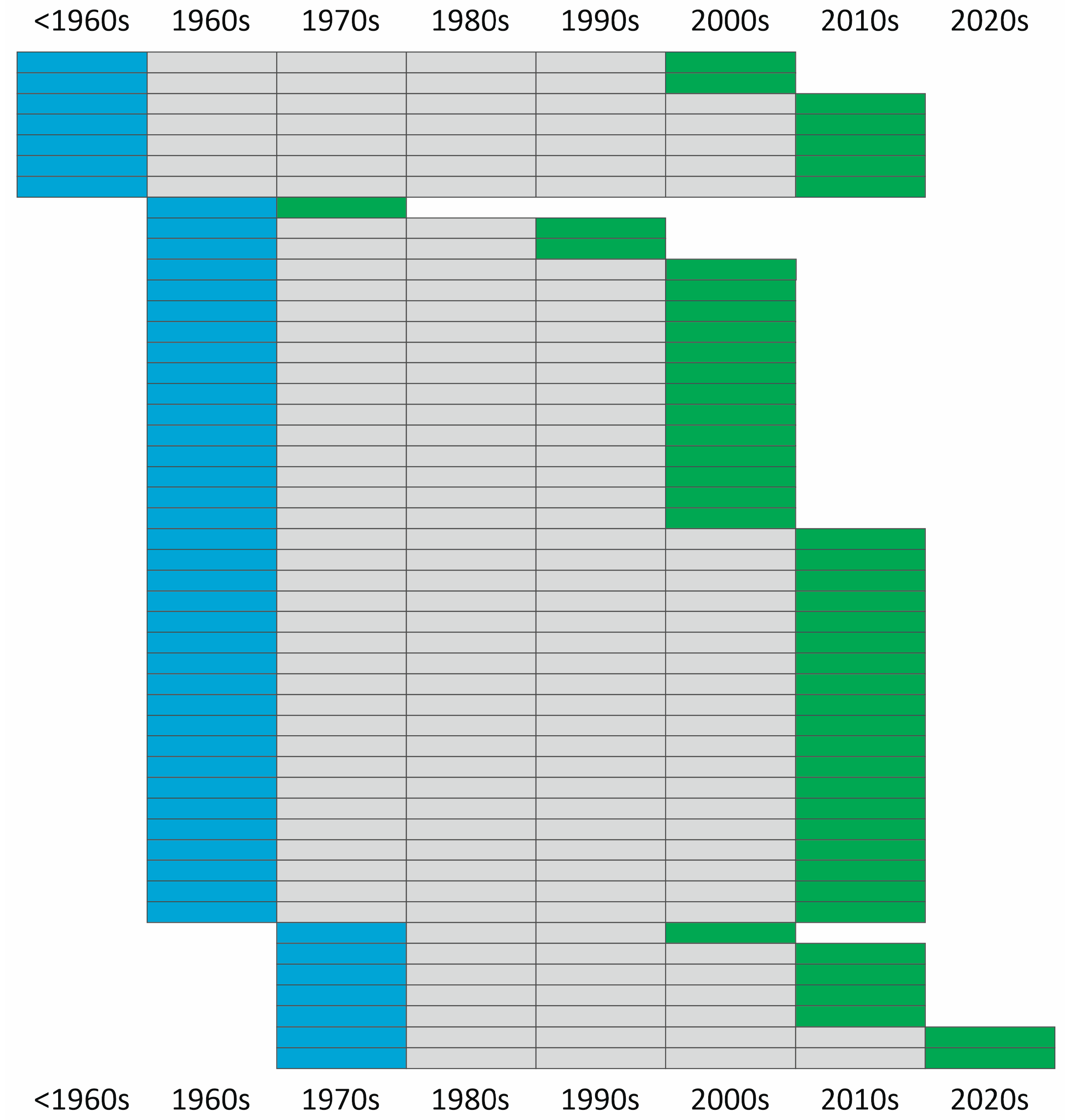
- If it is multitemporal, what time period was analyzed in the study?
- 3.3.
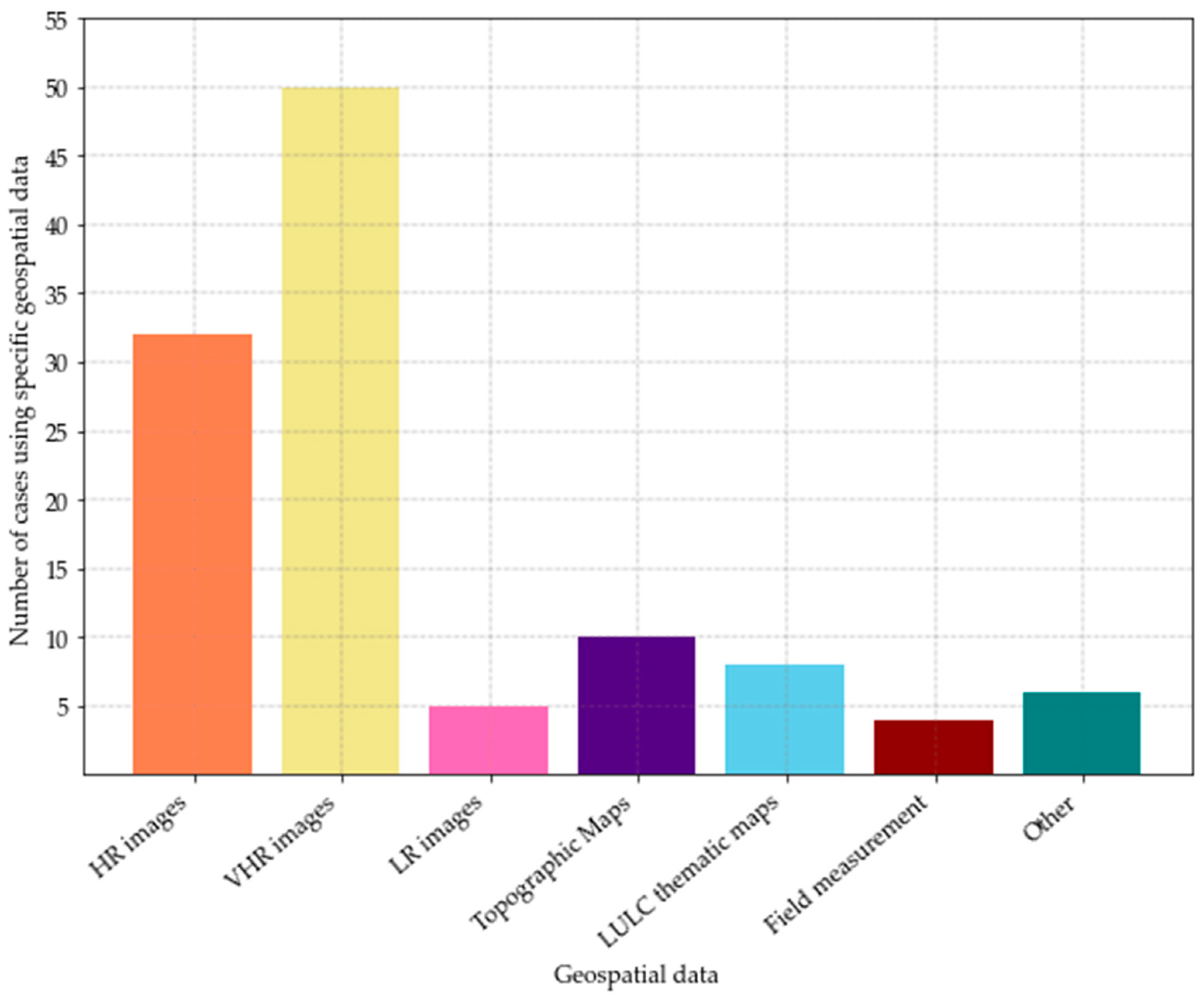
- If it is multitemporal, what geospatial data were analyzed alongside CORONA images?
3. Results
3.1. Database Query
3.2. LULC Studies with CORONA Imagery
3.2.1. Spatial Aspects
3.2.2. Thematic Aspects
3.2.3. Temporal Aspects
4. Discussion
5. Conclusions
Author Contributions
Funding
Data Availability Statement
Acknowledgments
Conflicts of Interest
Appendix A
| Papers | Country(ies) | Area sq km | Mapping Extent | Method | LC Classes | Temporal Aspect |
|---|---|---|---|---|---|---|
| [45] Agapiou, A., 2021. | Cyprus | 40 * | Wall to wall | Automated | Built-up, bare land and sparse vegetation, forest, wetland and water | Single moment |
| [29] Andersen, G.L., 2006. | Egypt | 10,000 * | Sampling | Manual | Bare land and sparse vegetation | Multi-temporal |
| [74] Andersen, G.L.; Krzywinski, K., 2007. | Egypt | 10,000 * | Sampling | Manual | Bare land and sparse vegetation | Multi-temporal |
| [81] Ardelean, F. et al., 2020. | Russia | 200 | Sampling | Manual | Wetland and water | Multi-temporal |
| [82] Bhambri, R. et al., 2012. | India | 4 * | Wall to wall | Manual | Snow and ice, bare land and sparse vegetation | Multi-temporal |
| [53] Bolch, T. et al., 2022. | Nepal | 2000 | Wall to wall | Manual | Snow and ice, wetland and water | Multi-temporal |
| [54] Brandt, M. et al., 2014. | Mali, Senegal | 5000 * | Sampling | Manual | Bare land and sparse vegetation, grassland, cropland, forest | Multi-temporal |
| [72] Brinkmann, K. et al., 2012. | Niger, Nigeria, Mali, Burkina Faso | 4200 * | Wall to wall | Both | Built-up, cropland, grassland, wetland and water, forest, bare land and sparse vegetation | Multi-temporal |
| [71] Chen, Y.-C. et al., 2020. | Taiwan | 900 | Wall to wall | Automated | Wetland and water, cropland, built-up | Multi-temporal |
| [37] Chmielewski, S. et al., 2020. | Poland | 2 * | Wall to wall | Both | Built-up, forest, grassland, wetland and water, cropland, bare land and sparse vegetation | Multi-temporal |
| [83] Conesa et al., 2014. | India | 20,000 * | Sampling | Manual | Built-up | Multi-temporal |
| [44] Deshpande, P. et al., 2021. | India | 43 * | Sampling | Automated | Bare land and sparse vegetation, cropland, wetland and water, built-up | Single moment |
| [76] DeWitt, J.D. et al., 2017. | Côte d’Ivoire | 90 * | Sampling | Manual | Bare land and sparse vegetation | Multi-temporal |
| [8] Dittrich, A. et al., 2010. | China | 482 | Wall to wall | Manual | Built-up, cropland, grassland, wetland and water | Multi-temporal |
| [5] Fekete, A., 2020. | Peru | 6 * | Wall to wall | Manual | Built-up | Multi-temporal |
| [69] Franklin, S.E. et al., 2005. | Canada | 717.9 | Wall to wall | Manual | bare land and sparse vegetation, wetland and water, forest, grassland, snow and ice | Multi-temporal |
| [84] Ganyushkin, D.A. et al., 2018. | Russia, Mongolia, China | 2600 | Wall to wall | Manual | Snow and ice | Multi-temporal |
| [66] Gurjar, S.K.; Tare, V., 2019. | India | 22,400 | Wall to wall | Both | Wetland and water, cropland, grassland, bare land and sparse vegetation, forest, built-up | Multi-temporal |
| [85] Hamandawana, H. et al., 2005. | Botswana | 60,000 * | Wall to wall | Manual | Wetland and water | Multi-temporal |
| [86] Herrmann, S. M. et al., 2013. | Senegal | 26,000 | Sampling | Manual | Forest | Multi-temporal |
| [46] Htwe, T. et al., 2015 | Myanmar | 2115 | Wall to wall | Manual | Forest, bare land and sparse vegetation, cropland, built-up, wetland and water, grassland | Multi-temporal |
| [26] Jabs-Sobocińska, Z. et al., 2021. | Poland | 2212.44 | Wall to wall | Automated | Forest, cropland | Multi-temporal |
| [87] Jelil Niang, A. et al., 2020. | Saudi Arabia | 10 * | Wall to wall | Manual | Built-up | Multi-temporal |
| [58] Klimetzek, D et al., 2021. | Romania | 20.40 | Wall to wall | Manual | Forest | Multi-temporal |
| [40] Lasaponara, R., et al., 2017. | Egypt, Iran | Egypt: 42 * Iran: 8 * | Wall to wall | Automated | Built-up, cropland, wetland and water, bare land and sparse vegetation | Multi-temporal |
| [65] Leempoel, K. et al., 2013. | China | 200 | Wall to wall | Manual | Wetland and water, cropland, forest | Multi-temporal |
| [88] Lele, N. et al., 2015. | India | 5.4 | Wall to wall | Manual | Grassland | Multi-temporal |
| [89] Łuców, D. et al., 2020. | Russia | 5.44 | Wall to wall | Both | Wetland and water, built-up, forest, cropland | Multi-temporal |
| [90] Mal, S. et al., 2019. | India | 250 * | Sampling | Manual | Snow and ice, bare land and sparse vegetation | Multi-temporal |
| [67] Marzolff, I. et al., 2022. | Morocco | 10,000 * | Sampling | Manual | Forest | Multi-temporal |
| [91] Mergili, M.P. et al., 2013. | Tajikistan, Kyrgyzstan, Afghanistan | 98,300 | Wall to wall | Manual | Wetland and water | Multi-temporal |
| [64] Mészáros, M. et al., 2014. | Serbia | 230 | Wall to wall | Manual | Forest | Multi-temporal |
| [73] Munteanu, C. et al., 2020. | Kazakhstan | 60,000 | Sampling | Both | Grassland, cropland, | Multi-temporal |
| [57] Nistor, C. et al., 2021. | Romania | 228 | Wall to wall | Manual | Built-up, bare land and sparse vegetation, forest, wetland and water, grassland, cropland | Multi-temporal |
| [42] Nita, M. D. et al., 2018. | Romania | 212,000 | Wall to wall | Manual | Forest | Single moment |
| [70] Pan, X. et al., 2021. | China | 231 * | Wall to wall | Automated | Built-up | Multi-temporal |
| [47] Racoviteanu, A.E. et al., 2022. | Nepal | 1971 | Wall to wall | Manual | Snow and ice, wetland and water | Multi-temporal |
| [39] Rannow, S., 2013. | Norway | 8000 | Wall-to-wall and sampling | Manual | Forest | Multi-temporal |
| [52] Rendenieks, Z. et al., 2020. | Russia, Latvia | 22,209 | Sampling | Automated | Forest | Multi-temporal |
| [62] Rigina, O., 2003. | Russia | 2880 | Wall to wall | Automated | Forest, bare land and sparse vegetation, built-up, wetland and water | Multi-temporal |
| [41] Saleem, A. et al., 2018. | Iraq | 44,957.1 | Wall to wall | Automated | Wetland and water, built-up, forest, bare land and sparse vegetation, cropland | Multi-temporal |
| [43] Saleem, A. et al., 2021. | Iraq, Iran, Syria | 2896.3 | Sampling | Both | Built-up, cropland, forest, bare land and sparse vegetation | Single moment |
| [28] Shahbandeh, M. et al., 2022. | Poland | 451.81 | Wall to wall | Manual | Forest, cropland, grassland | Multi-temporal |
| [55] Shalaby, H. et al., 2022. | Egypt | 300 | Wall to wall | Manual | Built-up | Multi-temporal |
| [63] She, J. et al., 2014. | China | 5518 | Sampling | Manual | Snow and ice | Multi-temporal |
| [6] Song, D.-X. et al., 2015. | USA, Brazil | 2000 | Sampling | Automated | Forest | Multi-temporal |
| [30] Song, D.-X. et al., 2021. | China | 484,000 | Sampling | Automated | Forest | Multi-temporal |
| [77] Spiekermann, R. et al., 2015. | Mali | 3600 | Wall to wall | Automated | Forest, bare land and sparse vegetation | Multi-temporal |
| [56] Stăncioiu, P.T. et al., 2021. | Romania | 80,000 * | Sampling | Manual | Forest | Multi-temporal |
| [92] Stokes, C.R. et al., 2006. | Russia, Georgia | 3000 * | Sampling | Manual | Snow and ice | Multi-temporal |
| [61] Stratoulias & Grekousis, 2021. | Bulgaria | 1600 * | Wall to wall | Automated | Built-up | Single moment |
| [93] Tappan, G. Gray, et al., 2000 | Senegal | 2133.55 | Wall to wall | Manual | Bare land and sparse vegetation, wetland and water, forest, grassland, cropland | Multi-temporal |
| [38] Victorov, A. et al., 2022. | Russia, USA, Canada | >1 mln * | Sampling | Manual | Wetland and water, bare land and sparse vegetation | Multi-temporal |
| [21] Zhang, Y. et al., 2020. | China | 6 * | Wall to wall | Manual | Forest | Multi-temporal |
References
- Burnett, M.G. (Ed.) Hexagon (KH-9) Mapping Camera Program and Evolution; Center for the Study of National Reconnaissance: Chantilly, VA, USA, 2012. [Google Scholar]
- Wheelon, A.D. Corona: The First Reconnaissance Satellites. Phys. Today 1997, 50, 24–30. [Google Scholar] [CrossRef]
- Mihai, B.; Nistor, C.; Toma, L.; Săvulescu, I. High Resolution Landscape Change Analysis with CORONA KH-4B Imagery. A Case Study from Iron Gates Reservoir Area. Procedia Environ. Sci. 2016, 32, 200–210. [Google Scholar] [CrossRef]
- Ur, J.A. CORONA Satellite Imagery and Ancient Near Eastern Landscapes. In Mapping Archaeological Landscapes from Space; Springer Briefs in Archaeology; Springer: New York, NY, USA, 2013; pp. 21–31. [Google Scholar] [CrossRef]
- Fekete, A. CORONA High-Resolution Satellite and Aerial Imagery for Change Detection Assessment of Natural Hazard Risk and Urban Growth in El Alto/La Paz in Bolivia, Santiago de Chile, Yungay in Peru, Qazvin in Iran, and Mount St. Helens in the USA. Remote Sens. 2020, 12, 3246. [Google Scholar] [CrossRef]
- Song, D.X.; Huang, C.; Sexton, J.O.; Channan, S.; Feng, M.; Townshend, J.R. Use of Landsat and Corona data for mapping forest cover change from the mid-1960s to 2000s: Case studies from the Eastern United States and Central Brazil. ISPRS J. Photogramm. Remote Sens. 2015, 103, 81–92. [Google Scholar] [CrossRef]
- Yenne, B. The Encyclopedia of U.S. Spacecraft; Exeter Books (A Bison Book); Simon & Schuster Books: New York, NY, USA, 1985; ISBN 978-0-671-07580-4. [Google Scholar]
- Dittrich, A.; Buerkert, A.; Brinkmann, K. Assessment of land use and land cover changes during the last 50 years in oases and surrounding rangelands of Xinjiang, NW China. J. Agric. Rural Dev. Trop. Subtrop. 2010, 111, 129–142. [Google Scholar]
- Corona Program. Available online: http://space.jpl.nasa.gov/msl/Programs/corona.html (accessed on 13 May 2023).
- Manaugh, G. Zooming-In on Satellite Calibration Targets in the Arizona Desert. Atlas Obscura 2014. Available online: https://www.atlasobscura.com/places/corona-satellite-calibration-targets (accessed on 10 September 2022).
- The_CORONA_Program. Available online: https://www.nro.gov/History-and-Studies/Center-for-the-Study-of-National-Reconnaissance/The-CORONA-Program/ (accessed on 27 June 2022).
- Corona: America’s First Satellite Program; Center for the Study of Intelligence, Central Intelligence Agency: Langley, VA, USA, 1995; Available online: https://books.google.pl/books?hl=en&lr=&id=7AlgLBVWPV0C&oi=fnd&pg=PR11&dq=CORONA+imagery+satellites&ots=CmowzdDFcm&sig=zEAgEqBjDMi0lifsPnooKFIGMpo&redir_esc=y#v=onepage&q=CORONA%imagery%satellites&f=false (accessed on 20 September 2022).
- Declassified Intelligence Satellite Photographs Fact Sheet 090-96; United States Geological Survey: Reston, VA, USA, 1998.
- The CORONA Story; Center for the Study of National Reconnaissance Classics; Center for the Study of National Reconnaissance: Chantilly, VA, USA, 2013.
- Gheyle, W.; Bourgeois, J.; Goossens, R.; Jacobsen, K. Scan problems in digital CORONA satellite images from USGS archives. Photogramm. Eng. Remote Sens. 2011, 77, 1257–1264. [Google Scholar] [CrossRef]
- Dashora, A.; Lohani, B.; Malik, J.N. A repository of earth resource information—CORONA satellite programme. Curr. Sci. 2007, 92, 926–932. [Google Scholar]
- Dehecq, A.; Gardner, A.S.; Alexandrov, O.; McMichael, S.; Hugonnet, R.; Shean, D.; Marty, M. Automated Processing of Declassified KH-9 Hexagon Satellite Images for Global Elevation Change Analysis Since the 1970s. Front. Earth Sci. 2020, 8, 566802. [Google Scholar] [CrossRef]
- EarthExplorer. Available online: https://earthexplorer.usgs.gov/ (accessed on 7 November 2022).
- Challis, K.; Priestnall, G.; Gardner, A.; Henderson, J.; O’hara, S. Corona remotely-sensed imagery in dryland archaeology: The Islamic city of al-Raqqa, Syria. J. Field Archaeol. 2004, 29, 139–153. [Google Scholar] [CrossRef]
- Casana, J.; Cothren, J. The CORONA Atlas Project: Orthorectification of CORONA Satellite Imagery and Regional-Scale Archaeological Exploration in the Near East. In Mapping Archaeological Landscapes from Space; Springer Briefs in Archaeology; Springer: New York, NY, USA, 2013; pp. 33–43. [Google Scholar] [CrossRef]
- Zhang, Y.; Shen, W.; Li, M.; Lv, Y. Integrating Landsat Time Series Observations and Corona Images to Characterize Forest Change Patterns in a Mining Region of Nanjing, Eastern China from 1967 to 2019. Remote Sens. 2020, 12, 3191. [Google Scholar] [CrossRef]
- Iacone, B.; Allington, G.R.H.; Engstrom, R. A Methodology for Georeferencing and Mosaicking Corona Imagery in Semi-Arid Environments. Remote Sens. 2022, 14, 5395. [Google Scholar] [CrossRef]
- Awange, J.; Kiema, J. CORONA Historical De-classified Products. In Environmental Geoinformatics; Environmental Science and Engineering Series (ENVSCIENCE); Springer: Cham, Switzerland, 2019; pp. 191–199. [Google Scholar] [CrossRef]
- Rizayeva, A.; Nita, M.D.; Radeloff, V.C. Large-area, 1964 land cover classifications of Corona spy satellite imagery for the Caucasus Mountains. Remote Sens. Environ. 2023, 284, 113343. [Google Scholar] [CrossRef]
- Olariu, B.; Vîrghileanu, M.; Mihai, B.A.; Săvulescu, I.; Toma, L.; Săvulescu, M.G. Forest Habitat Fragmentation in Mountain Protected Areas Using Historical Corona KH-9 and Sentinel-2 Satellite Imagery. Remote Sens. 2022, 14, 2593. [Google Scholar] [CrossRef]
- Jabs-Sobocińska, Z.; Affek, A.N.; Ewiak, I.; Nita, M.D. Mapping mature post-agricultural forests in the polish eastern Carpathians with archival remote sensing data. Remote Sens. 2021, 13, 2018. [Google Scholar] [CrossRef]
- Scollar, I.; Galiatsatos, N.; Mugnier, C. Mapping from CORONA: Geometric Distortion in KH4 Images. Photogramm. Eng. Remote Sens. 2016, 82, 7–13. [Google Scholar] [CrossRef]
- Shahbandeh, M.; Kaim, D.; Kozak, J. The Substantial Increase of Forest Cover in Central Poland Following Extensive Land Abandonment: Szydłowiec County Case Study. Remote Sens. 2022, 14, 3852. [Google Scholar] [CrossRef]
- Andersen, G.L. How to detect desert trees using corona images: Discovering historical ecological data. J. Arid Environ. 2006, 65, 491–511. [Google Scholar] [CrossRef]
- Song, D.-X.; Huang, C.; He, T.; Feng, M.; Li, A.; Li, S.; Pang, Y.; Wu, H.; Mohamed Shariff, A.R.; Townshend, J. Very Rapid Forest Cover Change in Sichuan Province, China: 40 Years of Change Using Images from Declassified Spy Satellites and Landsat. IEEE J. Sel. Top. Appl. Earth Obs. Remote Sens. 2021, 14, 10964–10976. [Google Scholar] [CrossRef]
- Sohn, H.-G.; Kim, G.I.-H.; Yom, J.-H. Mathematical modelling of historical reconnaissance CORONA KH-4B imagery. Photogramm. Rec. 2004, 19, 51–66. [Google Scholar] [CrossRef]
- Ma, L.; Liu, Y.; Zhang, X.; Ye, Y.; Yin, G.; Johnson, B.A. Deep learning in remote sensing applications: A meta-analysis and review. ISPRS J. Photogramm. Remote Sens. 2019, 152, 166–177. [Google Scholar] [CrossRef]
- Page, M.J.; McKenzie, J.E.; Bossuyt, P.M.; Boutron, I.; Hoffmann, T.C.; Mulrow, C.D.; Shamseer, L.; Tetzlaff, J.M.; Akl, E.A.; Brennan, S.E.; et al. The PRISMA 2020 statement: An updated guideline for reporting systematic reviews. BMJ 2021, 372, n71. [Google Scholar] [CrossRef] [PubMed]
- Ghaffarian, S.; Valente, J.; Van Der Voort, M.; Tekinerdogan, B. Effect of attention mechanism in deep learning-based remote sensing image processing: A systematic literature review. Remote Sens. 2021, 13, 2965. [Google Scholar] [CrossRef]
- Gale, M.G.; Cary, G.J.; Van Dijk, A.I.J.M.; Yebra, M. Forest fire fuel through the lens of remote sensing: Review of approaches, challenges and future directions in the remote sensing of biotic determinants of fire behaviour. Remote Sens. Environ. 2021, 255, 112282. [Google Scholar] [CrossRef]
- WorldCover Viewer. Available online: https://viewer.esa-worldcover.org/worldcover/?language=en&bbox=-329.23828124999994,-85.52712796132818,329.23828124999994,85.52712796132818&overlay=false&bgLayer=MapBox_Satellite&date=2022-12-20&layer=WORLDCOVER_2021_MAP (accessed on 20 December 2022).
- Chmielewski, S.; Bochniak, A.; Natapov, A.; Wezyk, P. Introducing GEOBIA to landscape imageability assessment: A multi-temporal case study of the nature reserve “Kozki”, Poland. Remote Sens. 2020, 12, 2792. [Google Scholar] [CrossRef]
- Kudryavtsev, S.; Maslakov, A.; Makarieva, O.; Majorowicz, J.; Victorov, A.; Kapralova, V.; Orlov, T.; Trapeznikova, O.; Arkhipova, M. Research into Cryolithozone Spatial Pattern Changes Based on the Mathematical Morphology of Landscapes. Energies 2022, 15, 1218. [Google Scholar] [CrossRef]
- Rannow, S. Do shifting forest limits in south-west Norway keep up with climate change? Scand. J. For. Res. 2013, 28, 574–580. [Google Scholar] [CrossRef]
- Lasaponara, R.; Murgante, B.; Elfadaly, A.; Qelichi, M.M.; Shahraki, S.Z.; Wafa, O.; Attia, W. Spatial open data for monitoring risks and preserving archaeological areas and landscape: Case studies at Kom el Shoqafa, Egypt and Shush, Iran. Sustainability 2017, 9, 572. [Google Scholar] [CrossRef]
- Saleem, A.; Corner, R.; Awange, J. On the possibility of using CORONA and Landsat data for evaluating and mapping long-term LULC: Case study of Iraqi Kurdistan. Appl. Geogr. 2018, 90, 145–154. [Google Scholar] [CrossRef]
- Nita, M.D.; Munteanu, C.; Gutman, G.; Abrudan, I.V.; Radeloff, V.C. Widespread forest cutting in the aftermath of World War II captured by broad-scale historical Corona spy satellite photography. Remote Sens. Environ. 2018, 204, 322–332. [Google Scholar] [CrossRef]
- Saleem, A.; Awange, J.L.; Corner, R. Exploiting a texture framework and high spatial resolution properties of panchromatic images to generate enhanced multi-layer products: Examples of Pleiades and historical CORONA space photographs. Int. J. Remote Sens. 2021, 42, 929–963. [Google Scholar] [CrossRef]
- Deshpande, P.; Belwalkar, A.; Dikshit, O.; Tripathi, S. Historical land cover classification from CORONA imagery using convolutional neural networks and geometric moments. Int. J. Remote Sens. 2021, 42, 5144–5171. [Google Scholar] [CrossRef]
- Agapiou, A. Land cover mapping from colorized CORONA archived greyscale satellite data and feature extraction classification. Land 2021, 10, 771. [Google Scholar] [CrossRef]
- Htwe, T.N.; Kywe, M.; Buerkert, A.; Brinkmann, K. Transformation processes in farming systems and surrounding areas of Inle Lake, Myanmar, during the last 40 years. J. Land Use Sci. 2015, 10, 205–223. [Google Scholar] [CrossRef]
- Racoviteanu, A.E.; Glasser, N.F.; Robson, B.A.; Harrison, S.; Millan, R.; Kayastha, R.B.; Kayastha, R. Recent Evolution of Glaciers in the Manaslu Region of Nepal from Satellite Imagery and UAV Data (1970–2019). Front. Earth Sci. 2022, 9, 767317. [Google Scholar] [CrossRef]
- Bindschadler, R.; Vornberger, P. Changes in the West Antarctic Ice Sheet since 1963 from declassified satellite photography. Science 1998, 279, 689–692. [Google Scholar] [CrossRef]
- Shahtahmassebi, A.R.; Lin, Y.; Lin, L.; Atkinson, P.M.; Moore, N.; Wang, K.; He, S.; Huang, L.; Wu, J.; Shen, Z.; et al. Reconstructing historical land cover type and complexity by synergistic use of landsat multispectral scanner and CORONA. Remote Sens. 2017, 9, 682. [Google Scholar] [CrossRef]
- Fekete, A.; Priesmeier, P. Cross-border urban change detection and growth assessment for mexican-usa twin cities. Remote Sens. 2021, 13, 4422. [Google Scholar] [CrossRef]
- McDonald, J.K. (Ed.) CIA Cold War Records Series. Available online: https://www.cia.gov/library/center-for-the-study-of-intelligence/csi-publications/books-and-monographs/corona.pdf (accessed on 13 May 2023).
- Rendenieks, Z.; Nita, M.D.; Nikodemus, O.; Radeloff, V.C. Half a century of forest cover change along the Latvian-Russian border captured by object-based image analysis of Corona and Landsat TM/OLI data. Remote Sens. Environ. 2020, 249, 112010. [Google Scholar] [CrossRef]
- Bolch, T.; Yao, T.; Bhattacharya, A.; Hu, Y.; King, O.; Liu, L.; Pronk, J.B.; Rastner, P.; Zhang, G. Earth Observation to Investigate Occurrence, Characteristics and Changes of Glaciers, Glacial Lakes and Rock Glaciers in the Poiqu River Basin (Central Himalaya). Remote Sens. 2022, 14, 1927. [Google Scholar] [CrossRef]
- Brandt, M.; Romankiewicz, C.; Spiekermann, R.; Samimi, C. Environmental change in time series—An interdisciplinary study in the Sahel of Mali and Senegal. J. Arid Environ. 2014, 105, 52–63. [Google Scholar] [CrossRef]
- Shalaby, H.; Hermas, E.; Khormi, H.; Farghaly, A.M.; ElSayed, A.M.; Alqurashi, A.; Ascoura, I. The Interplay between Spatial Urban Expansion and Morphologic Landscapes East of Cairo, Egypt Using Time Series Satellite Imagery. ISPRS Int. J. Geo-Inf. 2022, 11, 386. [Google Scholar] [CrossRef]
- Stăncioiu, P.T.; Niță, M.D.; Fedorca, M. Capercaillie (Tetrao urogallus) habitat in Romania—A landscape perspective revealed by Cold War spy satellite images. Sci. Total Environ. 2021, 781, 146763. [Google Scholar] [CrossRef]
- Nistor, C.; Vîrghileanu, M.; Cârlan, I.; Mihai, B.-A.; Toma, L.; Olariu, B. Remote sensing-based analysis of urban landscape change in the city of bucharest, romania. Remote Sens. 2021, 13, 2323. [Google Scholar] [CrossRef]
- Klimetzek, D.; Stăncioiu, P.T.; Paraschiv, M.; Niță, M.D. Ecological monitoring with spy satellite images—The case of red wood ants in Romania. Remote Sens. 2021, 13, 520. [Google Scholar] [CrossRef]
- Hammer, E.; Ur, J. Near Eastern Landscapes and Declassified U2 Aerial Imagery. Adv. Archaeol. Pract. 2019, 7, 107–126. [Google Scholar] [CrossRef]
- Bilgin, P. A Return to ‘Civilisational Geopolitics’ in the Mediterranean? Changing Geopolitical Images of the European Union and Turkey in the Post-Cold War Era. Geopolitics 2004, 9, 269–291. [Google Scholar] [CrossRef]
- Stratoulias, D.; Grekousis, G. Information extraction and population estimates of settlements from historic corona satellite imagery in the 1960S. Sensors 2021, 21, 2423. [Google Scholar] [CrossRef]
- Rigina, O. Detection of boreal forest decline with high-resolution panchromatic satellite imagery. Int. J. Remote Sens. 2003, 24, 1895–1912. [Google Scholar] [CrossRef]
- She, J.; Zhang, Y.; Li, X.; Chen, Y. Changes in snow and glacier cover in an arid watershed of the western Kunlun Mountains using multisource remote-sensing data. Int. J. Remote Sens. 2014, 35, 234–252. [Google Scholar] [CrossRef]
- Mészáros, M.; Pavić, D.; Trifunov, S.; Srdanović, M.; Seferovć, S. Possibilities of applying CORONA archive satellite images in forest cover change detection—Example of the Fruška Gora mountain. Geogr. Pannonica 2014, 18, 96–101. [Google Scholar] [CrossRef]
- Leempoel, K.; Satyaranayana, B.; Bourgeois, C.; Zhang, J.; Chen, M.; Wang, J.; Bogaert, J.; Dahdouh-Guebas, F. Dynamics in mangroves assessed by high-resolution and multi-temporal satellite data: A case study in Zhanjiang Mangrove National Nature Reserve (ZMNNR), P.R. China. Biogeosciences 2013, 10, 5681–5689. [Google Scholar] [CrossRef]
- Gurjar, S.K.; Tare, V. Estimating long-term LULC changes in an agriculture-dominated basin using CORONA (1970) and LISS IV (2013–14) satellite images: A case study of Ramganga River, India. Environ. Monit. Assess. 2019, 191, 217. [Google Scholar] [CrossRef]
- Marzolff, I.; Kirchhoff, M.; Stephan, R.; Seeger, M.; Aït Hssaine, A.; Ries, J.B. Monitoring Dryland Trees with Remote Sensing. Part A: Beyond CORONA—Historical HEXAGON Satellite Imagery as a New Data Source for Mapping Open-Canopy Woodlands on the Tree Level. Front. Environ. Sci. 2022, 10, 896702. [Google Scholar] [CrossRef]
- Corona @ CAST UA. Available online: https://corona.cast.uark.edu/ (accessed on 28 December 2022).
- Franklin, S.E.; Montgomery, P.K.; Stenhouse, G.B. Interpretation of land cover changes using aerial photography and satellite imagery in the Foothills Model Forest of Alberta. Can. J. Remote Sens. 2005, 31, 304–313. [Google Scholar] [CrossRef]
- Pan, X.; Wang, Y.; Liu, Z.; He, C.; Liu, H.; Chen, Z. Understanding urban expansion on the tibetan plateau over the past half century based on remote sensing: The case of Xining city, China. Remote Sens. 2021, 13, 46. [Google Scholar] [CrossRef]
- Chen, Y.-C.; Lin, W.-C.; Hsiao, L.-H.; Cheng, K.-S. A multidecadal change analysis for irrigation ponds in Taoyuan, Taiwan, using multisource data. Paddy Water Environ. 2020, 18, 1–14. [Google Scholar] [CrossRef]
- Brinkmann, K.; Schumacher, J.; Dittrich, A.; Kadaore, I.; Buerkert, A. Analysis of landscape transformation processes in and around four West African cities over the last 50 years. Landsc. Urban Plan. 2012, 105, 94–105. [Google Scholar] [CrossRef]
- Munteanu, C.; Kamp, J.; Nita, M.D.; Klein, N.; Kraemer, B.M.; Müller, D.; Koshkina, A.; Prishchepov, A.V.; Kuemmerle, T. Cold War spy satellite images reveal long-term declines of a philopatric keystone species in response to cropland expansion. Proc. R. Soc. B Biol. Sci. 2020, 287, 20192897. [Google Scholar] [CrossRef]
- Andersen, G.L.; Krzywinski, K. Mortality, recruitment and change of desert tree populations in a hyper-arid environment. PLoS ONE 2007, 2, e208. [Google Scholar] [CrossRef]
- Atkinson, P.M.; Aplin, P. Spatial variation in land cover and choice of spatial resolution for remote sensing. Int. J. Remote Sens. 2004, 25, 3687–3702. [Google Scholar] [CrossRef]
- DeWitt, J.D.; Chirico, P.G.; Bergstresser, S.E.; Warner, T.A. Multi-scale 46-year remote sensing change detection of diamond mining and land cover in a conflict and post-conflict setting. Remote Sens. Appl. Soc. Environ. 2017, 8, 126–139. [Google Scholar] [CrossRef]
- Spiekermann, R.; Brandt, M.; Samimi, C. Woody vegetation and land cover changes in the Sahel of Mali (1967–2011). Int. J. Appl. Earth Obs. Geoinf. 2015, 34, 113–121. [Google Scholar] [CrossRef]
- Tewkesbury, A.P.; Comber, A.J.; Tate, N.J.; Lamb, A.; Fisher, P.F. A critical synthesis of remotely sensed optical image change detection techniques. Remote Sens. Environ. 2015, 160, 1–14. [Google Scholar] [CrossRef]
- Singh, A. Review Article Digital change detection techniques using remotely-sensed data. Int. J. Remote Sens. 1989, 10, 989–1003. [Google Scholar] [CrossRef]
- Rwanga, S.S.; Ndambuki, J.M. Accuracy Assessment of Land Use/Land Cover Classification Using Remote Sensing and GIS. Int. J. Geosci. 2017, 8, 611–622. [Google Scholar] [CrossRef]
- Ardelean, F.; Onaca, A.; Chețan, M.-A.; Dornik, A.; Georgievski, G.; Hagemann, S.; Timofte, F.; Berzescu, O. Assessment of Spatio-Temporal Landscape Changes from VHR Images in Three Different Permafrost Areas in the Western Russian Arctic. Remote Sens. 2020, 12, 3999. [Google Scholar] [CrossRef]
- Bhambri, R.; Bolch, T.; Chaujar, R.K. Frontal Recession of Gangotri Glacier, Garhwal Himalayas, from 1965 to 2006, Measured through Highresolution Remote Sensing Data. Curr. Sci. 2012, 102, 489–494. [Google Scholar]
- Conesa, F.C.; Madella, M.; Galiatsatos, N.; Balbo, A.L.; Rajesh, S.V.; Ajithprasad, P. CORONA Photographs in Monsoonal Semi-Arid Environments: Addressing Archaeological Surveys and Historic Landscape Dynamics over North Gujarat, India. Archaeol. Prospect. 2015, 22, 75–90. [Google Scholar] [CrossRef]
- Ganyushkin, D.A.; Chistyakov, K.V.; Volkov, I.V.; Bantcev, D.V.; Kunaeva, E.P.; Andreeva, T.A.; Terekhov, A.V.; Otgonbayar, D. Present Glaciers of Tavan Bogd Massif in the Altai Mountains, Central Asia, and Their Changes since the Little Ice Age. Geosci. 2018, 8, 414. [Google Scholar] [CrossRef]
- Hamandawana, H.; Eckardt, F.; Chanda, R. Linking Archival and Remotely Sensed Data for Long-Term Environmental Monitoring. Int. J. Appl. Earth Obs. Geoinf. 2005, 7, 284–298. [Google Scholar] [CrossRef]
- Herrmann, S.M.; Wickhorst, A.J.; Marsh, S.E. Estimation of Tree Cover in an Agricultural Parkland of Senegal Using Rule-Based Regression Tree Modeling. Remote Sens. 2013, 5, 4900–4918. [Google Scholar] [CrossRef]
- Jelil Niang, A.; Hermas, E.; Alharbi, O.; Al-Shaery, A. Monitoring Landscape Changes and Spatial Urban Expansion Using Multi-Source Remote Sensing Imagery in Al-Aziziyah Valley, Makkah, KSA. Egypt. J. Remote Sens. Sp. Sci. 2020, 23, 89–96. [Google Scholar] [CrossRef]
- Lele, N.; Singh, C.P.; Singh, R.P.; Chauhan, J.S.; Parihar, J.S. Space-Based Long-Term Observation of Shrinking Grassland Habitat: A Case-Study from Central India. J. Earth Syst. Sci. 2015, 124, 1389–1398. [Google Scholar] [CrossRef]
- Łuców, D.; Lamentowicz, M.; Obremska, M.; Arkhipova, M.; Kittel, P.; Łokas, E.; Mazurkevich, A.; Mróz, T.; Tjallingii, R.; Słowiński, M. Disturbance and Resilience of a Sphagnum Peatland in Western Russia (Western Dvina Lakeland) during the Last 300 Years: A Multiproxy, High-Resolution Study. Holocene 2020, 30, 1552–1566. [Google Scholar] [CrossRef]
- Mal, S.; Mehta, M.; Singh, R.B.; Schickhoff, U.; Bisht, M.P.S. Recession and Morphological Changes of the Debris-Covered Milam Glacier in Gori Ganga Valley, Central Himalaya, India, Derived from Satellite Data. Front. Environ. Sci. 2019, 7, 42. [Google Scholar] [CrossRef]
- Mergili, M.; Müller, J.P.; Schneider, J.F. Spatio-Temporal Development of High-Mountain Lakes in the Headwaters of the Amu Darya River (Central Asia). Glob. Planet. Change 2013, 107, 13–24. [Google Scholar] [CrossRef]
- Stokes, C.R.; Gurney, S.D.; Shahgedanova, M.; Popovnin, V. Late-20th-Century Changes in Glacier Extent in the Caucasus Mountains, Russia/Georgia. J. Glaciol. 2006, 52, 99–109. [Google Scholar] [CrossRef]
- Tappan, G.G.; Hadj, A.; Wood, E.C.; Lietzow, R.W. Use of Argon, Corona, and Landsat Imagery to Assess 30 Years of Land Resource Changes in West-Central Senegal. Photogramm. Eng. Remote Sens. 2000, 66, 727–735. [Google Scholar]
Disclaimer/Publisher’s Note: The statements, opinions and data contained in all publications are solely those of the individual author(s) and contributor(s) and not of MDPI and/or the editor(s). MDPI and/or the editor(s) disclaim responsibility for any injury to people or property resulting from any ideas, methods, instructions or products referred to in the content. |
© 2023 by the authors. Licensee MDPI, Basel, Switzerland. This article is an open access article distributed under the terms and conditions of the Creative Commons Attribution (CC BY) license (https://creativecommons.org/licenses/by/4.0/).
Share and Cite
Shahbandeh, M.; Kaim, D.; Kozak, J. Using CORONA Imagery to Study Land Use and Land Cover Change—A Review of Applications. Remote Sens. 2023, 15, 2793. https://doi.org/10.3390/rs15112793
Shahbandeh M, Kaim D, Kozak J. Using CORONA Imagery to Study Land Use and Land Cover Change—A Review of Applications. Remote Sensing. 2023; 15(11):2793. https://doi.org/10.3390/rs15112793
Chicago/Turabian StyleShahbandeh, Mahsa, Dominik Kaim, and Jacek Kozak. 2023. "Using CORONA Imagery to Study Land Use and Land Cover Change—A Review of Applications" Remote Sensing 15, no. 11: 2793. https://doi.org/10.3390/rs15112793
APA StyleShahbandeh, M., Kaim, D., & Kozak, J. (2023). Using CORONA Imagery to Study Land Use and Land Cover Change—A Review of Applications. Remote Sensing, 15(11), 2793. https://doi.org/10.3390/rs15112793


