Deforestation as the Prominent Driver of the Intensifying Wildfire in Cambodia, Revealed through Geospatial Analysis
Abstract
:1. Introduction
2. Data and Methods
2.1. Study Area and Spatial Regression Grids
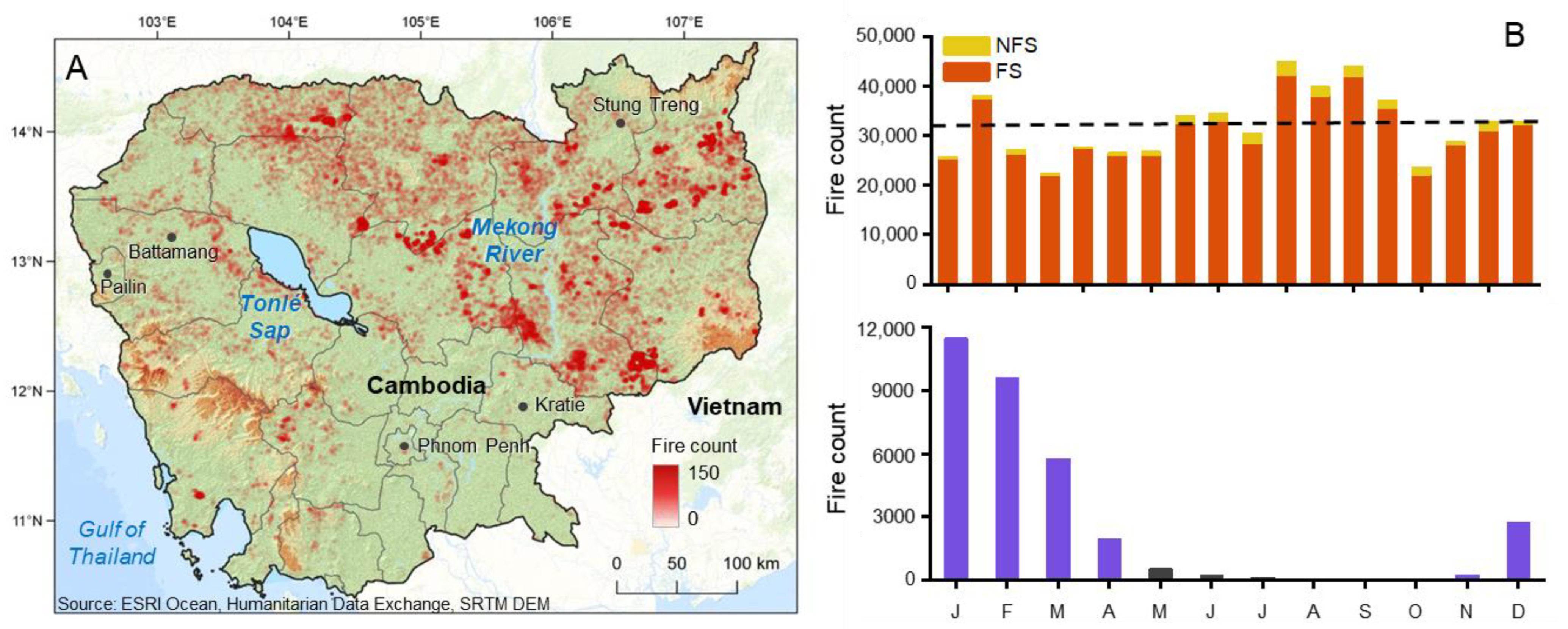
2.2. Dependent Variable: Spatiotemporal Distribution of Fire
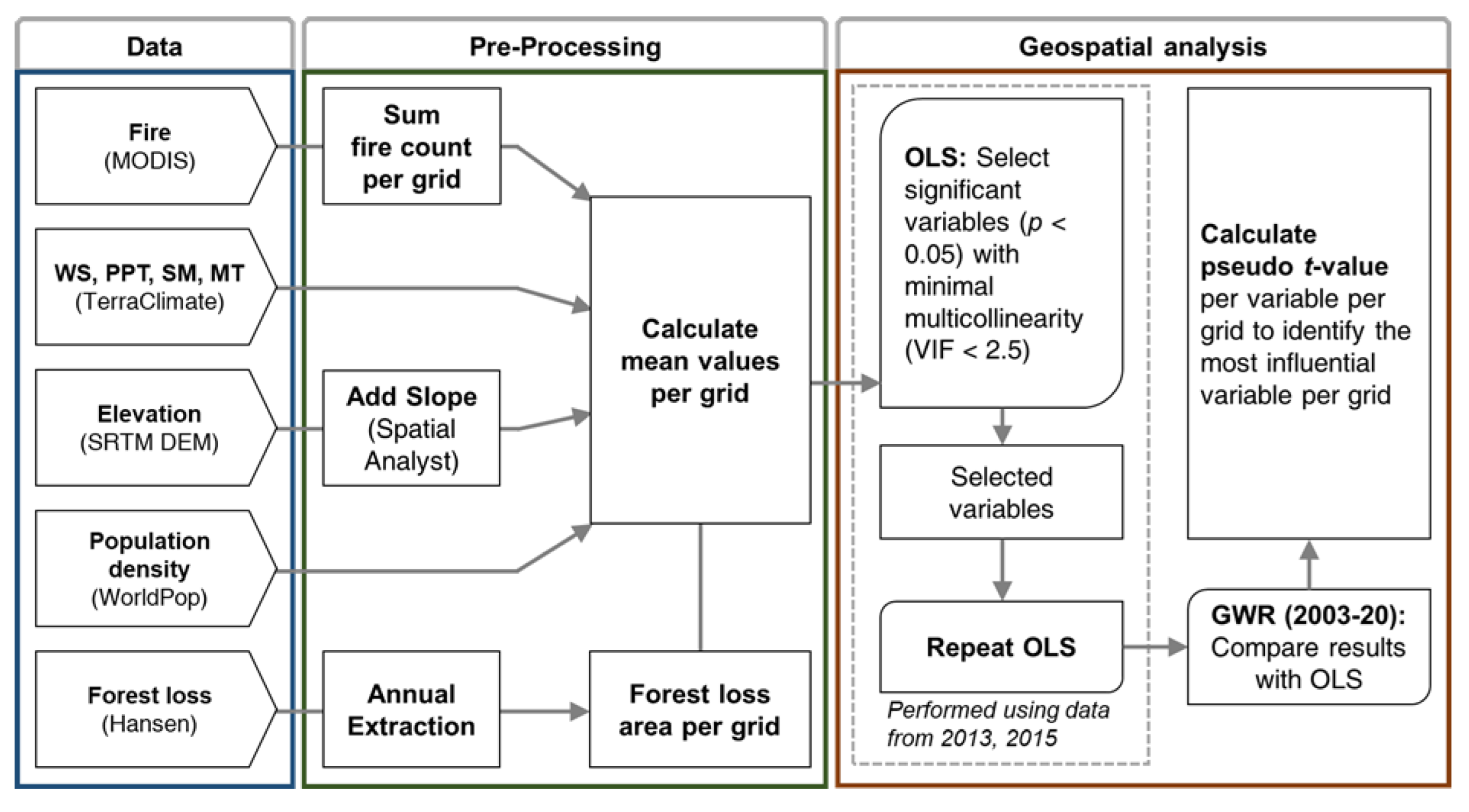
2.3. Explanatory Variables: Identification, Filtering and Pre-Processing
2.4. Identifying Significant Drivers of Wildfire Using OLS
2.5. Geographically Weighted Regression (GWR)
3. Results
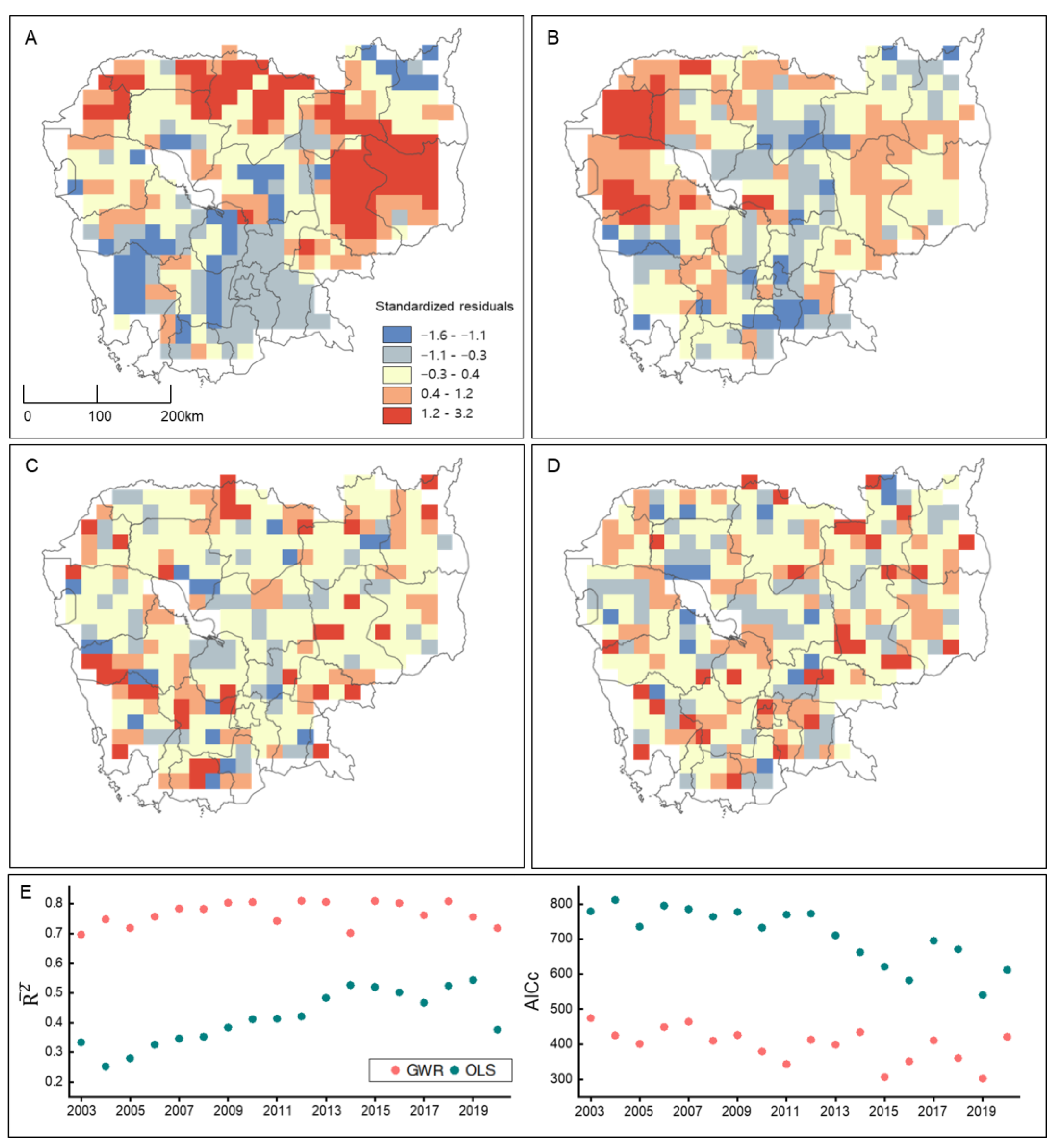
3.1. Analysis of OLS Regression and GWR for Model Validity
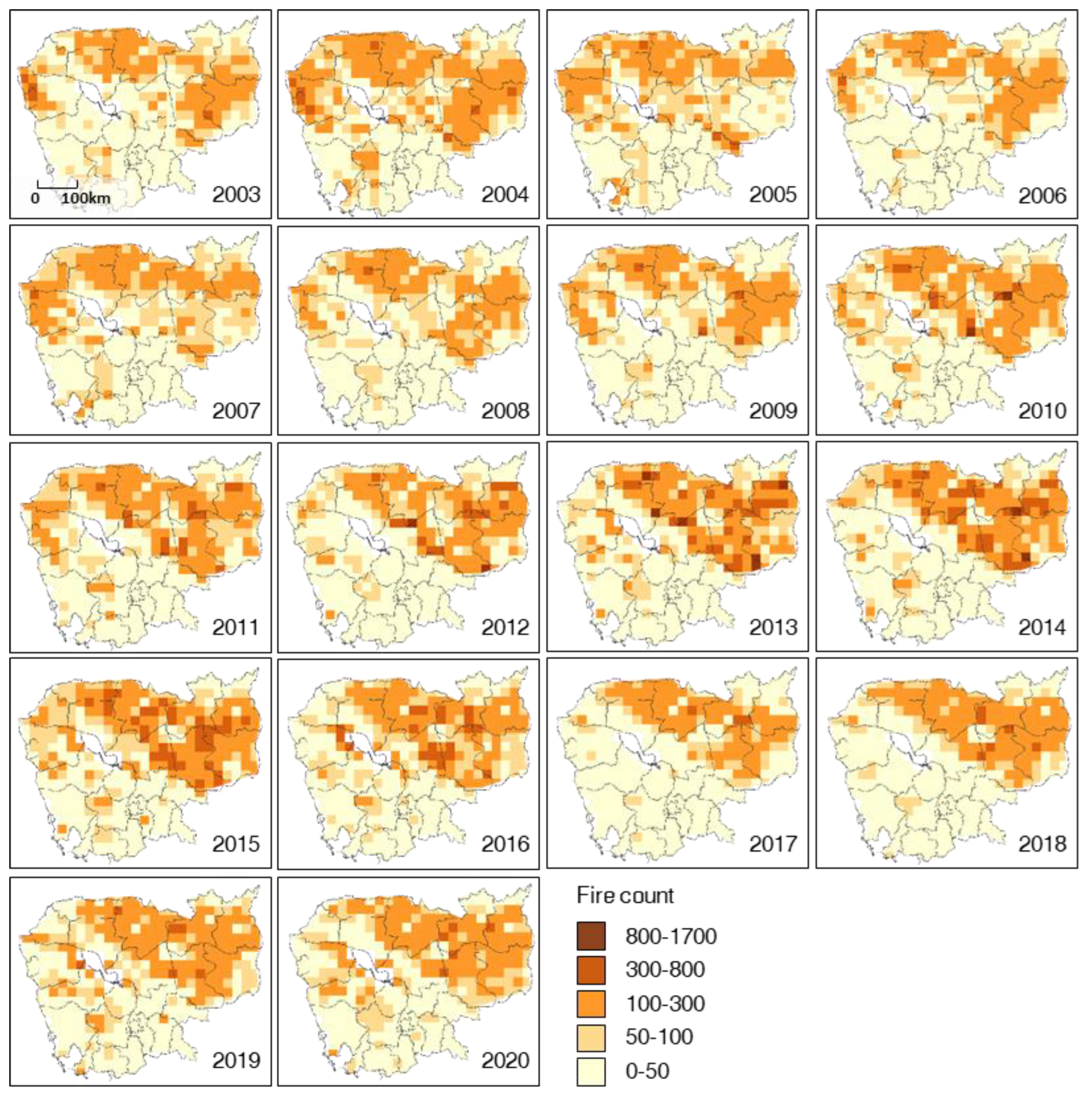
3.2. Spatiotemporal Evolution of Fire Activity
3.3. The Relative Influence of Each Driver of Fire
4. Discussion
4.1. Model Validation for the Quantitative Analysis of Fire Drivers
4.2. Dominant Drivers of Wildfire in Cambodia
5. Summary
Author Contributions
Funding
Data Availability Statement
Acknowledgments
Conflicts of Interest
References
- Coogan, S.C.; Robinne, F.; Jain, P.; Flannigan, M.D. Scientists’ warning on wildfire—A Canadian perspective. Can. J. For. Res. 2019, 49, 1015–1023. [Google Scholar] [CrossRef] [Green Version]
- Jolly, W.M.; Cochrane, M.A.; Freeborn, P.H.; Holden, Z.A.; Brown, T.J.; Williamson, G.J.; Bowman, D.M.J.S. Climate-induced variations in global wildfire danger from 1979 to 2013. Nat. Commun. 2015, 6, 7537. [Google Scholar] [CrossRef] [PubMed] [Green Version]
- Wright, J.L.; Roy, S.S. Geospatial characteristics of Colorado wildfire occurrences from 2001 to 2020. Remote Sens. Appl. Soc. Environ. 2022, 28, 100872. [Google Scholar] [CrossRef]
- Govender, N.; Trollope, W.S.; Van Wilgen, B.W. The effect of fire season, fire frequency, rainfall and management on fire intensity in savanna vegetation in South Africa. J. Appl. Ecol. 2006, 43, 748–758. [Google Scholar] [CrossRef]
- Wan, C.; Roy, S.S. Geospatial characteristics of fire occurrences in southern hemispheric Africa and Madagascar during 2001–2020. J. For. Res. 2022, 34, 553–563. [Google Scholar] [CrossRef]
- Abdollahi, M.; Dewan, A.; Hassan, Q.K. Applicability of remote sensing-based vegetation water content in modeling lightning-caused Forest fire occurrences. ISPRS Int. J. Geo-Inf. 2019, 8, 143. [Google Scholar] [CrossRef] [Green Version]
- Oliveira, S.; Oehler, F.; San-Miguel-Ayanz, J.; Camia, A.; Pereira, J.M. Modeling spatial patterns of fire occurrence in Mediterranean Europe using Multiple Regression and Random Forest. For. Ecol. Manag. 2012, 275, 117–129. [Google Scholar] [CrossRef]
- De Sales, F.; Okin, G.S.; Xue, Y.; Dintwe, K. On the effects of wildfires on precipitation in Southern Africa. Clim. Dyn. 2019, 52, 951–967. [Google Scholar] [CrossRef] [Green Version]
- Wei, F.; Wang, S.; Fu, B.; Brandt, M.; Pan, N.; Wang, C.; Fensholt, R. Nonlinear dynamics of fires in Africa over recent decades controlled by precipitation. Glob. Chang. Biol. 2020, 26, 4495–4505. [Google Scholar] [CrossRef]
- Singh, M.; Sood, S.; Collins, C.M. Fire Dynamics of the Bolivian Amazon. Land 2022, 11, 1436. [Google Scholar] [CrossRef]
- Ying, L.; Han, J.; Du, Y.; Shen, Z. Forest fire characteristics in China: Spatial patterns and determinants with thresholds. For. Ecol. Manag. 2018, 424, 345–354. [Google Scholar] [CrossRef]
- Johnston, F.H.; Henderson, S.B.; Chen, Y.; Randerson, J.T.; Marlier, M.; DeFries, R.S.; Kinney, P.; Bowman, D.M.J.S.; Brauer, M. Estimated global mortality attributable to smoke from landscape fires. Environ. Health Perspect. 2012, 120, 695–701. [Google Scholar] [CrossRef] [PubMed] [Green Version]
- Swaine, M.D. Characteristics of dry forest in West Africa and the influence of fire. J. Veg. Sci. 1992, 3, 365–374. [Google Scholar] [CrossRef]
- Vadrevu, K.P.; Lasko, K.; Giglio, L.; Schroeder, W.; Biswas, S.; Justice, C. Trends in vegetation fires in south and southeast Asian countries. Sci. Rep. 2019, 9, 7422. [Google Scholar] [CrossRef] [Green Version]
- Ministry Warns of Upcoming Dry Season That Can Spark Wildfires. Available online: https://www.khmertimeskh.com/501005100/ministry-warns-of-upcoming-dry-season-that-can-spark-wildfires/ (accessed on 17 May 2023).
- Jones, S.H. Vegetation fire and land use in Southeast Asia: The interpretation of remotely sensed data for Cambodia. Geocarto Int. 1998, 13, 63–73. [Google Scholar] [CrossRef]
- MacInnes, M. Governing the Flame: Bunong Management of Fire Regimes in Mondulkiri Province, Northeast Cambodia. In Proceedings of the FORTROP II Tropical Forestry Change in a Changing World, Bangkok, Thailand, 17–20 November 2008; pp. 124–131. [Google Scholar]
- Mermoz, S.; Bouvet, A.; Koleck, T.; Ballère, M.; Le Toan, T. Continuous Detection of Forest Loss in Vietnam, Laos, and Cambodia Using Sentinel-1 Data. Remote Sens. 2021, 13, 4877. [Google Scholar] [CrossRef]
- Rainey, H.; Bauran, H.; Evans, T. Forest Cover Trends in the Northern Plains of Cambodia 2002–2010; Wildlife Conservation Society: Phnom Penh, Cambodia, 2010. [Google Scholar]
- Thach, N.N.; Ngo, D.B.-T.; Xuan-Canh, P.; Hong-Thi, N.; Thi, B.H.; Nhat-Duc, H.; Dieu, T.B. Spatial pattern assessment of tropical forest fire danger at Thuan Chau area (Vietnam) using GIS-based advanced machine learning algorithms: A comparative study. Ecol. Inform. 2018, 46, 74–85. [Google Scholar] [CrossRef]
- Abid, F. A survey of machine learning algorithms based forest fires prediction and detection systems. Fire Technol. 2021, 57, 559–590. [Google Scholar] [CrossRef]
- Chang, Y.; Zhu, Z.; Bu, R.; Chen, H.; Feng, Y.; Li, Y.; Hu, Y.; Wang, Z. Predicting fire occurrence patterns with logistic regression in Heilongjiang Province, China. Landsc. Ecol. 2013, 28, 1989–2004. [Google Scholar] [CrossRef]
- Fujioka, F.M.; Gill, A.M.; Viegas, D.X.; Wotton, B.M. Fire danger and fire behavior modeling systems in Australia, Europe, and North America. Dev. Environ. Sci. 2008, 8, 471–497. [Google Scholar]
- Tonini, M.; Gill, A.M.; Viegas, D.X.; Wotton, B.M. A machine learning-based approach for wildfire susceptibility mapping. The case study of the Liguria region in Italy. Geosciences 2020, 10, 105. [Google Scholar] [CrossRef] [Green Version]
- Li, W.; Xu, Q.; Yi, J.; Liu, J. Predictive model of spatial scale of forest fire driving factors: A case study of Yunnan Province, China. Sci. Rep. 2022, 12, 19029. [Google Scholar] [CrossRef] [PubMed]
- Van Touch, R.M. Simulation Modelling of Alternative Strategies for Climate Change Adaptation in Rainfed Cropping Systems in North-Western Cambodia; Wrest Point Convention Centre: Hobart, Tasmania, 2015. [Google Scholar]
- Giglio, L.; Schroeder, W.; Justice, C.O. The collection 6 MODIS active fire detection algorithm and fire products. Remote Sens. Environ. 2016, 178, 31–41. [Google Scholar] [CrossRef] [PubMed] [Green Version]
- Piñol, J.; Terradas, J.; Lloret, F. Climate warming, wildfire hazard, and wildfire occurrence in coastal eastern Spain. Clim. Chang. 1998, 38, 345–357. [Google Scholar] [CrossRef]
- Krueger, E.S.; Ochsner, T.E.; Engle, D.M.; Carlson, J.; Twidwell, D.; Fuhlendorf, S.D. Soil moisture affects growing-season wildfire size in the southern Great Plains. Soil Sci. Soc. Am. J. 2015, 79, 1567–1576. [Google Scholar] [CrossRef] [Green Version]
- Williams, A.P.; Abatzoglou, J.T.; Gershunov, A.; Guzman-Morales, J.; Bishop, D.A.; Balch, J.K.; Lettenmaier, D.P. Observed impacts of anthropogenic climate change on wildfire in California. Earth’s Future 2019, 7, 892–910. [Google Scholar] [CrossRef] [Green Version]
- Beer, T. The interaction of wind and fire. Bound.-Layer Meteorol. 1991, 54, 287–308. [Google Scholar] [CrossRef]
- Abatzoglou, J.T.; Dobrowski, S.Z.; Parks, S.A.; Hegewisch, K.C. TerraClimate, a high-resolution global dataset of monthly climate and climatic water balance from 1958–2015. Sci. Data 2018, 5, 170191. [Google Scholar] [CrossRef] [Green Version]
- Sze, J.S.; Lee, J.S.H. Evaluating the social and environmental factors behind the 2015 extreme fire event in Sumatra, Indonesia. Environ. Res. Lett. 2019, 14, 015001. [Google Scholar] [CrossRef]
- Wharton, C.H. Man, fire and wild cattle in Southeast Asia. In Proceedings of the Annual Tall Timbers Fire Ecology Conference Series 8; Tall Timbers: Tallahassee, FL, USA, 1968. [Google Scholar]
- Satir, O.; Berberoglu, S.; Donmez, C. Mapping regional forest fire probability using artificial neural network model in a Mediterranean forest ecosystem. Geomat. Nat. Hazards Risk 2016, 7, 1645–1658. [Google Scholar] [CrossRef] [Green Version]
- Berry, P.; Garlick, J.D.; Smith, R.G. Near-global validation of the SRTM DEM using satellite radar altimetry. Remote Sens. Environ. 2007, 106, 17–27. [Google Scholar] [CrossRef]
- Yin, S. Biomass burning spatiotemporal variations over South and Southeast Asia. Environ. Int. 2020, 145, 106153. [Google Scholar] [CrossRef] [PubMed]
- Tatem, A.J. WorldPop, open data for spatial demography. Sci. Data 2017, 4, 170004. [Google Scholar] [CrossRef] [PubMed]
- Hansen, M.C.; Potapov, P.V.; Moore, R.; Hancher, M.; Turubanova, S.A.; Tyukavina, A.; Thau, D.; Stehman, S.V.; Goetz, S.J.; Loveland, T.R.; et al. High-resolution global maps of 21st-century forest cover change. Science 2013, 342, 850–853. [Google Scholar] [CrossRef] [PubMed] [Green Version]
- Tulbure, M.G.; Wimberly, M.C.; Roy, D.P.; Henebry, G.M. Spatial and temporal heterogeneity of agricultural fires in the central United States in relation to land cover and land use. Landsc. Ecol. 2011, 26, 211–224. [Google Scholar] [CrossRef]
- Oliveira, S.; Pereira, J.M.C.; San-Miguel-Ayanz, J.; Lourenço, L. Exploring the spatial patterns of fire density in Southern Europe using Geographically Weighted Regression. Appl. Geogr. 2014, 51, 143–157. [Google Scholar] [CrossRef]
- Parajuli, A.; Gautam, A.P.; Sharma, S.P.; Bhujel, K.B.; Sharma, G.; Thapa, P.B.; Bist, B.S.; Poudel, S. Forest fire risk mapping using GIS and remote sensing in two major landscapes of Nepal. Geomat. Nat. Hazards Risk 2020, 11, 2569–2586. [Google Scholar] [CrossRef]
- O’brien, R.M. A caution regarding rules of thumb for variance inflation factors. Qual. Quant. 2007, 41, 673–690. [Google Scholar] [CrossRef]
- Fotheringham, A.S.; Brunsdon, C.; Charlton, M. Geographically Weighted Regression: The Analysis of Spatially Varying Relationships; John Wiley & Sons: Hoboken, NJ, USA, 2003. [Google Scholar]
- Rodrigues, M.; de la Riva, J.; Fotheringham, S. Modeling the spatial variation of the explanatory factors of human-caused wildfires in Spain using geographically weighted logistic regression. Appl. Geogr. 2014, 48, 52–63. [Google Scholar] [CrossRef]
- Fires-in-Cambodia. Available online: https://earthobservatory.nasa.gov/images/48859/fires-in-cambodia (accessed on 17 May 2023).
- Lohani, S.; Dilts, T.E.; Weisberg, P.J.; Null, S.E.; Hogan, Z.S. Rapidly accelerating deforestation in Cambodia’s Mekong River Basin: A comparative analysis of spatial patterns and drivers. Water 2020, 12, 2191. [Google Scholar] [CrossRef]
- Sourn, T.; Pok, S.; Chou, P.; Nut, N.; Theng, D.; Rath, P.; Reyes, M.R.; Prasad, P.V. Evaluation of land use and land cover change and its drivers in Battambang Province, Cambodia from 1998 to 2018. Sustainability 2021, 13, 11170. [Google Scholar] [CrossRef]
- Mekong Countries Urged to Take Bold Actions, as the River Experiences Three Consecutive Years of Low Flows. Available online: https://www.mrcmekong.org/news-and-events/news/pr-13-1-2022/ (accessed on 17 May 2023).
- Cambodia–Floods. Available online: https://reliefweb.int/report/cambodia/cambodia-floods-cambodia-meteo-aha-centre-media-echo-daily-flash-20-september-2019 (accessed on 17 May 2023).
- Valette, J.; Gomendy, V.; Maréchal, J.; Houssard, C.; Gillon, D. Heat-transfer in the soil during very low-intensity experimental fires-the role of duff and soil-moisture content. Int. J. Wildland Fire 1994, 4, 225–237. [Google Scholar] [CrossRef]
- Chaparro, D.; Vall-Llossera, M.; Piles, M.; Camps, A.; Rüdiger, C. Low soil moisture and high temperatures as indicators for forest fire occurrence and extent across the Iberian Peninsula. In Proceedings of the 2015 IEEE International Geoscience and Remote Sensing Symposium (IGARSS), Milan, Italy, 26–31 July 2015. [Google Scholar]
- Curtis, P.G.; Slay, C.M.; Harris, N.L.; Tyukavina, A.; Hansen, M.C. Classifying drivers of global forest loss. Science 2018, 361, 1108–1111. [Google Scholar] [CrossRef] [PubMed]
- Tyukavina, A.; Potapov, P.; Hansen, M.C.; Pickens, A.H.; Stehman, S.V.; Turubanova, S.; Parker, D.; Zalles, V.; Lima, A.; Kommareddy, I.; et al. Global trends of Forest loss due to fire from 2001 to 2019. Front. Remote Sens. 2022, 3, 825190. [Google Scholar] [CrossRef]
| Category | Variable | Data Source | Unit | Resolution | |
|---|---|---|---|---|---|
| Meteorological variables | Wind speed | TerraClimate | m/s | 2003–2020 (Yearly) | 4 km |
| Precipitation | mm | ||||
| Maximum Temperature | °C | ||||
| Soil moisture | mm | ||||
| Topographic variables | Elevation | SRTM DEM | m | 2003–2020 (Yearly) | 30 m |
| Slope | ° | ||||
| Human variables | Forest loss | Global Land Analysis & Discovery (GLAD) | % | 2003–2020 (Yearly) | 30 m |
| Population density | WorldPop | % | 2003–2020 (Yearly) | 30 arc-seconds (1 km) | |
| Variable | Std Coef. | StdError | t-Statistic | p-Value | VIF | Std Coef. | StdError | t-Statistic | p-Value | VIF |
|---|---|---|---|---|---|---|---|---|---|---|
| 2013 | 2015 | |||||||||
| Wind speed | 0.186 | 0.009 | 2.052 | 0.040 ** | 1.22 | −0.132 | 0.080 | −3.908 | 0.000 ** | 1.17 |
| Precipitation | −0.367 | 0.111 | −5.667 | 0.000 ** | 1.18 | −0.173 | 0.031 | −2.385 | 0.017 ** | 1.14 |
| Soil moisture | −0.198 | 0.179 | −2.509 | 0.012 ** | 1.31 | −0.421 | 0.179 | −2.350 | 0.019 ** | 1.44 |
| Forest loss | 0.524 | 0.057 | 22.320 | 0.000 ** | 1.16 | 0.405 | 0.108 | 3.726 | 0.000 ** | 1.11 |
| Elevation | 0.224 | 0067 | 3.774 | 0.000 ** | 1.33 | 0.335 | 0.006 | 3.526 | 0.001 ** | 1.10 |
Disclaimer/Publisher’s Note: The statements, opinions and data contained in all publications are solely those of the individual author(s) and contributor(s) and not of MDPI and/or the editor(s). MDPI and/or the editor(s) disclaim responsibility for any injury to people or property resulting from any ideas, methods, instructions or products referred to in the content. |
© 2023 by the authors. Licensee MDPI, Basel, Switzerland. This article is an open access article distributed under the terms and conditions of the Creative Commons Attribution (CC BY) license (https://creativecommons.org/licenses/by/4.0/).
Share and Cite
Sim, M.-S.; Wee, S.-J.; Alcantara, E.; Park, E. Deforestation as the Prominent Driver of the Intensifying Wildfire in Cambodia, Revealed through Geospatial Analysis. Remote Sens. 2023, 15, 3388. https://doi.org/10.3390/rs15133388
Sim M-S, Wee S-J, Alcantara E, Park E. Deforestation as the Prominent Driver of the Intensifying Wildfire in Cambodia, Revealed through Geospatial Analysis. Remote Sensing. 2023; 15(13):3388. https://doi.org/10.3390/rs15133388
Chicago/Turabian StyleSim, Min-Sung, Shi-Jun Wee, Enner Alcantara, and Edward Park. 2023. "Deforestation as the Prominent Driver of the Intensifying Wildfire in Cambodia, Revealed through Geospatial Analysis" Remote Sensing 15, no. 13: 3388. https://doi.org/10.3390/rs15133388
APA StyleSim, M.-S., Wee, S.-J., Alcantara, E., & Park, E. (2023). Deforestation as the Prominent Driver of the Intensifying Wildfire in Cambodia, Revealed through Geospatial Analysis. Remote Sensing, 15(13), 3388. https://doi.org/10.3390/rs15133388


