Article

Exploring the Spatial Relationship between the Ecological Topological Network and Carbon Sequestration Capacity of Coastal Urban Ecosystems: A Case Study of Yancheng City, China

1
College of Animal Science and Technology, Yangzhou University, Yangzhou 225000, China
2
College of Landscape Architecture, Fujian Agriculture and Forestry University, Fuzhou 350002, China
3
College of Horticulture and Landscape Architecture, Yangzhou University, Yangzhou 225000, China
*
Author to whom correspondence should be addressed.
Remote Sens. 2023, 15(16), 4007; https://doi.org/10.3390/rs15164007
Submission received: 13 June 2023 / Revised: 4 August 2023 / Accepted: 10 August 2023 / Published: 12 August 2023

Abstract

:
Improving the carbon sequestration capacity (CSC) of an ecosystem by optimizing urban ecological networks is one of the effective ways to achieve the goal of “carbon neutrality” in the world. The contradiction between the irreplaceable ecological function and economic development of Yancheng City is prominent. Therefore, taking Yancheng City as an example, this paper adopted the morphological spatial pattern analysis–minimum cumulative resistance (MSPA-MCR) model to establish the ecological network of Yancheng City in 2020 and combined it with complex network theory to evaluate its ecological base, network quality, and CSC. The results show that the ecological network of Yancheng City has obvious characteristics of coastal cities. There is a significant positive correlation between CSC and the clustering efficiency of ecological sources, and improving the clustering efficiency of vegetation and water ecological nodes is conducive to enhancing the CSC of ecological networks. In terms of functional restoration of ecological networks, four types of 13 ecological stepping stones and 12 ecological corridors have been designed to strengthen the connectivity and balance of the network, and the improvement of network robustness before and after optimization verifies that the optimization scheme is reasonable and effective. This study improved the optimization method of ecological networks in Yancheng City based on enhancing the CSC of ecological nodes, which provided a theoretical framework and practical reference for the realization of global strategic goals of carbon neutrality.

1. Introduction

In 2009, an evaluation report on the carbon sequestration capacity (CSC) of healthy oceans issued by the United Nations Environment Programme pointed out that about 55% of carbon sequestrated by natural ecosystems worldwide was captured and stored by coastal ecosystems. Coastal zones, as an important component of natural resources, have higher storage density and longer storage time, which have a broad prospect for carbon sequestration [1]. Therefore, the improvement of CSC of ecosystems in coastal cities is significant to realize the ambitious goal of “carbon neutrality” [2].
Governments around the world have made tremendous efforts to improve the CSC of coastal cities and have sought different solutions [3,4,5,6]. In recent years, scholars have conducted a large number of studies on various ecosystems, different regions, and global scales, indicating that urban ecological space is the only direct carbon sequestration resource within a city, and its CSC on a large scale is closely related to natural environmental factors and land-use types [7]. Habitat fragmentation and land use transformation caused by the urban development process are considered to be the most important factors in reducing the CSC of regional ecosystems [8]. Ecological networks can help comprehensively describe ecological processes, protect habitats, and maintain landscape connectivity [9,10,11]. More and more researchers combine ecological network construction with the improvement of the CSC of ecosystems [12,13].
The ecological network has been a hot topic in the field of landscape ecology recently, including relevant studies on regional ecological patterns and ecosystem optimization [14]. ArcGIS provides a research platform that integrates regional environmental change and in-depth analysis [15,16]. Researchers establish a network composed of regional landscape patches on the GIS platform, which is called an ecological spatial network or ecological network [17,18]. Ecological network regards important landscape elements (such as core areas and nature reserves) as ecological nodes and considers linear channels connecting ecological nodes as ecological corridors, coupling landscape structures, ecological processes, and functions together [19]. The construction method of the ecological spatial network is very mature. The mainstream research paradigm of ecological source–ecological resistance surface–ecological corridor has initially formed [20]. Various remote sensing data and morphological spatial pattern analysis (MSPA) analysis, integrated valuation of ecosystem services and trade-offs (InVEST) model, minimum cumulative resistance (MCR) model, circuit theoretical model, etc., are used to realize it [12]. The essence of an ecological spatial network is the abstraction and simplification of spatial topological structures in landscape patches [21]. The establishment of ecological networks of regional ecosystems is essential for subsequent research on landscape dynamics, ecological security pattern construction, landscape risk assessment, and landscape heterogeneity analysis [22,23,24]. The ecological network identification method combining MSPA analysis and the MCR model is currently widely used, highly universal, and recognized in the industry [20].
Currently, in terms of carbon source and sequestration in ecosystems, research has mostly focused on carbon sequestration dynamics of forests [25], soils [26], or biological carbon sequestration at the species level [27]. However, few researchers have applied ecological networks to the spatial differentiation of CSC of urban ecosystems, which may be related to the difficulties in quantifying geographical spatial location and ecological network characteristics [28]. Some scholars have introduced complex network theory to visualize ecological networks as “point-line” undirected networks and combined topological indicators to characterize the relative spatial relationship among various ground objects. Scholars construct China’s forest and grass ecological network and analyze the correlation among topological indicators, water retention, soil conservation, and carbon storage. Moreover, the internal relationship between the structural characteristics of ecological spatial networks and ecosystem services is clarified [29]. The estimation of carbon sequestration amount (CSA) of ecosystems in large regions is mainly carried out by two methods: measurement of net primary productivity (NPP) and net ecosystem productivity (NEP), estimation of carbon sequestration coefficient. NPP and NBP are used to measure CSC at forest and grassland ecological nodes in the Yellow River basin, and an optimization strategy of adding ecological corridors between forest and grassland ecological network nodes is proposed [14]. However, the measurement of CSC is limited to vegetation and cultivated land, which lacks water body data. Therefore, it is inappropriate to use them for research in coastal and dense water network areas. Carbon sequestration coefficients are taken to estimate the CSA of forest land, grassland, and water ecological nodes in the ecological network of Xuzhou City [30]. However, when the carbon sequestration coefficient (0.87 t ha−1) of forest land derived from the average statistics of carbon sequestration in China’s forest ecosystem between 2001 and 2010 is used to estimate CSA in the ecological source areas of Xuzhou, there is a significant error [31]. Reasonable optimization of ecological networks can effectively improve service functions of the ecosystem, including CSC [32].
Yancheng City, along the eastern coast of China, has the largest and best-preserved coastal mudflat wetland. It has an important ecological status all over the world [33]. As China’s “golden coast”, it maintains a variety of endangered plants and precious animals on the IUCN Red List. Most importantly, it is an irreplaceable supply station and habitat for migratory birds on the East Asian–Australasian migration route and the world’s largest wintering area for Grus japonensis. Under the trend of ecological globalization, the ecological restoration and functional repair of Yancheng City’s ecosystems are important works to maintain urban ecological health.
However, urbanization, construction, and economic development have also brought ecological problems to Yancheng City, such as low forest coverage, habitat fragmentation, high carbon emissions, wetland degradation, excessive reclamation, and fishing [34]. This has brought a great crisis to urban ecological quality and wetland protection. Goals of carbon neutrality and peak carbon dioxide emissions, irreplaceable ecological functions, and relatively scarce land resources require Yancheng City to comprehensively coordinate ecological resources in water areas, wetlands, plant resources, etc. In addition, ecological networks are also required to build and optimize; the CSC of the urban ecosystem while developing the economy needs to be enhanced; and a balance between resource protection and development and utilization must be achieved.
In the context of achieving goals of peak carbon dioxide emissions and carbon neutrality around the world, this study aims to improve the habitat and CSC of coastal cities through restoration and optimization of ecological networks, which provides a certain reference for the green space planning and layout of coastal cities with degraded habitat and unbalanced ecological network construction. In this study, Yancheng City was selected as a typical case. Multiple remote sensing data atlases and the MSPA-MCR model were used to construct Yancheng City’s ecological network in 2020 and evaluate its comprehensive spatial representation. Topological indicators and CSC of ecological network nodes were calculated, and their correlation was analyzed. The ecological network was optimized from the perspective of ecosystem function optimization and CSC improvement of ecological nodes. Optimization results were then verified by calculating the robustness of the network before and after optimization. How to balance urban spatial development and ecosystem stability is a key issue in the development process of Yancheng City and even the world’s other cities. This study has important practical and practical significance for the optimization of ecological networks, the improvement of CSC of coastal cities around the world, and the coordinated development of urban construction, development, and protection.

2. Study Area and Data Sources

2.1. Study Area

The study area, Yancheng City, China, has a total area of 6340 km2 (Figure 1). It is a typical coastal city, and the total length of its coastline is 582 km, accounting for 61% of Jiangsu Province’s. Among them, its coastal beach is 444 km in length, which is the longest in China, and its beach area reaches 683 ha, accounting for one-seventh of China [35]. Therefore, the regulation of the ocean on the urban climate is very significant. It belongs to the transition zone from the northern subtropical climate to the southern warm temperate climate (Yancheng City Bureau of Statistics 2021).

2.2. Data Sources and Preprocessing

In Table 1, multiple datasets (accessed on 10 March 2022) from 2020 were listed, including socioeconomic statistics and geospatial information used for analysis. The spatial resolution of LULC data of the study area was 10 × 10 m. According to its landscape base and study purposes, the land use was divided into eight types: woodland, shrub, grassland, wetland, farmland, water area, artificial surface, and bare land. And other datasets were reclassified to the same spatial resolution as LULC data.

3. Methods

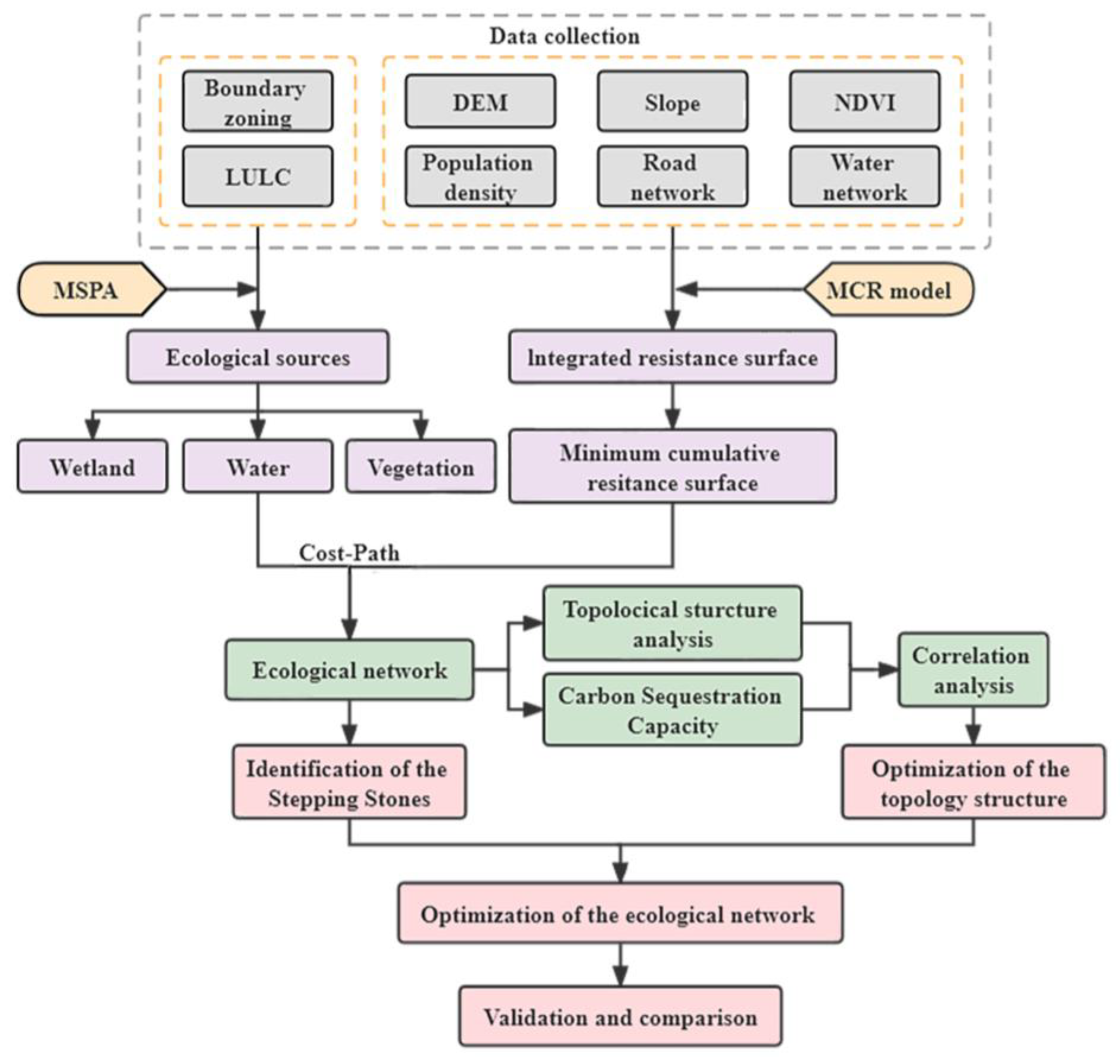
In Figure 2, the framework of this study was mainly divided into the following three parts.
(1) Establishment of ecological network based on MSPA-MCR model. According to MSPA method and landscape connectivity index, important ecological habitat patches were identified as ecological sources at the pixel level. Combined with multiple resistance factors, such as natural and anthropogenic disturbance factors, the MCR model was then modified. The minimum cumulative ecological resistance surface was calculated later. The ecological corridor was identified, and the landscape ecological network of Yancheng City was finally constructed.
(2) Evaluation of ecological network. Ecological nodes and corridors were visualized as topological nodes and lines to form a topological network. The gravity model was adopted to evaluate the relative action intensity of ecological sources as well as the relative importance of ecological corridors. The carbon sequestration coefficient was used to estimate the CSC of ecological sources, and the correlation with topological nodes was then analyzed.
(3) Optimization and validation of ecological network. Ecological sources with weak ecological function or topological structure were screened out, and corresponding optimization schemes were proposed. The validity and rationality of optimized network were verified by comparing the robustness of ecological networks before and after optimization.

3.1. Construction of Ecological Network

3.1.1. Identification of Ecological Sources

MSPA analysis is widely used in landscape science to identify ecological sources. It has the advantages of accurate and specific evaluation, less data required, and visualization of analysis results. It was adopted to analyze the spatial characteristics of landscape patterns of LULC data in this study. Woodland, shrub, grassland, wetland, and water area with high ecological value and less human disturbance were considered as “foreground”, and the farmland, artificial land, and bare land were regarded as “background” [36]. Based on GuidosToolbox2.8 platform, the binary raster image was re-interpreted into seven landscape types through spatial morphological analysis, such as open and close operation: core, bridge, loop, branch, islet, edge, and perforation [37]. Definition and their ecological implication of seven landscape types are described in detail in Table S1.
Landscape connectivity reflects the exchange of material and energy and the intensity and frequency of circulation among various ecological sources, which can measure the function of ecological sources and the overall structure of its network. It is an important supplement to the MSPA method [38]. Probability of connectivity (PC) refers to the possibility of direct diffusion of ecological flows between two habitat patches, which is a representation of overall landscape connectivity at the landscape level [39]. When a patch is removed from the landscape pattern, the overall landscape structure will change, which is called the delta of PC (dPC). It is an index to measure the importance of patches. PC value ranges from 0 to 1; when it is higher, the connectivity between patches is stronger. And when the dPC value is larger, the patch is more important. The formulas are as follows [40]:
P C = i = 1 n j = 1 n a i a j p i j A L 2
d P C = P C P C r e m o v e P C × 100 ,
where n is the total number of patches, ai and aj are the area of patches i and j, respectively, p i j * is the maximum probability value of species diffusion between patches i and j, AL is the total area of the patches, and PCremove the calculation result of connectivity after removing a particular element.
Combined with the actual situation of study area and the relevant research, the importance degree of ecological source was quantified by software Conefor2.6 (http://www.Conefor.org/ (accessed on 29 October 2022)), and its distance threshold and connection probability were set as 1000 and 0.5, respectively. Habitat patches with dPC and areas greater than 0.26 and 3 km2, respectively, in the study area, were selected as important ecological sources. According to ecological function and dominant patch types, ecological sources were divided into three categories: vegetation, wetland, and water area [40].

3.1.2. Construction and Correction of Resistance Surface

MCR model, widely used in species conservation and landscape pattern analysis, is adopted to calculate the “accumulated cost” of “source” so as to overcome the “resistance” of outward spread [41].
Based on the combination of previous research in references [42,43] and actual situations of the study area, the assignment of resistance factor was carried out, and the AHP (Table S2) was adopted to determine the significance of each factor (Table S3). DEM, Slope, LULC, NDVI, and MSPA were taken to characterize resistance factors of regional natural ecological base. In addition, the degree of human disturbance was characterized by population density, distance from water, and road networks.

3.1.3. Extraction of Ecological Corridors

Through the overlapping analysis of ecological source and resistance surface, the minimum resistance path between the sources can be analyzed, that is, the potential ecological corridor. The calculation formula is expressed as follows:
V M C R = f m i n j = n i = m ( D i j × R i )
where Dij is the distance from patch i to j; Ri represents the resistance of material flow between habitat patches; VMCR is the MCR; and f is the positive correlation between the MCR and ecological process.
The ecological source and comprehensive resistance surface are selected to calculate the minimum cumulative cost distance between pixel and nearest unit on the cost surface based on ArcGIS and the cost distance module platform [44].

3.1.4. Determination of Importance of Ecological Corridors

The gravity model can quantify the interaction between ecological sources. The greater the interaction force, the more important the potential ecological corridor between ecological sources and the higher the construction priority [9]. In this study, the ecological sources with the top 50% of interaction intensity G value were used to construct corridors, and the threshold of their G value was set to 20 and 100. Among them, corridors with G values greater than 100 and between 20 and 100 were regarded as important and secondary important ecological corridors, respectively, and the rest were selected as general ones. The calculation formula is expressed as follows:
G i j = N i N j D i j 2 = [ 1 P i × l n ( S i ) ] [ 1 P j × l n ( S j ) ] ( L i j L m a x ) 2 = L m a x 2 l n S i l n S j L i j 2 P i P j
where Gij is the interaction intensity between ecological sources i and j; Ni and Nj are the corresponding weight values of sources i and j, respectively; Dij is the standardized resistance value of potential corridor between source areas; Pi and Pj are the average resistance values of ecological source i and j, respectively; Si and Sj are the areas of sources i and j, respectively; Lij is the corridor resistance value between sources i and j; and Lmax is the maximum resistance of corridors in the study area.

3.2. Topological Structure of Ecological Network

According to complex network and graph theories, ecological sources and corridors are abstracted as nodes and lines of network, respectively. Therefore, the ecological network can be visualized as a topological network [45]. In contrast, ecological topological network actually simplifies and quantifies the real spatial structure of landscape for better research. According to relevant research, 9 topological indicators are selected to evaluate the ecological network of Yancheng City. Among them, the overall structure of ecological topological network is represented by average degree, average clustering coefficient, and modularity; degree, betweenness centrality, closeness centrality, clustering coefficient, eigenvector centrality, and PageRank are used to evaluate the ecological sources and nodes [46]. These indicators are described in Table S4.

3.3. Estimation of CSA

Many scholars around the world calculate the CSA of different land uses. Based on China’s statistical data and related studies, the carbon sequestration coefficients of different regions are determined to estimate the CSA [31]. Although agricultural land has the potential of “carbon sequestration”, the CSC of China’s agriculture at the current stage cannot completely offset the greenhouse gases produced in the production process. Therefore, in this study, agricultural land was not calculated as a carbon source [30]. The calculation formula is as follows:
C t = i = 1 n A i S i
where Ct is the total amount of carbon sequestration; i is the land-use type; Ai is the land area of land-use type i; and Si is the sequestration coefficient of land-use type i (Table 2).
Table 2. Carbon sequestration coefficient for different land-use types.
Land-Use TypeCarbon Sequestration Coefficient (Mg C ha−1)Literature Sources
Vegetation *SoilTotal
Forest159.0124.9283.9[47,48,49]
Shrub43.1131.4174.5[50]
grassland11.5132.4143.8[51,52,53]
wetland15.3347.5362.8[54,55]
Water area/67.167.1[56,57]
* The vegetation carbon density includes litter and dead wood.

3.4. Verification of Robustness

Robustness is the ability of the system to maintain its basic function despite internal and external errors [58]. In natural system, the robustness of such network manifests itself as stability: when a “disaster” occurs, it is able to maintain basic function even if some of its components fail. According to relevant research, three indicators (average degree, efficiency, and connectivity robustness) were chosen to assess the robustness of ecological network nodes. These indicators are described in Table S5. The calculation of robustness before and after optimization is one of the significant methods to verify the effectiveness of network optimization.

4. Results

4.1. Construction and Analysis of Ecological Network

4.1.1. Identification of Ecological Sources

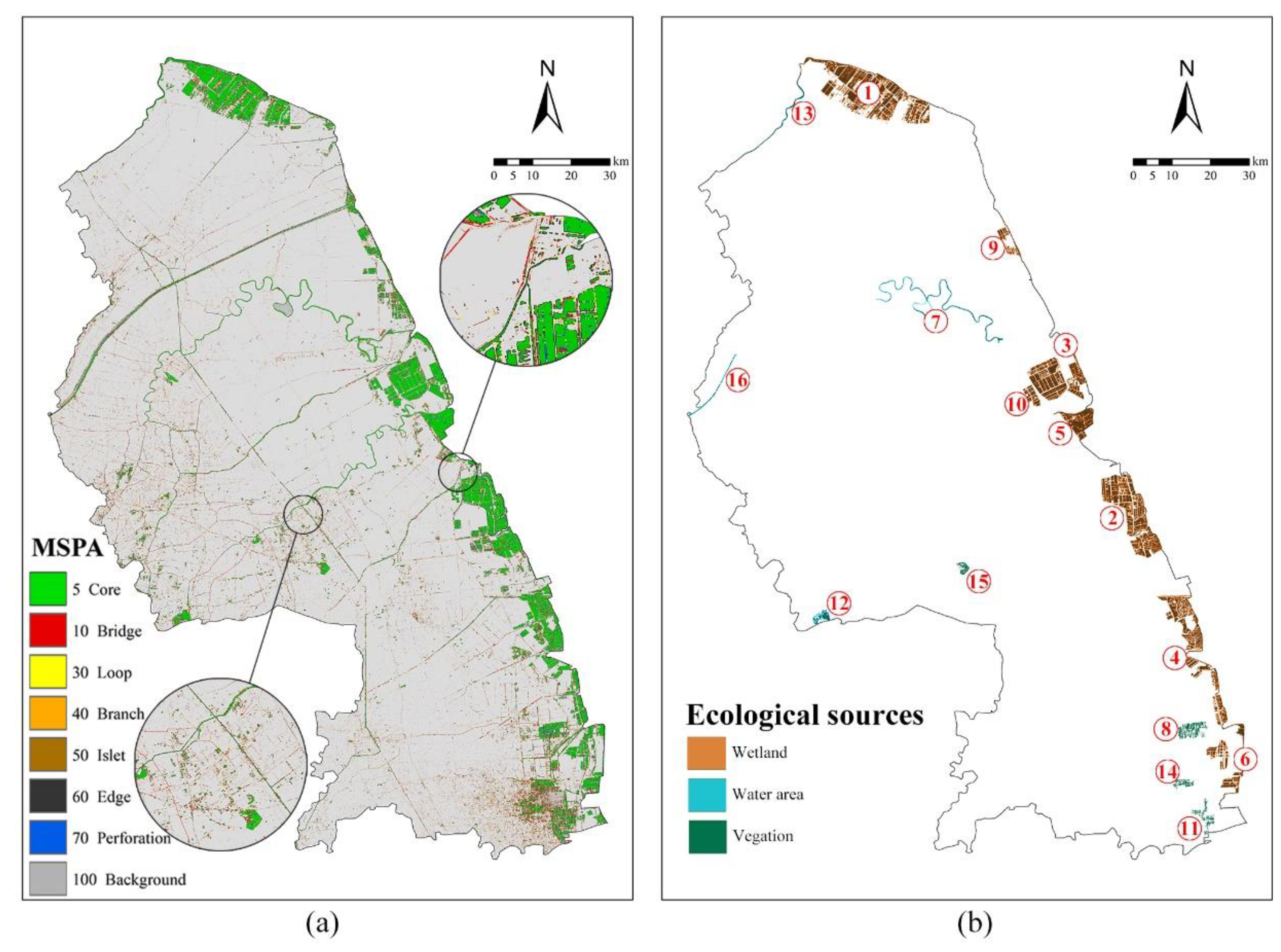
The LULC data of Yancheng City were processed by the MSPA method to obtain the landscape-type distribution map (Figure 3a). It is shown that the foreground area is 1614.63 km2 in the binary grid base map, only accounting for 10.41% of the total. Foreground elements were classified into seven landscape types, and the proportion of each type was detailed in Table 3.
dPC was used as an important indicator for ecological source selection to quantify the contribution degree of the core patch to the overall landscape connectivity. Sixteen ecological source plots with an area greater than 3 km2 and dPC values greater than 0.26 were obtained and numbered according to the source area, of which the land-use type with the highest proportion was classified into three categories (Figure 3b). In 16 ecological sources, large forests, national reserves, large coastal wetlands, river main flows, and eco-tourism areas of Yancheng City are all included.
Ecological sources are mainly wetlands and water areas, which fully show the characteristics of ecological spatial patterns in coastal areas. In addition, ecological sources are concentrated in the wetlands near the eastern coastline of the city and sparsely distributed in western and middle areas. It can be seen that the spatial distribution of ecological sources is obviously unbalanced.

4.1.2. Results of MCR Surface

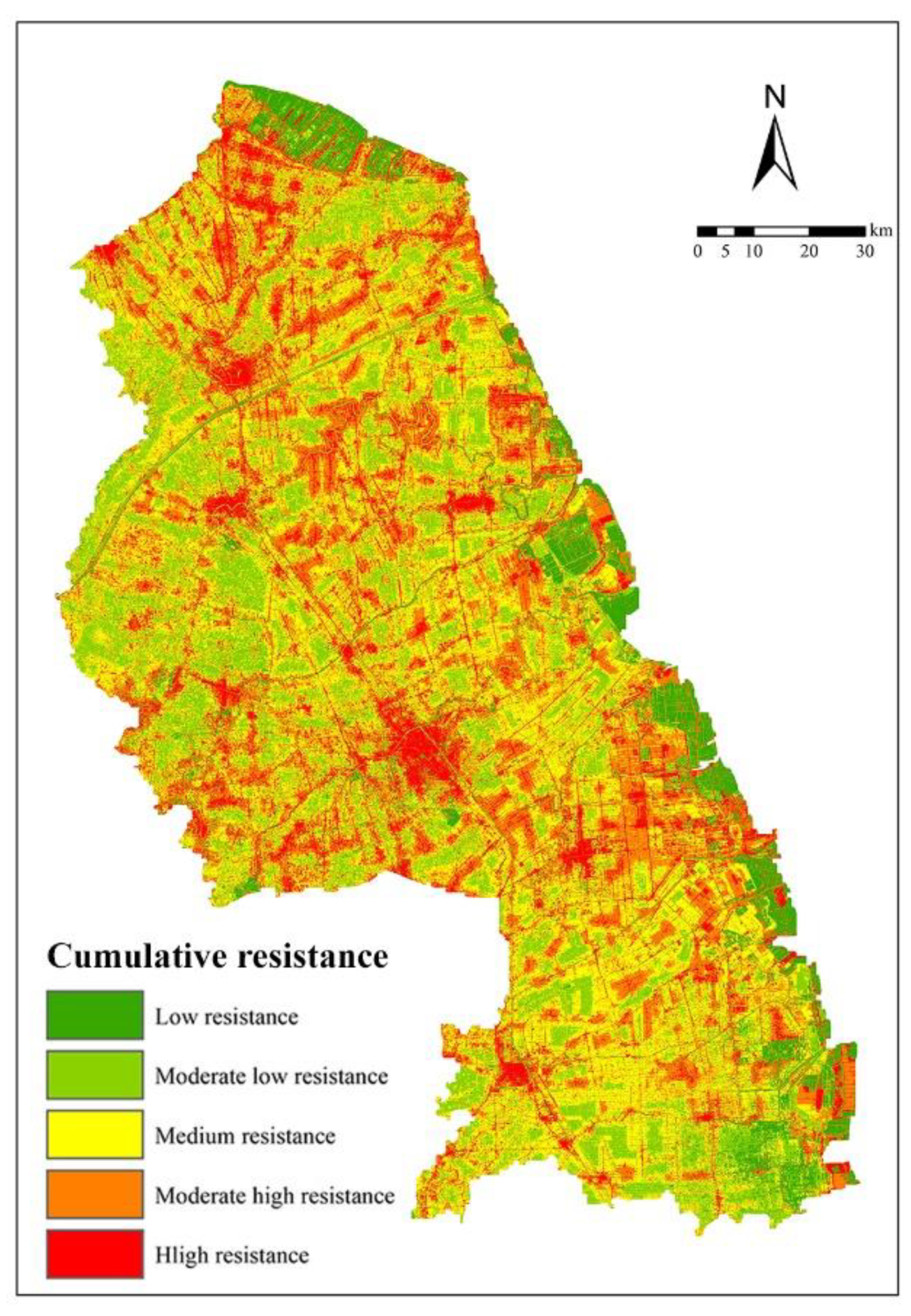
Based on the front resistance surface map (Figure S1), the ecological resistance surface map was obtained (Figure 4) and displayed in a hierarchical way according to the resistance value. The results show that Yancheng City has low resistance to ecological risks; among them, low-resistance area accounts for only 7.36% of the total, and moderate low-resistance area accounts for 17.15%; medium resistance area accounts for 35.61%, and moderate–high- and high-resistance areas account for 39.87%. The spatial distribution of resistance values shows that low-resistance area is similar to ecological sources, which is mainly concentrated in eastern coastal wetlands and scattered green spaces of the city; moderate–high- and high-resistance area are mainly urban construction area and artificial surface, while moderate low resistance area is mainly large farmland near the man-made surface; and medium resistance area accounts for a relatively high proportion in the study area, which has a certain ecological buffer function.

4.1.3. Analysis of Potential Ecological Corridors

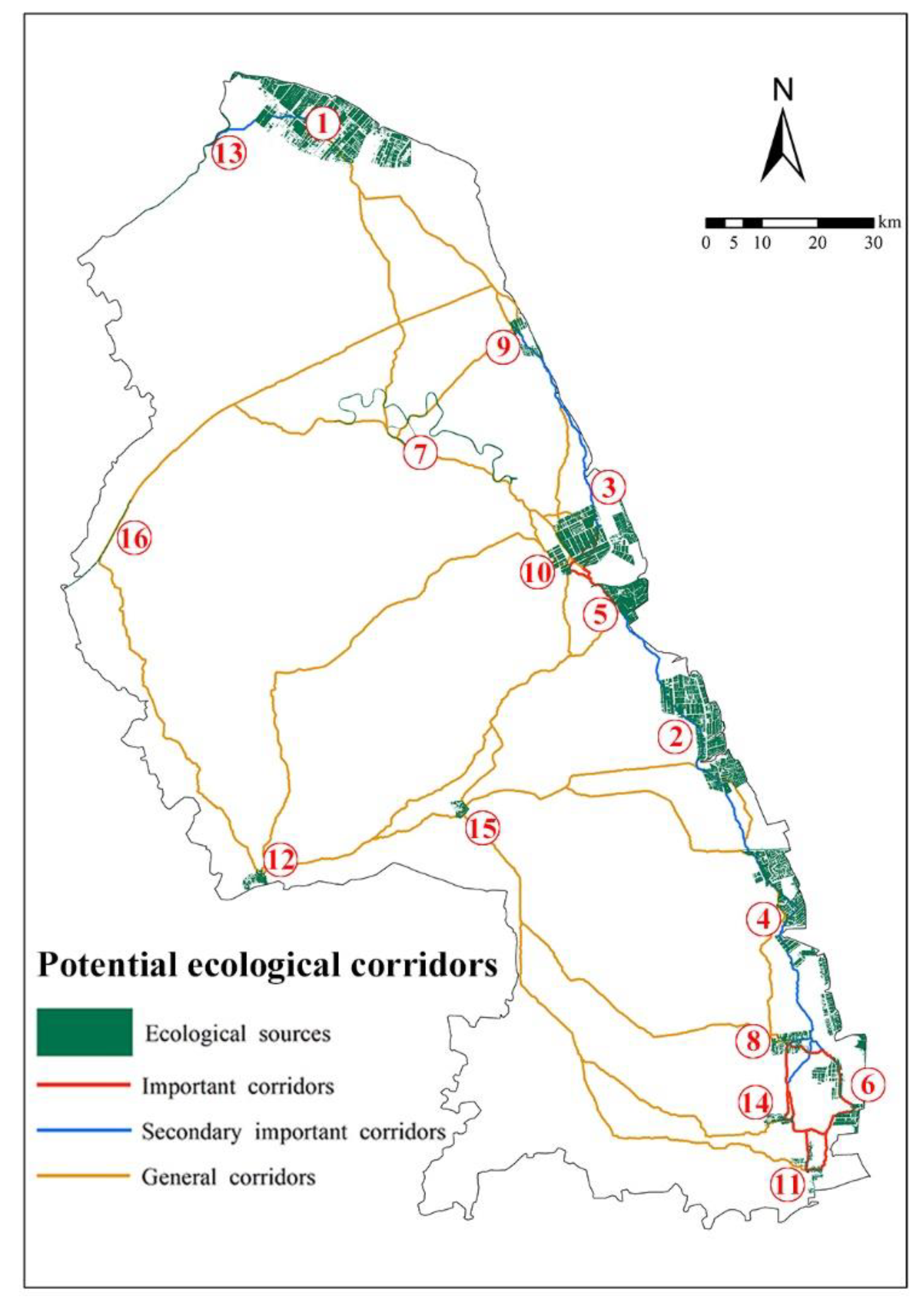
The Linkage Mapper component was used to construct a potential ecological corridor of Yancheng City by adopting the MCR model in ArcGIS. As shown in Figure 5, there are altogether 31 ecological corridors connecting 16 ecological sources in Yancheng City, which are mainly concentrated in coastal wetlands. A number of ecological corridors (7-10-12-15-11, etc.) are distributed along the tributaries of the city’s watershed. The gravity model was adopted to analyze the interaction intensity among various corridors, evaluate the significance of corridors and grade them. In this study, eight important, five secondary important, and eighteen general ecological corridors were obtained. The interaction matrix of the significance of ecological corridors is shown in Table S6.
Overall, ecological corridors in Yancheng City’s eastern coastal areas are obviously dense and short in length. However, there are only two north–south ecological corridors in the west, and almost all corridors are east–west in the central region. It can be seen that the ecological base of the study area is very poor, lacks a perfect ecological flow network, and has great room for improvement.

4.2. Analysis of Topological Structure

4.2.1. Evaluation of Overall Structure of Topological Network

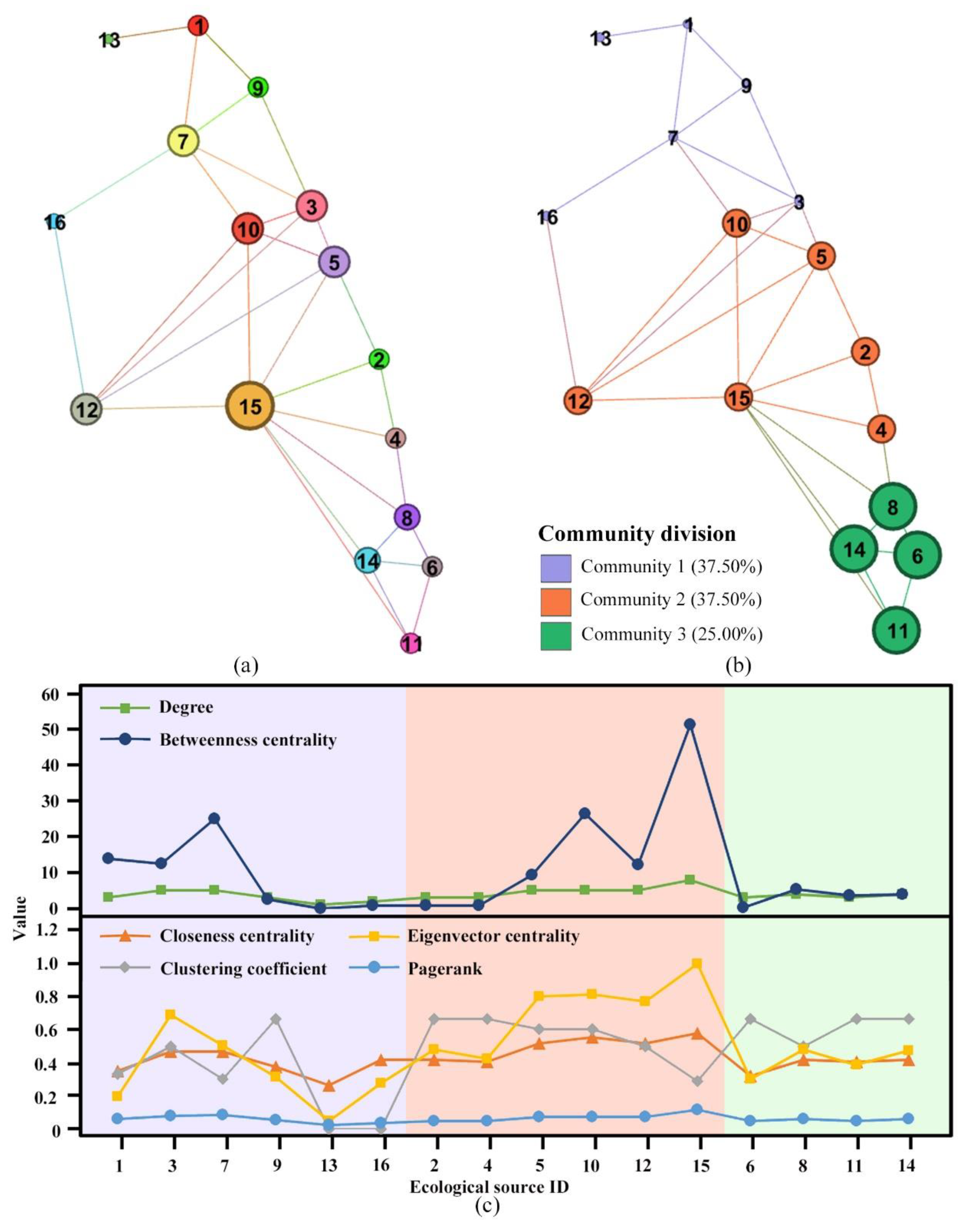
According to the complex network theory, ecological sources and corridors were introduced into the complex network visualization software Gephi 0.9.2 based on the JAVA platform in this study, and the topological network (Figure 6a) and modular division (Figure 6b) of the ecological network were obtained.
From the overall structure of the network, it is shown that the average degree and average clustering coefficient are 3.875, 6, and 0.508; by comparing with other studies, the average degree of ecological network in this study is lower, indicating that the average number of ecological corridors connected by ecological sources is smaller; the average clustering coefficient is also smaller, revealing that the aggregation of ecological nodes is clustered and unbalanced, most of ecological sources are mainly distributed in the coastal space, and the heterogeneity of urban ecological space is quite high. The topology network is divided into three communities, in which the clustering coefficient of community 3 is higher (Figure 6b). It is indicated that ecological sources and corridors of community 3 have better aggregation levels and stability. Community 1, located in the north of the city, has the lowest value of modularity, indicating that ecological sources and corridors inside the community have poor stability and are more prone to collapse due to external interference.

4.2.2. Evaluation of Topological Nodes

Six indicators used to describe topological nodes can be divided into three categories. Firstly, degree and betweenness centrality refer to the “bridge” function of nodes. In the ecological network (Figure 6c), nodes 3, 7, 10, and 15 have the highest values of degree and betweenness centrality, revealing that these nodes at the center of the network have important connection roles. If these nodes are lost, many nodes in the network may lose the “bridge” to others.
Secondly, closeness centrality and clustering coefficient reflect the connectivity of ecological nodes and quantify their geometric position in the ecological network. Values of closeness centrality of all nodes are relatively average. However, the values of the clustering coefficient of nodes 7, 13, 15, and 16 are the lowest, indicating that the number of corridors between nodes and neighbor nodes is smaller, and these nodes do not fully play the connection function. As a result, it is significant to enhance the construction of ecological corridors between a node and its neighboring node.
Finally, eigenvector centrality and PageRank are two indicators that use different weight algorithms to assess the significance of nodes. It is shown that eigenvector centrality and PageRank of nodes 3, 5, 7, 10, 12, and 15 are higher, indicating that these nodes play key roles in Yancheng City’s ecological network; in addition, multiple indicators values of nodes 1, 4, 6, 13 and 16 are lower, which need to be optimized and improved.

4.3. Estimation and Validation of CSA

4.3.1. Estimation of CSA

According to the dominant land-use types with the highest area proportion of the ecological sources, the ecological sources can be divided into three categories: wetland, water, and vegetation. Carbon sequestration coefficients of different land-use types were used to estimate the CSA and proportions of 16 ecological sources in Yancheng City (Table 4). Among them, wetland ecological source accounts for 88.62% of the total, and its CSA is 94.19% of the total. Water’s ecological source occupies 5.97% of the total, but its CSA is only 1.57% of the total. The main reason is that the carbon sequestration coefficient of wetlands is much higher than that of water. In addition, from the dominant land-use types of ecological sources, it can be seen that the distribution of land-use types is not balanced, and the proportion of vegetation ecological sources is relatively low, which reduces the overall CSC. Vegetation ecological sources cover only 5.41% of the total area of eco-sources, which is a very low level for a city. Thus, it is critical to increase the number of new vegetation sources and optimize their quality so as to improve the overall urban CSC.

4.3.2. Correlation Analysis between Topological Indicators and CSC

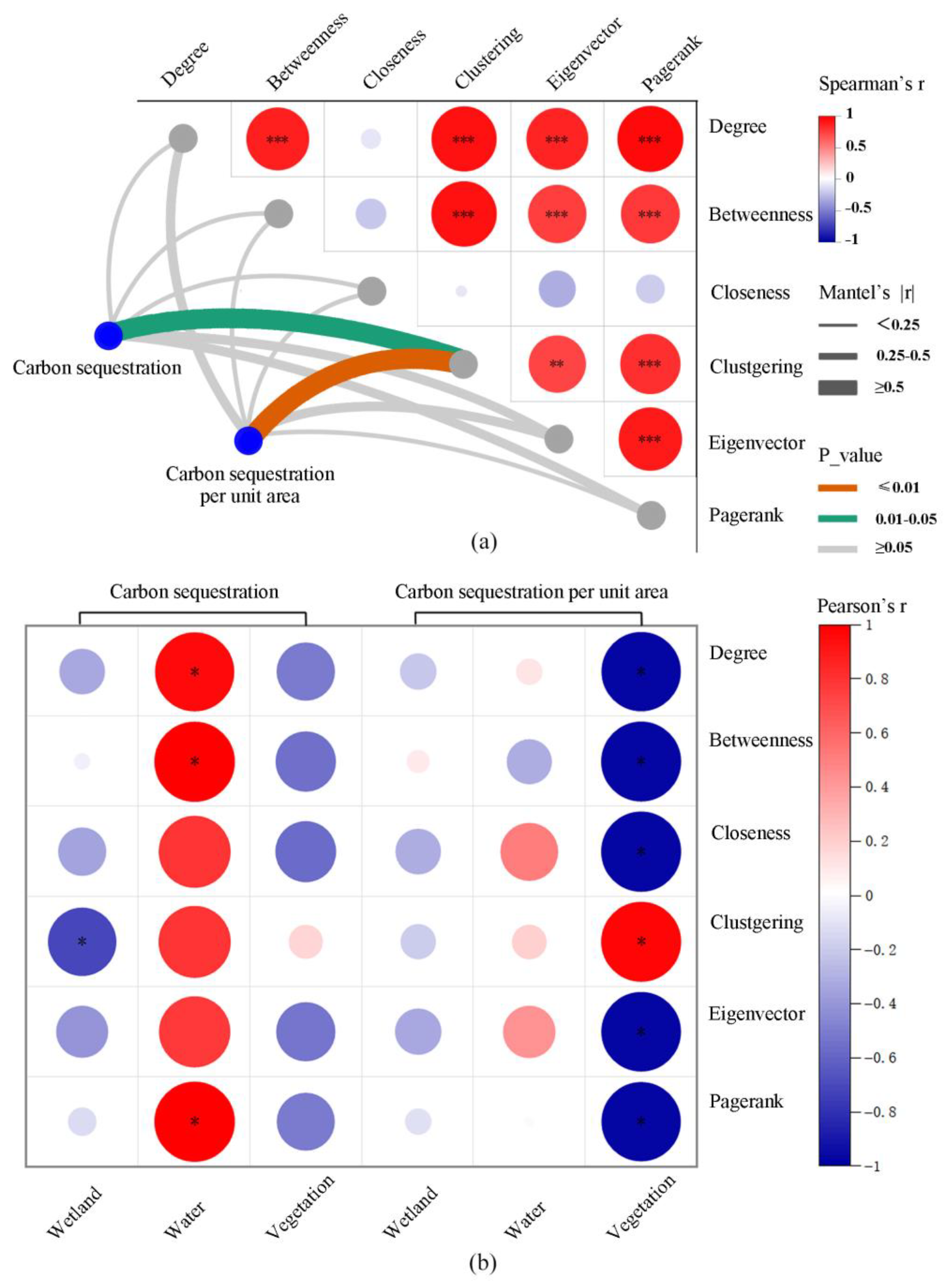
To further explore the relationship between the CSC of ecological sources and their relative position in the ecological network, the correlation between the CSC of ecological sources and various topological indicators of complex networks (Figure 7a) was analyzed. The correlation of carbon sequestration value and carbon sequestration value per unit area with clustering coefficient is significant (r = 0.507, p < 0.05) and highly significant (r = 0.725, p < 0.01), respectively. Based on the further correlation analysis of various ecological sources, it is found that the carbon sequestration and clustering coefficient of wetland sources are negatively correlated. The carbon sequestration value of water ecological sources is positively correlated with degree, betweenness centrality, and PageRank. The carbon sequestration value per unit area of vegetation ecological sources is positively correlated with the clustering coefficient and negatively correlated with the other five indicators (Figure 7b). Therefore, different optimization measures need to be emphasized for the improvement of CSC of various ecological sources. The increase in CSA requires the addition of other types of nodes to reduce the clustering coefficient of wetland nodes. Furthermore, for vegetation nodes, it is necessary to increase the node number of the same type to improve the clustering coefficient and reduce other topological indicators. However, the node number of all types needs to be reduced to improve all topological indicators of water nodes. There is a trade-off here in choosing to add water or vegetation nodes. And considering the overall situation, we have to consider abandoning water nodes.

5. Discussions

5.1. Spatial Distribution of Ecological Network

The ecological pattern of Yancheng City has the characteristics of typical coastal cities. The wetland is the dominant land-use type in many ecological sources, and many ecological corridors are distributed along the tributaries of the watershed. Ecological sources and important corridors of ecological networks with high habitat quality were mainly distributed in the eastern coastal wetland of the city. This is consistent with previous research on the ecological network of coastal cities [59]. Unlike other cities, few vegetation sources have a negative influence on the development of the city [22]. Therefore, there is great potential for the improvement of ecological networks in central and western regions. Ecological nodes and corridors need to be increased to improve the stability of ecological networks and the quality of urban ecology.
More importantly, the topological indicators of ecological nodes were found to have a significant positive correlation with CSC (Figure 7). Fang et al. [30] also proposed a similar conclusion that the CSC of vegetation nodes is related to its topological characteristics. In addition, the second law of geography was used to explain the reasons. Spatial heterogeneity caused by geographical space separation resulted in the difference in topological indicators of different types of ecological nodes.

5.2. Optimization and Improvement of Ecological Network

5.2.1. Identification of Stepping Stones

The identification of optimizable nodes in the ecological network is particularly important for maintaining the stability and scientific integrity of the entire ecological network [29]. The correlation analysis in Section 4.3.2 provides a new perspective for optimizing ecological nodes and CSC.
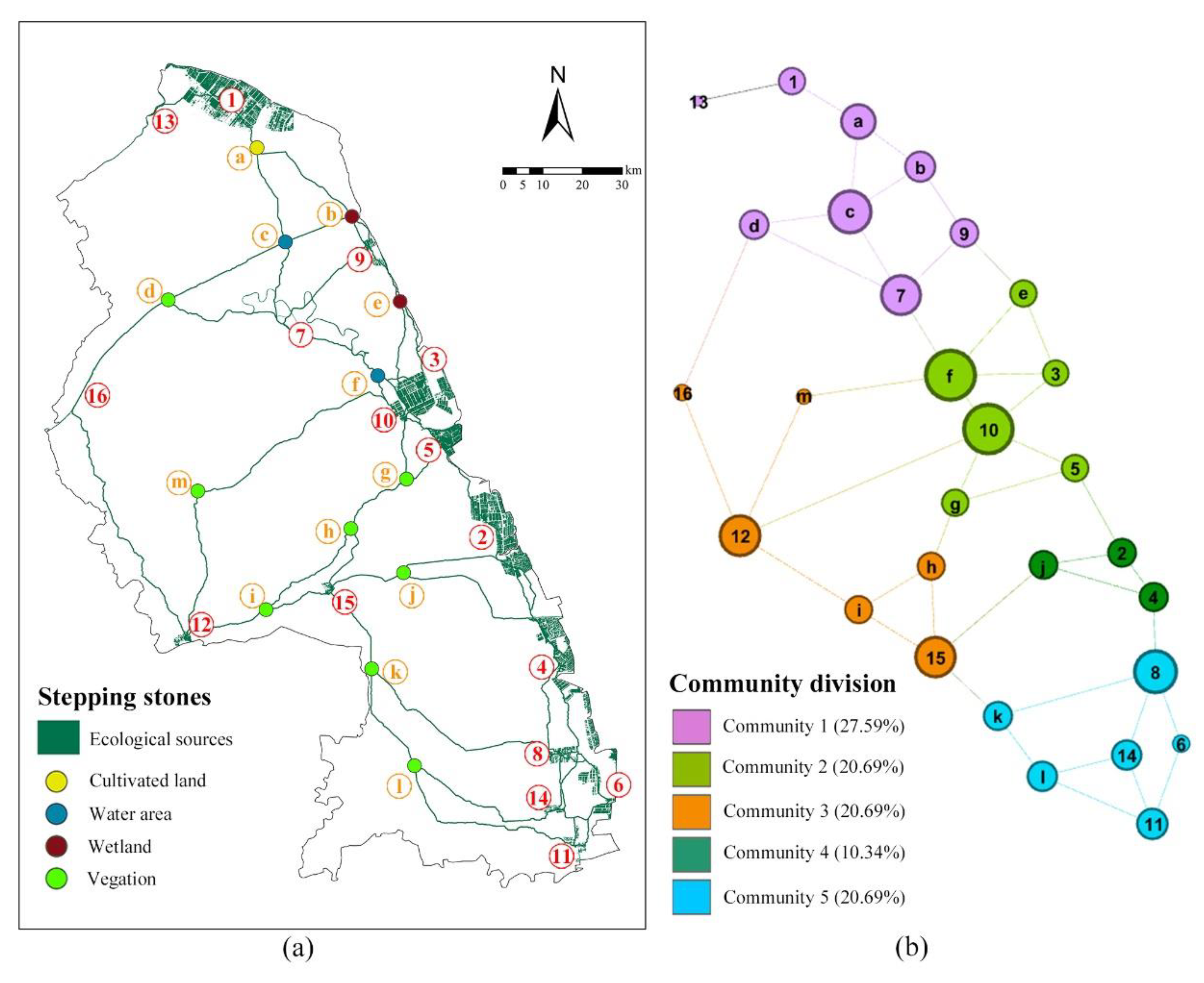
As shown in Figure 8a, stepping stones can provide transient habitat for species migration, contributing to the success of species migration and the survival of organisms. Therefore, the intersection points between ecological corridors are usually chosen as stepping stones. In addition, if the ecological corridor is too long, it will also increase the risk in the process of animal migration. It is also necessary to improve the small green patch through the ecological corridor as a stepping stone to shorten the length of the ecological corridor (stepping stone m) [25]. In this study, 13 patches with better habitat conditions near the intersection of ecological corridors were selected as ecological stepping stones where node a is cultivated land, b and e are wetlands, c and f are water areas, and the rest are vegetation areas.
After adding stepping stones, the overall structure and community division of the optimized topological network has undergone tremendous changes (Figure 8b). The average degree decreases from 3.8757 to 3.103, the network diameter increases from 6 to 11, and the average clustering coefficient declines from 0.508 to 0.229, indicating that the increase and scattered distribution of ecological stepping stones weaken the importance of each node and the aggregation degree of network, and enhance the stability of the ecological network. The network community division is related to the spatial location of nodes to a certain extent, and nodes in the same community have stronger connectivity with each other. In a certain geographical range, however, ecological nodes with any damage in the region have stronger stability. Among new ecological stepping stones, PageRank values of nodes ac, and f are the highest, revealing that the above four nodes play significant roles in optimizing the network and are key zones for development and construction.

5.2.2. Optimization of Ecological Corridors

In previous literature, how to scientifically improve and increase the ecological corridor lacked references and standards. Qiu et al. proposed an optimization strategy of adding ecological corridors or adding ecological stepping stones to shorten the shortest path between nodes with weak ecological functions or low carbon sequestration [30]. In our study, correlation analysis in Section 4.3.2 may provide a new perspective. It is feasible to improve CSC by increasing the node number to improve the clustering coefficient (Figure 7a). The construction of wetland nodes needs to rely on special water and soil environment, so it is not feasible to increase wetland nodes in the middle and west of Yancheng City. Therefore, the improvement of ecological nodes in the central and western regions of the city mainly needs to be optimized by vegetation nodes.
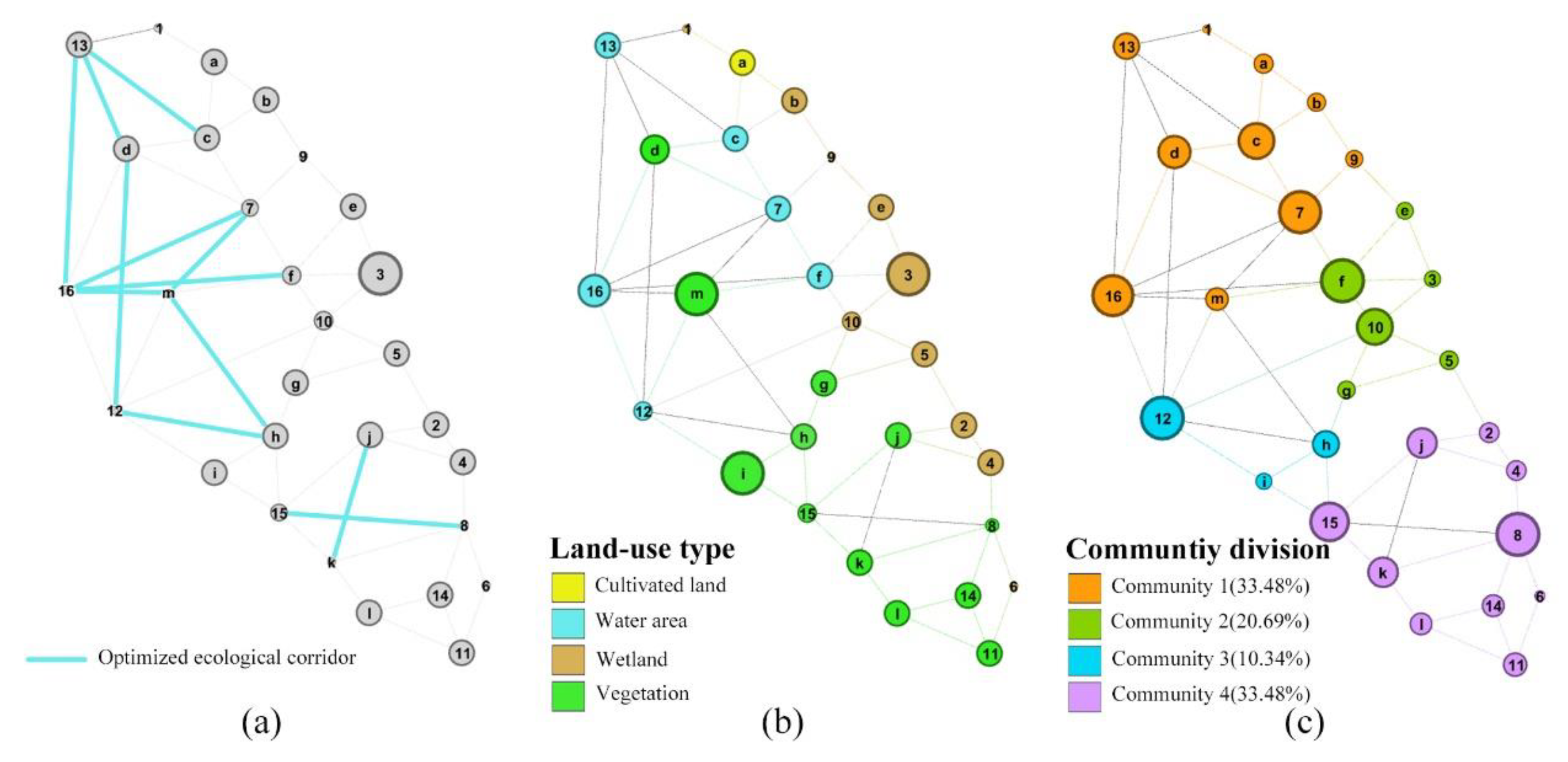
According to the significant positive correlation between the clustering coefficient and CSA per unit area of vegetation nodes (p < 0.05), enhancing the network connectivity is an effective means to improve the balance and stability of the ecological network. Therefore, topological nodes are sorted by clustering coefficient, and eco-sources (7, 8, 12, 13, 15, and 16) and eco-stepping stones (f, k, and m) with low values are selected (Figure 9a). Till then, 12 eco-corridors between selected nodes and their surrounding neighborhood are added, and the optimized ecological network is constructed (Figure 9b).
The average degree of optimized ecological network changes to 3.931, and the average clustering coefficient increases to 0.32. The number of network communities rises from 3 to 4 (Figure 9c), which is more suitable for the needs of urban form and ecological base. It is proved that the construction of ecological stepping stones has great optimization potential for ecological networks; clustering coefficients and PageRank values of optimized ecological networks are generally balanced; especially, vegetation nodes have been greatly improved (Figure 9b,c).

5.2.3. Enhancement of CSC

Enhancing the spatial landscape structure and improving the quality of urban ecology are considered effective ways to improve the sustainability of the urban ecosystem [60]. From a macroscopic perspective, by optimizing the ecological topological network, the material exchange capacity between ecological nodes can be promoted, the circulation risk can be reduced, and the CSC of urban ecosystems can be enhanced [25].
The CSA of different green ecosystems is different, and forests are the main body of terrestrial carbon sequestration all over the world [47]. In this study, it can be seen that coastal wetlands have the strongest CSC (Table 2) and fix 94% of total carbon sequestration among all types of ecological sources (Table 4). The coastal wetland system is an advantage of the ecological foundation of coastal cities. However, carbon sequestration of urban ecosystems cannot rely on wetlands alone. This result also shows the deficiencies of other green spaces in Yancheng City, as well as the huge potential for improvement. Therefore, this study proposes two strategies to improve the CSC of ecological networks. By increasing the vegetation ecological stepping stones, CSA will directly increase (Figure 8). In addition, the CSC of ecological nodes will be improved by increasing ecological corridors and clustering coefficient (Figure 9).
There is no doubt that the addition of ecological stepping stones and corridors will inevitably increase the carbon sequestration of the ecological network [61]. The larger the construction area of urban green space, the more the total carbon sequestration, and the larger the clustering coefficient between green spaces, the higher the carbon sequestration per unit area. The benefits of an improved ecological network and the increase in carbon sequestration are immeasurable [62].

5.2.4. Comparison and Analysis of Robustness

In this study, improving the stability and resilience of the ecosystem is another important purpose of optimizing the ecological network. Therefore, the robustness of the ecological network needs to be further verified [31].
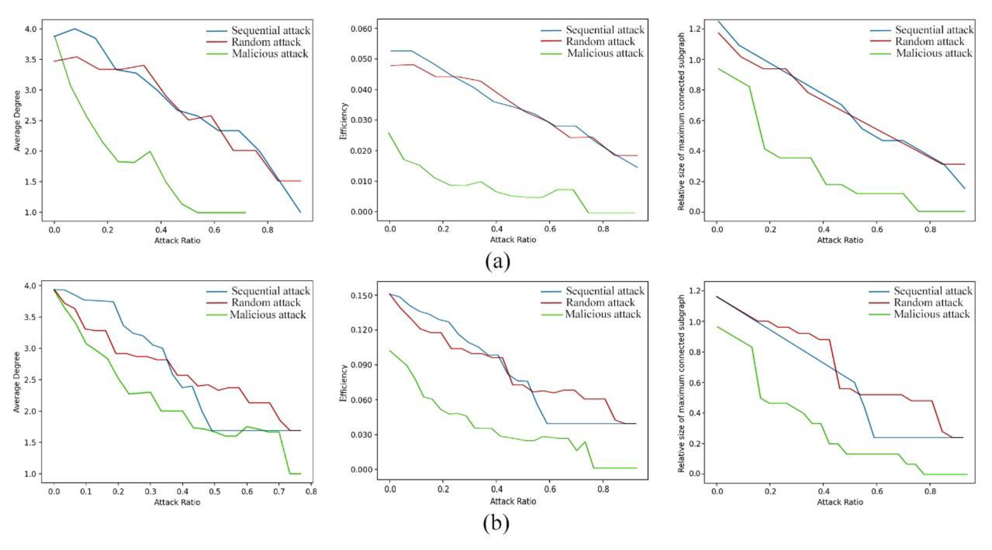
The resilience of ecological networks to shocks can be reflected by simulating the robustness of network matrices to sequential, random, and malicious attacks. On the platform of Phony 3, the ecological network is simulated as an undirected adjacency matrix [63]. The degree, efficiency, and relative size of the maximum connected subgraph for sequential, random, and malicious attacks were calculated, as shown in Figure 10. As the proportion of attacked nodes increases, the stability of the network decreases; as a whole, the stability of the optimized network is stronger than that of the unoptimized network. After network optimization, the degree and efficiency of the network have been reduced to a certain extent, indicating that the connectivity and stability of the network have been relatively improved, the importance of nodes has been reduced, and the connectivity distance has been shortened to a certain extent. Especially before the proportion of attacked nodes reaches 40%, the stability of the optimized network has significantly improved, indicating that the attack resistance of the network has also significantly improved (Figure 10b).

5.3. Applicability and Limitations

Under the background of achieving goals of carbon neutrality and peak carbon dioxide emissions in the world, all levels of cities in the world, especially coastal cities, need a research system that can coordinate and optimize the ecological function and CSC of urban ecosystems. This system can also improve the quantity and quality of ecological elements and optimize their spatial distribution, thereby forming a healthy and stable ecosystem structure on the macro scale of urban planning and construction and improving human ecological well-being [25]. The MSPA-MCR model used in this study is widely used and highly recognized in current ecological network construction [22]; choosing a carbon sequestration coefficient instead of NPP to estimate CSA is particularly suitable for cities with dense water networks of the same type [30]. Moreover, this paper also focuses on the strategies of ecological restoration and carbon sequestration improvement of coastal urban ecological networks. The research seeks universal ecological network optimization methods for cities under different ecological base conditions from the perspective of improving the CSC of ecological nodes, which is applicable to but not limited to coastal cities, and has certain reference significance for all levels of cities around the world.
In further study, the ecological support function of the study area to the surrounding area on a larger spatial scale should be considered. Some scholars have shown that different corridor widths directly affect ecosystem functions [64]. Combined with the migration path and corridor utilization needs of some protected species in Yancheng City, more targeted explorations on ecological corridor width and radiation channel must be carried out.

6. Conclusions

The establishment of an ecological network is an indispensable measure to realize regional sustainable development. In this study, Yancheng City’s ecological network was established. Topological indicators and CSC of each source region in the ecological network were calculated, and their correlation was also analyzed. According to the results of Spearman’s correlation coefficient analysis, the construction of ecological stepping stones and corridors has been added to guide urban habitat protection and carbon sequestration city construction. The main conclusions are as follows:
(1) The ecological pattern of Yancheng City has the characteristics of typical coastal cities, and the spatial distribution of Yancheng City’s ecological network is uneven. The ecological base in the central and western regions of the city is weak, which needs to be improved.
(2) There is a significant positive correlation between CSC and clustering efficiency. Improving the clustering efficiency of vegetation nodes is effective for strengthening the CSC of the ecological network in Yancheng City.
(3) Thirteen eco-stepping stones of four types (vegetation, wetland, water, and farmland) and 12 eco-corridors were added to improve the connectivity and balance of the network.
The purpose of this study is to enhance the CSC of the ecological network in Yancheng City and optimize the ecological network from the perspective of ecological function restoration and CSC improvement. This study has certain theoretical and practical significance for the studies of ecological network optimization and carbon sequestration function improvement in coastal cities around the world.

Supplementary Materials

The following supporting information can be downloaded at https://www.mdpi.com/article/10.3390/rs15164007/s1. Figure S1: Results of front resistance surfaces; Table S1: Definition and ecological implication of landscape types in MSPA; Table S2: Expert rating of resistance factors based on the AHP; Table S3: Comprehensive resistance evaluation index system; Table S4: Description of the topological indicators; Table S5: The description and calculation formulas of the robustness indicators; Table S6: Interaction matrix based on the gravity model.

Author Contributions

Conceptualization, N.Z. and C.Z.; methodology, C.Z.; software, N.Z. and J.A.; validation, C.Z.; formal analysis, N.Z., J.A., and Z.Z.; writing—original draft preparation, N.Z.; writing—review and editing, C.Z.; project administration, C.Z. All authors have read and agreed to the published version of the manuscript.

Funding

This research was funded by the Special Financial Grant of the Grand Canal Cultural Belt Construction Institute, grant number DYH22ZL08.

Data Availability Statement

Publicly available datasets were analyzed in this study. The data sources and access links are indicated in the text.

Acknowledgments

We thank Tao Liu and Zhengwang Li from Yangzhou University for their helpful criticism and linguistic assistance during the preparation of this manuscript. And we thank the dear editors and anonymous reviewers.

Conflicts of Interest

The authors declare no conflict of interest.

References

  1. Drius, M.; Carranza, M.L.; Stanisci, A.; Jones, L. The role of Italian coastal dunes as carbon sinks and diversity sources. A multi-service perspective. Appl. Geogr. 2016, 75, 127–136. [Google Scholar] [CrossRef] [Green Version]
  2. Zhang, X.; Liu, G.; Zheng, Z. Construction of an ecological security pattern based on functional wetland theory: A case study in a landscape city. Front. Environ. Sci. 2022, 10, 955230. [Google Scholar] [CrossRef]
  3. Xu, C.Y.; Pu, L.J.; Zhu, M.; Li, J.G.; Chen, X.J.; Wang, X.H.; Xie, X.F. Ecological security and ecosystem services in response to land use change in the coastal area of Jiangsu, China. Sustainability 2016, 8, 816. [Google Scholar] [CrossRef] [Green Version]
  4. Li, Z.T.; Li, M.; Xia, B.C. Spatio-temporal dynamics of ecological security pattern of the Pearl River Delta urban agglomeration based on LUCC simulation. Ecol. Indic. 2020, 114, 106319. [Google Scholar] [CrossRef]
  5. Yan, Y.; Ju, H.; Zhang, S.; Chen, G. The construction of ecological security patterns in coastal areas based on landscape ecological risk assessment—A case study of Jiaodong peninsula, China. Int. J. Environ. Res. Public Health 2021, 18, 12249. [Google Scholar] [CrossRef] [PubMed]
  6. Zhang, Z.; Li, H.; Shen, W.; Du, X.; Li, S.; Wei, Z.; Zhang, Z.J.; Feng, K.; Deng, Y. The large-scale spatial patterns of ecological networks between phytoplankton and zooplankton in coastal marine ecosystems. Sci. Total Environ. 2022, 827, 154285. [Google Scholar] [CrossRef]
  7. Li, F.; Ye, Y.; Song, B.; Wang, R. Evaluation of urban suitable ecological land based on the minimum cumulative resistance model: A case study from Changzhou, China. Ecol. Model. 2015, 318, 194–203. [Google Scholar] [CrossRef]
  8. Yao, L.; Li, X.; Li, Q.; Wang, J. Temporal and spatial changes in coupling and coordinating degree of new urbanization and ecological-environmental stress in China. Sustainability 2019, 11, 1171. [Google Scholar] [CrossRef] [Green Version]
  9. Linehan, J.; Gross, M.; Finn, J. Greenway planning: Developing a landscape ecological network approach. Landsc. Urban Plan. 1995, 33, 179–193. [Google Scholar] [CrossRef]
  10. An, Y.; Liu, S.; Sun, Y.; Shi, F.; Beazley, R. Construction and optimization of an ecological network based on morphological spatial pattern analysis and circuit theory. Landsc. Ecol. 2020, 36, 2059–2076. [Google Scholar] [CrossRef]
  11. De Montis, A.; Ganciu, A.; Cabras, M.; Bardi, A.; Peddio, V.; Caschili, S.; Massa, P.; Cocco, C.; Mulas, M. Resilient ecological networks: A comparative approach. Land Use Policy 2019, 89, 104207. [Google Scholar] [CrossRef]
  12. Jongman, R.; Külvik, M.; Kristiansen, I. European ecological networks and greenways. Landsc. Urban Plan. 2004, 68, 305–319. [Google Scholar] [CrossRef]
  13. Zhang, R.; Zhang, L.; Zhong, Q.; Zhang, Q.; Ji, Y.; Song, P.; Wang, Q. An optimized evaluation method of an urban ecological network: The case of the Minhang District of Shanghai. Urban For. Urban Green. 2021, 62, 127158. [Google Scholar] [CrossRef]
  14. Yang, C.; Guo, H.; Huang, X.; Wang, Y.; Li, X.; Cui, X. Ecological network construction of a bational park based on MSPA and MCR models: An example of the proposed national parks of “Ailaoshan-Wuliangshan” in China. Land 2022, 11, 1913. [Google Scholar] [CrossRef]
  15. Ren, J.; Yang, J.; Wu, F.; Sun, W.; Xiao, X.; Xia, J.C. Regional thermal environment changes: Integration of satellite data and land use/land cover. iScience 2023, 26, 105820. [Google Scholar] [CrossRef] [PubMed]
  16. Luo, X.; Yang, J.; Sun, W.; He, B. Suitability of human settlements in mountainous areas from the perspective of ventilation: A case study of the main urban area of Chongqing. J. Clean. Prod. 2021, 310, 127467. [Google Scholar] [CrossRef]
  17. Yu, Q.; Yue, D.; Wang, Y.; Kai, S.; Fang, M.; Ma, H.; Zhang, Q.; Huang, Y. Optimization of ecological node layout and stability analysis of ecological network in desert oasis: A typical case study of ecological fragile zone located at Deng Kou County (Inner Mongolia). Ecol. Indic. 2018, 84, 304–318. [Google Scholar] [CrossRef]
  18. Hepcan, S.; Hepcan, C.C.; Bouwma, I.M.; Jongman, R.H.G.; Özkan, M.B. Ecological networks as a new approach for nature conservation in Turkey: A case study of İzmir Province. Landsc. Urban Plan. 2009, 90, 143–154. [Google Scholar] [CrossRef]
  19. Nor, A.N.M.; Corstanje, R.; Harris, J.A.; Grafius, D.R.; Siriwardena, G.M. Ecological connectivity networks in rapidly expanding cities. Heliyon 2017, 3, e00325. [Google Scholar] [CrossRef] [Green Version]
  20. Xu, W.; Wang, J.; Zhang, M.; Li, S. Construction of landscape ecological network based on landscape ecological risk assessment in a large-scale opencast coal mine area. J. Clean. Prod. 2021, 286, 125523. [Google Scholar] [CrossRef]
  21. Costa, L.D.F.; Rodrigues, F.A.; Travieso, G.; Boas, P.R.V. Characterization of complex networks: A survey of measurements. Adv. Phys. 2007, 56, 167–242. [Google Scholar] [CrossRef] [Green Version]
  22. Hu, C.; Wang, Z.; Wang, Y.; Sun, D.; Zhang, J. Combining MSPA-MCR model to evaluate the ecological network in Wuhan, China. Land 2022, 11, 213. [Google Scholar] [CrossRef]
  23. Zhou, S.; Song, Y.; Li, Y.; Wang, J.; Zhang, L. Construction of ecological security pattern for plateau lake based on MSPA–MCR model: A case study of Dianchi lake area. Sustainability 2022, 14, 14532. [Google Scholar] [CrossRef]
  24. Li, S.; He, W.; Wang, L.; Zhang, Z.; Chen, X.; Lei, T.; Wang, S.; Wang, Z. Optimization of landscape pattern in China Luojiang Xiaoxi basin based on landscape ecological risk assessment. Ecol. Indic. 2023, 146, 109887. [Google Scholar] [CrossRef]
  25. Qiu, S.; Fang, M.; Yu, Q.; Niu, T.; Liu, H.; Wang, F.; Xu, C.; Ai, M.; Zhang, J. Study of spatialtemporal changes in Chinese forest eco-space and optimization strategies for enhancing carbon sequestration capacity through ecological spatial network theory. Sci. Total Environ. 2023, 859, 160035. [Google Scholar] [CrossRef] [PubMed]
  26. Zhang, P.; He, J.; Hong, X.; Zhang, W.; Qin, C.; Pang, B.; Li, Y.; Liu, Y. Carbon sources/sinks analysis of land use changes in China based on data envelopment analysis. J. Clean. Prod. 2018, 204, 702–711. [Google Scholar] [CrossRef]
  27. Watt, M.S.; Palmer, D.J.; Dungey, H.; Kimberley, M.O. Predicting the spatial distribution of Cupressus lusitanica productivity in New Zealand. For. Ecol. Manag. 2009, 258, 217–223. [Google Scholar] [CrossRef]
  28. Yang, Y.; Liu, Y.; Zhou, M.; Li, F.; Sun, C. Robustness assessment of urban rail transit based on complex network theory: A Case study of the Beijing subway. Saf. Sci. 2015, 79, 149–162. [Google Scholar] [CrossRef]
  29. Fang, M.; Si, G.; Yu, Q.; Huang, H.; Huang, Y.; Liu, W.; Guo, H. Study on the relationship between topological characteristics of vegetation ecospatial network and carbon sequestration capacity in the Yellow River basin, China. Remote Sens. 2021, 13, 4926. [Google Scholar] [CrossRef]
  30. Qiu, S.; Yu, Q.; Niu, T.; Fang, M.; Guo, H.; Liu, H.; Li, S.; Zhang, J. Restoration and renewal of ecological spatial network in mining cities for the purpose of enhancing carbon Sinks: The case of Xuzhou, China. Ecol. Indic. 2022, 143, 109313. [Google Scholar] [CrossRef]
  31. Fang, J.; Yu, G.; Liu, L.; Hu, S.; Chapin, F.S. Climate change, human impacts, and carbon sequestration in China. Proc. Natl. Acad. Sci. USA 2018, 115, 4015–4020. [Google Scholar] [CrossRef] [Green Version]
  32. Wang, X.; Wang, R.; Yu, Q.; Liu, H.; Liu, W.; Ma, J.; Niu, T.; Yang, L. Study on the structural properties of an ecospatial network in inner Mongolia and its relationship with NPP. Appl. Sci. 2022, 12, 4872. [Google Scholar] [CrossRef]
  33. Han, S.; Zhang, H.B.; Liu, Y.Q.; Xu, Y.; Wang, J.; Jiang, C. Spatiotemporal change of landscape elasticity in Yancheng coastal wetland of China. Appl. Ecol. Environ. Res. 2022, 20, 4935–4949. [Google Scholar] [CrossRef]
  34. Tian, P.; Cao, L.; Li, J.; Pu, R.; Shi, X.; Wang, L.; Liu, R.; Xu, H.; Tong, C.; Zhou, Z.; et al. Landscape grain effect in Yancheng coastal wetland and its response to landscape changes. Int. J. Environ. Res. Public Health 2019, 16, 2225. [Google Scholar] [CrossRef] [Green Version]
  35. Tian, P.; Cao, L.; Li, J.; Pu, R.; Gong, H.; Li, C. Landscape characteristics and ecological risk assessment based on multi-scenario simulations: A case study of Yancheng coastal wetland, China. Sustainability 2020, 13, 149. [Google Scholar] [CrossRef]
  36. Soille, P.; Vogt, P. Morphological segmentation of binary patterns. Pattern Recognit. Lett. 2009, 30, 456–459. [Google Scholar] [CrossRef]
  37. Zhang, P.; Shi, X.; Sun, Y.; Cui, J.; Shao, S. Have China’s provinces achieved their targets of energy intensity reduction? Reassessment based on nighttime lighting data. Energy Policy 2019, 128, 276–283. [Google Scholar] [CrossRef]
  38. Wickham, J.D.; Riitters, K.H.; Wade, T.G.; Vogt, P. A national assessment of green infrastructure and change for the conterminous United States using morphological image processing. Landsc. Urban Plan. 2010, 94, 186–195. [Google Scholar] [CrossRef]
  39. Pascual-Hortal, L.; Saura, S. Comparison and development of new graph-based landscape connectivity indices: Towards the priorization of habitat patches and corridors for conservation. Landsc. Ecol. 2006, 21, 959–967. [Google Scholar] [CrossRef]
  40. Saura, S.; Pascual-Hortal, L. A new habitat availability index to integrate connectivity in landscape conservation planning: Comparison with existing indices and application to a case study. Landsc. Urban Plan. 2007, 83, 91–103. [Google Scholar] [CrossRef]
  41. Knaapen, J.P.; Scheffer, M.; Harms, B. Estimating habitat isolation in landscape planning. Landsc. Urban Plan. 1992, 23, 1–16. [Google Scholar] [CrossRef]
  42. Li, Y.Y.; Zhang, Y.Z.; Jiang, Z.Y.; Guo, C.X.; Zhao, M.Y.; Yang, Z.G.; Guo, M.Y.; Wu, B.Y.; Chen, Q.L. Integrating morphological spatial pattern analysis and the minimal cumulative resistance model to optimize urban ecological networks: A case study in Shenzhen City, China. Ecol. Process. 2021, 10, 63. [Google Scholar] [CrossRef]
  43. Guan, H.; Bai, Y.; Zhang, C. Research on ecosystem security and restoration pattern of urban agglomeration in the Yellow River basin. Sustainability 2022, 14, 11599. [Google Scholar] [CrossRef]
  44. Peng, J.; Pan, Y.J.; Liu, Y.X.; Zhao, H.J.; Wang, Y.L. Linking ecological degradation risk to identify ecological security patterns in a rapidly urbanizing landscape. Habitat Int. 2018, 71, 110–124. [Google Scholar] [CrossRef]
  45. Su, K.; Yu, Q.; Yue, D.; Zhang, Q.; Yang, L.; Liu, Z.; Niu, T.; Sun, X. Simulation of a forest-grass ecological network in a typical desert oasis based on multiple scenes. Ecol. Model. 2019, 413, 108834. [Google Scholar] [CrossRef]
  46. Albert, R.; Barabasi, A.L. Statistical mechanics of complex networks. Rev. Mod. Phys. 2002, 74, 47–97. [Google Scholar] [CrossRef] [Green Version]
  47. Yu, G.R.; Chen, Z.; Piao, S.L.; Peng, C.H.; Ciais, P.; Wang, Q.F.; Li, X.R.; Zhu, X.J. High carbon dioxide uptake by subtropical forest ecosystems in the East Asian monsoon region. Proc. Natl. Acad. Sci. USA 2014, 111, 4910–4915. [Google Scholar] [CrossRef] [PubMed]
  48. Pan, Y.D.; Birdsey, R.A.; Fang, J.; Houghton, R.; Kauppi, P.E.; Kurz, W.A.; Phillips, O.L.; Shvidenko, A.; Lewis, S.L.; Canadell, J.G.; et al. A large and persistent carbon sink in the world’ s forests. Science 2011, 333, 988–993. [Google Scholar] [CrossRef] [PubMed] [Green Version]
  49. Zhu, J.X.; Hu, H.F.; Tao, S.L.; Chi, X.L.; Li, P.; Jiang, L.; Ji, C.J.; Zhu, J.L.; Tang, Z.Y.; Pan, Y.D.; et al. Carbon stocks and changes of dead organic matter in China’ s forests. Nat. Commun. 2017, 8, 151. [Google Scholar] [CrossRef] [Green Version]
  50. Zhang, H.F.; Chen, B.Z.; van der Laan-Luijk, I.T.; Machida, T.; Matsueda, H.; Sawa, Y.; Fukuyama, Y.; Langenfelds, R.; van der Schoot, M.; Xu, G.; et al. Estimating Asian terrestrial carbon fluxes from CONTRAIL aircraft and surface CO2 observations for the period 2006–2010. Atmos. Chem. Phys. 2014, 14, 5807–5824. [Google Scholar] [CrossRef] [Green Version]
  51. Batjes, N.H. Technologically achievable soil organic carbon sequestration in world croplands and grasslands. Land Degrad. Dev. 2019, 30, 25–32. [Google Scholar] [CrossRef] [Green Version]
  52. Ni, J. Carbon storage in terrestrial ecosystems of China: Estimates at different spatial resolutions and their responses to climate change. Clim. Chang. 2001, 49, 339–358. [Google Scholar] [CrossRef]
  53. Ni, J. Carbon storage in grasslands of China. J. Arid. Environ. 2002, 50, 205–218. [Google Scholar] [CrossRef]
  54. Xiao, D.R.; Deng, L.; Kim, D.G.; Huang, C.B.; Tian, K. Carbon budgets of wetland ecosystems in China. Glob. Chang. Biol. 2019, 25, 2061–2076. [Google Scholar] [CrossRef]
  55. Lu, W.Z.; Xiao, J.F.; Liu, F.; Zhang, Y.; Liu, C.A.; Lin, G.H. Contrasting ecosystem CO2 fluxes of inland and coastal wetlands: A meta-analysis of eddy covariance data. Glob. Chang. Biol. 2017, 23, 1180–1198. [Google Scholar] [CrossRef]
  56. Biederman, J.A.; Scott, R.L.; Arnone, J.A.; Jasoni, R.L.; Litvak, M.E.; Moreo, M.T.; Papuga, S.A.; Ponce-Campos, G.E.; Schreiner-McGraw, A.P.; Vivoni, E.R. Shrubland carbon sink depends upon winter water availability in the warm deserts of North America. Agric. For. Meteorol. 2018, 249, 407–419. [Google Scholar] [CrossRef]
  57. Cole, J.J.; Prairie, Y.T.; Caraco, N.F.; McDowell, W.H.; Tranvik, L.J.; Striegl, R.G.; Duarte, C.M.; Kortelainen, P.; Downing, J.A.; Middelburg, J.J.; et al. Plumbing the global carbon cycle: Integrating inland waters into the terrestrial carbon budget. Ecosystems 2007, 10, 172–185. [Google Scholar] [CrossRef] [Green Version]
  58. Song, S.; Xu, D.; Hu, S.; Shi, M. Ecological network optimization in urban central district based on complex network theory: A case study with the urban central district of Harbin. Int. J. Environ. Res. Public Health 2021, 18, 1427. [Google Scholar] [CrossRef]
  59. Zhang, J.; Cao, Y.; Ding, F.; Wu, J.; Chang, I.S. Regional ecological security pattern construction based on ecological barriers: A case study of the Bohai bay terrestrial ecosystem. Sustainability 2022, 14, 5384. [Google Scholar] [CrossRef]
  60. Qiao, Z.; Lu, Y.; He, T.; Wu, F.; Xu, X.; Liu, L.; Wang, F.; Sun, Z.; Han, D. Spatial expansion paths of urban heat islands in chinese cities: Analysis from a dynamic topological perspective for the improvement of climate resilience. Resour. Conserv. Recycl. 2023, 188, 106680. [Google Scholar] [CrossRef]
  61. Barot, S.; Yé, L.; Abbadie, L.; Blouin, M.; Frascaria-Lacoste, N. Ecosystem services must tackle anthropized ecosystems and ecological engineering. Ecol. Eng. 2017, 99, 486–495. [Google Scholar] [CrossRef]
  62. Yang, L.; Niu, T.; Yu, Q.; Zhang, X.; Wu, H. Relationship between topological structure and ecosystem services of forest grass ecospatial network in China. Remote Sens. 2022, 14, 4700. [Google Scholar] [CrossRef]
  63. Podobnik, B.; Lipic, T.; Horvatic, D.; Majdandzic, A.; Bishop, S.R.; Stanley, H.E. Predicting the lifetime of dynamic networks experiencing persistent random attacks. Sci. Rep. 2015, 5, 14286. [Google Scholar] [CrossRef] [PubMed] [Green Version]
  64. Liu, Y.; Ding, M. Maintenance and optimization of ecological space in natural resource-Advantaged cities: A case study in Zhangzhou, Fujian Province. Sustainability 2022, 14, 11952. [Google Scholar] [CrossRef]
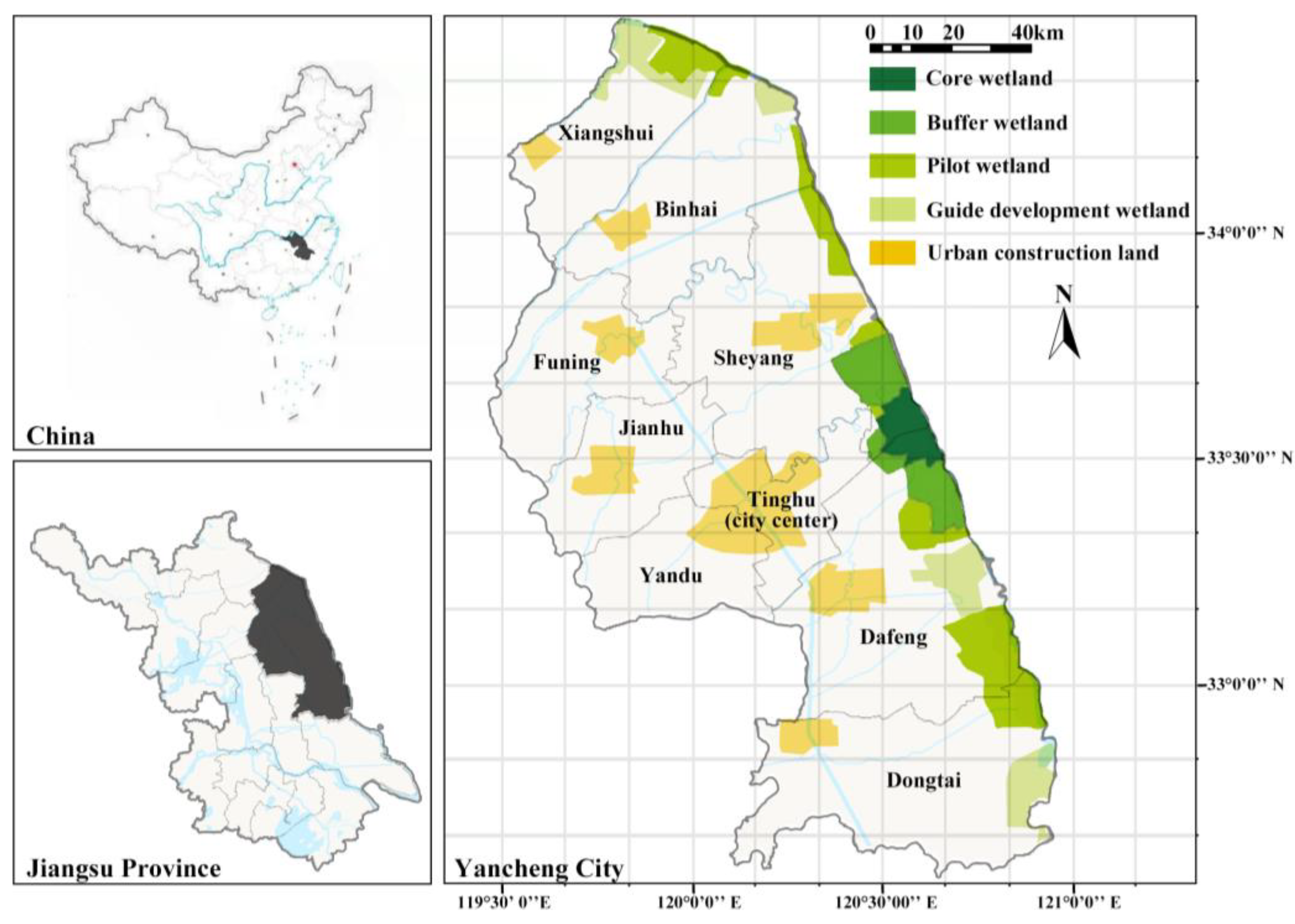
Figure 1. Location and urban protection zoning of the study area. The subgraph at the upper-left shows the map of China’s administrative divisions and the geographical location of Jiangsu Province. The lower-left corner shows the administrative map of Jiangsu Province and the geographical location of Yancheng City. And the right figure shows the coastal wetland protection zonings and urban construction land.
Remotesensing 15 04007 g001
Figure 2. The framework of this study.
Remotesensing 15 04007 g002
Figure 3. (a) Classification diagram of MSPA. (b) Distribution of ecological sources in Yancheng City. Numbers from 1 to 16 mark the locations of the ecological sources.
Remotesensing 15 04007 g003
Figure 4. Cumulative resistance surface.
Remotesensing 15 04007 g004
Figure 5. Potential ecological corridors of the study area. Numbers from 1 to 16 mark the ecological sources.
Remotesensing 15 04007 g005
Figure 6. (a) The topological network of ecological network. The node size represents the degree index. (b) The modular division of ecological network. The node size represents the modularity index. (c) The results of six topological indicators of ecological sources. The background color represents the grouping of three modules. Numbers from 1 to 16 mark the ecological sources.
Remotesensing 15 04007 g006
Figure 7. (a) Pairwise comparisons of topological indicators shown with a color gradient representing Spearman’s correlation coefficients. Mantel tests depict the association of carbon storage indicators of ecological sources with topological indicators. The width of each edge matches Mantel’s r statistic for the equivalent distance correlations. (b) Pearson’s correlation coefficients matrix between the topological indicators and carbon sequestration indicators of the three kinds of ecological sources. Asterisks denote the significance level: * 0.01 < p < 0.05, ** 0.001 < p < 0.01, *** p < 0.001.
Remotesensing 15 04007 g007
Figure 8. (a) Identification of stepping stones in the study area. (b) The modular division of the optimized ecological nodes. The node size represents the PageRank. Numbers from 1 to 16 mark the ecological sources, and letters a to m mark the stepping stones.
Remotesensing 15 04007 g008
Figure 9. (a) Identification of the optimized ecological corridors. The node size represents the clustering coefficient. (b) The land-use division of the optimized ecological network. The node size represents the clustering coefficient. (c) The modular division of the optimized ecological network. The node size represents the PageRank. Numbers from 1 to 16 mark the ecological sources, and letters a to m mark the stepping stones.
Remotesensing 15 04007 g009
Figure 10. Variation of the robustness of un-optimized (a) and optimized (b) ecological network.
Remotesensing 15 04007 g010
Table 1. The list of data used in this study.
CategoryIndicatorsSources (accessed on 10 March 2022)
SocioeconomicBoundary zoning dataThe Resource and Environment Science and Data Center of the Chinese Academy of Sciences (https://www.resdc.cn/)
Population density dataWorldPop (https://www.worldpop.org/)
Land use and land cover (LULC) dataThe Geographic Information Monitoring Cloud Global Land Cover (http://data.ess.tsinghua.edu.cn/)
Road network dataOpenStreetMap (https://www.openstreetmap.org/)
NPP and CO2 concentration dataGeographic Remote Sensing Ecological Network Platform (https://www.gisrs.cn)
GeospatialDEM and slope dataASF Data Search (https://search.asf.alaska.edu/)
Water network dataOpenStreetMap (https://www.openstreetmap.org/)
Mean annual precipitation dataGeographic Remote Sensing Ecological Network Platform (https://www.gisrs.cn)
NDVI dataUSGS (https://www.usgs.gov/)
Table 3. Classification statistics of MSPA.
Landscape TypeArea (km2)Accounting for Area of Foreground (%)Accounting for Area of Study Area (%)
Core781.4648.405.04
Bridge132.428.200.85
Loop66.194.100.43
Branch91.305.650.59
Islet237.2014.691.53
Edge306.0618.961.97
Perforation28.791.780.19
Total1614.63100.0010.41
Table 4. Carbon sequestration estimation of each type of ecological source.
No. of Eco-SourcesDominant Land-Use Type Area
(ha)
Accounting for Area of Total Eco-Sources (%)CSA
(Mg C)
Accounting for Total CSA (%)CSA Per Unit Area
(Mg C ha−1)
1–6, 9, 10Wetland45,65088.6216,387,87994.19358.99
7, 12, 13, 16Water30745.972,734,7801.5788.96
8, 11, 14, 15Vegetation27855.41738,0284.24264.96
Total 51,50910017,399,385100337.79
CSA: Carbon sequestration amount.
Disclaimer/Publisher’s Note: The statements, opinions and data contained in all publications are solely those of the individual author(s) and contributor(s) and not of MDPI and/or the editor(s). MDPI and/or the editor(s) disclaim responsibility for any injury to people or property resulting from any ideas, methods, instructions or products referred to in the content.