Terrestrial and Airborne Lidar to Quantify Shrub Cover for Canada Lynx (Lynx canadensis) Habitat Using Machine Learning
Abstract
:1. Introduction
1.1. Canada Lynx
1.2. Habitat-Sampling Methods
1.3. Lidar
1.4. Objectives
- To generate a range of metrics that quantify understory horizontal cover from single-point TLS scans, and to determine which of these horizontal cover metrics best differentiates low from high horizontal cover.
- To use TLS-derived understory horizontal cover metrics to train a model predicting horizontal cover from a host of ALS metrics at plot scale, which can then be applied to the rasterized ALS metrics to map horizontal cover across the landscape.
2. Methods
2.1. Study Area
2.2. Site Selection
2.3. TLS Acquisition
2.4. TLS Pre-Processing and Georectification
2.5. TLS Digital Cover Board (DCB)
2.6. TLS Voxelization
2.7. ALS Data
2.8. Statistical Analysis
3. Results
3.1. TLS PCA
3.2. Models
3.2.1. Regression
3.2.2. Machine Learning
3.2.3. Model Output
4. Discussion
4.1. TLS Metrics
4.2. ALS Metrics
4.3. Model Fit
5. Conclusions
Author Contributions
Funding
Data Availability Statement
Acknowledgments
Conflicts of Interest
References
- US Fish Wildlife Service. Species Status Assessment for the Canada Lynx (Lynx canadensis) Contiguous United States Distinct Population Segment; Version 10; US Fish Wildlife Service: Lakewood, CA, USA, 2017.
- Elton, C.; Nicholson, M. The Ten-Year Cycle in Numbers of the Lynx in Canada. J. Anim. Ecol. 1942, 11, 215–244. [Google Scholar] [CrossRef]
- Koehler, G.M. Population and Habitat Characteristics of Lynx and Snowshoe Hares in North Central Washington. Can. J. Zool. 1990, 68, 845–851. [Google Scholar] [CrossRef]
- Koehler, G.M.; Gm, K.; Mg, H.; Hs, H. Lynx Movements and Habitat Use in Montana. Can. Field-Nat. 1979, 93, 441–442. [Google Scholar]
- Murray, D.L.; Boutin, S.; O’Donoghue, M. Winter Habitat Selection by Lynx and Coyotes in Relation to Snowshoe Hare Abundance. Can. J. Zool. 1994, 72, 1444–1451. [Google Scholar] [CrossRef]
- Parker, G.R.; Maxwell, J.W.; Morton, L.D.; Smith, G.E.J. The Ecology of the Lynx (Lynx canadensis) on Cape Breton Island. Can. J. Zool. 1983, 61, 770–786. [Google Scholar] [CrossRef]
- Poole, K.G. A Review of the Canada Lynx, Lynx canadensis, in Canada. Can. Field-Nat. 2003, 117, 360–376. [Google Scholar] [CrossRef]
- Poole, K.G. Characteristics of an Unharvested Lynx Population during a Snowshoe Hare Decline. J. Wildl. Manag. 1994, 58, 608–618. [Google Scholar] [CrossRef]
- Fuller, A.K.; Harrison, D.J. Movement Paths Reveal Scale-Dependent Habitat Decisions by Canada Lynx. J. Mammal. 2010, 91, 1269–1279. [Google Scholar] [CrossRef]
- Ivan, J.S.; Shenk, T.M. Winter Diet and Hunting Success of Canada Lynx in Colorado. J. Wildl. Manag. 2016, 80, 1049–1058. [Google Scholar] [CrossRef]
- Maletzke, B.T.; Koehler, G.M.; Wielgus, R.B.; Aubry, K.B.; Evans, M.A. Habitat Conditions Associated with Lynx Hunting Behavior during Winter in Northern Washington. J. Wildl. Manag. 2008, 72, 1473–1478. [Google Scholar] [CrossRef]
- Quade, C.; Minkova, T. 2006 Washington DNR Lynx Management Plan; Washington State Department of Natural Resources: Olympia, WA, USA, 2006.
- Collins, W.B.; Becker, E.F. Estimation of Horizontal Cover. J. Range Manag. 2001, 54, 67–70. [Google Scholar] [CrossRef]
- Campbell, M.J.; Dennison, P.E.; Hudak, A.T.; Parham, L.M.; Butler, B.W. Quantifying Understory Vegetation Density Using Small-Footprint Airborne Lidar. Remote Sens. Environ. 2018, 215, 330–342. [Google Scholar] [CrossRef]
- Jorgensen, C.F.; Stutzman, R.J.; Anderson, L.C.; Decker, S.E.; Powell, L.A.; Schacht, W.H.; Fontaine, J.J. Choosing a DIVA: A Comparison of Emerging Digital Imagery Vegetation Analysis Techniques. Appl. Veg. Sci. 2013, 16, 552–560. [Google Scholar] [CrossRef]
- Beland, M.; Parker, G.; Sparrow, B.; Harding, D.; Chasmer, L.; Phinn, S.; Antonarakis, A.; Strahler, A. On Promoting the Use of Lidar Systems in Forest Ecosystem Research. For. Ecol. Manag. 2019, 450, 117484. [Google Scholar] [CrossRef]
- Coops, N.C.; Tompalski, P.; Goodbody, T.R.; Queinnec, M.; Luther, J.E.; Bolton, D.K.; White, J.C.; Wulder, M.A.; van Lier, O.R.; Hermosilla, T. Modelling Lidar-Derived Estimates of Forest Attributes over Space and Time: A Review of Approaches and Future Trends. Remote Sens. Environ. 2021, 260, 112477. [Google Scholar] [CrossRef]
- Bouvier, M.; Durrieu, S.; Fournier, R.A.; Renaud, J.-P. Generalizing Predictive Models of Forest Inventory Attributes Using an Area-Based Approach with Airborne LiDAR Data. Remote Sens. Environ. 2015, 156, 322–334. [Google Scholar] [CrossRef]
- Hudak, A.T.; Strand, E.K.; Vierling, L.A.; Byrne, J.C.; Eitel, J.U.; Martinuzzi, S.; Falkowski, M.J. Quantifying Aboveground Forest Carbon Pools and Fluxes from Repeat LiDAR Surveys. Remote Sens. Environ. 2012, 123, 25–40. [Google Scholar] [CrossRef]
- Hudak, A.T.; Evans, J.S.; Stuart Smith, A.M. LiDAR Utility for Natural Resource Managers. Remote Sens. 2009, 1, 934–951. [Google Scholar] [CrossRef]
- Zhao, K.; Popescu, S.; Meng, X.; Pang, Y.; Agca, M. Characterizing Forest Canopy Structure with Lidar Composite Metrics and Machine Learning. Remote Sens. Environ. 2011, 115, 1978–1996. [Google Scholar] [CrossRef]
- Zheng, G.; Ma, L.; Eitel, J.U.H.; He, W.; Magney, T.S.; Moskal, L.M.; Li, M. Retrieving Directional Gap Fraction, Extinction Coefficient, and Effective Leaf Area Index by Incorporating Scan Angle Information From Discrete Aerial Lidar Data. IEEE Trans. Geosci. Remote Sens. 2017, 55, 577–590. [Google Scholar] [CrossRef]
- García-Gutiérrez, J.; Martínez-Álvarez, F.; Troncoso, A.; Riquelme, J.C. A Comparison of Machine Learning Regression Techniques for LiDAR-Derived Estimation of Forest Variables. Neurocomputing 2015, 167, 24–31. [Google Scholar] [CrossRef]
- Gleason, C.J.; Im, J. Forest Biomass Estimation from Airborne LiDAR Data Using Machine Learning Approaches. Remote Sens. Environ. 2012, 125, 80–91. [Google Scholar] [CrossRef]
- Weiss, U.; Biber, P.; Laible, S.; Bohlmann, K.; Zell, A. Plant Species Classification Using a 3D LIDAR Sensor and Machine Learning. In Proceedings of the 2010 Ninth International Conference on Machine Learning and Applications, Washington, DC, USA, 12–14 December 2010; pp. 339–345. [Google Scholar]
- Marrs, J.; Ni-Meister, W. Machine Learning Techniques for Tree Species Classification Using Co-Registered LiDAR and Hyperspectral Data. Remote Sens. 2019, 11, 819. [Google Scholar] [CrossRef]
- Lee, J.; Im, J.; Kim, K.; Quackenbush, L.J. Machine Learning Approaches for Estimating Forest Stand Height Using Plot-Based Observations and Airborne LiDAR Data. Forests 2018, 9, 268. [Google Scholar] [CrossRef]
- Farhani, G.; Sica, R.J.; Daley, M.J. Classification of Lidar Measurements Using Supervised and Unsupervised Machine Learning Methods. Atmos. Meas. Tech. 2021, 14, 391–402. [Google Scholar] [CrossRef]
- Teri, S.S.; Musliman, I.A. Machine Learning in Big Lidar Data: A Review. Int. Arch. Photogramm. Remote Sens. Spat. Inf. Sci. 2019, XLII-4-W16, 641–644. [Google Scholar] [CrossRef]
- Chen, T.; Guestrin, C. Xgboost: A Scalable Tree Boosting System. In Proceedings of the 22nd ACM Sigkdd International Conference on Knowledge Discovery and Data Mining, San Francisco, CA, USA, 13–17 August 2016; pp. 785–794. [Google Scholar]
- Liu, M.; Han, Z.; Chen, Y.; Liu, Z.; Han, Y. Tree Species Classification of LiDAR Data Based on 3D Deep Learning. Measurement 2021, 177, 109301. [Google Scholar] [CrossRef]
- Liu, H.; Shen, X.; Cao, L.; Yun, T.; Zhang, Z.; Fu, X.; Chen, X.; Liu, F. Deep Learning in Forest Structural Parameter Estimation Using Airborne Lidar Data. IEEE J. Sel. Top. Appl. Earth Obs. Remote Sens. 2020, 14, 1603–1618. [Google Scholar] [CrossRef]
- Marinelli, D.; Paris, C.; Bruzzone, L. An Approach Based on Deep Learning for Tree Species Classification in LiDAR Data Acquired in Mixed Forest. IEEE Geosci. Remote Sens. Lett. 2022, 19, 1–5. [Google Scholar] [CrossRef]
- Blomdahl, E.M.; Thompson, C.M.; Kane, J.R.; Kane, V.R.; Churchill, D.; Moskal, L.M.; Lutz, J.A. Forest Structure Predictive of Fisher (Pekania Pennanti) Dens Exists in Recently Burned Forest in Yosemite, California, USA. For. Ecol. Manag. 2019, 444, 174–186. [Google Scholar] [CrossRef]
- Johnston, A.N.; Moskal, L.M. High-Resolution Habitat Modeling with Airborne LiDAR for Red Tree Voles. J. Wildl. Manag. 2017, 81, 58–72. [Google Scholar] [CrossRef]
- North, M.P.; Kane, J.T.; Kane, V.R.; Asner, G.P.; Berigan, W.; Churchill, D.J.; Conway, S.; Gutiérrez, R.J.; Jeronimo, S.; Keane, J.; et al. Cover of Tall Trees Best Predicts California Spotted Owl Habitat. For. Ecol. Manag. 2017, 405, 166–178. [Google Scholar] [CrossRef]
- Tymen, B.; Vincent, G.; Courtois, E.A.; Heurtebize, J.; Dauzat, J.; Marechaux, I.; Chave, J. Quantifying Micro-Environmental Variation in Tropical Rainforest Understory at Landscape Scale by Combining Airborne LiDAR Scanning and a Sensor Network. Ann. For. Sci. 2017, 74, 32. [Google Scholar] [CrossRef]
- Venier, L.A.; Swystun, T.; Mazerolle, M.J.; Kreutzweiser, D.P.; Wainio-Keizer, K.L.; McIlwrick, K.A.; Woods, M.E.; Wang, X. Modelling Vegetation Understory Cover Using LiDAR Metrics. PLoS ONE 2019, 14, e0220096. [Google Scholar] [CrossRef]
- Wing, B.M.; Ritchie, M.W.; Boston, K.; Cohen, W.B.; Gitelman, A.; Olsen, M.J. Prediction of Understory Vegetation Cover with Airborne Lidar in an Interior Ponderosa Pine Forest. Remote Sens. Environ. 2012, 124, 730–741. [Google Scholar] [CrossRef]
- Fekety, P.A.; Sadak, R.B.; Sauder, J.D.; Hudak, A.T.; Falkowski, M.J. Predicting Forest Understory Habitat for Canada Lynx Using LIDAR Data. Wildl. Soc. Bull. 2019, 43, 619–629. [Google Scholar] [CrossRef]
- Olsoy, P.J.; Forbey, J.S.; Rachlow, J.L.; Nobler, J.D.; Glenn, N.F.; Shipley, L.A. Fearscapes: Mapping Functional Properties of Cover for Prey with Terrestrial LiDAR. BioScience 2015, 65, 74–80. [Google Scholar] [CrossRef]
- Huang, H.; Gong, P.; Cheng, X.; Clinton, N.; Cao, C.; Ni, W.; Li, Z.; Wang, L. Forest Structural Parameter Extraction Using Terrestrial LiDAR. In Proceedings of the SilviLaser 2009, Station, TX, USA, 14–16 October 2009. [Google Scholar]
- Ashcroft, M.B.; Gollan, J.R.; Ramp, D. Creating Vegetation Density Profiles for a Diverse Range of Ecological Habitats Using Terrestrial Laser Scanning. Methods Ecol. Evol. 2014, 5, 263–272. [Google Scholar] [CrossRef]
- Wallace, L.; Hally, B.; Hillman, S.; Jones, S.D.; Reinke, K. Terrestrial Image-Based Point Clouds for Mapping Near-Ground Vegetation Structure: Potential and Limitations. Fire 2020, 3, 59. [Google Scholar] [CrossRef]
- Batchelor, J.L.; Wilson, T.M.; Olsen, M.J.; Ripple, W.J. New Structural Complexity Metrics for Forests from Single Terrestrial Lidar Scans. Remote Sens. 2023, 15, 145. [Google Scholar] [CrossRef]
- Richardson, J.J.; Moskal, L.M.; Bakker, J.D. Terrestrial Laser Scanning for Vegetation Sampling. Sensors 2014, 14, 20304–20319. [Google Scholar] [CrossRef] [PubMed]
- Washington State Department of Natural Resources Loomis State Forest Landscape Plan. 1996. Available online: https://www.dnr.wa.gov/publications/lm_loomis_sec4.pdf (accessed on 25 August 2023).
- Gould, P.; Strunk, J.; Tenneson, K. Introducing the Remote Sensing Forest Inventory System (RS-FRIS); Version 1.0. Revision 1; Internal Document; Washington State Department of Natural Resources: Olympia, WA, USA, 2015.
- FARO Scene [Computer Software], Version 2019.2 (7.5.5.4303); FARO: Lake Mary, FL, USA, 2021. Available online: http://www.faro.com (accessed on 25 August 2023).
- CloudCompare [Computer Software], Version 2.11; 2019. Available online: http://www.cloudcompare.org (accessed on 1 March 2021).
- Roussel, J.-R.; Auty, D.; Coops, N.C.; Tompalski, P.; Goodbody, T.R.; Meador, A.S.; Bourdon, J.-F.; De Boissieu, F.; Achim, A. LidR: An R Package for Analysis of Airborne Laser Scanning (ALS) Data. Remote Sens. Environ. 2020, 251, 112061. [Google Scholar] [CrossRef]
- Roussel, J.-R.; Auty, D. lidR (version 3.1.2) R Package. 2021. Available online: https://github.com/r-lidar/lidR (accessed on 6 September 2023).
- Ross, C.W.; Loudermilk, E.L.; Skowronski, N.; Pokswinski, S.; Hiers, J.K.; O’Brien, J. LiDAR Voxel-Size Optimization for Canopy Gap Estimation. Remote Sens. 2022, 14, 1054. [Google Scholar] [CrossRef]
- Zong, X.; Wang, T.; Skidmore, A.K.; Heurich, M. The Impact of Voxel Size, Forest Type, and Understory Cover on Visibility Estimation in Forests Using Terrestrial Laser Scanning. GIScience Remote Sens. 2021, 58, 323–339. [Google Scholar] [CrossRef]
- Woods, M.; Lim, K.; Treitz, P. Predicting Forest Stand Variables from LiDAR Data in the Great Lakes—St. Lawrence Forest of Ontario. For. Chron. 2008, 84, 827–839. [Google Scholar] [CrossRef]
- Litvaitis, J.A.; Sherburne, J.A.; Bissonette, J.A. Influence of Understory Characteristics on Snowshoe Hare Habitat Use and Density. J. Wildl. Manag. 1985, 49, 866–873. [Google Scholar] [CrossRef]
- Vanbianchi, C.; Gaines, W.L.; Murphy, M.A.; Pither, J.; Hodges, K.E. Habitat Selection by Canada Lynx: Making Do in Heavily Fragmented Landscapes. Biodivers. Conserv. 2017, 26, 3343–3361. [Google Scholar] [CrossRef]
- Burgett, S.; Rachlow, J.; Stein, R. Unexpected Properties of Habitat Altered by Ecosystem Engineers: A Pygmy Rabbit Case Study. Available online: https://scholarworks.boisestate.edu/icur/2021/poster_session/12/ (accessed on 16 December 2022).
- Galluzzi, M.; Puletti, N.; Armanini, M.; Chirichella, R.; Mustoni, A. Mobile Laser Scanner Understory Characterization: An Exploratory Study on Hazel Grouse in Italian Alps. bioRxiv 2022. [Google Scholar] [CrossRef]
- Lecigne, B.; Eitel, J.; Rachlow, J. Viewshed3d: An R Package for Quantifying 3D Visibility Using Terrestrial Lidar Data. Methods Ecol. Evol. 2020, 11, 733–738. [Google Scholar] [CrossRef]
- Béland, M.; Baldocchi, D.D.; Widlowski, J.-L.; Fournier, R.A.; Verstraete, M.M. On Seeing the Wood from the Leaves and the Role of Voxel Size in Determining Leaf Area Distribution of Forests with Terrestrial LiDAR. Agric. For. Meteorol. 2014, 184, 82–97. [Google Scholar] [CrossRef]
- Soma, M.; Pimont, F.; Dupuy, J.-L. Sensitivity of Voxel-Based Estimations of Leaf Area Density with Terrestrial LiDAR to Vegetation Structure and Sampling Limitations: A Simulation Experiment. Remote Sens. Environ. 2021, 257, 112354. [Google Scholar] [CrossRef]
- Bauwens, S.; Bartholomeus, H.; Calders, K.; Lejeune, P. Forest Inventory with Terrestrial LiDAR: A Comparison of Static and Hand-Held Mobile Laser Scanning. Forests 2016, 7, 127. [Google Scholar] [CrossRef]
- Donager, J.J.; Sánchez Meador, A.J.; Blackburn, R.C. Adjudicating Perspectives on Forest Structure: How Do Airborne, Terrestrial, and Mobile Lidar-Derived Estimates Compare? Remote Sens. 2021, 13, 2297. [Google Scholar] [CrossRef]
- Gobakken, T.; Næsset, E. Weibull and Percentile Models for Lidar-Based Estimation of Basal Area Distribution. Scand. J. For. Res. 2005, 20, 490–502. [Google Scholar] [CrossRef]
- Qu, Y.; Shaker, A.; Silva, C.A.; Klauberg, C.; Pinagé, E.R. Remote Sensing of Leaf Area Index from LiDAR Height Percentile Metrics and Comparison with MODIS Product in a Selectively Logged Tropical Forest Area in Eastern Amazonia. Remote Sens. 2018, 10, 970. [Google Scholar] [CrossRef]
- Simonson, W.D.; Allen, H.D.; Coomes, D.A. Applications of Airborne Lidar for the Assessment of Animal Species Diversity. Methods Ecol. Evol. 2014, 5, 719–729. [Google Scholar] [CrossRef]
- Estornell, J.; Ruiz, L.A.; Velázquez-Martí, B.; Fernández-Sarría, A. Estimation of Shrub Biomass by Airborne LiDAR Data in Small Forest Stands. For. Ecol. Manag. 2011, 262, 1697–1703. [Google Scholar] [CrossRef]
- Giannico, V.; Lafortezza, R.; John, R.; Sanesi, G.; Pesola, L.; Chen, J. Estimating Stand Volume and Above-Ground Biomass of Urban Forests Using LiDAR. Remote Sens. 2016, 8, 339. [Google Scholar] [CrossRef]
- Kane, V.R.; McGaughey, R.J.; Bakker, J.D.; Gersonde, R.F.; Lutz, J.A.; Franklin, J.F. Comparisons between Field-and LiDAR-Based Measures of Stand Structural Complexity. Can. J. For. Res. 2010, 40, 761–773. [Google Scholar] [CrossRef]
- Fritzmann, P.; Höfle, B.; Vetter, M.; Sailer, R.; Stötter, J.; Bollmann, E. Surface Classification Based on Multi-Temporal Airborne LiDAR Intensity Data in High Mountain Environments, A Case Study from Hintereisferner, Austria. Z. Geomorphol. Suppl. Issues 2011, 55, 105–126. [Google Scholar] [CrossRef]
- Yan, W.Y.; Shaker, A.; Habib, A.; Kersting, A.P. Improving Classification Accuracy of Airborne LiDAR Intensity Data by Geometric Calibration and Radiometric Correction. ISPRS J. Photogramm. Remote Sens. 2012, 67, 35–44. [Google Scholar] [CrossRef]
- Kashani, A.G.; Olsen, M.J.; Parrish, C.E.; Wilson, N. A Review of LiDAR Radiometric Processing: From Ad Hoc Intensity Correction to Rigorous Radiometric Calibration. Sensors 2015, 15, 28099–28128. [Google Scholar] [CrossRef]
- Song, J.-H.; Han, S.-H.; Yu, K.Y.; Kim, Y.-I. Assessing the Possibility of Land-Cover Classification Using Lidar Intensity Data. Int. Arch. Photogramm. Remote Sens. Spat. Inf. Sci. 2002, 34, 259–262. [Google Scholar]
- Reymann, C.; Lacroix, S. Improving LiDAR Point Cloud Classification Using Intensities and Multiple Echoes. In Proceedings of the 2015 IEEE/RSJ International Conference on Intelligent Robots and Systems (IROS), Hamburg, Germany, 28 September–3 October 2015; pp. 5122–5128. [Google Scholar]
- Simoniello, T.; Coluzzi, R.; Guariglia, A.; Imbrenda, V.; Lanfredi, M.; Samela, C. Automatic Filtering and Classification of Low-Density Airborne Laser Scanner Clouds in Shrubland Environments. Remote Sens. 2022, 14, 5127. [Google Scholar] [CrossRef]
- Xu, Q.; Li, B.; McRoberts, R.E.; Li, Z.; Hou, Z. Harnessing Data Assimilation and Spatial Autocorrelation for Forest Inventory. Remote Sens. Environ. 2023, 288, 113488. [Google Scholar] [CrossRef]
- Aulló-Maestro, I.; Gómez, C.; Marino, E.; Cabrera, M.; De La Cueva, A.V.; Montes, F. Integration of Field Sampling and LiDAR Data in Forest Inventories: Comparison of Area-Based Approach and (Lognormal) Universal Kriging. Ann. For. Sci. 2021, 78, 39. [Google Scholar] [CrossRef]
- Gilbert, B.; Lowell, K. Forest Attributes and Spatial Autocorrelation and Interpolation: Effects of Alternative Sampling Schemata in the Boreal Forest. Landsc. Urban Plan. 1997, 37, 235–244. [Google Scholar] [CrossRef]
- Demol, M.; Verbeeck, H.; Gielen, B.; Armston, J.; Burt, A.; Disney, M.; Duncanson, L.; Hackenberg, J.; Kükenbrink, D.; Lau, A. Estimating Forest Above-Ground Biomass with Terrestrial Laser Scanning: Current Status and Future Directions. Methods Ecol. Evol. 2022, 13, 1628–1639. [Google Scholar] [CrossRef]
- Holopainen, M.; Vastaranta, M.; Kankare, V.; Räty, M.; Vaaja, M.; Liang, X.; Yu, X.; Hyyppä, J.; Hyyppä, H.; Viitala, R. Biomass Estimation of Individual Trees Using Stem and Crown Diameter TLS Measurements. ISPRS-Int. Arch. Photogramm. Remote Sens. Spat. Inf. Sci. 2011, 3812, 91–95. [Google Scholar] [CrossRef]
- Raumonen, P.; Casella, E.; Calders, K.; Murphy, S.; Åkerblom, M.; Kaasalainen, M. Massive-Scale Tree Modelling from TLS Data. ISPRS Ann. Photogramm. Remote Sens. Spat. Inf. Sci. 2015, 2, 189. [Google Scholar] [CrossRef]
- Xu, D.; Wang, H.; Xu, W.; Luan, Z.; Xu, X. LiDAR Applications to Estimate Forest Biomass at Individual Tree Scale: Opportunities, Challenges and Future Perspectives. Forests 2021, 12, 550. [Google Scholar] [CrossRef]



| TLS METRICS | |
|---|---|
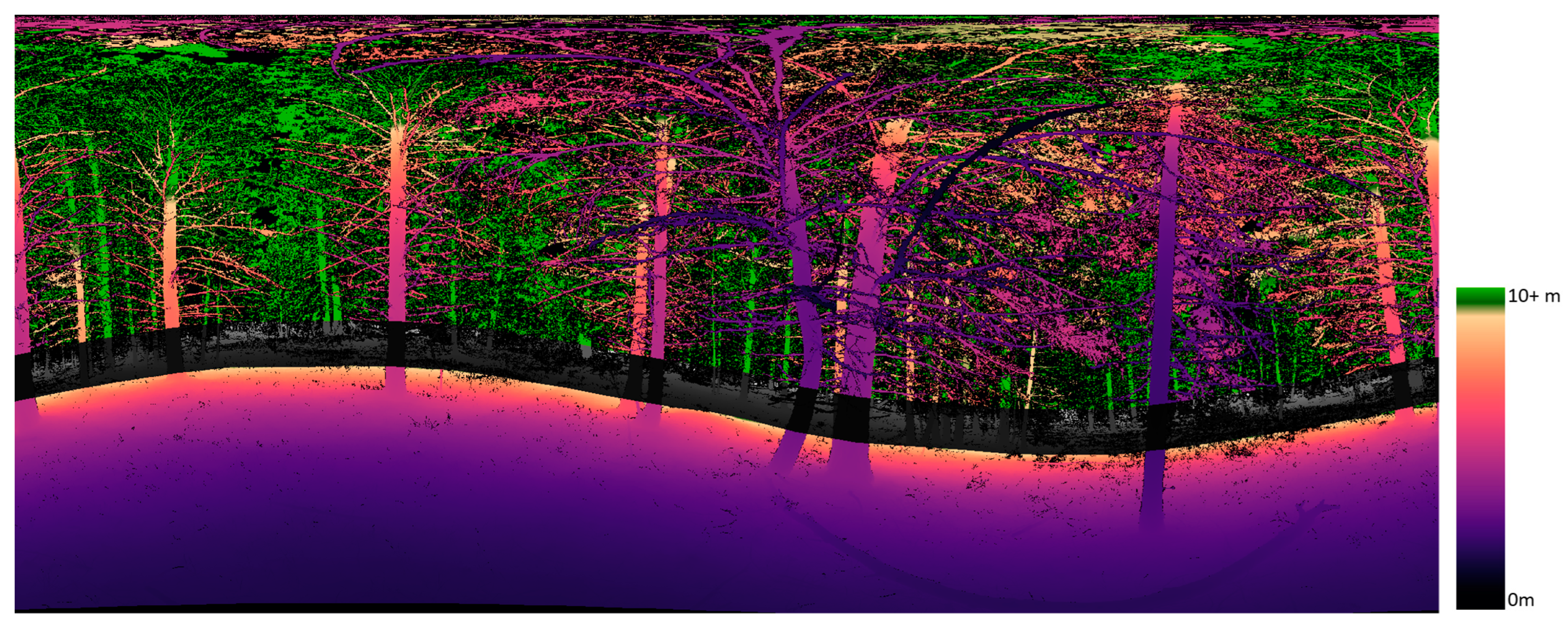
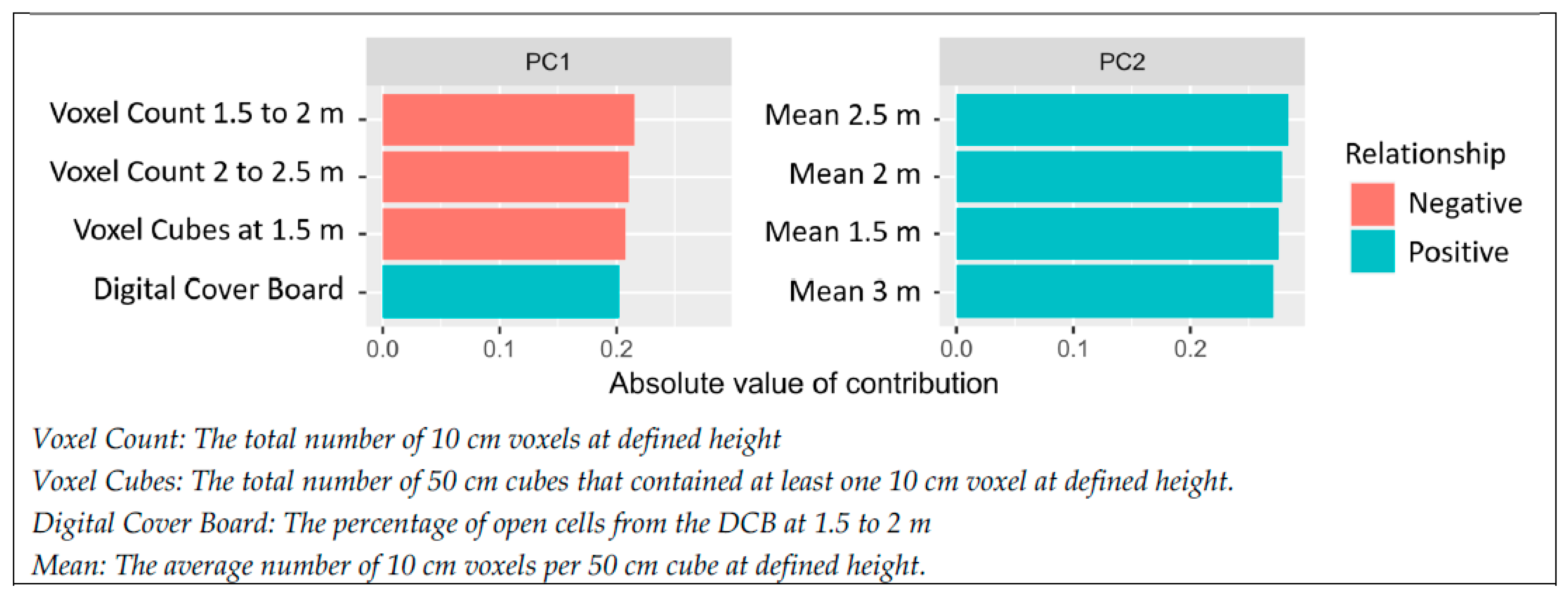
| 10 M DCB | Total percentage of cover, number of pixels, percentage of cover within 10 m, and mean distance and standard deviation of all pixels and cover pixels at 10 m (7 of the 42 metrics). |
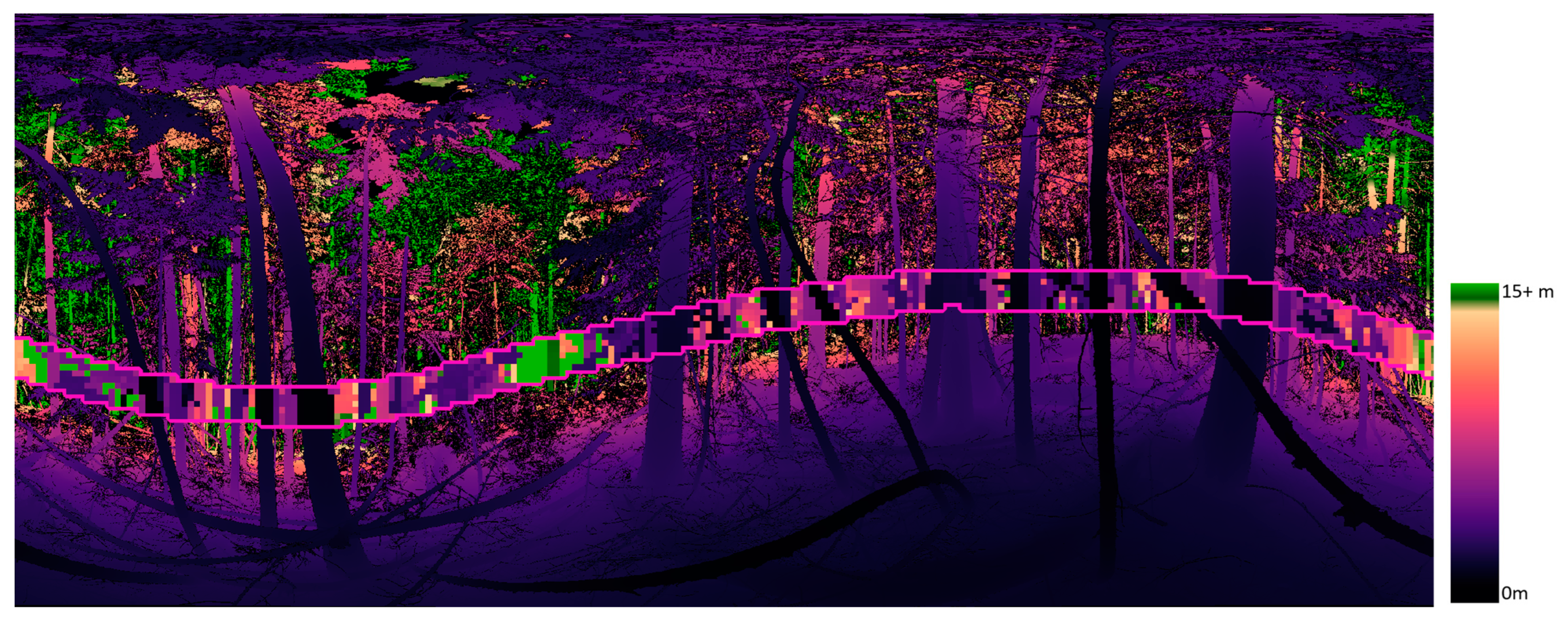
| 15 M DCB | Percentage of cover within 15 m per down-sampled pixel, percentage of cover within 15 m per vertical column of pixels, percentage of vertical columns with no cover, and mean distance and standard deviation of all pixels and cover pixels at 15 m (8 of the 42 metrics). |
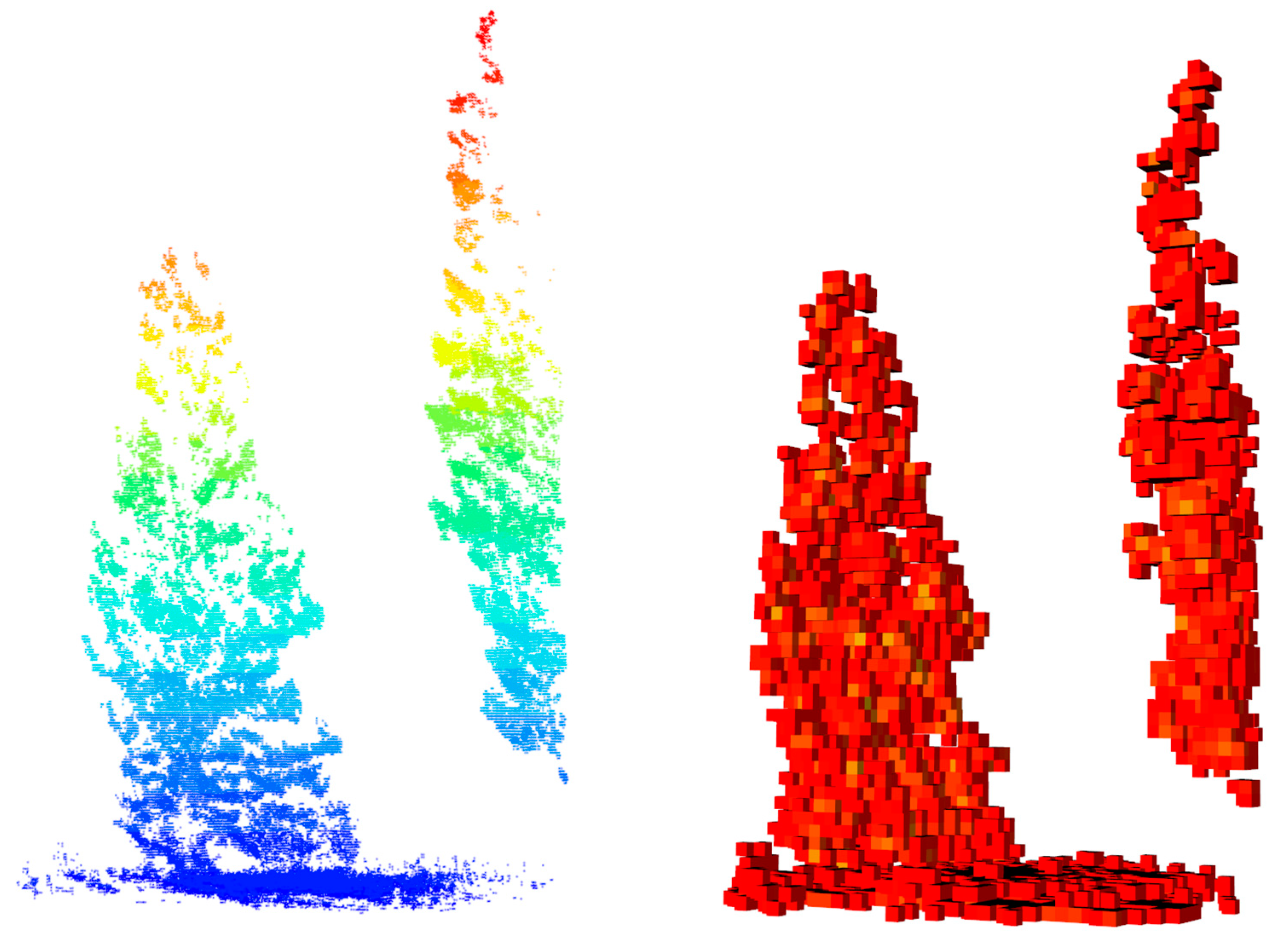
| VOXELIZATION | Total count of 10 cm voxels per 0.5 m height stratum, mean count of 10 cm voxels per 0.5 m cube, and count of 0.5 m cubes with 1 or more 10 cm voxels per height stratum (27 of the 42 metrics). |
| ALS METRICS | |
|---|---|
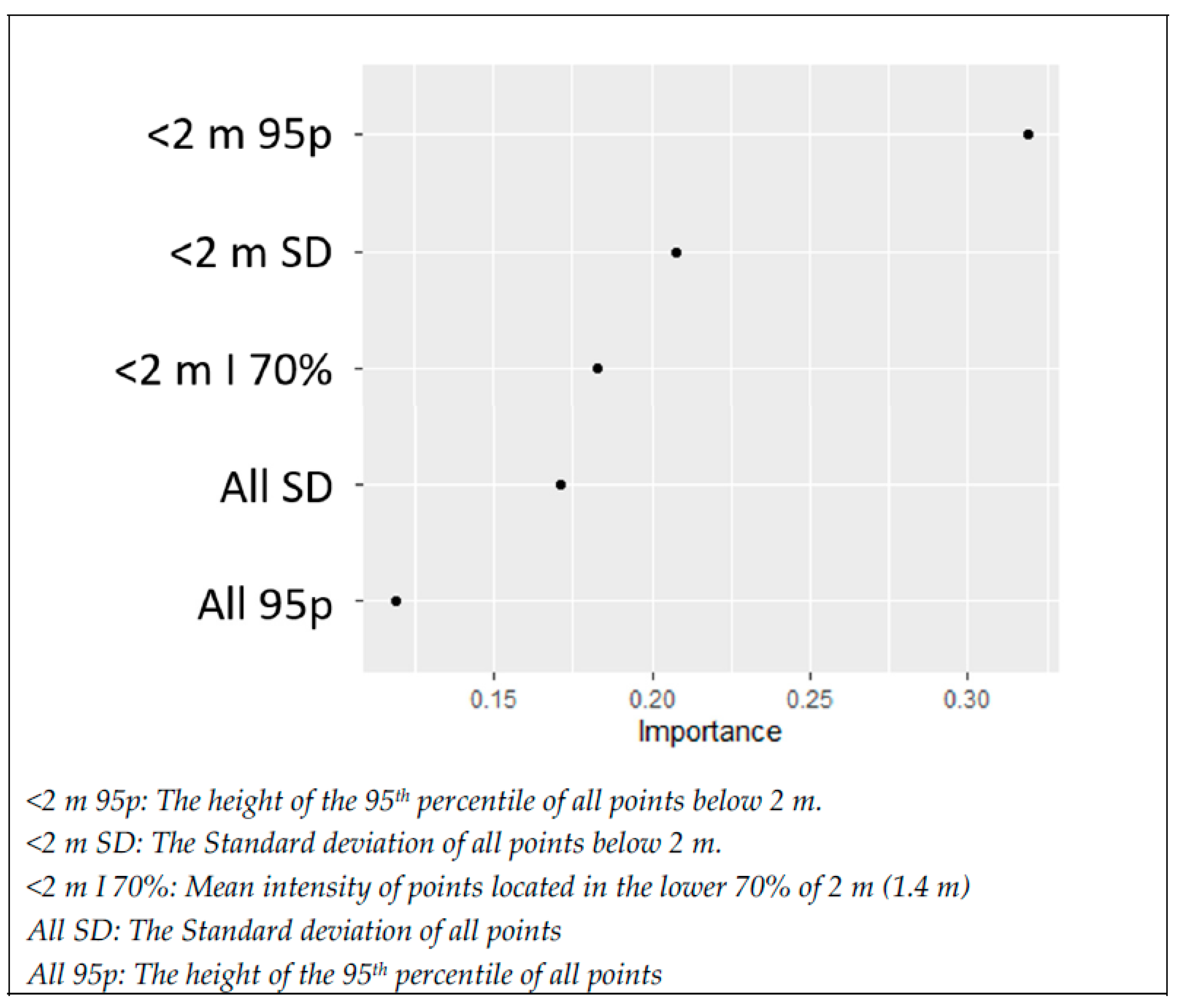
| POINTS USED | All points, only first returns, only last returns, all points < 2 m in height, and points > 0.5 m and <2 m in height (five groups of points). |
| Z AND INTENSITY METRICS | Count, sum, max, mean, standard deviation, skew, kurtosis, percentage above mean, 19 height percentiles (5th to 95th percentile), and mean intensity at height percentiles (47 per group, 235 total). |
| RATIOS | CPR for each point group (9 per group, 45 total), and ORD and NRD (6 total). |
Disclaimer/Publisher’s Note: The statements, opinions and data contained in all publications are solely those of the individual author(s) and contributor(s) and not of MDPI and/or the editor(s). MDPI and/or the editor(s) disclaim responsibility for any injury to people or property resulting from any ideas, methods, instructions or products referred to in the content. |
© 2023 by the authors. Licensee MDPI, Basel, Switzerland. This article is an open access article distributed under the terms and conditions of the Creative Commons Attribution (CC BY) license (https://creativecommons.org/licenses/by/4.0/).
Share and Cite
Batchelor, J.L.; Hudak, A.T.; Gould, P.; Moskal, L.M. Terrestrial and Airborne Lidar to Quantify Shrub Cover for Canada Lynx (Lynx canadensis) Habitat Using Machine Learning. Remote Sens. 2023, 15, 4434. https://doi.org/10.3390/rs15184434
Batchelor JL, Hudak AT, Gould P, Moskal LM. Terrestrial and Airborne Lidar to Quantify Shrub Cover for Canada Lynx (Lynx canadensis) Habitat Using Machine Learning. Remote Sensing. 2023; 15(18):4434. https://doi.org/10.3390/rs15184434
Chicago/Turabian StyleBatchelor, Jonathan L., Andrew T. Hudak, Peter Gould, and L. Monika Moskal. 2023. "Terrestrial and Airborne Lidar to Quantify Shrub Cover for Canada Lynx (Lynx canadensis) Habitat Using Machine Learning" Remote Sensing 15, no. 18: 4434. https://doi.org/10.3390/rs15184434
APA StyleBatchelor, J. L., Hudak, A. T., Gould, P., & Moskal, L. M. (2023). Terrestrial and Airborne Lidar to Quantify Shrub Cover for Canada Lynx (Lynx canadensis) Habitat Using Machine Learning. Remote Sensing, 15(18), 4434. https://doi.org/10.3390/rs15184434


