Article

Investigating the Performance of IGS Real-Time Global Ionospheric Maps under Different Solar Conditions

School of Geodesy and Geomatics, Hubei Luojia Laboratory, Wuhan University, Wuhan 430079, China
*
Author to whom correspondence should be addressed.
Remote Sens. 2023, 15(19), 4661; https://doi.org/10.3390/rs15194661
Submission received: 23 August 2023 / Revised: 14 September 2023 / Accepted: 19 September 2023 / Published: 22 September 2023

Abstract

:
In recent years, real-time global ionospheric map (RT-GIM) products have been actively developed by the international global navigation satellite system (GNSS) service (IGS) and its ionosphere associate analysis centers (IAACs) along with the increase of RT-GNSS multi-frequency and multi-constellation observations. In this study, the accuracy and consistency of three RT-GIM products from the Chinese Academy of Sciences (CAS), Wuhan University (WHU), and IGS are evaluated and analyzed utilizing three validation methods, namely, comparison with JASON-3 vertical total electron content (VTEC), the difference of slant total electron content (dSTEC), and IGS combined final GIM (IGSG) data. The test period was from 1 January 2019 to 31 December 2022, including the different solar activities. First, the comparison with JASON-3 data illustrates that the quality of the three RT-GIM products over oceans is in great consistency with that of the IGSG during different levels of solar activity and the daily mean bias (MEAN) values in low and high solar activities are approximately 5 and 10 TECU, respectively. The root mean square (RMS) values under low and high solar activities can be up to 7 and 12 TECU. Furthermore, the dSTEC validation results present that the MEAN values of RT-GIM products from different IAACs at high- and mid-latitude stations are about 0.5 TECU, which is smaller than those at low-latitude stations at about 1 TECU over continental regions. The standard deviation (STD) and RMS values for various RT-GIM products are within 3 and 4 TECU at low latitudes, respectively. In terms of the comparison with IGSG, the result shows that IGS combined RT-GIM (IRTG) presents better consistency than CAS RT-GIM (CRTG) and WHU RT-GIM (WRTG) in 2021 and 2022, with average annual STD and RMS values of 2.56 and 2.78 TECU, respectively. The daily biases of the RT-GIM products relative to IGSG can reach 4 TECU in high solar activities and the daily STD and RMS values are mainly within the 5 to 6 TECU range, respectively.

1. Introduction

For over a decade, the international global navigation satellite system (GNSS) service (IGS) has been dedicated to providing a high-accuracy real-time ionospheric service [1,2,3]. Some IGS ionosphere associate analysis centers (IAACs) have also been openly providing real-time global ionospheric map (RT-GIM) products with a spatial resolution of 5° (longitude) × 2.5° (latitude) in the uniform IONosphere map EXchange (IONEX) format based on GNSS multi-frequency and multi-constellation observations from 2016 [4,5,6,7]. In 2018, the first IGS combined RT-GIM was also generated with the contribution of IGS RT-GIMs from the Chinese Academy of Sciences (CAS), Centre National d’Etudes Spatiales (CNES), and Universitat Politècnica de Catalunya (UPC) [8]. These RT-GIM products can contribute to continuously monitoring and detecting, in real-time, the spatiotemporal distribution and variation of the ionosphere but, also, the motion of natural hazards, such as earthquakes, landslides, volcanic activities, and tsunamis [9,10,11]. Additionally, the RT-GIM products are conducive to real-time correction of the ionospheric delay for single-frequency precise point positioning (PPP) and reducing the convergence time of dual-frequency PPP [7]. Therefore, it is imperative to validate the accuracy and consistency of RT-GIM products from various IGS IAACs in detail.
At present, the performance evaluation of global ionospheric maps (GIMs) mainly focuses on the final, rapid, and predicted products [12,13,14,15,16]. The rapid and final GIM products have performed with a higher accuracy of 2.0–8.0 total electron content unit (TECU; 1 TECU = 1016 el/m2); but, they are commonly accessible with latencies of 1–2 days and 2–4 weeks, respectively, owing to data latencies and computation conventions [17,18,19]. Meanwhile, the 1- and 2-day predicted GIM without latency is limited in accuracy owing to the nonlinear variation of the ionosphere, especially during high solar activities or geomagnetic storms [14]. In this context, we attach more attention to the quality of the RT-GIM products. For the RT-GIM products, some surveys have investigated the accuracy from various aspects. Ren et al. [7] first assessed the quality of three RT-GIM products from Wuhan University (WHU), UPC, and the CAS between 2016 and 2018 and showed that the performance of the CAS RT-GIM products was slightly greater than the UPC and WHU RT-GIM products; but, all RT-GIM products were a little less accurate than the one-day predicted GIM products from the Center for Orbit Determination in Europe (CODE) for the test period. Li et al. [6] evaluated the accuracy and consistency of RT-GIM products from the CAS, CNES, and UPC during low solar activities (approximately 16 months beginning from September 2017) and found that the CAS RT-GIM products outperform the UPC RT-GIM products by about 4.5% and are slightly worse than the CAS final GIM products about 1.7–4.9%. Since 4 January 2021, a new version of IGS RT-GIM products has been publicly and routinely generated; Liu et al. [20] validated the RT-GIM products using the JASON-3 altimeter for approximately three months, from 1 December 2020 to 1 March 2021, over oceans and the difference of slant total electron content (dSTEC) assessment over only two days over continents. The result demonstrated that the RT weighting method was sensitive to the performance of the RT-GIM products and the accuracy of the UPC RT-GIM and new IGS combined RT-GIM products was close to that of the rapid GIM products during the experimental period. Nevertheless, it is noted that the mentioned investigations about the RT-GIM products were in low solar activities and analyzed during the initial release of RT-GIM products in an experimental way.
Through the above analysis, it is essential to further investigate the performance of different RT-GIM products in detail and the reasons are as follows. Firstly, the RT-GIM products are becoming a reliable data source for related real-time scientific research and technological applications, as mentioned above. Secondly, to the best of our knowledge, the quality and consistency of those RT-GIM products are not validated and analyzed during different solar activities, especially in high solar activities. In addition, different IAACs are also constantly improving the quality of their RT-GIM products by optimizing RT-GIM calculation strategies and utilizing increasing global multi-frequency and -constellation GNSS observations. It is desirable for us to study the current accuracy and reliability of those RT-GIM products and the new IGS combined RT-GIM products instead of analyzing only that of those RT-GIM products in an experimental or initial way. Hence, the comprehensive performance of three RT-GIM products from the CAS, WHU, and IGS has been analyzed and discussed for four years (from 1 January 2019 to 31 December 2022) in this work.
Other parts of this manuscript are organized. Section 2 presents the data sets and validation methodologies for three RT-GIM products from three different aspects, including comparison with JASON-3 vertical total electron content (VTEC), the dSTEC observations, and IGS combined final GIM data. The evaluation results obtained using these validation methodologies for those RT-GIM products are shown in detail in Section 3. Finally, Section 4 and Section 5 present the discussion and conclusion.

2. Materials and Methods
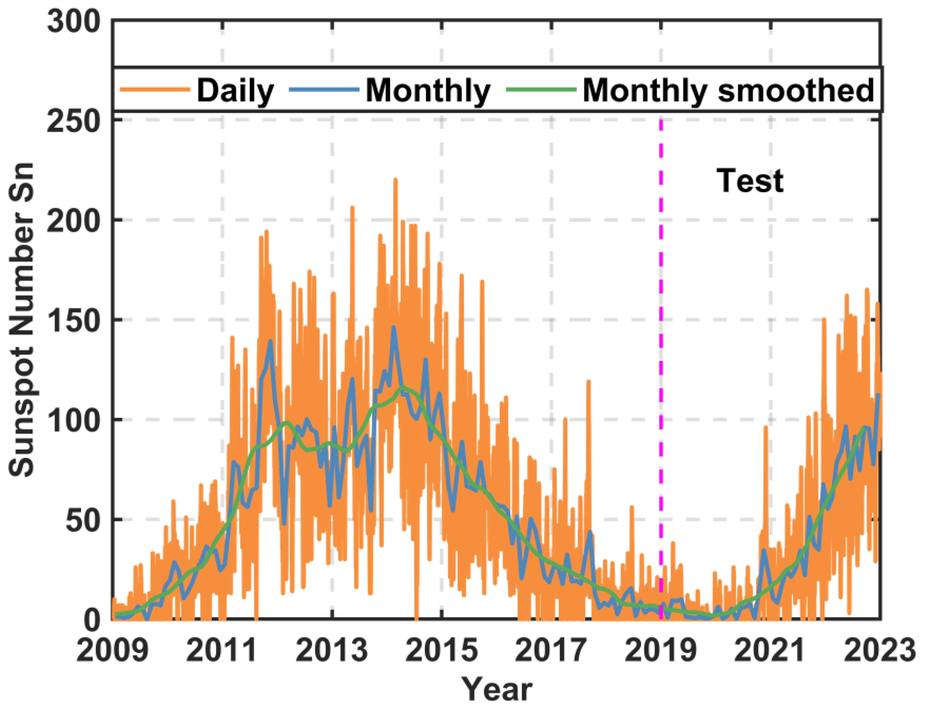
2.1. Data Sets

As the level of solar activity has a significant influence on the Earth’s ionosphere [20,21,22], the experimental period is selected to be four years, from 1 January 2019 to 31 December 2022. Figure 1 depicts the daily, monthly, and 13-month smoothed sunspot numbers [23] from 2009 to 2022; the daily sunspot number exceeds 150 in 2022 of solar cycle 25 and is close to the high solar activity level of cycle 24. The test period includes different solar activities and is conducive to giving a statistically representative result for those RT-GIM products.
Since the adopted strategies for calculating RT-GIMs are different among various IGS real-time IAACs, a brief strategy comparison of different RT-GIM products using their own software from various IAACs is summarized in Table 1. It can be found that the spatial resolution of all RT-GIM products is 5° (longitude) × 2.5° (latitude) in the uniform IONEX format; but, the temporal resolution of the CAS RT-GIM (CRTG) and WHU RT-GIM (WRTG) is every 5 min while that of the IRTG is 20 min. For the method, the CAS and WHU both use spherical harmonic (SH) expansion (15 × 15) [5]; the IRTG is based on the weighted mean value of ionospheric VTEC from different real-time IAACs, shown as Equation (1) [20]. The calculation strategies are different between the CRTG and WRTG, such as the shell height, GNSS observation, and differential code bias (DCB) computation. The shell altitude of the CRTG products is 400 km, which is different from the 450 km of the WRTG and IRTG products. Meanwhile, the slant TEC (STEC) observables are extracted by multi-GNSS signals for generating the CRTG, including GPS and GLONASS (L1 and L2), BeiDou system (BDS; B1 and B2), and Galileo (E1 and E5a); RT GNSS stations from the IGS, multi-GNSS experiment (MGEX), and some national/regional GNSS networks are used to generate the CRTG [6]. The WRTG only adopts the GPS RT data streams from approximately 130 MGEX stations. In terms of the DCB computation, the satellite and receiver DCBs from CAS are pre-determined in a local ionospheric analysis [6]. Firstly, the satellite-plus-receiver DCBs are estimated as part of the local ionospheric vertical total electron content (VTEC) modeling utilizing a modified generalized triangular series function, as shown in Equation (2) [24]. Further, a zero-constellation-mean constraint is employed to remove the rank deficiency in the calculation of satellite- and receiver-specific DCBs. Finally, a 1-day DCB solution is calculated utilizing 24 h measurement arcs and 3-day aligned biases are incorporated to increase the robustness of real-time DCB estimates [24,25]. The WRTG adopts the previous DCBs of the rapid GIM products [20].
{ V T E C I R T G , t = g = 1 N A C ( w g , t · V T E C g , t ) w g , t = I g , t / g = 1 N A C ( I g , t ) I g , t = 1 / R M S δ , g , t 2 R M S δ , g , t 2 = r = 1 N t ( δ g , t ) 2 / N t
where VTECIRTG,t and VTECg,t are the VTEC of the IGS RT-GIM and RT-GIM g from the individual IAAC at epoch t, respectively. NAC denotes the number of the IGS IACCs.  w g , t  stands for the weight of the individual RT-GIM  g  at epoch  t I g , t  signifies the inverse of the mean square of the real-time dSTEC (RT-dSTEC) error at epoch  t R M S δ , g , t  represents the RMS of the RT-dSTEC error at epoch  t N t  denotes the number of RT-dSTEC observations between the beginning and the current epoch  t δ g , t  stands for the RT-dSTEC error of the individual RT-GIM  g  at epoch  t .
{ S T E C t = M z V T E C t + c ( D s + D r ) V T E C t = i = 0 i m a x j = 0 j m a x { E i , j φ d i λ d j } + l = 0 l m a x { C l c o s ( l · h t ) + S l s i n ( l · h t ) } h t = 2 π ( t 14 ) / T , T = 24 h i m a x = j m a x = 2 l m a x = 4
where  r  and  s  represent the receiver and satellite, respectively.  φ d  and  λ d  stand for the difference between the ionospheric pierce point (IPP) and GNSS station in latitude and longitude, respectively.  i j  and  l  are the degrees in the polynomial model and Fourier series expansion.  E i , j C l  and  S l  denote the unknown parameters.
Then, Figure 2 shows the availability of RT-GIM products released by the CAS, WHU, and IRTG provided by UPC; a detailed description of their RT-GIM computation procedures can be found in [3,6,16,20,24]. It can be found that IAAC at the CAS stably offered RT-GIM products for the test period in addition to the latter half of 2022. The new IGS combined RT-GIM products were also routinely released after 2021 and the IGS RT-GIM products also further adopted parallel computing and changed the real-time interpolation strategies to reduce the latency of the RT-GIM calculation. WHU continued to provide the RT-GIM products after updating the computation strategies and continuously released them since 2021. To compare and analyze the availability difference between the individual RT-GIM product and the final GIM products, the availability of the IGS combined final GIM products is also displayed in the figure.

2.2. Validation against JASON VTEC

The JASON-3 altimetry satellite with a mean orbital altitude of approximately 1336 km can directly obtain the JASON-3 VTEC observations using the dual-frequency signals, i.e., Ku-band (13.575 GHz) and C-band (5.3 GHz) [26,27]. The calculation formula of the JASON-3 VTEC is expressed as Equation (3) below [28,29]. The sampling frequency of the JASON-3 satellite is 1 Hz [12]. In order to alleviate the influence of inherent noise on the JASON-3 VTEC result, we have applied 16 s median smoothing [2,20] to the ionospheric VTEC data in this manuscript. Figure 3 displays the distribution of the IPPs of the JASON-3 satellite within one day (1 January 2020) over oceans; its coverage is mainly between 66.15°S and 66.15°N latitudes [4,30].
V T E C J ason = d R K f K 2 40.3 × 10 16
where  d R K  and  f K  represent the ionospheric delay correction and the frequency of Ku-band in GHz, respectively.
Additionally, it is worth noting that the JASON-3 VTEC observations have a systematic bias relative to GNSS ionospheric TEC values of about 2.0–5.0 TECU owing to the ionosphere above the orbit of the JASON-3 satellite and the differences in the tracking patterns, measuring principles, and calculation strategies between the GNSS and JASON-3 satellites [11]. However, the JASON VTEC observations are still an independent ionospheric data source and are one of the most accurate ionospheric TEC observations over global oceans, especially being far from GNSS receivers [1,2,12]. Consequently, this study utilizes the JASON-3 ionospheric VTEC data to validate the accuracy performance of various RT-GIM products over oceans. Additionally, the temporal resolution between the JASON-3 VTEC and those RT-GIM products from various IAACs is different and, thus, the ionospheric VTEC values of RT-GIM products need to be of a linear interpolation to be compared with the JASON-3 VTEC data at the corresponding epoch [7,12].

2.3. Validation against the GNSS dSTEC

In this section, the dSTEC is the difference of the ionospheric STEC relative to that at the highest elevation in the same phase-continuous arc and can be derived by the GNSS dual-frequency phase measurements [31]. Owing to the advantages of the lower noise and the multipath effects, the accuracy of the dSTEC is greater than 0.1 TECU [2]. In addition, the GNSS dSTEC values are free from any assumptions and models [32]; thus, the dSTEC is also applied to validate the accuracy of different GIM products. Here we give only a brief description, as follows, and readers are referred to [1,33] for more details of the dSTEC method.
d S T E C L 4 ( t ) = S T E C L 4 ( t ) S T E C E max = 40.3 10 16 f 1 2 r ( L 4 ( t ) L 4 , E max )
where  S T E C L 4 ( t )  and  S T E C E max  stand for the STEC along the line of sight at the epoch t and at the highest elevation in the same continuous arc, respectively.  L 4 = L 1 L 2  denotes the geometry-free combination value.  L 1  and  L 2  represent phase measurements at the frequencies f1 and f2 r  is a constant and equals to  1 f 1 2 / f 2 2 .
Note that the temporal resolution of RT-GIM products from CAS and WHU is every 5 min and that of the IRTG is every 20 min; the spatial resolution of all RT-GIM products is 5° (longitude) × 2.5° (latitude) and RT-GIM products provide ionospheric VTEC information. Meanwhile, the dSTEC value is the ionospheric STEC information. Therefore, the RT-GIM will be interpolated to the required time and locations and convert the ionospheric VTEC information to the ionospheric STEC values using the modified single-layer mapping function [5].
To provide a fair validation and analysis for different RT-GIM products, the GNSS stations that are not used for the generation of RT-GIM products by any of the involved IAACs are often utilized for assessment. However, the number of available real-time GNSS stations currently is limited. Alternatively, we adopted GNSS stations that contributed to the establishment and generation of all RT-GIM products via the involved IAACs in the dSTEC assessment and a set of 18 RT-GNSS stations over continental regions were carefully selected [6,12]. The distribution of those RT-GNSS receivers for dSTEC assessment is displayed in Figure 4; the distribution of those RT-GNSS receivers is relatively uniform at various latitudes, which is conducive to validating the accuracy and self-consistency of various RT-GIM products.

2.4. Validation against the IGS Combined Final GIM

At present, seven IGS IAACs, the CAS, CODE, UPC, WHU, European Space Operations Center of European Space Agency, JetPropulsion Laboratory, and Natural Resources Canada, have independently released the final GIM products calculated by multi-frequency and multi-constellation GNSS observations [5,6,7,34]; different IAACs adopt different GNSS stations, model technologies, and calculation strategies [15,16,17]. The accuracy of the different final GIM products from various IAACs is approximately 2.0–8.0 TECU (http://www.igs.org/products (accessed on 3 September 2023)). To provide comprehensive final GIM products, the IGS generates the final GIM with a weighted mean of some final GIM products from these IAACs [1,12]. Previous investigation illustrated that the IGSG is one of the highest precision final GIM products [12,13,14] and, thus, it is also used to validate the performance of different RT-GIM products.

2.5. Statistical Indices

Three statistical indices are selected to evaluate the accuracy and consistency of those RT-GIM products from various IAACs, including the mean bias (MEAN), standard deviation (STD), and root mean square (RMS) of the difference between RT-GIM TEC and the reference TEC values; the corresponding equations are presented below.
M E A N = 1 n i = 1 n ( T E C i G I M T E C i r e f ) S T D = 1 n i = 1 n ( T E C i G I M T E C i r e f M E A N ) 2 R M S = 1 n i = 1 n ( T E C i G I M T E C i r e f ) 2
where n is the total number of samples,  T E C i G I M  denotes the ionospheric TEC values obtained from different RT-GIM products;  T E C i r e f  stands for the reference TEC values derived from the JASON-3 altimeter satellite, GNSS, or the IGS combined final GIM products.

3. Results

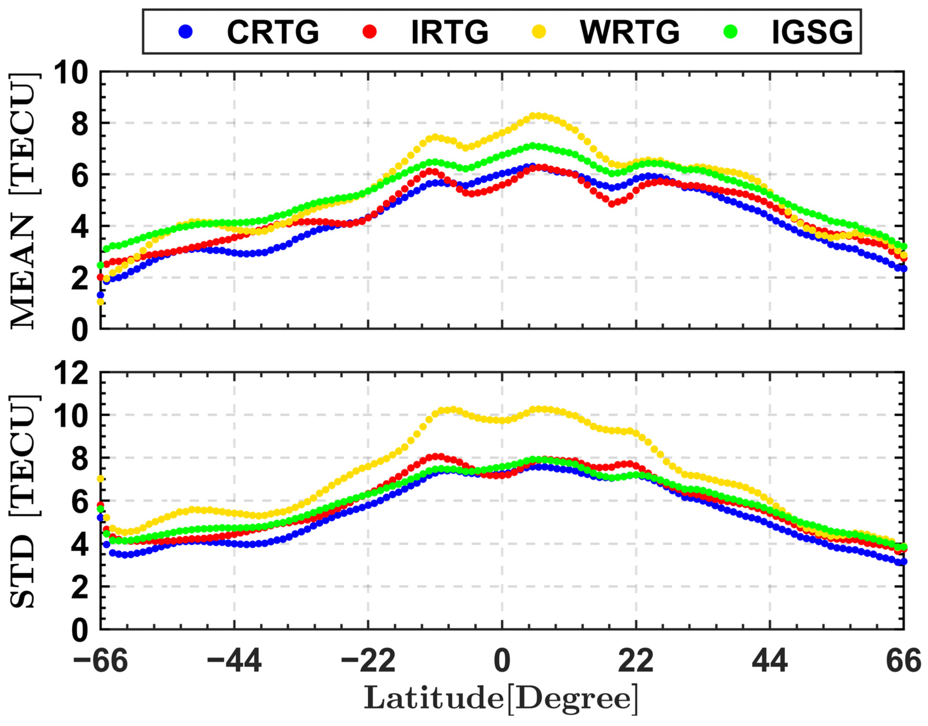
3.1. Validation against JASON VTEC

Figure 5 shows the time series of the MEAN, STD, and RMS values per day between the different RT-GIM products and JASON-3 data from 1 January 2019 to 31 December 2022. As we can see from the figure, the MEAN, STD, and RMS values of the different IAAC RT-GIM products, overall, display a significant upward trend with the increase of solar activity. When solar activity levels are low from 2019 to 2020, the MEAN values of the different RT-GIM products relative to the JASON-3 VTEC are basically within 5 TECU and the RMS is within 7 TECU. As the levels of solar activity increase, especially in 2022 (the daily sunspot number exceeds 150, as shown in Figure 1), the daily MEAN, STD, and RMS values can be up to approximately 10, 8, and 12 TECU, respectively. The positive difference (i.e., VTEC[RT-GIM] > VTEC[JASON-3]) is mainly related to the contribution of the plasmaspheric electron content between JASON-3 and the GNSS satellite orbital altitude [6,35]. Meanwhile, the daily MEAN, STD, and RMS values of those RT-GIM products and the IGSG with regard to the JASON-3 VTEC data show the apparent periodic terms, such as semi-annual and annual cycles, especially in years of high solar activity. Additionally, all three subplots show that the accuracy and consistency of those RT-GIM products from the different IAACs with regard to JASON-3 data over the oceans are in good agreement with those of the IGS final GIM during different levels of solar activity.
Further, the latitudinal behavior of the different RT-GIM products relative to JASON-3 data is shown in Figure 6. The distribution coverage of the JASON-3 VTEC is mainly from 66°S to 66°N in latitude and the result is calculated from daily average values within 1° latitudinal bins for the experimental period. It can be seen that the MEAN and STD values of all RT-GIM products present the typical inverted U shape in terms of the latitude and the performance of the RT-GIM and final GIM products in low latitudes is less than that in middle and high latitudes, which is mainly associated with the intense variability of the ionosphere in equatorial and low latitudes and the inadequacy of the single-layer assumption at larger latitude gradients [6,36]. At the same time, although there is good consistency among the different RT-GIM products, except for the WHU RT-GIM products in low latitudes, the different RT-GIM products have some systematic deviation (approximately 2 to 3 TECU) with regard to the JASON-3 VTEC data at various latitudes; it is mainly related to the plasmaspheric electron content above the top of JASON-3 and is consistent with Figure 5. In addition, the STD values of different RT-GIM products in the northern hemisphere are slightly better than those in the southern hemisphere and the hemispheric asymmetry is mainly associated with the relatively limited number of GNSS monitors in the southern hemisphere, especially in the oceanic regions [15,17].

3.2. Validation against the GNSS dSTEC

To further assess the performance of the different RT-GIM products, Figure 7 presents the statistical results of the daily dSTEC values of various RT-GIM products for the test period. Whether the solar activity is high or low, the MEAN values of the RT and final GIM products are basically within 1 TECU and the dSTEC value of the IGS final GIM products is the smallest and most stable at around 0 TECU. The results of the daily STD and RMS values show that all RT-GIM products are in agreement with the solar activities and the STD and RMS values are within 1.5 and 2 TECU during low solar conditions, respectively, while they are 3 and 4 TECU during high solar conditions, respectively. On the other side, the statistical RMS differences of the dSTEC between the IGSG and individual RT-GIM products are mainly smaller than 1 TECU in both high and low solar activities and the trend of RMS variation between the two with the obvious semi-annual and annual cycles is consistent.
To investigate the consistency of the dSTEC values among the different RT-GIM products, Figure 8 presents the MEAN, STD, and RMS values of the dSTEC for all GNSS stations from the day of year (DOY) 188, 2021 to the DOY 129, 2022, when RT-GIM products are available in all three IAACs. All GNSS stations are evenly distributed at various latitudes, as displayed in Figure 4. The results show that the accuracy of GNSS stations at high and middle latitudes is higher than that of the GNSS stations gamb, reun, ascg, seyg, ptgg, and lpal at low latitudes. Regarding the absolute MEAN, the dSTEC values at high- and mid-latitude GNSS stations are within 0.5 TECU while those at low-latitude stations can reach up to 1 TECU, such as seyg. The STD and RMS values of the dSTEC values are within 3 and 4 TECU at low latitudes, respectively. Although there are some differences in accuracy between the RT-GIM and final GIM products, the difference of the STD and RMS values between the RT-GIM and final GIM products is basically within 1 TECU, even in low-latitude areas. Overall, the accuracy of the RT-GIM products is slightly worse than final GIM products as a result of relatively fewer real-time GNSS stations, a shorter span of observations, and higher noises in carrier-to-code leveling [25]. And, the performance of the IGS RT-GIM products is slightly greater than the other two RT-GIM products from the IAACs of the CAS and WHU, respectively, demonstrating that the real-time weighting method is sensitive to the quality of the RT-GIM products.

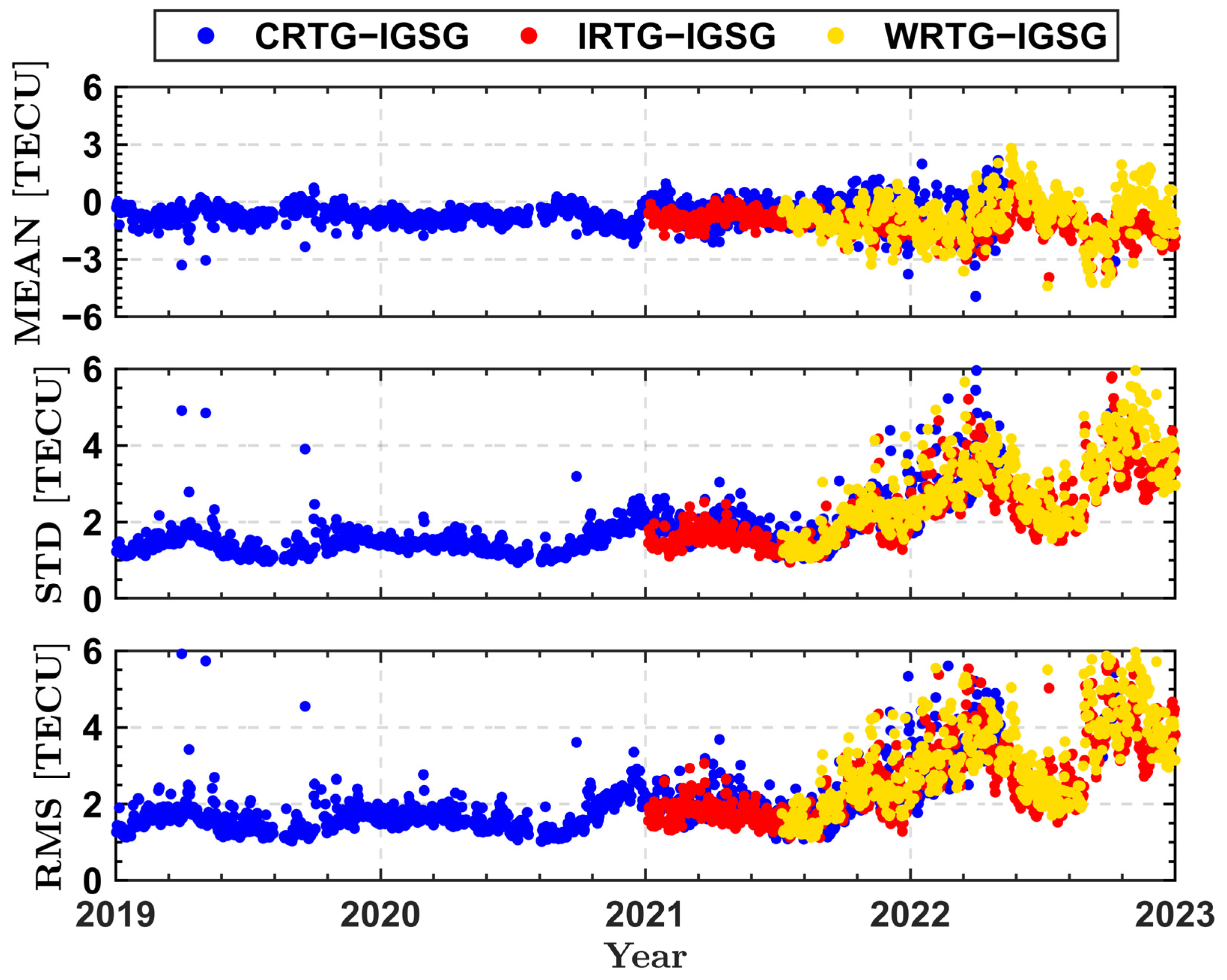
3.3. Validation against the IGS Combined Final GIM

Figure 9 illustrates the daily MEAN, STD, and RMS values of the difference between the different RT-GIM products and IGS final GIM products for the entire experimental test. Corresponding to the solar activities in Figure 1, the variations of the MEAN, STD, and RMS values of RT-GIM products from different IAACs with regard to the IGSG are apparently related to the level of solar activities. In particular, the bias values are stable around approximately 0 TECU during the low solar activities from DOY 001, 2019 to DOY 366, 2020 while the daily biases of the RT-GIM products relative to the IGSG can reach 4 TECU after 2022. Regarding the daily STD and RMS, the daily STD and RMS values approximately range from 1 to 2 TECU and 1 to 3 TECU under the levels of low solar activities, respectively, while they range from 1 to 5 TECU and 1 to 6 TECU under the levels of high solar activities, respectively, which is associated with more difficulties of ionospheric TEC modeling at higher gradients owing to equatorial ionospheric anomalies, the enhanced photoionization, and particle precipitation [1]. Also, it can be found that different RT-GIM products compared with the IGSG have great consistency, even in high solar activity.
Table 2 gives the annual statistic values of different RT-GIM products compared with the IGSG for the test period. The annual STD and RMS values between individual RT-GIM products and the IGSG increase with rising solar activities and reach the maximum in 2022, the year with the highest solar activity for the experimental period. Compared to the other two RT-GIM products, the IRTG and IGSG from 2021 to 2022 showed better agreement, with average STD and RMS values of 2.56 and 2.78 TECU, respectively.
The difference values of individual RT-GIM products with regard to the IGSG on DOY 004, 2022 are presented in Figure 10, which can directly show the difference distribution of different RT-GIM products with regard to the IGS combined final GIM product. It can be found that the maximum bias is approximately 10 TECU and the difference of the different RT-GIM products compared with the IGSG mainly occurs at low latitudes and in the southern hemisphere oceanic regions (typically far from GNSS receivers), such as the Pacific Ocean and polar regions. Among these RT-GIM products, the performance of the IRTG relative to the IGSG, overall, is slightly better than that of the other two.

4. Discussion

In this study, the performance of the ionospheric TEC of three RT-GIM products is evaluated and analyzed under various solar activities. In addition to the ionospheric TEC information, the estimated RMS information that can provide the standard deviations of the corresponding TEC errors is also a significant part of RT-GIM products in the IONEX format [37]. Broadcasting the RMS information could be beneficial to precise point positioning (PPP) users [20,38]. Previous studies have utilized the RMS maps of rapid and final GIM products to assign the appropriate weights for the GNSS measurements in the PPP model in order to shorten the convergence time [38,39,40]. Currently, WHU provided the estimated RMS errors along with the real-time VTEC maps while the CAS proposed an associated quality indicator for the real-time VTEC maps [41]. The corresponding RMS information is not yet available from the IRTG. With further increasing RT-GNSS multi-frequency and multi-constellation observations, the ionospheric TEC and corresponding RMS information from different IAACs will become more accurate and reliable. It will be very interesting to validate the accuracy and consistency of those real-time RMS maps from different IAACs under different solar activities and apply more accurate real-time RMS information to the PPP model to reduce the corresponding convergence time.
Additionally, since the number of currently available RT-GNSS stations is limited, we selected partially “internal” RT-GNSS stations to assess the performance of those RT-GIM products in the dSTEC validation; those “internal” stations are utilized in the independent computation of the three RT-GIM products. With the increasing number of RT-GNSS receivers in the future, the dSTEC validation can adopt the “external” instead of the “internal” RT-GNSS receivers. The“external” RT-GNSS receivers are not utilized by any real-time IAACs in their GIM computation, which would be a preferred option in the dSTEC validation [6] and has been used to validate the performance of the final and rapid GIM products in related studies [1,2,12].

5. Conclusions

Increasing RT-GNSS multi-frequency and multi-constellation observations provide a great opportunity for generating more accurate and reliable RT-GIM products. Meanwhile, RT-GIM products can contribute to continuously monitoring and detecting the spatiotemporal variation of the ionosphere in real-time but also the motion of the natural hazards. Therefore, it is of great significance to investigate the accuracy of the RT-GIM products. In this paper, the accuracy validation for the three RT-GIM products from the CAS, WHU, and IGS is carried out under different solar activities, in detail, by different assessment methods, including the comparison with the JASON-3 VTEC, dSTEC, and IGSG data.
In comparison with the JASON VTEC, the quality of the three RT-GIM products over the oceans is in great consistency with that of the IGSG during different levels of solar activity. Meanwhile, the accuracy of RT-GIM products decreases with the increase in solar activity. The daily MEAN values of different RT-GIM products relative to JASON-3 VTEC data under low and high solar activities can reach approximately 5 and 10 TECU, respectively. The RMS values under low and high solar activities can be up to 7 and 12 TECU. In addition, the STD values of the different RT-GIM products in the northern hemisphere are slightly better than those in the southern hemisphere.
The dSTEC validation results show that the accuracy of RT-GIM products at high- and mid-latitude stations is higher than at low-latitude stations; MEAN values at high- and mid-latitude GNSS stations are within 0.5 TECU while those at low-latitude stations can reach up to 1 TECU. The STD and RMS values for various RT-GIM products are within 3 and 4 TECU at low latitudes, respectively. Additionally, the daily RMS values for the three RT-GIM products present great consistency with the level of solar activities and RMS values in low and high solar conditions are mainly approximately 2 and 4 TECU, respectively. Additionally, the differences in the STD and RMS values between the RT-GIM and IGSG are mainly within 1 TECU, even in low-latitude GNSS stations.
The comparison with the IGSG displays that different RT-GIM products, when compared with the IGSG, have great consistency, even in high solar activity; the IRTG and IGSG display better consistency with average annual STD and RMS values of 2.56 and 2.78 TECU, respectively, than the CRTG and WRTG in 2021 and 2022. The daily biases of the RT-GIM products relative to the IGSG are approximately 4 TECU in high solar activities and the difference between the two mainly occurs at low latitudes and in the southern hemisphere oceanic regions. Regarding the daily STD and RMS values, they are mainly within 5 and 6 TECU, respectively.

Author Contributions

Conceptualization, X.R. and H.L.; Funding acquisition, X.R.; Investigation, H.L.; Methodology, H.L. and X.R.; Software, X.R. and H.L.; Validation, H.L. and G.X.; Writing—original draft, H.L.; Writing—review and editing, X.R., H.L. and G.X. All authors have read and agreed to the published version of the manuscript.

Funding

This work was funded by the National Natural Science Foundation of China (no. 42174031, no. 42230104) and the Fundamental Research Funds for the Central Universities.

Data Availability Statement

The Chinese Academy of Sciences (CAS) real-time global ionospheric map (RT-GIM) products and international GNSS service (IGS) combined final GIM products are collected by the CAS and can be obtained from the following website: https://apps.ecmwf.int/datasets/ (accessed on 3 September 2023). The Wuhan University (WHU) RT-GIM products can be downloaded from the following link: ftp://igs.gnsswhu.cn/pub/whu/MGEX/realtime-ionex (accessed on 3 September 2023). The IGS RT-GIM products are publicly available from http://chapman.upc.es/irtg/ (accessed on 3 September 2023). The GNSS data from the IGS stations are available via the different IGS data centers: ftp://cddis.gsfc.nasa.gov/pub/gps/data/daily/ (accessed on 3 September 2023). The data of the JASON-3 files can be downloaded from the following website: ftp://data.nodc.noaa.gov/pub/data.nodc/ (accessed on 3 September 2023). The sunspot number data can be found at https://www.sidc.be/silso/datafiles (accessed on 3 September 2023).

Acknowledgments

Many thanks are due to the IGS, CAS, and WHU for providing access to the ionospheric final and RT-GIM products. We are also grateful to the IGS for providing global navigation satellite system (GNSS) observation and navigation data. Meanwhile, we would like to cordially thank Centre National d’Etudes Spatiales (CNES) and the National Aeronautics and Space Administration (NASA) for the JASON-3 data. The World Data Center SILSO, Royal Observatory of Belgium, Brussels is also acknowledged for releasing sunspot number series data.

Conflicts of Interest

The authors declare no conflict of interest.

References

  1. Hernández-Pajares, M.; Roma-Dollase, D.; Krankowski, A.; García-Rigo, A.; Orús-Pérez, R. Methodology and consistency of slant and vertical assessments for ionospheric electron content models. J. Geod. 2017, 91, 1405–1414. [Google Scholar] [CrossRef]
  2. Roma-Dollase, D.; Hernández-Pajares, M.; Krankowski, A.; Kotulak, K.; Ghoddousi-Fard, R.; Yuan, Y.; Li, Z.; Zhang, H.; Shi, C.; Wang, C.; et al. Consistency of seven different GNSS global ionospheric mapping techniques during one solar cycle. J. Geod. 2018, 92, 691–706. [Google Scholar] [CrossRef]
  3. Caissy, M.; Agrotis, L.; Weber, G.; Hernandez-Pajares, M.; Hugentobler, U. The international GNSS real-time service. GPS World 2012, 23, 52–58. [Google Scholar]
  4. Schaer, S.; Gurtner, W.; Feltens, J. IONEX: The ionosphere map exchange format version 1. In Proceedings of the IGS AC Workshop, Darmstadt, Germany, 9–11 February 1998. [Google Scholar]
  5. Schaer, S. Mapping and Predicting the Earth’s Ionosphere Using the Global Positioning System. Ph.D. Thesis, Astronomical Institute, University of Bern, Bern, Switzerland, 1999. [Google Scholar]
  6. Li, Z.; Wang, N.; HernandezPajares, M.; Yuan, Y.; Krankowski, A.; Liu, A.; Zha, J.; GarciaRigo, A.; Roma-Dollase, D.; Yang, H.; et al. IGS real-time service for global ionospheric total electron content modeling. J. Geod. 2020, 94, 32. [Google Scholar] [CrossRef]
  7. Ren, X.; Chen, J.; Li, X.; Zhang, X.; Freeshah, M. Performance evaluation of real-time global ionospheric maps provided by different IGS analysis centers. GPS Solut. 2019, 23, 113–117. [Google Scholar] [CrossRef]
  8. Roma-Dollase, D.; Hernández-Pajares, M.; García Rigo, A.; Krankowski, A.; Fron, A.; Laurichesse, D.; Blot, A.; OrúsPérez, R.; Yuan, Y.; Li, Z.; et al. Looking for optimal ways to combine global ionospheric maps in real-time. In Proceedings of the IGS Workshop 2018, Wuhan, China, 29 October–2 November 2018. [Google Scholar]
  9. Chen, P.; Liu, H.; Schmidt, M.; Yao, Y.; Yao, W. Near real-time global ionospheric modeling based on an adaptive Kalman filter state error covariance matrix determination method. IEEE Trans. Geosci. Remote Sens. 2022, 60, 1–12. [Google Scholar] [CrossRef]
  10. Zhang, L.; Yao, Y.; Peng, W.; Shan, L.; He, Y.; Kong, J. Real-time global ionospheric map and its application in single-frequency positioning. Sensors 2019, 19, 1138. [Google Scholar] [CrossRef]
  11. Abdelazeem, M.; Çelik, R.; El-Rabbany, A. An enhanced real-time regional ionospheric model using IGS real-time service (IGS-RTS) products. J. Navig. 2016, 69, 521–530. [Google Scholar] [CrossRef]
  12. Liu, H.; Mei, D.; Xu, G.; Yang, P.; Ren, X.; Zhang, X. Evaluation and validation of various rapid GNSS global ionospheric maps over one solar cycle. Adv. Space Res. 2022, 70, 2494–2505. [Google Scholar] [CrossRef]
  13. Chen, P.; Liu, H.; Ma, Y.; Zheng, N. Accuracy and consistency of different global ionospheric maps released by IGS ionosphere associate analysis centers. Adv. Space Res. 2020, 65, 163–174. [Google Scholar] [CrossRef]
  14. Li, M.; Yuan, Y.; Wang, N.; Li, Z.; Huo, X. Performance of various predicted GNSS global ionospheric maps relative to GPS and JASON TEC data. GPS Solut. 2018, 22, 55. [Google Scholar] [CrossRef]
  15. Li, Z.; Wang, N.; Li, M.; Zhou, K.; Yuan, Y.; Yuan, H. Evaluation and analysis of the global ionospheric TEC map in the frame of International GNSS Services. Chin. J. Geophys. 2017, 60, 3718–3729. [Google Scholar] [CrossRef]
  16. Zhang, Q.; Zhao, Q. Global ionosphere mapping and differential code bias estimation during low and high solar activity periods with GIMAS software. Remote Sens. 2018, 10, 705. [Google Scholar] [CrossRef]
  17. Hernández-Pajares, M.; Juan, J.; Sanz, J.; Orus, R.; Garcia-Rigo, A.; Feltens, J.; Komjathy, A.; Schaer, S.; Krankowski, A. The IGS VTEC maps: A reliable source of ionospheric information since 1998. J. Geod. 2009, 83, 263–275. [Google Scholar] [CrossRef]
  18. Nie, Z.; Yang, H.; Zhou, P.; Gao, Y.; Wang, Z. Quality assessment of CNES real-time ionospheric products. GPS Solut. 2019, 23, 11. [Google Scholar] [CrossRef]
  19. Goss, A.; Schmidt, M.; Erdogan, E.; Seitz, F. Global and regional high-resolution VTEC modelling using a two-step B-spline Approach. Remote Sens. 2020, 12, 1198. [Google Scholar] [CrossRef]
  20. Liu, Q.; Hernández-Pajares, M.; Yang, H.; Monte-Moreno, M.; Roma-Dollase, D.; García-Rigo, A.; Li, Z.; Wang, N.; Laurichesse, D.; Blot, A.; et al. The cooperative IGS RT-GIMs: A reliable estimation of the global ionospheric electron content distribution in real time. Earth Syst. Sci. Data 2021, 13, 4567–4582. [Google Scholar] [CrossRef]
  21. Li, Z.; Wang, N.; Liu, A.; Yuan, Y.; Wang, L.; Hernández-Pajares, M.; Krankowski, A.; Yuan, H. Status of CAS global ionospheric maps after the maximum of solar cycle 24. Satell. Navig. 2021, 2, 19. [Google Scholar] [CrossRef]
  22. Zhang, B.; Wang, Z.; Shen, Y.; Li, W.; Xu, F.; Li, X. Evaluation of foF2 and hmF2 Parameters of IRI-2016 Model in Different Latitudes over China under High and Low Solar Activity Years. Remote Sens. 2022, 14, 860. [Google Scholar] [CrossRef]
  23. SILSO. World Data Center—Sunspot Number and Long-Term Solar Observations. Royal Observatory of Belgium, On-Line Sunspot Number Catalogue. Available online: http://www.sidc.be/SILSO/ (accessed on 3 September 2023).
  24. Wang, N.; Li, Z. Benefits of IGS RTS for real time ionospheric space weather monitoring. In Proceedings of the IGS Workshop, Wuhan, China, 29 October–2 November 2018. [Google Scholar]
  25. Sanz, J.; Juan, J.; Rovira-Garcia, A.; González-Casado, G. GPS differential code biases determination: Methodology and analysis. GPS Solut. 2017, 21, 1549–1561. [Google Scholar] [CrossRef]
  26. Brunini, C.; Meza, A.; Bosch, W. Temporal and spatial variability of the bias between Topex- and GPS-derived total electron content. J. Geod. 2005, 79, 175–188. [Google Scholar] [CrossRef]
  27. Yasyukevich, Y.; Afraimovich, E.; Palamartchouk, K.; Tatarinov, P. Cross testing of ionosphere models IRI-2001 and IRI-2007, data from satellite altimeters (Topex/Poseidon and JASON-1) and global ionosphere maps. Adv. Space Res. 2010, 46, 990–1007. [Google Scholar] [CrossRef]
  28. Todorova, S.; Hobiger, T.; Schuh, H. Using the global navigation satellite system and satellite altimetry for combined Global Ionosphere Maps. Adv. Space Res. 2008, 42, 727–736. [Google Scholar] [CrossRef]
  29. Erdogan, E.; Schmidt, M.; Goss, A.; Görres, B.; Seitz, F. Realtime monitoring of ionosphere VTEC using multi-GNSS carrier-phase observations and B-splines. Space Weather 2021, 19, e2021SW002858. [Google Scholar] [CrossRef]
  30. Tang, L.; Chen, G. Equatorial plasma bubble detection using vertical TEC from altimetry satellite. Space Weather 2022, 20, e2022SW003142. [Google Scholar] [CrossRef]
  31. Feltens, J.; Angling, M.; Jackson-Booth, N.; Jakowski, N.; Hoque, M.; Hernández-Pajares, M.; Aragón-Àngel, A.; Orús, R.; Zandbergen, R. Comparative testing of four ionospheric models driven with GPS measurements. Radio Sci. 2011, 46, RS0D12. [Google Scholar] [CrossRef]
  32. Ciraolo, L.; Azpilicueta, F.; Brunini, C.; Meza, A.; Radicella, S. Calibration errors on experimental slant total electron content (TEC) determined with GPS. J. Geod. 2007, 81, 111–120. [Google Scholar] [CrossRef]
  33. Goss, A.; Hernández-Pajares, M.; Schmidt, M.; Roma-Dollase, D.; Erdogan, E.; Seitz, F. High-resolution ionosphere corrections for single-frequency positioning. Remote Sens. 2021, 13, 12. [Google Scholar] [CrossRef]
  34. Gu, S.; Gan, C.; He, C.; Lyu, H.; Hernandez-Pajares, M.; Lou, Y.; Geng, J.; Zhao, Q. Quasi-4-dimension ionospheric modeling and its application in PPP. Satell. Navig. 2022, 3, 24. [Google Scholar] [CrossRef]
  35. Jee, G.; Lee, H.; Solomon, S. Global ionospheric total electron contents (TECs) during the last two solar minimum periods. J. Geophys. Res. Space Phys. 2014, 119, 2090–2100. [Google Scholar] [CrossRef]
  36. Juan, J.; Rius, A.; Hernandez-Pajares, M.; Sanz, J. A two-layer model of the ionosphere using global positioning system data. Geophys. Res. Lett. 1997, 24, 393–396. [Google Scholar] [CrossRef]
  37. Ghoddousi-Fard, R. On the estimation of regional covariance functions of TEC variations over Canada. Adv. Space Res. 2020, 65, 943–958. [Google Scholar] [CrossRef]
  38. Zhao, J.; Hernández-Pajares, M.; Li, Z.; Wang, N.; Yuan, H. Integrity investigation of global ionospheric TEC maps for high-precision positioning. J. Geod. 2021, 95, 35. [Google Scholar] [CrossRef]
  39. Banville, S.; Collins, P.; Zhang, W.; Langley, R. Global and regional ionospheric corrections for faster PPP convergence. Navigation 2014, 61, 115–124. [Google Scholar] [CrossRef]
  40. Xiang, Y.; Gao, Y.; Li, Y. Reducing convergence time of precise point positioning with ionospheric constraints and receiver differential code bias modeling. J. Geod. 2020, 94, 1–13. [Google Scholar] [CrossRef]
  41. Wang, N.; Zhang, Y.; Krankowski, A.; Li, Z.; Li, A.; Kotulak, K.; Fron, A. The combined real-time global ionospheric map for operational ionospheric space weather monitoring. In Proceedings of the 2022 3rd URSI Atlantic and Asia Pacific Radio Science Meeting (AT-AP-RASC), Gran Canaria, Spain, 29 May–3 June 2022; pp. 1–3. [Google Scholar] [CrossRef]
Figure 1. The daily, monthly, and 13-month smoothed sunspot numbers from January 2009 to December 2022. The pink dotted line is the beginning of the experimental period, i.e., on 1 January 2019.
Remotesensing 15 04661 g001
Figure 2. The availability of the WRTG, CRTG, and IRTG products released by IAACs at WHU, the CAS, and UPC for the experimental period, respectively. The corresponding IGS combined final GIM (IGSG) as the reference is also presented.
Remotesensing 15 04661 g002
Figure 3. The global distribution of JASON-3 VTEC data on 1 January 2020.
Remotesensing 15 04661 g003
Figure 4. The location of 18 GNSS stations (red pentagram) for the dSTEC assessment during the test period.
Remotesensing 15 04661 g004
Figure 5. MEAN, STD, and RMS of the differences between various RT-GIM products (including the CRTG, WRTG, and IRTG) and JASON-3 VTEC data from 1 January 2019 to 31 December 2022. The corresponding IGS final GIM (IGSG) relative to JASON-3 VTEC data as the reference is also presented.
Remotesensing 15 04661 g005
Figure 6. Latitudinal variation of the MEAN and STD errors of different RT-GIM products relative to JASON-3 data for the experimental period.
Remotesensing 15 04661 g006
Figure 7. MEAN, STD, and RMS values of the daily dSTEC values of the RT-GIM products from 2019 to 2022.
Remotesensing 15 04661 g007
Figure 8. MEAN, STD, and RMS values of the daily dSTEC values from the different RT-GIM products for all GNSS stations from DOY 188, 2021 to DOY 129, 2022.
Remotesensing 15 04661 g008
Figure 9. Daily MEAN, STD, and RMS values of the different RT-GIM products (CRTG, WRTG, and IRTG from the CAS, WHU, and IGS) compared with IGS final GIM products for the experimental period.
Remotesensing 15 04661 g009
Figure 10. The difference in the distribution of different RT-GIM products (CRTG, WRTG, and IRTG from CAS, WHU, and IGS) compared with IGSG on DOY 004, 2022.
Remotesensing 15 04661 g010
Table 1. The current status of real-time global ionospheric map products from different IAACs, including the CAS, WHU, and IGS for the test period.
ItemCASWHUIGS
GIM IDCRTGWRTGIRTG
SoftwareGIM_AOERT-GIMASUPC-IonSAT
Spatial resolution5° × 2.5°5° × 2.5°5° × 2.5°
Temporal resolution5 min5 min 20 min
FormatIONEXIONEXIONEX
Broadcast frequency1 min1 min15 s
Shell/Layer Height400 km450 km450 km
GNSS observationGPS + GLONASS + BDS + GalileoGPSWeighed
MethodSpherical harmonic (15 × 15) + prediction modelSpherical harmonic (15 × 15)
DCBs computationSame time as local VTEC, corrected by the 3-day solution of satellite and receiver DCBsDirectly use previous DCBs estimated simultaneously with WHU rapid GIM productsN/A
URLftp://ftp.gipp.org.cn/product/ionex/ (accessed on 3 September 2023)ftp://igs.gnsswhu.cn/pub/whu/MGEX/realtime-ionex (accessed on 3 September 2023)http://chapman.upc.es/irtg/ (accessed on 3 September 2023)
References[6,24][16][20]
Table 2. The statistic values of different RT-GIM products compared with the IGSG in TECU for the experiment period.
GIM IDIndex2019202020212022Average
CRTGMEAN−0.64−0.75−0.48−0.73−0.64
STD1.561.612.063.642.05
RMS1.691.782.123.712.15
IRTGMEAN//−0.90−1.25−1.08
STD//1.783.082.56
RMS//1.993.332.78
WRTGMEAN//−0.89−0.65−0.72
STD//2.083.603.23
RMS//2.263.663.31
Disclaimer/Publisher’s Note: The statements, opinions and data contained in all publications are solely those of the individual author(s) and contributor(s) and not of MDPI and/or the editor(s). MDPI and/or the editor(s) disclaim responsibility for any injury to people or property resulting from any ideas, methods, instructions or products referred to in the content.

