Abstract
The Shanxi Graben System exhibits high seismic activity and significant destructive potential. Previous studies in this region have primarily focused on geological methods such as seismology, geological surveys, and trench excavations, with limited research in the field of geophysics. In this study, we collected two magnetotelluric profiles crossing the central segment of the Shanxi Graben System, including the fault system and the Hongdong–Linfen seismic zone. Through qualitative analysis and inversion calculations, we constructed a three-dimensional electrical model of the study area. The seismogenic environment was studied by integrating the deformation field, recent seismic geological data, and geophysical survey results of the study area and its surroundings. The Luoyunshan Piedmont Fault and the Huoshan Piedmont Fault are likely two main faults in the central segment of the Shanxi Graben System. These faults span the entire crustal scale and serve as basement faults separating the Ordos Block and the Taihangshan Block. They exhibit patterns of activity. The western side of the Shanxi Graben System, represented by the Ordos Block, exhibits a stable tectonic environment, while the eastern side, represented by the Taihangshan Block, experiences severe lithospheric destruction and thinning. The results of the magnetotelluric (MT) survey support the 1303 Hongdong earthquake as an event that occurred on the Huoshan Piedmont Fault and provide geophysical evidence for the possible dominance of the Luoyunshan Piedmont Fault in the 1695 Linfen earthquake. Multiple factors controlled the seismogenic environments of these two earthquakes. The continuous upwelling of asthenospheric material in the lower-middle crust on the eastern side of the Linfen Basin possibly leads to the regional extension of the North China Block. This, in turn, triggers inclined sliding along the Huoshan Piedmont Fault and the Luoyunshan Piedmont Fault, which may be the main controlling factors for major earthquakes in the region.
1. Introduction
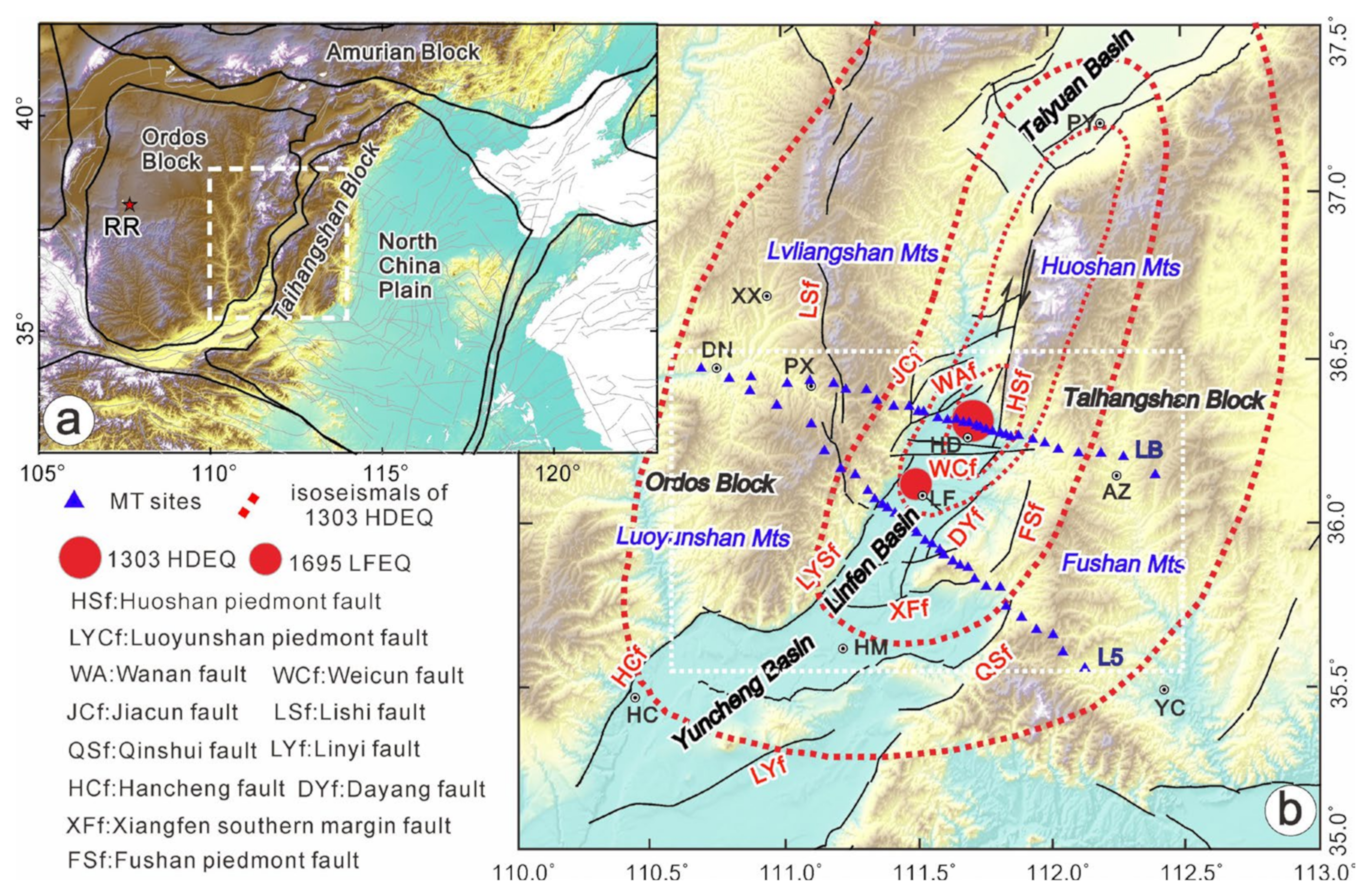
The Shanxi Graben System (SGS), which is located in the western part of North China, is an active tectonic belt. The SGS can be divided into three parts: the southern, central, and northern segments (Figure 1). The kinematics along the SGS are as follows: The central segment exhibits a strike–slip motion, while the northern and southern segments show a northeastward extension [1]. The central segment is mainly composed of north–northeast-trending right-lateral strike–slip faults and the basins whose growth is controlled by these faults. It extends from the Datong Basin in the north through the Yuanping Basin, Taiyuan Basin, and Linfen Basin, and it reaches the Yuncheng Basin in the south (Figure 1). The SGS is also a well-known seismic zone in China that is characterized by frequent and destructive earthquakes with high intensities. Since historical earthquake records have been kept, more than 70 earthquakes with a magnitude of 5 or higher have been recorded within the Shanxi Graben System [2]. The most significant seismic events within the Shanxi Graben System occurred in the central segment, specifically in the Linfen and Hongdong areas, in the years 1303 and 1695, respectively. The 1303 earthquake in Hongdong County, which is located in the northeast of the region, had a magnitude of 8 and was the first M8 earthquake determined by seismologists through the study of historical data [3]. The earthquake was of great magnitude, and its isoseismal lines were distributed in an NNE direction. The epicenter was mainly located in the densely populated Linfen Basin, causing significant economic losses and casualties and leaving behind numerous historical records. Approximately 300 years later, in 1695, another major earthquake with a magnitude of 7¾ occurred in the southern part of the Hongdong seismic zone, near the city of Linfen. The occurrence of two major earthquakes in close proximity within a short period of time is a rare phenomenon in Chinese historical earthquakes.
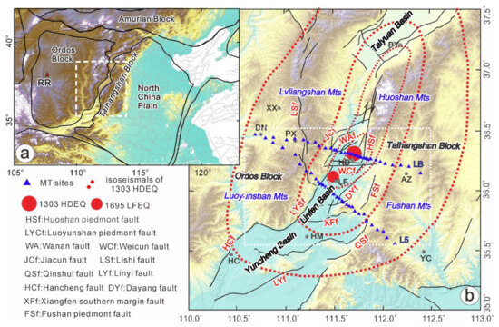
Figure 1.
(a) Tectonic outline map; (b) topography and tectonics of the study area (Deng et al., 2003) and two magnetotelluric profiles (L5 and LB). (XX: Xixian; DN: Daning; PX: Puxian; HD: Hongdong; LF: Linfen; AZ: Anze; YC: Yangcheng; HM: Houma; HC: Hancheng; RR: Remote reference; SGS: Shanxi Graben system; 1303HDEQ: 1303 Hongdong Earthquake; 1695LFEQ: 1695 Linfen Earthquake; RR: Remote reference station.)
Starting from the 1980s, intensive studies were conducted on the structure of the 1303 and 1695 earthquakes and the surrounding areas of the Ordos Block by experts who were primarily led by the research group of the China Earthquake Administration (1988). Among these studies, there is abundant research material available for the 1303 Hongdong earthquake. Early research suggested the presence of an NNE-trending fault within the Linfen Basin as a possible seismogenic structure for the 1303 Hongdong earthquake (Research Group on the Active Fault System around the Ordos Region of the China Earthquake Administration, 1988 [4]). Subsequently, Xu et al., (1990) [5] proposed that the Huoshan Piedmont Fault may be the seismogenic fault for the 1303 Hongdong earthquake, which is similar to the view put forward by Meng et al., (1985) [6] that the Huoshan Piedmont Fault on the eastern side of the Linfen Basin is the seismogenic structure for the 1303 Hongdong earthquake. In the 21st century, research on the 1303 Hongdong earthquake experienced a new surge. Xie et al. (2004) [3] conducted field investigations to determine the Taigu Fault near the Lingshi uplift and discovered that the Taigu Fault may be connected to the Huoshan Piedmont Fault to the south, and both faults exhibit surface rupture zones associated with the 1303 Hongdong earthquake. Jiang et al., (2004) [7] combined the early research on the Huoshan Piedmont Fault by Xu et al., (1990) [4] and the research on the Taigu Fault by Xie et al., (2004) [6] to infer that the surface rupture zone of the 1303 Hongdong earthquake displays a dominant right-lateral strike–slip feature. Xu (2012) [8] speculated that the Huoshan Piedmont Fault serves as the main controlling boundary fault for the Huoshan Mountains and has been relatively active since the Neogene. Later, Xu et al., (2018) [9] conducted a systematic summary study on the Huoshan Piedmont Fault, determining that the primary late Quaternary activity of the fault is characterized by dip–slip motion. Since the Late Pleistocene, four large paleoearthquake events that occurred on the fault have been found through trenching and paleoseismic studies. The research results indicate that the Huoshan Piedmont Fault exhibits strong seismic activity. In comparison, the research on the 1695 Linfen earthquake is relatively recent, and there is relatively less research material available. Wang (1991) [10] initially identified a northwest–southeast-trending fault zone on the northwest side of Linfen as the surface expression of the seismogenic structure for the 1695 Linfen earthquake. Yan et al., (2018) [11] systematically collected and compiled historical seismic damage records for the 1695 Linfen earthquake based on a compilation of Chinese seismic historical data and relevant local chronicles of Linfen and its counties. They determined that the epicenter was located at 36.0°N, 111.5°E and suggested the involvement of the Luoyunshan Piedmont Fault in the occurrence of the earthquake.
The in-depth research results mentioned above indicate that most scholars [4,6,7,8,9] have identified the Huoshan Piedmont Fault as the seismogenic fault for the 1303 Hongdong earthquake. However, there is still uncertainty regarding the seismogenic fault of the 1695 Linfen earthquake. Furthermore, current research methods have primarily focused on seismic geological investigations and trench excavations, utilizing geological methods. There is an urgent need for detailed geophysical exploration of the fault system in the central segment of the Shanxi Graben System, the seismogenic environment of the Hongdong and Linfen earthquakes, and the deep structures of multiple faults within the Linfen Basin. Previous studies by Yin et al., (2016; 2017) [12,13] in the vicinity of the Shanxi Graben System and the Linfen Basin mainly focused on the rheological structure and evolutionary history beneath the basin, with limited discussion on the seismogenic environment. Li et al., (2014) [14] obtained detailed structural information on the southern segment of the Linfen Basin using deep-reflection seismic methods, revealing a pure shear basin model resulting from extensional tectonics. However, the profiles were relatively short and confined to the internal part of the Linfen Basin, and they were unable to explore the large-scale seismogenic deep environment of the Hongdong–Linfen earthquakes. With the increasing seismic activity worldwide, the seismic activity of the Shanxi Graben System, especially that in the central segment, may be entering a new active period. Therefore, it is of great significance to accurately analyze the seismic situation and seismogenic environment in the central segment of the Shanxi Graben System, make comprehensive judgments on future seismic hazards, and contribute to earthquake prediction and mitigation of seismic disasters.
In recent years, with the continuous improvement of numerical computation methods and the application of supercomputing clusters, three-dimensional inversion algorithms for magnetotelluric (MT) data have become increasingly practical and widely used in various MT exploration studies [15,16,17,18,19,20,21]. We conducted two MT profiles crossing the SGS in the central segment and the seismic zones of Hongdong and Linfen (Figure 1). Through qualitative analysis and quantitative inversion calculations, we obtained the electrical structure of the study area, revealing the electrical characteristics of the fault system in the central segment of the Shanxi Graben System and the seismogenic environment of the Hongdong–Linfen earthquakes. In addition to providing a comprehensive interpretation of the seismogenic faults, epicenter locations, focal depths, and seismogenic environments of the 1303 and 1695 earthquakes, the research results can also be further applied to the study of deformation characteristics and deformation mechanisms, as well as the assessment of future strong earthquake hazards in the tectonic belt surrounding the Ordos Block. Furthermore, these findings serve as a basis for engineering construction, seismic mitigation efforts, and medium- to long-term earthquake prediction in the study area, providing valuable insights into deep structural aspects.
2. Background
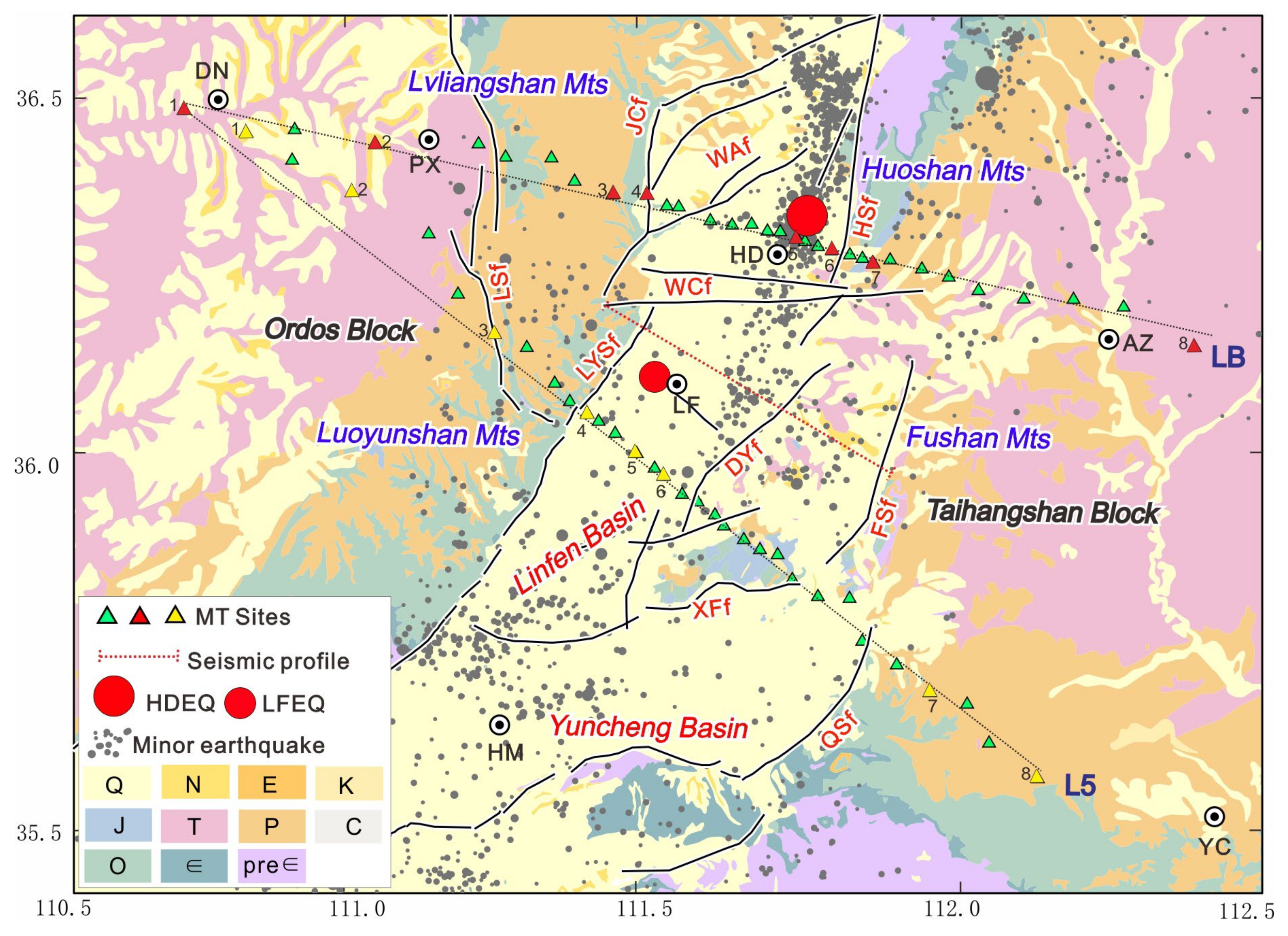
The epicenter locations of the 1303 and 1695 earthquakes are situated within the Linfen Basin, which is part of the central segment of the Shanxi Graben System (Figure 2). The Linfen Basin and its surrounding areas are characterized by complex fault structures. The basin has a general north–northeast trend and is mainly composed of three sub-basins: Houma, Linfen, and Hongdong. These sub-basins are separated by near-east–west-oriented faults. Since the Cenozoic, the region has exhibited significant tectonic subsidence, with the Neogene strata gradually thickening from the mountain front to the basin interior. The maximum sedimentary thickness reaches 2200–2500 m, with the Quaternary reaching up to 800 m, indicating long-term and continuous basin subsidence [1,3].
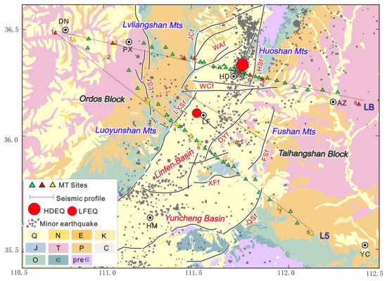
Figure 2.
Geological map of the middle section of the Shanxi Graben System, the magnetotelluric survey sites, and a distribution map of small earthquakes in 2008–2012.
The two magnetotelluric (MT) profiles, LB and L5, are located within the range of 110.5°E to 112.5°E in longitude and 35.5°N to 36.5°N in latitude, as shown in Figure 2. The L5 profile stretches from east of Daning County to Yangcheng, covering a distance of approximately 155 km and consisting of data from 31 MT sites. The LB profile extends from east of Daning County to Anze County, with a length of approximately 160 km and data from 34 MT sites. The L5 profile is close to the area of the 1695 Linfen earthquake, while the LB profile crosses the 1303 Hongdong earthquake area. Both profiles extend southeastward from the Ordos Block, passing through the Linfen Basin and entering the Taihangshan Block. Along the profiles, they traverse secondary blocks such as the Lvliangshan, Luoyunshan, Linfen Basin, Huoshan, and Fushan. The major faults crossed by the profiles include the Huoshan Piedmont Fault (F1), Wan’an Fault (F2), Subu-Weicun Fault (F3), Jiacun Fault (F4), Fushan Piedmont Fault (F5), Lishi Fault (F6), Luoyunshan Piedmont Fault (F7), Qinshui Fault (F8), and Xiangfen Southern Margin Fault (F9). Figure 2 displays the locations of small earthquakes between 2009 and 2018, as determined by precise relocation.
In this area, multiple sets of faults have developed, including north–northeast- or northeast–trending, northwest- or west-trending, and near-east–west-oriented faults. The north–northeast- and northwest-trending faults exhibit the most intense activity. The north–northeast-trending faults are right-lateral strike–slip faults with extensional shear characteristics. They are large in scale and highly active, representing the dominant structures controlling the Linfen Basin. These faults control the basin boundaries and the development of the primary river system, and they include the Huoshan Piedmont Fault (F1) and the Luoyunshan Piedmont Fault (F7). The northwest- or near-east–west-trending faults are dextral faults with smaller scales and younger activity. They are mainly distributed within the basin, intersecting the north–northeast-trending faults and controlling the development of tributaries of the Fen River, and they include the Subu-Weicun Fault (F3) and the Xiangfen Southern Margin Fault (F9).
The new tectonic features of the Linfen Basin mainly manifest as fault activity and differential uplift and subsidence of blocks. The eastern and western sides of the basin are represented by the Huoshan–Fushan uplift zone and the Lvliangshan uplift zone, respectively, both of which are bounded by large-scale active faults. The Subu-Weicun Fault (F3), trending NWW in the northern-central part of the Linfen Basin, divides the basin into two parts (Figure 2). The northern part of the basin is primarily controlled by the Huoshan Piedmont Fault (F1) and exhibits an asymmetric basin morphology, with a deeper eastern part and a shallower western part. The sedimentary center is located near Hongdong. The southern part of the basin is mainly controlled by the Luoyunshan Piedmont Fault (F7) and exhibits a syncline-like basin with deeper western and shallower eastern portions. The sedimentary center is located between Linfen and Ganting [2,3,14].
3. Data Acquisition and Analysis
3.1. MT Data Acquisition
The magnetotelluric (MT) sites are mainly distributed within the interior of the Linfen Basin, which is densely populated and has a high level of industrialization. The MT profiles and their surrounding areas not only traverse multiple coal mines, thermal power plants, and substations, but also intersect with several expressways and electrified railways. As a result, the electromagnetic interference is significant, making data acquisition challenging. The MT data were collected using the MTU-5A instrument from Phoenix Geophysics, Canada. The data for the L5 profile were acquired in November 2019, with each site having an observation time exceeding 40 h. For locations with substantial interference, the observation time exceeded 72 h. In addition, a remote reference station (RR in Figure 1) was installed in Etoke Banner, Inner Mongolia, to facilitate the use of remote reference processing techniques [22,23]. The result was an impedance tensor with a period range of 0.003 to 2000 s. From this, the apparent resistivity, phase data, and tipper were derived for each MT site.
3.2. Qualitative Analysis of the Electrical Structure
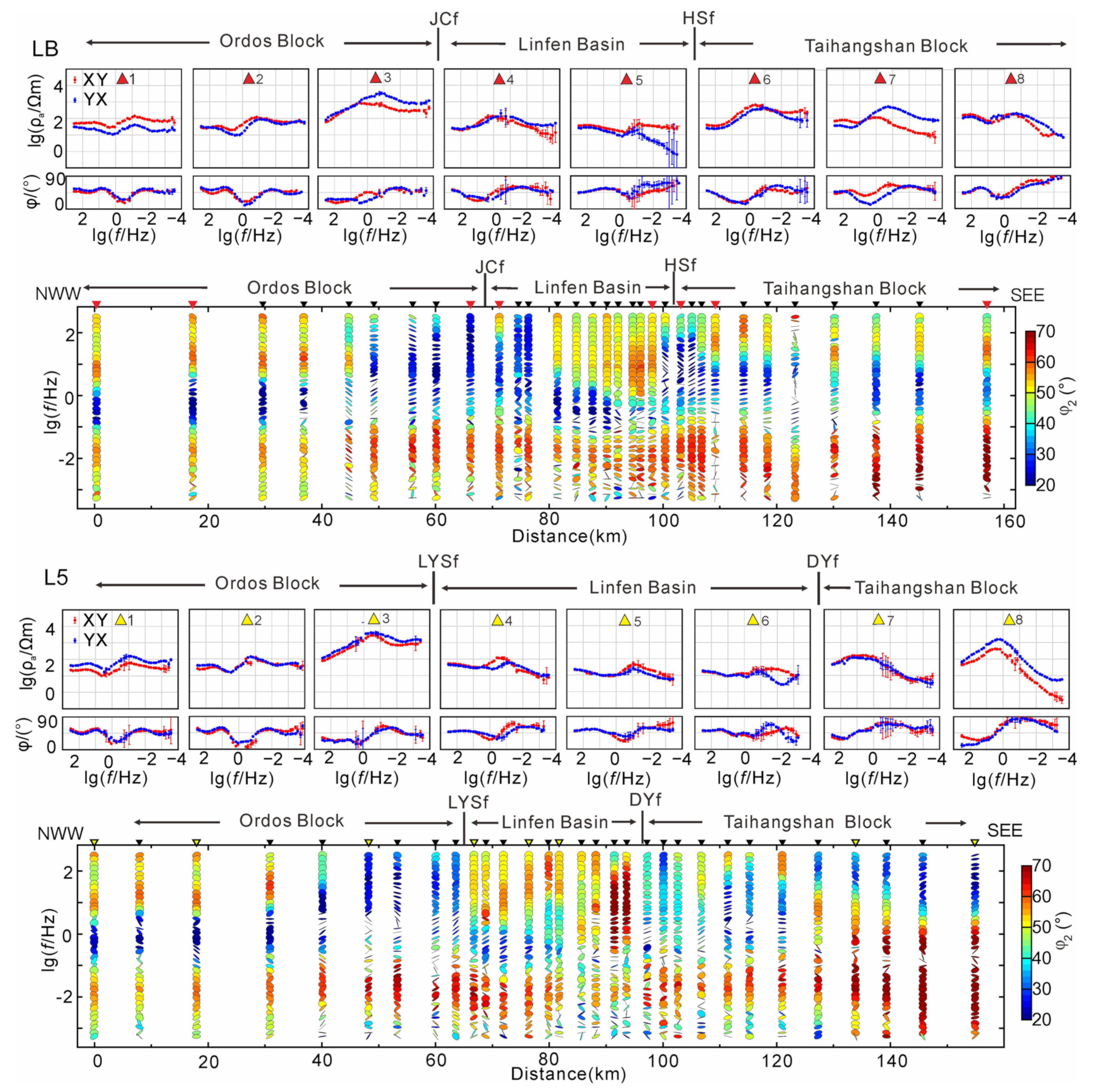
The electrical contrasts within the study area can be identified using the characteristic curves of apparent resistivity and the phase rotation invariant φ2 for each MT station [24,25,26]. A higher value of φ2 indicates that the apparent resistivity decreases with increasing period, while a lower value indicates that the apparent resistivity increases with increasing period. Figure 3 presents the apparent resistivity curves and the distribution of the phase rotation invariant φ2 for eight typical sites located within the three primary tectonic units: the Ordos Block, Linfen Basin, and Taihangshan Block along the two profiles.
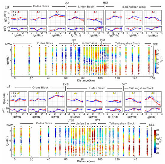
Figure 3.
The phase-tensor data of different periods and apparent resistivity phase curve of typical sites along the LB and L5 profiles.
From Figure 3, it can be observed that the resistivity curves along the two profiles show consistent characteristics. In the stable Ordos Block, the resistivity varies little and remains between 10–100 Ω·m, exhibiting an HK-type curve. The high-frequency and low-frequency resistivity values are invariant, while the mid-frequency resistivity shows slight fluctuations. In the Lvliangshan and Luoyunshan mountain areas, the resistivity curves generally exhibit a K-type pattern with higher resistivity values. The resistivity gradually increases from high to mid frequencies, reaching around 5000 Ω·m, and remains stable at around 1000 Ω·m in the low-frequency range. The Linfen Basin has similar resistivity characteristics to the Ordos Block. In the Taihangshan Block, the resistivity curves generally exhibit a K-type pattern. The high-frequency resistivity remains around 100 Ω·m, and the mid-frequency resistivity is relatively higher but generally does not exceed 1000 Ω·m. The resistivity sharply decreases from mid to low frequencies, reaching as low as 1 Ω·m.
The phase tensor invariant shows a distribution pattern in the Ordos Block where the high-frequency and low-frequency parts are greater than 45°, while the mid-frequency part is less than 45°, indicating a possible stable three-layer structure within the Ordos Block. The typical MT sites along the two profiles also exhibit similar characteristics in terms of apparent resistivity and phase. The MT sites within the Linfen Basin have relatively low apparent resistivity values across the full frequency range. The φ2 values of these points are of a high phase in the higher frequencies above 1 s of a low phase in the frequencies ranging from 1 s to several tens of seconds, and of a high phase beyond several tens of seconds, indicating that the shallow and deep resistivity structures in the Linfen Basin are primarily low-resistivity bodies.
Overall, both profiles show φ2 values greater than 45° in the low-frequency range, particularly beneath the Taihangshan Block on the eastern side of the study area, where the φ2 values exceeding 45° are more pronounced. This suggests there is large volume of low-resistivity structures beneath the Taihangshan Block. The typical MT sites within the Taihangshan Block on the eastern side of the study area also exhibit a significant decrease in apparent resistivity at long periods.
3.3. Dimensionality
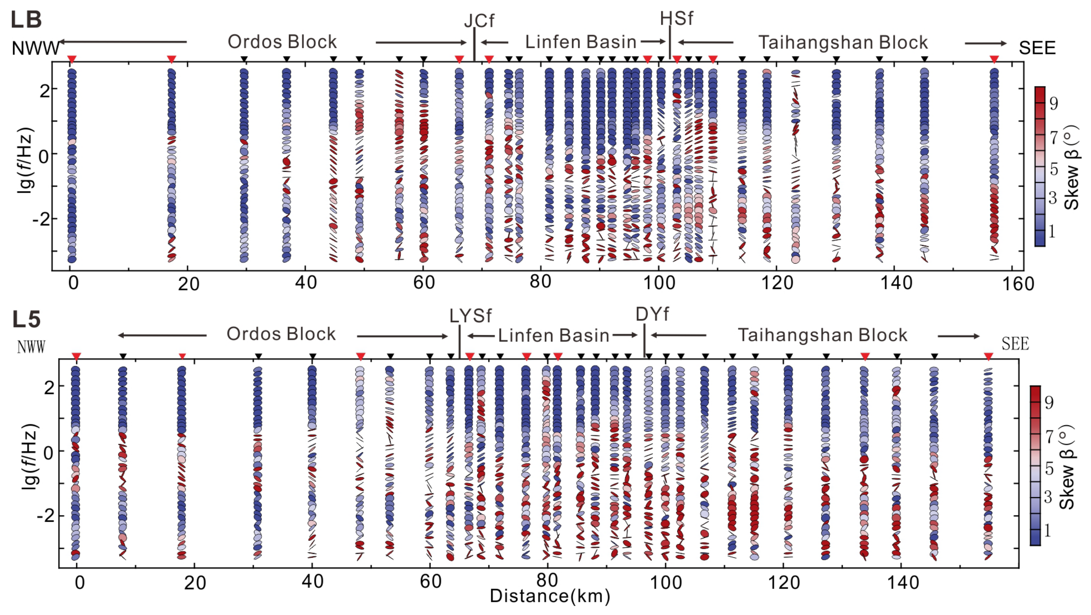
Figure 4 illustrates the distribution of the phase tensor two-dimensional skew |β| of the LB and L5 profiles with respect to the frequency. The two profiles of |β| exhibit consistent overall performance, with most measurement points having |β| values below 3. Particularly in the high-frequency portion of the Linfen Basin, the |β| values are consistently below 3, indicating a uniform electrical structure in the sedimentary layers of the Linfen Basin. However, in the low-frequency portion, there are several cases where the |β| values exceed 3, suggesting a more complex deep structure in the Linfen Basin. This region corresponds to the epicentral location of the 1303 Hongdong earthquake and the 1695 Linfen earthquake, as well as serving as a transition zone between the Ordos Block and the Taihangshan Block. In the Ordos Block, the |β| values are generally below 3, indicating a relatively simple electrical structure in that area. At the location of the Huoshan Piedmont Fault, the two-dimensional deviation |β| reveals significant variations in electrical distribution and complex structural features, indicating the presence of a large-scale fault system in that region.
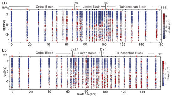
Figure 4.
The |β| phase tensor ellipse of different periods along the LB and L5 profiles.
3.4. Induction Vectors
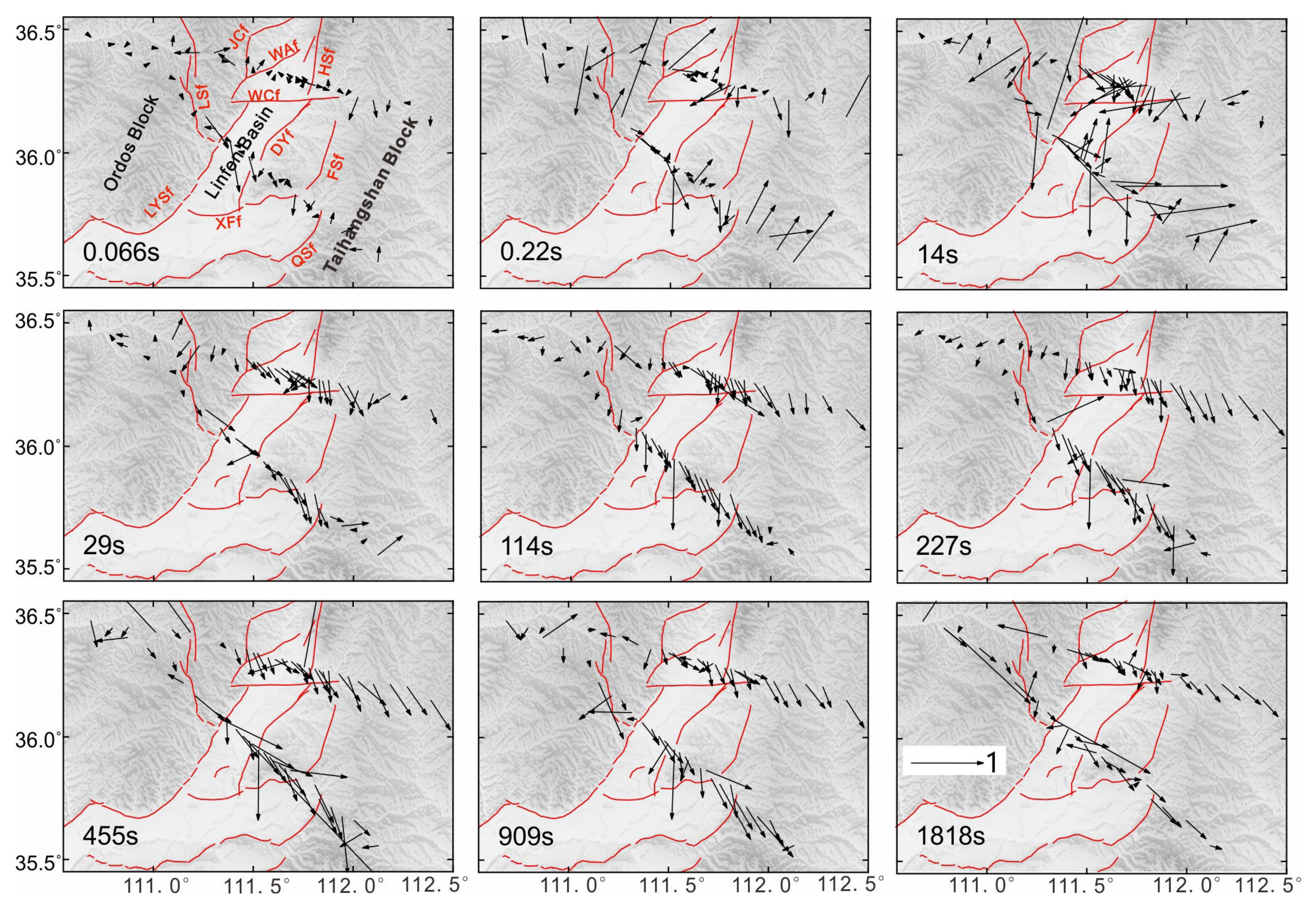
The induction vector is an important parameter used to analyze electrical structures. The real part of the induction vector reflects the lateral heterogeneity of the resistivity distribution in the subsurface, while the magnitude of the vector indicates the magnitude of lateral conductivity variations. The direction of the vector points from high resistivity to low resistivity [27]. Figure 5 presents the distribution of the real parts of induction vectors at nine periods along the two profiles.
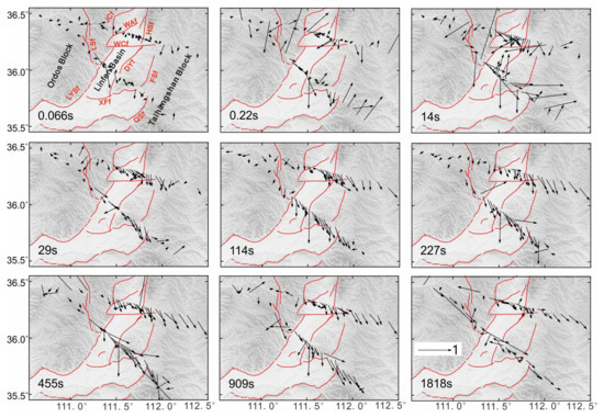
Figure 5.
The Schmucker vectors of different periods in the study area. Red lines denote faults.
From Figure 5, it can be observed that the amplitude of the real induction vectors in the high-frequency portion (0.066 s and 0.22 s) is generally small, and the direction is unclear. This indicates that the induction vectors in the high-frequency range are less affected by lateral heterogeneity, suggesting a uniform shallow electrical structure in the study area, which is primarily composed of widespread loess deposits and Neogene sediments within the Linfen Basin. The amplitude of the real induction vectors below 1.8 s is larger, and the direction is well defined, indicating strong lateral heterogeneity and significant conductivity variations. In terms of tectonic blocks, the overall magnitude of the induction vectors on the western side of the Ordos Block is relatively small and shows little variation, suggesting a relatively stable electrical structure in that region. In the Linfen Basin and Taihangshan Block on the central and eastern sides, the magnitude of the induction vectors is larger in the low-frequency portion, and the direction is well defined but not uniform. This indicates complex deep electrical structures in the region, which is consistent with the results of tectonic analysis. In both the Linfen Basin and Taihangshan Block, the low-frequency portion of the real induction vectors points towards the southeast of the tectonic blocks, and the amplitude is significant, suggesting the possible presence of low-resistivity structures in the deep regions with a tendency to extend southward. Therefore, a detailed three-dimensional inversion of the observed data is necessary to obtain a more reliable electrical structure model.
4. 3D Inversion
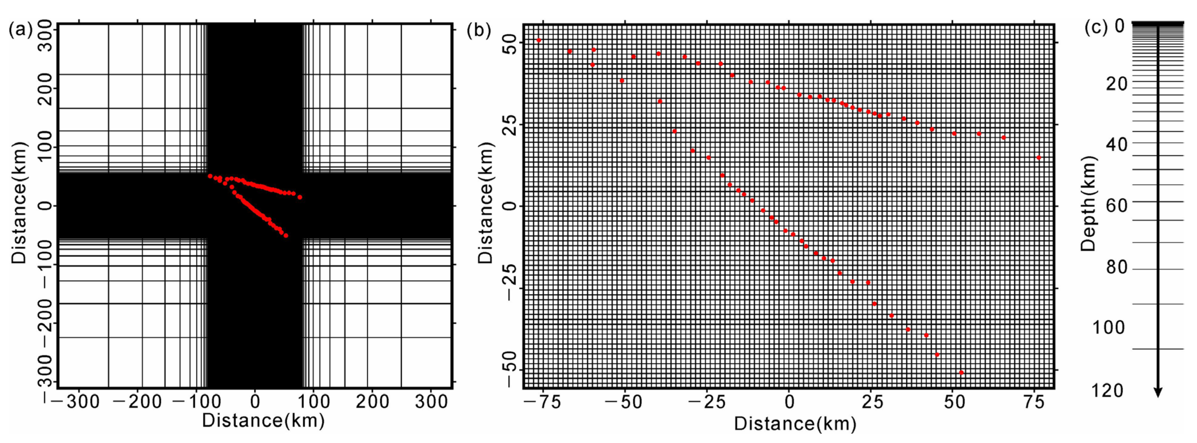
This study employed the ModEM program [15,16] for three-dimensional inversion. As shown in Figure 3 all of the MT sites in the survey area exhibit resistivity values concentrated around 100 Ω·m. Therefore, the initial model has a resistivity of 100 Ω·m. The inversion utilized full tensor impedance data from 63 MT sites, with an error floor of 5% and a period range of 7000 to 0.003 s. The model consisted of a total of 94 × 128 grid cells in the horizontal direction, including a core area of 1.5 km × 1.5 km with 74 × 108 grid cells. In the vertical direction, the first-layer grid thickness was set to 10 m, and the subsequent grid thickness increased. A total of 69 vertical grid cells were defined (Figure 6). The inversion model consisted of a total of 94 × 128 × 69 grid cells. After 72 iterations, the inversion process was completed, and the root-mean-square misfit (RMS) was determined to be 1.75 (Figure 7).
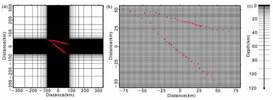
Figure 6.
Model in the 3D inversion. (a) Horizontal grid of the model; (b) horizontal grid of the central part of the model; (c) vertical grid of the model. The red dots denote MT stations.

Figure 7.
The RMS misfit at each station. The ill-posedness of inversion is the main challenge in geophysical data inversion. It exists in all geophysical problems, albeit to varying degrees, and arises from the finite number of observed data (which is generally much smaller than the number of model parameters) and the presence of measurement errors. The MT measurement data in the survey area consist of 63 (MT sites) × 40 (frequencies) × 4 = 10,080 data points, while the three-dimensional inversion model consists of 94 × 128 × 77 = 926,464 grid cells, indicating a significant non-uniqueness in the inversion process. Red lines denote faults.
Regularized inversion can partially alleviate the ill-posedness of inversion. It seeks the best model that fits the data while also satisfying certain constraints (such as the smoothest model). However, regularized inversion introduces potentially redundant structures into the model while reducing the ill-posedness of the inversion. Therefore, it is necessary to assess the reliability of the electrical structure obtained from the inversion. Currently, there are two main methods used for evaluating the reliability of inversion results [28,29].
- (1)
- Forward validation: Some structures are removed from the resulting model (by modifying the resistivity values), and then forward calculation is performed. The difference between the responses of the modified model and the original model is assessed. If there is a significant difference, this indicates that the removed structure is constrained by the observed data and, therefore, considered reliable. Conversely, if there is no significant difference, the removed structure is considered unreliable.
- (2)
- Constraint inversion: Some structures in the inversion result model are fixed (kept unchanged during the inversion process), and then inversion is performed until convergence. The change in the fit and the change in the model are observed. If the fit error of the inverted model is larger than that of the original model, this indicates that the fixed structure is reliable. However, constraint inversion is challenging due to the strong non-uniqueness of MT inversion.
In this study, the forward validation method was employed to assess the main characteristics of the inversion results. The resistivity values of key electrical structures were modified to create corresponding modified models, and the differences between the responses of the modified models and the original response were calculated through three-dimensional forward modeling. Qualitative comparisons were made between the response curves of the original model and the perturbed models.
Seven representative electrical structures (C1–C6 and R1) were selected from the three tectonic units in the survey area. The resistivity values of these structures were individually modified to different values (30 Ω·m, 100 Ω·m, 300 Ω·m, 1000 Ω·m, and 3000 Ω·m), and three-dimensional forward modeling was performed for the modified models to obtain the theoretical response curves of the modified models. The curves of the typical MT sites in the modified models deviated significantly from the observed response curves, particularly starting from high frequencies (see Figures S4–S6). These results indicate that the seven representative electrical structures are constrained by the observed data and are considered reliable in the final model.
5. Results and Discussions
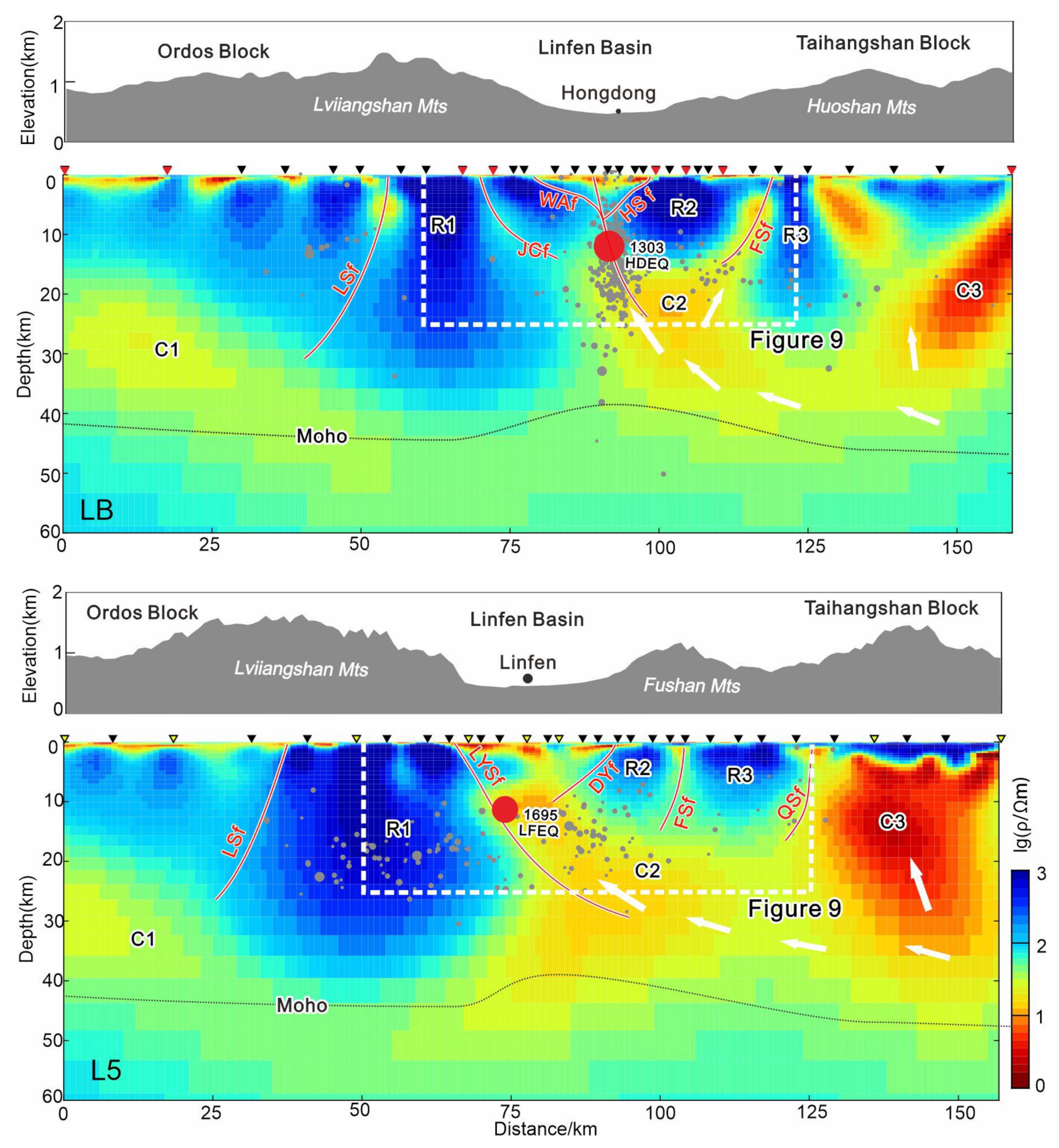
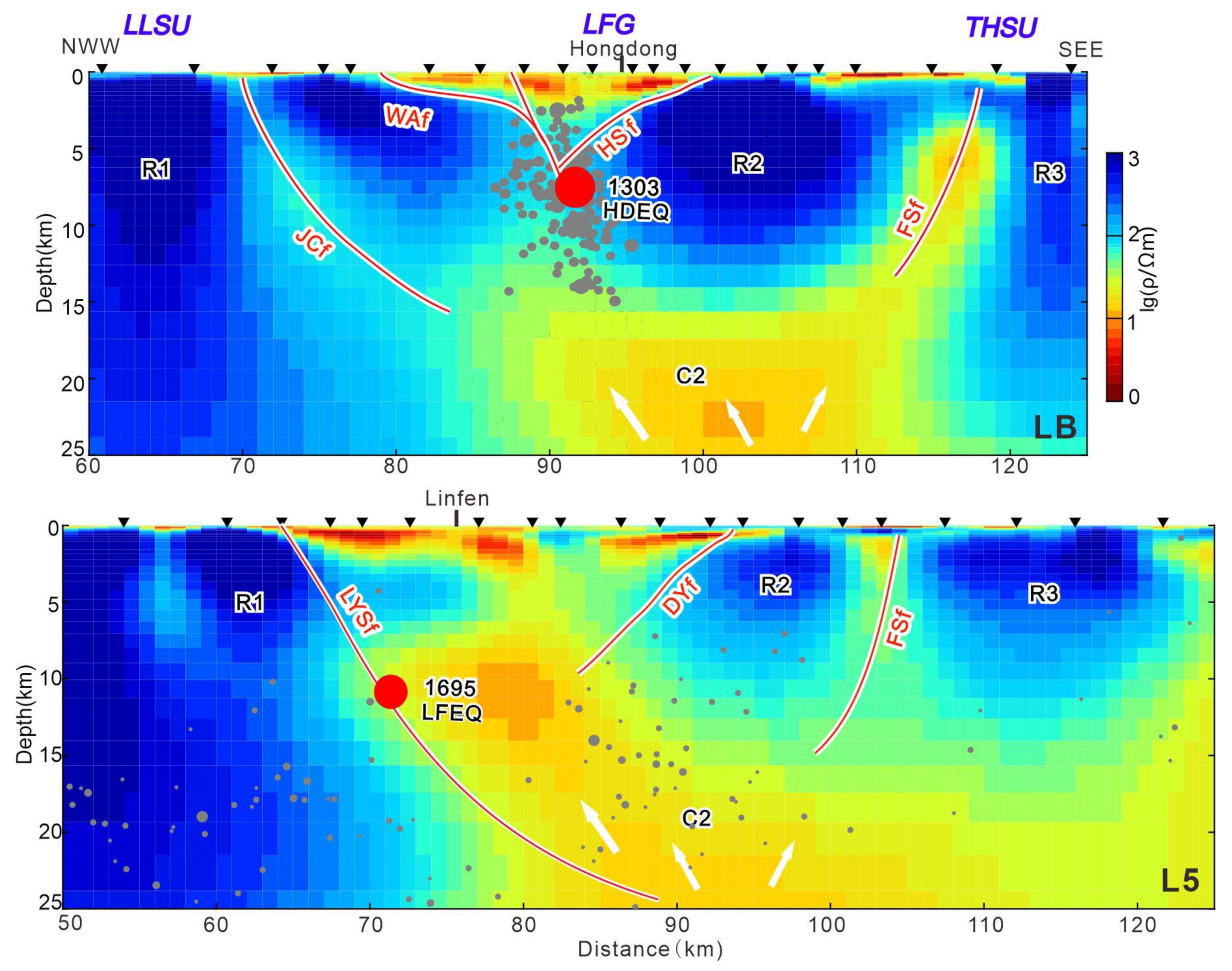
Figure 8 presents the electrical structure profiles obtained from the three-dimensional inversion, while Figure 9 displays the electrical structure maps of the core regions along the two profiles. As shown in the figures, different distributions of high- and low-resistivity bodies are observed along the two profiles, with high-resistivity bodies being labeled as “R” and low-resistivity bodies being labeled as “C”. The results of precise hypocenter locations of small earthquakes between 2009 and 2018 in the vicinity of the LB profile were vertically projected onto the electrical structure maps. The Moho obtained from seismology near the profiles is also shown on the electrical structure maps [14]. Additionally, the topographic distribution of the study area and the surface traces of major faults are depicted on the electrical structure maps.
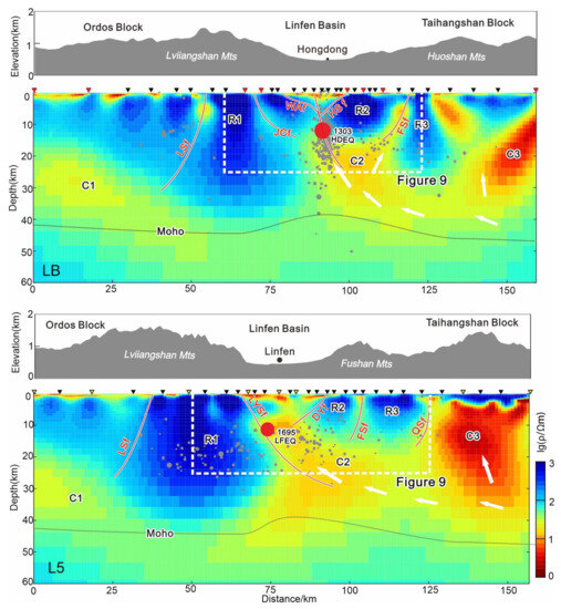
Figure 8.
Deep electrical structures and interpretations of the profiles. The Moho was from Li et al., (2014) [14]. White arrows denote the movement of wet and hot materials.
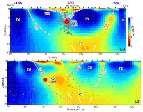
Figure 9.
Deep electrical structures and interpretations of the profiles.
As depicted in Figure 8, the electrical structure characteristics along the two profiles show overall similarity. There are distinct lateral variations corresponding to different tectonic blocks, and prominent fault systems are often associated with regions of significant electrical contrast. We will discuss the electrical structure characteristics and fault distributions of each tectonic block in the study area separately.
5.1. Electrical Resistivity of Major Structures
The western part of the study area, corresponding to the Ordos Block, exhibits a relatively simple electrical structure characterized by a high–low–high-resistivity three-layer structure. The upper crust is a relatively homogeneous high-resistivity layer, and the deeper parts of the Ordos Block show a trend of increasing resistivity towards the east. Extensive occurrences of mid- to low-resistivity structures (C1) are observed in the mid-lower crust of the Ordos Block, while the structure below the Moho discontinuity is characterized by medium to high resistivity. These results are similar to those of previous studies [30,31,32,33], which indicated that the Ordos Block is a relatively intact rigid block with limited deep roots. The presence of widespread low-velocity, low-resistivity materials in the mid-lower crust beneath the Ordos Block has been supported by seismic studies [34], suggesting a lack of large-scale destructive activities in the Ordos Block. Similar layer-like electrical structures characterized by high–low–high-resistivity distributions have also been observed in the Songpan-Ganzi Block and Alxa Block [35,36,37,38], indicating relatively stable tectonic environments.
In contrast, the LB and L5 profiles reveal that the Linfen Basin exhibits a trend of mid-to low-resistivity (C2) distribution from shallow to deep. Along the LB profile in the northern region, the mid- to low-resistivity structure has a relatively small scale. However, along the L5 profile in the southern region, the mid- to low-resistivity layer is more extensive and deeper, showing distinct distribution characteristics different from those of the western Ordos Block. Various geophysical methods [34,39] have revealed the presence of a prominent low-velocity, low-resistivity layer in the depth range of 10–30 km in the Linfen Basin, which may form a “multi-seismic layer” or “seismogenic layer.” Furthermore, seismic data [14] have indicated a significant upward-arching feature of the Moho discontinuity in the Linfen Basin, suggesting a marked difference in structure between the Linfen Basin and the surrounding eastern and western blocks, which is consistent with the MT results in this study. In the eastern part of the Linfen Basin, corresponding to the Taihangshan Block, the upper crust exhibits a distinct high–low-resistivity fragmentation zone, and the mid-lower crust consists of low-resistivity structures (C3) that extend into the mantle. Similarly to the Linfen Basin, the scale of the low-resistivity bodies in the southern region traversed by the L5 profile is larger, with lower resistivity values. These low-resistivity bodies are interconnected with the mid- to low-resistivity structures in the mid-lower crust beneath the Linfen Basin, suggesting a continuation of low-resistivity structures towards the east. Xu et al. (2018) [9] speculated about the occurrence of upper-mantle upwelling near the Linfen Basin, which is consistent with the earlier findings of Yin et al., (2016) [12] from MT exploration. The discovery of large-scale low-resistivity bodies in the eastern region of the Linfen Basin provides further geophysical evidence for these hypotheses. These observations indicate that, compared to the stable Ordos Block, the Taihangshan Block has undergone significant lithospheric destruction and exhibits crustal thinning tendencies.
5.2. Fault Structures Controlled by Linfen Basin
From electrical structures of the LB and L5 profiles, it can be observed that the Linfen Basin, located in the middle section of the Shanxi Graben System, serves as a transitional zone separating the Ordos Block and the Taihangshan Block. The Huoshan Piedmont Fault, which forms the eastern boundary of the Linfen Basin, is a controlling fault in the study area. The electrical structures on both sides of this fault, corresponding to the Ordos Block and the North China Craton, exhibit distinct differences. This suggests that the Huoshan Piedmont Fault may serve as the basement fault dividing the Ordos Block and the Taihangshan Block. This fault extends throughout the entire crust, from the surface to a depth of 40 km or even crossing the Moho discontinuity, consistently with the insights obtained from the phase tensor skew and invariant in Figure 3 and Figure 4. When considering the planar distribution of small earthquake locations between 2009 and 2018, as shown in Figure 1, it is likely that the Huoshan Piedmont Fault predominantly strikes in an NNE direction. The electrical structure maps also reveal that the Huoshan Piedmont Fault exhibits a distribution feature with a high-angle northwestward trend. Li et al., (2014) [14] revealed a large-scale planar normal fault system within the Linfen Basin through deep seismic reflection profiles, which, when combined with the MT results in this study, suggests that the main fault of this planar normal fault system is the Huoshan Piedmont Fault. By vertically projecting the results of precise hypocenter determination for small earthquakes between January 2008 and December 2012 onto the electrical structure map of the LB profile, it is found that the small earthquakes are concentrated near the mid- to low-resistivity zone beneath the Huoshan Piedmont Fault, similarly to the findings of Hu et al., (2002) [39] regarding the focal mechanism solutions and three-dimensional spatial distribution of earthquake hypocenters in the Linfen Basin from 1987 to 1999. This observation is also consistent with the conclusion drawn from the MT results in the Menyuan earthquake area in 2016, which identified seismic activity occurring within low-resistivity bodies formed by fault zones [40]. Figure 8 displays the dense distribution of small earthquakes in the depth range of 10–20 km, which is close to the depth of the low-resistivity body formed by the Huoshan Piedmont Fault. It is inferred that the 1303 Hongdong earthquake may have occurred within the low-resistivity body beneath the Huoshan Piedmont Fault, with an estimated earthquake source depth ranging from 10 to 20 km. The existence of such a low-resistivity body creates an obvious mechanically weak zone, leading to the occurrence of the 1303 Hongdong earthquake. The above analysis indicates that the MT results, combined with the distribution characteristics of small earthquakes, support the conjecture that the seismogenic fault for the 1303 Hongdong earthquake is the Huoshan Piedmont Fault, as proposed by the geological surveys [4,6,7,8,9].
Regarding the LB and L5 profiles, the electrical structure demonstrates that the Luoyunshan Piedmont Fault is the western boundary fault of the Linfen Basin. Along the L5 profile in the southern region of the study area, the Luoyunshan Piedmont Fault exhibits a larger scale, possibly forming a positive fault system together with the Huoshan Piedmont Fault within the Linfen Basin. The research conducted by Xu et al. (2018) [9] indicates that the motion component of the Huoshan Piedmont Fault gradually transitions to the Luoyunshan Piedmont Fault in the southern part of the study area. Additionally, the results of precise hypocenter determination for small earthquakes between 2009 and 2018 also suggest that the Huoshan Piedmont Fault gradually disappears southward, and seismic activity presents a scattered distribution near the L5 profile. These observations are consistent with the results of the present MT. Therefore, it is inferred that the Luoyunshan Piedmont Fault in the southern part of the Linfen Basin is likely the main fault system in this region. Currently, the understanding of the seismogenic fault for the 1695 Linfen earthquake is relatively limited. The latest research by Yan et al., (2018) [11] suggests that multiple faults, including the Luoyunshan Piedmont Fault, participated in the 1695 Linfen earthquake within the Linfen Basin. Xu et al., (2011) [41] proposed that the Luoyunshan Piedmont Fault exhibited intense activity during the Holocene and may have played a dominant role in the occurrence of the 1695 Linfen earthquake. The MT results provide geophysical evidence for these research findings, supporting the notion that the Luoyunshan Piedmont Fault is a major fault system within the Linfen Basin with the potential to generate large earthquakes. Furthermore, the Fushan Piedmont Fault (F5) and Lishi Fault (F6) also exhibit electrical boundary features, with the Lishi Fault possibly being a larger fault system in the study area. These observations align with the results obtained from MT profiles in the northern part of the study area reported by Zhao et al. (2010) [31]. The possible extension features of these faults have been illustrated in the electrical structure maps.
5.3. Seismogenic Structures and Mechanisms of the Hongdong and Linfen Earthquakes
To explore the mechanisms of large earthquakes, it is necessary to consider the regional tectonic movements. The Huoshan Piedmont Fault, located near the occurrence of the 1303 Hongdong earthquake, is situated at the eastern boundary of the Linfen Basin in the middle section of the Shanxi rift system, which is on the southeastern margin of the Ordos Block. The Luoyunshan Piedmont Fault, where the 1695 Linfen earthquake possibly occurred, is positioned at the western boundary of the Linfen Basin within the middle section of the Shanxi rift system. In the periphery of the Ordos Block, apart from the southwestern corner being subjected to the northeastward compression from the Tibetan Plateau, the rest of the area consists of graben basins. The Linfen Basin in the middle section of the Shanxi rift system is the most typical graben basin.
Currently, various models have been proposed for the formation of the Linfen Basin. The main hypotheses suggest that it was formed due to the overall counterclockwise motion of the Ordos Block [42,43,44] and the extension caused by the upwelling of asthenospheric material (Xu et al., 2018). Hao et al., (2016) [43] found that the Ordos Block exhibits an overall slow uplift trend (uplift rates ranging from 0.6 to 2.6 mm/year), while the vicinity of the Linfen Basin experiences subsidence at a rate of 2–3 mm/year. Chen et al. (2011) [42] verified the overall horizontal movement of the Ordos Block through the GPS velocity field, indicating a counterclockwise rotational trend [44].
Previous studies [30,31,32,33,34] have indicated that the Ordos Block is a relatively rigid block with shallow roots. Combining the findings of Hao et al., (2016) [43], Chen et al., (2011) [42], Zhang et al., (2018) [44], and others regarding the deformation field, it is inferred that the Ordos Block may undergo an overall counterclockwise rotational and uplifting motion due to the northeastward compression from the Tibetan Plateau. This motion has resulted in the formation of the Huoshan Piedmont Fault and Luoyunshan Piedmont Fault near the eastern edge of the Linfen Basin, exhibiting a pronounced right-lateral strike–slip movement. The Huoshan Piedmont Fault and Luoyunshan Piedmont Fault exhibit a dominant right-lateral strike–slip movement [4,6,7].
The recent study by Xu et al., (2018) [9] suggested that the Huoshan Piedmont Fault exhibits both strike–slip and reverse dip–slip motion. The fault formation may be directly related to regional extension in the Taihangshan Block. It is suggested that the activity of the Huoshan Piedmont Fault and Luoyunshan Piedmont Fault is primarily controlled by the upwelling of material from the lower crustal area, resulting in recurrent reverse dip–slip motion. The detection results indicate that the mid-lower crust of the Taihangshan Block on the eastern side of the Linfen Basin consists of large-scale low-resistivity structures. These low-resistivity structures and the lower crustal low-resistivity zone beneath the Linfen Basin are connected. The low-resistivity structures in the mid-lower crust of the Taihangshan Block may serve as pathways for asthenospheric fluids, extending through the Huoshan Piedmont Fault and reaching beneath the Linfen Basin. This leads to the recurrent reverse dip–slip motion dominated by the upwelling and movement of lower crustal material, providing further support for the inference made by Xu et al., (2018) [9].
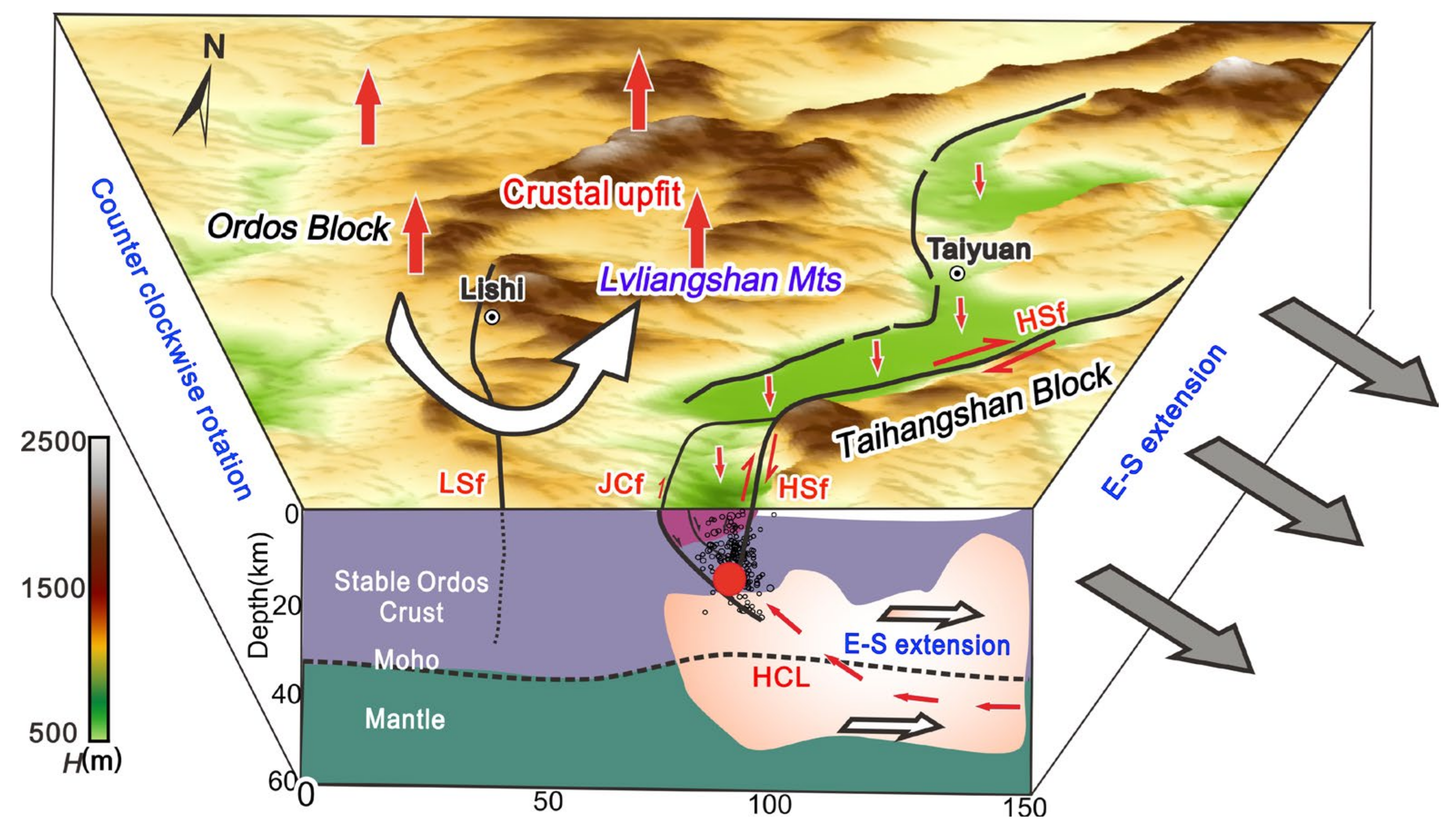
Li et al., (2014) [14] revealed the upward arching of the Moho interface in the lower part of the Linfen Basin using seismic methods, along with a higher heat flow value beneath the basin, suggesting possible thermal upwelling. This finding is consistent with the results of the current MT study. Considering the comprehensive analysis of the deformation field [42,43,44], recent geological studies [9], and geophysical investigations [14,30,31,32,33,34,45], it is suggested that the macro-scale seismic environments of the 1303 Hongdong earthquake and the 1695 Linfen earthquake may be similar. As shown in Figure 10, these earthquakes were influenced by multiple factors. In addition to the northeastward compression from the Tibetan Plateau, the Ordos Block may undergo overall counterclockwise motion and uplift, resulting in the significant right-lateral strike–slip motion of the Huoshan Piedmont Fault and Luoyunshan Piedmont Fault near the Linfen Basin. Furthermore, the upwelling of asthenospheric material in the mid-lower crust on the eastern side of the Linfen Basin induced by regional extension in the Taihangshan Block may contribute to the reverse dip–slip motion of the Huoshan Piedmont Fault and Luoyunshan Piedmont Fault, which played a major role in the occurrence of the earthquakes.
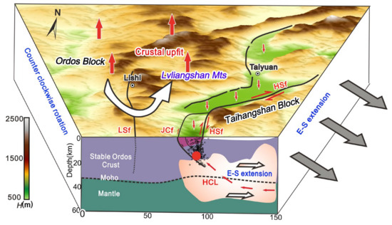
Figure 10.
A picture of the tectonic movement mode in the middle section of the Shanxi Graben System (the white arrow indicates the direction of the regional stress field).
6. Conclusions
In this study, we conducted qualitative analysis and inversion calculations of MT data collected from 65 MT sites along two profiles using 3D NLCG inversion methods. The results were further integrated with regional deformation patterns, recent seismic and geological investigations, and high-precision earthquake location data between January 2008 and December 2012. Based on these comprehensive analyses, the following conclusions were drawn.
- (1)
- The MT survey revealed that the Huoshan and Luoyunshan Piedmont faults are the main fault systems in the middle section of the Shanxi Graben. These faults span the entire crust and serve as the basement faults dividing the Ordos and Taihangshan Blocks. Notably, the western part of the Shanxi Graben corresponds to the stable Ordos block, while the eastern part, corresponding to the Taihangshan Block, shows significant lithospheric destruction and thinning trends.
- (2)
- The MT results confirmed that the seismogenic fault of the 1303 Hongdong earthquake was the Huoshan Piedmont Fault. It is speculated that the earthquake occurred within the low-resistivity zone associated with the Huoshan Piedmont Fault. Additionally, these findings provide geophysical evidence supporting the dominance of the Luoyunshan Piedmont Fault in the occurrence of the 1695 Linfen earthquake.
- (3)
- The seismic environments of the 1303 Hongdong earthquake and the 1695 Linfen earthquake were influenced by multiple factors. The upwelling of asthenospheric material in the middle-lower crust of the eastern part of the Linfen Basin induced regional extension in the North China Block. This extensional environment likely contributed to the occurrence of the dominant strike–slip movements along the Huoshan and Luoyunshan Piedmont Faults.
Supplementary Materials
The following supporting information can be downloaded at: https://www.mdpi.com/article/10.3390/rs15194792/s1, Figure S1: Comparisons of the MT responses in the study region without and with remote-reference processing. (a) Locations of the study region and remote reference station (RR); (b) MT responses without remote-reference processing. (c) MT responses with remote-reference processing, Figure S2: Fitted curve for inversion of LB profile measurement points (Zxy, Zyx directions), Figure S3: Fitted curve for inversion of measured points in profile L5 (Zxx, Zyy directions), Figure S4: R1 orthogonal curve fit, Figure S5: C1–C6 orthogonal curve fit, Figure S6: diagram of the orthogonal range.
Author Contributions
Conceptualization, X.X. and Y.Z.; methodology, Y.Z.; software, L.Z.; validation, X.X., Y.Z. and L.Z.; formal analysis, Y.Z.; investigation, S.P.; resources, X.X.; data curation, Y.Z.; writing—original draft preparation, X.X. and Y.Z.; writing—review and editing, X.X., Y.Z. and S.P.; visualization, L.Z.; supervision, Y.Z.; project administration, Y.Z.; funding acquisition, X.X. All authors have read and agreed to the published version of the manuscript.
Funding
This research was funded by the National Key Research and Development Program of China (2017YFC1500103), the National Field Scientific Observation and Research Station Project of Continental Rift Dynamics in Taiyuan, Shanxi Province (NORSTY 20-07), and the National Natural Science Foundation of China (42274103), as well as the CNPC Science and Technology Academic Project (RIPED.CN-2023-JS-187).
Data Availability Statement
Data will be made available on request.
Conflicts of Interest
The authors declare no conflict of interest.
References
- Xu, X.; Deng, Q.; Dong, R.; Zhang, C.; Cao, W. Study on strong earthquake activity and risk areas in the Shanxi graben system, seismology and geology. Seismol. Geol. 1992, 4, 305–316. [Google Scholar]
- Deng, Q.; Zhang, P.; RAN, Y. Active tectonics and earthquake activities in China. Earth Sci. Front. 2003, 10, 66–73. [Google Scholar]
- Xie, X.; Jiang, W.; Wang, H. Holocene activities of the Taigu fault zone, Shanxi province, in relation to the 1303 Hongdong M=8 earthquake. Acta Seismol. Sin. 2004, 26, 281–293. [Google Scholar] [CrossRef]
- The Research Group on “Active Fault System around Orods Massif”, State Seismological Bureau. Active Fault System around Massif; Seismological Press: Beijing, China, 1988. (In Chinese) [Google Scholar]
- Xu, X.; Deng, Q. The features of Late Quaternary activity of the piedmont fault of Huoshan Shanxi province and 1303 Hongdong earthquake. Geophys. Geochem. Explor. 1990, 12, 21–30. [Google Scholar]
- Meng, X.; Yu, S.; Xi, Y. The investigations of deformation traces of the Ms=8.0 earthquake in Hongdong, Shanxi province. Seismol. Geol. 1985, 7, 1–10. [Google Scholar]
- Jiang, W.; Deng, Q.; Xu, X. Structure rupture zone of the 1303 Hongdong M=8 earthquake, Shanxi province. Acta Seismol. Sin. 2004, 26, 355–362. [Google Scholar]
- Xu, Y. A Study on the Late Quaternary Faulting of the Huoshan Piedmont Fault Zone in the Central Shanxi Faulted Basin Belt; Institute of Geology, China Earthquake Administration: Beijing, China, 2012. (In Chinese) [Google Scholar]
- Xu, Y.; He, H.; Deng, Q. The CE 1303 Hongdong earthquake and the Huoshan Piedmont Fault, Shanxi Graben: Implications for magnitude limits of normal fault earthquakes. J. Geophys. Res. 2018, 123, 3098–3121. [Google Scholar] [CrossRef]
- Wang, T.; Li, X.; Zheng, B. Newly Discovered Geological evidences for the seismogenic structure of 1695 strong earthquake in Linfen, Shanxi province, China. Seismol. Geol. 1991, 1, 26–27. [Google Scholar]
- Yan, X.; Zhou, Y.; Li, Z. A Study on the seismogenic structure of Linfen M7 4/3 earthquake in 1695. Seismol. Geol. 2018, 40, 883–902. [Google Scholar]
- Yin, Y.; Jin, S.; Wei, W. Construction and destruction of the North China Craton with implications for metallogeny: Magnetotelluric evidence from the Hengshan–Wutai–Fuping region within Trans-North China Orogen. Gondwana Res. 2016, 40, 21–42. [Google Scholar] [CrossRef]
- Yin, Y.; Wei, W.; Jin, S. Fossil oceanic subduction zone beneath the western margin of the Trans-North China Orogen: Magnetotelluric evidence from the Lüliang Complex. Precambrian Res. 2017, 303, 54–74. [Google Scholar] [CrossRef]
- Li, Z.; Liu, B.; Yuan, H. Fine crustal structure and tectonics of Linfen Basin-from the results of seismic reflect profile. Chin. J. Geophys. 2014, 57, 1487–1497. [Google Scholar]
- Egbert, G.D.A.; Kelbert, A. Computational recipes for electromagnetic inverse problems. Geophys. J. Int. 2012, 189, 251–267. [Google Scholar] [CrossRef]
- Kelbert, A.; Meqbel, N.; Egbert, G.D.; Tandon, K. ModEM: A modular system for inversion of electromagnetic geophysical data. Comput. Geosci. 2014, 66, 40–53. [Google Scholar] [CrossRef]
- Dong, H.; Wei, W.; Ye, G.; Jin, S.; Jones, A.G.; Jing, J.; Zhang, L.; Xie, C.; Zhang, F.; Wang, H. Three-dimensional electrical structure of the crust and upper mantle in Ordos block and adjacent area: Evidence of regional lithospheric modification. Geochem. Geophys. Geosyst. 2014, 15, 2414–2425. [Google Scholar] [CrossRef]
- Lin, C.; Peng, M.; Tan, H.; Xu, Z.; Li, Z.H.; Kong, W.; Tong, T.; Wang, M.; Zeng, W. Crustal structure beneath Namche Barwa, eastern Himalayan syntaxis: New insights from three-dimensional magnetotelluric imaging. J. Geophys. Res.-Solid. Earth 2017, 122, 5082–5100. [Google Scholar] [CrossRef]
- Cai, J.; Chen, X.; Xu, X.; Tang, J.; Wang, L.; Guo, C. Rupture mechanism and seismotectonics of the Ms6.5 Ludian earthquake inferred from three-dimensional magnetotelluric imaging. Geophys. Res. Lett. 2017, 44, 1275–1285. [Google Scholar] [CrossRef]
- Wang, X.B.; Zhang, G.; Zhou, J.; Li, D.W.; Luo, W.; Hu, Y.B.; Cai, X.L.; Guo, Z.M. Crust and upper mantle electrical resistivity structure in the Longmenshan tectonic belt and its relationship with Wenchuan and Lushan earthquake. Chin. J Geophys. 2018, 61, 1984–1995. (In Chinese) [Google Scholar]
- Hu, X.; Lin, W.; Yang, W.; Yang, B. A review of developments in the electrical structure of craton lithosphere. Sci. China Earth Sci. 2020, 63, 1661–1677. [Google Scholar] [CrossRef]
- Egbert, G.; Booker, J.R. Robust estimation of geomagnetic transfer functions. Geophys. Res. 1986, 87, 173–194. [Google Scholar] [CrossRef]
- Chave, A.D.; Thomson, D.J.; Ander, M.E. On the robust estimation of power spectra, coherences and transfer functions. Geophys. Res. 1987, 92, 633–648. [Google Scholar] [CrossRef]
- Caldwell, T.G.; Bibbly, H.M.; Brown, C. The magnetotelluric phase tensor. Geophys. J. Int. 2004, 158, 457–469. [Google Scholar] [CrossRef]
- Bibby, H.M.; Caldwell, T.G.; Brown, C. Determinable and non-determinable parameters of galvanic distortion in magnetotellurics. Geophys. J. Int. 2005, 163, 915–930. [Google Scholar] [CrossRef]
- Heise, W.; Caldwell, T.G.; Bibby, H.M. Three-dimensional modeling of magnetotelluric data from the Rotokawa geothermal field, Taupo Volcanic Zone, New Zealand. Geophys. J. Int. 2008, 173, 740–750. [Google Scholar] [CrossRef]
- Parkinson, W.D. The influence of continents and oceans on geomagnetic variations. Geophys. J. Int. 1962, 6, 441–449. [Google Scholar] [CrossRef]
- Worzewski, T.; Jegen, M.; Kopp, H. Magnetotelluric image of the fluid cycle in the Costa Rican subduction zone. Nat. Geosci. 2011, 4, 108–111. [Google Scholar] [CrossRef]
- Becken, M.; Ritter, O.; Bedrosian, P.A. Correlation between deep fluids, tremor and creep along the central San Andreas fault. Nature 2011, 480, 87–90. [Google Scholar] [CrossRef] [PubMed]
- Tang, J.; Zhan, Y.; Zhao, G. Electrical structure of the crust and upper mantle in Maqin Lanzhou Jingbian section, northeastern margin of Qinghai Tibet Plateau. Chin. J. Geophys. 2005, 48, 1205–1216. [Google Scholar] [CrossRef]
- Zhao, G.; Zhan, Y.; Wang, L. Electric structure of the crust beneath the ordos fault block. Seismol. Geol. 2010, 32, 345–359. [Google Scholar]
- Li, C.; Bai, D.; Xue, S. A magnetotelluric study of the deep electric structure beneath the Ordos Block. Chin. J. Geophys. 2017, 60, 1788–1799. [Google Scholar]
- Xu, L.; Wei, W.; Jin, S. Study of deep electrical structure along a profile from northern Ordos block to Yinshan orogenic belt. Chin. J. Geophys. 2017, 60, 575–584. [Google Scholar]
- Chen, Z.; Wang, C.; Lou, H. Crust and upper mantle velocity structure beneath the Ordos Block and its tectonic significance. Chin. Sci. Bull. 2018, 63, 327–339. [Google Scholar] [CrossRef]
- Wang, X.; Zhan, Y.; Zhao, G. Deep electric structure beneath the northern section of the western margin of the Ordos basin. Chin. J. Geophys. 2010, 50, 595–604. [Google Scholar]
- Zhan, Y.; Zhao, G.; Martyn, U. Deep structure beneath the southwestern section of the Longmenshan fault zone and seismogenic context of the 4.20 MS7.0 earthquake. Chin. Sci. Bull. 2013, 58, 3467–3474. [Google Scholar] [CrossRef]
- Zhao, L.; Zhan, Y.; Chen, X. The Deep seismogenic environment of 7.22 Minxian-Zhangxian Ms6.6 earthquake. Seismol. Geol. 2015, 37, 541–554. [Google Scholar]
- Sun, X.; Zhan, Y.; Zhao, L. Electrical structure of the 2017 Ms7.0 Jiuzhaigou Earthquake region and the eastern terminus of the east Kunlun fault. Seismol. Geol. 2020, 42, 182–197. [Google Scholar]
- Hu, X.; Diao, G.; Gao, J. Application of Present Small Earthquakes to Infer the Focal Faults of Two Large Historical Earthquakes in Hongdong and Linfen, Shanxi Province. Earthq. Res. China 2002, 18, 76–85. [Google Scholar]
- Zhao, L.; Zhan, Y.; Sun, X. The hidden seismogenic mechanism and environment of the 21 January Menyuan, Qinghai, Ms6.4 earthquake inferred from Magnetotelluric imaging. Chin. J. Geophys. 2019, 62, 2088–2100. [Google Scholar]
- Xu, J.; Xie, X.; Sun, C. The Holocene active evidence on the LongCi-YuKou segment of LuoYunShan frontal fault zone, Shanxi. Seismol. Geol. 2011, 33, 855–864. [Google Scholar]
- Chen, X.; Zang, S.; Wei, R. Is the stable Ordos block migrating as an entire block? Chin. J. Geophys. 2011, 54, 1750–1757. [Google Scholar]
- Hao, M.; Wang, Q.; Cui, D. Crust and upper mantle velocity structure beneath the ordos block and its tectonic significance Present-Day Crustal Vertical Motion Around the Ordos Block Constrained by Precise Leveling and GPS Data. Surv. Geophys. 2016, 37, 923–936. [Google Scholar] [CrossRef]
- Zhang, Y.G.; Zheng, W.J.; Wang, Y.J. Contemporary Deformation of the North China Plain from Global Positioning System Data. Geophys. Res. Lett. 2018, 45, 1851–1859. [Google Scholar] [CrossRef]
- Zhang, H.Q.; Huang, Q.H.; Zhao, G.Z. Three-dimensional conductivity model of the crust and uppermost mantle at the northern Trans North China Orogen: Evidence for a mantle source of Datong volcanoes. Earth Planet. Sci. Lett. 2016, 453, 182–192. [Google Scholar] [CrossRef]
Disclaimer/Publisher’s Note: The statements, opinions and data contained in all publications are solely those of the individual author(s) and contributor(s) and not of MDPI and/or the editor(s). MDPI and/or the editor(s) disclaim responsibility for any injury to people or property resulting from any ideas, methods, instructions or products referred to in the content. |
© 2023 by the authors. Licensee MDPI, Basel, Switzerland. This article is an open access article distributed under the terms and conditions of the Creative Commons Attribution (CC BY) license (https://creativecommons.org/licenses/by/4.0/).

