HY-1C/D CZI Image Atmospheric Correction and Quantifying Suspended Particulate Matter
Abstract
:1. Introduction
2. Materials
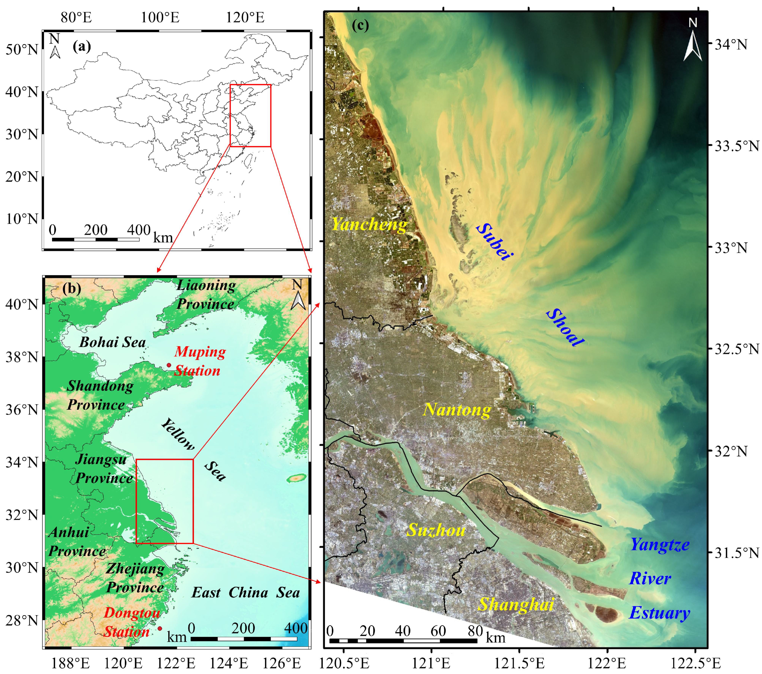
2.1. Study Area
2.2. In Situ Data
2.3. Satellite Data
3. Methods
3.1. Reflectance at Top of Atmosphere
3.2. Atmospheric Correction
3.2.1. CZI Rayleigh Correction
3.2.2. CZI Aerosol Correction
Semi-Empirical Radiative Transfer Model
Implementation of ESOA_CZI Based on a Genetic Algorithm
3.2.3. OLI Atmospheric Correction
3.3. Inversion of Suspended Particulate Matter Concentration
3.4. Accuracy Evaluation
4. Results
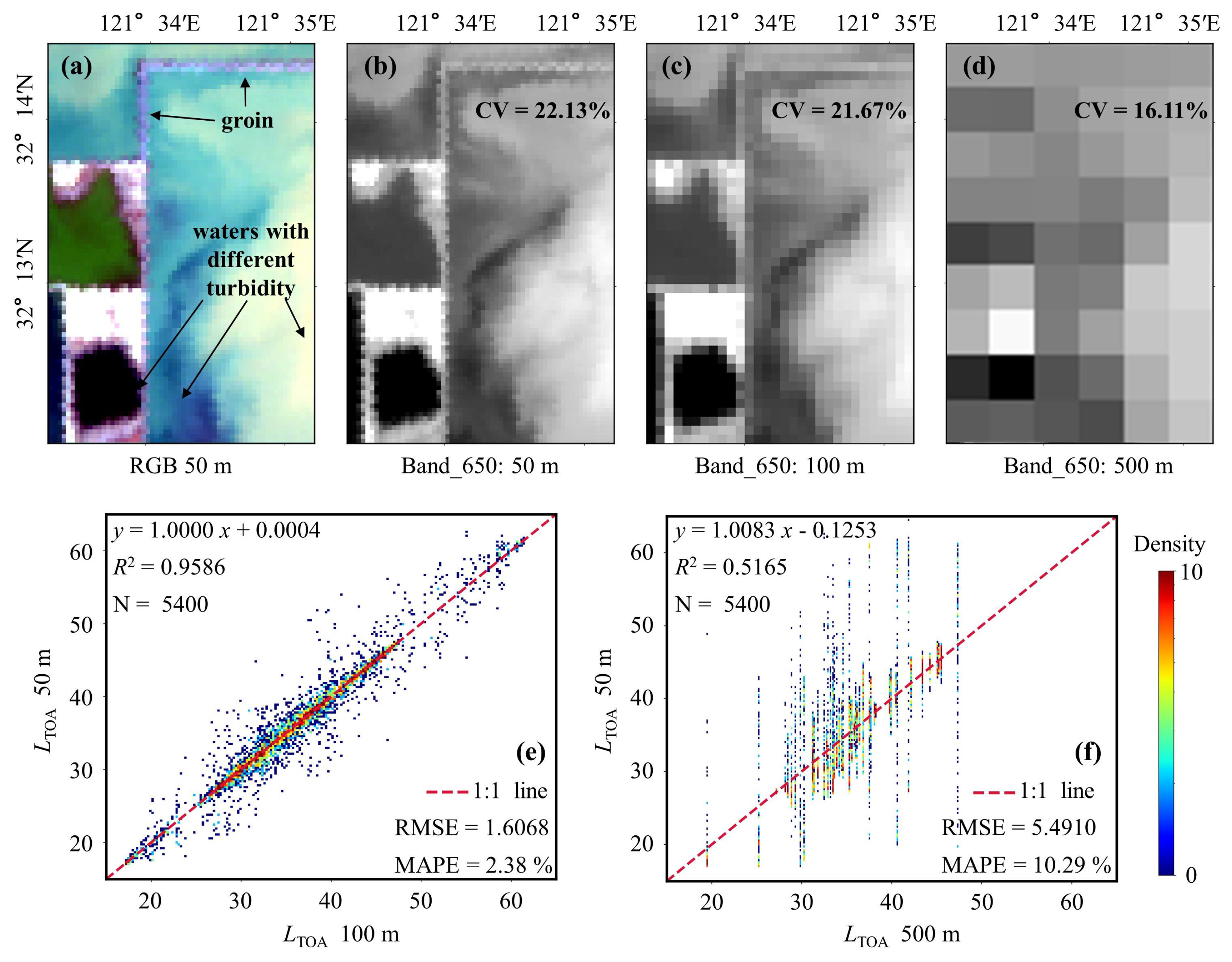
4.1. Comparison of TOA Reflectance between CZI and OLI
4.2. Rrs Comparison and Validation
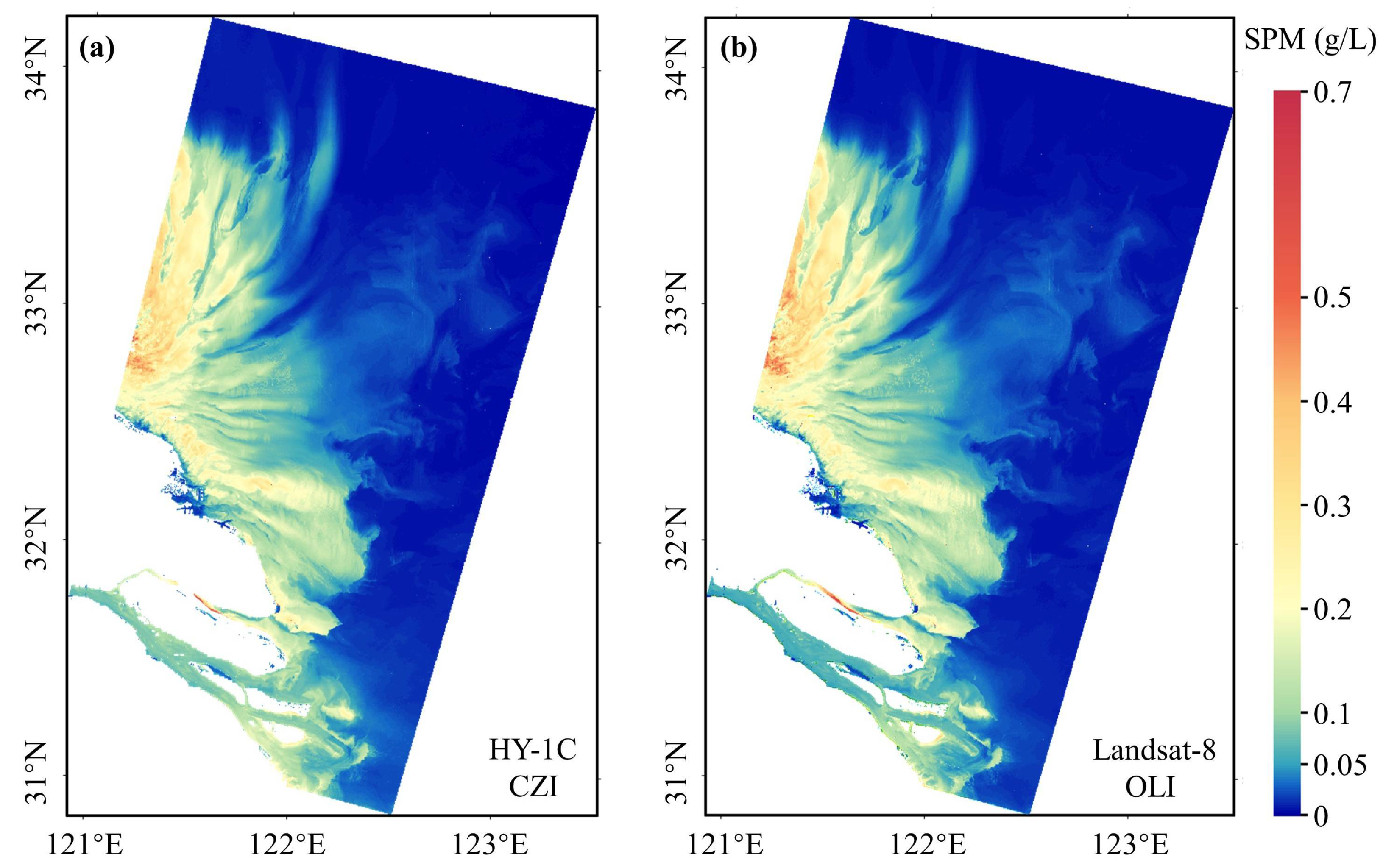
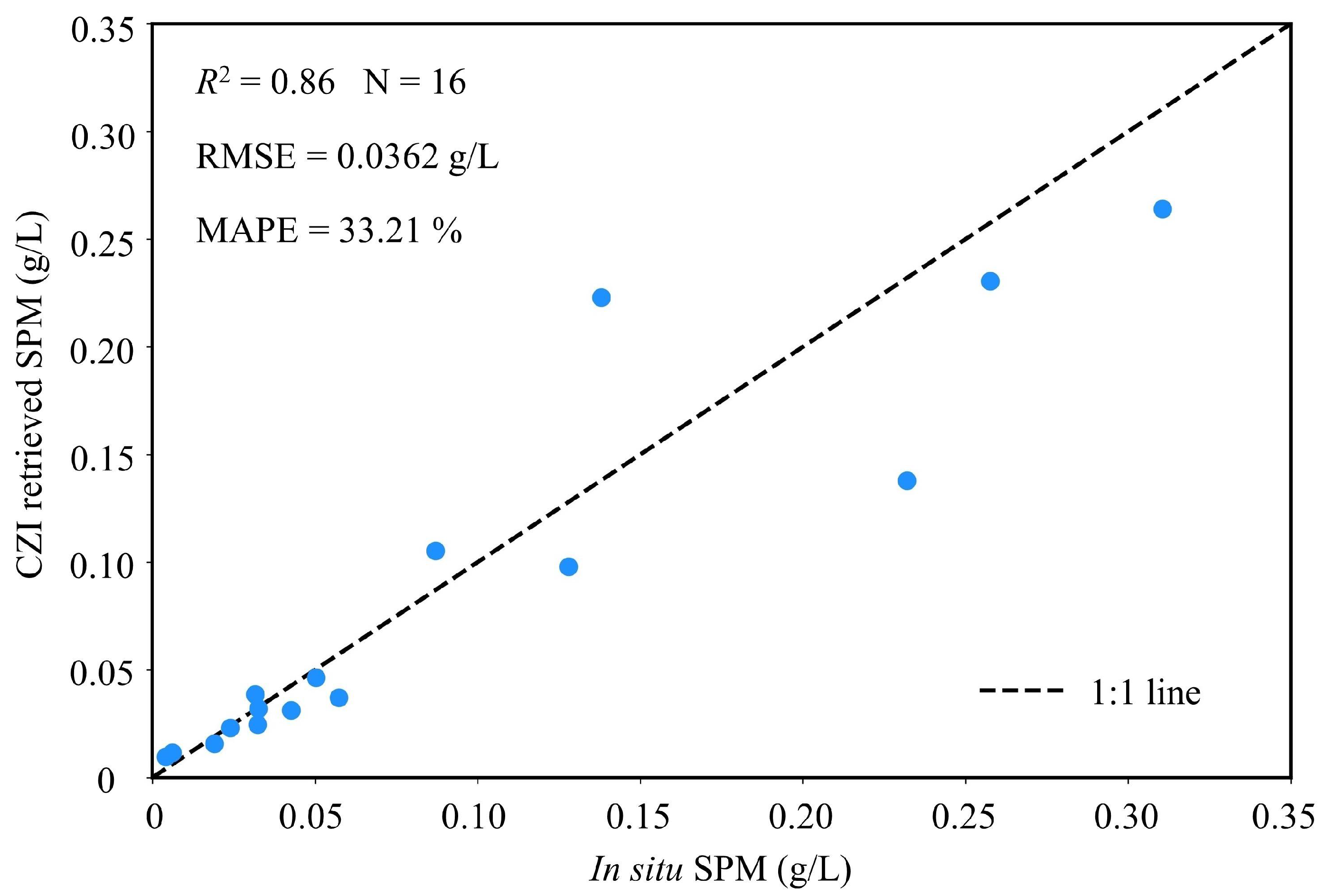
4.3. Comparison and Validation of CZI and OLI for Quantifying SPM
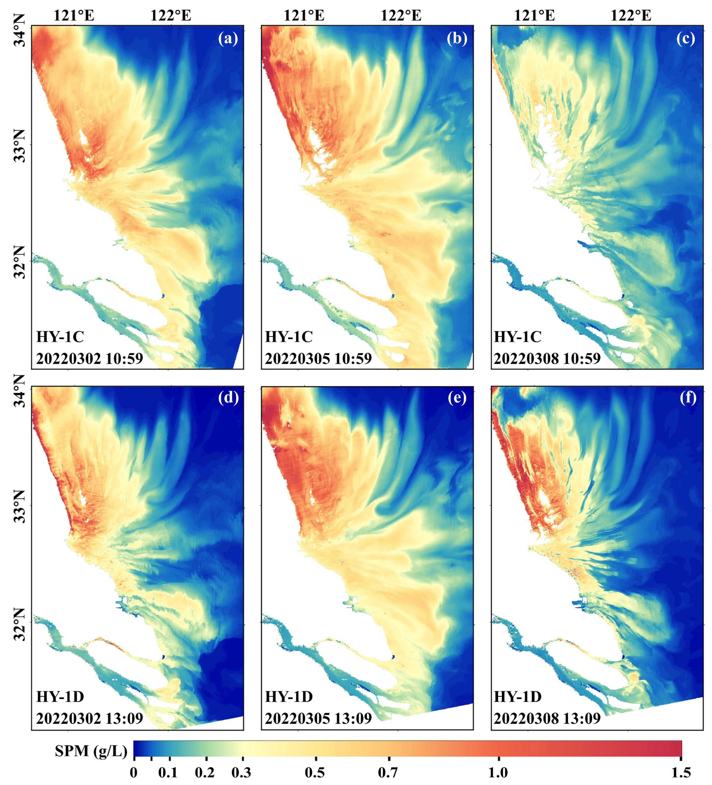
4.4. CZI Images for Quantifying SPM
4.5. Advantages of Fine Spatial Resolution
5. Discussion
6. Conclusions
Supplementary Materials
Author Contributions
Funding
Data Availability Statement
Acknowledgments
Conflicts of Interest
References
- Liu, J.A.; Liu, D.; Du, J. Radium-traced nutrient outwelling from the Subei Shoal to the Yellow Sea: Fluxes and environmental implication. Acta Oceanol. Sin. 2022, 41, 12–21. [Google Scholar] [CrossRef]
- Zhao, S.; Xu, B.; Yao, Q.; Burnett, W.C.; Charette, M.A.; Su, R.; Lian, E.; Yu, Z. Nutrient-rich submarine groundwater discharge fuels the largest green tide in the world. Sci. Total Environ. 2021, 770, 144845. [Google Scholar] [CrossRef] [PubMed]
- Guo, L.; Zhu, C.; Xie, W.; Xu, F.; Wu, H.; Wan, Y.; Wang, Z.; Zhang, W.; Shen, J.; Wang, Z.B.; et al. Changjiang Delta in the Anthropocene: Multi-scale hydro-morphodynamics and management challenges. Earth Sci. Rev. 2021, 223, 103850. [Google Scholar] [CrossRef]
- Arena, M.; Pratolongo, P.; Delgado, A.L.; Celleri, C.; Vitale, A. Spatial and temporal distribution of satellite turbidity in response to different environmental variables in the Bahía Blanca Estuary, South-Western Atlantic. Int. J. Remote Sens. 2022, 43, 3714–3743. [Google Scholar] [CrossRef]
- Chen, S.; Zhang, G.; Yang, S.; Shi, J.Z. Temporal variations of fine suspended sediment concentration in the Changjiang River estuary and adjacent coastal waters, China. J. Hydrol. 2006, 331, 137–145. [Google Scholar] [CrossRef]
- Cai, L.; Chen, S.; Yan, X.; Bai, Y.; Bu, J. Study on High-Resolution Suspended Sediment Distribution under the Influence of Coastal Zone Engineering in the Yangtze River Mouth, China. Remote Sens. 2022, 14, 486. [Google Scholar] [CrossRef]
- Tang, R.; Shen, F.; Ge, J.; Yang, S.; Gao, W. Investigating typhoon impact on SSC through hourly satellite and real-time field observations: A case study of the Yangtze Estuary. Cont. Shelf Res. 2021, 224, 104475. [Google Scholar] [CrossRef]
- Luo, W.; Shen, F.; He, Q.; Cao, F.; Zhao, H.; Li, M. Changes in suspended sediments in the Yangtze River Estuary from 1984 to 2020: Responses to basin and estuarine engineering constructions. Sci. Total Environ. 2022, 805, 150381. [Google Scholar] [CrossRef] [PubMed]
- Pahlevan, N.; Smith, B.; Alikas, K.; Anstee, J.; Barbosa, C.; Binding, C.; Bresciani, M.; Cremella, B.; Giardino, C.; Gurlin, D.; et al. Simultaneous retrieval of selected optical water quality indicators from Landsat-8, Sentinel-2, and Sentinel-3. Remote Sens. Environ. 2022, 270, 112860. [Google Scholar] [CrossRef]
- Vanhellemont, Q.; Ruddick, K. Turbid wakes associated with offshore wind turbines observed with Landsat 8. Remote Sens. Environ. 2014, 145, 105–115. [Google Scholar] [CrossRef]
- Estrella, E.H.; Gilerson, A.; Foster, R.; Groetsch, P. Spectral decomposition of remote sensing reflectance variance due to the spatial variability from ocean color and high-resolution satellite sensors. J. Appl. Remote Sens. 2021, 15, 24522. [Google Scholar] [CrossRef]
- Tong, C.; Mu, B.; Liu, R.; Ding, J.; Zhang, M.; Xiao, Y.; Liang, X.; Chen, X. Atmospheric Correction Algorithm for HY-1C CZI over Turbid Waters. J. Coast. Res. 2019, 90, 156–163. [Google Scholar] [CrossRef]
- Men, J.; Liu, J.; Xia, G.; Yue, T.; Tong, R.; Tian, L.; Arai, K.; Wang, L. Atmospheric correction for HY-1C CZI images using neural network in western Pacific region. Geo-spatial Inf. Sci. 2022, 25, 476–488. [Google Scholar] [CrossRef]
- Huang, Y.Y.; Tang, S.L.; Wu, J. A chlorophyll-a retrieval algorithm for the Coastal Zone Imager (CZI) onboard the HY-1C satellite in the Pearl River Estuary, China. Int. J. Remote Sens. 2021, 42, 8365–8379. [Google Scholar] [CrossRef]
- Cheng, Y.; Sun, Y.; Peng, L.; He, Y.; Zha, M. An Improved Retrieval Method for Porphyra Cultivation Area Based on Suspended Sediment Concentration. Remote Sens. 2022, 14, 4338. [Google Scholar] [CrossRef]
- Zhu, X.; Lu, Y.; Liu, J.; Ju, W.; Ding, J.; Li, M.; Suo, Z.; Jiao, J.; Wang, L. Optical Extraction of Oil Spills from Satellite Images Under Different Sunglint Reflections. Ieee T. Geosci. Remote. 2022, 60, 1–14. [Google Scholar] [CrossRef]
- Zhao, X.; Liu, R.; Ma, Y.; Xiao, Y.; Ding, J.; Liu, J.; Wang, Q. Red Tide Detection Method for HY−1D Coastal Zone Imager Based on U−Net Convolutional Neural Network. Remote Sens. 2022, 14, 88. [Google Scholar] [CrossRef]
- Ji, H.; Tian, L.; Li, J.; Tong, R.; Guo, Y.; Zeng, Q. Spatial–Spectral Fusion of HY-1C COCTS/CZI Data for Coastal Water Remote Sensing Using Deep Belief Network. IEEE J. Stars. 2021, 14, 1693–1704. [Google Scholar] [CrossRef]
- Pahlevan, N.; Mangin, A.; Balasubramanian, S.V.; Smith, B.; Alikas, K.; Arai, K.; Barbosa, C.; Bélanger, S.; Binding, C.; Bresciani, M.; et al. ACIX-Aqua: A global assessment of atmospheric correction methods for Landsat-8 and Sentinel-2 over lakes, rivers, and coastal waters. Remote Sens. Environ. 2021, 258, 112366. [Google Scholar] [CrossRef]
- Gordon, H.R. Atmospheric correction of ocean color imagery in the Earth Observing System era. J. Geophys. Res. Atmos. 1997, 102, 17081–17106. [Google Scholar] [CrossRef]
- Gordon, H.R.; Wang, M. Retrieval of water-leaving radiance and aerosol optical thickness over the oceans with SeaWiFS: A preliminary algorithm. Appl. Opt. 1994, 33, 443–452. [Google Scholar] [CrossRef]
- Vanhellemont, Q.; Ruddick, K. Atmospheric correction of Sentinel-3/OLCI data for mapping of suspended particulate matter and chlorophyll-a concentration in Belgian turbid coastal waters. Remote Sens. Environ. 2021, 256, 112284. [Google Scholar] [CrossRef]
- Xu, Y.; He, X.; Bai, Y.; Wang, D.; Zhu, Q.; Ding, X. Evaluation of Remote-Sensing Reflectance Products from Multiple Ocean Color Missions in Highly Turbid Water (Hangzhou Bay). Remote Sens. 2021, 13, 4267. [Google Scholar] [CrossRef]
- Pan, Y.; Shen, F.; Verhoef, W. An improved spectral optimization algorithm for atmospheric correction over turbid coastal waters: A case study from the Changjiang (Yangtze) estuary and the adjacent coast. Remote Sens. Environ. 2017, 191, 197–214. [Google Scholar] [CrossRef] [Green Version]
- Vanhellemont, Q.; Ruddick, K. Advantages of high quality SWIR bands for ocean colour processing: Examples from Landsat-8. Remote Sens. Environ. 2015, 161, 89–106. [Google Scholar] [CrossRef] [Green Version]
- Wang, M. Estimation of ocean contribution at the MODIS near-infrared wavelengths along the east coast of the U.S.: Two case studies. Geophys. Res. Lett. 2005, 32. [Google Scholar] [CrossRef] [Green Version]
- Werdell, P.J.; Franz, B.A.; Bailey, S.W. Evaluation of shortwave infrared atmospheric correction for ocean color remote sensing of Chesapeake Bay. Remote Sens. Environ. 2010, 114, 2238–2247. [Google Scholar] [CrossRef] [Green Version]
- Wang, M.; Shi, W. The NIR-SWIR combined atmospheric correction approach for MODIS ocean color data processing. Opt. Express. 2007, 15, 15722–15733. [Google Scholar] [CrossRef] [Green Version]
- Wang, J.; Lee, Z.; Wang, D.; Shang, S.; Wei, J.; Gilerson, A. Atmospheric correction over coastal waters with aerosol properties constrained by multi-pixel observations. Remote Sens. Environ. 2021, 265, 112633. [Google Scholar] [CrossRef]
- Wang, J.; Wang, Y.; Lee, Z.; Wang, D.; Chen, S.; Lai, W. A revision of NASA SeaDAS atmospheric correction algorithm over turbid waters with artificial Neural Networks estimated remote-sensing reflectance in the near-infrared. Isprs J. Photogramm. 2022, 194, 235–249. [Google Scholar] [CrossRef]
- Miao, X.; Xiao, J.; Xu, Q.; Fan, S.; Wang, Z.; Wang, X.; Zhang, X. Distribution and species diversity of the floating green macroalgae and micro-propagules in the Subei Shoal, southwestern Yellow Sea. Peer J. 2020, 8, e10538. [Google Scholar] [CrossRef]
- Xiao, J.; Fan, S.; Wang, Z.; Fu, M.; Song, H.; Wang, X.; Yuan, C.; Pang, M.; Miao, X.; Zhang, X. Decadal characteristics of the floating Ulva and Sargassum in the Subei Shoal, Yellow Sea. Acta Oceanol. Sin. 2020, 39, 1–10. [Google Scholar] [CrossRef]
- Yuan, D.; Li, Y.; Wang, B.; He, L.; Hirose, N. Coastal circulation in the southwestern Yellow Sea in the summers of 2008 and 2009. Cont. Shelf Res. 2017, 143, 101–117. [Google Scholar] [CrossRef]
- Mobley, C.D. Estimation of the remote-sensing reflectance from above-surface measurements. Appl. Opt. 1999, 38, 7442. [Google Scholar] [CrossRef] [PubMed]
- Sun, D.; Chen, Y.; Wang, S.; Zhang, H.; Qiu, Z.; Mao, Z.; He, Y. Using Landsat 8 OLI data to differentiate Sargassum and Ulva prolifera blooms in the South Yellow Sea. Int. J. Appl. Earth Obs. 2021, 98, 102302. [Google Scholar] [CrossRef]
- He, X.; Bai, Y.; Zhu, Q.; Gong, F. A vector radiative transfer model of coupled ocean–atmosphere system using matrix-operator method for rough sea-surface. J. Quant. Spectrosc. Radiat. Transf. 2010, 111, 1426–1448. [Google Scholar] [CrossRef]
- He, X.Q.; Pan, D.L.; Bai, Y.; Gong, F. General purpose exact Rayleigh scattering look-up table for ocean color remote sensing. Acta Oceanol. Sin. 2006, 25, 48–56. [Google Scholar]
- Kubelka, P.; Munk, F. Ein Beitrag Zur Optik der Farbanstriche. Z. Tech. Physik. 1931, 12, 593–601. [Google Scholar]
- Shen, F.; Verhoef, W.; Zhou, Y.; Salama, M.S.; Liu, X. Satellite Estimates of Wide-Range Suspended Sediment Concentrations in Changjiang (Yangtze) Estuary Using MERIS Data. Estuar. Coast. 2010, 33, 1420–1429. [Google Scholar] [CrossRef]
- Ahmad, Z.; Franz, B.A.; McClain, C.R.; Kwiatkowska, E.J.; Werdell, J.; Shettle, E.P.; Holben, B.N. New aerosol models for the retrieval of aerosol optical thickness and normalized water-leaving radiances from the SeaWiFS and MODIS sensors over coastal regions and open oceans. Appl. Opt. 2010, 49, 5545–5560. [Google Scholar] [CrossRef]
- He, X.; Bai, Y.; Pan, D.; Tang, J.; Wang, D. Atmospheric correction of satellite ocean color imagery using the ultraviolet wavelength for highly turbid waters. Opt. Express 2012, 20, 20754–20770. [Google Scholar] [CrossRef] [PubMed]
- Kuchinke, C.P.; Gordon, H.R.; Franz, B.A. Spectral optimization for constituent retrieval in Case 2 waters I: Implementation and performance. Remote Sens. Environ. 2009, 113, 571–587. [Google Scholar] [CrossRef]
- Normandin, C.; Lubac, B.; Sottolichio, A.; Frappart, F.; Ygorra, B.; Marieu, V. Analysis of Suspended Sediment Variability in a Large Highly Turbid Estuary Using a 5-Year-Long Remotely Sensed Data Archive at High Resolution. J. Geophys. Res. Ocean. 2019, 124, 7661–7682. [Google Scholar] [CrossRef] [Green Version]
- Vanhellemont, Q. Adaptation of the dark spectrum fitting atmospheric correction for aquatic applications of the Landsat and Sentinel-2 archives. Remote Sens. Environ. 2019, 225, 175–192. [Google Scholar] [CrossRef]
- IOCCG. Uncertainties in Ocean Colour Remote Sensing; Melin, F., Ed.; Volume No. 18 of Reports of the International Ocean Colour Coordinating Group; IOCCG: Dartmouth, Canada, 2019. [Google Scholar]
- Li, J.; Chen, X.; Tian, L.; Huang, J.; Feng, L. Improved capabilities of the Chinese high-resolution remote sensing satellite GF-1 for monitoring suspended particulate matter (SPM) in inland waters: Radiometric and spatial considerations. Isprs. J. Photogramm. 2015, 106, 145–156. [Google Scholar] [CrossRef]
- Li, P.; Yang, S.L.; Milliman, J.D.; Xu, K.H.; Qin, W.H.; Wu, C.S.; Chen, Y.P.; Shi, B.W. Spatial, Temporal, and Human-Induced Variations in Suspended Sediment Concentration in the Surface Waters of the Yangtze Estuary and Adjacent Coastal Areas. Estuar. Coast. 2012, 35, 1316–1327. [Google Scholar] [CrossRef]


| Satellite/Sensor | Landsat-8/9: OLI | HY-1C/D: CZI |
|---|---|---|
| Revisit (days) | Single: 16 Networking: 8 | Single: 3 Networking: twice every 3 days |
| Scene Size (km) | 185 | 950 |
| Path time | 10:00 a.m. ± 15 min local time | C: 10:30 a.m. ± 30 min local timeD: 1:30 p.m. ± 30 min local time |
| Center band for CZI (nm) | u | v | RMSE (sr−1) | MAE (sr−1) | MAPE (%) | Correlation (R2, N = 716) |
|---|---|---|---|---|---|---|
| 460 | 0.0246 | 419.1596 | 0.0048 | 0.0038 | 44.16 | 0.6300 |
| 560 | 0.0466 | 146.1654 | 0.0060 | 0.0047 | 36.75 | 0.8126 |
| 650 | 0.0699 | 32.5096 | 0.0053 | 0.0039 | 41.03 | 0.9121 |
| 825 | 0.0984 | 3.8635 | 0.0034 | 0.0024 | 72.46 | 0.9392 |
Disclaimer/Publisher’s Note: The statements, opinions and data contained in all publications are solely those of the individual author(s) and contributor(s) and not of MDPI and/or the editor(s). MDPI and/or the editor(s) disclaim responsibility for any injury to people or property resulting from any ideas, methods, instructions or products referred to in the content. |
© 2023 by the authors. Licensee MDPI, Basel, Switzerland. This article is an open access article distributed under the terms and conditions of the Creative Commons Attribution (CC BY) license (https://creativecommons.org/licenses/by/4.0/).
Share and Cite
Luo, W.; Li, R.; Shen, F.; Liu, J. HY-1C/D CZI Image Atmospheric Correction and Quantifying Suspended Particulate Matter. Remote Sens. 2023, 15, 386. https://doi.org/10.3390/rs15020386
Luo W, Li R, Shen F, Liu J. HY-1C/D CZI Image Atmospheric Correction and Quantifying Suspended Particulate Matter. Remote Sensing. 2023; 15(2):386. https://doi.org/10.3390/rs15020386
Chicago/Turabian StyleLuo, Wei, Renhu Li, Fang Shen, and Jianqiang Liu. 2023. "HY-1C/D CZI Image Atmospheric Correction and Quantifying Suspended Particulate Matter" Remote Sensing 15, no. 2: 386. https://doi.org/10.3390/rs15020386
APA StyleLuo, W., Li, R., Shen, F., & Liu, J. (2023). HY-1C/D CZI Image Atmospheric Correction and Quantifying Suspended Particulate Matter. Remote Sensing, 15(2), 386. https://doi.org/10.3390/rs15020386


