

Evaluation of Satellite-Based Precipitation Products over Complex Topography in Mountainous Southwestern China

Abstract
:1. Introduction
2. Materials
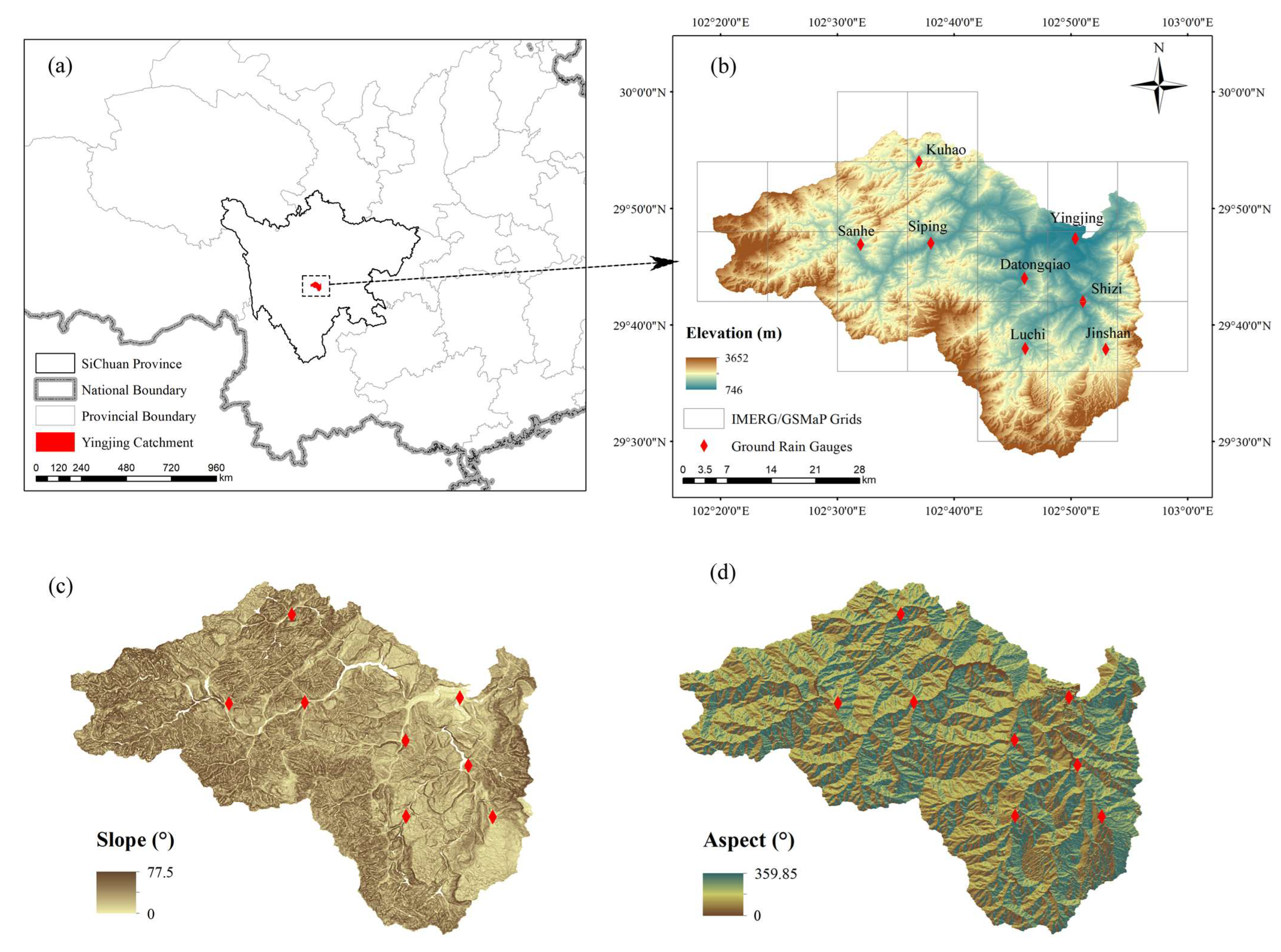
2.1. Study Area
2.2. Data Set
2.2.1. Digital Elevation Model
2.2.2. In Situ Data of Precipitation
2.2.3. IMERG
2.2.4. GSMaP
3. Methodology
4. Results
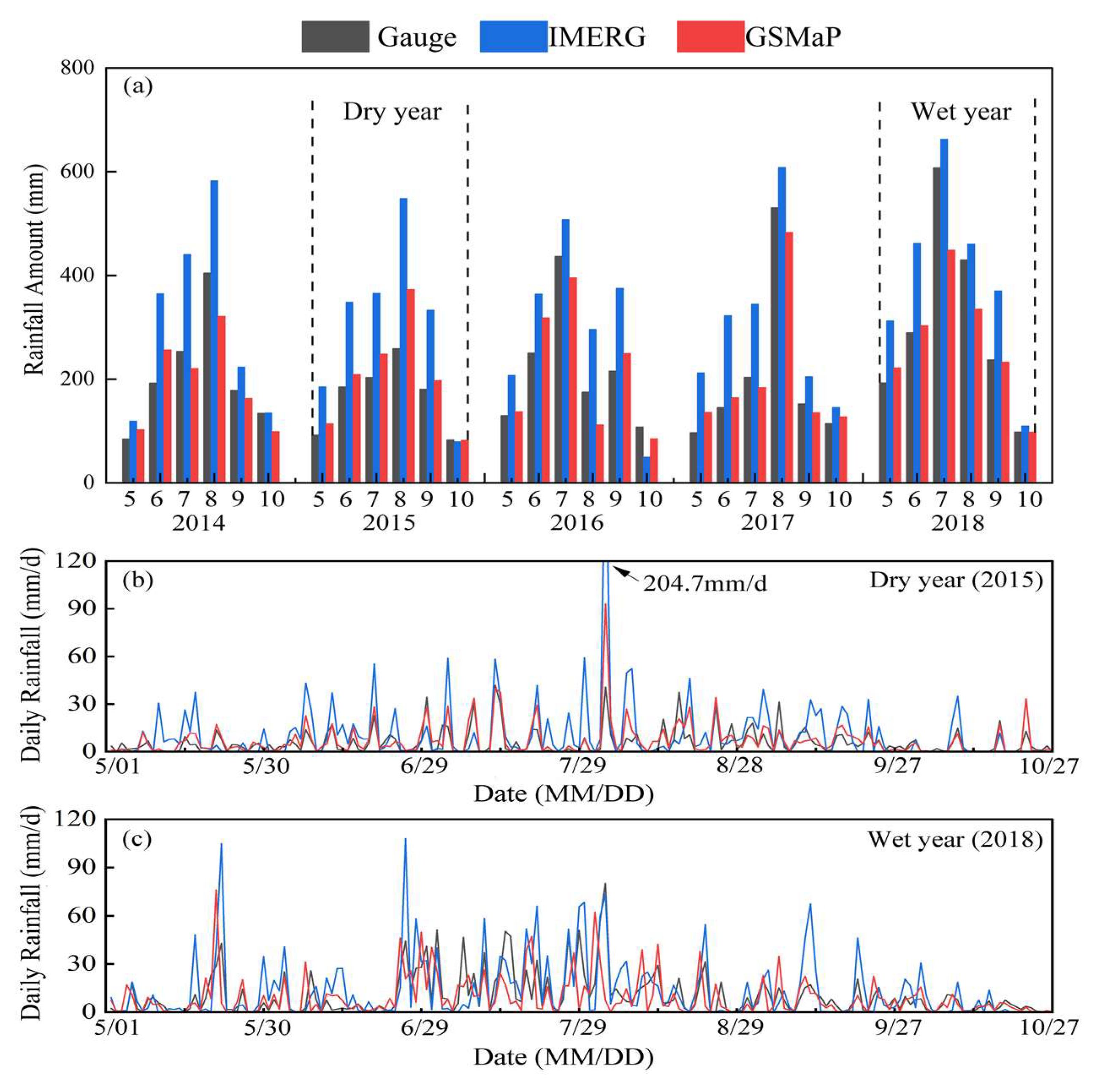
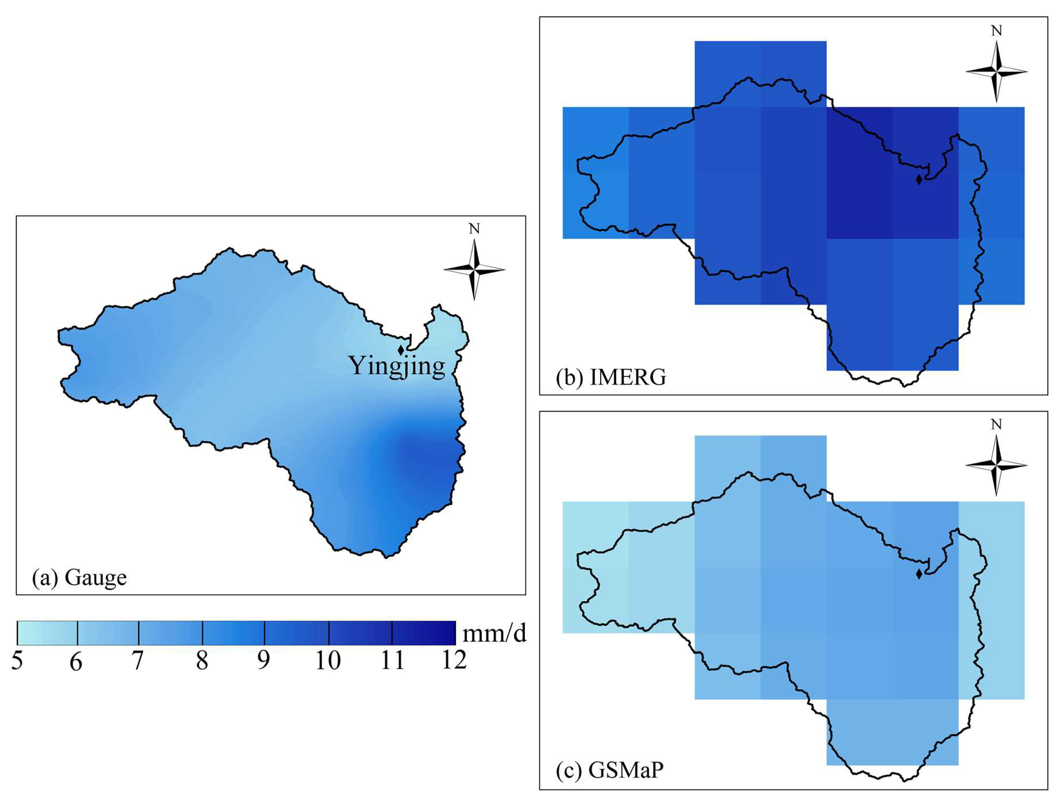
4.1. Temporal and Spatial Distribution of Gauge and Satellite Data sets
4.2. Evaluation of Satellite Precipitation
4.3. Evaluation of the Dependence of the Performance of Rainfall Products on Topography Factors
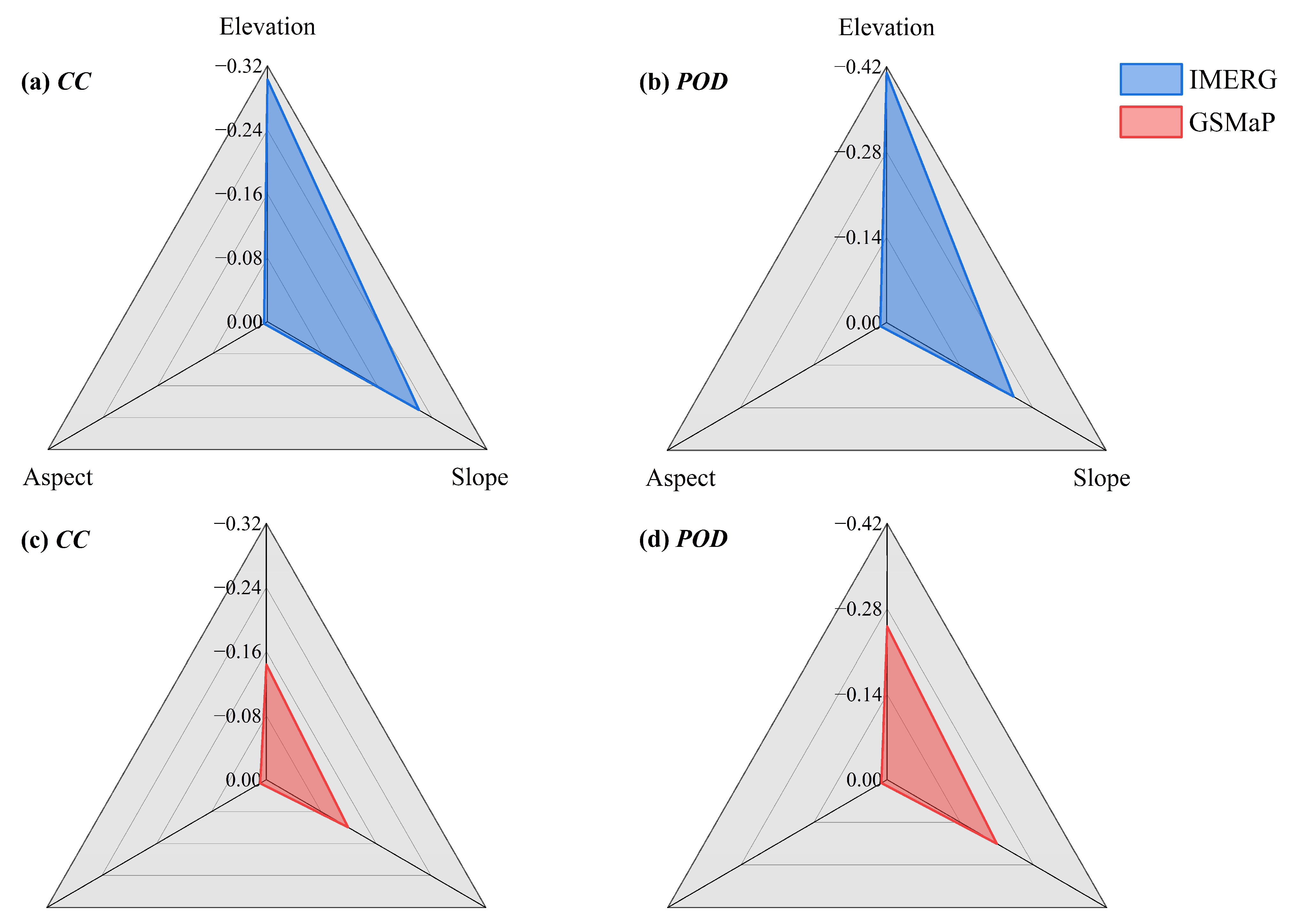
4.3.1. Comprehensive Evaluation of the Influence of Elevation, Slope and Aspect
4.3.2. Dependence of the Performance of Rainfall Products on Elevation
4.3.3. Dependence of the Performance of Rainfall Products on Slope
5. Discussion
5.1. Influence of Terrain Factors
5.2. Uncertainty of the Rainy Season
5.3. Uncertainty of Rainfall Intensity
6. Conclusions
Author Contributions
Funding
Institutional Review Board Statement
Informed Consent Statement
Data Availability Statement
Acknowledgments
Conflicts of Interest
References
- Kundzewicz, Z.W.; Su, B.; Wang, Y.; Xia, J.; Huang, J.; Jiang, T. Flood risk and its reduction in China. Adv. Water Resour. 2019, 130, 37–45. [Google Scholar] [CrossRef]
- Borga, M.; Anagnostou, E.N.; Blöschl, G.; Creutin, J.D. Flash flood forecasting, warning and risk management: The HYDRATE project. Environ. Sci. Policy 2011, 14, 834–844. [Google Scholar] [CrossRef]
- Chen, Z.; Wei, S. Application of System Dynamics to Water Security Research. Water Resour. Manag. 2013, 28, 287–300. [Google Scholar] [CrossRef]
- Mosavi, A.; Ozturk, P.; Chau, K.-w. Flood Prediction Using Machine Learning Models: Literature Review. Water 2018, 10, 1536. [Google Scholar] [CrossRef] [Green Version]
- Aslam, M. Flood Management Current State, Challenges and Prospects in Pakistan: A Review. Mehran Univ. Res. J. Eng. Technol. 2018, 37, 297–314. [Google Scholar] [CrossRef] [Green Version]
- Brunner, M.I.; Slater, L.; Tallaksen, L.M.; Clark, M. Challenges in modeling and predicting floods and droughts: A review. WIREs Water 2021, 8, e1520. [Google Scholar] [CrossRef]
- Liu, C.-C.; Shieh, M.-C.; Ke, M.-S.; Wang, K.-H. Flood Prevention and Emergency Response System Powered by Google Earth Engine. Remote Sens. 2018, 10, 1283. [Google Scholar] [CrossRef] [Green Version]
- Todini, E. Flood Forecasting and Decision Making in the new Millennium. Where are We? Water Resour. Manag. 2017, 31, 3111–3129. [Google Scholar] [CrossRef]
- Maggioni, V.; Meyers, P.C.; Robinson, M.D. A Review of Merged High-Resolution Satellite Precipitation Product Accuracy during the Tropical Rainfall Measuring Mission (TRMM) Era. J. Hydrometeorol. 2016, 17, 1101–1117. [Google Scholar] [CrossRef]
- Funk, C.; Peterson, P.; Landsfeld, M.; Pedreros, D.; Verdin, J.; Shukla, S.; Husak, G.; Rowland, J.; Harrison, L.; Hoell, A.; et al. The climate hazards infrared precipitation with stations—A new environmental record for monitoring extremes. Sci. Data 2015, 2, 150066. [Google Scholar] [CrossRef]
- Huffman, G.J.; Wolff, D.B.; Nelkin, E.J.; Bolvin, D.T.; Adler, R.F.; Gu, G.; Hong, Y.; Bowman, K.P.; Stocker, E.F. The TRMM Multisatellite Precipitation Analysis (TMPA): Quasi-Global, Multiyear, Combined-Sensor Precipitation Estimates at Fine Scales. J. Hydrometeorol. 2007, 8, 38–55. [Google Scholar] [CrossRef]
- Jyce, R.J.; Janowiak, J.E.; Arkin, P.A.; Xie, P. CMORPH: A Method that Produces Global Precipitation Estimates from Passive Microwave and Infrared Data at High Spatial and Temporal Resolution. J. Hydrometeorol. 2004, 5, 487–503. [Google Scholar] [CrossRef]
- Sorooshian, S.; Hsu, K.-L.; Gao, X.; Gupta, H.V.; Imam, B.; Braithwaite, D. Evaluation of PERSIANN System Satellite–Based Estimates of Tropical Rainfall. Bull. Am. Meteorol. Soc. 2000, 81, 2035–2046. [Google Scholar] [CrossRef]
- Gao, F.; Zhang, Y.; Chen, Q.; Wang, P.; Yang, H.; Yao, Y.; Cai, W. Comparison of two long-term and high-resolution satellite precipitation datasets in Xinjiang, China. Atmos. Res. 2018, 212, 150–157. [Google Scholar] [CrossRef]
- Hou, A.Y.; Kakar, R.K.; Neeck, S.; Azarbarzin, A.A.; Kummerow, C.D.; Kojima, M.; Oki, R.; Nakamura, K.; Iguchi, T. The Global Precipitation Measurement Mission. Bull. Am. Meteorol. Soc. 2014, 95, 701–722. [Google Scholar] [CrossRef]
- Zhang, L.; Li, X.; Zheng, D.; Zhang, K.; Ma, Q.; Zhao, Y.; Ge, Y. Merging multiple satellite-based precipitation products and gauge observations using a novel double machine learning approach. J. Hydrol. 2021, 594, 125969. [Google Scholar] [CrossRef]
- Wang, X.; Li, B.; Chen, Y.; Guo, H.; Wang, Y.; Lian, L. Applicability Evaluation of Multisource Satellite Precipitation Data for Hydrological Research in Arid Mountainous Areas. Remote Sens. 2020, 12, 2886. [Google Scholar] [CrossRef]
- Xiao, S.; Xia, J.; Zou, L. Evaluation of Multi-Satellite Precipitation Products and Their Ability in Capturing the Characteristics of Extreme Climate Events over the Yangtze River Basin, China. Water 2020, 12, 1179. [Google Scholar] [CrossRef] [Green Version]
- Liu, Z. Comparison of Integrated Multisatellite Retrievals for GPM (IMERG) and TRMM Multisatellite Precipitation Analysis (TMPA) Monthly Precipitation Products: Initial Results. J. Hydrometeorol. 2016, 17, 777–790. [Google Scholar] [CrossRef]
- Murali Krishna, U.V.; Das, S.K.; Deshpande, S.M.; Doiphode, S.L.; Pandithurai, G. The assessment of Global Precipitation Measurement estimates over the Indian subcontinent. Earth Space Sci. 2017, 4, 540–553. [Google Scholar] [CrossRef]
- Omranian, E.; Sharif, H.; Tavakoly, A. How Well Can Global Precipitation Measurement (GPM) Capture Hurricanes? Case Study: Hurricane Harvey. Remote Sens. 2018, 10, 1150. [Google Scholar] [CrossRef] [Green Version]
- Sakib, S.; Ghebreyesus, D.; Sharif, H.O. Performance Evaluation of IMERG GPM Products during Tropical Storm Imelda. Atmosphere 2021, 12, 687. [Google Scholar] [CrossRef]
- Gautam, A.K.; Pandey, A. Ground validation of GPM Day-1 IMERG and TMPA Version-7 products over different rainfall regimes in India. Theor. Appl. Climatol. 2022, 149, 931–943. [Google Scholar] [CrossRef]
- Chen, F.; Li, X. Evaluation of IMERG and TRMM 3B43 Monthly Precipitation Products over Mainland China. Remote Sens. 2016, 8, 472. [Google Scholar] [CrossRef] [Green Version]
- Zhang, L.; He, C.; Tian, W.; Zhu, Y. Evaluation of Precipitation Datasets from TRMM Satellite and Down-scaled Reanalysis Products with Bias-correction in Middle Qilian Mountain, China. Chin. Geogr. Sci. 2021, 31, 474–490. [Google Scholar] [CrossRef]
- Omranian, E.; Sharif, H.O. Evaluation of the Global Precipitation Measurement (GPM) Satellite Rainfall Products over the Lower Colorado River Basin, Texas. JAWRA J. Am. Water Resour. Assoc. 2018, 54, 882–898. [Google Scholar] [CrossRef]
- Anjum; Ahmad; Ding; Shangguan; Zaman; Ijaz; Sarwar; Han; Yang. Assessment of IMERG-V06 Precipitation Product over Different Hydro-Climatic Regimes in the Tianshan Mountains, North-Western China. Remote Sens. 2019, 11, 2314. [Google Scholar] [CrossRef] [Green Version]
- Sunilkumar, K.; Narayana Rao, T.; Saikranthi, K.; Purnachandra Rao, M. Comprehensive evaluation of multisatellite precipitation estimates over India using gridded rainfall data. J. Geophys. Res. Atmos. 2015, 120, 8987–9005. [Google Scholar] [CrossRef] [Green Version]
- Tang, X.; Yin, Z.; Qin, G.; Guo, L.; Li, H. Integration of Satellite Precipitation Data and Deep Learning for Improving Flash Flood Simulation in a Poor-Gauged Mountainous Catchment. Remote Sens. 2021, 13, 5083. [Google Scholar] [CrossRef]
- Xu, R.; Tian, F.; Yang, L.; Hu, H.; Lu, H.; Hou, A. Ground validation of GPM IMERG and TRMM 3B42V7 rainfall products over southern Tibetan Plateau based on a high-density rain gauge network. J. Geophys. Res. Atmos. 2017, 122, 910–924. [Google Scholar] [CrossRef]
- Lu, C.; Ye, J.; Fang, G.; Huang, X.; Yan, M. Assessment of GPM IMERG Satellite Precipitation Estimation under Complex Climatic and Topographic Conditions. Atmosphere 2021, 12, 780. [Google Scholar] [CrossRef]
- Bharti, V.; Singh, C. Evaluation of error in TRMM 3B42V7 precipitation estimates over the Himalayan region. J. Geophys. Res. Atmos. 2015, 120, 12458–12473. [Google Scholar] [CrossRef]
- Bhuiyan, M.A.E.; Yang, F.; Biswas, N.K.; Rahat, S.H.; Neelam, T.J. Machine Learning-Based Error Modeling to Improve GPM IMERG Precipitation Product over the Brahmaputra River Basin. Forecasting 2020, 2, 248–266. [Google Scholar] [CrossRef]
- Tang, G.; Ma, Y.; Long, D.; Zhong, L.; Hong, Y. Evaluation of GPM Day-1 IMERG and TMPA Version-7 legacy products over Mainland China at multiple spatiotemporal scales. J. Hydrol. 2016, 533, 152–167. [Google Scholar] [CrossRef]
- Wang, R.M.; Li, H.X.; Huang, Q. Flood Forecasting of Small-medium Rivers in Southwest China Using HEC-HMS Model. Water Resour. Power 2021, 39, 79–82. [Google Scholar]
- Xia, T.; Wang, Z.-J.; Zheng, H. Topography and Data Mining Based Methods for Improving Satellite Precipitation in Mountainous Areas of China. Atmosphere 2015, 6, 983–1005. [Google Scholar] [CrossRef] [Green Version]
- Wong, J.S.; Wheater, H.S.; Razavi, S.; Asong, Z.E. Evaluation of Integrated Multisatellite Retrievals for GPM (IMERG) over Southern Canada against Ground Precipitation Observations: A Preliminary Assessment. J. Hydrometeorol. 2017, 18, 1033–1050. [Google Scholar] [CrossRef]
- Hu, H.; Hu, Y.; Zhong, Z. Double nested dynamical downscaling research on summer precipitation over China with WRF model. J. Meteorol. Sci. 2015, 35, 413–421. [Google Scholar] [CrossRef]
- Li, G.; Yu, Z.; Wang, W.; Ju, Q.; Chen, X. Analysis of the spatial Distribution of precipitation and topography with GPM data in the Tibetan Plateau. Atmos. Res. 2021, 247, 105259. [Google Scholar] [CrossRef]
- Shi, L.; Wan, Y.; Zhang, D.; Wang, W.; Yang, J. Precision evalution of CMPA remote sensing precipitation data in different terrians of China. J. Meteorol. Sci. 2018, 38, 616–624. [Google Scholar] [CrossRef]
- Amjad, M.; Yilmaz, M.T.; Yucel, I.; Yilmaz, K.K. Performance evaluation of satellite- and model-based precipitation products over varying climate and complex topography. J. Hydrol. 2020, 584, 124707. [Google Scholar] [CrossRef]
- Liu, J.; Xia, J.; She, D.; Li, L.; Wang, Q.; Zou, L. Evaluation of Six Satellite-Based Precipitation Products and Their Ability for Capturing Characteristics of Extreme Precipitation Events over a Climate Transition Area in China. Remote Sens. 2019, 11, 1477. [Google Scholar] [CrossRef] [Green Version]
- Deng, X.; Ye, A.; Mao, Y. TRMM precipitation evaluation for inland of China. J. China Hydrol. 2015, 35, 47–54+61. [Google Scholar]
- Yang, T.; Min, J.; Zhang, S. Two-dimensional idealized numerical experiments on the orographic rainfall with a stratified flow over mountain. J. Meteorol. Sci. 2017, 37, 222–230. [Google Scholar] [CrossRef]
- Tang, S.; Li, R.; He, J.; Wang, H.; Fan, X.; Yao, S. Comparative Evaluation of the GPM IMERG Early, Late, and Final Hourly Precipitation Products Using the CMPA Data over Sichuan Basin of China. Water 2020, 12, 554. [Google Scholar] [CrossRef] [Green Version]
- Sunilkumar, K.; Yatagai, A.; Masuda, M. Preliminary Evaluation of GPM-IMERG Rainfall Estimates Over Three Distinct Climate Zones with APHRODITE. Earth Space Sci. 2019, 6, 1321–1335. [Google Scholar] [CrossRef] [Green Version]
- Zhang, L.; Lan, P.; Qin, G.; Mello, C.R.; Boyer, E.W.; Luo, P.; Guo, L. Evaluation of Three Gridded Precipitation Products to Quantify Water Inputs over Complex Mountainous Terrain of Western China. Remote Sens. 2021, 13, 3795. [Google Scholar] [CrossRef]
- Sharifi, E.; Steinacker, R.; Saghafian, B. Assessment of GPM-IMERG and Other Precipitation Products against Gauge Data under Different Topographic and Climatic Conditions in Iran: Preliminary Results. Remote Sens. 2016, 8, 135. [Google Scholar] [CrossRef] [Green Version]
- Dipu, S.; Prabha, T.V.; Pandithurai, G.; Dudhia, J.; Pfister, G.; Rajesh, K.; Goswami, B.N. Impact of elevated aerosol layer on the cloud macrophysical properties prior to monsoon onset. Atmos. Environ. 2013, 70, 454–467. [Google Scholar] [CrossRef]
- Gao, Y.C.; Liu, M.F. Evaluation of high-resolution satellite precipitation products using rain gauge observations over the Tibetan Plateau. Hydrol. Earth Syst. Sci. 2013, 17, 837–849. [Google Scholar] [CrossRef] [Green Version]
- Li, Z.; Yang, D.; Hong, Y. Multi-scale evaluation of high-resolution multi-sensor blended global precipitation products over the Yangtze River. J. Hydrol. 2013, 500, 157–169. [Google Scholar] [CrossRef]
- Tan, M.; Ibrahim, A.; Duan, Z.; Cracknell, A.; Chaplot, V. Evaluation of Six High-Resolution Satellite and Ground-Based Precipitation Products over Malaysia. Remote Sens. 2015, 7, 1504–1528. [Google Scholar] [CrossRef]
- Liu, J.; Duan, Z.; Jiang, J.; Zhu, A.X. Evaluation of Three Satellite Precipitation Products TRMM 3B42, CMORPH, and PERSIANN over a Subtropical Watershed in China. Adv. Meteorol. 2015, 2015, 151239. [Google Scholar] [CrossRef]


| Gauge | Elevation (m) | Slope (°) | Aspect (°) |
|---|---|---|---|
| Kuhao | 1531 | 37.18 | 296.42 |
| Jinshan | 1380 | 19.69 | 12.94 |
| Sanhe | 1343 | 24.81 | 239.56 |
| Luchi | 1169 | 14.43 | 335.56 |
| Datongqiao | 1156 | 20.07 | 41.73 |
| Shizi | 1093 | 14.91 | 277.88 |
| Siping | 1029 | 7.19 | 255.07 |
| Yingjing | 750 | 2.16 | 94.4 |
| Data Type | Temporal Resolution | Spatial Resolution | Source |
|---|---|---|---|
| DEM | - | 30 × 30 m | http://www.gscloud.cn (accessed on 1 August 2022) |
| Precipitation gauge data | Daily (1 May to 31 October 2014–2018) | - | Local meteorological agencies |
| IMERG-Final data | Daily (1 May to 31 October 2014–2018) | 0.1° × 0.1° | https://disc.gsfc.nasa.gov/ (accessed on 23 July 2022) |
| GSMaP_Gauge data | Daily (1 May to 31 October 2014–2018) | 0.1° × 0.1° | https://sharaku.eorc.jaxa.jp/GSMaP/index.htm (accessed on 23 July 2022) |
| Statistical Index | Unit | Equation | Perfect Value |
|---|---|---|---|
| Correlation coefficient (CC) | NA | CC = | 1 |
| Relative bias (BIAS) | NA | 0 | |
| Root-mean-square error (RMSE) | mm | 0 | |
| Probability of detection (POD) | NA | 1 | |
| Frequency of hit (FOH) | NA | 1 | |
| False alarm ratio (FAR) | NA | 0 | |
| Critical success index (CSI) | NA | 1 | |
| Heidke skill score (HSS) | NA | 1 |
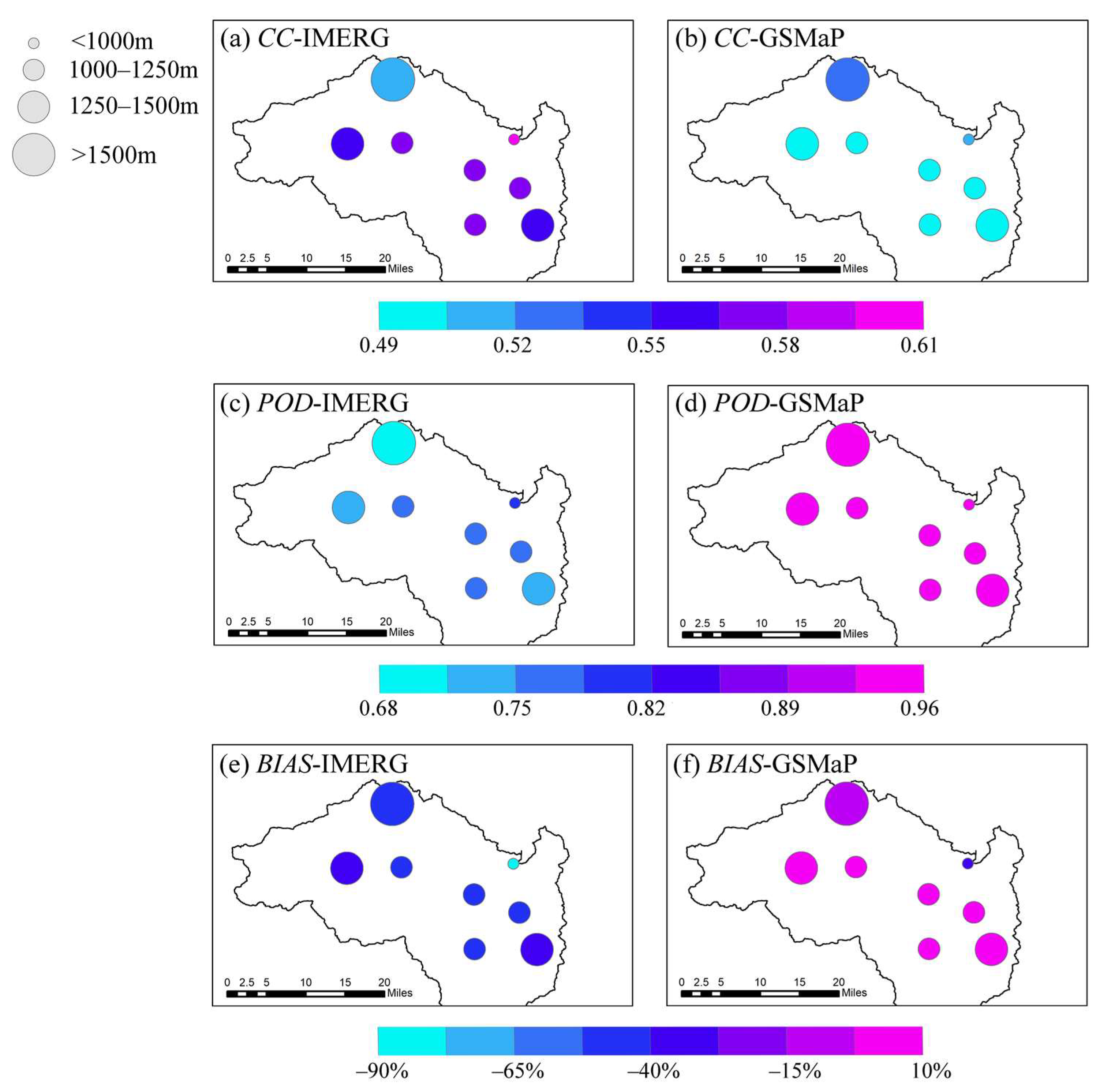
| Gauge | CC | BIAS (%) | RMSE (mm/d) | |||
|---|---|---|---|---|---|---|
| IMERG | GSMaP | IMERG | GSMaP | IMERG | GSMaP | |
| Kuhao | 0.52 | 0.53 | −43.5 | −3.6 | 16.48 | 11.66 |
| Jinshan | 0.55 | 0.40 | −13.7 | 26.0 | 16.69 | 14.61 |
| Sanhe | 0.58 | 0.57 | −55.1 | −5.3 | 15.18 | 10.14 |
| Luchi | 0.52 | 0.44 | −42.8 | 6.3 | 16.19 | 12.49 |
| Datongqiao | 0.39 | 0.54 | −48.3 | 3.1 | 18.95 | 11.72 |
| Shizi | 0.56 | 0.42 | −48.4 | 1.7 | 16.80 | 14.04 |
| Siping | 0.58 | 0.59 | −48.8 | −3.5 | 16.54 | 10.58 |
| Yingjing | 0.61 | 0.51 | −89.6 | −27.9 | 17.02 | 12.28 |
| Whole catchment | 0.54 | 0.50 | −48.8 | −0.4 | 16.73 | 12.19 |
| Gauge | POD | FAR | CSI | HSS | FOH | |||||
|---|---|---|---|---|---|---|---|---|---|---|
| IMERG | GSMaP | IMERG | GSMaP | IMERG | GSMaP | IMERG | GSMaP | IMERG | GSMaP | |
| Kuhao | 0.68 | 0.94 | 0.23 | 0.26 | 0.26 | 0.32 | 0.77 | 0.74 | 0.57 | 0.71 |
| Sanhe | 0.73 | 0.94 | 0.19 | 0.22 | 0.30 | 0.37 | 0.81 | 0.78 | 0.62 | 0.75 |
| Siping | 0.76 | 0.94 | 0.21 | 0.26 | 0.34 | 0.33 | 0.79 | 0.74 | 0.63 | 0.71 |
| Datongqiao | 0.72 | 0.94 | 0.24 | 0.21 | 0.17 | 0.41 | 0.76 | 0.79 | 0.59 | 0.75 |
| Yingjing | 0.80 | 0.96 | 0.27 | 0.30 | 0.35 | 0.37 | 0.73 | 0.70 | 0.62 | 0.68 |
| Luchi | 0.76 | 0.90 | 0.19 | 0.16 | 0.08 | 0.29 | 0.81 | 0.84 | 0.64 | 0.77 |
| Jinshan | 0.76 | 0.91 | 0.15 | 0.13 | 0.16 | 0.35 | 0.85 | 0.87 | 0.66 | 0.80 |
| Shizi | 0.79 | 0.93 | 0.21 | 0.21 | 0.23 | 0.34 | 0.79 | 0.79 | 0.65 | 0.74 |
| Whole catchment | 0.75 | 0.93 | 0.21 | 0.22 | 0.24 | 0.35 | 0.79 | 0.78 | 0.62 | 0.74 |
| The Dependent Variable | Satellite Rainfall Data | Regression Model |
|---|---|---|
| CC | IMERG | CC = 0.123 − 0.303a − 0.221b − 0.005c |
| GSMaP | CC = 0.216 − 0.144a − 0.119b − 0.009c | |
| POD | IMERG | POD = 0.337 − 0.410a − 0.243b − 0.012c |
| GSMaP | POD = 0.512 − 0.251a − 0.210b − 0.011c |
| Topography Factors | CC | POD | BIAS (%) | ||||
|---|---|---|---|---|---|---|---|
| IMERG | GSMaP | IMERG | GSMaP | IMERG | GSMaP | ||
| Elevation (m) | <1000 | 0.61 | 0.51 | 0.80 | 0.96 | −89.62 | −27.90 |
| 1000–1250 | 0.57 | 0.50 | 0.76 | 0.93 | −47.09 | 1.90 | |
| 1250–1500 | 0.56 | 0.49 | 0.74 | 0.93 | −34.41 | 10.35 | |
| >1500 | 0.52 | 0.53 | 0.68 | 0.94 | −43.54 | −3.60 | |
| Slope (°) | <10° | 0.65 | 0.61 | 0.82 | 0.95 | −69.20 | −15.70 |
| 10°−20° | 0.54 | 0.42 | 0.77 | 0.91 | −35.00 | 11.30 | |
| 20°−30° | 0.49 | 0.56 | 0.73 | 0.94 | −51.70 | −1.10 | |
| >30° | 0.52 | 0.53 | 0.68 | 0.94 | −43.50 | −3.60 | |
| Topography Aspect | Satellite Rainfall Data | Regression Coefficient | ||
|---|---|---|---|---|
| CC | POD | BIAS | ||
| Elevation | IMERG | −0.94 | −0.95 | 0.14 |
| GSMaP | −0.62 | −0.52 | 0.11 | |
| Slope | IMERG | −0.81 | −0.98 | 0.23 |
| GSMaP | −0.58 | −0.21 | 0.19 | |
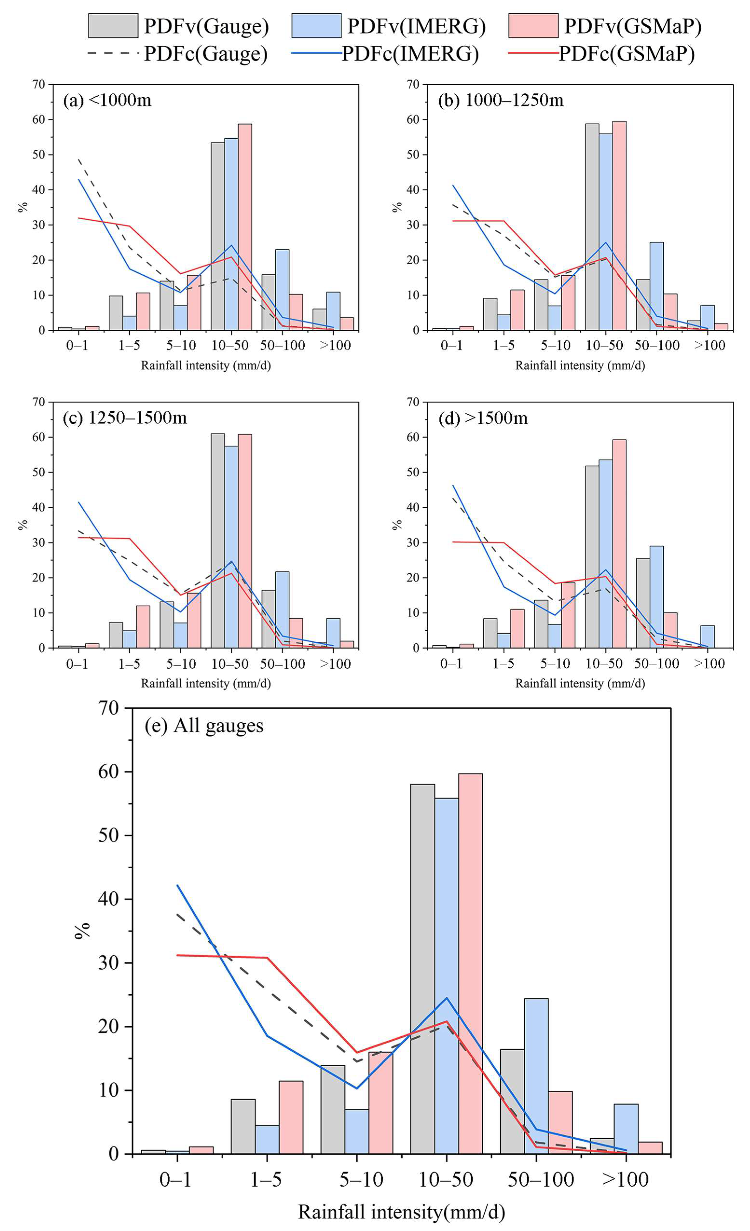
| Elevation Range (m) | Rainfall Intensity (mm/d) | PDFc (%) | PDFv (%) | ||||
|---|---|---|---|---|---|---|---|
| Gauge | IMERG | GSMaP | Gauge | IMERG | GSMaP | ||
| <1000 | 0–1 | 48.6 | 42.9 | 32.0 | 0.8 | 0.4 | 1.1 |
| 1–5 | 23.6 | 17.5 | 29.7 | 9.8 | 4.1 | 10.7 | |
| 5–10 | 11.3 | 10.8 | 16.1 | 14.0 | 7.0 | 15.7 | |
| 10–50 | 14.9 | 24.2 | 20.9 | 53.5 | 54.6 | 58.7 | |
| 50–100 | 1.3 | 3.7 | 1.2 | 15.9 | 23.0 | 10.2 | |
| >100 | 0.3 | 0.9 | 0.2 | 6.1 | 10.9 | 3.7 | |
| 1000–1250 | 0–1 | 35.7 | 41.3 | 31.1 | 0.5 | 0.5 | 1.1 |
| 1–5 | 27.0 | 18.7 | 31.1 | 9.1 | 4.4 | 11.5 | |
| 5–10 | 15.2 | 10.4 | 15.7 | 14.4 | 7.0 | 15.6 | |
| 10–50 | 20.3 | 25.0 | 20.7 | 58.8 | 55.9 | 59.5 | |
| 50–100 | 1.6 | 4.0 | 1.1 | 14.4 | 25.1 | 10.4 | |
| >100 | 0.2 | 0.5 | 0.1 | 2.7 | 7.1 | 1.9 | |
| 1250–1500 | 0–1 | 33.3 | 41.5 | 31.5 | 0.5 | 0.4 | 1.2 |
| 1–5 | 24.8 | 19.5 | 31.2 | 7.3 | 4.9 | 12.0 | |
| 5–10 | 15.4 | 10.3 | 15.1 | 13.1 | 7.1 | 15.6 | |
| 10–50 | 24.3 | 24.7 | 21.3 | 61.0 | 57.4 | 60.8 | |
| 50–100 | 2.0 | 3.4 | 0.9 | 16.4 | 21.7 | 8.4 | |
| >100 | 0.1 | 0.7 | 0.1 | 1.7 | 8.4 | 2.0 | |
| 1500> | 0–1 | 42.6 | 46.3 | 30.2 | 0.7 | 0.2 | 1.1 |
| 1–5 | 24.6 | 17.4 | 30.0 | 8.3 | 4.2 | 11.0 | |
| 5–10 | 13.3 | 9.3 | 18.4 | 13.6 | 6.7 | 18.6 | |
| 10–50 | 16.8 | 22.3 | 20.3 | 51.8 | 53.6 | 59.3 | |
| 50–100 | 2.7 | 4.2 | 1.1 | 25.5 | 29.0 | 10.0 | |
| >100 | 0.0 | 0.4 | 0.0 | 0.0 | 6.4 | 0.0 | |
| All gauge | 0–1 | 37.6 | 42.2 | 31.2 | 0.6 | 0.4 | 1.1 |
| 1–5 | 25.7 | 18.6 | 30.8 | 8.6 | 4.5 | 11.4 | |
| 5–10 | 14.5 | 10.3 | 15.9 | 13.9 | 7.0 | 16.0 | |
| 10–50 | 20.2 | 24.5 | 20.8 | 58.0 | 55.9 | 59.7 | |
| 50–100 | 1.8 | 3.9 | 1.1 | 16.4 | 24.4 | 9.8 | |
| >100 | 0.2 | 0.6 | 0.1 | 2.4 | 7.8 | 1.9 | |
Disclaimer/Publisher’s Note: The statements, opinions and data contained in all publications are solely those of the individual author(s) and contributor(s) and not of MDPI and/or the editor(s). MDPI and/or the editor(s) disclaim responsibility for any injury to people or property resulting from any ideas, methods, instructions or products referred to in the content. |
© 2023 by the authors. Licensee MDPI, Basel, Switzerland. This article is an open access article distributed under the terms and conditions of the Creative Commons Attribution (CC BY) license (https://creativecommons.org/licenses/by/4.0/).
Share and Cite
Tang, X.; Li, H.; Qin, G.; Huang, Y.; Qi, Y. Evaluation of Satellite-Based Precipitation Products over Complex Topography in Mountainous Southwestern China. Remote Sens. 2023, 15, 473. https://doi.org/10.3390/rs15020473
Tang X, Li H, Qin G, Huang Y, Qi Y. Evaluation of Satellite-Based Precipitation Products over Complex Topography in Mountainous Southwestern China. Remote Sensing. 2023; 15(2):473. https://doi.org/10.3390/rs15020473
Chicago/Turabian StyleTang, Xuan, Hongxia Li, Guanghua Qin, Yuanyuan Huang, and Yongliang Qi. 2023. "Evaluation of Satellite-Based Precipitation Products over Complex Topography in Mountainous Southwestern China" Remote Sensing 15, no. 2: 473. https://doi.org/10.3390/rs15020473