Article

Colocation in Time and Space of High-Precision Two-Way Optical and Microwave Observations for Calibration of a Microwave Ranging Link—The ACES Mission Case

Forschungseinrichtung Satellitengeodaesie, Technical University of Munich, 80333 Munich, Germany
*
Author to whom correspondence should be addressed.
Remote Sens. 2023, 15(20), 4897; https://doi.org/10.3390/rs15204897
Submission received: 3 August 2023 / Revised: 25 September 2023 / Accepted: 5 October 2023 / Published: 10 October 2023

Abstract

:
The ACES mission of the European Space Agency combines optical and microwave-based geodetic observation techniques with highly accurate atomic clocks to achieve a new level of accuracy for geodesy and fundamental physics applications. In addition, the combination of two high-precision measurement techniques provides an even more exciting insight into their errors. Fundamental physics is particularly interested in experiments that require high precision between the results of the successive passes of a satellite. An example of such an experiment is the determination of gravitational redshift. Geodesy applications, in contrast, require both high accuracy and precision. Especially for applications like precise ranging or time synchronization, all possible error influences must be characterized and determined with high precision. Therefore, electronic delays of microwave link terminals pose a challenge to achieving high accuracy. They must, therefore, be calibrated, and the stability of the electronic delays must be monitored. While optical observation techniques can be calibrated sufficiently on the ground, the calibration of microwave measurements before a launch is not precise enough, and continuous monitoring is also not possible. In this study, four calibration methods were tested, all based on colocating optical and microwave measurements onboard a satellite and on the ground. The results of two methods achieved the required accuracy of 100 ps for time synchronization, with a mean error and standard deviation of better than 4 ps and 55 picoseconds, respectively. Correlations between the measured parameters were identified, and the impact of the different approaches on accuracy was investigated. It will be shown that the satellite-based colocation of two different geodetic observation techniques has clear advantages, and the calibration results achieved the required accuracy for geodetic applications in this simulation study.

1. Motivation

Increasing accuracy requirements for space geodetic measurements demand the highest levels of precision. However, these are limited by time delays in electronic components. Such undetected delays affect the measurements of individual geodetic observation systems and make it challenging to achieve predefined accuracy targets. An example of such an accuracy target is the required 1 mm accuracy for a future reference frame specified by the International Association of Geodesy (IAG) in the context of a Global Geodetic Observing System (GGOS) [1]. To achieve this, the calibration of the electronic delays in the components seems essential. However, the self-calibration of techniques such as GNSS is more challenging, with various assumptions and limitations ([2,3]). The spatial and temporal colocation of geodetic observations is a promising approach for calibrating microwave-based techniques. Colocation and calibration based on optical observations are suitable for two main reasons. First, tropospheric delays can be minimized relatively well in optical observations. The wet part of the troposphere has almost no effect on the signal delay, while the dry part can be modeled with high accuracy. Second, a typical optical observation technique, such as Satellite Laser Ranging (SLR), can be calibrated with sufficient accuracy on the ground. A future satellite mission that is expected to be the first to provide both the temporal and spatial colocation of high-precision optical and microwave-based geodetic observations is the European Space Agency’s (ESA) “Atomic Clock Ensemble in Space” (ACES) mission [4,5]. The ACES mission is therefore used in this paper to evaluate the spatial and temporal colocation of optical and microwave-based observations for calibration. The following section, therefore, only briefly describes the setup, experiments, and objectives of the ACES mission since the focus is on the calibration aspect.

Background

The ACES project, whose hardware will be installed on the Columbus module of the International Space Station (ISS) in 2025 [6], is an opportunity to carry out new experiments in fundamental physics and geodesy with an accuracy and precision that cannot be achieved using traditional space geodetic techniques [7]. This will be made possible by combining a new generation of atomic clocks onboard satellites [8] as well as by colocating several high-precision geodetic observation techniques in time and space. The combination of two high-precision clocks forms the ACES clock. The measurement hardware configuration of the mission consists of an optical link, called the European Laser Timing (ELT) experiment [9], providing one- and two-way measurements, and a microwave link (MWL) providing two-way pseudorange and phase observations. For ELT, the Columbus module of the ISS will be equipped with an optical detector and reflector. The optical detector will allow for one-way measurements in an upward direction. The reflector will be used for two-way optical measurements, constituting nothing other than a classic SLR. In the following, the optical one-way measurements will be referred to as ELT one-way, and the two-way measurements will be referred to as ELT two-way. It is important to distinguish between both two-way observation techniques. Specifically, the round trip approach of ELT two-way involves the transmission of a signal from a ground station to a satellite, where it is reflected before returning to the ground station. In contrast, the MWL two-way link consists of three time-synchronous one-way links: one uplink and two downlinks. The uplink is synchronized with the ground station clock, while the two downlinks are synchronized with the space clock. The difference between the two clocks, therefore, corresponds to the time offset of the two link directions. For accurate time transfer, the MWL hardware setup will ensure a precision of 0.3 ps and an absolute synchronisation of the ground station clocks with an accuracy of 100 ps per ISS pass [10]. The high precision of this mission will facilitate, in addition to time transfer applications, several fundamental physics experiments, like gravitational redshift tests and tests for drift in fundamental constants [10,11]. From a geodetic point of view, this mission offers attractive study opportunities in two main areas. First, it is a ranging application based on two high-accuracy techniques. In particular, comparing two independent ranging techniques and characterizing the different error influences is of great interest. Secondly, the ACES mission is a timing mission with very high accuracy. Especially to meet the requirements of time synchronization, all sources of error must be known and minimized. One of these error sources is the electronic delay in the reception and transmission of the MWL signal at the ground and space stations. In principle, this is just a terminal-specific time delay between the processing of the signal and the generation of a time stamp when the signal is received or transmitted. For precise geodetic applications, the accurate determination of the electronic delay through absolute calibration is also essential. The absence of this information precludes the possibility of achieving the required level of accuracy in absolute time transfer, which is a primary objective in geodetic applications. In contrast, electronic delays play a secondary role in fundamental physics investigations, provided they remain constant between passes. From a physical point of view, it is not the accuracy but the precision that is important because the experiments compare the results of successive passes. Any change in the delays will unavoidably affect both fundamental physics experiments and geodetic applications. It is therefore necessary to find a reliable method for determining electronic delays with minimal variability. This is a challenging task given the difficulty of separating the delay parameters from other sources of error. It should be noted that ELT observations are also subject to electronic delays, both one-way and two-way. However, the advantage here is that these delays can be detected very well, even during the measurements [9,12,13,14]. Therefore, this paper assumes electronic delay-free optical observations. Previous studies have successfully explored the combination of microwave and optical geodetic observations. Thaller et al. conducted one of the pioneering experiments in 2011, where they integrated GNSS and SLR observations through satellite colocations to jointly estimate orbit parameters and improve the precision of SLR- and GNSS-specific parameters [15]. Furthermore, Belli et al. showed that it is possible to calibrate ground station time biases with sufficient accuracy using optical one- and two-way measurements as part of the Time Transfer by Laser Link (T2L2) experiment conducted in 2018 [16]. Furthermore, the Laser Time Transfer experiment of the Shanghai Astronomical Observatory has already demonstrated the added value of a high-precision one-way and two-way optical link combined with a GNSS. Time synchronization between the ground station and the Chinese Beidou GNSS satellites was achieved with a precision of approximately 300 ps [17]. In principle, these concepts can be applied to our calibration problem for the MWL part of the ACES mission, but the situation differs a little. Adding ELT observations will help to decorrelate clock and electronic delay. Additionally, the estimation of a common orbit for all geodetic techniques, based on colocation onboard the ISS, will also reduce the correlation between the radial orbit component and the electronic delay. Using the knowledge disseminated in these experiments, we have developed a calibration strategy that is based on the common orbit approach for all techniques involving colocation onboard the ISS. However, ACES is a future mission of the ESA; for this reason, there are no real observations available yet. In order to still acquire a data set with a sufficient number of observations, we have developed a full-scale simulation software product. This tool has the ability to generate both optical and microwave observations while incorporating errors that closely mirror those found in real data sets. This paper is organized as follows: In Section 2, we introduce the simulator, explain the simulation of the largest error effects, and give a brief overview of the data set generated. Section 3 explains the approach employed to achieve the main goal of this work and the development of a calibration strategy and compares three methods based on this approach. Section 4 explains the functional model needed for parameter estimation, tests it, and characterizes the input errors of the estimation. Section 5 presents and discusses the results, and Section 6 gives a summary of the work and an outlook on further modifications and applications.

2. Simulation

As mentioned above, the ACES mission will not provide observations until 2025 at the earliest. As a consequence, a suitable data set has to be generated in order to develop and test the calibration concept. Past experiments have already shown that efficient and realistic simulation software can aid in the testing of strategies for future missions, improve potential measurement processes with controlled error budgets, and thus provide research opportunities that would otherwise not be feasible. In our case, this has two main advantages. On the one hand, the results can be directly compared with the simulated “truth”, which, in turn, provides a measure of the accuracy of the calibration concept. On the other hand, the influence of each single error parameter or systematic on the final result can be estimated, and correlations can be revealed. The most crucial error contributions to be simulated are those that directly affect an individual observation. These include the propagation delay of an electromagnetic signal through the different layers of the atmosphere, relativistic effects such as the Sagnac or Shapiro effect, errors in orbit modeling, errors in satellite and ground clocks, and electronic delays in the direction of transmission and reception. In addition, error effects strongly influence the colocation of high-precision observation techniques in time and space. These effects are negligible for a single technique but prevent an adequate combination of different measurement techniques in colocation. A high-precision colocation of different observation techniques in time and space is impossible without additional effort. For this purpose, a time distribution system (TDS) must be used at the ground station, as is the case at the Geodetic Observatory Wettzel [18,19]. With a TDS, it is possible to connect several instruments to a station and synchronize them to one clock. However, this is only possible with additional noise and other systematics, which are also modeled. Another source of error that limits the accuracy of sensor fusion is tropospheric fluctuations, which affect each observation differently and cannot be removed via averaging, even with two-way measurements. An incorrect local tie vector is one of the most essential spatial influences on the accuracy of colocation. This describes the geometry of the different geodetic observation techniques relative to each other.

2.1. Simulation Software

We implemented a full-scale simulator with the goal of modeling each systematic and random error as realistically as possible. Therefore, we have taken into account any quantity that increases the error variations to more than 300 fs, which is the targeted uncertainty level for time transfer during a single pass based on the MWL-System [10]. Table 1 gives an overview of the observation-technique-specific parameters and the geodetic techniques for which they are simulated.
Our simulator development process primarily focused on tropospheric and orbital simulation, leading to dedicated subsections in this paper. Nevertheless, some minor error parameters implemented in the simulation software but not covered in a separate chapter will be briefly explained in the following.
Local tie vectors between the observation techniques are measured at regular intervals. These observations give information about the relative positions between the techniques in three dimensions [22]. Since these relative vectors are not error-free in reality and since we fix the ground station coordinates in the calibration process, we introduce an artificial height error of one millimeter in the local ties between the ELT telescope and the MWL antenna. Relativistic effects on the signal are also taken into account. We simulated Shapiro and Sagnac effects of the 1st and 2nd order based on the recommended formulas developed by Blanchet et al. in 2001 [23]. The sum of these effects introduces an error of up to 30 m at low elevations for the ACES mission [24]. In addition, we added pure white noise to the observations, with a magnitude depending on the standard deviations of the observation types. For MWL phase observations, we used 0.2 ps; for MWL pseudorange observations, we used 2 ps; and for ELT observations, we used 37 ps [4,25]. In addition, for calibration, we also needed to simulate the electronic delays in the different signals. Therefore, we simulated one nanosecond as the cumulative delay in transmission and reception in the downlink direction and 0.9 ns in the uplink direction. The magnitudes of these delays are based on typical GNSS values [2] and on the specifications of the calibration accuracy of the MWL system achievable on the ground prior to the mission’s launch.

2.2. Clock and Time Distribution

The ACES and ground station clocks, as well as the time deviation between the ground station instruments introduced by the TDS, were modeled as colored noise processes [4,26,27]. In principle, a clock error is nothing more than a variable’s deviation from a reference time system, which can be described as a composition of different noise processes [26]. Figure 1 shows the composition of the noise for the different clocks.
Allan deviation is very effective in characterizing the influence of the two clocks and the TDS on the measurement time of an average pass (about 420 s). Initially, TDS noise is dominant until the averaging time reaches about 80 s. Then, the noise from the ground station Active Hydrogen Maser (AHM) is dominant. The ground station clock noise does not reach the level of the ACES clock noise until the averaging time reaches about 400 s, which is nearly the duration of an average pass. Thus, the ground station time components are the most important limiting factor for fully exploiting the high accuracy of the ACES clock. Table 2 shows the composition of the noise for the different clocks and the TDS together with the standard deviation used to simulate the noise.
In addition to the noise caused by the TDS, we also simulated an inter-technique time offset on the ground between ELT and MWL on the order of one picosecond.

2.3. Orbit Propagation

A correct and consistent orbit simulation is also important for the development of a calibration strategy to be applied to real observations in the future. This section describes not only the creation of the orbit from which the geometric range is generated in the simulation (hereafter referred to as the true orbit) but also the creation of the orbit that will later serve as an a priori model in parameter estimation (hereafter referred to as the initial orbit). To stay close to reality, it is important to find a correct distinction between these two types of orbits. Simply adding offsets or oscillations to the initial orbit will not suffice. Such a static or periodic error can be removed using an appropriate model during parameter estimation. A realistic error that takes into account various physical forces such as atmospheric drag, gravity, and other effects on the satellite must be introduced. To ensure this, we have defined a workflow within our simulation software based on the publicly available Java toolbox Orekit [28]. For propagation, we used day-wise ISS Two-Line Element (TLE) files from CelesTrak [29] to generate Keplerian parameters for an initial orbit. We could also have used a TLE propagator directly, but this has the disadvantage of causing the satellite to only be modeled as a sphere during propagation. By deriving an initial orbit as an input to a numerical propagator with a Dormand–Prince integrator [30], we were able to use a box wing model, which allows us to model and define much more satellite-specific details. It should be noted that a box wing model is only a very rough approximation of the geometry of the ISS, but it allows us to modify various parameters, giving us more flexibility in creating the initial orbit. To account for physical effects on the satellite, we used the Holmes and Featherstone method [31] to take into account gravity perturbations up to a degree and order of 20. For airdrag, we used the Harris–Priester model [32]. For the orientation of the satellite, we chose a nadir pointing attitude model, which is a standard tool for communications satellites, and propagated the true orbit for one day. To create the initial orbit, we performed an orbit determination (OD) in Orekit to estimate an initial orbit using the true orbit position and velocity as observations. For the OD, we only modified the drag coefficient and the mass of the satellites in the box wing model, leaving the physical models the same. We then performed a second numerical orbit propagation using the Dormand–Prince integrator to generate the initial orbit. A more detailed comparison of the differences between the two types of orbits can be found in Section 4.1.

2.4. Atmosphere

The troposphere is the part of the atmosphere where weather takes place. As a result, this part of the atmosphere is subject to permanent variations, not only in time but also in space. This layer is particularly important because it is very difficult to model and induces a non-negligible delay on the speed of signal propagation. In geodesy, the troposphere is usually divided into wet and dry parts. On the one hand, the dry part is mainly driven by temperature and pressure and causes about 90% of the delay for MWL and nearly 100% for ELT observations. For both techniques, the dry delay can be modeled with sufficient accuracy [33]. The delay contributions for ELT and MWL measurements are mainly similar [34]. The wet part, on the other hand, is affected by water vapor, which makes proper modeling difficult. Water vapor is subject to short time variations and can show large density differences in spatial distribution, even at small spatial scales [34,35,36,37].
Ionosphere-induced delays are simulated using the NeQuickG model, which is a 3D layer model and the official correction model for Galileo satellite single-frequency signals [21]. NeQuickG provides the Slant Total Electron Content (STEC) during the satellite pass through numerical integration along the signal path. Throughout the navigation message, Galileo satellites transmit three α parameters that give information about the daily ionospheric state, particularly with regard to the ionization level [38]. The simulated STECSs are then used to calculate the frequency-dependent influence of the ionosphere on the MWL signals up to the third order based on the International Earth Rotation and Reference Systems Service (IERS) conventions [39]. For second- and third-order calculations, the World Magnetic Model 2020 (WMM) is used [40,41]. Higher-order errors are neglected because their influence on the signal propagation time is less than 0.3 ps in the zenith direction for S-band frequencies [39].

2.4.1. Ray-Tracing Technique

In our simulation software, we modeled the tropospheric influence on the propagation time of the electromagnetic signal using the ray-tracing software RADIATE, developed by Hofmeister et al. at the Vienna University of Technology in 2017 [42]. The advantages of this technique compared to a standard mapping function is that the tropospheric delay is not modeled as an isotropic sphere and anisotropic effects can also be included. Depending on the temporal and spatial resolution of the numerical weather model (NWM) used in the ray-tracing software, even small-scale effects, inversion layers, or directional water vapor density changes can be included. Several global, highly accurate NWMs are now available. In 2017, Kačmařík et al. made a comparison between several tropospheric error correction products and methods to determine the troposphere-induced delay [43]. Tropospheric delays are calculated with different NWMs using ray-tracing techniques and compared with GNSS-determined slant delays. The deviations are in the sub-centimeter range in the zenith, with the ERA-NWM of the European Center for Medium-Range Weather Forecasts (ECMWF), which also includes GNSS observations, showing high agreement [43]. Therefore, a simulation based on the ERA-NWM would be useful for modeling the propagation delay of an electromagnetic signal caused by the troposphere. There are, however, two points to which attention must be paid. On the one hand, it should be one of the principles of a simulation that the evaluation and modeling of data should be kept strictly separate and that overlaps should be avoided as much as possible. On the other hand, the goal is to avoid having to adapt the developed calibration method later when using real observational data. Therefore, we decided to use the Vienna Mapping Function 3 (VMF3) [36] for the MWL observations and the Vienna Mapping Function 3—Optical (VMFo) [34] for the ELT observations for parameter estimation; these techniques are currently the state-of-the-art methods in post-processing. However, these correction products are based on the ECMWF ERA-NWM, and this would prevent separation between modeling and evaluation. Therefore, we used the GFS-Analysis NWM developed by the National Oceanic and Atmospheric Administration (NOAA) [20] as an input for ray tracing; this tool also shows good agreement when compared with tropospheric zenith delays estimated from GNSS observations [43]. In addition to the agreement with GNSS, the model characteristics also meet the other requirements for a proper simulation. GFS-NWM has a global spatial resolution of 0.25 (28 km at the equator) and a temporal resolution of 6 h, starting at midnight [20]. For the ACES mission simulation, a higher resolution in the spatial domain is more important than one in the time domain due to the fact that an average ISS pass has a duration of about 6 min.

2.4.2. Turbulence

The simulator already presented by Vollmair et al. [25] was extended due to the possibility of tropospheric fluctuation generation. Tropospheric fluctuations with very high temporal variation must not be neglected [44]. Even an hourly resolution of an NWM is not sufficient for this. The wet part of the troposphere especially is subject to strong short-term variations. In particular, wind generates varying degrees of small-scale turbulence in the different layers of the atmosphere. These so-called eddies cause density variations in small regions of the atmosphere. As a result, an electromagnetic wave does not experience a homogeneous delay but rather a location-dependent delay along the path of propagation [45,46]. In addition, the length and direction of the path also change due to a variation in the refraction coefficient in each density packet. Especially for high-precision applications, this turbulence cannot be neglected, as its error influence can amount to several millimeters [47]. To develop a realistic calibration strategy, these small variations must also be taken into account in modeling. The signal propagation speed, which varies from epoch to epoch, appears similar to noise in observations. Furthermore, these tropospheric variations occur for both ELT and MWL observations. However, the difference is that the variations for optical signals are mainly caused by the dry part and, for microwave signals, the wet part of the troposphere. In 2016, Böhm et al. presented a method for simulating variations in tropospheric wet delays for microwave signals [48], which we have also integrated into our simulation software. This approach is mainly based on the turbulence theory of Treuhaft and Lany [49] and was implemented according to the instructions provided by Nilsson et al. in 2007 [47]. This method depends on an initial tropospheric zenith wet delay with a proper mapping function m, the structure constant C n (2.4), the saturation length scale L, and the wind speed v as input parameters [47]. The modeling of optical turbulence was based on Prochazka’s 2010 publication [50]. In this work, it was possible to measure the influence of tropospheric turbulence on different laser frequencies for the first time. The measured changes in delay even reached several centimeters [50]. The analysis was based on a model developed by Gardner et al. [51] used to determine exact fluctuations. With the appropriate assumptions about the values of various parameters, the approach used in Prochazka’s work can also be used for simulations. These parameters are the initial tropospheric zenith dry delay with the appropriate mapping function m, the structure constant C n (from the Hufnagel–Valley model [52]), the outer scale of the turbulence L 0 , the wavelength of the laser λ , the optical wave number κ , and the one-way target distance L as input parameters [50]. As mentioned above, the effect of tropospheric fluctuations on an electromagnetic observation is similar to that of colored measurement noise.

2.4.3. Dispersive Effects

Contrary to the general assumption that dispersive effects on microwave signals induced by the troposphere are negligible, Hobiger et al., in 2010, showed that they have to be considered, especially for high-precision applications like ACES [53]. Due to the different frequencies of the MWL downlink and uplink, the cited authors estimated propagation time differences between the two of up to 0.5 ps for low elevations. When differentiating the uplink and downlink observations to obtain a direct clock comparison, a dispersive effect would leave a residual error that would bias the clock difference, which could exceed the required accuracies of the ACES mission for, e.g., time synchronization [10]. In addition, the dispersive effect also causes a problem regarding the minimization of ionospheric influence. The magnitude of the time-of-flight variation of microwave signals depends on the Total Electron Content (TEC) of the atmosphere, which can be determined from two simultaneously transmitted microwave signals. It is possible to determine the TEC along the raypath because signal travel time variation is wavelength-dependent. However, if the troposphere also has a dispersive effect on signals at different frequencies, this will slightly distort the retrieval of the TEC value. For example, in the ACES case, if the uplink is corrected using the TEC value obtained from two downlink measurements, this error will propagate and, in the worst case, double the tropospheric dispersive effect on the uplink signal delay. The TEC value can therefore be biased by up to 0.01 TEC units, which corresponds to a change in propagation time of about 0.07 ps [53]. To account for the tropospheric dispersion effect, we extended our simulation software using a model developed by Liebe in 1989 that describes the propagation of electromagnetic waves in the atmosphere [54]. Following the suggestions in the work by Liebe [54] and Liebe et al. [55], it is possible to calculate the dispersive effect based on different atmospheric parameters such as water vapor, temperature, and air pressure. Furthermore, like Hobiger [53], we followed the International Telecommunication Union—Radiocommunication Sector (ITU-R) recommendations and only considered the influence of dry air and water vapor for microwave signal delay [56].

2.5. Data Set

For the data set generated by the simulation software, we made several basic assumptions, mainly (but not exclusively) concerning the ELT measurement technique. We defined July 2021 as the observation period and the Geodetic Observatory Wettzell as the ground-based station. Measurements were simulated for each ISS pass, where the maximum elevation angle was at least 40 . This value resulted from the definition of a minimum elevation angle for ELT One-Way observations of 30 . For MWL and ELT Two-Way observations, we assumed a minimum elevation of 10 . Furthermore, it was assumed that the weather conditions for ELT observations were optimal for each pass and that these observations could also be made in single-photon mode [9,57]. The electronic delay of the MWL system was assumed to be stable over time and defined as one nanosecond for the downlink and 0.9 ns for the uplink. The sampling rate was 12.5 Hz for microwave, 100 Hz for ELT One-Way, and 300 Hz for ELT Two-Way observations. The assumed detection probability for the ELT observations was 10%. This resulted in 100 passes with an average observation length of about 7 min and an average maximum elevation angle of 65 [25].

3. Calibration Strategy

Least-Squares Adjustment (LSA) is the basis of this calibration strategy. This approach allows for reliable parameter estimation under the use of an appropriate functional model. The functional model is based on the observational Equations for the ACES observational techniques, which allows for the decorrelation of the individual parameters and thus the correct determination of electronic delays.

3.1. Basic Workflow

The correction of the tropospheric influence on ELT observations using the VMFo model, the estimation of a common orbit from ELT and MWL observations, and the estimation of a tropospheric-zenith wet delay for MWL observations will aid in parameter decorellation and electronic delay calibration. The workflow of the calibration process can be divided into three main parts: observation pre-correction, ambiguity correction, and electronic delay estimation. Figure 2 outlines the flow of the entire procedure.
The pre-correction of the observations included, in the case of ELT observations, the correction for the total tropospheric delay using the VMFo model as well as for the relativistic effects. For MWL observations, the relativistic effects and the tropospheric delay (VMF3) were also corrected. In addition, the ionospheric influence was minimized at all frequencies by determining the STEC along the pass with the two downlinks in the S- and Ku-bands. Ambiguity resolution was then performed using the phase and code measurements of the two Ku-band frequencies. The procedure relies solely on the LSA method with “Integer Rounding” and does not require any special approaches due to the low noise level of the MWL technique. During the LSA iteration, model parameters, such as mapping coefficients for tropospheric correction as well as Sagnac and Shapiro effects, were recomputed based on the initial orbit and applied to the observations for each run. The ambiguities, the offset of the clock differences, the offset in the radial and along-track directions of the satellites, the velocity and acceleration in the along-track directions, and wet tropospheric zenith delay were estimated. After the adjustment had converged, we were able to resolve the ambiguities in the phase observations and then combine them with the precorrected ELT measurements to determine the electronic delays. In the main part of the calibration, the model parameters were recalculated and reapplied to the observations in each LSA iteration. The parameters estimated were the electronic delays of the up- and downlink, the offset of the clock differences, the zenith wet delay for the MWL observations, the radial orbit offset, and the offset, velocity, and acceleration in the along-track direction. Both observation techniques were only used for the estimation of the orbit parameters. Table 3 lists the simulated parameters again and shows how they were handled in the LSA process.
In addition to the time synchronization error between the ground-based systems caused by the TDS, the calibration strategy neglected the height error in the local ties as well as the dispersive effect of the troposphere on the MWL observations. Other parameters were either corrected using a model or estimated as described.

3.2. Optimum Approach

Based on the basic workflow, we compared four methods. The first method includes only MWL observations in the uplink and downlink directions, while the last three methods are always performed using a combination of ELT and MWL observations co-located onboard the satellite. These methods differ in the successive addition of different observation techniques and their measurements. The search for the optimal method should also aid in matching the observation and processing techniques with their respective influences on the results. Table 4 gives a brief overview of the approaches tested.
Method 1 is based on MWL observations of the two links only. This means that no electronic delays can be estimated. However, the offset of the clock differences, the short arc orbit parameters, and the zenith wet delay can be estimated. It is interesting to compare the estimated parameters with those obtained using the other methods, especially the orbit parameters and the tropospheric delay. Therefore, this method cannot be used for calibration but should show the difference between a single technique and the combination of several techniques. Method 2 included only the combination of MWL and ELT One-Way observations. The challenge here is the optical one-way minimum elevation of 30 , which leads to fewer observations and probably makes decorellation between the troposphere, orbit, and electronic delay much more difficult. However, it can be thought of as an advantage that for ELT One-Way, as for MWL, the ground and satellite clocks are included equally. This should allow for a better separation of the electronic delay from the clock difference since both cause errors in the radial direction of the satellite. In Method 3, ELT two-way observations are added to the LSA model. Since the MWL system has the same minimum elevation as ELT two-way (10 ), the correlation between these parameters is likely to be better resolved. As mentioned earlier, the estimated common orbit for all measured elevations should provide a more stable estimate of the electronic delays. The remaining correlations are expected mainly between the wet influence of the troposphere on the MWL measurements and the electronic delay. However, the troposphere has an elevation-dependent delay with a minimum at the zenith and a maximum at the horizon, whereas the electronic delay remains the same for each elevation. Thus, the partial derivatives of the functional model differ significantly, which aids in separating the parameters. Method 4 is similar to the previous method but has a special focus on the troposphere. The first two approaches assume an isotropic and homogeneous distribution of the tropospheric delay. This is not the case in reality, where azimuth-dependent changes also occur. These deviations from the isotropic model can be well minimized using gradients [58]. For this purpose, the method was extended to estimate wet gradients in the north–south and east–west directions. In the case of GNSS, satellites are usually located in several azimuthal directions as well as at different elevations, allowing for the characterization of the troposphere. However, it must be assumed that the estimated gradients for the ISS pass geometry do not necessarily reflect the truth and are likely to be affected by orbit and clock parameters. Nevertheless, this method has to be considered and studied for its impact on the calibration process.

4. Assessment of Parameter Estimation

In the process of developing a suitable calibration method, it is necessary to evaluate the most important components of the functional model of the LSA method. In principle, such an evaluation is performed to test how well the assumed models of the individual error sources fit the simulated parameters. On the one hand, it is possible to check whether the partial derivatives of the functional model have been set up correctly and, on the other hand, how much of the error contribution can be removed from the observations. Therefore, we will refer to this validation as “Best Possible” tests because they show how good the results can be in the best case. For this validation, we performed two basic tests, one for the orbit and one for the troposphere estimation, since they have the largest error contributions to the observations.

4.1. Data Set

For the data set generated by the simulation software, we made several basic assumptions, mainly—but not exclusively—concerning the ELT measurement technique. We defined July 2021 as the observation period and the Geodetic Observatory Wettzell as the ground station. Measurements were simulated for each ISS pass, with a minimum culmination elevation of 40 . This value resulted from the definition of a minimum elevation angle for ELT One-Way observations of 30 . For the MWL and ELT Two-Way observations, we assumed a minimum elevation of 10 . Furthermore, we assumed that the weather conditions for the ELT observations were optimal for each pass and that these observations could also be performed in single-photon mode [9,57]. Here, optimal weather refers to the degree of cloud cover, not the state of the troposphere. The effect of cloud cover on optical observations was mitigated here for two reasons: the simulation assumed a constant, time-independent electronic delay, and this study evaluated only single passes. Therefore, measurement gaps due to cloud cover between individual passes were negligible. The electronic delay of the MWL system was assumed to be stable over time and defined as one nanosecond for the downlink and 0.9 ns for the uplink. The sampling rate was 12.5 Hz for microwave, 100 Hz for ELT One-Way, and 300 Hz for ELT Two-Way observations. The assumed detection probability for the ELT observations was 10%. This resulted in 100 passes with an average duration of about 7 min and an average maximum elevation angle of 65 [25].

4.2. A Priori Errors of the LSA Process

Before performing “Best Possible” tests, it was essential to characterize the a priori errors of the LSA method. This allowed us to validate the “Best Possible” results and determine an optimization factor. It also allowed us to assess the appropriateness of the chosen models for simulation and calibration. Large input errors can lead to convergence to local minima during estimation, while errors that are too small can lead to results that are too “good” and subsequently distort the accuracy of the calibration method. Table 5 summarizes the main characteristics of the a priori errors. For this purpose, the differences between the simulation and evaluation model were calculated for all the ISS passes in our dataset.
The difference in the orbit of the satellite during short ISS passes in the lateral direction mainly corresponds to an rms of 3.8 cm. For the radial component, we can see an rms value of up to 8 cm. In addition, the along-track component has an rms of 20.1 cm. Estimating an offset in the radial direction and an offset, velocity, and acceleration in the along-track direction should be sufficient to minimize the influence of orbit differences. The effect of the cross-track component on the calculation is relatively small and can be ignored. However, it can lead to a slightly inaccurate determination of the elevation angle and consequently affect the tropospheric correction to a small degree. The orbit errors then contribute to an elevation-dependent range error. Upon comparing the magnitudes of the tropospheric differences of the two geodetic observation systems, it can be seen that the optical tropospheric delay has smaller differences (with an rms of 0.4 cm) than the microwave measurements (with an rms of 6.6 cm). This is due to the minimal influence of the wet component of the troposphere on the optical signals. However, the dry component dominates and can be effectively modeled by measuring temperature and pressure at the ground station. Conversely, the dry delay of the MWL observations shows a similar order of magnitude but with the wet part of the troposphere acting as the dominant component in terms of signal delay.

4.3. “Best Possible” Test—Orbit

For the evaluation of the orbit parameter estimation, a data set was created that contained only the range between the ground station and the space station as observations. For this evaluation, only the four orbit parameters mentioned above were estimated, namely, offsets in the radial and along-track directions as well as velocity and acceleration only for the along-track direction. As an a priori model, the initial orbit was used, whose generation has already been described in Section 2.2. The general a priori errors of the estimation have already been characterized in Section 4.1. Figure 3 shows the a posteriori errors after the LSA procedure for all the simulated passes, where each line represents one pass.
In Figure 3, the effects of errors in satellite velocity or acceleration remain visible, resulting in a significant change in sign after the satellite culminates. The plot also shows that the a posteriori errors are almost uniformly distributed, with a small offset, which might have been due to non-estimated cross-track errors or discrepancies between the functional model of the LSA process and the simulation. Table 6 provides an overview of the a posteriori residuals and compares them with the a priori errors presented in Section 4.1.
Nevertheless, the influence of orbital errors on range measurements can be reduced to sub-millimeter levels, with a negligible offset of about 0.03 mm, or less than a picosecond. Compared to the a priori errors, the RMS metric improved by a factor of about 1000.

4.4. “Best Possible” Test—Troposphere

To test the achievable accuracy of the tropospheric wet zenith delay estimation, we generated a data set that included, in addition to the range, a complete tropospheric delay simulation. The generated tropospheric delay consists of the isotropic and anisotropic tropospheric influence simulated using the ray-tracing technique, the dispersive influence of the troposphere on the different measurement frequencies, and the tropospheric fluctuations simulated as described in Section 2.3. For the best possible solution, a zenith wet delay, wet gradients in the north–south and east–west directions were then estimated, which not only allowed for the correction of isotropic tropospheric influences with the help of VMF3 but also helped us to minimize the anisotropic part. For estimation, the true orbit was also introduced as an a priori model. Thus, the simulated range is free of orbit errors. Figure 4 shows the a posteriori errors of all passes after the LSA process, where each line represents one pass.
The upper panel of the figure shows a remarkable reduction in the influence of tropospheric effects on the microwave measurements. However, the influence of fluctuations remained the dominant factor, with a small anisotropic component still present. It also shows that the remaining errors for the microwave measurements are almost uniformly distributed with no offset. In contrast, the tropospheric influences on the optical measurements were not estimated, so there was no improvement. Table 7 gives an overview of the a posteriori errors and compares them with the a priori errors presented in Section 4.1.
The RMS of the residuals improved by a factor of 13 between the a priori and a posteriori residuals. In addition, the median decreased to 0.2 mm, and the 25th and 75th percentiles decreased to −1.8 mm and 2.3 mm, respectively. Compared to the a priori errors, the inner 50 percent of the a posteriori residuals almost follows a normal distribution around zero. It can be concluded that the functional model is sufficient for significantly minimizing isotropic and anisotropic errors. The elevation-dependent error was also significantly reduced.

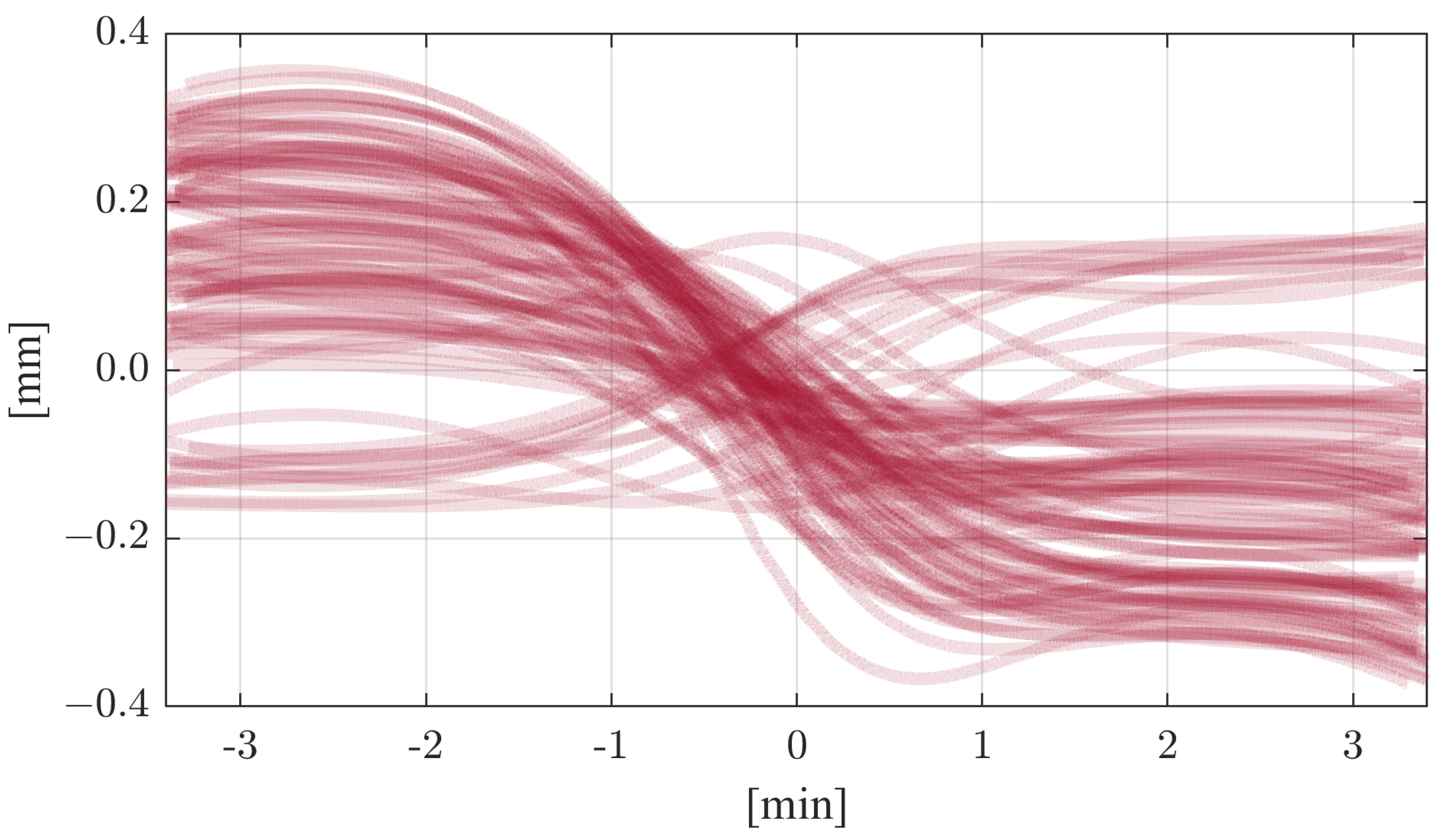
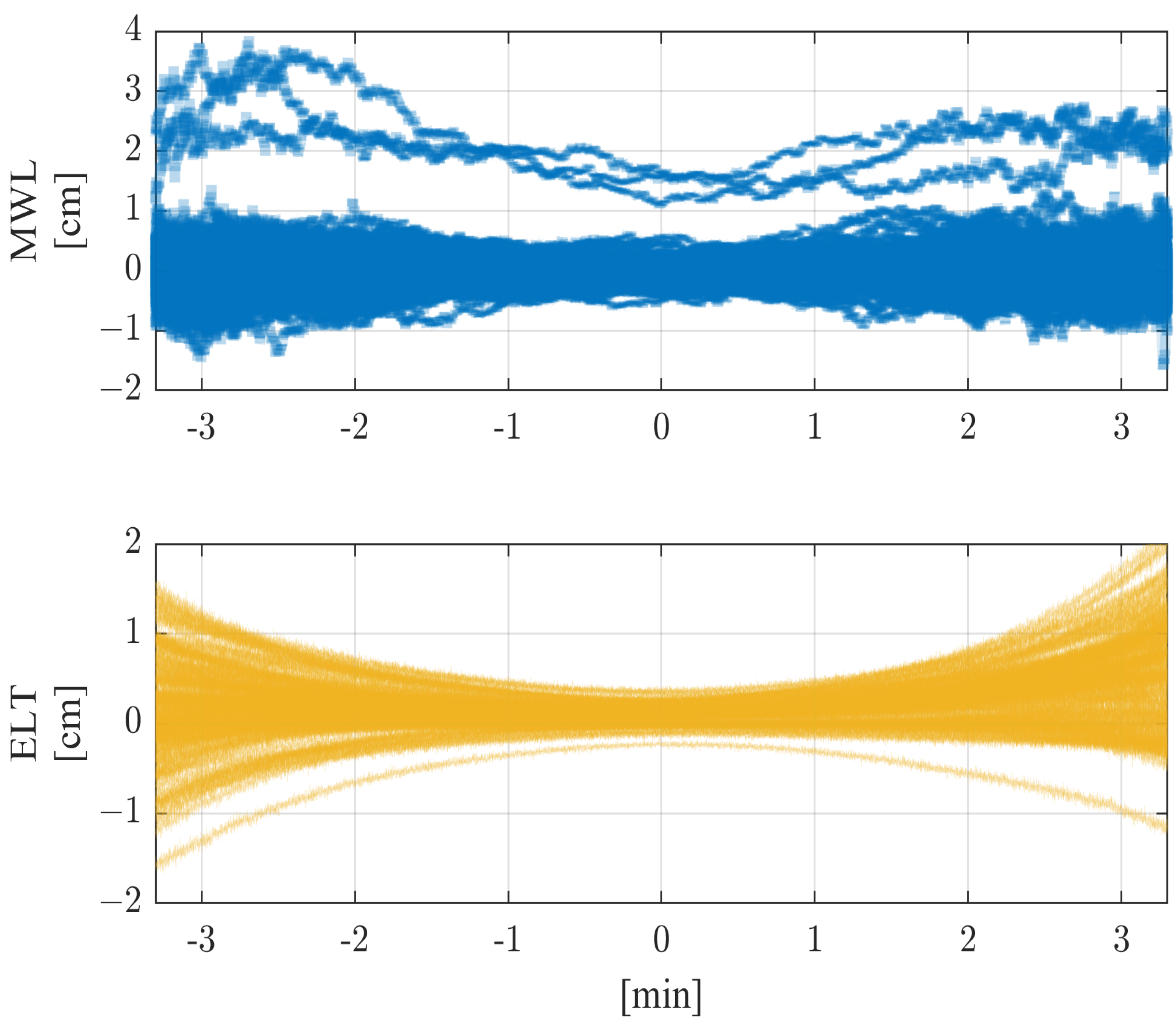
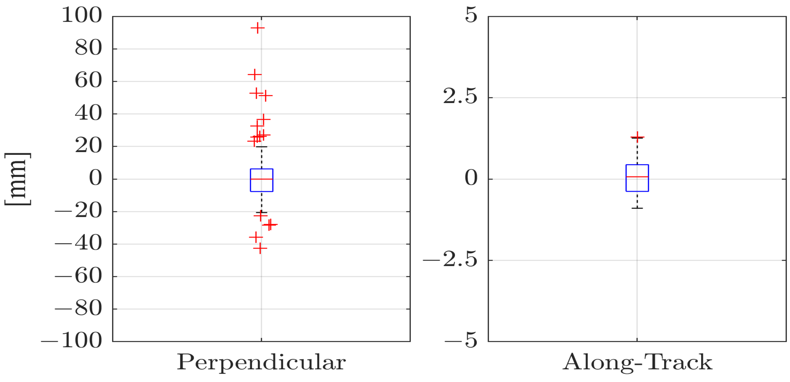
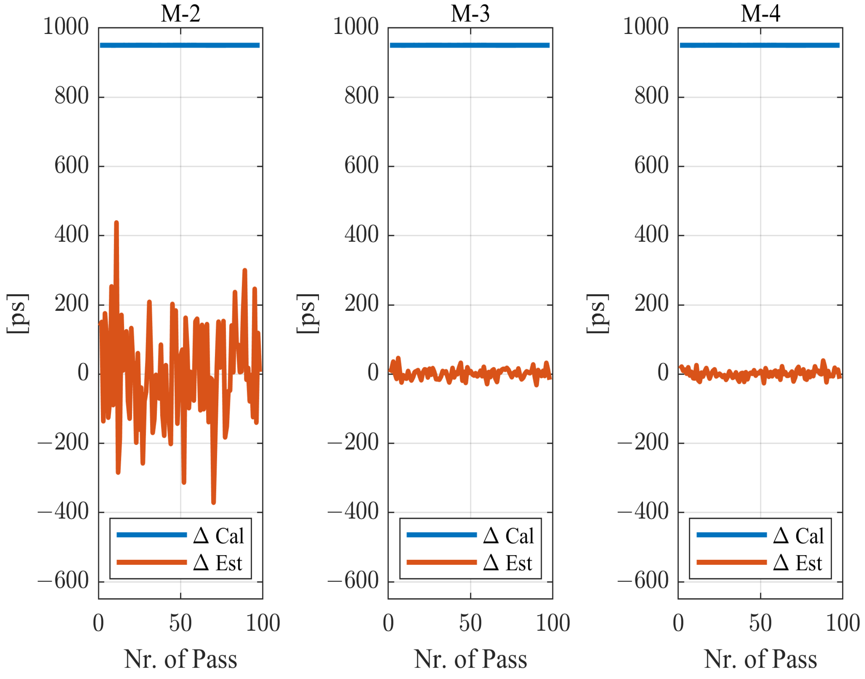
5. Results and Discussion

In this section, we compare the results of the methods for calibrating the MWL two-way system described in Section 3.2. Our comparison shows that one method is optimal. We examine the accuracy of the estimated electronic delays in the uplink and downlink as well as the estimated offset of the clock differences between the satellite and ground clocks as the main criteria of interest. We also analyze and compare the estimated orbit errors and the estimated tropospheric parameters. By comparing these different parameters, we can gain a better understanding of the performance of each calibration method and determine the optimal approach for future use.

5.1. Optimum Approach

As described in Section 3.1, the four methods are based on the same preprocessing strategy and the same approach for phase ambiguity resolution. This ensured that the basis for all the methods was the same. In the first step, ambiguities can be fully resolved due to the low noise level of the code and the phase observations. The deviations between the simulated and estimated ambiguities had a median value of −0.03 cycles for both downlink and uplink phase observations. To resolve the ambiguities, they were rounded to the nearest integer after each iteration of the estimation. However, the main purpose of this section is to evaluate the suitability of the four methods with respect to electronic delay calibration and clock difference offset estimation. Table 8 shows the characteristics of the results obtained using the different methods for all passes. The first section shows the mean of all the differences between the estimated and simulated electronic delays for the downlink and uplink as well as for the offsets of the clock differences between space and ground clocks. The second section shows the mean of the associated formal errors of the LSA process. It should be noted that the formal errors do not directly indicate the accuracy of the results. Instead, they give an indication of how well the functional model fits the observations and how measurement noise influences each estimated parameter.Examining the formal errors of different methods can also indicate which method is preferable. Although small formal errors correspond to small residuals after fitting, they do not necessarily result in better accuracy. In an over-parameterized system, the residuals may also be relatively small. In contrast, the third section of the table shows the calculated standard deviations of the parameter differences between estimation and simulation. The standard deviation together with the mean of the differences, in contrast to the formal errors, allows us to provide a validated statement about precision and accuracy. In contrast to the formal errors, the standard deviation is sensitive to colored noise.
There are significant differences between the calibration results of the four methods. As expected, Method 1 (M-1) shows the most significant deviations between simulation and estimation for the offset of the clock differences between the ground and space, with a mean difference of 950 ps. However, the mean formal error and the standard deviation are the smallest compared to those of the other methods, amounting to 0.08 ps and 0.01 ps, respectively. For Method 2 (M-2), the differences between the estimated and simulated electronic delays show a mean offset of 4.7 ps and 0.7 ps in the downlink and uplink directions. The mean deviation of the estimated offsets of the clock differences is also highest here, amounting to 2.1 ps. This method also stands out clearly when considering the standard deviation. Values of 249 ps, 48 ps, and 143 ps were calculated for the electronic delays in the downlink and uplink directions as well as for the offsets of the clock differences. The mean formal errors are also the largest in this case, with values of 7.1 ps, 2 ps, and 4.2 ps for the sum of the electronic delays in the downlink and uplink directions and the offset of the clock differences. The electronic delays in the downlink direction show by far the largest mean deviation. The results regarding Method 3 (M-3) show smaller differences between the simulated and estimated parameters compared to the second approach. The standard deviations here are 55 ps for the electronic delay in the downlink direction, 29 ps for the uplink direction, and 14 ps for the clock difference offsets. The mean values of the parameter differences are 3.9 ps and 0.8 ps for the electronic delays in the downlink and uplink directions, respectively, and 1.6 ps for the clock difference offsets. In addition, the standard deviation, mean formal error, and mean of the electronic delay differences in the downlink direction decreased significantly. However, the mean value of the electronic delay differences in the uplink direction increased slightly compared to the second method. Method 4 (M-4) shows the highest accuracy and the lowest deviations among the different calibration approaches. In this case, there are significant improvements in both the standard deviation and the mean differences of the parameters. The standard deviations of the estimated electronic delays in the downlink and uplink directions are 49 ps and 27 ps, respectively. For the offsets of the clock differences, the standard deviation is 12 ps. The mean values of the electronic delays in the downlink and uplink directions are 1.3 ps and −0.6 ps, respectively, while the mean value of the offsets of the clock differences is 1.1 ps. The mean formal errors of the parameters are not significantly different from those pertaining to the third method. However, the mean formal errors of the electronic delay in the uplink direction, as well as those of the offsets of the clock differences, slightly improved, while the mean formal error of electronic delays is stable for the downward direction. For comparison, the standard deviations again show a significant improvement over the third method and are the smallest of all four methods. For the downlink electronic delay differences, the characteristics of each method show significant differences, with accuracy and precision improving most significantly from Method 2 to Method 3, where the mean formal error was reduced by about 70%, and the standard deviation was reduced by almost 80%. For Method 4, the standard deviation is even less than 50 ps, which clearly meets the accuracy required for geodetic applications. The mean deviations as well as the mean formal errors of the electronic delays in the uplink direction show little change between the methods. However, when looking at the respective standard deviations, it is evident that there was an improvement of about 40% from Method 2 to Method 3 alone. While there was an improvement from Method 3 to Method 4, it was much smaller. Nevertheless, this is a significant improvement in accuracy, especially with respect to the accuracy specifications required for geodetic applications. The offset of the clock differences shows differences in accuracy between the methods similar to those for the electronic delays in the downlink direction. Again, the largest differences in standard deviation were found when comparing Method 2 and Method 3. The value of the standard deviation decreased by about 90% and is thus—together with the mean value of the deviation of the offset of the clock differences, namely, 1.1 ps—clearly below the required accuracy range. The last two methods fully meet the 100 ps accuracy requirement for time synchronization and thus achieve the geodetic goals.

5.2. Residual Analysis

The objective of this section is to evaluate and compare the four proposed methods and characterize the associated errors. We will examine the effectiveness of each method with respect to meeting the geodetic and fundamental physics accuracy criteria of the ACES mission. In addition, we will examine the pass-to-pass variation of the errors and discuss the implications of these variations for the accuracy and stability of the mission results. To better understand the different calibration techniques and their accuracy, it is necessary to look at the parameter differences as well as the “Observed minus Computed” (OmC) residuals from the LSA process. Figure 5 shows the differences between the simulation and estimation for all passes, where the columns display the parameter differences and OmC residuals of the four methods. Each line in the plots represents one pass. The first two rows reveal the differences in the tropospheric delays and the range, while the last row shows the OmC residuals. This comparison also exhibits apparent differences between the results of the different methods. The error range decreases significantly for troposphere and range from Methods 1 and 2 to Methods 3 and 4. Also, the differences of the third and fourth methods are more densely distributed around zero than those of the first two methods. This indicates that the first and second methods are only conditionally suitable for estimating the remaining parameters.
When estimating the tropospheric delay, the first two methods leave significant residual errors, which can reach values of more than 10 cm for low elevations. In addition, for Method 2, a slight negative offset and an anisotropic part of the tropospheric delay, which was not estimated in this method, can be seen. Method 3 also shows a residual anisotropic part in the differences of the tropospheric delay, but it presents a much smaller error range. For low elevations, maximum errors of 10 cm were obtained. Method 4 improved quality once again. The anisotropic part was significantly reduced due to the gradient estimation, and a maximum error of 8 cm remained for low elevations. The residuals in the range are similar to the tropospheric delay. Method 1 shows differences similar to those for the troposphere but with a negative offset. The error peaks are slightly above −10 cm. This shows that the tropospheric influences compensate for each other with the short-arc orbit after estimation. For Method 2, they partly have an offset of up to 14 cm as well as larger errors at lower elevations, indicating an along-track error. Here, the residuals reach values of up to 21 cm. This method has the most significant differences compared to the others. This is despite the addition of more observations from a second technique. The residuals for the other two methods are significantly smaller and more closely distributed around zero. In particular, for the fourth method, the errors at the beginning and end of the passes are significantly smaller, reaching values of up to 6 cm.
The last row shows the OmC residuals of the LSA process. For each method, the OmC residuals are distributed around zero and have almost no offset. This is due to the estimation of the offset of the clock differences parameter and, for the last three methods, the electronic delay parameters. Due to the correlation between range and the troposphere, the respective contributions largely cancel each other out. At the beginning and end of the pass, the influence of the tropospheric fluctuations is still clearly visible. Since the fluctuations are much stronger at low elevations than at high elevations, the orbit parameters used are not sufficient to minimize this error. The defined functional models cannot compensate for the tropospheric fluctuations, which remain in the residuals and, together with clock and measurement noise, produce their own systematics. At higher elevations, however, the typical curvature of the OmC residuals is largely minimized by the correlation between the orbit and the troposphere. In general, there are no significant differences between the methods, although Method 4 shows that the additional gradient estimation helps to reduce the errors slightly more at lower elevations. As mentioned before, the determination of the true north–south and east–west gradients requires the use of observations from more than one satellite. The estimated gradients are expected to absorb other error contributions, too, and help minimize the overall residuals. To investigate the impact of the additional gradients on parameter estimation, we decomposed the estimated north–south and east–west gradients into their components perpendicular to and along the satellite orbit direction. Figure 6 uses boxplots to show the influence of the estimated gradients on the geometry, both perpendicular to the orbit and along the orbit, for all passes.
It can be seen that the gradient contribution perpendicular to the orbit is dominant, while the contribution along the orbit shows only small values during the passes. The gradient component in the along-track direction is significantly smaller than the perpendicular component, with a maximum of 1.9 mm. This is to be expected, as this component may represent the true tropospheric gradient along the pass. The values of the gradient component in the along-track direction are also close to the magnitude expected from a tropospheric gradient. However, an inspection of the correlation matrix of the LSA parameters reveals strong correlations with the offset and the acceleration of the along-track component of the estimated short-arc orbit correction. One conclusion could be that the along-track component of the gradient also absorbs a part of the along-track short-arc orbit correction, or vice versa. However, this is not a problem in the case of calibration, where the focus is on estimating the electronic delays and the offset of the clock differences. On the other hand, the perpendicular gradient component reaches values of up to 10 cm and thus strongly influences the calibration. The perpendicular component offers the possibility of correcting the mapping function of the isotropic troposphere correction model using its mapping function. This creates a scaling effect that can correct deviations in the mapping function, especially at low altitudes. However, it should also be noted that the perpendicular component is strongly negatively correlated with the zenith wet delay parameter. In summary, estimating gradients in the north–south and east–west directions can minimize, via the along-track and perpendicular components, both the isotropic and anisotropic error of the troposphere correction model. However, this can only be achieved by changing the zenith wet delay or other orbital parameters, thus degrading the accuracy of these parameters. For calibration, however, this method is recommended because the gradient does not correlate with the electronic delays or the offset of the clock differences.

5.3. Time Synchronization Analysis

Calibration of the uplink and downlink electronic delays is a fundamental task. It forms the basis for time synchronization between ground and satellite clocks or between several ground stations. Especially for geodetic applications, an accurate determination of the electronic delay is indispensable since any calibration uncertainty is transferred to the time signal. By fixing the electronic delays, it should be possible to perform time synchronization with much higher accuracy than the required 100 ps. For physical applications, high precision is much more important than high accuracy. With constant electronic delays between successive passes, experiments such as those used to determine gravitational redshift can be carried out without distorting influences. There are two approaches to determining the offset of clock synchronization errors. For geodetic applications, the offset of the differences between the ground and space clocks is estimated for each pass. For physical experiments, the clock difference can be determined directly from MWL uplink and downlink observations. However, ambiguities have to be resolved beforehand, and the ionospheric influence on the signal propagation time has to be minimized. An epoch-wise clock synchronization error can then be calculated for each pass with a so called “X-Configuration”. The difference between the MWL downlink and uplink measurements with the closest receiving times is calculated and then divided by a factor of two to obtain a time signal per epoch. This section aims to compare and evaluate the two approaches to obtain the time signal or offset of the clock differences. To establish a common basis, the MWL phase ambiguities for both approaches were fixed, and the ionospheric influence was minimized using the procedure described above. Figure 7 shows the discrepancies between the calculated and simulated (“Cal”), as well as the estimated and simulated (“Est”), offsets of the clock differences between the ground and space clocks.
The estimated clock difference offsets from Method 1 are very similar to the calculated ones and were not plotted. Both clock difference offsets have a mean deviation from the simulation of about 950.1 ps and a standard deviation of about 0.011 ps for the “Cal” method and 0.009 ps for the “Est” method. The difference between the mean deviation of the two methods is thus negligible. However, the standard deviation indicates that the “Est” method has a smaller variation than that of the “Cal” method. The differences in the estimated offsets from Method 2 are the most variable. They have error variations of up to 440 ps. As shown in Table 8 and discussed earlier, the error spread decreases significantly from Method 2 to Methods 3 and 4. Here, the most significant outliers of 46 ps and 39 ps are smaller by almost a factor of ten. In contrast, the differences in the calculated offsets of the clock differences have a small error spread but a significant offset of 950 ps, which directly derives from the electronic delays in the uplink and downlink directions. This again highlights the differences between the two approaches. The calculated offsets of the clock differences are highly suitable for studying physical effects such as gravitational redshift. In this case, precision is more important than accuracy, the latter of which can be neglected here. However, this requires that the electronic delay is stable throughout the experiment. If this is not the case, drift or other variations in the electronic delays would distort the experiment. For geodetic applications, such as time synchronization, high accuracy is required. Precision also plays a role here, but it is secondary to accuracy. The deviations of the estimated offsets are caused mainly by the pass-by-pass estimation of the electronic delays and thus strongly influence precision. A possible reduction in the error range could be achieved by averaging the estimated electronic delays. Assuming there are stable electronic delays in both the uplink and downlink directions, the averaging of the electronic delays should be sufficiently accurate after a sufficient number of passes. Figure 8 shows the Allan variance of the deviations of the estimated electronic delays in the downlink direction for all passes for Methods 2–4.
We used Allan deviation to determine the minimum number of consecutive passes over which the estimated electronic delays should be averaged. All the methods show approximately the same slope of 1 2 for the first passes, corresponding to white noise. The increase in accuracy for the first passes is to be expected since measurement noise dominates here and can be significantly minimized through averaging. As expected, Methods 3 and 4 gave the best results, although, for Method 4, an average of only 12 consecutive passes should be sufficient to achieve an accuracy of 11 ps for calibration. Interestingly, according to the Allan variance, Method 3 achieves a higher accuracy from 18 consecutive passes than Method 4. After 28 passes, the accuracy is already at 6 ps, while the accuracy of Method 4 is still around 11 ps. This is due to the additional gradient estimation of Method 4. The over-parameterization of the functional model and the resulting strong correlations between some parameters result in flicker noise that dominates after 12 consecutive passes. For a pass-by-pass estimation, therefore, Method 4 is preferable. However, if there are enough consecutive passes, the results obtained for Method 3 can be used to calculate a more accurate mean electronic delay in both link directions. Assuming an average of three passes per day, four consecutive days of cloudless weather should be sufficient to calibrate the microwave link. With a mission duration of several months, the probability of being able to take measurements on four consecutive days is relatively high. This should allow for the determination of the offsets of the time differences between the ground and space clocks with much higher accuracy. For the geodetic approach, the accuracy should increase significantly, and the precision should settle at a high level, similar to the precision of the approach with the calculation of the offset of the clock differences. However, suppose the electronic delays are not stable. In that case, the electronic delays obtained through pass-by-pass estimation will have to be used to calibrate the MWL-Link for each pass. Nevertheless, even this approach is sufficient to perform time synchronization with the desired accuracy of 100 ps.

6. Conclusions

In this work, microwave and optical observations were simulated to investigate several methods for calibrating a microwave ranging system via temporal and spatial colocation. The simulation focused on simulating each parameter as accurately as possible. Tropospheric delays were generated using ray tracing, and tropospheric turbulence was generated using colored noise processes. To disturb the temporal colocation, colored noise was also added to a time distribution system at the ground station. The same method was used to generate both the ground and ACES clocks. Four methods of calibrating a microwave ranging system were investigated on this basis. However, it should be noted that Method 1 is not a calibration method. The idea behind Method 1 was to investigate the accuracy with which the tropospheric influence on signal propagation time and orbit errors can be determined. Method 2 is suitable for the mean parameter differences but has an excessively high standard deviation in the downlink direction. Therefore, the achievement of the objectives cannot be guaranteed. Methods 3 and 4, however, are very suitable for determining electronic delay, with Method 4 achieving a slightly higher accuracy. The use of optical observation techniques in conjunction with microwave observation techniques led to a significant improvement in accuracy and precision. The introduction of gradient estimation in Method 4 artificially increased the degree of correlation. Although this reduces the accuracy of estimating these parameters, it allows the electronic delays to be calibrated to this level of accuracy. As mentioned in Section 5.3, 12 consecutive passes are sufficient to calibrate the MWL terminal to an accuracy of 10 ps. This allows for the potential of the ELT technique to be fully utilized and the electronic delays to be sufficiently calibrated. From a general geodetic perspective, the question arises as to whether it is desirable to develop a method that is not only tailored to individual parameters but also improves the overall accuracy of parameter estimation while minimizing correlations between parameters. Such a method could be based on additional observations or models. In the optical domain, introducing two or more color measurements could contribute to a better decorrelation of the orbit and the troposphere, with an expected increase in accuracy achievable via increasing the number of observations. In addition, improved orbit or troposphere models could be used or developed to better represent the respective parameters. Nevertheless, this study has identified a method capable of determining the electronic delays of an MWL system with sufficient accuracy via colocating it in time and space with a high-precision optical observation technique. The results are primarily valid in the context of this simulation study; they still need to be validated with real data, which will be provided by the ACES mission in 2025.

Author Contributions

Conceptualization, A.S. and P.V.; methodology, P.V. and A.S.; software, P.V.; validation, P.V., A.S. and U.H.; formal analysis, P.V.; investigation, P.V.; resources, U.H.; writing—original draft preparation, P.V.; writing—review and editing, P.V., A.S. and U.H.; visualization, P.V.; supervision, A.S. All authors have read and agreed to the published version of the manuscript.

Funding

This research received no external funding.

Data Availability Statement

The data of this study are available on request.

Conflicts of Interest

The authors declare no conflict of interest.

Abbreviations

The following abbreviations are used in this manuscript:
ACESAtomic Clock Ensemble in Space
AHMActive Hydrogen Maser
CNESCentre national d’études spatiales
ECMWFEuropean Centre for Medium-Range Weather Forecasts
ELTEuropean Laser Timing
ERAECMWF’s new atmospheric reanalysis
ESAEuropean Space Agency
GGOSGlobal Geodetic Observing System
IAGInternational Association of Geodesy
IERSInternational Earth Rotation and Reference Systems Service
ISSInternational Space Station
ITU-RInternational Telecommunication Union—Radiocommunication Sector
LNE-SYRTELaboratoire national de métrologie et d’essais—Système de Références Temps-Espace
LSALeast-Squares Adjustment
MWLMicrowave Link System
NOAANational Oceanic and Atmospheric Administration
NWMNumerical Weather Model
ODOrbit Determination
OmCObserved minus Computed
SLRSatellite Laser Ranging
SHMSpace Hydrogen Maser
STECSlant Total Electron Content
TDSTiming Distribution System
TECTotal Electron Content
TLETwo-Line Elements
VMFoVienna Mapping Function 3—Optical
VMF3Vienna Mapping Function 3

References

  1. Gross, R.; Beutler, G.; Plag, H.-P. Integrated scientific and societal user requirements and functional specifications for the GGOS. In Global Geodetic Observing System: Meeting the Requirements of a Global Society on a Changing Planet in 2020; Springer: Berlin/Heidelberg, Germany, 2009. [Google Scholar]
  2. Montenbruck, O.; Hauschild, A.; Steigenberger, P. Differential Code Bias Estimation using Multi-GNSS Observations and Global Ionosphere Maps. NAVIGATION J. Inst. Navig. 2014, 61, 191–201. [Google Scholar] [CrossRef]
  3. Wang, N.; Li, Z.; Duan, B.; Hugentobler, U.; Wang, L. GPS and GLONASS observable-specific code bias estimation: Comparison of solutions from the IGS and MGEX networks. J. Geod. 2020, 94, 74. [Google Scholar] [CrossRef]
  4. Cacciapuoti, L.; Salomon, C. Space clocks and fundamental tests: The ACES experiment. Eur. Phys. J. Spec. Top. 2009, 172, 57–68. [Google Scholar] [CrossRef]
  5. Nasca, R. Challenging Einstein on the ISS: ACES Takes a Step Ahead. Available online: https://www.esa.int/Enabling_Support/Space_Engineering_Technology/Challenging_Einstein_on_the_ISS_ACES_takes_a_step_ahead (accessed on 23 February 2023).
  6. ACES Workshop 2022. Available online: https://aces2022.sciencesconf.org/ (accessed on 25 October 2022).
  7. Salomon, C.; Cacciapuoti, L.; Dimarq, N. Atomic Clock Ensemble In Space: An Update. Int. J. Mod. Phys. 2007, 16, 2511–2523. [Google Scholar] [CrossRef]
  8. Salomon, C.; Dimarcq, N.; Abgrall, M.; Clairon, A.; Laurent, P.; Lemonde, P.; Santarelli, G.; Uhrich, P.; Bernier, L.G.; Busca, G.; et al. Cold atoms in space and atomic clocks: ACES. Comptes Rendus Acad. Sci. Paris 2001, 2, 1313–1330. [Google Scholar] [CrossRef]
  9. Schreiber, U.; Prochazka, I.; Lauber, P.; Hugentobler, U.; Schafer, W.; Cacciapuoti, L.; Nasca, R. The European laser timing (ELT) experiment on-board ACES. In Proceedings of the 2009 IEEE International Frequency Control Symposium Joint with the 22nd European Frequency and Time Forum, Besancon, France, 20–24 April 2009; pp. 594–599. [Google Scholar]
  10. Atomic Clock Ensemble in Space. Available online: http://wsn.spaceflight.esa.int/docs/Factsheets/20%20ACES%20LR.pdf (accessed on 23 February 2023).
  11. Lilley, M.; Savalle, E.; Angonin, M.C.; Delva, P.; Guerlin, C.; Le Poncin-Lafitte, C.; Meynadier, F.; Wolf, P. ACES/PHARAO: High-performance space-to-ground and ground-to-ground clock comparison for fundamental physics. GPS Solut. 2021, 25, 34. [Google Scholar] [CrossRef]
  12. Kodet, J.; Schreiber, K.U.; Eckl, J.; Ploetz, C.; Maehler, S.; Schueler, T.; Kluegel, T.; Riepl, S. Co-location of space geodetic techniques carried out at the Geodetic Observatory Wettzell using a closure in time and a multi-technique reference target. J. Geodt. 2018, 92, 1097–1112. [Google Scholar] [CrossRef]
  13. Prochazka, I. SLR station biases. In Proceedings of the ILRS Technical Workshop, Matera, Italy, 26–30 October 2015. [Google Scholar]
  14. Prochazka, I.; Kodet, J.; Blazej, J.; Kirchner, G.; Koidl, F.; Wang, P. Identification and calibration of one-way delays in satellite laser ranging systems. Adv. Space Res. 2017, 59, 2466–2472. [Google Scholar] [CrossRef]
  15. Thaller, D.; Dach, R.; Seitz, M.; Beutler, G.; Mareyen, M.; Richter, B. Combination of GNSS and SLR observations using satellite co-locations. J. Geod. 2011, 85, 257–272. [Google Scholar] [CrossRef]
  16. Belli, A.; Exertier, P.; Pavlis, E.C.; Lemoine, F.G. Time bias of laser ranging observations. In Proceedings of the 2017 ILRS Technical Workshop, Riga, Latvia, 2–5 October 2017. [Google Scholar]
  17. Meng, W.; Zhang, H.; Huang, P.; Wang, J.; Zhang, Z.; Liao, Y.; Ye, Y.; Hu, W.; Wang, Y.; Chen, W.; et al. Design and experiment of onboard laser time transfer in Chinese Beidou navigation satellites. Adv. Space Res. 2013, 51, 951–958. [Google Scholar] [CrossRef]
  18. Schreiber, U.; Kodet, J.; Eckl, J.; Herold, G.; Kronschnabl, G.; Plötz, C.; Neidhardt, A. All optical time and frequency distribution for space geodesy. In Proceedings of the 2015 ILRS Technical Workshop, Matera, Italy, 26–30 October 2015. [Google Scholar]
  19. Dominguez, P.N.; Schmidt, T.; Boland, R.; Zeltner, R.; Holzwarth, R.; Klugel, T.; Kodet, J.; Schreiber, U. Pulsed optical timing distribution system with sub-ps accuracy for applications in geodesy. In Proceedings of the ION 2022 Precise Time and Time Interval Systems and Applications Meeting, Long Beach, CA, USA, 25–27 January 2022. [Google Scholar]
  20. NOAA Global Forecast System (GFS). Available online: https://registry.opendata.aws/noaa-gfs-bdp-pds (accessed on 7 March 2023).
  21. Aragon-Angel, A.; Rovira-Garcia, A.; Arcediano-Garrido, E.; Ibáñez-Segura, D. Galileo Ionospheric Correction Algorithm Integration into the Open-Source GNSS Laboratory Tool Suite (gLAB). Remote Sens. 2021, 13, 191. [Google Scholar] [CrossRef]
  22. Kluegel, T.; Maehler, S.; Schade, C. Local ties at the geodetic observatory Wettzell. In Proceedings of the International Workshop on Laser Ranging, Bad Koetzting, Germany, 16–20 May 2011. [Google Scholar]
  23. Blanchet, L.; Salomon, C.; Teyssandier, P.; Wolf, P. Relativistic theory for time and frequency transfer to order c−3. Astron. Astrophys. 2001, 370, 320–329. [Google Scholar] [CrossRef]
  24. Marz, S.; Schlicht, A.; Bamann, C. Relativistic corrections in the European Laser Timing (ELT) experiment. In Proceedings of the 20th International Workshop on Laser Ranging, Potsdam, Germany, 9–14 October 2016. [Google Scholar]
  25. Vollmair, P.; Schlicht, A.; Marz, S.; Hugentobler, U. Combination of microwave and optical observations for minimizing atmospheric induced variations in parameter estimation. In Proceedings of the International Workshop on Laser Ranging, Yebes, Spain, 7–11 November 2022. [Google Scholar]
  26. Kasdin, N.J.; Walter, T. Discrete simulation of power law noise (for oscillator stability evaluation). In Proceedings of the 1992 IEEE Frequency Control Symposium, Hershey, PA, USA, 27–29 May 1992; pp. 274–283. [Google Scholar]
  27. Kasdin, N.J. Discrete simulation of colored noise and stochastic processes and 1/f/sup /spl alpha// power law noise generation. Proc. IEEE 1995, 83, 802–827. [Google Scholar] [CrossRef]
  28. CS Systèmes d’Information. OREKIT. 2018. Available online: https://www.orekit.org/site-orekit-9.2/index.html (accessed on 7 March 2023).
  29. Kelso, T.S. CelesTrak. 2022. Available online: https://celestrak.org/ (accessed on 7 March 2023).
  30. Hairer, E.; Wanner, G.; Nørsett, S.P. Nonstiff problems. In Solving Ordinary Differential Equations I; Springer: Berlin/Heidelberg, Germany, 2008. [Google Scholar]
  31. Holmes, S.A.; Featherstone, W.E. A unified approach to the Clenshaw summation and the recursive computation of very high degree and order normalised associated Legendre functions. J. Geod. 2002, 76, 279–299. [Google Scholar] [CrossRef]
  32. Montenbruck, O.; Gill, E. Satellite Orbits: Models, Methods and Applications; Springer: Berlin/Heidelberg, Germany, 2005. [Google Scholar]
  33. Saastamoinen, J. Atmospheric Correction for the Troposphere and Stratosphere in Radio Ranging of Satellites. Geophy. Monog. Ser. 1972, 15, 247–251. [Google Scholar]
  34. Boisits, J.; Landskron, D.; Boehm, J. VMF3o: The Vienna Mapping Functions for Optical Frequencies. J. Geod. 2020, 94, 57. [Google Scholar] [CrossRef]
  35. Niell, A.E. Global mapping functions for the atmosphere delay at 310 radio wavelengths. J. Geophys. Res. 1996, 101, 3227–3246. [Google Scholar] [CrossRef]
  36. Boehm, J.; Schuh, H. Vienna mapping functions. In Proceedings of the 16th EVGA Working Meeting, Leipzig, Germany, 9–10 May 2003. [Google Scholar]
  37. Boehm, J.; Niell, A.; Tregoning, P.; Schuh, H. Global Mapping Function (GMF): A new empirical mapping function based on numerical weather model data. J. Geophys. Res. 2006, 33. [Google Scholar] [CrossRef]
  38. Ionospheric Correction Algorithm for Galileo Single Frequency Users. Available online: https://www.gsc-europa.eu/sites/default/files/sites/all/files/Galileo_Ionospheric_Model.pdf (accessed on 7 March 2023).
  39. Petit, G.; Luzum, B. IERS Conventions 2010; IERS Technical Note 36; Verlag des Bundesamts für Kartographie und Geodäsie: Frankfurt am Main, Germany, 2010; p. 137. [Google Scholar]
  40. NCEI Geomagnetic Modeling Team and British Geological Survey. World Magnetic Model 2020; NOAA National Centers for Environmental Information; NOAA: Asheville, NC, USA, 2019. Available online: https://www.ncei.noaa.gov/products/world-magnetic-model (accessed on 7 March 2023).
  41. Chulliat, A.; Brown, W.; Alken, P.; Beggan, C.; Nair, M.; Cox, G.; Woods, A.; Macmillan, S.; Meyer, B.; Paniccia, M. The US/UK World Magnetic Model for 2020–2025: Technical Report; National Centers for Environmental Information; NOAA: Asheville, NC, USA, 2020.
  42. Hofmeister, A.; Boehm, J. Application of ray-traced tropospheric slant delays to geodetic VLBI analysis. J. Geod. 2017, 91, 945–964. [Google Scholar] [CrossRef]
  43. Kačmařík, M.; Douša, J.; Dick, G.; Zus, F.; Brenot, H.; Moller, G.; Pottiaux, E.; Kapłon, J.; Hordyniec, P.; Václavovic, P.; et al. Inter-technique validation of tropospheric slant total delays. Atmos. Meas. Tech. 2017, 10, 2183–2208. [Google Scholar] [CrossRef]
  44. Keihm, S.J. Water Vapor Radiometer Measurements of the Tropospheric Delay Fluctuations at Goldstone Over a Full Year. Telecommun. Data Acquis. Prog. Rep. 1995, 122, 1–11. [Google Scholar]
  45. Nilsson, T.; Gradinarsky, L.; Elgered, G. Correlations between slant wet delays measured by microwave radiometry. IEEE Trans. Geosci. Remote Sens. 2005, 43, 1028–1035. [Google Scholar] [CrossRef]
  46. Nilsson, T.; Elgered, G.; Gradinarsky, L. Characterizing atmospheric turbulence and instrumental noise using two simultaneously operating microwave radiometers. In Proceedings of the 2006 IEEE Microrad Proceedings 9th Specialist Meeting on Microwave Radiometry and Remote Sensing Applications: Microrad’06, San Juan, Puerto Rico, 28 February–3 March 2006; pp. 270–275. [Google Scholar]
  47. Nilsson, T.; Haas, R.; Elgered, G. Simulations of atmospheric path delays using turbulence models. In Proceedings of the 18th European VLBI for Geodesy and Astrometry Work Meeting, Vienna, Austria, 12–13 April 2017. [Google Scholar]
  48. Boehm, J.; Wresnik, J.; Pany, A. Simulation of Wet Zenith Delays and Clocks. Available online: https://ivscc.gsfc.nasa.gov/publications/memos/ivs-2006-013v03.pdf (accessed on 7 March 2023).
  49. Treuhaft, R.N.; Lany, G.E. The effect of the dynamic wet troposphere on radio interferometric measurements. Radio Sci. 1987, 22, 251–265. [Google Scholar] [CrossRef]
  50. Prochazka, I.; Kral, L.; Blazej, J. Picosecond laser pulse distortion by propagation through a turbulent atmosphere. In Coherence and Ultrashort Pulse Laser Emission; Duarte, F.J., Ed.; IntechOpen: Rijeka, Croatia, 2010; Chapter 19. [Google Scholar]
  51. Gardner, C.S. Effects of random path fluctuations on the accuracy of laser ranging systems. Appl. Opt. 1976, 15, 2539. [Google Scholar] [CrossRef] [PubMed]
  52. Andrews, L.C.; Phillips, R.L. Laser satellite communication systems. In Laser Beam Propagation through Random Media; SPIE Press: Bellingham, WA, USA, 2005; p. 481. [Google Scholar]
  53. Hobiger, T.; Piester, D.; Baron, P. A correction model of dispersive troposphere delays for the ACES microwave link. Radio Sci. 2013, 48, 131–141. [Google Scholar] [CrossRef]
  54. Liebe, H.J. An atmospheric millimeter-wave propagationmodel. Int. J. Infrared Millim. Waves 2013, 10, 631–650. [Google Scholar] [CrossRef]
  55. Liebe, H.J.; Hufford, G.A.; Cotton, M.G. Propagation modeling of the moist air and suspended water/ice particles at frequencies below 1000 GHz. In Proceedings of the AGARD 52 Meeting, Palma de Mallorca, Spain, 17–21 May 1993. [Google Scholar]
  56. ITU-R Attenuation by Atmospheric Gases and Related Effects Recommendation ITU-R P.676-8. 2009. Available online: https://www.itu.int/dms_pubrec/itu-r/rec/p/R-REC-P.676-8-200910-S!!PDF-E.pdf (accessed on 7 March 2023).
  57. Prochazka, I.; Kodet, J.; Blazei, J.; Koidl, F.; Kirchner, G. SPAD detector package for European Laser Time transfer in space. In Proceedings of the Single Photon Workshop, Boulder, CO, USA, 3–6 November 2009. [Google Scholar]
  58. Chen, G.; Herring, T.A. Effects of atmospheric azimuthal asymmetry on the analysis of space geodetic data. J. Geophys. Res. Solid Earth 1997, 102, 20489–20502. [Google Scholar] [CrossRef]
Figure 1. Allan deviation of ACES and groundstation (AHM) clocks and of TDS [s].
Remotesensing 15 04897 g001
Figure 2. Calibration strategy workflow.
Remotesensing 15 04897 g002
Figure 3. “Best Possible” test—Orbit. A posteriori residuals of 100 passes. Zero minutes at the x-axis corresponds to satellite culmination with respect to the ground station.
Remotesensing 15 04897 g003
Figure 4. “Best Possible” test—Troposphere. Plots showing a posteriori errors of all passes. Zero minutes on the x-axis corresponds to satellite’s culmination with respect to the ground station. MWL a posteriori are shown in blue, ELT a posteriori in yellow.
Remotesensing 15 04897 g004
Figure 5. The columns show the parameter differences and the OmC residuals of the four methods for all passes, where the tropospheric and range differences are presented in the first two rows and the MWL-Downlink OmC residuals are given in the last row. Zero minutes on the x-axis corresponds to the culmination of the satellite with respect to the ground station.
Remotesensing 15 04897 g005
Figure 6. Boxplots of gradient contribution perpendicular to and along the orbit. The blue boxes contains the inner 50 percent of the contribution, where the red crosses show outliers.
Remotesensing 15 04897 g006
Figure 7. In red: pass-wise differences between the estimated and simulated offsets of the clock differences (denoted as Est). In blue: pass-wise differences between the calculated and simulated offsets of the clock differences (denoted as Cal).
Remotesensing 15 04897 g007
Figure 8. The figure shows the Allan deviation of the deviations of the estimated electronic delays in the downlink direction for methods M-2, M-3, and M-4. The units provided are picoseconds.
Remotesensing 15 04897 g008
Table 1. Simulation parameters. Consideration is marked with an X.
ParameterModelMWLELT
TroposphereGFS [20]XX
OrbitTLEXX
IonosphereNeQuickG [21]X-
ClocksColored-NoiseXX
TDS OffsetIntertechnique Offset-X
TDS NoiseIntertechnique Colored Noise-X
Local TiesHeight Offset-X
Sagnac1st & 2nd OrderXX 1
Shapiro-XX
Measurement NoiseWhite NoiseXX
Electronic DelayStaticX-
1 Sagnac effect is only relevant for ELT One-Way, not for Two-Way.
Table 2. Composition of noise for ACES and groundstation clocks as well as TDS and their respective magnitudes at 1 s.
Noise TypeACESGroundTDS
White Phase-- 1 × 10 12
Flicker Phase 1 × 10 13 4 × 10 13 6 × 10 14
White Frequency 1 3 × 10 14 3 × 10 14 -
Flicker Frequency 1 × 10 15 --
Random Walk Frequency- 3 × 10 17 -
1  1 × 10 13 for PHARAO. Other parameters are for SHM only.
Table 3. Observation parameters. Consideration is marked with an X.
ParameterDescriptionLSAModel
Troposphere 1VMF3 and VMFoXX
OrbitCommon short arcX-
IonosphereCorrected via STEC-X
ClocksOffsetX-
SagnacBased on initial orbit-X
ShapiroBased on initial orbit-X
Electronic delaysParameters of interestX-
1 Estimated for MWL, corrected for ELT.
Table 4. Calibration methods. Consideration is marked with an X.
MethodMWLELT One-WayELT Two-WayWet-Gradient 1
1X---
2XX--
3XXX-
4XXXX
1 MWL only.
Table 5. Characteristics of a priori errors [cm].
Parameter25th PercentileMedian75th PercentileRMS
Radial1.054.838.327.97
Along-Track6.2416.9326.3720.58
Cross-Track−3.392.433.953.85
Range−14.23−1.4813.7017.46
Trp-ELT0.060.190.370.42
Trp-MWL1.012.936.036.58
Ion-Down−0.001−0.000060.0010.002
Ion-Up−0.0020.000090.0020.002
Table 6. Characteristics of a priori and a posteriori errors [cm].
Range25th PercentileMedian75th PercentileRMS
a priori−14.235−1.47513.70317.461
a posteriori−0.014−0.0030.0120.017
Table 7. Characteristics of MWL a priori and a posteriori tropospheric errors [cm].
Troposphere25th PercentileMedian75th PercentileRMS
a priori1.012.936.036.58
a posteriori−0.180.020.230.49
Table 8. Characteristics of the electronic delay differences in the downlink and uplink directions as well as the clock differences of all passes. The means and standard deviations were calculated from the differences between the estimated and simulated parameters. The formal errors shown are the means of all formal errors from the least squares adjustment of each method. The units used are picoseconds [ps].
MeanMean Formal ErrorsStandard Deviation
ParameterM-1M-2M-3M-4M-1M-2M-3M-4M-1M-2M-3M-4
Downlink-4.73.91.3-7.12.02.0-2495549
Uplink-0.70.8−0.6-2.01.71.5-482927
Clock9502.11.61.10.084.21.71.50.011431412
Disclaimer/Publisher’s Note: The statements, opinions and data contained in all publications are solely those of the individual author(s) and contributor(s) and not of MDPI and/or the editor(s). MDPI and/or the editor(s) disclaim responsibility for any injury to people or property resulting from any ideas, methods, instructions or products referred to in the content.

