Article

Effects of Irrigation Projects on the Classification of Yellow River Terrace Landslides and their Failure Modes: A Case Study of Heitai Terrace

1
School of Earth Sciences, Lanzhou University, Lanzhou 730000, China
2
Technology & Innovation Centre for Environmental Geology and Geohazards Prevention, Lanzhou 730000, China
3
College of Earth Environmental Sciences, Lanzhou University, Lanzhou 730000, China
*
Author to whom correspondence should be addressed.
Remote Sens. 2023, 15(20), 5012; https://doi.org/10.3390/rs15205012
Submission received: 18 September 2023 / Revised: 14 October 2023 / Accepted: 16 October 2023 / Published: 18 October 2023
(This article belongs to the Section Remote Sensing in Geology, Geomorphology and Hydrology)

Abstract

:
The study of the classification and failure modes of Yellow River terrace landslides under the influence of irrigation projects is of key importance to alleviate the paradox between the rapid evolution of terrace landscapes caused by landslides and the survival of local residents. However, such studies remain controversial, despite it being widely recognized that a rise in groundwater level caused by irrigation is a key factor associated with landslide failure modes. In this paper, we take the Heitai terrace as a case study. Using aerial images and field investigations, we classify landslides in the Heitai loess layer into type A landslides (not related to groundwater) and type B1 and B2 landslides (related to groundwater). We analyze the failure modes and disaster-causing characteristics of each type of landslide, and our results indicate that the attenuation in soil strength is a key factor common to both type A and type B landslides, based on which type A landslides with small volume and short sliding distance are able to block the previous spring discharge, causing a rise in localized groundwater, which further contributes to type B landslides; the location of previous type B1 landslides with a large volume and long sliding distance and type A landslides may be more susceptible to type B2 landslides with a small volume and short sliding distance, where there are low confining pressures during the lower soil shear process. Therefore, we believe that the inevitable interaction effects between the failure modes of landslides during landslide evolution, which govern the geomorphological evolution of the Heitai terrace, are unavoidable. Combining these data with numerical analyses, we further demonstrate that a rise in groundwater level and discontinuous attenuation of soil strength caused by changes in soil properties during irrigation together control terrace landslides and their failure modes. From the results of interferometric synthetic aperture radar time-series monitoring of Yellow River terrace activity with and without irrigation projects, and electrical resistivity tomography groundwater detection, we conclude that in the future, Heitai terrace will continue to experience a high intensity of landslide activity, and conditions for the most catastrophic type of landslide (type B1) will remain, including the high localized groundwater caused by previous landslides, and the discontinuous attenuation of soil strength caused by the deterioration in soil properties. In this context, we believe that slope-cutting engineering will be one of the most economical means to achieve future landslide-type transformation on the Heitai terrace; this will mitigate the process of geomorphological evolution and improve the human living environment.

1. Introduction

The classification of landslides and their failure modes on the Loess is a long-term research objective [1,2,3,4,5,6], which is of importance to engineering construction, socioeconomics, the ecological environment, and human wellbeing. Currently, the classification and failure modes of loess-related landslides on the Loess Plateau are governed by geological and geomorphological units, tectonic stresses, and climate at the regional scale [7,8]. At the slope scale, landslide failure modes are governed by structural surfaces and bodies formed as a result of various stress components. The structural surfaces include primary joints, tectonic joints, and unconformity surfaces, while the structural bodies comprise blocks formed by the division of different structural surfaces. In addition, major engineering activities construction in loess areas [9,10,11], such as gully consolidation and tableland protection, influence landslide failure modes at the slope scale under engineering disturbances that include pile loading, unloading, and vibration [8,12,13]. In most cases, the classification of loess landslides is based on the failure mechanism, location of the failure surface, and post-failure movement behavior [2,4,14,15,16].
The Yellow River terraces are a widespread geomorphological unit within the Loess Plateau region; they were formed by the Yellow River and its tributaries under the influence of the Tibetan Plateau uplift and climate change [17,18]. In most cases, Yellow River terraces have a low, gently undulating topography, and provide one of the main subsistence sites for the local population. These terraces are more elevated than the modern riverbed and have virtually no lateral recharge from the adjacent river; hence, irrigation projects have been carried out on terrace platforms to provide water for domestic and agricultural use. A typical case of this occurs on the Heitai terrace in Gansu Province, where the groundwater level has risen by >20 m [19] over six decades of agricultural irrigation, and >140 loess-related landslides have occurred during this irrigation period, averaging 3–5 per year, including both loess-bedrock planar slide and loess landslides (Figure 1). However, prior to extensive surface flood irrigation, there were few loess-related landslides on the platform (Figure 1a). In addition, in contrast to non-irrigated Yellow River terraces, there has been a rapid evolution of the landscape caused by frequent landslides over a short period of time on and around the Heitai terrace; this has had a detrimental effect on the livelihoods of Heitai residents via the destruction of fertile farmland, factories, houses, and roads, and an overall reduction in areas suitable for habitation, engineering construction, and cultivation. Studying the effects of the Heitai terrace irrigation project on the classification and failure modes of loess landslides provides a typical case study for the overall classification system of landslides on the Loess Plateau. In addition, such studies can contribute to the improved engineering management of Yellow River terrace landslides associated with irrigation projects. The current classification of landslides in the Heitai terrace region is mainly based on the location and development morphology of failure surfaces, movement characteristics, and the relationship between the main slip direction and inclination of the rock strata; the main failure modes have been discussed in Xu et al. [15], Peng et al. [20,21] and Liu et al. [22]. However, there are insufficient contributions to analyze landslide failure modes based on the triggering factors of landslides and to comprehend landslide classifications.
Previous studies have generally concluded that the occurrence of loess landslides in the Heitai is dependent on the rise of groundwater [23,24,25,26]. In fact, approximately 28% of the landslides that occurred in the early phases of the Heitai were shallow landslides unrelated to groundwater [16], and such landslides still exist today. In addition, wind-deposited loess, which has a sub-stable structure [14,27,28], is extremely water-sensitive [27,29], leading to soil strength attenuation caused by changes in soil properties after long periods of intense soil-water interaction [27,30,31,32,33,34,35,36,37], which in turn contribute significantly to landslides [37]. Therefore, understanding the key triggering factors for slope failure in the context of irrigation engineering, combined with attempts to develop a classification scheme for loess-related landslides and a summary of damage patterns for Yellow River terrace landslides, is timely. However, despite rising groundwater level and rock strata type being considered as two key factors in the current classification of Loess Plateau landslides, the potential notable contribution of loess strength attenuation during irrigation to the loess landslide failure process has been overlooked.
Considering the aforementioned context, we here carried out a field investigation of landslides within the loess layer of the Heitai terrace; we also conducted numerical analyses of the failure process and monitored the activity of the terrace based on the small baseline subset interferometric synthetic aperture radar (SBAS–InSAR) technique. Our main objectives herein are to classify the landslide types and their failure modes within the loess layer of a typical Yellow River terrace under the effects of artificial irrigation. Then, on the basis of an exploration of the physical linkages between different landslide failure modes and their disaster-causing characteristics, we aim to provide a theoretical understanding that can alleviate the increasing contradiction between the future evolution of Yellow River terrace landforms under the effects of irrigation projects and the survival of the local population. It should be noted that the classification and failure modes of landslides presented here are not intended to form new classification criteria, but rather be used to better understand and resolve the aforementioned conflicts faced by Yellow River terraces today and in the future.

2. Methods and Materials
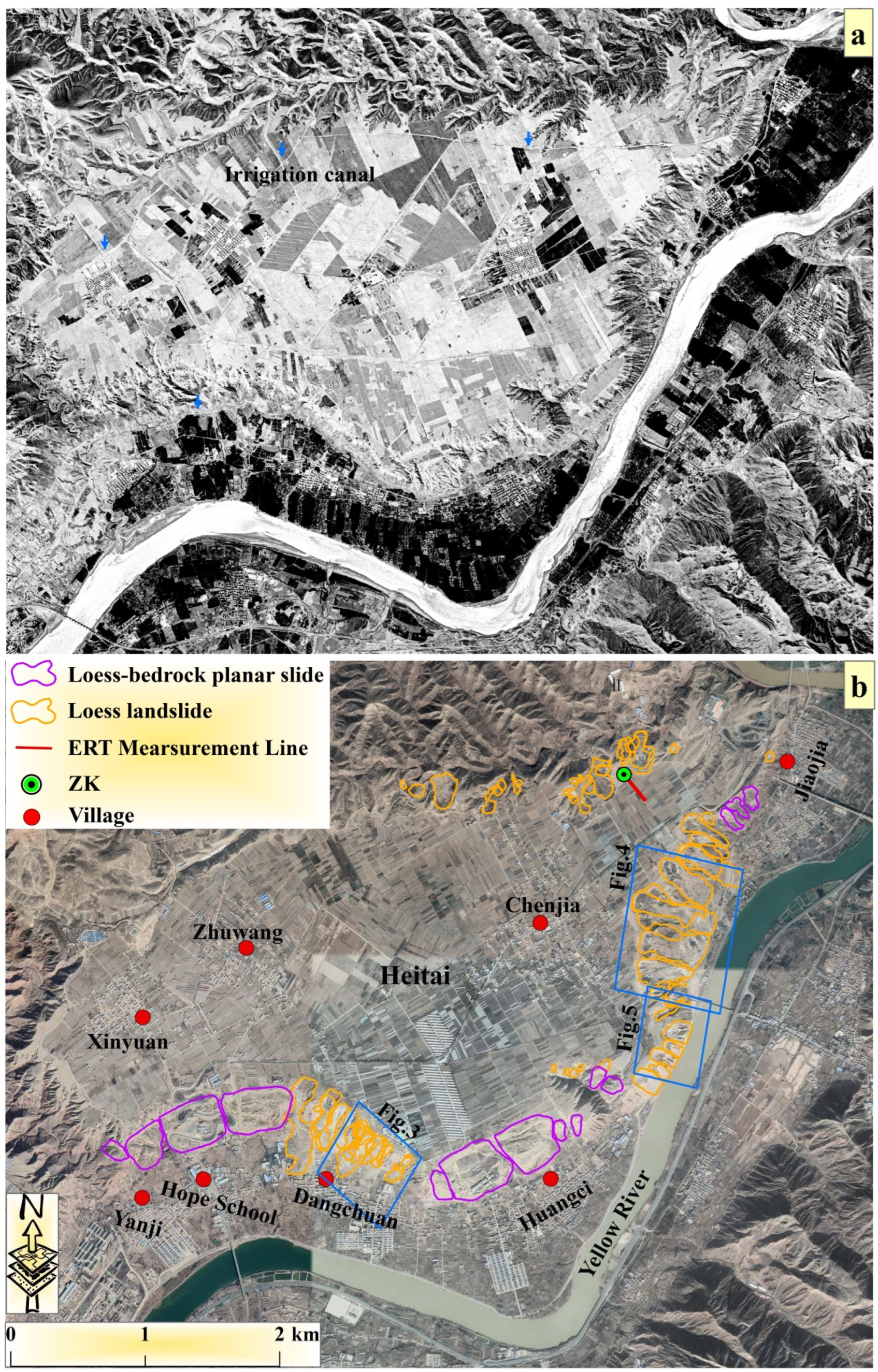
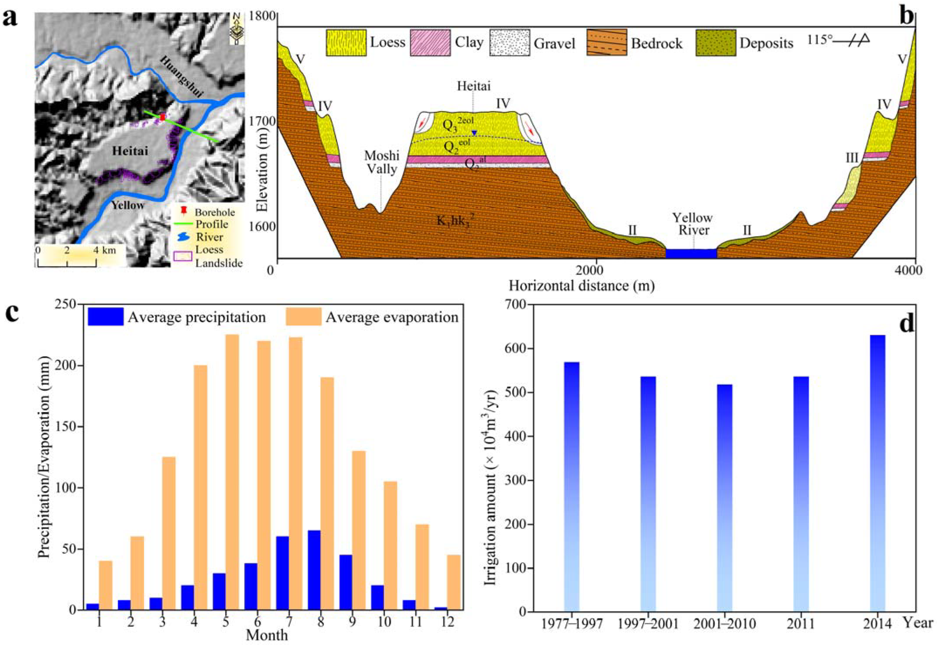
2.1. Study Area

The Heitai terrace is located in Yanguoxia Town, Yongjing County, Gansu Province. It lies to the west of the Loess Plateau, with the geographical coordinates of 36°6′27″N, 103°18′59″E. The Heitai area comprises hills and gullies, typical of the western part of the Loess Plateau, while the dominant landform is a loess platform that comprises terrace IV of the Yellow River, covering an area of approximately 12 km2. The platform is high in the northwest and low in the southeast, with relatively small topographical undulations of approximately 3 m.
The stratigraphy of Heitai terrace from bottom to top (Figure 2b) is as follows: (i) basement rocks, consisting of sequences of minor sandstone and thick mudstone of the Cretaceous Hekou Group; (ii) pebble, gravel, and clay layers of Middle Pleistocene age; and (iii) loess cover, approximately 25–50 m thick, comprising the Middle Pleistocene Lishi loess and Upper Pleistocene Malan loess. According to incomplete statistics, approximately >90% of the loess-related landslides on Heitai terrace have occurred in the loess cover layer [38].
The Heitai region belongs to the temperate semi-arid climate zone, having an average annual precipitation and evaporation of approximately 310 mm and 1633 mm, respectively (Figure 2b). Heitai terrace is deeply cut by several gullies, including Hulanggou and Moshigou, and differential vertical movement of the Earth’s crust has resulted in the terrace platform now being approximately 100–130 m above the modern riverbed. Therefore, Heitai terrace receives virtually no lateral water recharge from the adjacent river. Under natural conditions, atmospheric precipitation is the only source of groundwater recharge, but this is insufficient to enable a rise in groundwater level; hence, under natural conditions, Heitai is a dry terrace platform. In the early 1960s, an irrigation project began to be carried out on Heitai terrace to ensure the agricultural productivity of migrants. The total annual irrigation volume increased from ~5,700,000 m3 in 1977–1997 to ~6,300,000 m3 in 2014, an approximate 11% increase (Figure 2d). By 2012, the groundwater level had risen by at least 20 m compared with that in the 1960s, and the groundwater continues to rise at a rate of 0.18 m/year [16].

2.2. Numerical Analyses

A rise in groundwater level and the attenuation of soil strength can both influence the landslide failure process during the evolution of landslides on Heitai terrace. To further analyze their relative contributions to the landslide failure process, we adopted the following three scenarios: (i) rising of groundwater level was used as an independent variable, and attenuation of soil strength was used as an irrelevant variable; (ii) attenuation of soil strength was used as an independent variable, and rising of groundwater level was used as an irrelevant variable; (iii) both rising groundwater level and attenuation of soil strength were used as independent variables. For the soil strength parameters in the model, the details of their specific attenuation process are as follows: in the unsaturated loess layer, 10% and 5% of the initial cohesion and internal friction angle [37], respectively, were used as strength parameters after the first attenuation; then, the strength parameters of the previous attenuation were sequentially used as the initial strength parameters and attenuated according to the above ratio; in the saturated loess layer, the attenuation ratios of cohesion and internal friction angle were set to 15% and 10%, respectively. In addition, based on the calculation of the relationship between peak and residual strength parameters in seven groups of different water contents in the Loess region [39], the model used 85% of the peak cohesion (Cp) as the residual cohesion (Cr) and 90% of the peak internal friction angle (φp) as the residual internal friction angle (φr), as shown in Table 1. The Poisson’s ratios entered into the model were 0.35 and 0.3 for unsaturated and saturated soils, respectively, and the natural and saturated bulk weights were 16.7 and 17.7 kN/m3, respectively. The model used for the numerical analysis was obtained from a DEM based on the GIS platform, and the prototype is derived from the loess slope (as shown in the profile) in Figure 3.
Although the model is not able to provide the change laws of groundwater level rise and soil strength discontinuous attenuation during the actual irrigation period, nor their one-to-one corresponding relationship, it still provides a positive reference for the analysis of the real-world landslide failure process.

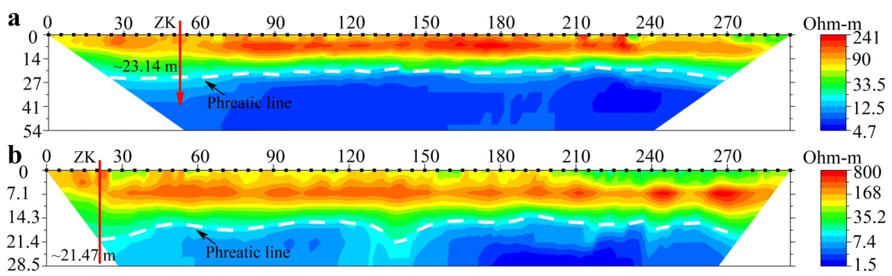
2.3. Electrical Resistivity Tomography (ERT)

The change in the apparent resistivity of soil is closely related to its water content. The calibration of the apparent resistivity using the measured water content of the soil, combined with the apparent resistivity obtained using high-density ERT, can indirectly reflect the distribution of the water content of a soil profile. Thus, ERT has been widely used for groundwater detection [40,41]. We analyzed the effects of irrigation projects on groundwater changes within Heitai terrace using two ERT measurement lines (each line has 60 electrodes and a spacing of 5 m) placed in the typical areas of Heitai terrace in 2019 and 2021. Two-dimensional Wenner data of apparent resistivity were obtained using AGI EarthImager 2D 2.4.0 inversion software. An apparent resistivity value of approximately 15–21.65 Ω/m was inferred as the phreatic surface [23,38,40] and this was verified by borehole groundwater-level results (Figure 1).

2.4. SBAS–InSAR

The time-series interferometric synthetic aperture radar (InSAR) method is an extension of differential radar interferometry. It is utilized to analyze the spatiotemporal evolution of earth surface displacements by estimating large-area deformation by incorporating information from multiple SAR interferograms [42]. Permanent scatterers (PS–InSAR) and small baseline subsets (SBAS–InSAR) are the two most prevalent time series analysis methods [43,44,45]. The PS–InSAR method employs persistent scatterers to detect surface deformation, which is primarily applicable for landslides and land subsidence monitoring in urban areas, but not in densely vegetated regions. Moreover, this method necessitates the selection of a super-master image from the acquired data (>15 images), and the registration of the remaining images with it to generate an interferogram (even if the data used have a large temporal and spatial baseline), which makes the interferogram susceptible to baseline incoherence. Only targets with adequately high coherence values will be detected, while those with low coherence values will be masked. Therefore, this technique reduces the pixel density of an image [46,47,48]. SBAS–InSAR generates interferograms from data pairings with short time and orbital separation (spatial baselines) to limit the spatial decorrelation phenomenon. This method increases the temporal sampling rate of the data while preserving the system’s capacity to produce a spatially dense deformation map [48].
The Heitai terrace is almost entirely covered by agricultural crops, which may result in a limited number of permanent scatterers. The SBAS–InSAR method primarily extracts distributed scatterers and can provide more monitoring points [49,50,51]. Therefore, the SBAS–InSAR method was chosen to analyze recent and predict future landslide activity on the Heitai terrace. We obtained 209 scene Sentinel-1A images covering Heitai terrace, spanning the period 14 October 2014 to 17 February 2023. In addition, we obtained 117 scene Sentinel-1A images covering the Sanmaxiaotai Yellow River terrace (located approximately 6 km from Heitai terrace), on which there are no irrigation projects; these images spanned the period 24 February 2017 to 16 April 2021. The above data are from ascending orbits with a repeat period of 12 to 24 days and a ground resolution of 30 m provided by the European Space Agency (ESA) (https://search.asf.alaska.edu/ accessed on 12 April 2023). The STRM DEM (30 m resolution) from the United States Geological Survey is used for terrain phase removal and geocoding. Using ESA’s (https://scihub.copernicus.eu/) orbital data, the flat-earth phase is removed.
Using a temporal baseline of 24 days and a spatial baseline of 150 days, interference pairs were generated for interferogram processing. This is because the terrain, the flat earth, the noise, and the atmospheric phases were included in the original interferogram. Therefore, we use the minimum cost flow method to solve the original interference phase from the wrapping phase with a period of 2π [52], using STRM DEM to remove the slope terrain phase and an adaptive filter function to smooth the interfering phase, minimize phase noise, and improve monitoring accuracy [53]. Then we examined the interferograms, deleted those with low coherence, poor interference effect, and bad unwrapping (phase jump), and used the remaining data to reverse the surface deformation rate [51]. To remove the residual orbital phase, ground control points are chosen, and a linear model is used to calculate the initial surface deformation rate. Since the atmospheric signal phase component exhibits a high spatial correlation but a significantly low temporal correlation, we employ low-pass filtering at the spatial level and high-pass filtering at the temporal level to remove the influence of the atmospheric phase component [47]. We then calculate the final surface deformation using the least squares and singular value decomposition methods [48]. Lastly, geocoding is used to transform the deformation data from the SAR coordinate system to the geographic coordinate system. We used the SARscape 5.2.1 plug-in of the ENVI 5.3 software and followed the relevant steps to obtain mm-scale ground time series of displacement data for the two regions.

2.5. Field Investigation

The standard deviation and mean of the deformation data are used to determine the relative stability threshold. The standard deviation reflects the extent of change and the range of distribution for the majority of the data, and it serves as an essential reference for determining the stability threshold [54]. In previous studies, the SBAS–InSAR technique was used to identify potential landslides on the Heitai [51,55,56,57], and the reliability of the InSAR results was confirmed by the GNSS results [56,57]. Therefore, the comparability with previous InSAR results can validate the accuracy of the InSAR results presented in this study. Meanwhile, field investigation, which can directly observe the surface activity characteristics, is a more reliable method for validating the accuracy and reliability of the InSAR results [45,51,57,58]. In order to further analyze the landslip activity of the Heitai, we also selected validation areas to further verify the accuracy of the InSAR results based on the slope threat targets and the variations in deformation rates. Here, the observed deformation signs were used as a direct basis for the surface activity, which included cracks, sinkholes, falls, landslides, and vegetation. Additionally, the distribution and morphology parameters of the cracks, including the width, distance from the platform edge, and vertical offset, as well as the dimensions of the sinkholes and local failures, and the cumulative deformation of the root system of the vegetation, were further observed. In contrast, there was no sign of the previously mentioned deformations in the relatively stable region.

3. Results

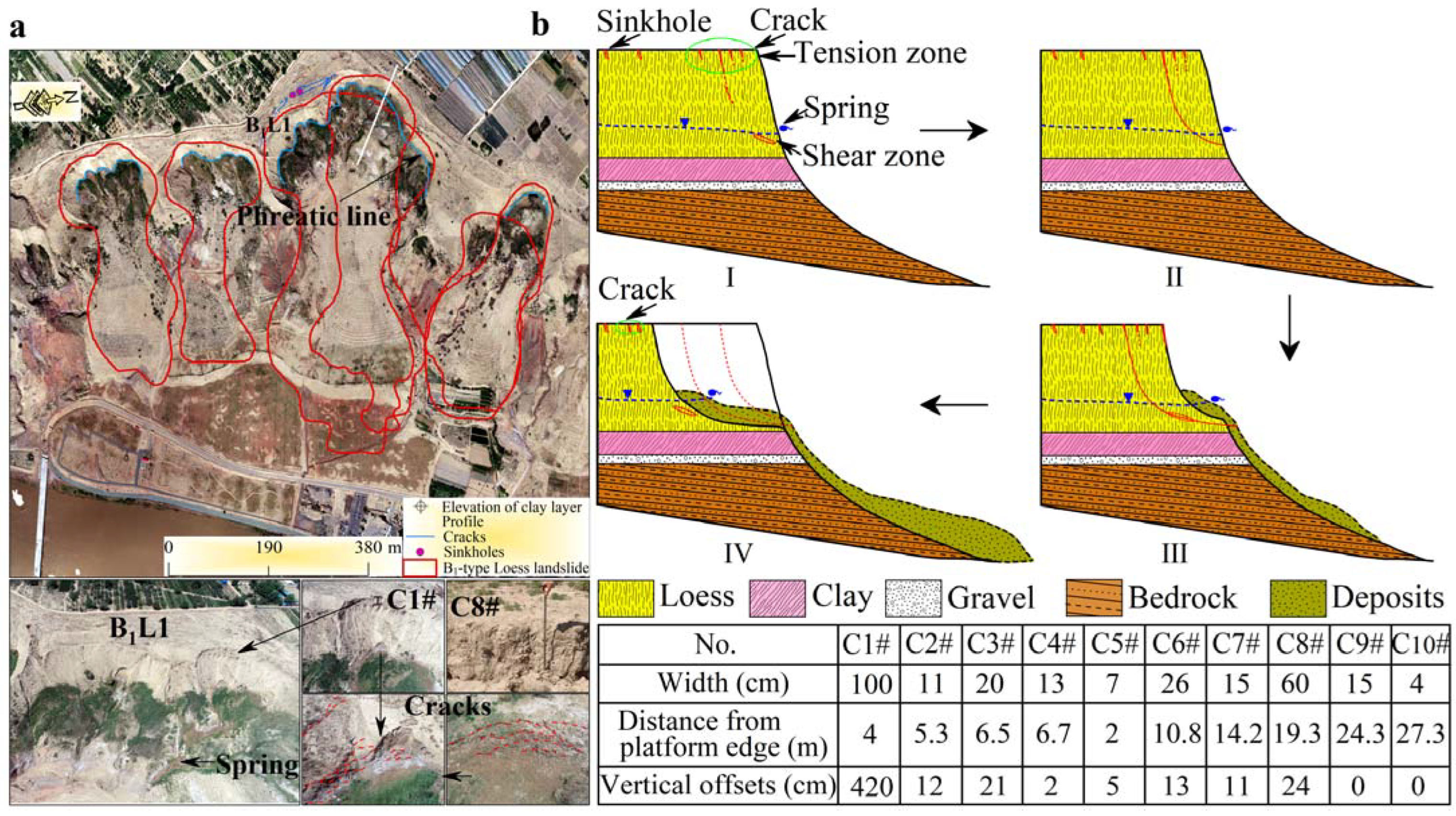
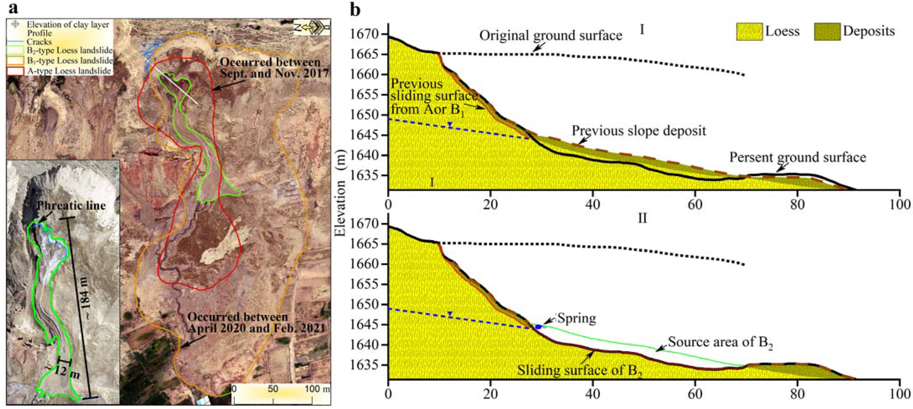
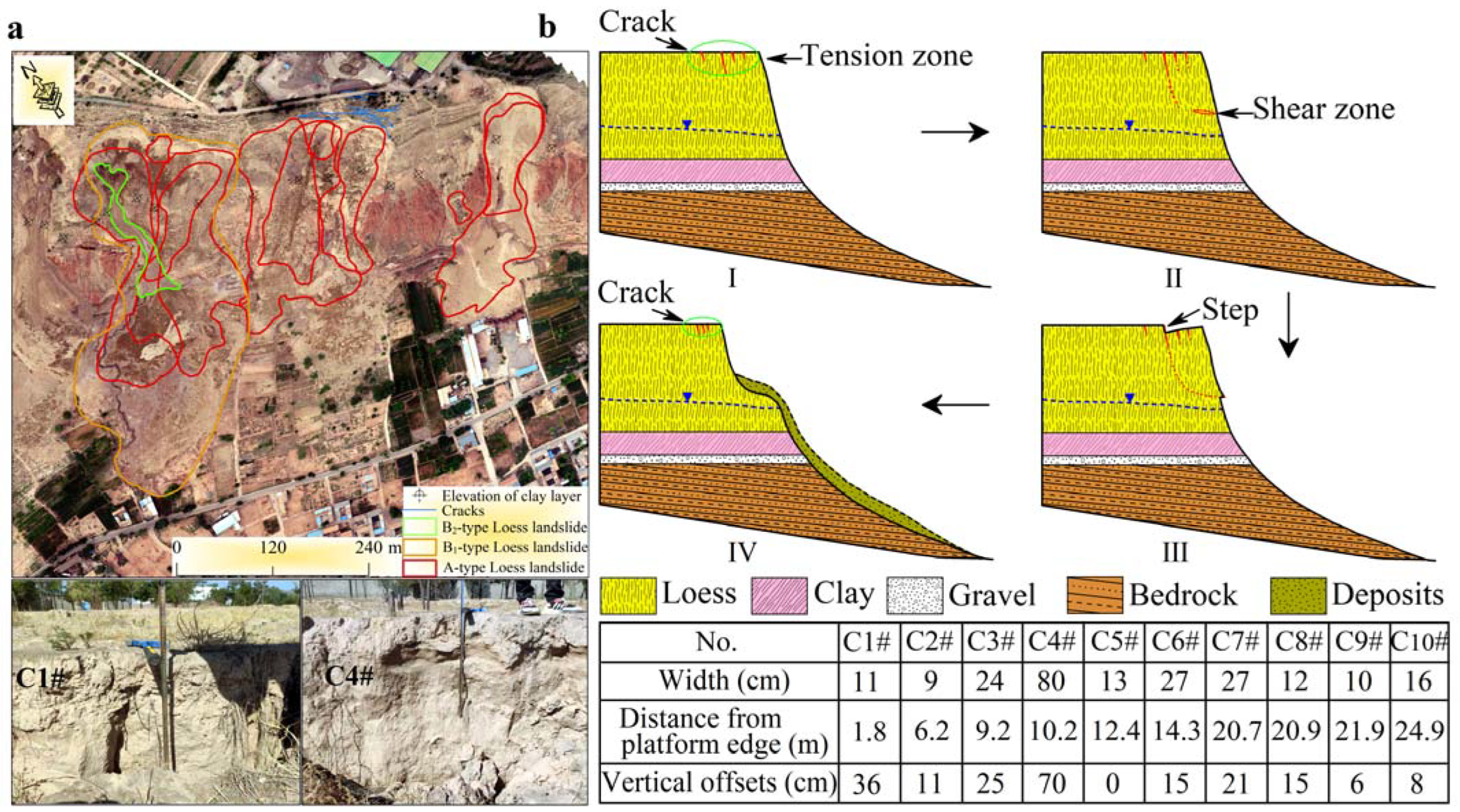
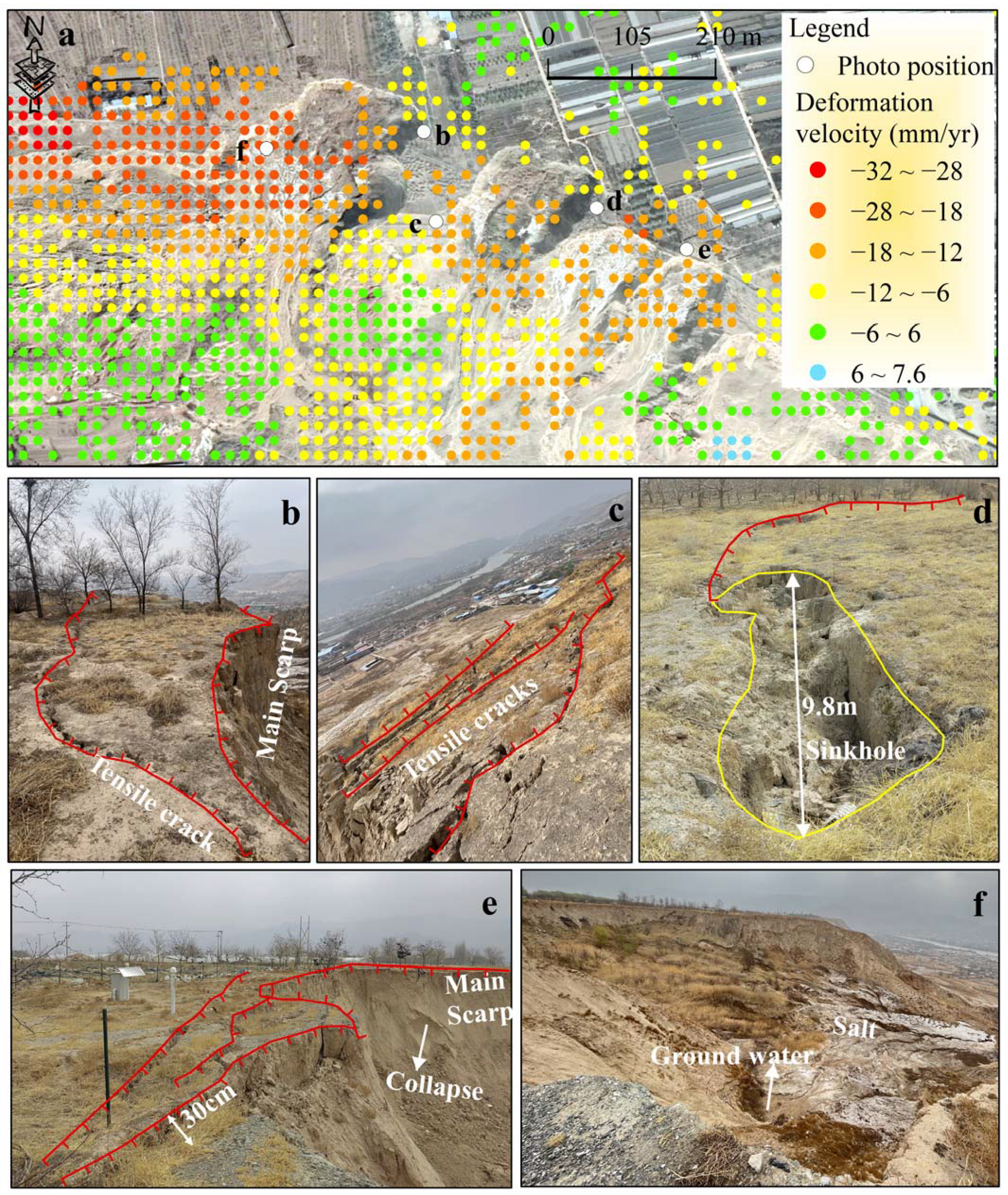
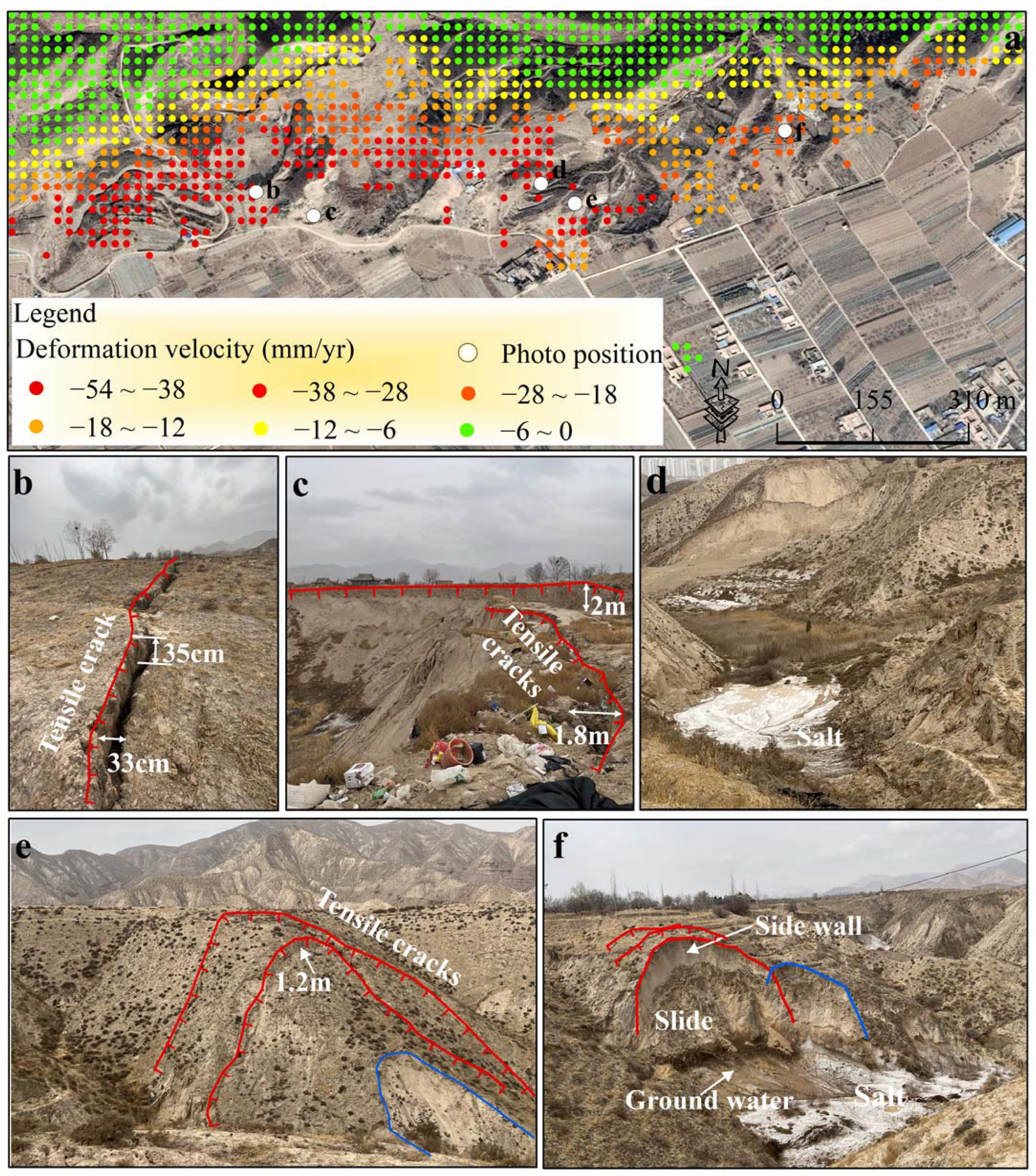
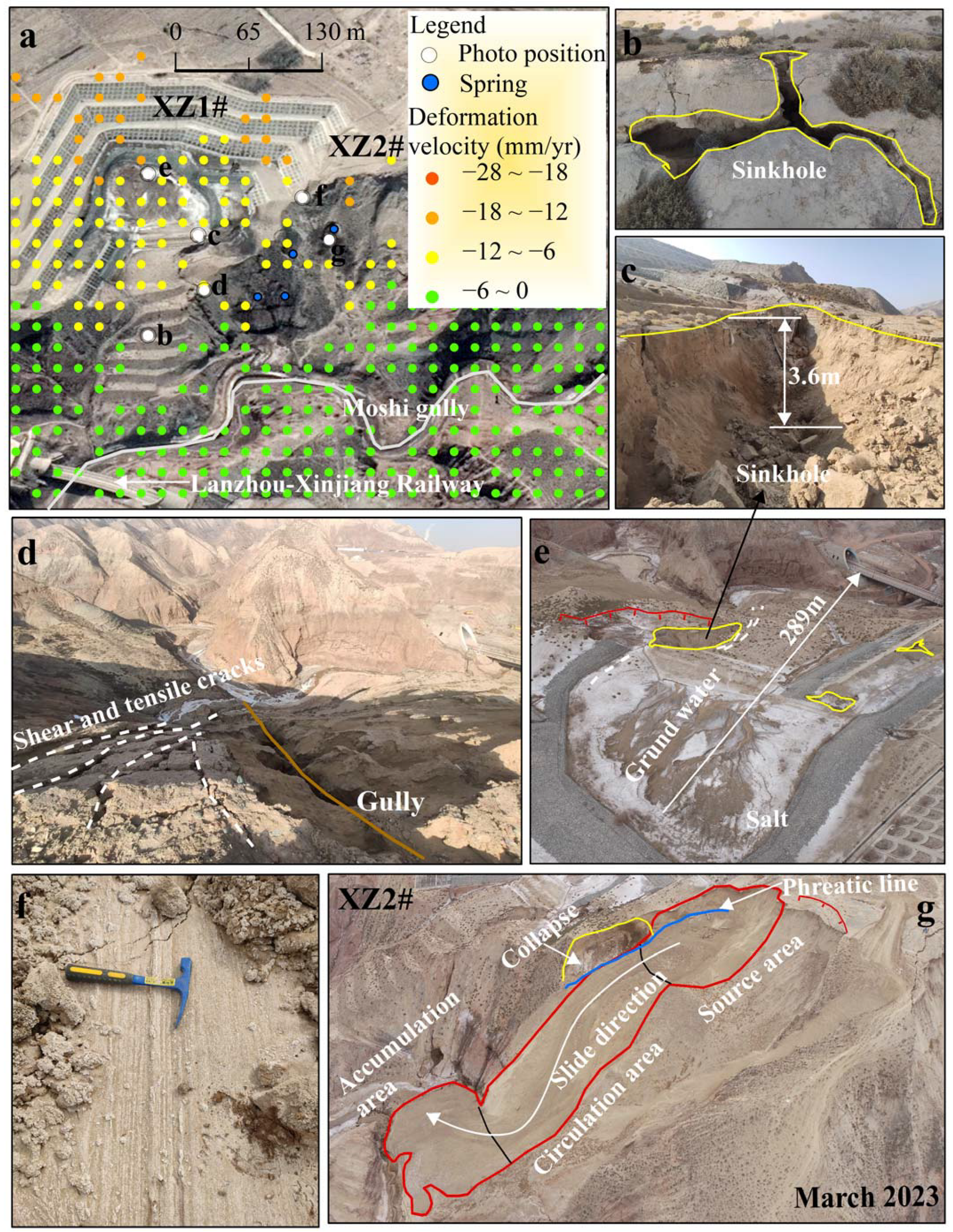
3.1. Type B1 Loess Landslides—Groundwater-Related

The results of our field investigation showed that cracks in the crown prior to the occurrence of type B1 landslides tended to occur in groups. As shown in Figure 3a, the crack widths ranged from approximately 4–100 cm, their vertical offsets ranged from approximately 0–420 cm, and their distances from the platform edge ranged from approximately 2–27.3 m. In addition, phreatic lines were observed on the landslides, and part of each failure surface was within the saturation zone. It is worth noting that local small-scale failure occurred near the phreatic line of some landslides, with a high probability of extension into the surrounding area; multi-stage cracks had developed in the sidewalls and crowns of the failure areas, and springs continued to discharge outwards (Figure 3a). Previous studies have confirmed that the soil strength in the spring discharge path is markedly reduced owing to changes in soil properties, and soil deformation is related to the total amount of soluble material lost from the soil interior via spring water [35,37]. In addition, both land use and spring discharge have significant impacts on groundwater [21,59,60], causing an increase in hydraulic gradient and positive pore water pressure owing to the differential rise in groundwater caused by the crop planting structure, which may also contribute to the failure at this site.
On the basis of field observations of the deformation signs of the B1 landslide during its evolution, we believe that the failure mode of type B1 landslides is related to extension dominated by the yield in shear zones in the lower part of the slope, and extension dominated by the yield in tension zones in the crown, and a schematic sketch of the failure mode is given (Figure 3b). The general extensional manifestation of the yield in shear zones in the lower part of the slope was observed in the field in the form of local deformation or failure and extension to adjacent areas, whereas the yield in tension zones in the crown was manifested in the development and evolution of cracks in the crown (Figure 3b(I)). Under the status quo, the formation and development of cracks in the crown are associated with the unloading of soil at the platform edge caused by previous landslide events and mechanical erosion by water; the further development of cracks is associated with the discontinuous attenuation of soil strength during irrigation. In addition, the deformation or failure of the lower part of the slope, especially the substantial weakening of the soil strength in the lower saturated zone compared with other locations within the shear zone, may contribute to the development of cracks in the crown. In summary, during the landslide evolution process, the potential shear zone will continue to decrease with continued expansion of the yield in the tension zone in the crown and shear zone in the lower part of the slope (Figure 3b(II)). Meanwhile, early attenuation of soil strength in the shear zone occurs. When the potential shear zone area is reduced to a certain critical state, it will be directly sheared owing to an increased concentration of shear stress, causing sudden entire failure (Figure 3b(III)) and repeated regressive failure over a period of time (Figure 3b(IV)). It should be noted that landslide failure does not necessarily require complete penetration of the failure or yield surface.
Previous studies have also suggested that liquefaction-type landslides (otherwise known as flow slides, which may belong to the type B1 landslide category) are related to loess liquefaction under undrained conditions caused by excess pore-water pressure owing to shear shrinkage, or the rise of groundwater due to topographic changes caused by localized failure [61,62,63]. However, it has also been shown that this type of landslide may not easily meet the conditions for full liquefaction; because these landslides occur at depth, the soil brittleness index (the brittleness index is defined by Bishop [64] to quantity the degree of the strength reduction of a strain-softened material decreases in the under undrained conditions, and is closely related to the liquefaction capacity of materials [65,66,67] is lower at higher confining pressures [68]. Recent studies have concluded that although the increase in loess densification induced by prolonged irrigation in the Heitai leads to a change in the pore ratio, the brittleness index may gradually increase above the critical pore ratio, and therefore loess flow slides may still occur [69]. Here, we believe that previous research results are not inconsistent with the failure mode proposed in this study, because regardless of the way excess pore–water pressure or an increase in pore-water pressure is promoted, the main result is to cause a marked attenuation of the soil peak and steady-state strengths in the saturated zone, which in turn contributes to meeting the triggering conditions for the failure of the entire slope. Field observations of type B1 landslides and analysis of their failure modes indicate that these landslides have caused large-scale disasters.
Figure 3. Type B1 landslides (location shown in Figure 2). (a) Field investigation of a typical B1L1 landslide, including crown crack groups, sliding areas, sliding surfaces, spring lines, springs, salts, and small deformation failures in the lower part of the slope. (b) Type B1 landslide failure mode. Cn# stands for crack, n# for the No. of cracks. I to IV represent the evolution of type B1 landslides on terraces.
Remotesensing 15 05012 g003

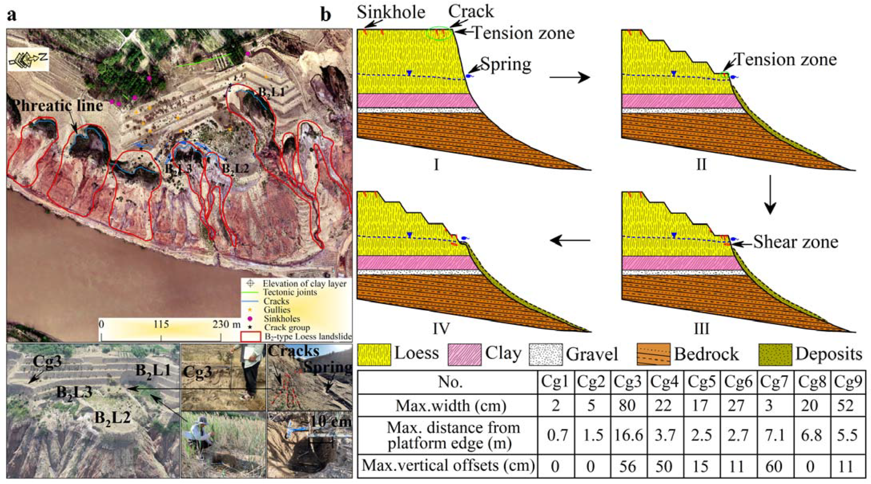
3.2. Type B2 Loess Landslides—Groundwater-Related

The results of our field investigation indicated that type B2 landslides are currently concentrated in the area of slope-cutting engineering, with far fewer cracks developing at the top of these slopes compared with nearby areas lacking slope-cutting engineering (Figure 4a). However, in the crown of the step of the lower part of the slope-cutting engineering area, cracks occurred in groups, with maximum widths of approximately 2–80 cm, maximum vertical offsets of approximately 0–60 cm, and maximum distances from the platform edge of approximately 0.7–16.6 m. Although all of these cracks were smaller than those related to B1 landslides, they often represent the location where B2 landslides occur. In addition, phreatic lines were observed on the landslides, and the vast majority of failure surfaces were within the saturated zone. It is worth noting that three pieces of evidence from the field site suggest that the current B2 landslide continues to deform. First, the lower bush has inclined in the direction of the previous slide and there is already 10 cm of cumulative deformation at the roots; second, multi-stage cracks have developed in the sidewalls and crown of the failure zone; and third, the spring continues to drain outwards.
We believe that the type B2 landslides differ from type B1 landslides in their mode of failure, based on field observations of the deformation signs of the B2 landslide during its evolution (Figure 4b(I)). Although the extension of the crown dominated by the yield in the tension zone is similar to that of type B1 landslides, the upper loads of type B2 landslides are lessened by the slope-cutting engineering; additionally, the failure surfaces are mainly concentrated in the saturated zone, and the type B2 failure mode may be dominated by total failure caused by shear liquefaction of the lower part of the slope (Figure 4b(II),(III)). In addition, owing to the low potential energy, the failed material tends to move in the form of mud over short distances (Figure 4a,b(IV) and Figure 5a). The reasons why type B2 landslides can occur on Heitai terrace are as follows: (i) slope-cutting engineering lessens the loading of landslides, resulting in low confining pressures during the lower soil shear process; (ii) the reduction in effective stress between particles and attenuation of soil structural strength, which results from the increases in hydraulic gradient and pore water pressure owing to the differential rise in groundwater caused by the crop planting structure, as well as the loss of soluble material via springs over many years.

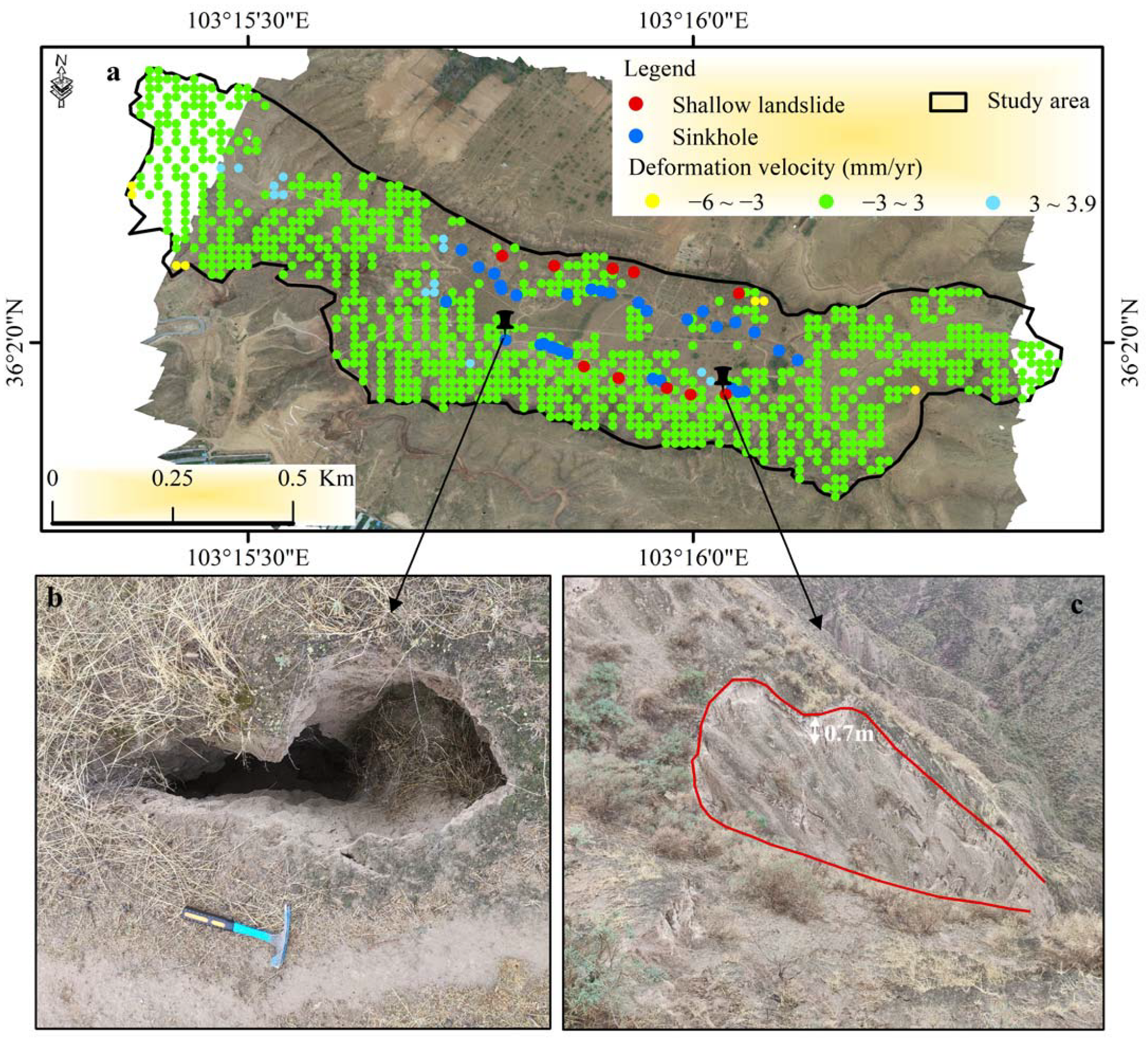
3.3. Type A Loess Landslides: Not Associated with Groundwater

The results of our field investigations indicated that cracks in the crown prior to the occurrence of type A landslides usually also tended to occur in groups. As shown in Figure 6a, their widths ranged from approximately 9–80 cm, with vertical offsets of approximately 0–70 cm, at distances from the platform edge of approximately 1.8–24.9 m. In addition, unlike the type B landslides, no phreatic lines were observed on the type A landslides, and the failure surfaces of the landslides were within the unsaturated zone. It is noteworthy that in the area where previous type A landslides were concentrated, phreatic lines can now be observed in the lower part of the slide area; this may be related to a localized rise in groundwater level at the platform edge owing to the type A landslides blocking the previous spring discharge; alternatively, the landslide failure mode may have transformed and type B landslides began to develop (Figure 5a).
Based on field observations of the deformation indicators of the A landslide during its evolution, we believe that the failure mode of type A landslides is associated with extension dominated by yield in the tension zone in the crown (Figure 6b), which, as described in Section 3.1, is associated with mechanical erosion by water and discontinuous degradation of soil strength during irrigation. However, the difference compared with type B1 landslides is that there may be little contribution to crack extension from the deformation of the lower part of the slope (Figure 6b(I)). Because the shear zone in type A landslides is always located in the unsaturated zone, there is little attenuation of the strength of the lower soil compared with other locations on the shear surface. This is because there may not be a marked decrease in soil suction, or marked change in soil properties, owing to head differences in the lower soil. In summary, during the evolution of type A landslides, the shear zone area decreases with the continued extension of the yield in the tension zone of the crown (Figure 6b(II)). Meanwhile, early attenuation of soil strength in the shear zone occurs. Because the total shear stress of the sliding mass remains approximately constant, when the yield in the tension zone increases to a certain critical state, the lower potential shear zone may be directly sheared owing to the increased concentration of shear stress, causing an entire failure (Figure 6b(III),(IV)). Previous studies have suggested that this type of landslide may also result from shear failure in the lower part of the slope first associated with rainwater entering the interior of the soil mass through fissures and forming a weak layer in the upper part of the clay layer; then, the upper cracks may extend to greater depth owing to the movement of the lower part of the slope, which in turn causes failure [38]. We suggest that this failure mode may have existed during the early stages of Heitai terrace irrigation.
Although type A landslides have relatively high shear outlets, the potential energy is relatively low owing to the smaller volume [20]. Therefore, this type of landslide generally receives little attention owing to it causing relatively small-scale disasters. However, the redistribution of stress within the soil mass after type A landslide occurrence, especially during the shear process of the lower part of the slope under low confining pressure, may satisfy the liquefaction condition [68]. In addition, previously, type A and type B1 landslides can cause local rises in groundwater level, as the concave topography they create can facilitate the convergence of groundwater paths [61,62,70] or the blockage of spring discharge points by landslide deposits [59,71], which also facilitates liquefaction under the no drainage conditions. In conclusion, their occurrence may contribute to a transformation in landslide failure modes; for example, the triggering conditions for type B2 landslides may be more easily created in such locations. At the location shown in Figure 5, according to the results of optical image interpretation, type A landslides first occurred between September and November 2017, type B1 landslides occurred between April 2020 and February 2021, and a type B2 landslide occurred recently. We infer that the type A and B1 landslides contributed to the occurrence of the type B2 landslide. Owing to the lack of data on changes in spring behavior and groundwater level at this location before and after the occurrence of the type A landslides, we cannot provide an indication of the contribution of the type A landslides to the occurrence of the type B1 landslides.

3.4. Numerical Analyses

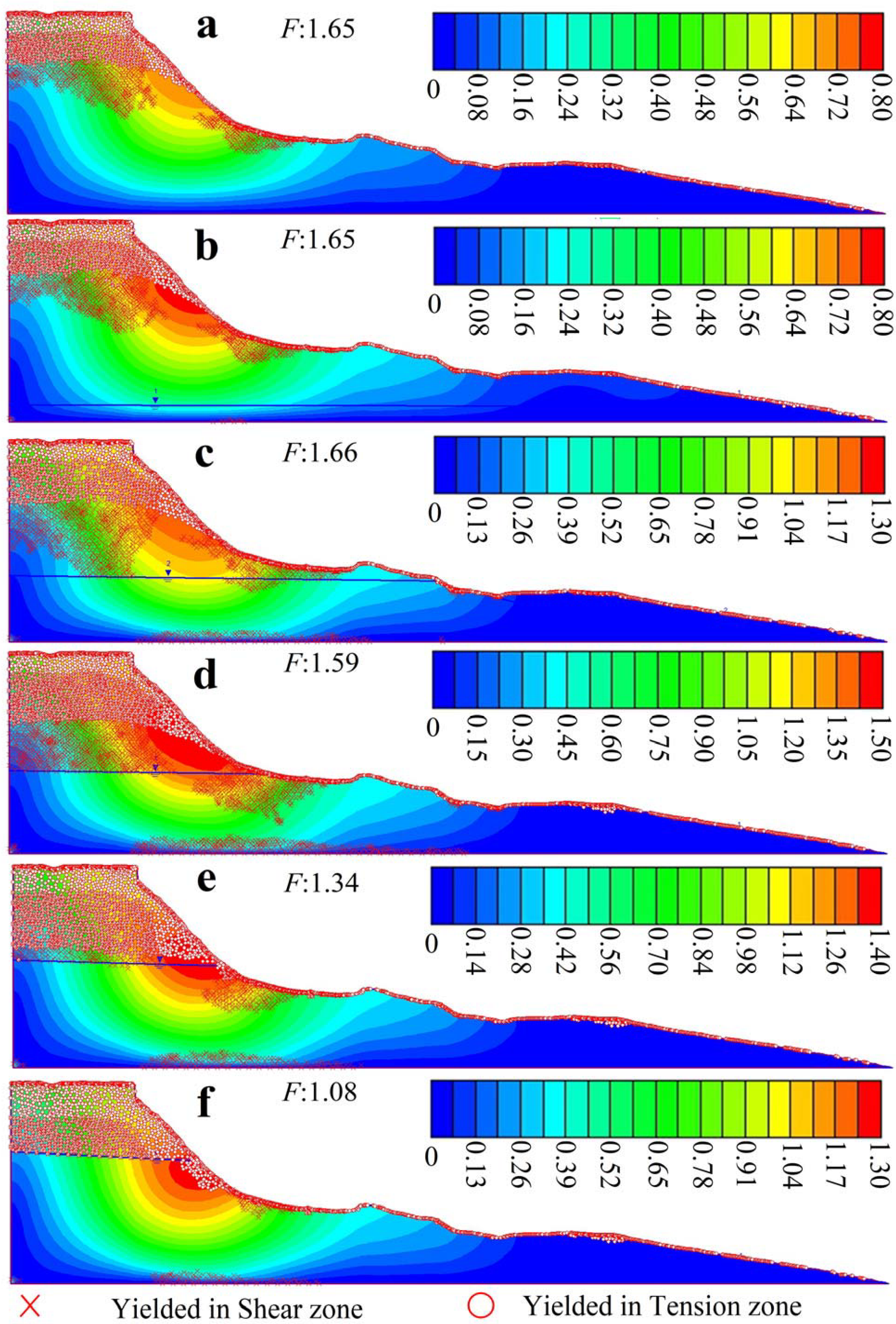
3.4.1. Variables: Groundwater Rise

We analyzed the possible change characteristics of the yield zone during the rise in groundwater level. In the initial stage of the rising groundwater level (Figure 7a,b), the yield in the tension and shear zones remained almost unchanged; then, as the groundwater level rose, the yield in the tension zone of the crown extended to deeper layers, and the yield in the shear zone of the lower slope extended towards the upper slope (Figure 7c) and deeper layers (Figure 7d); as the groundwater level continued to rise, the yield in the tension zone of the crown further extended to the deeper layer, while a reduction in the yield in the shear zones was observed, which may be related to locations where the stress conditions for yielding were exceeded, or conditions for failure were met, owing to a continued increase in pore water pressure. The marked extension of the yield in the tension zone to the lower part of the slope may also indicate that the part of the lower part of the location has reached a state of failure (Figure 7e). As the groundwater level rose still further, the stress conditions for failure were met over a larger area of the lower slope, and the yield in the tension zones of the crown and slope surface extended further into deeper layers and lower parts of the slope, respectively, suggesting that the slope was about to enter a state of total failure (Figure 7f).
In summary, on the basis of this numerical analysis, we have shown that there is a more substantial decrease in slope stability in the later stages of rising groundwater (Figure 7c,d) compared to the early stages of groundwater rise (Figure 7a–c). However, if the frequent landslides on Heitai terrace are attributed solely to rising groundwater levels, it is difficult to explain the current frequency and inter-annual changes in landslide activity at the present groundwater level, especially the active periods of 2007 and 2008 [38].

3.4.2. Variables: Soil Strength Attenuation

The characteristics of the possible changes in the yield zones during the attenuation of soil strength are shown in Figure 8. With increasing soil strength attenuation, the yield in the tension zones of the crown and slope surface expanded to deeper layers and lower parts of the slope, respectively, and the yield in the shear zone of the lower part of the slope expanded towards the upper and deeper parts of the slope.
In summary, according to this numerical analysis, with discontinuous attenuation of the initial soil strength during the irrigation period, there will not only be a substantial decrease in the stability of the slope but also a contribution to the failure process of the slope.

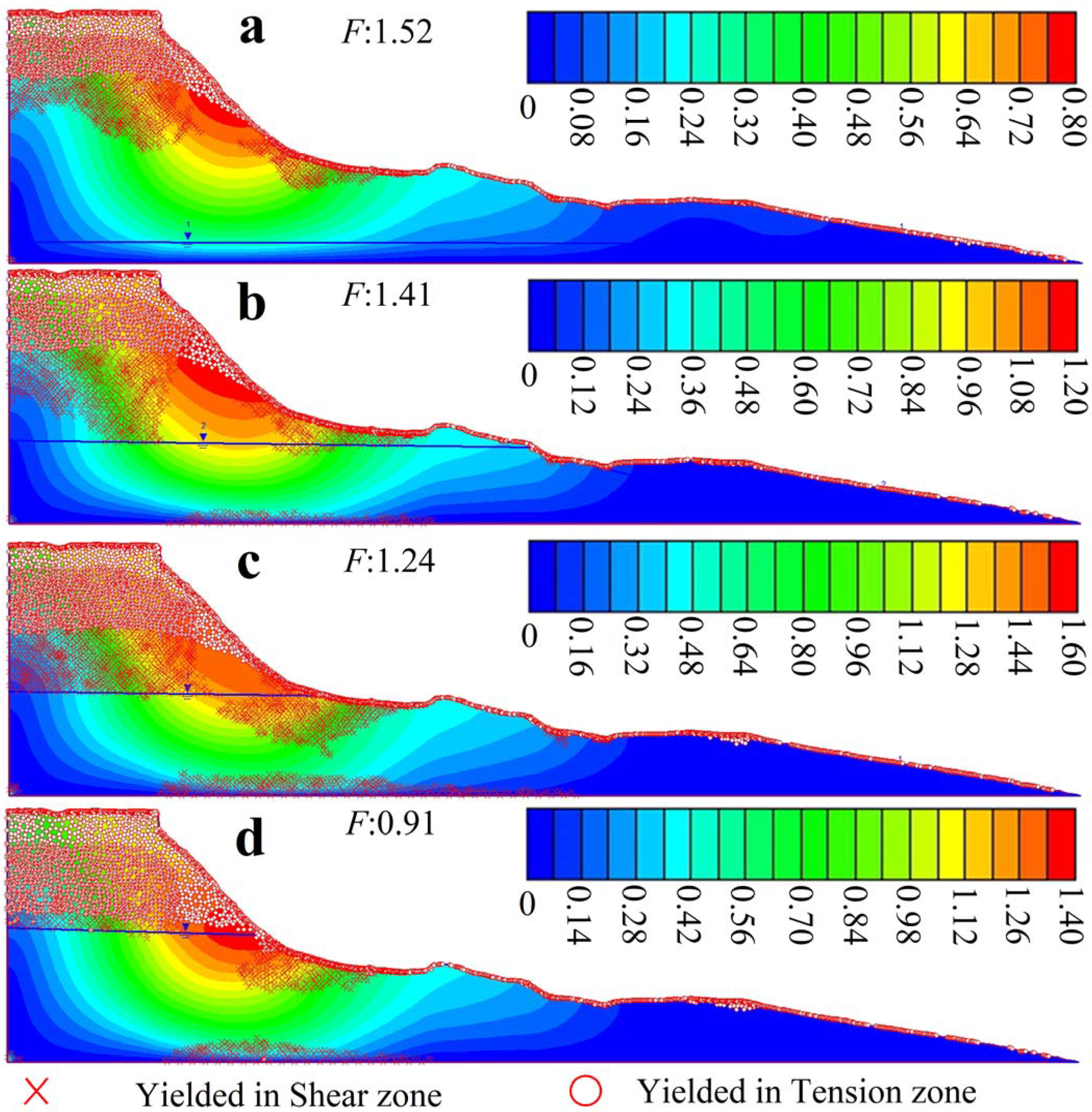
3.4.3. Variables: Groundwater Rise and Soil Strength Attenuation

Compared with Figure 7 and Figure 8, Figure 9 shows that a consideration of both the rising groundwater and soil strength attenuation resulted in the slope more easily meeting the conditions for failure. With an initial rise in groundwater level and attenuation of soil strength, the yield in the tension zone of the crown extended to deeper layers, and the yield in the shear zone of the lower part of the slope extended towards the upper slope and deeper layers (Figure 9a–c). With a further rise in groundwater level and attenuation of soil strength, the yield in the tension zone of the crown expanded markedly into deeper layers, and a reduction in the yield in the shear zone of the lower slope was observed, which may again be related to locations where the stress conditions for yielding were exceeded, or conditions for failure were met. Combined with the substantial extension of the yield in the tension zones to the lower part of the slope, the slope may have entered a state of total failure (Figure 9d).
In summary, these numerical analyses of the change in yield zones during landslide evolution emphasize that it is important to consider the contribution of the discontinuous attenuation of soil strength during irrigation to the failure modes of landslides within the loess layer of Heitai terrace.

4. Discussion

4.1. Potential for Future Landslides on the Heitai Terrace

According to the deformation rate distribution map of the platform (based on the standard deviation and mean value of the coherent point target: and based on field investigation, the relative stability threshold of the study area is set in the range of −6 to 6 mm/year), the maximum deformation rate of Heitai terrace is concentrated in the range of −67 to −28 mm/year and distributed at the platform edge (Figure 10a). This is generally consistent with previous monitoring of activity in the region [52,55] (Figure 10). Moreover, we select the group of Dangchuan landslides in the residential gathering area (Figure 11), the group of Moushi Gully landslides with the highest deformation rate (Figure 12), and the Xinzhuang (XZ) landslide that threatens the Lanzhou-Xinjiang Railway (Figure 13) to further validate the accuracy of the InSAR result, and then to analyze the landslide activity of the Heitai.
The group of Dangchuan landslides. In the group of Dangchuan landslides, one slide with a sliding distance of 782 m occurred on 29 April 2015, resulting in the destruction of houses, factories, cultivated land, and roadways. The most recent activity occurred on 27 January 2021. Currently, the Dangchuan landslide group persists with strong activity, with annual deformation rates ranging from −32 mm to 7.6 mm. The deformation of the previous sliding source area exceeded the InSAR monitoring range, resulting in a decorrelation phenomenon (missing monitoring points) (Figure 11a). Field observations revealed that the arc-shaped tension cracks developed at the landslide crown were the most significant deformation feature of the group of Dangchuan landslides and that the morphological parameters of the cracks near the platform margin were the most complex, exhibiting the greatest crack distribution density, width, length, and vertical offset (Figure 11b,c,e). Distant from the platform’s edge, the sinkholes are observed to be evolving into cracks (Figure 11d). Moreover, spring activity persists at the foot of the slope, and our previous research confirmed that the loss of soluble material via the spring is positively correlated with slope deformation (Figure 11f) [35].
The group of Moshi Gully landslides. This is the location of the most severe slope deformation in the region, with annual surface deformation rates ranging from −54 mm to 0 mm, and the strong surface deformation is the primary cause for the lack of monitoring data in localized areas along the slope’s back edge (Figure 12a). Currently, the tension cracks that have developed at the crown of the landslide have a width of approximately 0.33 to 1.8 m and a vertical offset of approximately 0.35 to 2 m (Figure 12b,c), and some of the cracks at the crown of the slope and on both sides of the slope have been gradually penetrated, resulting in a rim chair shape. Consequently, both recent and impending landslides can be clearly observed here (Figure 12d–f).
The Xinzhuang landslides. Although the XZ1# landslide has undergone engineering management, the annual deformation rate remains between −28 mm and 0 mm, posing a potential threat to the Lanzhou-Xinjiang Railway’s secure operation (Figure 13a). The formation of sinkholes and deep-cut gullies on the slope is related to abundant groundwater at this location (Figure 13b,d,e), which may further contribute to the development and evolution of longitudinal shear and tension cracks on the slope (Figure 13c,d). Notably, the termination date for InSAR surface data was 17 February 2023, and a new type B1 landslide (with the sliding surface partially below the groundwater surface, as shown in Figure 13f) occurred on the right side of the XZ1# landslide near 7 March 2023 (Figure 13g). In conclusion, this can prove that the InSAR results are reliable for analyzing the landslide activity of the Heitai.
Both Sanmaxiaotai and Heitai are Yellow River terraces and they have the same stratigraphic and meteorological conditions, but Sanmaxiaotai has not experienced the same flood irrigation as Heitai. The annual surface deformation rate at Sanmaxiaotai is approximately between −6 mm and 3.9 mm, according to InSAR monitoring results (Figure 14a), indicating a stable state. Field investigations indicate that on the non-unirrigated Sanmaxiaotai terrace, sinkholes, ground subsidence, and approximately 10 small-scale shallow landslides with an average depth of ~1 m have occurred (Figure 14b,c). In contrast, after >60 years of flood irrigation, the edge of Heitai terrace has experienced >140 loess-related landslides, in addition to widespread ground subsidence, sinkholes, and fissures. Previous studies have concluded that effective interception and drainage can fundamentally inhibit the occurrence of landslides in the Heifangtai [70]. Although water-saving irrigation measures were implemented in the Heitai region in September 2020, at least eight further landslides have occurred to date, with the most recent B1 landslide occurring on the northeastern edge of the platform on 7 March 2023 (Figure 13).
Evidently, the difference in regional activity or landslide status distribution between Heitai and Sanmaxiaotai terraces is related to the rise in groundwater level at Heitai caused by irrigation [23,61,63]. In addition, based on the previously mentioned results, we believe that there is a notable contribution from the attenuation of soil strength caused by changes in soil properties during Heitai irrigation. At present, the loss of material via spring water, changes in pore solution concentration, and the freeze-thaw cycle may be the main causes of changes in soil properties [31,34,35,37,72]. It is notable that the current source of groundwater recharge has recently weakened. After drip irrigation replaced flood irrigation, spring discharge in the southern and eastern portions of Heitai terrace has decreased from a maximum of ~49 L/s to ~10 L/s [37], but solutes continued to exit the platform via springs. In addition, recent groundwater detection results across Heitai terrace indicate that the groundwater level may still have been higher in 2021 compared with that in 2019 (Figure 15, Table 2). Therefore, in the short term, water-saving irrigation may not be able to markedly change the status quo of continuous changes in the physical and chemical properties of rock and soil, and groundwater levels on Heitai terrace may not reduce below the critical groundwater level ratio for triggering landslides [38] in the short term. In summary, there may still be a high intensity of landslide activity in the short term on Heitai terrace.

4.2. Conflict between Rapid Short-Term Geomorphological Evolution and Survival of the Local Population

After > 60 years of flood irrigation on Heitai terrace, the topography of the platform edge has been severely altered by the lateral and lengthwise development patterns of loess landslides (Figure 2) [73], accompanied by differential subsidence of the platform [69,74,75]. Compared with Sanmaxiaotai terrace, the irrigation project has altered the evolutionary process of the normal landforms of Heitai terrace. In addition, according to incomplete statistics, geological disasters on Heitai terrace have killed > 40 people, destroyed hundreds of buildings (including houses and factories) and thousands of acres of fertile farmland, and caused economic losses of more than RMB 100 million [76]. In turn, there is a situation in which the residents have been forced to move twice or even three times. The platform has also receded at a rate of ~0.0096–0.024 km2/yr and the platform area has decreased by 0.49 km2 between 1967 and 2018, accounting for approximately 4.5% of its total area [62,77]. According to on-site investigations, the type of landslide causing the most widespread and serious disasters are mostly the loess flow slides due to greater sliding distance and volume [78], i.e., equating to the type B1 landslide highlighted in this study. Frequently recurring loess flow slides have caused 42 fatalities [71]. On the basis of our above analysis, the risk of landslides on Heitai terrace is likely to remain high in the short term. Therefore, a transformation in landslide failure mode, (i.e., a transformation from a highly catastrophic type B1 landslide to a less catastrophic type B2 landslide) could substantially reduce the threat to the safety of the local population and the loss of property. Although there may be a spontaneous transformation in the failure mode of Heitai landslides without human intervention (Figure 6) [38] and there may be a time in the future when type B2 landslides predominate, the time when type B2 landslides will begin to develop in a concentrated manner and the period of time during which they may be sustained cannot currently be determined. Therefore, engineering management can help reduce the hazards posed by potential landslides [79]. Based on this research, we believe that slope-cutting engineering is currently one of the most economical means to attempt to alleviate the conflict between rapid short-term geomorphological evolution and the survival of the local population. As shown in Figure 13, the rate of surface deformation of the XZ1# landslide is greater than that of the XZ2# landslide, which is validated by the deformation signs observed in the field. Nevertheless, the XZ1# landslide has not yet occurred, which may be related to the slope-cutting engineering management measures that have been implemented. Furthermore, the field investigation revealed that there are no signs of deformation, including tension cracks, at the crown of the trailing edge of the XZ1# landslide, whereas a large number of cracks, spring discharge outlets, and high concentrations of soluble salt form salt sinters were observed in the crown of the step of the lower part of the slope-cutting engineering area, which is consistent with the deformation characteristics of the type B2 landslides discussed previously. Consequently, compared to before the implementation of slope-cutting engineering, we believe that the XZ1# landslide may have a reduced volume and sliding distance, thereby possibly reducing the threat to the Lanzhou-Xinjiang Railway.
Notably, the current significant differences in the spatial distribution of soil properties in different regions of the Heitai are related to differences in irrigation intensity caused by the previous crop planting structure and planting types [60], which may have contributed to the significant differences in soil strength attenuation during the evolution of landslides at different locations along the Heitai’s edge. Furthermore, it is even less likely that the complex groundwater flow field in Heitai will improve in the short term, as illicit flood irrigation persists in Heitai despite the formal implementation of water-saving irrigation measures by the local government. As a result, we are currently unable to provide precise details regarding the zones where type A and B (especially type B1) landslides may be concentrated in the future. However, recent studies have set up the volume-date and crack databases and used the combination of multi-sensor and multi-temporal SAR datasets to serve the identification of potential landslide areas [55,80]. Moreover, more recently proposed improved methods for monitoring and assessing landslide-susceptible areas have significant implications for recognizing the spatial distribution of landslides [81,82,83]. Therefore, the spatial distribution of landslide types was further determined based on the Heitai landslide susceptibility assessment, which will contribute to mitigating the rapid evolution of Yellow River terrace landscapes in the short term caused by irrigation projects and potential conflicts with the survival of local populations. However, according to the current concentration zones of type B1 landslides and the proximity of these zones to population centers, we suggest that the southern and eastern parts of Heitai terrace are likely to be viable candidates for the implementation of slope-cutting engineering.

5. Conclusions

In this study, we investigated the effects of an irrigation project on landslides within the loess layer of a Yellow River terrace within the Loess Plateau region. Through the interpretation of optical images and analysis of the sliding surface and phreatic line, landslides within the loess layer of Heitai terrace were classified into type A landslides, which are not related to groundwater, and type B1 and B2 landslides, which are related to groundwater. We analyzed the failure modes of each type of landslide, along with their influencing factors and potential transformation mechanisms. The landslide analysis presented in this paper may contribute to a greater understanding of the rapid evolution of Yellow River terrace landscapes in the short term caused by irrigation projects and potential conflicts with the survival of local populations. The main findings were as follows:
Rising groundwater levels and discontinuous attenuation of soil strength caused by changes in soil properties during >60 years of irrigation together control Heitai terrace landslides and their failure modes.
The existence of different landslide failure modes at the same location during landslide evolution may be related to previous landslides creating favorable conditions for new landslides. For example, the occurrence of type A and B1 landslides may lead to the occurrence of type B2 landslides, which may be associated with greater liquefaction potential due to a decrease in confining pressure or a local rise in groundwater level causing an increase in the brittleness index (Section 3.1).
A high intensity of landslide activity on Heitai terrace will likely remain in Heitai in the future. During future landslide evolution, type B1 landslides, which are the most catastrophic, will still exist. Slope-cutting engineering provides one of the most economical means to achieve landslide-type transformation, mitigate the rapid evolution of landforms in a short period of time, and thus improve the living environment of the local population. In addition, in terms of the future evolutionary development of Heitai terrace, it will be useful to explore whether the mutual transformation between landslide failure modes without the involvement of anthropogenic engineering can ultimately lessen the impacts on terrace geomorphological evolution and the living environment of the local population.

Author Contributions

Z.Z.: conceptualization, software, methodology, investigation, resources, writing—original draft, writing—reviewing and editing, visualization, and funding acquisition; R.Z.: conceptualization, supervision, project administration, funding acquisition, writing—reviewing and editing; S.Z.: supervision, methodology, writing—reviewing, funding acquisition, and editing; X.M.: supervision, project administration, resources; H.Y.: conceptualization, software, writing—reviewing and editing, supervision; Z.L.: investigation, resources; J.M.: investigation, resources. All authors have read and agreed to the published version of the manuscript.

Funding

The authors express gratitude to the Second Tibetan Plateau Scientific Expedition and Research Program (2021QZKK0204), the Central Guiding Local Science and Technology Development Fund Projects (23ZYQA0326), the Fundamental Research Funds for the Central Universities (lzujbky-2022-03, lzujbky-2022-it35 & lzujbky-2023-it05) the Key R&D Program of Gansu Province (22YF7FA021), the Key Projects of the National Foundation of China (42130709), and the outstanding Graduate Student “Star of Innovation” Project from Education Department of Gansu Province (2023CXZX-125). We really appreciate the editors and three anonymous reviewers for their positive and constructive comments and suggestions which have helped us to improve the manuscript.

Data Availability Statement

Data will be made available on request.

Conflicts of Interest

The authors declare no conflict of interest.

References

  1. Varnes, D.J. Slope movement types and processes. Spec. Rep. 1978, 176, 11–33. [Google Scholar]
  2. Meng, X.M.; Derbyshire, E. Landslides and their control in the Chinese Loess Plateau: Models and case studies from Gansu Province, China. Geol. Soc. Lond. Eng. Geol. Spec. Publ. 1998, 15, 141–153. [Google Scholar] [CrossRef]
  3. Wang, Y.Z.; Zhou, L.C. Spatial distribution and mechanism of geological hazards along the oil pipeline planned in western China. Eng. Geol. 1999, 51, 195–201. [Google Scholar] [CrossRef]
  4. Hungr, O.; Leroueil, S.; Picarelli, L. The Varnes classification of landslide types, an update. Landslides 2014, 11, 167–194. [Google Scholar] [CrossRef]
  5. Xu, Q.; Li, Y.; Zhang, S.; Dong, X. Classification of large-scale landslides induced by the 2008 Wenchuan earthquake, China. Environ. Earth Sci. 2015, 75, 22. [Google Scholar] [CrossRef]
  6. Li, Y.; Mo, P. A unified landslide classification system for loess slopes: A critical review. Geomorphology 2019, 340, 67–83. [Google Scholar] [CrossRef]
  7. Peng, J.; Wang, S.; Wang, Q.; Zhuang, J.; Huang, W.; Zhu, X.; Ma, P. Distribution and genetic types of loess landslides in China. J. Asian Earth Sci. 2019, 170, 329–350. [Google Scholar] [CrossRef]
  8. Peng, J.; Wang, Q.Y.; Zhuang, J.Q.; Leng, Y.Q.; Fan, Z.J.; Wang, S.K. Dynamic formation mechanism of landslide disaster on the Loess Plateau. J. Geomech. 2020, 26, 714–730. (In Chinese) [Google Scholar]
  9. Li, P.; Qian, H.; Wu, J. Environment: Accelerate research on land creation. Nature 2014, 510, 29–31. [Google Scholar] [CrossRef]
  10. Juang, C.H.; Dijkstra, T.; Wasowski, J.; Meng, X. Loess geohazards research in China: Advances and challenges for mega engineering projects. Eng. Geol. 2019, 251, 1–10. [Google Scholar] [CrossRef]
  11. Jin, Z.; Peng, J.B.; Zhuang, J.Q.; Feng, L.; Huo, A.D.; Mu, X.M.; Wang, W.L. Gully erosion and expansion mechanisms in loess tablelands and the scientific basis of gully consolidation and tableland protection. Sci. Sin. 2023, 53, 806–822. (In Chinese) [Google Scholar] [CrossRef]
  12. Wang, J.; Xu, Y.; Ma, Y.; Qiao, S.; Feng, K. Study on the deformation and failure modes of filling slope in loess filling engineering: A case study at a loess mountain airport. Landslides 2018, 15, 2423–2435. [Google Scholar] [CrossRef]
  13. Peng, J.; Fan, Z.; Wu, D.; Huang, Q.; Wang, Q.; Zhuang, J.; Che, W. Landslides triggered by excavation in the loess plateau of China: A case study of Middle Pleistocene loess slopes. J. Asian Earth Sci. 2019, 171, 246–258. [Google Scholar] [CrossRef]
  14. Derbyshire, E. Geological hazards in loess terrain, with particular reference to the loess regions of China. Earth-Sci. Rev. 2001, 54, 231–260. [Google Scholar] [CrossRef]
  15. Xu, L.; Dai, C.F.; Kuang, G.L.; Min, H. Types and characteristics of loess landslides at Heifangtai Loess plateau China. Mt. Res. 2008, 3, 364–371. (In Chinese) [Google Scholar]
  16. Xu, L.; Dai, F.; Tu, X.; Tham, L.G.; Zhou, Y.; Iqbal, J. Landslides in a loess platform, North-West China. Landslides 2014, 11, 993–1005. [Google Scholar] [CrossRef]
  17. Pan, B.; Burbank, D.; Wang, Y.X.; Wu, G.J.; Li, J.J.; Guan, Q.Y. A 900 k.y. record of strath terrace formation during glacial-interglacial transitions in northwest china. Geology 2003, 31, 957–960. [Google Scholar] [CrossRef]
  18. Pan, B.T.; Huai, S.; Liu, X.F.; Hu, X.F.; Zhou, T.; Hu, C.S.; Li, J.J. River terraces of the Yellow river and their genesis in eastern Lanzhou basin during last 1.2 Ma. Quat. Sci. 2007, 2, 172–180. (In Chinese) [Google Scholar]
  19. Dong, Y.; Sun, P.P.; Zhang, M.S.; Chen, X.J.; Bi, J.B. The response of regional groundwater system to irrigation at Heifangtai terrace, Gansu province. Geol. Bull. China 2013, 32, 868–874. (In Chinese) [Google Scholar]
  20. Peng, D.; Xu, Q.; Liu, F.; He, Y.; Zhang, S.; Qi, X.; Zhang, X. Distribution and failure modes of the landslides in Heitai terrace, China. Eng. Geol. 2018, 236, 97–110. [Google Scholar] [CrossRef]
  21. Peng, D.; Xu, Q.; Zhang, X.; Xing, H.; Zhang, S.; Kang, K.; Zhao, K. Hydrological response of loess slopes with reference to widespread landslide events in the Heifangtai terrace, NW China. J. Asian Earth Sci. 2019, 171, 259–276. [Google Scholar] [CrossRef]
  22. Liu, X.; Zhao, C.; Zhang, Q.; Yang, C.; Zhu, W. Heifangtai loess landslide type and failure mode analysis with ascending and descending Spot-mode TerraSAR-X datasets. Landslides 2020, 17, 205–215. [Google Scholar] [CrossRef]
  23. Bian, S.; Chen, G.; Zeng, R.; Meng, X.; Jin, J.; Lin, L.; Shi, W. Post-failure evolution analysis of an irrigation-induced loess landslide using multiple remote sensing approaches integrated with time-lapse ERT imaging: Lessons from Heifangtai, China. Landslides 2022, 19, 1179–1197. [Google Scholar] [CrossRef]
  24. Fang, K.; Tang, H.; Li, C.; Su, X.; An, P.; Sun, S. Centrifuge modelling of landslides and landslide hazard mitigation: A review. Geosci. Front. 2022, 14, 101493. [Google Scholar] [CrossRef]
  25. Gu, T.F.; Zhang, M.S.; Wang, J.D.; Wang, C.X.; Xu, Y.J.; Wang, X. The effect of irrigation on slope stability in the Heifangtai Platform, Gansu Province, China. Eng. Geol. 2019, 248, 346–356. [Google Scholar] [CrossRef]
  26. Xu, L.; Dai, F.C.; Tham, L.G.; Tu, X.B.; Min, H.; Zhou, Y.F.; Xu, K. Field testing of irrigation effects on the stability of a cliff edge in loess, North-west China. Eng. Geol. 2011, 120, 10–17. [Google Scholar] [CrossRef]
  27. Dijkstra, T.A.; Rogers, C.D.F.; Smalley, I.J.; Derbyshire, E.; Li, Y.J.; Meng, X.M. The loess of north-central China: Geotechnical properties and their relation to slope stability. Eng. Geol. 1994, 36, 153–171. [Google Scholar] [CrossRef]
  28. Dijkstra, T.A.; Smalley, I.J.; Rogers, C.D.F. Particle packing in loess deposits and the problem of structure collapse and hydroconsolidation. Eng. Geol. 1995, 40, 49–64. [Google Scholar] [CrossRef]
  29. Zhang, M.; Liu, J. Controlling factors of loess landslides in western China. Environ. Earth Sci. 2010, 59, 1671–1680. [Google Scholar] [CrossRef]
  30. Tran, M.K.; Shin, H.; Byun, Y.H.; Lee, J.S. Mineral dissolution effects on mechanical strength. Eng. Geol. 2012, 125, 26–34. [Google Scholar] [CrossRef]
  31. Lian, B.Q.; Wang, X.G.; Zhang, H.B.; Wang, J.D.; Peng, J.B.; Gu, T.F.; Zhu, R.S. Creep mechanical and microstructural insights into the failure mechanism of loess landslides induced by dry-wet cycles in the Heifangtai platform, China. Eng. Geol. 2022, 300, 106589. [Google Scholar] [CrossRef]
  32. Havaee, S.; Mosaddeghi, M.R.; Ayoubi, S. In situ surface shear strength as affected by soil characteristics and land use in calcareous soils of central Iran. Geoderma 2015, 237–238, 137–148. [Google Scholar] [CrossRef]
  33. Xie, Q.; Huang, Q.; Liu, Y.; Wang, Z.; Yu, D.; Peng, J. Strength behaviors of undisturbed malan loess under rainfall leaching in yan’an area, china. Bull. Eng. Geol. Environ. 2023, 82, 53. [Google Scholar] [CrossRef]
  34. Kong, J.; Zhuang, J.; Peng, J.; Ma, P.; Zhan, J.; Mu, J.; Du, C. Failure mechanism and movement process of three loess landslides due to freeze-thaw cycle in the Fangtai village, Yongjing County, Chinese Loess Plateau. Eng. Geol. 2023, 315, 107030. [Google Scholar] [CrossRef]
  35. Zhang, Z.; Zeng, R.; Meng, X.; Zhang, Y.; Zhao, S.; Ma, J.; Yao, Y. Effect of soluble salt loss via spring water on irrigation-induced landslide deformation. Water 2020, 12, 2889. [Google Scholar] [CrossRef]
  36. Zhang, Z.; Zeng, R.; Meng, X.; Zhao, S.; Ma, J.; Wang, H.; He, B. Effects of material migration on the spatial distribution of topsoil moisture at the slope scale. Eng. Geol. 2022, 308, 106820. [Google Scholar] [CrossRef]
  37. Zhang, Z.; Zeng, R.; Meng, X.; Zhao, S.; Wang, S.; Ma, J.; Wang, H. Effects of changes in soil properties caused by progressive infiltration of rainwater on rainfall-induced landslides. Catena 2023, 233, 107475. [Google Scholar] [CrossRef]
  38. Peng, D. Study on early recognition for potentially loess landslide—A case study at Heifangtai terrace, Gansu Province, China. Lanzhou Univ. 2018. (In Chinese) [Google Scholar]
  39. Bi, Q.T.; Fan, X.X.; Dong, W.P. Shear Strength Characteristics of Remolded Loess by Ring Shear Apparatus. J. Water Resour. Archit. Eng. 2022, 20, 96–101. (In Chinese) [Google Scholar]
  40. Zhang, L.; Xu, Q.; Peng, D.L.; Zhao, K.Y.; Liu, L.; Ren, J. Application of high-density resistivity method to groundwater exploration in Heifangtai. Prog. Geophys. 2017, 32, 1862–1867. (In Chinese) [Google Scholar]
  41. Perrone, A.; Lapenna, V.; Piscitelli, S. Electrical resistivity tomography technique for landslide investigation: A review. Earth-Sci. Rev. 2014, 135, 65–82. [Google Scholar] [CrossRef]
  42. Shanker, P.; Casu, F.; Zebker, H.A.; Lanari, R. Comparison of persistent scatterers and small baseline time-series InSAR results: A case study of the San Francisco bay area. IEEE Geosci. Remote Sens. Lett. 2011, 8, 592–596. [Google Scholar] [CrossRef]
  43. Bayer, B.; Simoni, A.; Schmidt, D.; Bertello, L. Using advanced InSAR techniques to monitor landslide deformations induced by tunneling in the Northern Apennines, Italy. Eng. Geol. 2017, 226, 20–32. [Google Scholar] [CrossRef]
  44. Chen, Y.; Dong, X.; Qi, Y.; Huang, P.; Sun, W.; Xu, W.; Liu, X. Integration of DInSAR-PS-Stacking and SBAS-PS-InSAR Methods to Monitor Mining-Related Surface Subsidence. Remote Sens. 2023, 15, 2691. [Google Scholar] [CrossRef]
  45. Yao, J.; Yao, X.; Liu, X. Landslide detection and mapping based on SBAS-InSAR and PS-InSAR: A case study in Gongjue County, Tibet, China. Remote Sens. 2022, 14, 4728. [Google Scholar] [CrossRef]
  46. Ferretti, A.; Prati, C.; Rocca, F. Nonlinear subsidence rate estimation using permanent scatterers in differential SAR interferometry. IEEE Trans. Geosci. Remote Sens. 2000, 38, 2202–2212. [Google Scholar] [CrossRef]
  47. Ferretti, A.; Prati, C.; Rocca, F. Permanent scatterers in SAR interferometry. IEEE Trans. Geosci. Remote Sens. 2001, 39, 8–20. [Google Scholar] [CrossRef]
  48. Berardino, P.; Fornaro, G.; Lanari, R.; Sansosti, E. A new algorithm for surface deformation monitoring based on small baseline differential SAR interferograms. IEEE Trans. Geosci. Remote Sens. 2002, 40, 2375–2383. [Google Scholar] [CrossRef]
  49. Hooper, A.J. Persistent Scatter Radar Interferometry for Crustal Deformation Studies and Modeling of Volcanic Deformation. Ph.D. Thesis, Stanford University, Stanford, CA, USA, 2006. [Google Scholar]
  50. Gourmelen, N.; Amelung, F.; Casu, F.; Manzo, M.; Lanari, R. Mining-related ground deformation in Crescent Valley, Nevada: Implications for sparse GPS networks. Geophys. Res. Lett. 2007, 34. [Google Scholar] [CrossRef]
  51. Zhao, S.; Zeng, R.; Zhang, H.; Meng, X.; Zhang, Z.; Meng, X.; Liu, J. Impact of water level fluctuations on landslide deformation at Longyangxia reservoir, Qinghai province, China. Remote Sens. 2022, 14, 212. [Google Scholar] [CrossRef]
  52. Costantini, M.; Rosen, P.A. A generalized phase unwrap approach for sparse data. In Proceedings of the IEEE 1999 International Geoscience and Remote Sensing Symposium, IGARSS’99 (Cat. No. 99CH36293), Hamburg, Germany, 28 June–2 July 1999; Volume 1, pp. 267–269. [Google Scholar]
  53. Goldstein, R.M.; Werner, C.L. Radar interferogram filtering for geophysical applications. Geophys. Res. Lett. 1998, 25, 4035–4038. [Google Scholar] [CrossRef]
  54. Zhang, H.; Zeng, R.; Zhang, Y.; Zhao, S.; Meng, X.; Li, Y.; Yang, Y. Subsidence monitoring and influencing factor analysis of mountain excavation and valley infilling on the Chinese Loess Plateau: A case study of Yan’an New District. Eng. Geol. 2022, 297, 106482. [Google Scholar] [CrossRef]
  55. Liu, X.; Zhao, C.; Zhang, Q.; Peng, J.; Zhu, W.; Lu, Z. Multi-temporal loess landslide inventory mapping with C-, X-and L-band SAR datasets—A case study of Heifangtai loess landslides, China. Remote Sens. 2018, 10, 1756. [Google Scholar] [CrossRef]
  56. Liu, X.; Zhao, C.; Zhang, Q.; Lu, Z.; Dai, F. Investigating the Deformation History and Failure Mechanism of HEIFANGTAI Loess Landslide, China with Multi-Source SAR Data. In Proceedings of the IGARSS 2019–2019 IEEE International Geoscience and Remote Sensing Symposium, Yokohama, Japan, 28 July–2 August 2019; pp. 2074–2077. [Google Scholar]
  57. Shi, X.; Xu, Q.; Zhang, L.; Zhao, K.; Dong, J.; Jiang, H.; Liao, M. Surface displacements of the Heifangtai terrace in Northwest China measured by X and C-band InSAR observations. Eng. Geol. 2019, 259, 105181. [Google Scholar] [CrossRef]
  58. Nishiguchi, T.; Tsuchiya, S.; Imaizumi, F. Detection and accuracy of landslide movement by InSAR analysis using PALSAR-2 data. Landslides 2017, 14, 1483–1490. [Google Scholar] [CrossRef]
  59. Qi, X.; Xu, Q.; Peng, D.; Dong, X.; Tao, Y. Mechanism of gradual retrate loess landslide caused by groundwater: A case study of the irrigation loess landslide in Heifangtai, GanSu province. J. Eng. Geol. 2017, 25, 147–153. (In Chinese) [Google Scholar]
  60. Xu, Q.; Zhao, K.; Liu, F.; Peng, D.; Chen, W. Effects of land use on groundwater recharge of a loess terrace under long-term irrigation. Sci. Total Environ. 2021, 751, 142340. [Google Scholar] [CrossRef]
  61. Zhang, F.; Wang, G.; Peng, J. Initiation and mobility of recurring loess flowslides on the Heifangtai irrigated terrace in China: Insights from hydrogeological conditions and liquefaction criteria. Eng. Geol. 2022, 302, 106619. [Google Scholar] [CrossRef]
  62. Qi, X.; Xu, Q.; Liu, F.Z. Analysis of retrogressive loess flowslides in Heifangtai, China. Eng. Geol. 2018, 236, 119–128. [Google Scholar] [CrossRef]
  63. Jin, Y.L.; Dai, F.C. The mechanism of irrigation-induced landslides of loess. Chin. J. Geotech. Eng. 2007, 29, 1493–1499. (In Chinese) [Google Scholar]
  64. Bishop, A.W. Progressive failure-with special reference to the mechanism causing it. In Progressive Failure Analysis of Slopes Using Non-Vertical Slices; Norwegian Geotechnical Institute: Oslo, Norway, 1967; Volume 2, pp. 142–150. [Google Scholar]
  65. Vaid, Y.P.; Sivathayalan, S. Static and cyclic liquefaction potential of Fraser Delta sand in simple shear and triaxial tests. Can. Geotech. J. 1996, 33, 281–289. [Google Scholar] [CrossRef]
  66. Leroueil, S. Natural slopes and cuts: Movement and failure mechanisms. Géotechnique 2001, 51, 197–243. [Google Scholar] [CrossRef]
  67. Wang, G.; Sassa, K. Post-failure mobility of saturated sands in undrained load-controlled ring shear tests. Can. Geotech. J. 2002, 39, 821–837. [Google Scholar] [CrossRef]
  68. Zhou, F.; Xu, Q.; Ju, Y.Z.; Peng, D.L.; Yuan, X. A study of the deformation and failure mechanism of the Heifangtai loess slope. Hydrogeol. Eng. Geol. 2017, 44, 157–163. (In Chinese) [Google Scholar]
  69. Zhang, F.; Wang, G. Effect of irrigation-induced densification on the post-failure behavior of loess flowslides occurring on the Heifangtai area, Gansu, China. Eng. Geol. 2018, 236, 111–118. [Google Scholar] [CrossRef]
  70. Pan, P.; Shang, Y.Q.; Lü, Q.; Yu, Y. Periodic recurrence and scale-expansion mechanism of loess landslides caused by groundwater seepage and erosion. Bull. Eng. Geol. Environ. 2019, 78, 1143–1155. [Google Scholar] [CrossRef]
  71. Peng, D.; Xu, Q.; Qi, X.; Fan, X.; Dong, X.; Li, S.; Ju, Y. Study on early recognition of loess landslides based on field investigation. Int. J. Georesou. Environ. 2016, 2, 35–52. [Google Scholar] [CrossRef]
  72. Zhang, F.Y.; Wang, G.H.; Kamai, T.; Chen, W.W.; Zhang, D.X.; Yang, J. Undrained shear behavior of loess saturated with different concentrations of sodium chloride solution. Eng. Geol. 2013, 155, 69–79. [Google Scholar] [CrossRef]
  73. Yang, D.; Qiu, H.; Hu, S.; Zhu, Y.; Cui, Y.; Du, C.; Cao, M. Spatiotemporal distribution and evolution characteristics of successive landslides on the Heifangtai tableland of the Chinese Loess Plateau. Geomorphology 2021, 378, 107619. [Google Scholar] [CrossRef]
  74. Sun, P.P.; Zhang, M.S.; Zhu, L.F.; Xue, Q.; Hu, W. Typical case study of loess collapse and discussion on related problems. Geol. Bull. China 2013, 32, 847–851. (In Chinese) [Google Scholar]
  75. Zhang, H.; Dang, X.; Jia, L.; Zhao, J.; Fan, X.; Lu, M. Analysis and prediction of landslide subsidence characteristics of Dangchuan based on sentinel-1A data. In Proceedings of the International Conference on Neural Networks, Information, and Communication Engineering (NNICE), Qingdao, China, 25–27 March 2022; Volume 12258, pp. 345–352. [Google Scholar]
  76. Zhang, M.S. Formation mechanism as well as prevention and controlling techniques of loess geo-hazards in irrigated areas: A case study of Heifangtai immigration area in the Three Gorges Reservoir of the Yellow River. Geol. Bull. China 2013, 32, 833–839. (In Chinese) [Google Scholar]
  77. Gu, T.; Wang, J.; Lin, H.; Xue, Q.; Sun, B.; Kong, J.; Wang, X. The spatiotemporal relationship between landslides and mechanisms at the Heifangtai terrace, Northwest China. Water 2021, 13, 3275. [Google Scholar] [CrossRef]
  78. Zhang, Z.; Zeng, R.; Meng, X.; Zhao, S.; Meng, X.; Yao, Y.; Zhang, Y. Estimating landslide sliding distance based on an improved Heim sled model. Catena 2021, 204, 105401. [Google Scholar] [CrossRef]
  79. Wang, C.; Wang, H.; Qin, W.; Wei, S.; Tian, H.; Fang, K. Behaviour of pile-anchor reinforced landslides under varying water level, rainfall, and thrust load: Insight from physical modelling. Eng. Geol. 2023, 325, 107293. [Google Scholar] [CrossRef]
  80. Zhou, Q.; Xu, Q.; Peng, D.; Fan, X.; Ouyang, C.; Zhao, K.; Zhu, X. Quantitative spatial distribution model of site-specific loess landslides on the Heifangtai terrace, China. Landslides 2021, 18, 1163–1176. [Google Scholar] [CrossRef]
  81. Bălteanu, D.; Micu, M.; Jurchescu, M.; Malet, J.P.; Sima, M.; Kucsicsa, G.; Senzaconi, F. National-scale landslide susceptibility map of Romania in a European methodological framework. Geomorphology 2020, 371, 107432. [Google Scholar] [CrossRef]
  82. Sestraș, P.; Bilașco, Ș.; Roșca, S.; Naș, S.; Bondrea, M.V.; Gâlgău, R.; Cimpeanu, S.M. Landslides susceptibility assessment based on GIS statistical bivariate analysis in the hills surrounding a metropolitan area. Sustainability 2019, 11, 1362. [Google Scholar] [CrossRef]
  83. Sestras, P.; Bilașco, Ș.; Roșca, S.; Ilies, N.; Hysa, A.; Spalević, V.; Cîmpeanu, S.M. Multi-instrumental approach to slope failure monitoring in a landslide susceptible newly built-up area: Topo-Geodetic survey, UAV 2022, 3D modelling and ground-penetrating radar. Remote Sens. 2022, 14, 5822. [Google Scholar] [CrossRef]
Figure 1. (a) Map showing the implementation of the irrigation project on the Heitai terrace in the 1970s; the river terrace platform was almost landslide-free at this point. (b) Current distribution and types of landslides in the Heitai terrace region. Blue arrows represent irrigation canals.
Remotesensing 15 05012 g001
Figure 2. (a) Heitai Yellow River terrace in the Loess Plateau region. (b) Typical terrace profile and stratigraphy. (c) Average monthly rainfall and evaporation. (d) Average annual irrigation volume (from the Geological Environmental Monitoring Institute of Gansu Province and the Heitai pumping station). II–V refer to terraces II to V of the Yellow River.
Remotesensing 15 05012 g002
Figure 4. Type B2 landslides (location shown in Figure 2). (a) Field investigation of typical B2L1 and B2L2 landslides, including crown crack groups, sliding areas, sliding surfaces, spring lines, springs, and small deformation failures in the lower part of the slope. (b) Type B2 landslide failure mode. Cgn stands for crack group, gn for the No. of the crack group. I to IV represent the evolution of type B2 landslides on terraces.
Remotesensing 15 05012 g004
Figure 5. Evolution of landslide failure modes. (a) Type A and B1 landslides occurred successively at this location prior to the B2 landslide. (b) Geological profile. At present, type B2 landslides are appearing in areas (II) where type A and type B1 landslides were prevalent (I).
Remotesensing 15 05012 g005
Figure 6. Type A landslides (location shown in Figure 2). (a) Crown crack groups, sliding areas, sliding surfaces, spring lines, and springs (b) Type A landslide failure mode. Cn# stands for crack, n# for the No. of cracks. I to IV represent the evolution of type A landslides on terraces.
Remotesensing 15 05012 g006
Figure 7. Changes in modeled stability with the rises in groundwater level, ignoring the attenuation of soil strength (model from Figure 3). (a) No groundwater rise. (b) Groundwater rise of ~3.5 m. (c) Groundwater rise of ~13.5 m. (d) Groundwater rise of ~17 m. (e) Groundwater rise of ~22 m. (f) Groundwater rise of ~27 m. F represents the factor of safety, and the blue line labelled with a small arrow represents the groundwater table.
Remotesensing 15 05012 g007
Figure 8. Changes in modeled stability with increasing attenuation of soil strength for the current groundwater level scenario (elevation of ~1643.5 m) (model from Figure 3). (a) No attenuation of soil strength. (b) The first attenuation in soil strength. (c) The second attenuation in soil strength. (d) The third attenuation in soil strength. (e) The fourth attenuation in soil strength. F represents the factor of safety, and the blue line labelled with a small arrow represents the groundwater table.
Remotesensing 15 05012 g008
Figure 9. (a) Groundwater rise of ~3.5 m, the first attenuation in soil strength. (b) Groundwater rise of ~13.5 m, the second attenuation in soil strength. (c) Groundwater rise of ~17 m, the third attenuation in soil strength. (d) Groundwater rise of ~22 m, the fourth attenuation in soil strength. F represents the factor of safety, and the blue line labelled with a small arrow represents the groundwater table.
Remotesensing 15 05012 g009
Figure 10. Average annual deformation rate of Heitai terrace (stability threshold is −6 to 6 mm/year; data period is 14 October 2014 to 17 February 2023).
Remotesensing 15 05012 g010
Figure 11. (a) The group of Dangchuan landslides. (bf) represent deformation signs in the group of Dangchuan landslides, including the distribution of cracks (b,c,e), sinkholes (d), and springs (f).
Remotesensing 15 05012 g011
Figure 12. (a) The group of Moshi Gully landslides. (bf) represent deformation signs in the group of Moshi Gully landslides, including the distribution of cracks (b,c,e,f), springs (d,f), and collapses (blue lines in e,f).
Remotesensing 15 05012 g012
Figure 13. (a) The Xinzhuang landslides. (bg) represent deformation signs in the group of Xinzhuang landslides, including the distribution of cracks (c,d), sinkholes (b), springs (e), the landslide, and its sliding surface (f,g).
Remotesensing 15 05012 g013
Figure 14. (a) Average annual deformation rate of Sanmaxiaotai terrace (stability threshold is −3 to 3 mm/year; data period is 24 February 2017 to 1 April 2021). (b) A sinkhole. (c) A shallow landslide with a depth of approximately 0.7 m.
Remotesensing 15 05012 g014
Figure 15. ERT inversion results of groundwater in the northeastern margin on 24 May 2019 (a) and 29 September 2021 (b). On 24 May 2019, the ZK depth was 40.5 m.
Remotesensing 15 05012 g015
Table 1. Strength parameters in numerical analysis.
No.φp (°)Cp (kPa)φr (°)Cr (kPa)
Unsaturated Loess033.9444.2732.2437.63
132.2439.8430.6333.87
230.6335.8629.1030.48
329.1032.2727.6427.43
427.6429.0526.2624.69
Saturated Loess033.9444.2733.2437.63
130.5537.6329.0231.99
227.4931.9926.1227.19
324.7427.1923.5123.11
422.2723.1121.1519.64
No. refers to the nth attenuation in soil strength.
Table 2. Time series monitoring of ZK groundwater level (m).
24/05/201903/10/202008/11/202012/12/202017/01/202122/03/202125/04/202126/06/202125/08/202129/09/202101/12/202110/04/2023
23.4022.9022.8822.8122.8422.9122.9422.7922.8722.8222.9523.49
Disclaimer/Publisher’s Note: The statements, opinions and data contained in all publications are solely those of the individual author(s) and contributor(s) and not of MDPI and/or the editor(s). MDPI and/or the editor(s) disclaim responsibility for any injury to people or property resulting from any ideas, methods, instructions or products referred to in the content.

