Evaluation of Tree-Growth Rate in the Laurentides Wildlife Reserve Using GEDI and Airborne-LiDAR Data
Abstract
:1. Introduction
2. Materials and Methods
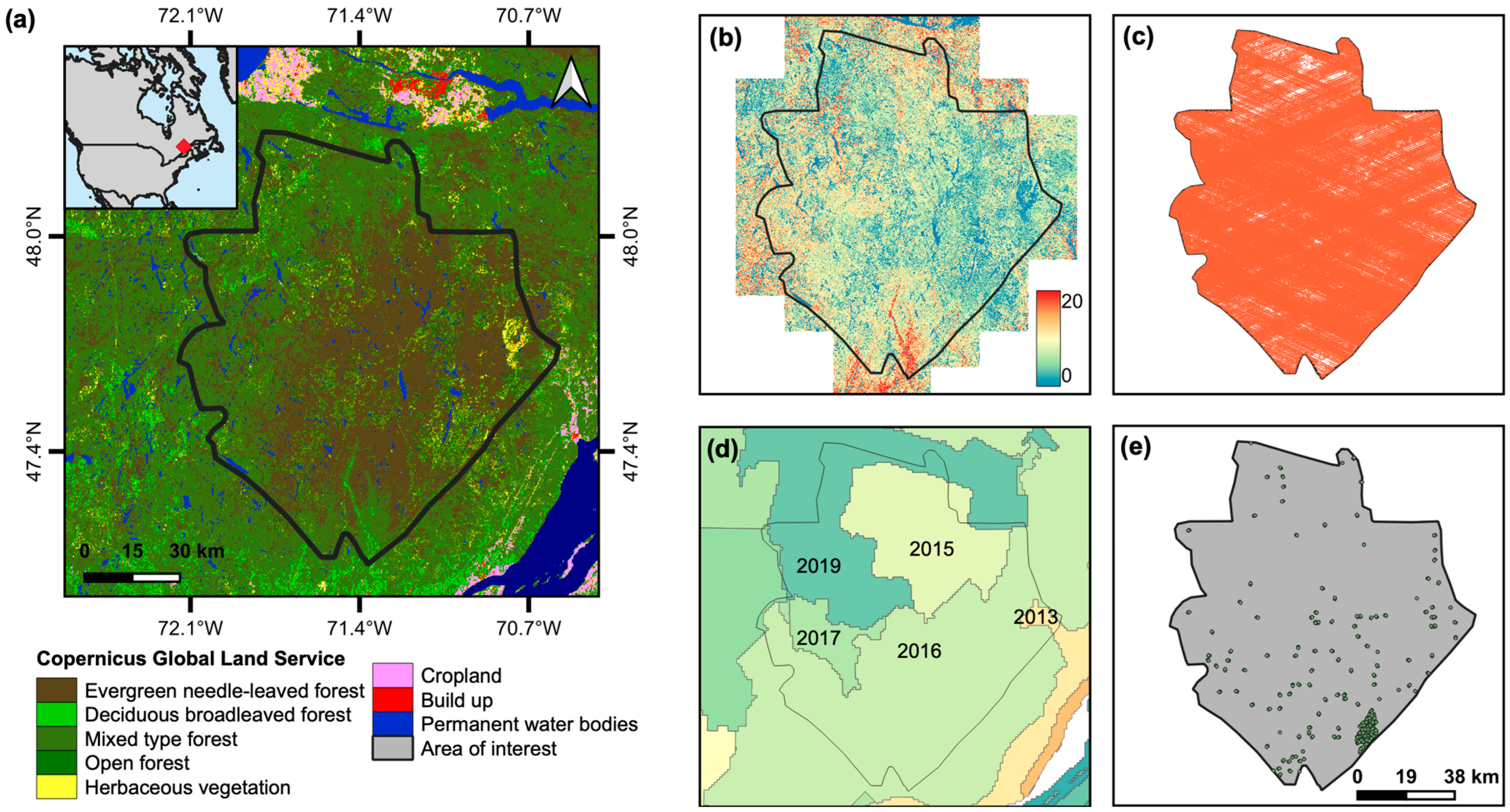
2.1. Study Area and Input Data

2.2. Data Preprocessing
2.3. Tree-Growth Estimation
2.4. Assessment of Tree-Growth Rates
3. Results
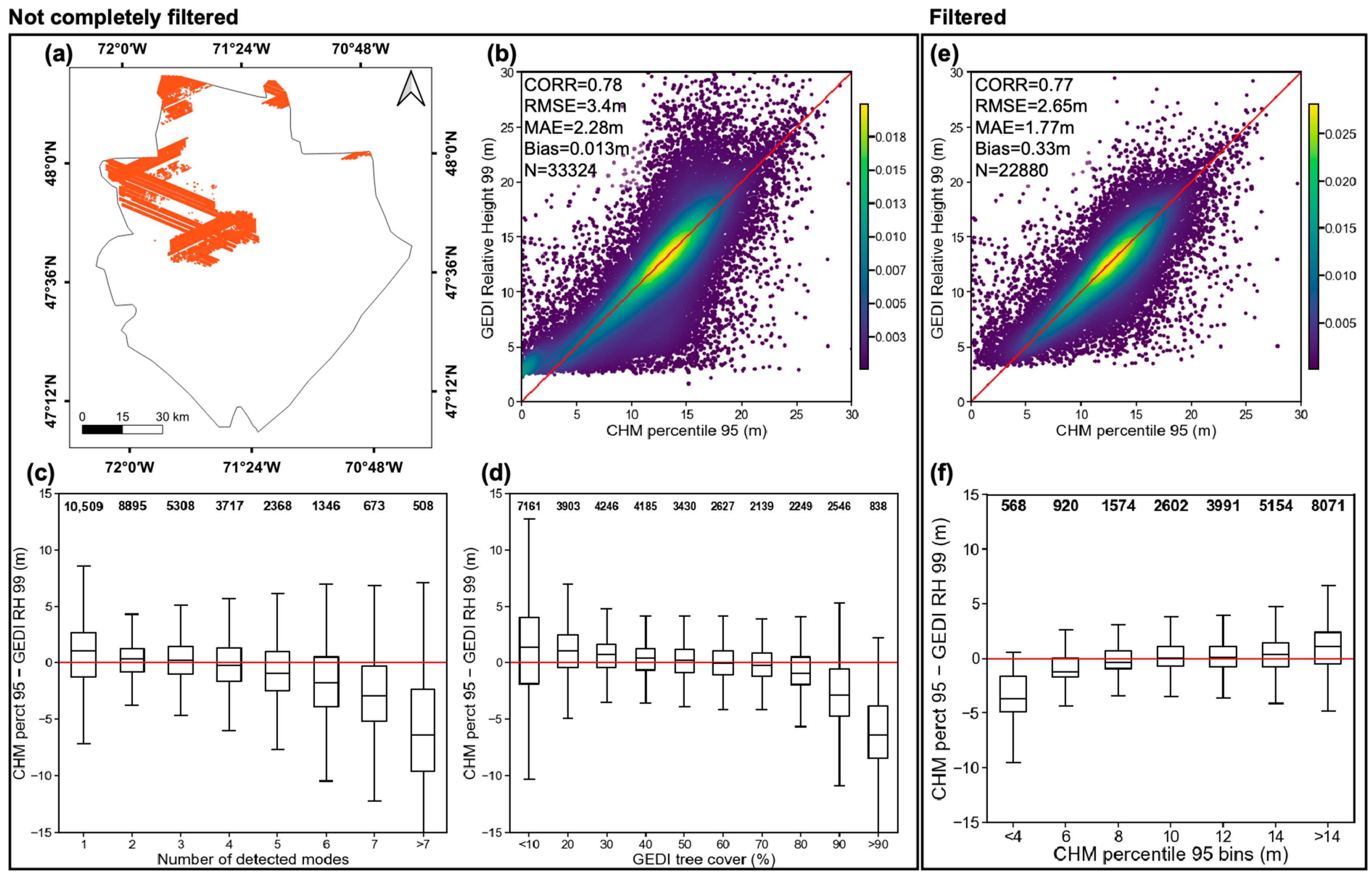
3.1. GEDI Footprint Accuracy Assessment
3.2. Correspondence of Aggregated GEDI RH and Mean CHM
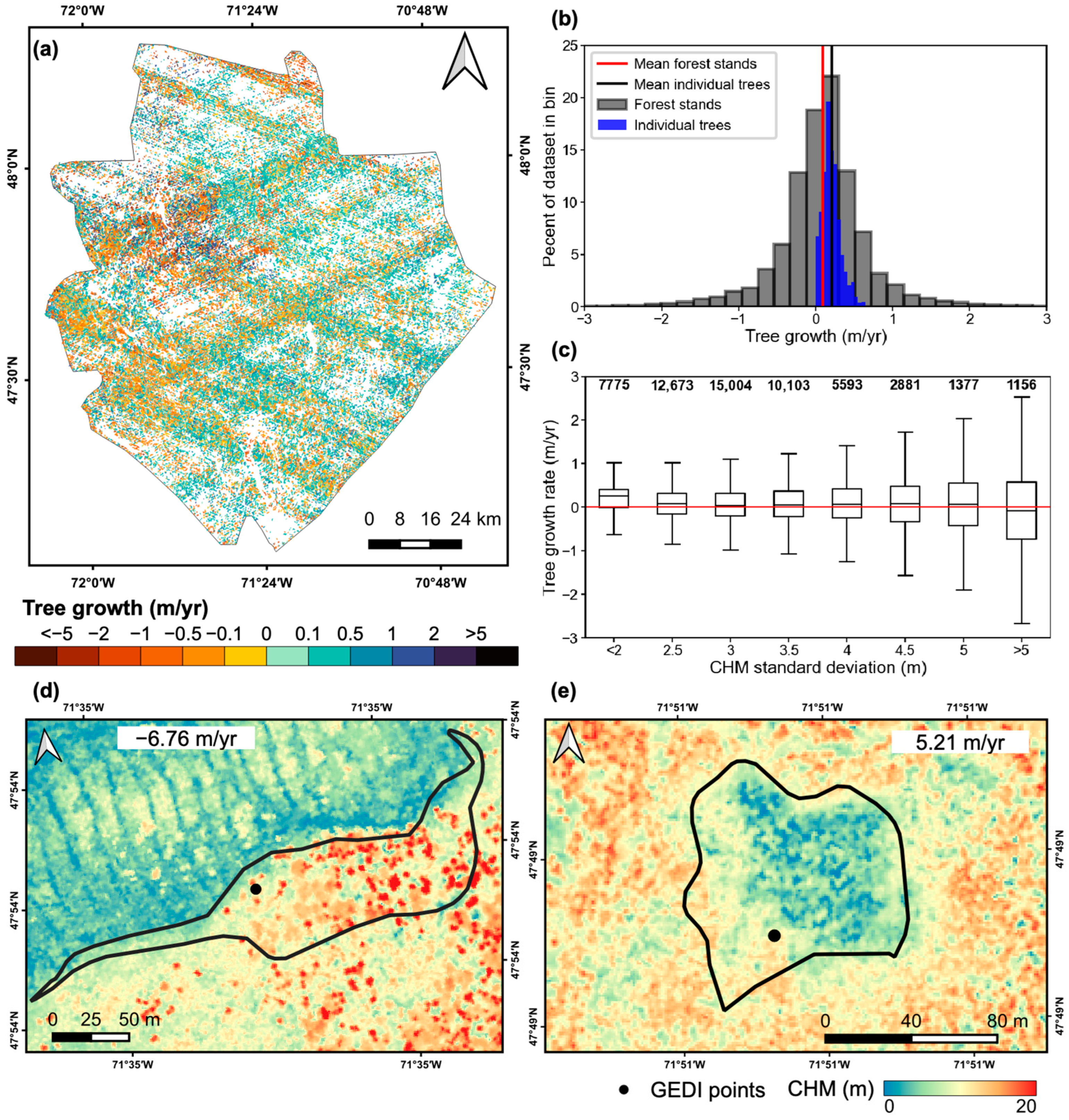
3.3. Tree-Growth Results
3.4. Patterns of Tree-Growth per Species, Forest Type, and Disturbances
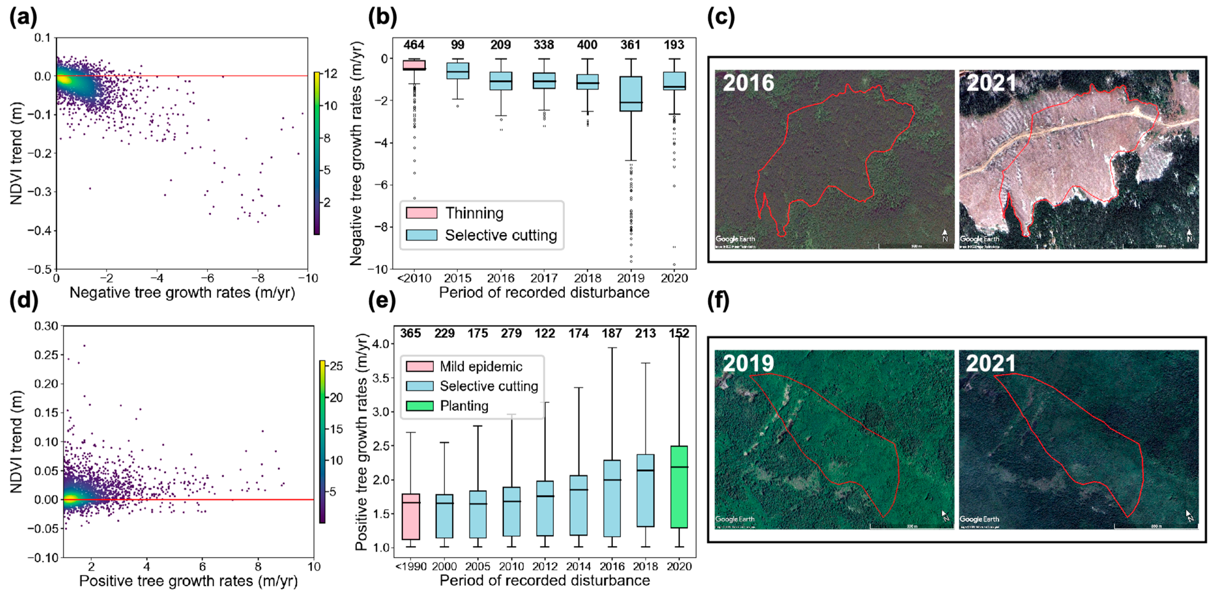
3.5. Evaluation of Extreme Tree-Growth Rates with NDVI
4. Discussion
4.1. Effects of GEDI Data Scarcity
4.2. Tree Growth in the Laurentides Reserve
5. Conclusions
Author Contributions
Funding
Data Availability Statement
Acknowledgments
Conflicts of Interest
References
- Neeff, T.; Piazza, M. How countries link forest monitoring into policy-making. For. Policy Econ. 2020, 118, 102248. [Google Scholar] [CrossRef]
- Herold, M.; Johns, T. Linking requirements with capabilities for deforestation monitoring in the context of the UNFCCC-REDD process. Environ. Res. Lett. 2007, 2, 045025. [Google Scholar] [CrossRef]
- Santilli, M.; Moutinho, P.; Schwartzman, S.; Nepstad, D.; Curran, L.; Nobre, C. Tropical deforestation and the Kyoto protocol. Clim. Chang. 2005, 71, 267–276. [Google Scholar] [CrossRef]
- Forneri, C.; Blaser, J.; Jotzo, F.; Robledo, C. Keeping the forest for the climate’s sake: Avoiding deforestation in developing countries under the UNFCCC. Clim. Policy 2006, 6, 275–294. [Google Scholar] [CrossRef]
- Akhtar-Schuster, M.; Stringer, L.C.; Erlewein, A.; Metternicht, G.; Minelli, S.; Safriel, U.; Sommer, S. Unpacking the concept of land degradation neutrality and addressing its operation through the Rio Conventions. J. Environ. Manag. 2017, 195, 4–15. [Google Scholar] [CrossRef]
- Hein, J.; Guarin, A.; Frommé, E.; Pauw, P. Deforestation and the Paris climate agreement: An assessment of REDD+ in the national climate action plans. For. Policy Econ. 2018, 90, 7–11. [Google Scholar] [CrossRef]
- Gren, I.M.; Aklilu, A.Z. Policy design for forest carbon sequestration: A review of the literature. For. Policy Econ. 2016, 70, 128–136. [Google Scholar] [CrossRef]
- Olander, L.P.; Gibbs, H.; Steininger, M.; Swenson, J.; Murray, B.C. Data and Methods to Estimate National Historical Deforestation Baselines in Support of UNFCCC REDD. Options 2007, 4. Available online: https://nicholasinstitute.duke.edu/ecosystem/land/data-and-methods-to-estimate-national-historical-deforestation-baselines-in-support-of-unfccc-redd (accessed on 16 February 2023).
- DeFries, R.; Achard, F.; Brown, S.; Herold, M.; Murdiyarso, D.; Schlamadinger, B.; de Souza, C. Earth observations for estimating greenhouse gas emissions from deforestation in developing countries. Environ. Sci. Policy 2007, 10, 385–394. [Google Scholar] [CrossRef]
- Dolan, K.; Masek, J.G.; Huang, C.; Sun, G. Regional forest growth rates measured by combining ICESat GLAS and Landsat data. J. Geophys. Res. Biogeosci. 2009, 114, 1–7. [Google Scholar] [CrossRef]
- Matula, R.; Knířová, S.; Vítámvás, J.; Šrámek, M.; Kníř, T.; Ulbrichová, I.; Svoboda, M.; Plichta, R. Shifts in intra-annual growth dynamics drive a decline in productivity of temperate trees in Central European forest under warmer climate. Sci. Total Environ. 2023, 905, 166906. [Google Scholar] [CrossRef]
- Lemprière, T.C.; Bernier, P.Y.; Carroll, A.L.; Flannigan, M.D.; Gilsenan, R.P.; McKenney, D.W.; Hogg, E.H.; Pedlar, J.H.; Blain, D. The Importance of Forest Sector Adaptation to Climate Change. 2008. Available online: http://dsp-psd.pwgsc.gc.ca/collection_2009/nrcan/Fo133-1-416E.pdf (accessed on 8 June 2023).
- Chen, H.Y.H.; Luo, Y. Net aboveground biomass declines of four major forest types with forest ageing and climate change in western Canada’s boreal forests. Glob. Chang. Biol. 2015, 21, 3675–3684. [Google Scholar] [CrossRef]
- Finer, M.; Novoa, S.; Weisse, M.J.; Petersen, R.; Mascaro, J.; Souto, T.; Stearns, F.; Martinez, R.G. Combating deforestation: From satellite to intervention. Science 2018, 360, 1303–1305. [Google Scholar] [CrossRef]
- Coops, N.C. Characterizing forest growth and productivity using remotely sensed data. Curr. For. Reports 2015, 1, 195–205. [Google Scholar] [CrossRef]
- Fagan, M.; Defries, R. Measurement and Monitoring of the World’s Forests: A Review and Summary of Remote Sensing Technical Capability, 2009–2015; Resources for the Future: Washington, DC, USA, 2015; Available online: https://www.rff.org/publications/reports/measurement-and-monitoring-of-the-worlds-forests-a-review-and-summary-of-remote-sensing-technical-capability-20092015/ (accessed on 21 February 2023).
- World Resources Institute. Global Forest Watch. 2022. Available online: https://www.globalforestwatch.org/ (accessed on 21 February 2023).
- Hansen, M.C.; Loveland, T.R. A review of large area monitoring of land cover change using Landsat data. Remote Sens. Environ. 2012, 122, 66–74. [Google Scholar] [CrossRef]
- Turubanova, S.; Potapov, P.; Hansen, M.C.; Li, X.; Tyukavina, A.; Pickens, A.H.; Hernandez-Serna, A.; Arranz, A.P.; Guerra-Hernandez, J.; Senf, C.; et al. Tree canopy extent and height change in Europe, 2001–2021, quantified using Landsat data archive. Remote Sens. Environ. 2023, 298, 113797. [Google Scholar] [CrossRef]
- Sinha, S.; Jeganathan, C.; Sharma, L.K.; Nathawat, M.S. A review of radar remote sensing for biomass estimation. Int. J. Environ. Sci. Technol. 2015, 12, 1779–1792. [Google Scholar] [CrossRef]
- Lehmann, E.A.; Caccetta, P.; Lowell, K.; Mitchell, A.; Zhou, Z.-S.; Held, A.; Milne, T.; Tapley, I. SAR and optical remote sensing: Assessment of complementarity and interoperability in the context of a large-scale operational forest monitoring system. Remote Sens. Environ. 2015, 156, 335–348. [Google Scholar] [CrossRef]
- Marshak, C.; Simard, M.; Denbina, M. Monitoring forest loss in ALOS/PALSAR time-series with superpixels. Remote Sens. 2019, 11, 556. [Google Scholar] [CrossRef]
- Solberg, S.; Hansen, E.H.; Gobakken, T.; Næssset, E.; Zahabu, E. Biomass and InSAR height relationship in a dense tropical forest. Remote Sens. Environ. 2017, 192, 166–175. [Google Scholar] [CrossRef]
- Hansen, E.H.; Gobakken, T.; Solberg, S.; Kangas, A.; Ene, L.; Mauya, E.; Næsset, E. Relative efficiency of ALS and InSAR for biomass estimation in a Tanzanian rainforest. Remote Sens. 2015, 7, 9865–9885. [Google Scholar] [CrossRef]
- Simard, M.; Fatoyinbo, L.; Smetanka, C.; Rivera-Monroy, V.H.; Castañeda-Moya, E.; Thomas, N.; Van Der Stocken, T. Mangrove canopy height globally related to precipitation, temperature and cyclone frequency. Nat. Geosci. 2019, 12, 40–45. [Google Scholar] [CrossRef]
- Denbina, M.; Simard, M.; Hawkins, B. Forest Height Estimation Using Multibaseline PolInSAR and Sparse Lidar Data Fusion. IEEE J. Sel. Top. Appl. Earth Obs. Remote Sens. 2018, 11, 3415–3433. [Google Scholar] [CrossRef]
- Santoro, M.; Cartus, O. Research pathways of forest above-ground biomass estimation based on SAR backscatter and interferometric SAR observations. Remote Sens. 2018, 10, 608. [Google Scholar] [CrossRef]
- Lefsky, M.A.; Cohen, W.B.; Harding, D.J.; Parker, G.G.; Acker, S.A.; Gower, S.T. Lidar remote sensing of above-ground biomass in three biomes. Glob. Ecol. Biogeogr. 2002, 11, 393–399. [Google Scholar] [CrossRef]
- Margolis, H.A.; Nelson, R.F.; Montesano, P.M.; Beaudoin, A.; Sun, G.; Andersen, H.-E.; Wulder, M.A. Combining satellite lidar, airborne lidar, and ground plots to estimate the amount and distribution of aboveground biomass in the boreal forest of North America. Can. J. For. Res. 2015, 45, 838–855. [Google Scholar] [CrossRef]
- Boudreau, J.; Nelson, R.F.; Margolis, H.A.; Beaudoin, A.; Guindon, L.; Kimes, D.S. Regional aboveground forest biomass using airborne and spaceborne LiDAR in Québec. Remote Sens. Environ. 2008, 112, 3876–3890. [Google Scholar] [CrossRef]
- Simard, M.; Pinto, N.; Fisher, J.B.; Baccini, A. Mapping forest canopy height globally with spaceborne lidar. J. Geophys. Res. Biogeosci. 2011, 116, 1–12. [Google Scholar] [CrossRef]
- Sothe, C.; Gonsamo, A.; Lourenço, R.B.; Kurz, W.A.; Snider, J. Spatially Continuous Mapping of Forest Canopy Height in Canada by Combining GEDI and ICESat-2 with PALSAR and Sentinel. Remote Sens. 2022, 14, 5158. [Google Scholar] [CrossRef]
- Tokola, T. Remote sensing concepts and their applicability in REDD+ monitoring. Curr. For. Rep. 2015, 1, 252–260. [Google Scholar] [CrossRef]
- Potapov, P.; Li, X.; Hernandez-Serna, A.; Tyukavina, A.; Hansen, M.C.; Kommareddy, A.; Pickens, A.; Turubanova, S.; Tang, H.; Silva, C.E.; et al. Mapping global forest canopy height through integration of GEDI and Landsat data. Remote Sens. Environ. 2021, 253, 112165. [Google Scholar] [CrossRef]
- Fayad, I.; Ienco, D.; Baghdadi, N.; Gaetano, R.; Alvares, C.A.; Stape, J.L.; Scolforo, H.F.; Le Maire, G. A CNN-based approach for the estimation of canopy heights and wood volume from GEDI waveforms. Remote Sens. Environ. 2021, 265, 112652. [Google Scholar] [CrossRef]
- Lang, N.; Kalischek, N.; Armston, J.; Schindler, K.; Dubayah, R.; Wegner, J.D. Global canopy height regression and uncertainty estimation from GEDI LIDAR waveforms with deep ensembles. Remote Sens. Environ. 2022, 268, 112760. [Google Scholar] [CrossRef]
- Dubayah, R.; Goetz, S.J.; Blair, J.B.; Fatoyinbo, T.E.; Hansen, M.; Healey, S.P.; Hofton, M.A.; Hurtt, G.C.; Kellner, J.; Luthcke, S.B. The Global Ecosystem Dynamics Investigation: High-resolution laser ranging of the Earth’s forests and topography. Sci. Remote Sens. 2020, 1, 100002. [Google Scholar] [CrossRef]
- National Academies of Sciences Engineering, and Medicine. Thriving on Our Changing Planet: A Decadal Strategy for Earth Observation from Space; The National Academies Press: Washington, DC, USA, 2018. [Google Scholar]
- Boucher, Y.; Grondin, P.; Noël, J.; Hotte, D.; Blouin, J.; Roy, G. Classification Des Écosystémes Et Répartition Des Forêts Mûres Et Surannées : Le Cas Du Projet Pilote D’aménagement Écosystémique De La Réserve Faunique Des Laurentides; Gouvernement du Québec, Ministère des Ressources naturelles et de la Faune, Direction de la recherche forestière: Quebec, QC, Canada, 2008. [Google Scholar]
- Ministère des Forêts de la Faune et des Parcs. Guide D’utilisation De La Carte Écoforestière Et Des Résultats D’inventaire Écoforestier Du Québec Méridional; Ministère Des Forêts, De La Faune Et Des Parcs, Secteur Des Forêts, Direction Des Inventaires Forestiers: Québec, QC, Canada, 2021.
- Ministère des Forêts de la Faune et des Parcs. Norme De Stratification Écoforestière Quatrième Inventaire Écoforestier Du Québec Méridional; Ministère Des Forêts De La Faune Et Des Parcs: Québec, QC, Canada, 2008. Available online: https://mffp.gouv.qc.ca/nos-publications/norme-stratification-ecoforestiere-quatrieme-inventaire/ (accessed on 9 March 2023).
- Buchhorn, M.; Smets, B.; Bertels, L.; Roo, B.D.; Lesiv, M.; Herold, M.; Fritz, S.; Tsendbazar, N.-E. Copernicus Global Land Service: Land Cover 100m: Collection 3: Epoch 2019: Globe. 2020. Available online: https://zenodo.org/record/3939050 (accessed on 10 March 2023). [CrossRef]
- Ma, Q.; Su, Y.; Guo, Q. Comparison of Canopy Cover Estimations from Airborne LiDAR, Aerial Imagery, and Satellite Imagery. IEEE J. Sel. Top. Appl. Earth Obs. Remote Sens. 2017, 10, 4225–4236. [Google Scholar] [CrossRef]
- Hopkinson, C.; Chasmer, L. Testing LiDAR models of fractional cover across multiple forest ecozones. Remote Sens. Environ. 2009, 113, 275–288. [Google Scholar] [CrossRef]
- Sexton, J.O.; Bax, T.; Siqueira, P.; Swenson, J.J.; Hensley, S. A comparison of lidar, radar, and field measurements of canopy height in pine and hardwood forests of southeastern North America. For. Ecol. Manag. 2009, 257, 1136–1147. [Google Scholar] [CrossRef]
- Helsel, D.R.; Hirsch, R.M.; Ryberg, K.R.; Archfield, S.A.; Gilroy, E.J. Statistical Methods in Water Resources: U.S. Geological Survey Techniques and Methods; U.S. Department of the Interior: Reston, VA, USA; U.S. Geological Survey: Reston, VA, USA, 2020; Chapter A3.
- Theil, H. A Rank-Invariant Method of Linear and Polynomial Regression Analysis. Proc. R. Netherlands Acad. Sci. 1950, 53, 345–381. [Google Scholar] [CrossRef]
- Wilcox, R.R. A Note on the Theil-Sen Regression Estimator When the Regressor Is Random and the Error Term Is Heteroscedastic. Biometrical J. 1998, 40, 261–268. [Google Scholar] [CrossRef]
- Fernandes, R.; Leblanc, S.G. Parametric (modified least squares) and non-parametric (Theil–Sen) linear regressions for predicting biophysical parameters in the presence of measurement errors. Remote Sens. Environ. 2005, 95, 303–316. [Google Scholar] [CrossRef]
- Yu, X.; Hyyppä, J.; Kaartinen, H.; Maltamo, M. Automatic detection of harvested trees and determination of forest growth using airborne laser scanning. Remote Sens. Environ. 2004, 90, 451–462. [Google Scholar] [CrossRef]
- Bowman, D.M.J.S.; Brienen, R.J.W.; Gloor, E.; Phillips, O.L.; Prior, L.D. Detecting trends in tree growth: Not so simple. Trends Plant Sci. 2013, 18, 11–17. [Google Scholar] [CrossRef] [PubMed]
- Sardans, J.; Peñuelas, J. Tree growth changes with climate and forest type are associated with relative allocation of nutrients, especially phosphorus, to leaves and wood. Glob. Ecol. Biogeogr. 2013, 22, 494–507. [Google Scholar] [CrossRef]
- Gorelick, N.; Hancher, M.; Dixon, M.; Ilyushchenko, S.; Thau, D.; Moore, R. Google Earth Engine: Planetary-scale geospatial analysis for everyone. Remote Sens. Environ. 2017, 202, 18–27. [Google Scholar] [CrossRef]
- Holben, B.N. Characteristics of maximum-value composite images from temporal AVHRR data. Int. J. Remote Sens. 1986, 7, 1417–1434. [Google Scholar] [CrossRef]
- Quiros, E.; Polo, M.E.; Fragoso-Campon, L. GEDI Elevation Accuracy Assessment: A Case Study of Southwest Spain. IEEE J. Sel. Top. Appl. Earth Obs. Remote Sens. 2021, 14, 5285–5299. [Google Scholar] [CrossRef]
- Wang, C.; Elmore, A.J.; Numata, I.; Cochrane, M.A.; Shaogang, L.; Huang, J.; Zhao, Y.; Li, Y. Factors affecting relative height and ground elevation estimations of GEDI among forest types across the conterminous USA. GISci. Remote Sens. 2022, 59, 975–999. [Google Scholar] [CrossRef]
- Dorado-Roda, I.; Pascual, A.; Godinho, S.; Silva, C.A.; Botequim, B.; Rodríguez-Gonzálvez, P.; González-Ferreiro, E.; Guerra-Hernández, J. Assessing the accuracy of gedi data for canopy height and aboveground biomass estimates in mediterranean forests. Remote Sens. 2021, 13, 2279. [Google Scholar] [CrossRef]
- Roy, D.P.; Kashongwe, H.B.; Armston, J. The impact of geolocation uncertainty on GEDI tropical forest canopy height estimation and change monitoring. Sci. Remote Sens. 2021, 4, 100024. [Google Scholar] [CrossRef]
- Burns, R.M.; Honkala, B.H. Silvics of North America: 1. Conifers; 2. Hardwoods; U.S. Department of Agriculture, Forest Service: Washington, DC, USA, 1990; Volume 2.
- Pothier, D.; Savard, F. Actualisation Des Tables De Production Pour Les Principales Espèces Forestières Du Québec; Ministère des Ressources Naturelles, Government of Quebec: Quebec, QC, Canada, 1998.
- Dubayah, R.O.; Blair, J.B.; Goetz, S.; Fatoyinbo, L.; Hansen, M.; Healey, S.; Hofton, M.; Hurtt, G.; Kellner, J.; Luthcke, S.; et al. GLOBAL Ecosystem Dynamics Investigation (GEDI) Level 2 User Guide. 2021, 3, 1–25. Available online: https://lpdaac.usgs.gov/documents/986/GEDI02_UserGuide_V2.pdf (accessed on 10 March 2023).
- Milenković, M.; Reiche, J.; Armston, J.; Neuenschwander, A.; De Keersmaecker, W.; Herold, M.; Verbesselt, J. Assessing Amazon rainforest regrowth with GEDI and ICESat-2 data. Sci. Remote Sens. 2022, 5, 100051. [Google Scholar] [CrossRef]
- Guerra-Hernández, J.; Pascual, A. Using GEDI lidar data and airborne laser scanning to assess height growth dynamics in fast-growing species: A showcase in Spain. For. Ecosyst. 2021, 8, 14. [Google Scholar] [CrossRef]


| Parameter | Threshold |
|---|---|
| Degraded flag | ≠0 |
| Quality flag | ≠0 |
| Number of detected modes | =0 OR >7 |
| Elevation of the highest return—TanDEM-X elevation | <−20 m OR >20 m |
| Landsat water persistence | >80 |
| Total canopy cover from GEDI | <5% OR >90% |
| Total Energy | <2000 |
| Last mode energy ÷ energy total | <0.195 |
| For waveforms with only one mode: last mode energy | <2000 |
| For waveforms with only one mode: zcross local energy | <150 |
| Dataset | Tree Growth (m/Year) | Samples | |||
|---|---|---|---|---|---|
| Mean | Min | Max | SD | ||
| All forest stands with data | 0.09 | −9.78 | 11.22 | 0.76 | 56,562 |
| Forest stand with values of 0–1 m/year | 0.32 | 0 | 1 | 0.23 | 31,325 |
| Individual trees from permanent plots | 0.21 | 0 | 0.92 | 0.12 | 3579 |
Disclaimer/Publisher’s Note: The statements, opinions and data contained in all publications are solely those of the individual author(s) and contributor(s) and not of MDPI and/or the editor(s). MDPI and/or the editor(s) disclaim responsibility for any injury to people or property resulting from any ideas, methods, instructions or products referred to in the content. |
© 2023 by the authors. Licensee MDPI, Basel, Switzerland. This article is an open access article distributed under the terms and conditions of the Creative Commons Attribution (CC BY) license (https://creativecommons.org/licenses/by/4.0/).
Share and Cite
Parra, A.; Simard, M. Evaluation of Tree-Growth Rate in the Laurentides Wildlife Reserve Using GEDI and Airborne-LiDAR Data. Remote Sens. 2023, 15, 5352. https://doi.org/10.3390/rs15225352
Parra A, Simard M. Evaluation of Tree-Growth Rate in the Laurentides Wildlife Reserve Using GEDI and Airborne-LiDAR Data. Remote Sensing. 2023; 15(22):5352. https://doi.org/10.3390/rs15225352
Chicago/Turabian StyleParra, Adriana, and Marc Simard. 2023. "Evaluation of Tree-Growth Rate in the Laurentides Wildlife Reserve Using GEDI and Airborne-LiDAR Data" Remote Sensing 15, no. 22: 5352. https://doi.org/10.3390/rs15225352
APA StyleParra, A., & Simard, M. (2023). Evaluation of Tree-Growth Rate in the Laurentides Wildlife Reserve Using GEDI and Airborne-LiDAR Data. Remote Sensing, 15(22), 5352. https://doi.org/10.3390/rs15225352


