Article

Posidonia oceanica Cartography and Evolution of the Balearic Sea (Western Mediterranean)

by
Laura del Valle Villalonga
1,*,
Guillem Xavier Pons
2 and
Marcial Bardolet
3
1
Earth Sciences Research Group, Universitat de les Illes Balears, Ctra. de Valldemossa, km 7.5, 07122 Palma, Spain
2
Department of Geography, Universitat de Les Illes Balears, Ctra. de Valldemossa, km 7.5, 07122 Palma, Spain
3
Institut Balear de la Natura (IBANAT), 07009 Palma, Spain
*
Author to whom correspondence should be addressed.
Remote Sens. 2023, 15(24), 5748; https://doi.org/10.3390/rs15245748
Submission received: 2 October 2023 / Revised: 10 December 2023 / Accepted: 12 December 2023 / Published: 15 December 2023
(This article belongs to the Special Issue Advances in Remote Sensing in Coastal Geomorphology Ⅱ)

Abstract

:
The Balearic coastline presents an environmental and biological heterogeneity, which confers great complexity on the marine environment and treasures important biodiversity, both at the level of species and marine communities. The endemic phanerogam of the Mediterranean Sea, Posidonia oceanica, holds a pivotal role in maintaining high biodiversity, warranting protection as stipulated in the Posidonia Decree 25/2018. The purpose of this study is to provide quantitative criteria that will allow the delimitation of areas with Posidonia oceanica for conservation and to aid planning and management of this species, contributing to the reduction of biodiversity loss caused by anthropogenic impacts and global change. Utilizing a comprehensive approach, the study employs photo interpretation of aerial photographs taken at depths between 0 and 5 m, data from Side-Scan Sonar (SSS) campaigns, reprocessing information from the LIFE Posidonia project at depths between 20 and 30 m, and targeted sampling using Remote Operated Vehicles (ROV) and ocular recognition at strategic points. The research not only seeks to assess the present state of the phanerogam but also analyzes its evolution, establishing a technological database for consultation and integrated analysis. This database facilitates effective management by tracking habitat changes, representing a significant contribution to the understanding of the impact of global change on ecosystems through Geographical Information Technologies (TIGs).

1. Introduction

Posidonia oceanica, an endemic phanerogam of the Mediterranean Sea [1], forms extensive meadows around the Balearic Islands, known as submarine forests. These meadows are essential for the ecosystem as they host a diverse range of species and provide crucial benefits. They serve as shelters for numerous organisms, produce oxygen daily while absorbing carbon dioxide, and generate a significant amount of biomass annually. Moreover, they can form long-lasting barrier reefs or seagrass. Additionally, these meadows play a vital role in defining and protecting beaches. During winter, the accumulation of leaves on the beach, known as banquettes, stabilizes the seafloor and mitigates the impact of waves on the coast. Furthermore, the shells of the epiphytic calcareous organisms on P. oceanica leaves contribute to the formation of whiter beaches [2,3,4].
P. oceanica is the dominant seagrass species in the Mediterranean, where this endemic species covers about 50,000 km2 above 45 m depth (estimated by [5]). This species develops extensive meadows, which are structurally and topographically complex, as the growth of the vertical rhizomes of the plant, acting along millenary time scales [6], develops reefs. These meadows represent one of the most productive ecosystems in the Mediterranean Sea, with a net primary production of about 1000 g DW m’ year-1 [7]. The clear waters and shallow slopes characteristic of the Balearic Islands allow the development of extensive P. oceanica beds, which probably represent the dominant marine ecosystem on the coast of the Balearic Islands. Yet, our knowledge on the extent, status, ecology, and functions of these important ecosystems in the Balearic Islands is still meager. Moreover, the body of knowledge from before the 21st century on the ecology of these meadows, including information on their presence in the Cabrera island [8] and the Bay of Palma [9], the impacts of aquaculture operations at Fornells Bay (Menorca [10]), carbonate production in Pollença Bay [11], and some aspects of their palaeodynamics [12], is scarce. Seagrass ecosystems are under pressure worldwide [13], including the Balearic Islands (e.g., [14]), so the conservation of these important ecosystems calls for increased efforts to understand their ecology and role in the ecosystem, as well as to formulate effective conservation strategies [15].
P. oceanica is highly sensitive to environmental changes, which makes it an excellent indicator of water quality. Recognizing its significance, it has been designated a habitat of priority interest for the EU since 1992 [16]. Various regulations, such as Decree 25/2018 [17], have been put in place to protect and conserve P. oceanica. However, despite these protective measures, this vital community faces threats due to an increase in activities in the Balearic waters, endangering its conservation status. Anchoring, uncontrolled mooting of boats, trawling, beach regeneration, desalination plants, and other direct impacts pose significant risks.
In some parts of the Balearic Islands, up to 40% of them have disappeared, mainly due to the damage caused by the anchors of recreational boats. According to the results of a study carried out by researchers, the extent of Posidonia has been reduced by between 13% and 38% since 1960, and since the 1990s, the density of Posidonia bundles has decreased by 50 %. That is why it is very important to have an updated, detailed cartography [18].
To address this situation, the Balearic government approved Decree 25/2018 [17], aiming to ensure the compatibility of human activities with the protection of P. oceanica and its habitat. In order to achieve this, it is necessary to conduct a comprehensive, continuous, and high-quality cartography of P. oceanica surrounding the Balearic Islands, utilizing the latest and most advanced technologies available. This includes photo interpretation of aerial photographs in shallow areas (0–5 m), SSS (Side-Scan Sonar) campaigns, sampling using ROVs, and others. The initial contribution, presented in “Mapping of the Marine Habitats of the Balearic Islands: Compilation of Layers and Benthic Communities [19],” underscores the imperative to enhance and expand current cartography. This pertains not only to the broader spectrum of bionomic considerations but also to the comprehensive evaluation of habitat conservation statuses. The present study emphasizes the lack of cartography information on the Serra de Tramuntana coastline and the necessity to enhance and update knowledge about habitat conservation in vulnerable areas such as the Bays of Pollença, Alcúdia, and Fornells, among others.
One of the first results obtained with this project is the continuous mapping of the seabed of the entire Balearic Islands and the approximation of the state of conservation of this seabed based on bibliographic information. Secondly, this work has allowed us to detect information gaps and discriminate information that is outdated, both at a cartographic and biological level.
The final map of the Balearic Islands includes a total of 55 habitats mapped over an area of 5067.67 km2 of seabed, ranging from 0 to 50 m of practically all the seabed that surrounds the islands, up to 400 m in the channel of Menorca and up to 100 m in the Mallorca canal. This surface represents 22% of the surface of the Balearic Sea (up to 700 m deep) and 40% of the continental shelf of the Balearic Islands (up to 200 m). Partial results were also published for the island of Mallorca [20].
In this first global approximation, the predominant marine habitat is P. oceanica, with an area of 459.77 km2. However, large areas continued without data mapping (for example, Serra de Tramuntana region).
Therefore, the primary objective of this work is to accurately determine the precise location of P. oceanica in the Balearic Sea, specifically between 0 and 35 m, including the Serra de Tramuntana region. This research also aims to evaluate the evolution and conservation status of P. oceanica meadows, ultimately leading to the development of an effective management plan.

Study Area

The Balearic Sea is a subdivision of the western basin of the Mediterranean Sea, located between the Balearic Islands (Mallorca, Menorca, Eivissa, and Formentera) and the Spanish coast (Figure 1). It is limited in the southwest by the cape of Sant Antoni (38°50′N–0°12′E) and extends to the cape of Barbaria in the extreme southwest of Formentera. In the southeast of Formentera coast, it extends from Punta Roja, the eastern end, to the southern Cabrera (39°7′N–2°54′E) and the islet of l’Aire at the extreme south of Menorca, and from the northwest of the east coast of Menorca to cape Favàritx (40°0′N–4°14′E) until the San Sebastián cape (14°54′N–3°10′E).
The study area of the Balearic Sea includes the marine platform that surrounds the Balearic Islands from 0 to 35 m deep, including the islets. When P. oceanica is observed, this marine phanerogam is included in the List of Wild Species under the Special Protection Regime of the Balearic Islands [21] and the Spanish Catalog of Endangered Species [22]. It is also listed in Annex I of the Berne Convention [23], Annex II of the Barcelona Convention [24], and Annex I of Directive 92/43/EEC on the conservation of natural habitats and wild fauna and flora (as a habitat) [16].
P. oceanica is an endemic marine phanerogam of the Mediterranean, similar to terrestrial plants with leaves, flowers, and fruits, but it lives permanently submerged between the surface and 30 m deep, where there is still enough light to allow it to perform photosynthesis. In places where the transparency of the waters is greater, such as the Balearic Archipelago or the Eastern Mediterranean, the distribution of this species can reach depths of up to 40–45 m [25,26].

2. Methods

The P. oceanica cartography of all the Balearic Islands presented in this study is the result of the use of different techniques (Figure 2).
Photo interpretation of aerial photographs between 0 to 5 m deep; digitalization and photo interpretation based on the orthophotos of the National Aerial Orthophotography Plan 2018/19, supported by all previous coverages available.
Side-Scan Sonar campaign (SSS) between 0 to 35 m: through 2 sonar models with a frequency range between 100–500 kHz and 500–900 kHz, and the use of SonarWiz v7 software for data acquisition.
Reprocessing of available information from the LIFE Posidonia project between 20 and 30 m deep: bionomic cartography carried out in the LIFE Posidonia project of the Balearic Islands (LIFE00/NAT/E/7303).
In the case of the islands of Eivissa and Formentera, a new cartography was also prepared based on the following works: collection and analysis of the information available in the study area of the Socioenvironmental Observatory of Menorca and Natural History Society of the Balearic Islands [19], Consell de Eivissa (Calas de Ibiza, 2018), OCEANSNELL (reference cartography in Formentera, 2016), LIFE Posidonia Project (2010) and Ecocartography (Ministerio de Agricultura, Pesca y Alimentación, 2008).
Finally, the government of the Balearic Islands carried out a punctual sampling campaign to check the correct identification of marine habitats in the priority areas for inconsistencies, etc., with a ROV (underwater Drone) and a bathyscope.
Therefore, an inventory and compilation of the existing cartography were carried out; photo interpretation between 0 and 5 m deep, a program of specific sampling, a Side-Scan Sonar campaign on the island of Majorca between 0 and 30 m deep (detailed information on the typology of the funds and the limits determined with a resolution of 1 m, carried by different companies contracted by the government of the Balearic Islands to carry out field work [27]); the reprocessing of the information available from the LIFE Posidonia Project in Mallorca, between 20 and 30 m deep and processing and integration of the cartography.
For prospecting work with Side-Scan Sonar, a DGPS was used. It is an optimal differential positioning receiver for bathymetric and geophysical surveys, thanks to its high resolution and 20 kHz position update. The SBAS, BEACON and OMNISTAR differential corrections are applied to this receiver. At the same time, it supports RTK corrections up to 50 cm. Navigation for plotting the campaign line plan was carried out using the Hypack 2018 v1.18.1.0 Software. This software provides position and route details on high-resolution color screens. The operator enters track indication details, seabed features and risk areas, which can also be recorded and viewed on screen to aid in vessel positioning. Navigation and positioning data are reviewed and evaluated before positions are calculated and quality indicators are generated. Said navigation was executed on a plan of lines of work generated in the office, which were distributed throughout the field of study to cover the greatest possible extension. It is of great importance to emphasize that this extension was carried out being aware of the limitations that work at sea entails, such as the maneuverability of the vessel, unforeseen underwater events (shoals or submerged rocks), lack of space in coves and bays, etc.
For the acquisition of indirect data, two 500–900 kHz dual-frequency Side-Scan Sonar (SSS) units were used to appreciate the different types of bottom and the limits between them with a high degree of detail and thus achieve a mosaic with resolution of pixels of the order of 0.1 × 0.1 m (Figure 3).
During field work, the SSS was coupled to a “fish” towed by a boat. In order for the geopositioning of the transects to correspond as closely as possible to reality, a correction was applied to suppress the distance between the “fish” and the boat, which is where the GPS system is located.
The sonar is composed of a torpedo-shaped underwater vehicle with two transducers, a Transceiver and Processing Unit (TPU) from which the acoustic pulses are generated and a Kevlar cable that tows the equipment and transmits the data. The records are sent to a PC for viewing and storage using the appropriate software. The reflection of the signal coming from the bottom is captured by the same transducers, amplified and transmitted through the towline to the recorder, where the corresponding signal is digitized and sent to the PC where the appropriate software processes and stores it.
The data acquisition was carried out with the specific software, SonarWiz 7, which allows the data to be acquired in real time and the data files to be recorded every minute for subsequent processing. While observing the computer screen with real-time acquisition, both lengths and heights of objects can be measured with great precision, while complex areas can be magnified for further study. For the correct use and geographical orientation of the sedimentary forms and other types of bottom, as well as other objects found, a post processing of the image was carried out. The depth of the SSS with respect to the bottom was regulated so that the maximum sweep range was 75 m per band, and it was ensured that there was only a 10–15% overlap between adjacent transects.

2.1. Side-Scan Sonar Data Processing

Once the raw Side-Scan Sonar files were obtained by the field teams in XTF (eXtended Triton Format) format, they were processed with the SonarWiz7 software. This software allows the visualization, edition and treatment of these files, therefore it was used to eliminate the sheet of water from all the data (Bottom track), correct and smooth navigation, apply image filters, and export of the data in the form of a georeferenced mosaic. The post processing was carried out with the SonarWiz7 software from Chesapeake, with the correction of the range, correction of the navigation, application of filters and finally, the composition of the mosaics (reflectivity map in photographic form of the background).
The integration of all the previously mentioned raw information was carried out with the specific software ArcGis 10.4. This software allows the superimposition of different sources of georeferenced information, which is necessary for the digitization of the different morphologies of the seabed. The digitization of the limits of the seagrass meadows was carried out with the highest possible precision and at a minimum spatial scale of 1:800. All bald spots, voids and channels of relevant size within the identified meadows were represented. When digitizing marine phanerogams observed as discrete spots, a minimum area of 100 m2 was considered. However, in the majority of instances, the entire entity was meticulously represented, distinctly delineated from its surroundings, and characterized according to one of the established categories.

2.2. Reprocessing Methodology

In order to process and analyze the information correctly, the layers were projected to the ETRS89 UTM Zone 31 projection system, applying the transformation “ED50 to WGS84 NTv2 Baleares”. Subsequently, the original topology was reviewed and corrected in all complete layers, covering the entire surface. In each layer, the original information was preserved, and the following fields were created in their corresponding attribute tables. All the geometry errors that the original layers had, such as overlaps and gaps between polygons, were debugged. Processing and integration of the cartography: All the cartography was integrated in a single layer by grids.

3. Results

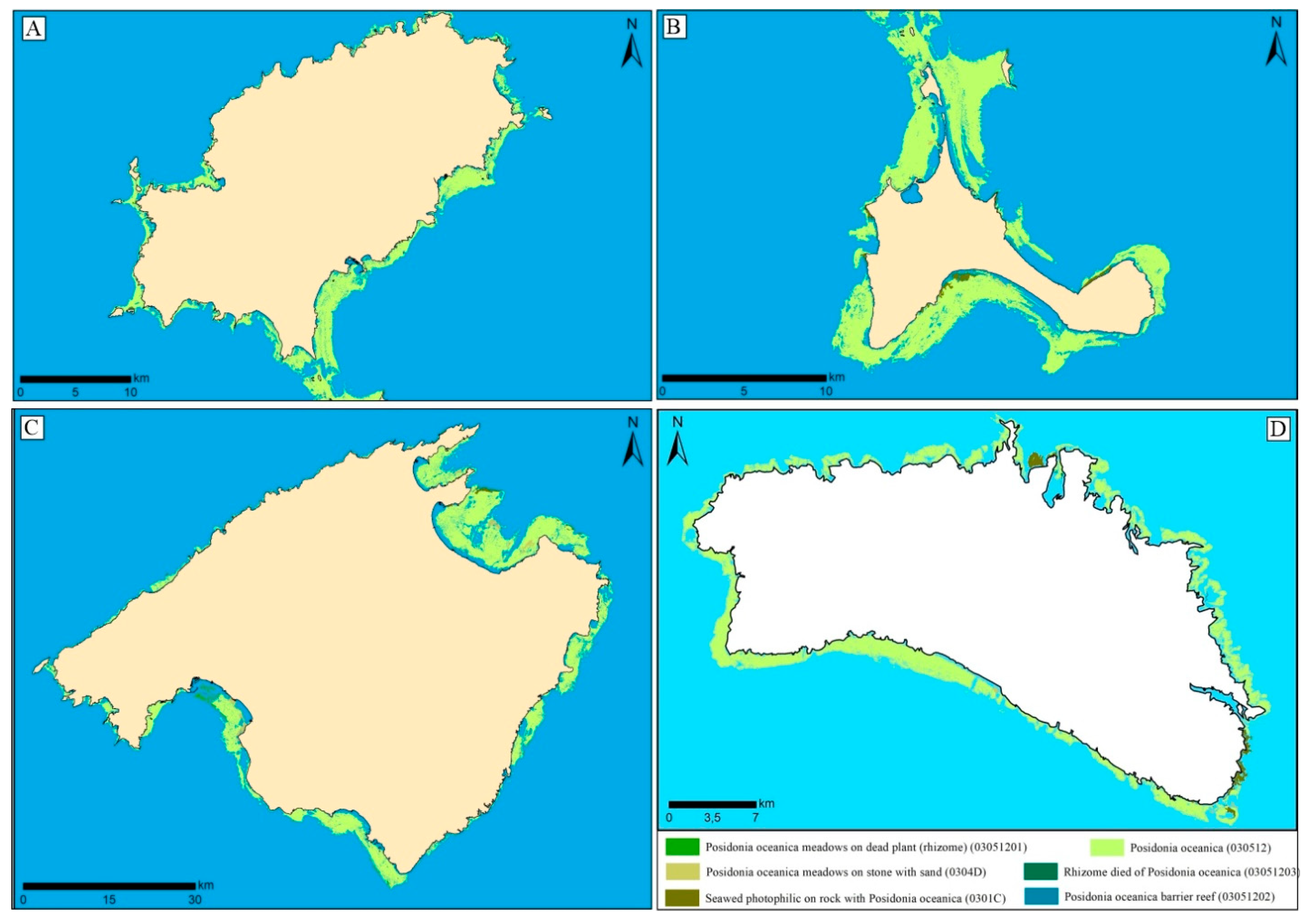
3.1. Cartography of Posidonia oceanica

The final product is the generation of homogeneous, continuous, and high-quality cartography of marine habitats, especially P. oceanica, which surrounds the Islands of Mallorca, Menorca, Eivissa, and Formentera, ranging from the coastline to approximately 35 m deep (Figure 4A–D). In addition, the data obtained by SSS have a resolution of the order of 0.2 m, allowing differentiation of the different types of funds and the precise determination of their limits.
The results are shown in Table 1.
The total area of the habitats containing P. oceanica in the study area is 592.82 km2, surpassing [27] the suggested area of 375 km2 by 93.40%. The final cartography, a result of diverse methods, including SSS techniques, photo interpretation, and GIS corrections, reveals a mapped P. oceanica area of 553.68 km2 between 0 and 35 m deep in the Balearic Sea around the Balearic Islands (Table 1). Especially, an area of 135.40 km2 was mapped in the islands of Eivissa and Formentera (Figure 4A,B), 338.92 km2 in Mallorca (Figure 4C), and 79.37 km2 in Menorca (Figure 4D).
Figure 5 illustrates a substantial shift in the Alcanada area, previously dominated by P. oceanica, now characterized by a prevalence of photophilic algae. Numerous voids, notably elongated and some ellipsoid in shape, between 1 and 3 m by 2 and 3 m, are evident.
In the western Bay of Palma (Figure 6), a 2 km long by 1 km wide area of dead P. oceanica rhizome (03051203) is observed, surrounded by meadows on dead plants (rhizome) covering 3 by 3 km, indicative of degradation.
The cartography in Cala Pudent unveils a distinct 1.17 km long and 1 m wide line and voids parallel to the coast in the western sector of the Bay of Palma, about 2 km long and 2 m wide.
For the first time, a detailed mapping of the Serra de Tramuntana marine platform between 0 and 35 m depth was conducted (Figure 7 and Figure 8). Figure 7 displays the P. oceanica map in Pollença Bay and part of the Serra de Tramuntana, showcasing metric-sized holes within the mapped area. Notably, there are 4 km-sized voids with very rectilinear shapes. The cartography also identifies areas where Posidonia returns to colonize on top of dead rhizomes (03051201). The cartography of the Serra de Tramuntana reveals a significant presence of photophilic seaweed on rocks with P. oceanica (0301C), and P. oceanica (030512) is observed in isolated spots or continuous meadows on stone with sand (0304D). Notably, P. oceanica (030512) presence is low in the Port of Sóller.

3.2. Conservation of Posidonia oceanica

An evaluation of the conservation status of P. oceanica was conducted based on the sampling program results for dead bushes (Figure 9A–D). The presence of dead bushes or areas of dead rhizome without foliar apparatus indicates meadow regression, providing crucial information about conservation and evolution.
In Eivissa, the Sant Antonio Bay reflects a highly degraded bottom with no P. oceanica presence. Formentera exhibits a well-preserved P. oceanica meadow, with dead plants identified only in Platja d’es Mitjorn and Cala en Baster (Figure 9A).
Mallorca, along with Eivissa, exhibits the worst P. oceanica meadow conservation. Eight zones, including the Pollença Bay and Alcanada area, show the presence of dead plants (Figure 5). The Pollença Port area has a degraded background, making cartography challenging. The Formentor Beach displays medium-low P. oceanica conservation, with identified patches of dead plants (Figure 7). In Sóller Port (Figure 8), some patches of dead plants were identified, though more grassland was found than initially thought.
Along the north coast of Menorca (Figure 9D), various locations with dead plants were identified, with Cala en Tusqueta being the most impacted. The presence of Cymodocea nodosa competing for space is notable. The importance of preserving areas of dead plants for P. oceanica regeneration is observed on this island.

4. Discussion

The comprehensive mapping of P. oceanica meadows through remote sensing has been the focus of various studies across the Mediterranean [28,29,30,31,32]. However, none have achieved the level of coverage and precision demonstrated in this research. The marine habitats of Spain, as outlined in the interpretive guide [33], exhibit significant environmental and biological heterogeneity, particularly evident in the Balearic Islands. These islands showcase diverse features, such as maërl beds, expansive seagrass meadows, underwater canyons such as Son Bou, and sedimentary bottoms of coves such as s’Estany des Peix, Fornells, or Addaia [34], hosting formations practically unique in the Mediterranean.
The susceptibility of coastal environments to threats such as climate change, marine pollution, overfishing, and anthropogenic activities leads to dynamic changes, resulting in habitat loss, introduction of non-native species, and degradation of coastlines [33]. Subsequent evaluations will play a crucial role in quantifying the impact of anthropogenic activities and global changes on biodiversity.
The historical backdrop reveals that oceanographic efforts along the Balearic coasts commenced in the 18th century, gaining momentum in the 20th century with comprehensive descriptions of benthic ecosystems [35]. Notably, the commitment to seabed studies was underscored by the Balearic Islands government commissioning the CEAB-CSIC for studies in protected areas [36,37,38]. Throughout all these centuries, a multitude of studies have been carried out that have allowed us to synthesize and describe the different types of habitats that we find in the entire Balearic Archipelago [39,40,41,42,43]. Despite centuries of research, the precision achieved in the cartography of P. oceanica in the Balearic Sea, totaling 553.68 km2, is unparalleled.
The mapped areas reveal P. oceanica as disseminated spots with varying sizes and shapes, often exhibiting elongated or ellipsoid forms. Notably, areas with multiple voids in close proximity suggest potential damage from indiscriminate anchorage or illegal activities, prevalent in regions with high anthropic pressure.
Boat anchorages pose significant threats to P. oceanica meadows due to anchor movements and chain interactions. A notable case is the 1170 m long outfall line in Cala Pudent, Mallorca, corresponding to the Torrent Gros submarine outfall [44,45]. The eastern coast of Palma, particularly from the Old Dock to Arenal de Llucmajor, has been extensively modified and impacted by tourism development, affecting coastal dynamics and leading to beach erosion [46].
Regeneration projects, such as the one in Alcanada, further contribute to sediment dynamics that can adversely affect P. oceanica. Conservation status varies across islands, with Pollença Bay and Alcanada in Mallorca facing higher anthropic impact and competition from habitats with lower ecological requirements.
In Palma Bay, the P. oceanica community faces challenges in areas prone to sediment dynamics, impacting health and coverage. Photophilous zones on dead P. oceanica plants, influenced by Halimeda incrassata, exhibit compromised health, often characterized by necrosis. The continuous influence of fine sediment dynamics further jeopardizes these photophilic organisms. The easternmost part of Palma Bay hosts P. oceanica communities in less shallow areas, struggling against sediment dynamics. The deterioration in coverage and state of conservation may result from various factors, including anthropic impacts, changes in sediment dynamics, and competition with opportunistic species such as Halimeda incrassata.
Marine pollution, coastal infrastructure, and the expansion of invasive algae species contribute to the regression of P. oceanica meadows. The biological properties of marine phanerogams, such as slow growth and limited recovery capacity, make them particularly vulnerable to human-induced disturbances [45].

5. Conclusions

In conclusion, this study successfully achieved its primary objective of generating a homogeneous, continuous, and high-resolution cartography of Posidonia oceanica across the Balearic Islands within the 0 to 35 m depth range. The utilization of various data sources, including aerial photographs, Side-Scan Sonar (SSS) campaigns, and specific sampling using ROV and bathyscope, has resulted in a comprehensive visualization of the precise location and conservation status of P. oceanica meadows. The mapped surface area of P. oceanica in the Balearic Islands, totaling 553.68 km2, provides a detailed breakdown with 135.40 km2 corresponding to the islands of Eivissa and Formentera, 338.92 km2 to Mallorca, and 79.37 km2 to Menorca. This comprehensive mapping effort extends to the Serra de Tramuntana region, marking the first-time inclusion of this area, enhancing existing bionomic cartography through Side-Scan Sonar studies and point sampling.
Evaluating the state of conservation reveals significant variations among islands, with Formentera displaying the best-preserved meadows, followed by Menorca. Conversely, the meadows of Eivissa and Mallorca exhibit concerning levels of degradation. Specific areas, such as Sant Antoni Bay in Eivissa and Palma Bay and Pollença Bay in Mallorca, highlight the substantial anthropic pressure and various contributing factors leading to the highly degraded P. oceanica meadows. The identified variations and degradation underscore the urgent need for thorough analysis, planning, and management. Furthermore, the data collected emphasize the necessity to expand and enhance existing cartography, not only at a bionomic level but also for the ongoing assessment of habitat conservation status. This study has filled a critical gap by including the Sa Serra de Tramuntana coast in its cartographic scope. It is also evident that there is a compelling need to improve and update our understanding of habitat conservation in vulnerable areas such as the Bays of Pollença and Alcúdia or the Port of Fornells.
Considering these findings, the study concludes with a strong call to action for ongoing research, conservation initiatives, and the development of effective management plans. By addressing the identified challenges and refining our understanding of vulnerable areas, we can actively contribute to the preservation and sustainable management of Posidonia oceanica meadows in the Balearic Sea. In this sense, we underscore the urgent need for targeted conservation efforts, considering the diverse challenges posed by anthropogenic activities, climate change, and invasive species. Future research should focus on monitoring the impact of ongoing anthropogenic activities and developing effective conservation strategies to ensure the long-term sustainability of these vital marine ecosystems.

Author Contributions

Methodology, data curation, investigation L.d.V.V., G.X.P. and MB; formal analysis: L.d.V.V., visualization: L.d.V.V. and M.B., writing-original draft–review L.d.V.V. and G.X.P., editing L.d.V.V. and G.X.P., supervision G.X.P. and M.B., funding acquisition: G.X.P., Software: L.d.V.V. and M.B. All authors have read and agreed to the published version of the manuscript.

Funding

This work is a contribution to the research project Chronic Emergencies and Ecosocial Transformations in Touristified Coastal Spaces (PID2022-137648OB-C21). Funded by MCIN/AEI/10.13039/501100011033 and by “ERDF A way of making Europe”.

Data Availability Statement

Public data in GOIB.

Conflicts of Interest

The authors declare not to have any conflicts of interest.

References

  1. Boudouresque, C.F.; Meinesz, A. Deouverte de l’herbier de Posidonie. Cahier Parc nation. Port-Cros. France 1982, 4, 1–79. [Google Scholar]
  2. San Félix, M. La Posidònia, el bosc submergit. Bri: Quaderns de Natura de les Balears. Palma 2000, 77. [Google Scholar]
  3. Campagne, C.S.; Salles, J.-M.; Boissery, P.; Detera, J. The seagrass Posidonia oceanica: Ecosystem services identication and economic evaluation of goods and benets. Mar. Pollut. Bull. 2015, 97, 391–400. [Google Scholar] [CrossRef] [PubMed]
  4. Boudouresque, C.F.; Pergent, G.; Pergent-Martini, C.; Ruitton, S.; Thibaut, T.; Verlaque, M. The necromass of the Posidonia oceanica seagrass meadow: Fate, role, ecosystem services and vulnerability. Hydrobiologia 2016, 781, 25–42. [Google Scholar] [CrossRef]
  5. Béthoux, J.P.; Copin-Montégut, G. Biological fixation of atmospheric nitrogen in the Mediterranean Sea. Limnol. Oceanogr. 1986, 31, 1353–1358. [Google Scholar] [CrossRef]
  6. Mateo, M.; Romero, J.; Pérez, M.; Littler, M.; Littler, D. Dynamics of Millenary Organic Deposits Resulting from the Growth of the Mediterranean Seagrass Posidonia oceanica. Estuarine Coast. Shelf Sci. 1997, 44, 103–110. [Google Scholar] [CrossRef]
  7. Duarte, C.M.; Chiscano, C.L. Seagrass biomass and production: A reassessment. Aquat. Bot. 1999, 65, 159–174. [Google Scholar] [CrossRef]
  8. Ballesteros, E. Algues bentòniques i fanerògames marines. In Història Natural de l’Arxipelag de Cabrera. Monografies de la Societat d’Història Natural de les Balears; Alcover, J.A., Ballesteros, E., Fornós, J.J., Eds.; SHNB: Palma, Spain, 1993; Volume 2, pp. 503–530. [Google Scholar]
  9. Díaz del Río, V.; Somoza, L.; Goy, J.L.; Zazo, C.; Rey, J.; Hernández-Molina, F.J.; Mateu, G. Mapa Fisiográfico de la Bahía de Palma; Publicaciones Especiales del Instituto Español de Oceanografía: Madrid, Spain, 1993; Volume 16. [Google Scholar]
  10. Delgado, O.; Ruiz, J.; Pérez, M.; Romero, J.; Ballesteros, E. Effects of fish farming on seagrass (Posidonia oceanica) in a Mediterranean bay: Seagrass decline after organic loading cessation. Oceanol. Acta 1999, 22, 109–117. [Google Scholar] [CrossRef]
  11. Canals, M.; Ballesteros, E. Production of carbonate particles by phytobenthic communities on the Mallorca-Menorca shelf, northwestern Mediterranean Sea. Deep. Sea Res. Part II Top. Stud. Oceanogr. 1997, 44, 611–629. [Google Scholar] [CrossRef]
  12. Mateu, G.; Viñals, M.J.; Moreiro, M.; Nadal, G. La transgresión flandriense a través de los foraminíferos bentónicos del Mar Balear. In El Canvi Climàtic: Passat, Present i Future. Monografies de la Societat d’Història Natural de les Balears; Pons, G.X., Guijarro, J.A., Eds.; SHNB: Palma, Spain, 2001; Volume 9, pp. 13–31. [Google Scholar]
  13. Duarte, C.M. The future of seagrass meadows. Environ. Conserv. 2002, 29, 192–206. [Google Scholar] [CrossRef]
  14. Marbà, N.; Duarte, C.M.; Holmer, M.; Martínez, R.; Basterretxea, G.; Orfila, A.; Jordi, A.; Tintoré, J. Assessing the effec-tiveness of protection on Posidonia oceanica populations in the Cabrera National Park (Spain). Environ. Conserv. 2002, 29, 509–518. [Google Scholar] [CrossRef]
  15. Duarte, C.M.; Álvarez, E.; Amengual, J.; Barrón, C.; Basterretxea, G.; Calleja, M.; Deudero, S.; Díaz-Almela, E.; Grau, A.; Massutí, C.; et al. Cap a una millor comprensió de l’ estat, ecologia i conservació de les praderies d’ angiospermes marines (Posidonia oceanica L. Delile) de les Illes Balears/Towards improved understanding of the status, ecology and conservation seagrass (Posidonia oceanica L. Delile) meadows in the Balearic Islands. Boll. Soc. Hist. Nat. Balears 2003, 46, 9–19. [Google Scholar]
  16. European Council. Council Directive 92/43/EEC of 21 May 1992 on the Conservation of Natural Habitats and of Wild Fauna and Flora; DOCE n: 206, de 22 de Julio de 1992, 44 pp. DOUE–L-1992-81200; European Council: Brussels, Belgium, 1992. [Google Scholar]
  17. European Council. Decree 25/2018, of 27 July, on the Conservation of the Posidonia Oceanica in the Balearic Islands; BOIB n:93 de 28 de Julio de 2018; European Council: Brussels, Belgium, 2018; pp. 25994–26042. [Google Scholar]
  18. Inteview Manu San Félix. Available online: https://www.nationalgeographic.com.es/naturaleza/salvemos-mediterraneo-posidonia-planta-rescate_14324 (accessed on 9 December 2023).
  19. Julià, M.; del Valle, L.; Bagur, M.; Marsinyach, E.; Pons, G.X.; Carreras, D. Cartografía de los Hábitats Marinos de las Islas Baleares: Compilación de Capas y Comunidades Bentónicas; Observatorio Socioambiental de Menorca (Institut Menorquí d’Estudis): Palma, Spain; Societat d’Història Natural de les Balears: Palma, Spain; Fundació Marilles: Barcelona, Spain, 2019; Volume 157, Available online: https://docs.google.com/file/d/1EhquRA6eD0bKJSeM2jVImuAX1JRHwhus/preview?rm=minimal (accessed on 9 December 2023).
  20. Pons, G.X.; del Valle, L. Bionomic Cartography of the Balearic Sea: Evolution of Coastal Marine Habitats of Mallorca. J. Coast. Res. 2020, 95, 153–157. [Google Scholar] [CrossRef]
  21. European Council. Decree 75/2005, of 8 July, by which the Balearic Catalog is created Endangered Species and Special Protection, the areas Critical Biology and the Fauna and Flora Advisory Council of the Balearic Islands; BOIB n. 106, 16 July 2005; European Council: Brussels, Belgium, 2005; p. 11. [Google Scholar]
  22. Government of Spain. Royal Decree 139/2011, of February 4, for the Development of the List of Wild Species under Special Protection Regime and the Spanish Catalog of Endangered Species; BOU num. 46, de 4 February 2011, BOE A 2011/3582; Government of Spain: Madrid, Spain, 2011; pp. 20912–90951.
  23. Council of Europe. Convention on the Conservation of European Wildlife and Natural Heritage; Council of Europe: Bern, Switzerland, 1979; Available online: http://conventions.coe.int/Treaty/EN/Treaties/Html/104.htm (accessed on 9 December 2023).
  24. Barcelona Convention—Marine—Environment—European Commission. Available online: https://environment.ec.europa.eu/topics/marine-environment (accessed on 9 December 2023).
  25. Telesca, L.; Belluscio, A.; Criscoli, A.; Ardizzone, G.; Apostolaki, E.T.; Fraschetti, S.; Gristina, M.; Knittweis, L.; Martin, C.S.; Pergent, G. Seagrass meadows (Posidonia oceanica) distribution and trajectories of change. Sci. Rep. 2015, 5, 12505. [Google Scholar] [CrossRef] [PubMed]
  26. Gobert, S.; Cambridge, M.T.; Velimirov, B.; Pergent, G.; Lepoint, G.; Bouquegneau, J.M.; Dauby, P.; Pergent-Martini, C.; Walker, D.I. Biology of Posidonia. In Seagrasses: Biology, Ecology and Conservation; Larkum, W.D., Orth, R.J., Duarte, C.M., Eds.; Springer: Berlin, Germany, 2006; pp. 387–408. [Google Scholar]
  27. Tragsatec. Atlas Submarí: Cartografía de Posidonia Oceanica a les Illes Balears. In Informe Descriptivo de los Trabajos y Relación Valorada (Certificación Final); Ministerio de Medio Ambiente, y Medio Rural y Marino: Madrid, Spain, 2022; p. 90. [Google Scholar]
  28. Díaz, E.; Marbà, N. Bases Ecológicas Preliminares para la Conservación de los Tipos de Hábitat de Interés; 1120 Posidonion oceanicae, Praderas de Posidonia oceanica; Comunitario en España—Ministerio de Medio Ambiente, y Medio Rural y Marino: Madrid, Spain, 2009; p. 129. [Google Scholar]
  29. Dekker, A.; Brando, V.; Anstee, J.; Fyfe, S.; Malthus, T.; Karpouzli, E. Remote Sensing of Seagrass Ecosystems: Use of Spaceborne and Airborne Sensors. In Seagrasses: Biology, Ecology and Conservation; Larkum, W.D., Orth, R.J., Duarte, C.M., Eds.; Springer: Berlin, Germany, 2006; pp. 347–359. [Google Scholar]
  30. Borfecchia, F.; Micheli, C.; Carli, F.; De Martis, S.C.; Gnisci, V.; Piermattei, V.; Belmonte, A.; De Cecco, L.; Martini, S.; Marcelli, M. Mapping Spatial Patterns of Posidonia oceanica Meadows by Means of Daedalus ATM Airborne Sensor in the Coastal Area of Civitavecchia (Central Tyrrhenian Sea, Italy). Remote Sens. 2013, 5, 4877–4899. [Google Scholar] [CrossRef]
  31. Pasqualini, V.; Pergent-Martini, C.; Pergent, G.; Agreil, M.; Skoufas, G.; Sourbes, L.; Tsirika, A. Use of SPOT 5 for mapping seagrasses: An application to Posidonia oceanica. Remote Sens. Environ. 2005, 94, 39–45. [Google Scholar] [CrossRef]
  32. Fornes, A.; Basterretxea, G.; Orfila, A.; Jordi, A.; Alvarez, A.; Tintore, J. Mapping Posidonia oceanica from IKONOS. ISPRS J. Photogramm. Remote Sens. 2006, 60, 315–322. [Google Scholar] [CrossRef]
  33. Dimas, X.; Fakiris, E.; Christodoulou, D.; Georgiou, N.; Geraga, M.; Papathanasiou, V.; Orfanidis, S.; Kotomatas, S.; Papatheodorou, G. Marine priority habitat mapping in a Mediterranean conservation area (Gyaros, South Aegean) through multi-platform marine remote sensing techniques. Front. Mar. Sci. 2022, 9, 953462. [Google Scholar] [CrossRef]
  34. Templado, J.; Ballesteros, E.; Galparsoro, I.; Borja, A.; Serrano, A.; Martín, L.; Brito, A. Inventario español de Hábitats y especies marinos. In Guía Interpretativa: Inventario Español de Hábitats Marinos; Gobierno de España; Ministerio de Agricultura, Alimentación y Medio Ambiente: Madrid, Spain, 2012. [Google Scholar]
  35. Ballesteros, E.; Cebrián, E. Llistat preliminar dels hàbitats marins bentònics a les Illes Balears amb alguns comentaris des de la perspectiva de la conservació. In Llibre Verd de Protecció D’espècies a Les Balears; Govern de les Illes Balears: Madrid, Spain, 2015; pp. 93–110. [Google Scholar]
  36. Ribera, G.; Coloreu, M.; Rodríguez-Prieto, C.; Ballesteros, E. Phytobenthic Assemblages of Addaia Bay (Menorca, Western Mediterranean): Composition and Distribution. Bot. Mar. 1997, 40, 523–532. [Google Scholar] [CrossRef]
  37. Ballesteros, E.; Cebrián, E. Estudi Sobre la Bionomia Bentònica, Biodiversitat i Cartografia de la Reserva dels Freus Entre Formentera i Eivissa; Informe Final—I; Centre d’Estudis Avançats de Blanes (CEAB-CSIC): Blanes, Spain, 2005; p. 109. [Google Scholar]
  38. Sales, M.; Garcia-Rubies, A.; Cebrian, E.; Ballesteros, E. Estudi Sobre el Fons Marí de l’illa de l’Aire; Centre d’Estudis Avançats de Blanes i Conselleria de Medi Ambient del Govern de les Illes Balears: Blanes, Spain, 2004; p. 133. [Google Scholar]
  39. Ballesteros, E. Els herbeis de Caulerpa prolifera (Forsskal) Lamouroux de la badia de Pollença (Mallorca, Mediterrània Occidental). Boll. Soc. Hist Nat. Balears 1990, 33, 99–116. [Google Scholar]
  40. Ballesteros, E. Els fons rocosos profunds amb Osmundaria volubilis (Linné) R.E. Norris a les Balears. Boll. Soc. Hist Nat. Balears 1992, 35, 33–50. [Google Scholar]
  41. Ballesteros, E. Els fons marins de l’illa de Menorca: Bionomia, estat general de conservació, interès i zones a protegir. In Jornades Sobre Conservació i Desenvolupament a Menorca; Vidal, J.M., Rita, J., Eds.; Unesco: London, UK, 1992; pp. 137–141. [Google Scholar]
  42. Ballesteros, E.; López, P.; Garcia, A.; Linares, C.; Cebrián, E. Els Fons Marins d’Es Vedrà i Es Vedranell: Espècies, Comunitats i Cartografia Bionòmica; Centre d’Estudis Avançats de Blanes (CEAB-CSIC): Blanes, Spain, 2007. [Google Scholar]
  43. Emaya. Documento Ambiental del Proyecto de Retirada del Emisario Submarino del Torrent Gros (T.M. Palma de Mallorca, Illes Balears); Govern De Les Illes Balears Comunitat Autonoma De Les Illes Balears: Palma, Spain, 2022; p. 67. [Google Scholar]
  44. Emaya. Proyecto de Retirada del Emisario Submarino del Torrent Gros (Mallorca); Emaya: Palma, Spain, 2022; p. 283. [Google Scholar]
  45. Coll, M.À.; Feliu de la Peña, J.F.; Llabrés, N.; Romera, P.; Rullan, E. Evolución de la línea de costa de la playa de Palma-Arenal (1956–2004). Territoris 2008, 7, 193–202. [Google Scholar]
  46. Ruiz Fernández, J.M.; Bernardeau Esteller, J.; Huete Stauffer, T.; García Muñoz, R.; Marín Guirao, L.; Sandoval Gil, J.M.; Gavilán Alonso, J. Informe Anual de la Red de Seguimiento Posidonia Oceanica de la Región de Murcia (2004–2009); Instituto Español de Oceanografía, Centro Oceanográfico de Murcia: Murcia, Spain, 2009; p. 127. [Google Scholar]
Figure 1. Location of the Balearic Islands. Red frame, location of the Balearic Islands in the western mediterranean.
Remotesensing 15 05748 g001
Figure 2. Methods flowchart.
Remotesensing 15 05748 g002
Figure 3. (A) Side-Scan Sonar Campaign Plan—Detail Example. (B) Image acquisition with SonarWiz 7 software. (C,D) Examples of the interpretation of geomorphological maps from SSS.
Remotesensing 15 05748 g003
Figure 4. (A) Map of the habitats containing P. oceanica in Eivissa. (B) Map of the habitats containing P. oceanica in Formentera. (C) Map of the habitats containing P. oceanica in Mallorca. (D) Map of the habitats containing P. oceanica in Menorca.
Remotesensing 15 05748 g004
Figure 5. Map of the habitats containing P. oceanica in Alcanada, specifically the northwest area of Mallorca.
Remotesensing 15 05748 g005
Figure 6. Map of the habitats containing P. oceanica in Palma Bay, especially the southwest area of Mallorca.
Remotesensing 15 05748 g006
Figure 7. Map of the habitats containing P. oceanica in Pollença Bay, especially the north area of Mallorca.
Remotesensing 15 05748 g007
Figure 8. Map of the habitats containing P. oceanica in the Sóller Port, especially the north area of Mallorca.
Remotesensing 15 05748 g008
Figure 9. (A). Location of the sampling stations with the presence of dead plant in Eivissa Island. 1 Cala Llonga, 2 Santa Eulària Bay, 3 Es Canar, 4 Cala san Vicent, 5 Portinatx, 6 Cala Xarraca, 7 Cala Porcs, 8 Cala Bassa, 9 Cala Vedella, 10 Platja d’en Bossa and 11 Cala Talamanca. (B) Location of the sampling stations with the presence of dead plants in Formentera, 1 Platja de Migjorn and 2 Cala en Baster. (C) Location of sampling stations with presence of dead plant in Mallorca, 1 Sóller Port, 2 Palma Nova, 3 Illetes, 4 South Palma, 5 Es Caló, 6 North Alcúdia (Alcanada), 7 Pollença Port and 8 Platja de Formentor. (D) Location of sampling stations with presence of dead plants in Menorca, 1 Cala Pregonda, 2 Cala Mica, 3 Cala Rotja, 4 Cala en Tusqueta, 5 Na Xeringa and 6 Es Grau Bay.
Remotesensing 15 05748 g009
Table 1. Summary table of the surface of the habitats containing P. oceanica in the Balearic Islands, from 0 to 35 m deep (in km2).
Area (km2)
Atlas PosidoniaIbiza/FormenteraMallorcaMenorcaTotal
Photophilic algae on stone with Posidonia oceanica (0301C)2.24656.18983.302511.7388
Posidonia oceanica barrier reef (03051202)0.08970.30480.10890.5034
Dead plant of Posidonia oceanica (03051203)0.00260.35350.13750.4936
Posidonia oceanica (030512)135.4006338.915879.3673553.6837
Posidonia oceanica on stone with sand (0304D)0.750520.04090.285221.0765
Posidonia oceanica meadows on dead plant (rhizome) (03051201)0.09645.22980.00155.3278
Total138.5863371.034683.2030592.8238
Disclaimer/Publisher’s Note: The statements, opinions and data contained in all publications are solely those of the individual author(s) and contributor(s) and not of MDPI and/or the editor(s). MDPI and/or the editor(s) disclaim responsibility for any injury to people or property resulting from any ideas, methods, instructions or products referred to in the content.

