Article

Evaluation of Habitat Suitability for Asian Elephants in Sipsongpanna under Climate Change by Coupling Multi-Source Remote Sensing Products with MaxEnt Model

1
Co-Innovation Center for Sustainable Forestry in Southern China, Nanjing Forestry University, Nanjing 210037, China
2
College of Landscape Architecture, Nanjing Forestry University, Nanjing 210037, China
3
Yunnan Academy of Forestry and Grassland, Kunming 650201, China
*
Author to whom correspondence should be addressed.
These authors contributed equally to this work.
Remote Sens. 2023, 15(4), 1047; https://doi.org/10.3390/rs15041047
Submission received: 23 November 2022 / Revised: 4 February 2023 / Accepted: 10 February 2023 / Published: 14 February 2023
(This article belongs to the Section Forest Remote Sensing)

Abstract

:
The Asian elephant (Elephas maximus Linnaeus) is a globally endangered species, an internationally protected species, and a first-class protected animal in China. However, future climate change and human activities exacerbate the instability of its habitat range, leading to a possible reduction in the range. By using multi-source remote sensing data and products, as well as climate change models, including ASTER GDEM v3, Landsat8 OLI image and ClimateAP, we examined the effects of ecological factors related to climate and natural and anthropogenic influences on the distribution of Asian elephants in Sipsongpanna. Multiyear elephant field tracking data were used with a MaxEnt species distribution model and the climate model. First, the distribution of Asian elephants in potentially suitable areas in Sipsongpanna was simulated under current climatic conditions without considering human activities. The predicted distribution was verified by existing Asian elephant migration trajectories. Subsequently, the distribution of potentially suitable areas for Asian elephants in Sipsongpanna was simulated under two climate change scenarios (RCP4.5, RCP8.5) in three periods (2025, 2055, and 2085). The changes in potentially suitable areas for Asian elephants in Sipsongpanna were analyzed under multiple climate change scenarios for the current (2017) and different future periods by considering the effects of human activities. The results show the following: (1) under anthropogenic interference (AI), the optimal MaxEnt model has a high prediction accuracy with the area under the curve (AUC) of 0.913. The feature combination (FC) includes linear, quadratic, and threshold features, and the regularization multiplier (RM) is 2.1. (2) Jackknife analyses of the non-anthropogenic interference (NAI) and anthropogenic interference (AI) scenarios indicate that topography (altitude (Alt)), temperature (mean warmest month temperature (MWMT)), and precipitation (mean annual precipitation (MAP)) are the top three factors influencing the distribution of Asian elephants. (3) The total area suitable for Asian elephants under current climate conditions and AI accounts for 46.35% of the total area. Areas of high suitability (occurrence probability >0.5) are located in Jinghong City in central Sipsongpanna and Mengla County in southeastern Sipsongpanna. Among them, the minimum habitat range and ecological corridors are mainly located in Mengman Town, Mohan Town, Mengla Town, Mengban Township, Dadugang Township, and Mengwang Township. (4) The change in potentially suitable areas for Asian elephants between current and future conditions is small under AI and large under undisturbed conditions.

1. Introduction

The global climate is changing rapidly, and research has shown that many climate-sensitive species will change their distribution in response to climate change [1]. Radiocarbon data show that complex climate change (e.g., warming) has significantly impacted the range of large mammals in recent years [2]. Climate change is manifested not only by temperature changes but also by precipitation, frequency of extreme weather, and many other changes [3]. Its impact on the distribution of large mammals is twofold. First, as temperatures rise in high-latitude and high-altitude areas, species will migrate to these areas. Second, low latitudes will be affected by increasing temperatures and drought stress, and some species will migrate to areas with more abundant water resources [4]. If the rate of climate change accelerates in the future, some mammals may be unable to adapt to the new changes in time. Moreover, the effects of climate change on species distribution may be more widespread than previously anticipated, making it difficult for researchers to predict suitable habitats based on climate change [5]. According to the Intergovernmental Panel on Climate Change (IPCC) projections, 32–46% of free-ranging mammals could be severely impacted and lose approximately 30% of their current range [6]. At the same time, threats to wildlife and their habitat from human activities are increasing in areas with expanding populations and rapid urbanization, leading to a reduction in the habitat area and exacerbating species fragmentation [7]. When existing habitats cannot ensure the survival of wildlife, conflicts between humans and wildlife will intensify, causing substantial economic losses to residents and severe impacts on their lives, production, and personal safety [8]. The uncertainty of climate change and human development will significantly impact species distribution. If we can predict future climate change and human activities and analyze their impact on the distribution of suitable areas for species, we can improve species conservation [9].
Remote sensing data-driven habitat suitability evaluations have broader applicability than field-based evaluations due to the ability of large-scale habitat suitability mapping and a rapid satellite revisit time. Thus, these methods have significant potential for responding to wildlife emergencies [10,11,12,13]. Studies have shown that integrating high-resolution satellite data [14], domestic high-resolution data [15], and UAV remote sensing data [16,17], or a near real-time “air-sky-ground” integrated species monitoring and emergency response platform [18] can provide more comprehensive, real-time, and accurate decision support for species conservation and emergency management and prevention. Using remote sensing data and products can quickly reflect environmental changes and development trends in large areas. In conjunction with ecological factor models, these data can be used for habitat suitability area prediction and to improve research efficiency. Ecological factor models require species distribution data to determine ecological niches [19,20]. Therefore, ecological factor models should be considered in species distribution models when distribution data are difficult to obtain or precise distribution data are not available. A commonly used ecological factor model based on remote sensing data is the ecological niche factor analysis (ENFA) model. This model relies on species occurrence data and a range of ecogeographic variables, but some of the required data are not easily accessible [21]. Bioclimatic analysis (BIOCLIM) methods have been used in earlier ecological studies. The principle is straightforward and based on ecological principles, but the models assume that populations remain stable even under extreme environmental conditions [22,23]. The domain distance (DOMAIN) method accurately simulates the potential species distribution with few environmental variables, but the critical threshold to distinguish the presence or absence of a species is difficult to determine [24]. The genetic algorithm for rule-set prediction (GARP) is widely used and is a stable model for predicting species distributions at larger scales but is not suitable for species with small sample sizes [20]. The maximum entropy (MaxEnt) model provides accurate results, is reliable, has simple assumptions, and can simplify the complexity of natural systems better than other models [25]. The prediction results are more accurate when the species distribution dataset is small or incomplete [26]. Based on prior work, we concluded that the MaxEnt model and circuit theory were the most suitable for investigating the suitable habitat and migration of Asian elephants, a large and rare mammal, considering the topography and climate of the Sipsongpanna area. Moreover, scenario prediction under future global climate change has been performed using remote sensing data. Most climate datasets are in a grid format with low spatial resolution. Although these data are suitable for climate impact modeling and analysis at global and ecosystem scales, current modeling studies are increasingly shifting to regional scales to develop more targeted adaptive management strategies [27]. Given the high heterogeneity of the climate in different regions, gridded climate data are insufficient for these studies. ClimateAP is an application for downscaling historical and future climate data in the Asia-Pacific region. It can provide high spatial resolution climate data for spatial analysis at the local scale and has been used for future climate modeling for two greenhouse gas (GHG) representative concentration pathways (RCPs) (RCP4.5 and RCP8.5) [27]. The monthly temperature and precipitation prediction errors were 27% and 60% lower, respectively, for ClimateAP than the baseline data, with even more significant improvements for historical and future data [27]. The ClimateAP model can provide historical, current, and future climate data for evaluating species’ habitat suitability efficiently and scientifically. This model has been used to predict the spatial distribution of plant functional traits in forest-steppe areas [28], establish ecological niche models for four major tree species in the Asia-Pacific region under future climate [29], and predict suitable habitat for Pleurotus species considering climate and soil variables [30].
The Asian elephant is a free-ranging large mammal listed as endangered by the International Union for Conservation of Nature (IUCN). Its habitat range is substantially influenced by topography and vegetation type [31,32]. The most suitable habitat for Asian elephants is low-altitude river valleys, and areas rich in tropical plants are their preferred habitat [33]. The northern boundary of their distribution is the southern foothills of the Himalayas in Nepal, Bhutan, and northern India, and their range is near the equator. Asian elephants and their habitat plants are affected by climate change. Plants occurring in suitable habitats for Asian elephants, such as rubber trees, have been affected by the gradual warming of the climate and have expanded their distribution. Rubber tree plantation areas have also expanded, reducing the natural habitat of Asian elephants and leading to habitat loss. The phenomenon has a greater role in the gradual northward migration of Asian elephants [34]. The Sipsongpanna and surrounding areas in China are the northernmost areas in Southeast Asia where wild Asian elephants are known to exist, and more may migrate to China in the future due to climate change. Currently, Asian elephants are only found in a few areas of Sipsongpanna, Pu’er, and Lincang in Yunnan Province in China, with a population of approximately 300, accounting for less than 1% of the total number of Asian elephants in the world [35]. The Asian elephant population in Sipsongpanna is the largest, with 228 to 279 individuals [32]. Due to the uncertainty of Asian elephant activities, human-elephant conflict (HEC) has existed for more than 20 years due to human encroachment on elephant habitat, resulting in wild elephants injuring people and destroying cash crops. For example, 15 Asian elephants from the Sipsongpanna Prefecture trekked north about 500 km in 2021, causing destruction and worldwide concern [36]. With the rapid development of the population and economy, predicting HEC areas by identifying suitable habitats for Asian elephants could mitigate economic losses [8].
In response to the fragmentation and reduction of suitable habitats for Asian elephants, this study uses multisource remote sensing data and products and optimizes the MaxEnt model parameters to evaluate the habitat suitability for wild Asian elephants under current and future climate change in Sipsongpanna. The research objectives of this paper are: (1) to construct a basic dataset for species conservation in the study area using multisource heterogeneous remote sensing data (products); (2) to optimize the MaxEnt model parameters and the climate model (MaxEnt + ClimateAP) using Asian elephant observation data and validate the simulation results under current climate conditions; (3) to simulate the distribution of suitable areas, minimum habitat ranges and ecological corridors for Asian elephants under two climate change scenarios (RCP4.5 and RCP8.5) in three future periods (2025, 2055, and 2085). We simulate future changes with a population model (predicting the changes in the population size for different future periods), consider the effects of human activities, and optimize the simulation again to compare the predicted potential suitable areas for Asian elephants under nonanthropogenic interference (NAI) and anthropogenic interference (AI).

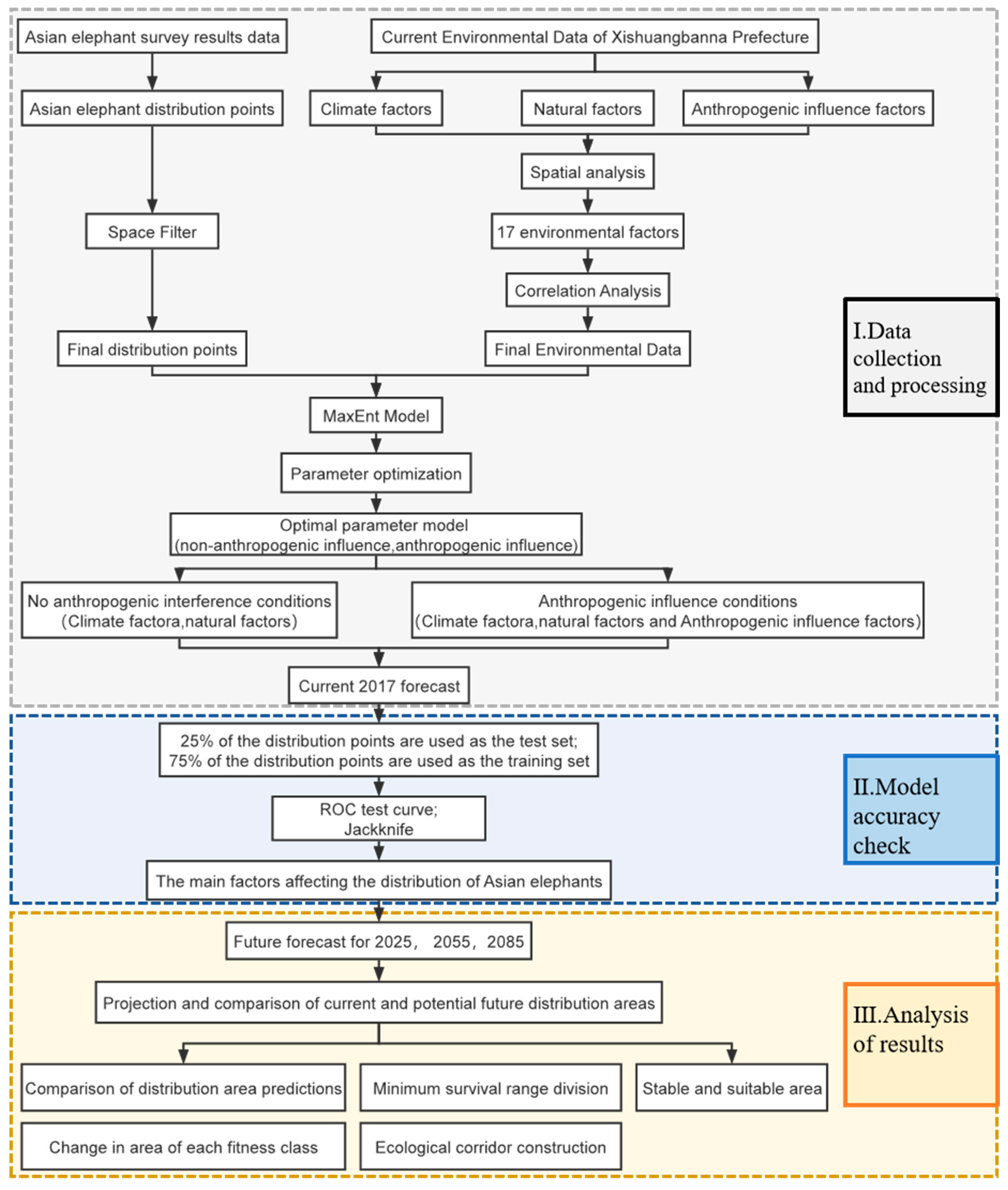
2. Materials and Methods

This study was divided into three parts, which were data collection and processing, model accuracy check, and analysis of results, as shown in Figure 1.

2.1. Study Area

Sipsongpanna Prefecture (21°09′–22°36′N, 99°58′–101°50′E) has the largest number of Asian elephants in China. It is located in the southernmost part of Yunnan Province, China, and its capital is Jinghong city [35]. It is located on the northern edge of the tropics south of the Tropic of Cancer, covers an area of 19,124.5 km2, and has a population of 1,301,407. It borders Pu’er city in the northeast and northwest, Laos in the southeast, and Myanmar in the southwest. The elevation range is 474–2429 m, and the region has a tropical monsoon climate [37]. Sipsongpanna has one county-level city (Jinghong City) and two counties (Mengla County and Menghai County). It has the largest tropical forest area in China, with a wide variety of flora and fauna. The Sipsongpanna Nature Reserve was established in 1958 to protect the local flora and fauna. It is the largest national nature reserve in China to protect tropical forests and covers five areas: Mengyang, Mengla, Shangyong, Mangyang, and Menglun. Asian elephants are currently found in the Mengla, Shangyong, and Mengyang subregions of the Sipsongpanna National Nature Reserve and surrounding areas [38].

2.2. Data Collection

The data in this study included Asian elephant distributions, environmental data affecting the distribution of Asian elephants, and administrative division data.

2.2.1. Asian Elephant Distribution Data

The Asian elephant distribution data in Sipsongpanna were obtained from a local survey of wild Asian elephants in Yunnan, China, conducted from January to June 2018 and combined with past surveys. The survey obtained the migration trajectories of Asian elephants in Sipsongpanna from 2013 to 2017 (Figure 2). This survey utilized the management experience of grassroots managers, applied remote sensing integration technologies, such as UAVs, an infrared camera, and GPS, and consisted of interviews, a counting and tracking survey, and a comprehensive assessment of the background of wild Asian elephant resources in Yunnan, China. The migration of Asian elephants occurs in March, and the migration time is very short. The Asian elephant distribution data were preprocessed as follows. The Asian elephant migration trajectories from 2013 to 2017 were combined. The sdmtoolbox tool (http://www.sdmtoolbox.org/, accessed on 22 January 2023) was used to eliminate redundant sample data with a threshold of 5 km to ensure that each raster cell had only one sample point to avoid overfitting, reduce the sampling bias caused by the cluster effect, and improve the simulation [39,40]. Ultimately, 101 valid distribution points were retained.

2.2.2. Environmental Data Affecting the Distribution of Asian Elephants

We selected environmental factors affecting the habitat of Asian elephants by conducting a literature review and examining the environmental characteristics of Sipsongpanna. The environmental data included climate, natural, and anthropogenic influence factors. The main changes in the Sipsongpanna region in recent years have been in population numbers and climate, and the region has seen no significant changes in cropland and construction land due to the high priority given to ecological control. Therefore, we do not consider land use changes in the model. The remote sensing data and products used in this study are described in detail in Appendix A.
(1) Climate factors. Six annual climate variables were selected for the current scenario (2017) and the two climate scenarios in the future (2025, 2055, and 2085), including the mean annual temperature (MAT) [8], mean annual precipitation (MAP) [41], and mean warmest month temperature (MWMT) [42]. In the RCP8.5 scenario (high emissions), the CO2 concentration in the air is 3–4 times higher in 2100 than at pre-industrial levels. In the RCP4.5 scenario (medium-low emissions), the level of anthropogenic carbon emissions decreases after 2080 but still exceeds the allowed value [27].
(2) Natural factors included slope [43], aspect [43], altitude (Alt) [43], distance to water resource (Dis_river) [44], normalized difference vegetation index (NDVI) [44], and vegetation cover type (VCT) [44]. The underlying data for VCT was obtained from the Google Earth Engine (GEE) platform. We downloaded Landsat 8 OLI images with less than 5% cloud acquired in February 2017 and preprocessed them. The images were mosaicked to obtain an image of the study area. We obtained land cover data and selected training and test samples for the vegetation change map of the Asian elephant range. The random forest model was used for the classification, and we performed validation of the results. The overall accuracy was >85%. We used nine categories of VCT: broadleaf forest, tropical rainforest, shrubland, water, coniferous forest, bare ground, cropland, grassland, and impervious surface. The details are shown in Figure 3.
(3) Anthropogenic influence factors included population density (PD) [34], nighttime lights (NL) [34], distance to roads (Dis_road) [45], and distance to residential areas (Dis_res) [45]. We performed projections of future population density. The impervious surface land cover type was extracted, and the rural and township areas were divided by the ground survey and tenure data. The population data at the township level were obtained from the 2017 statistical yearbook released by the Sipsongpanna Bureau of Statistics. The data were spatially matched to the rural and township layers to obtain the 2017 PD data of Sipsongpanna. The data were validated by comparing them with Landscan and Worldpop data from the same period. Population size projections were conducted according to China’s 14th Five-Year Plan and Territorial Spatial Planning. The future PD data were obtained by projecting the population at future growth rates using the World Population Prospects 2022 (https.//population.un.org/wpp, accessed on 22 November 2022) published by the United Nations Department of Economic and Social Affairs.
These data sources and their biological significance are summarized in Table 1. The environmental data of the 16 Sipsongpanna regions were unified in terms of image size, range, and spatial reference and converted to *. ASCII format for input into the MaxEnt 3.4.1 model (Figure 3). We obtained a unified and integrated species conservation dataset covering the study area (Table 1).

2.2.3. Administrative Division Data

Administrative division data were produced based on the standard map with the review number GS (2019) 1822 downloaded from the standard map service website of the National Bureau of Surveying, Mapping and Geographic Information for Menghai County, Jinghong City, and Mengla County in Sipsongpanna Prefecture.

2.3. Data Processing and Parameter Optimization

2.3.1. Optimization of Distribution Data, Correlation Analysis, and Screening of Environmental Variables

The distribution data were screened to remove duplicate entries based on the spatial resolution of the environmental data to ensure that only one data point was located in each raster cell [39,40]. Thus, model overfitting was minimized to improve the prediction quality. After screening, 101 data points were retained (Figure 2) and converted to a format readable by the MaxEnt software. All environmental variables were fed into the MaxEnt model, which was run ten times to obtain the contribution rate of each environmental variable, eliminating those with low contribution rates and retaining only those with contribution rates greater than 1% [46,47]. Spearman correlation analysis was performed on all environmental variables. If the absolute value of the correlation coefficient between two environmental variables was greater than 0.8, a significant correlation existed between the two variables, and the environmental variable with less influence on the species distribution was excluded [48,49]. Finally, we selected nine ecological variables to predict the suitable distribution areas for Asian elephants in Sipsongpanna, including climate factors (MWMT, MAP, and TD), natural factors (Alt, Aspect, and Dis_river), and anthropogenic influence factors (PD, Dis_road, and Dis_res). Although we selected several strongly influential variables, but this does not mean that the excluded environmental variables were irrelevant. The reason may be attributed to multicollinearity, which causes the model to exclude relevant variables. However, the retained environmental variables were highly representative.

2.3.2. Analysis and Optimization of Habitat Area Variables Using the MaxEnt Model

The MaxEnt principle assumes that the probability model must satisfy certain constraints. Without more information, the uncertain parts are equiprobable [50]. The MaxEnt principle expresses the equiprobability by maximizing the entropy. Equiprobability is not easy to manipulate, whereas entropy is a numerical indicator that can be optimized. This method uses the actual species distribution and the environment (bioclimatic and abioclimatic factors) to fit the probability distribution with the MaxEnt value. It constructs a constraint with high confidence and establishes a correlation between the environmental elements and the species distribution to simulate and predict the species’ potential habitat [51].
These operations are implemented in the MaxEnt software. The two most essential parameters of MaxEnt are the feature combination (FC) and regularization multiplier (RM). Optimizing these parameters significantly improves the model’s prediction accuracy [46,52,53]. The MaxEnt model can predict species distribution better with a small sample size. However, the prediction of potential distributions is prone to overfitting, limiting the transferability of the model to another species. Many studies have created a new MaxEnt model after the optimization by setting the FC and RM in the training process. A model with optimized parameters has a better fit and less complexity than a model with the default parameters, demonstrating the importance of parameter optimization. We used the Kuenm package and ran the MaxEnt prediction for 1240 models with different parameter combinations (31 FC settings with 40 combinations of RM values) [52,54,55]. Statistically significant (significant models) models with omission rates of less than 5% were selected. Then the models with less than two delta Akaike information criterion (AICc) values were chosen [52,56]. Finally, the combination with the smallest delta AICc value is used as the optimal parameter.

2.3.3. Delineation and Model Assessment of Current and Future Potentially Suitable Areas for Asian Elephants

The jackknife method is a highly reliable cross-validation technique for assessing the bias and variance of models. We used it to analyze the contribution and variable importance of the environmental variables regarding species distribution. It was applied in the MaxEnt software by subtracting one environmental sequentially and performing modeling with the remaining environmental variables. The results are shown in Figure 4. The regularized training gain and test gain are the training and test sets of the area under the curve (AUC), respectively. We derived the most important environmental factors based on the contribution of the environmental variables and the importance value [57]. Ten-fold cross-validation was performed, and the average was used as the prediction result. The result of the MaxEnt model is the probability of species occurrence, with values ranging from 0 to 1. We chose the maximum sum of sensitivity and specificity (Max SSS) to determine the threshold to distinguish suitable and unsuitable areas and binarized the average suitability (i.e., occurrence probability) of the raster maps to classify the habitat into non-suitable and suitable areas [55,58]. The suitable areas were classified into areas of low, medium, and high suitability, according to the site monitoring results. In addition, we considered the minimum range and the habitat required to sustain the Asian elephant in the region. These areas should become priority areas for conservation [42,59]. Studies have shown that the minimum area needed to maintain an Asian elephant home range is 105 km2 [59,60]. Since there are four Asian elephant home ranges in Sipsongpanna, we used a minimum area of 420 km2 [61] to determine the areas that should be protected. The receiver operating characteristic (ROC) curve was used to evaluate the model’s prediction accuracy, and the AUC value was used as the evaluation index. The AUC evaluation criteria were 0.50–0.60 for invalid prediction, 0.60–0.70 for poor prediction, 0.70–0.80 for fair prediction, 0.80–0.90 for good prediction, and 0.90–1.00 for excellent prediction [62].

2.4. Habitat Connectivity Analysis

Circuit theory was used to quantify the potential movement paths of Asian elephants under current and future climate scenarios. The circuit theory model is based on the random walk theory and treats the landscape as a resistance surface, where habitat patches, populations, or reserves represent source and target cells and are assigned zero resistance [63]. The magnitude of the currents represents the probability of species dispersal on a given path [64,65]. High-density currents represent significant movement between two patches. This strategy can be used to predict random movements of walkers between source and target areas [65]. In this model, elephants are used as random walkers. A negative exponential conversion function is used to convert the habitat suitability index (described in Section 2.3.3) to resistance values. Current and future suitable habitats are used as focal nodes, and the pairwise connectivity between all pairs of focal nodes is calculated [42,66].

3. Results

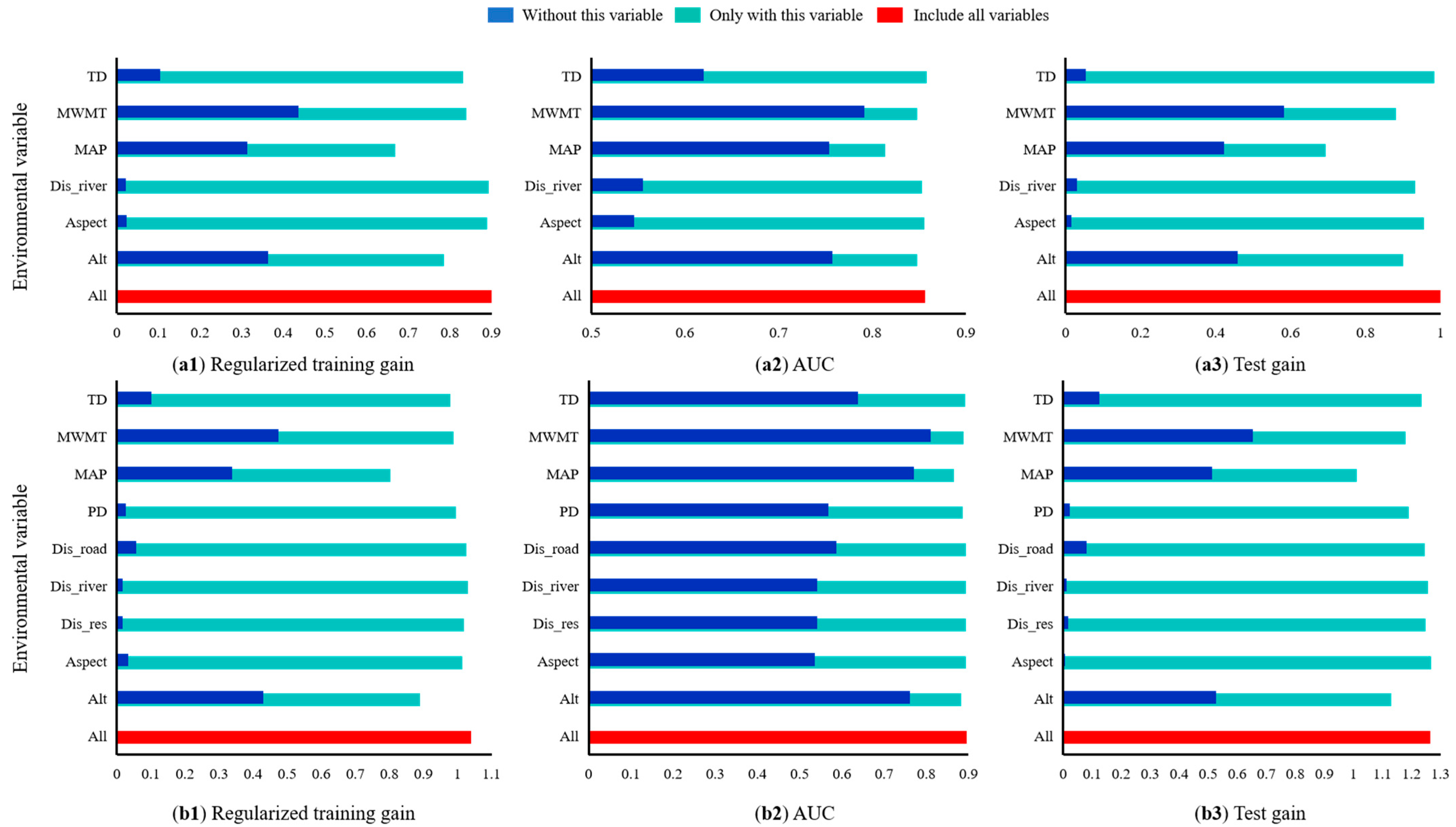
3.1. Dominant Variables Affecting the Distribution of Asian Elephants in Sipsongpanna

All 1240 models were statistically significant under NAI. We selected six models; model 1 had the smallest delta AICc value (equal to 0). This result indicated that this model best represented the actual species distribution [56]. No overfitting occurred, and the model had the optimum FC of the quadratic features (Q), product features (P), and threshold features (T). The value of the RM was 1.6. Similarly, all 1240 models were statistically significant for the simulations with AI. We selected three models. Model 1 had the smallest delta AICc value (equal to 0), indicating it was the optimal model. The features included linear features (L), Q, and T, and the RM value was 2.1 [56].
The parameter-optimized MaxEnt model was used with ten replications to simulate the suitable area for Asian elephants in Sipsongpanna under current climate conditions and NAI. The maximum value of the training AUC was 0.909, the minimum value was 0.871, and the average value was 0.889. The results indicated that the model had high prediction accuracy and stability. The proportions of high, medium, and low suitability areas for the 101 Asian elephant distribution sites were 74.58%, 23.98%, and 1.44%, respectively. Similarly, the same model was used for the simulation under AI. The parameter-optimized MaxEnt model was used to simulate the suitable area for Asian elephants in Sipsongpanna under the current climate model with 10 repetitions under AI conditions. The maximum value of the training AUC was 0.923, the minimum value was 0.901, and the average value was 0.913. The results indicated that the model had excellent prediction accuracy and high stability. The proportions of high, medium, and low suitability areas were 75.91%, 23.44%, and 0.65%, respectively. Since the MaxEnt model showed high accuracy, it was used to predict the potential distribution of Asian elephants in Sipsongpanna.
Two methods are usually used to evaluate the contribution of environmental factors to the MaxEnt model. The first is the percentage contribution and variable importance. We analyzed the contribution of six environmental variables to the distribution of Asian elephants in Sipsongpanna under NAI with the MaxEnt model. The results showed that the environmental variables Alt, MAP, and MWMT were the dominant factors affecting the distribution of Asian elephants in Sipsongpanna, with contributions of 37.1%, 25.5%, and 22.4%, respectively. The cumulative contribution rate of the three variables was 85%. Under AI, the same dominant factors affected the distribution of Asian elephants in Sipsongpanna, with cumulative contribution rates of 44.5%, 23.7%, and 14.9%, respectively. The contribution of AI factors was relatively small, with a cumulative contribution of only 10.3% (Table 2).
Second, we used the jackknife method to analyze the influence of the environmental variables on the Asian elephant distribution results. Under NAI, the MWMT and Alt had the largest contribution, with training gains of 0.44 and 0.35, respectively. MAP was a secondary factor affecting the distribution of Asian elephants in Sipsongpanna, with a training gain of 0.32. The least influential factors were Aspect and Dis_river, with training gains of 0.1, consistent with the results of the contribution rate analysis [47] (Figure 4a1–a3). Under AI, the MWMT and Alt were the most influential factors, with training gains of 0.45 and 0.43, respectively. MAP was a secondary factor affecting the distribution of Asian elephants in Sipsongpanna, with a training gain of 0.33. The least influential factors were TD, PD, and Aspect, with training gains of 0.2. These findings are consistent with the results of the contribution analysis (Figure 4b1–b3), indicating that the selected environmental variables are sufficiently effective to fit the current distribution of Asian elephants in Sipsongpanna [47].

3.2. Response Analysis of the Main Environmental Variables Affecting the Distribution of Asian Elephants

There was a strong relationship between the distribution of Asian elephants in Sipsongpanna and the dominant environmental variables. Figure 5 shows the feedback curve between the dominant environmental variables and the distribution probability obtained from the MaxEnt model, reflecting the range of values of the environmental variables for different thresholds. The maximum sum of the specificity and sensitivity of the training data was 0.29, which was used as the threshold to classify the habitat into non-suitable and suitable zones. The suitable habitat was divided into areas of low suitability (0.29–0.42), medium suitability (0.42–0.58), and high suitability (>0.58) [67]. The optimum ranges of Alt, MWMT, and MAP were, respectively, 669.84–1011.64 m, 1600.77–1747.59 mm, and 24.67–25.64 °C under NAI (Figure 5a1–a3) and 694.45–985.66 m, 1664.57–1741.86 mm, and 24.58–25.67 °C under AI (Figure 5b1–b3).

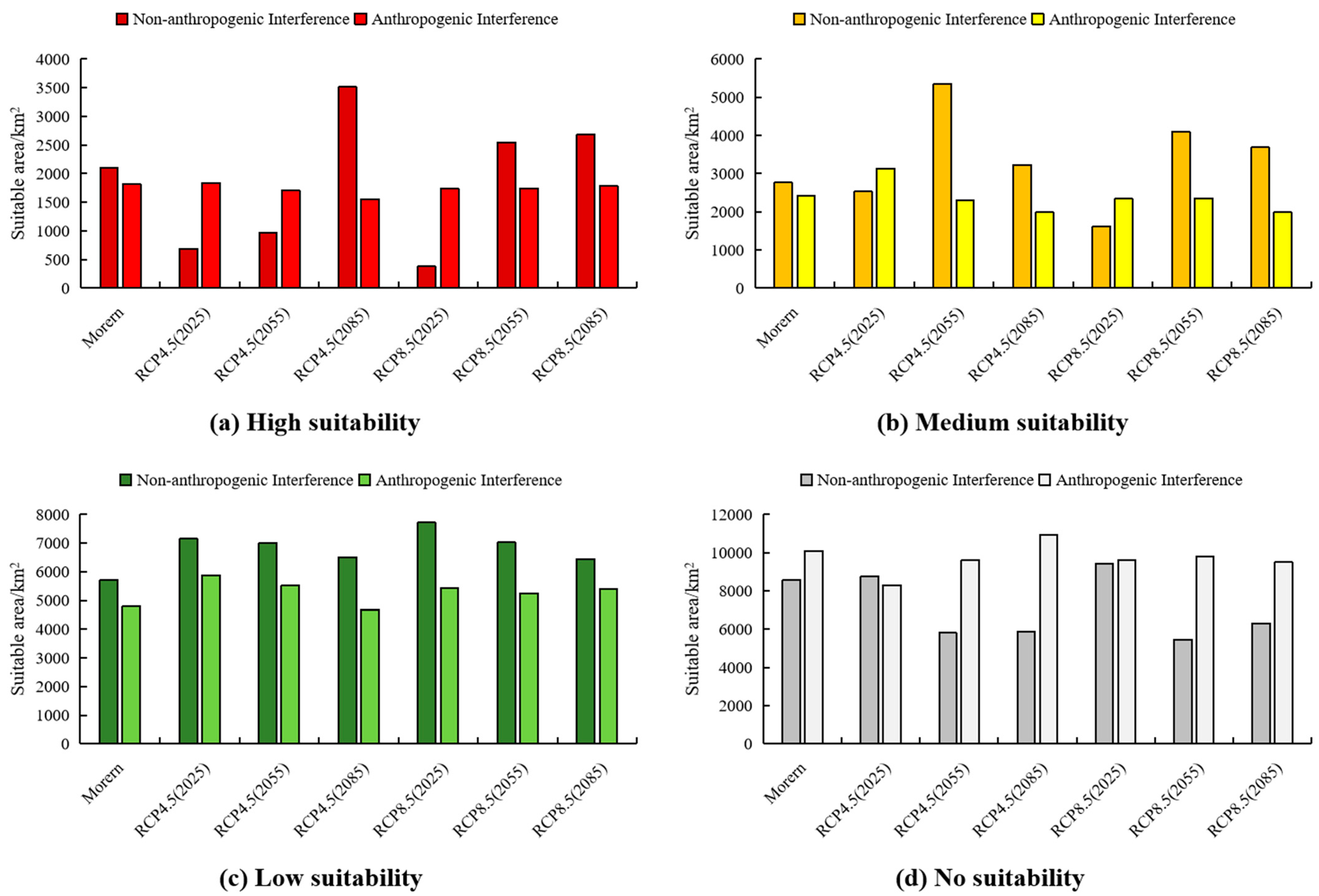
3.3. Prediction of Suitable Areas for Asian Elephants in Sipsongpanna under Current Climatic Conditions

The optimized MaxEnt model was used to predict suitable areas for Asian elephants under current climate conditions and for NAI and AI. The results are depicted in Figure 6. Under NAI, potentially suitable areas for Asian elephants in Sipsongpanna covered 9342.86 km2, accounting for 51.23% of the state area. Areas with low, medium, and high suitability were 4711.43 km2, 2456.77 km2, and 1998.75 km2, with proportions of 25.34%, 11.82%, and 11.61% of the total area, respectively. Under AI, potentially suitable areas for Asian elephants covered 9023.41 km2, accounting for 46.35% of the state area. Areas with low, medium, and high suitability were 4796.32 km2, 2437.83 km2, and 1804.56 km2, accounting for 25.64%, 13.23%, and 14.78%, respectively, of the total area. The total potentially suitable area for Asian elephants was 282.54 km2 smaller (2.94% lower) for AI than for NAI, and the decrease in the area occurred primarily in areas of high suitability. Under current climate conditions, areas with high suitability were primarily located in the central part of Jinghong city and the southern part of Mengla county, Sipsongpanna. Areas with medium suitability were located primarily in the central part of Jinghong city and Mengla county, Sipsongpanna. Areas with low suitability were located in the southern part of Jinghong city and the western part of Mengla county, Sipsongpanna.

3.4. Potentially Suitable Areas for Asian Elephants in Sipsongpanna under Different Future Climate Scenarios

Figure 7a1–a6 show potentially suitable areas for Asian elephants in Sipsongpanna under two climate scenarios (RCP45 and RCP85) in 2025, 2055, and 2085 under NAI. The largest reduction in the suitable area compared to current conditions occurred for the 2025-RCP85 climate scenario (825.66 km2, representing a 7.93% reduction). The remaining scenarios showed an increasing trend in the suitable area. The 2055-RCP85 climate scenario exhibited the largest increase (3064.25 km2, representing an increase of 28.65%). The 2025-RCP85 climate scenario showed the largest decrease in areas of high suitability (81.68% decrease), and the 2085-RCP45 climate scenario exhibited the largest increase in areas of high suitability (66.54% increase). Areas of medium suitability areas decreased the most under the 2025-RCP85 climate scenario (42.55% decrease) and increased the most under the 2055-RCP45 climate scenario (93.36% increase). Areas of low suitability increased in all scenarios, with the largest increase of 36.07% in the 2025-RCP85 climate scenario. Areas of non-suitability decreased in most scenarios, except for 2025-RCP45 and 2025-RCP85, with the largest decrease of 36.43% in the 2055-RCP85 climate scenario (Figure 8).
Figure 7b1–b6 show potentially suitable areas for Asian elephants in Sipsongpanna under two climate scenarios (RCP45 and RCP85) in 2025, 2055, and 2085 under AI. The suitable areas tended to decrease under most scenarios except for an increase under the 2025-RCP4.5 scenario. The suitable area decreased the least under the 2085-RCP8.5 scenario (455.41 km2, representing a 4.55% decrease). The largest decrease occurred under the 2085-RCP4.5 scenario (1877.96 km2, 18.56% decrease). Areas with high suitability showed a decrease, with the largest decrease of 16.37% under the 2085-RCP45 climate scenario. Areas of medium suitability areas generally decreased, except for an increase of 28.94% in the 2025-RCP45 climate scenario. The largest decrease of 19.58% was observed in the 2085-RCP45 climate scenario. Areas with low suitability generally increased, except for 2085-RCP45, and the largest increase of 23.05% occurred in the 2025-RCP45 climate scenario. Areas of no suitability generally decreased, except for 2085-RCP45, with the largest decrease of 18.14% in the 2025-RCP45 climate scenario (Figure 8).
Areas meeting the future minimum habitat range of Asian elephants are located in Mengman Town, Mohan Town, Guanlei Town, Mengban Town, Yao District Township, Yiwu Town, Dadugang Township, and Mengwang Township. The townships that should be protected are Mengman Town, Mohan Town, Mengla Town, Mengban Township, Dadugang Township, and Mengwang Township (Figure 6 and Figure 7).

3.5. Potential Migration Corridors of Asian Elephants

Under current and future climatic conditions, the migration corridors of Asian elephants are located in Jinuoshan Township, Menghan Township, Guanlei Township, Menglun Township, Yaoqu Township, Yiwu Township, Xiangming Township, and Mengban Township (Figure 6 and Figure 7).

4. Discussion

4.1. The Importance of Constructing a Basic Dataset for Species Conservation Using Multisource Remote Sensing Data

Traditional species conservation datasets typically focus on one dimension, such as only considering the climate influence on habitat suitability [9,21,62], on a single scale, such as only relying on one scale of remote sensing data [68], or lacking multisource heterogeneous remote sensing datasets, failing to integrate the air-sky-ground dimensions [69]. The rapid development of remote sensing data and products has provided rich data sources for large-scale habitat research [10,11,12]. Our study of Asian elephant distribution utilized multisource data obtained by advanced technologies such as UAVs, infrared cameras, and GPS to improve accuracy and reduce the amount of fieldwork. The high spatial resolution and accuracy and open-source remote sensing data products enable the quantification of habitat suitability evaluation factors. We utilized these remote sensing data and a product-driven system to evaluate Asian elephant habitat suitability in Sipsongpanna. Land use/land cover remote sensing data were used to represent the habitat preferences of Asian elephants [44], providing more accurate data to support the habitat suitability evaluation of Asian elephants in Sipsongpanna [10]. Advances in remote sensing mapping technology for land use/land cover have provided global-scale land use/land cover products. In addition, habitat monitoring based on multi-source remote sensing data and products is superior to using traditional data sources. It improves the efficiency of large-scale habitat suitability research and has great potential for responding to wildlife emergencies [10]. In this emergency response to the northern migration of Asian elephants, the relevant departments relied primarily on UAV remote sensing data to monitor the dynamic changes of the elephant herd because the high spatial resolution and near real-time satellite data were not sufficient to monitor the movement of the Asian elephants [70]. In the future, remote sensing fusion and other technologies can be integrated to take advantage of multisource remote sensing data and improve the accuracy of the dataset, and the habitat suitability evaluation of Asian elephants [71].

4.2. Prediction of Suitable Habitat for Asian Elephants in Sipsongpanna under Current Conditions Based on the Optimized MaxEnt + ClimateAP Model

We used the Kuenm package for model parameter optimization, performed multiple parameter comparisons, and systematically optimized a complex model, which was superior to traditional models [52]. The optimized model had the smallest delta AICc value (equal to 0), was statistically significant, and had an omission rate of less than 5%. The training AUC >0.9 indicated that the model’s performance and prediction accuracy were higher than those of the model with the default parameters. The model accurately predicted the distribution of Asian elephants in Sipsongpanna using various environmental variables [53]. A comparison of the actual and predicted Asian elephant distribution showed that the MaxEnt model predicted the potential distribution of Asian elephants in Sipsongpanna with high accuracy under AI. The current potential habitat range was larger than the actual one under NAI and AI, and no Asian elephants were predicted in Menglong town. The likely reason might be that environmental factors, such as interspecific relationships, food availability, and vegetation type, affected the species distribution at different spatial and temporal scales [72]. The prediction results of the MaxEnt model under AI showed that MWMT, MAP, Alt, TD, PD, Aspect, Dis_road, Dis_river, and Dis_res were the dominant environmental variables affecting the potential distribution of Asian elephants in Sipsongpanna. The variable contribution and the jackknife test showed that the top three environmental variables influencing the potential distribution of Asian elephants in Sipsongpanna were Alt, MAP, and MWMT, similar to the findings of another study on the distribution of Asian elephants in China [42]. Relevant research results have shown that the cold-season precipitation, altitude, seasonal standard deviation of temperature, warmest seasonal precipitation, slope, and monthly mean diurnal temperature difference were the main factors influencing the distribution of Asian elephants in China [5]. The standard deviation of the seasonal temperature was the most important variable, followed by the monthly mean of the diurnal temperature difference and the mean temperature of the driest quarter. Asian elephants prefer areas at lower elevations and on gentler slopes because travel is physically demanding for the largest land herbivore [73]. Temperature, precipitation, and topography were the main primary factors affecting the distribution of Asian elephants in another study [74]. The majority of Asian elephant habitat in the study area is located along the mainstreams of rivers, indicating the significant influence of topography in agreement with the results of many studies [41,42,75]. In summary, using an optimized model and considering climate effects enabled us to predict the distribution of Asian elephants in Sipsongpanna accurately under current conditions.

4.3. Prediction of Suitable Habitat for Asian Elephants in Sipsongpanna under Future Conditions

We simulated the distribution of Asian elephants in suitable areas in Sipsongpanna using the optimized model coupled with a climate model and incorporating future population projections. Studies in recent decades have shown that the range of Asian elephants in southwestern Yunnan has decreased, and they are highly dispersed. The main reason is human impacts, such as overexploitation [31]. Climate change may exacerbate HEC [76]. In addition, the expansion of settlements and agricultural land has led to the widespread loss of elephant habitat, degradation of forage, reduced landscape connectivity, and a significant decline in elephant populations and range [8]. We used high spatial resolution population density data to simulate the changes in Asian elephant habitats under future climate change conditions. Under NAI, the area of the suitable zone generally increased for most climate scenarios, except for decreases in the suitable areas in the 2025-RCP45 and 2025-RCP85 climate scenarios. Under AI, the suitable area decreased in all scenarios, except for an increase under the 2025-RCP4.5 climate scenario. Although the total suitable area showed an increasing trend under AI, most of the increase occurred in areas of low suitability, whereas areas of medium and high suitability decreased. After AI occurred, the potential distribution area declined. The likely reason is that AI, such as roads, settlements, and farmland, adversely affected the distribution of Asian elephants [31]. If the suitable habitat decreases, the Asian elephants may not be able to survive in the future, and HEC will increase unless conservation measures are implemented [38,77,78,79]. We identified habitat areas less vulnerable to climate impacts and prioritized them for conservation [34,35]. In addition, the evaluation of future suitable habitats indicates that it is necessary to prioritize the protection of areas with the minimum habitat range in the protected areas.
Climate change is expected to alter the potential movement and distribution of Asian elephants. Therefore, conservation strategies must incorporate ecological and anthropogenic impacts into the design, location, and management of protected areas in addition to considering climate change [41]. Therefore, we predicted the distribution of suitable habitats for Asian elephants under current and future climatic conditions. It is necessary to prioritize the protection of areas with the minimum habitat range. We also delineated migration corridors between different protected areas. Selecting suitable areas to establish corridors between isolated habitats is necessary to prevent the isolation of Asian elephant populations [41]. Corridors increase the connectivity between habitats and reduce human-elephant conflict [8]. The results suggest that ecological corridors should be established in Maban, Yaoqu, Guanlei, Yiwu, Xiangming, and Jinniushan towns to ensure the connectivity between nature reserves and facilitate the migration of Asian elephants. These habitats are mainly located in low-elevation forest areas and along the mainstreams of rivers. They are far from human activities and have suitable temperatures. These habitats meet the requirements of Asian elephants, and the results are similar to previous studies [31,59]. The establishment of ecological corridors is a long-term and ambitious project requiring large investments. It may face difficulties, but the success of the project will ensure the long-term survival of the local Asian elephant population and have a profound impact on the harmonious coexistence between humans and elephants [38,75,80,81,82]. In short, a scientific understanding of the effects of climate change and natural and anthropogenic influences on species distribution and migration is required for conserving biodiversity and planning nature reserves.

5. Conclusions

We examined the effects of ecological factors related to climate and natural and anthropogenic influences on the distribution of Asian elephants in Sipsongpanna under current and future climate conditions and with and with anthropogenic influences. We used multisource remote sensing data and products, multiyear elephant field tracking data, a MaxEnt species distribution model, and a climate model. We first predicted the distribution under current (2017) conditions. The result was validated using the existing Asian elephant migration trajectories. Subsequently, potentially suitable areas for Asian elephants in Sipsongpanna were obtained under two climate change scenarios (RCP4.5, RCP8.5) in three future periods (2025, 2055, and 2085). The changes in potentially suitable areas for Asian elephants under multiple climate change scenarios for the current and future periods were analyzed by considering the effects of human activities. The results showed that the optimal FC of the MaxEnt model was LQT, and the RM = was 2.1 under AI. The optimized MaxEnt model had a high prediction accuracy with AUC = 0.913. In addition, the jackknife analysis showed that Alt, MWMT, and MAP were the top three factors affecting the distribution of Asian elephants under AI, with the ranges of 694.45–985.66 m, 24.58–25.67 °C), and 1664.57–1741.86 mm, respectively. Moreover, the proportion of the suitable area for Asian elephants in Sipsongpanna under current climate conditions and AI was 46.35% of the total area. Highly suitable areas were located in Jinghong City in central Sipsongpanna and Mengla County in southeastern Sipsongpanna. The suitable area for Asian elephants generally showed a decreasing trend from 2017 to the future periods under two climate change scenarios, except for the 2025-RCP4.5 climate scenario. The suitable area decreased the least under the 2085-RCP8.5 climate scenario (455.41 km2; 4.55% decrease). The largest decrease occurred under the 2085-RCP4.5 scenario (1877.96 km2; 18.56% decrease).
Our results can be used to formulate future conservation policies in suitable areas for Asian elephants. We considered the PD in the future under different climate change scenarios. We developed a model to evaluate habitat suitability and simulated the potential distribution, minimum habitat range, and ecological corridors of Asian elephants in the state of Sipsongpanna under current and future climate conditions. Our quantitative data can be used to help Asian elephants adapt to climate change and mitigate HEC in the future. In subsequent studies, we plan to combine long time-series remote sensing data to investigate the spatial and temporal processes and driving mechanisms of suitable habitats for Asian elephants to provide scientific support for habitat conservation and the creation of nature reserves for Asian elephants in China [45].

Author Contributions

K.H. wrote the original manuscript; K.H. and C.F. performed the experiments; K.H. and C.F. analyzed the data; L.C. Conceptualization and Supervision; M.Z., F.C. and G.W. Resources; K.H., C.F., M.Z. and L.C. edited the manuscript. All authors have read and agreed to the published version of the manuscript.

Funding

This research was funded by the National Natural Science Foundation of China (31922055) and the Priority Academic Program Development of Jiangsu Higher Education Institutions (PAPD).

Data Availability Statement

Not applicable.

Acknowledgments

We would like to thank Xin Shen and the graduate students from the department of forest management at Nanjing Forestry University for providing suggestions for improving this study.

Conflicts of Interest

The authors declare no conflict of interest.

Appendix A

Table A1. Summary of remote sensing data and products used in this study.
Name of Remote Sensing DataTimeSpatial
Resolution and Accuracy
SourceDescription
ClimateAP201720252055208530 m/99%Available online: https://climateap.net/
(accessed on 28 December 2021)
Coupling several climate models and land surface process models with satellite remote sensing data to simulate surface climate environment changes.
ASTER GDEM v3201930 mAvailable online: http://www.gscloud.cn/search
(accessed on 22 February 2022)
ASTER GDEM data products are derived from the Advanced Spaceborne Thermal Emission and Reflection Radiometer (ASTER) and are the only high-resolution global elevation data currently available.
Land Cover Type201730 m/71%Available online: http://data.ess.tsinghua.edu.cn/
(accessed on 25 February 2022)
Classification based on remote sensing satellite images.
Landsat8 OLI 201730 mAvailable online: http://www.gscloud.cn/search
(accessed on 23 February 2022)
Landsat 8 is the eighth satellite of the U.S. Landsat program (Landsat).
Roads2019 Available online: https://lbs.amap.com/
(accessed on 2 March 2022)
The Gaode Map JS API is a programming interface for map applications developed in JavaScript. It is suitable for mobile applications and PCs.
Rivers2019 Available online: https://lbs.amap.com/
(accessed on 2 March 2022)
The Gaode Map JS API is a programming interface for map applications developed in JavaScript. It is suitable for mobile applications and PCs.
Residential Locations2019 Available online: https://www.openstreetmap.org/
(accessed on 4 March 2022)
OpenStreetMap is an open-source map based on satellite imagery. The data are updated daily and can be edited.
Night Lights2017500 m/69%Available online: https://www.ngdc.noaa.gov/eog/viirs/download_dnb_composites.html
(accessed on 6 March 2022)
This dataset was derived from the Visible Infrared Imaging Radiometer Suite (VIIRS) that obtains nighttime imagery (Day/Night Band, DNB band).
Landscan20171000 m/75%Available online: https://landscan.ornl.gov/
(accessed on 6 March 2022)
An innovative approach that combines Geographic Information System (GIS) and Remote Sensing (RS) imagery.
Worldpop20171000 m/66%Available online: https://www.worldpop.org/project/categories?id=3
(accessed on 6 March 2022)
Open high-resolution geospatial datasets on population distribution, demographics, and dynamics derived from remote sensing imagery and geoinformation technology.
Social Media Tweet Density2017 Available online: http://open.weibo.com/wiki/SDK
(accessed on 8 March 2022)
Weibo Open Platform provides a convenient cooperation model for mobile applications, meeting the needs of diversified mobile terminal users to quickly log in and share information anytime and anywhere. It provides social access to multiple types of terminals, such as mobile Apps, health devices, smart homes, and vehicles.

References

  1. IPCC. Climate Change 2013—The Physical Science Basis; Cambridge University Press: Cambridge, UK, 2014. [Google Scholar]
  2. Lister, A.M.; Stuart, A.J. The impact of climate change on large mammal distribution and extinction: Evidence from the last glacial/interglacial transition. C. R. Geosci. 2008, 340, 615–620. [Google Scholar] [CrossRef]
  3. Ye, S.; Fang, Y.; Li, K. Impact of urbanization on insect diversity. Biodiversity 2013, 21, 260–268. [Google Scholar] [CrossRef]
  4. Schloss, C.A.; Nunez, T.A.; Lawler, J.J. Dispersal will limit ability of mammals to track climate change in the Western Hemisphere. Proc. Natl. Acad. Sci. USA 2012, 109, 8606–8611. [Google Scholar] [CrossRef]
  5. Jiang, Z. Maximum Entropy Model (MaxEnt) Prediction of Suitable Habitat for Wild Asian Elephants in China in a Climatic Context. Master’s Thesis, Yunnan University, Kunming, China, 2019; p. 97. [Google Scholar]
  6. Levinsky, I.; Skov, F.; Svenning, J.; Rahbek, C. Potential impacts of climate change on the distributions and diversity patterns of European mammals. Biodivers. Conserv. 2007, 16, 3803–3816. [Google Scholar] [CrossRef]
  7. Paula, A.; Pedro, A.; Josefa, V.; David, T.B.; Andrés, M.; David, S.F. Evaluating drivers of vulnerability to climate change: A guide for insect conservation strategies. Glob. Chang. Biol. 2012, 18, 2135–2146. [Google Scholar] [CrossRef]
  8. Wenwen, L.; Peng, L.; Xianming, G.; Lanxin, W.; Qiaoyan, W.; Yang, Y.; Yunchuan, D.; Li, L.; Li, Z. Human-elephant conflict in Xishuangbanna Prefecture, China: Distribution, diffusion, and mitigation. Glob. Ecol. Conserv. 2018, 16, e00462. [Google Scholar] [CrossRef]
  9. Wu, J.; Lv, J. Potential impacts of climate change on the distribution of giant pandas. Sci. Technol. 2009, 32, 168–177. [Google Scholar] [CrossRef]
  10. Grekousis, G.; Mountrakis, G.; Kavouras, M. An overview of 21 global and 43 regional land-cover mapping products. Int. J. Remote Sens. 2015, 36, 5309–5335. [Google Scholar] [CrossRef]
  11. Zacarias, D.; Loyola, R. Distribution modelling and multi-scale landscape connectivity highlight important areas for the conservation of savannah elephants. Biol. Conserv. 2018, 224, 1–8. [Google Scholar] [CrossRef]
  12. Jun, C.; Ban, Y.F.; Li, S.N. Open access to Earth land-cover map. Nature 2014, 514, 434. [Google Scholar] [CrossRef] [Green Version]
  13. Mehler, K.; Burlakova, L.E.; Karatayev, A.Y.; Biesinger, Z.; Bruestle, E.; Valle-Levinson, A.; Castiglione, C.; Gorsky, D. Integrating remote sensing and species distribution modelling to predict benthic communities in a Great Lakes connecting channel. River Res. Appl. 2017, 33, 1336–1344. [Google Scholar] [CrossRef]
  14. Li, Y.; Han, B.; Wang, X. Resource one operational satellite development overview. Spacecr. Eng. 2020, 29, 1–9. [Google Scholar] [CrossRef]
  15. Wang, Q.; Zheng, S.; Feng, H.; Wang, Y.; Bai, Z.; Meng, B.; Chen, H. Construction of a national comprehensive monitoring technology system for urban ecological environment. J. Geo-Inf. Sci. 2020, 22, 1922–1934. [Google Scholar] [CrossRef]
  16. Wang, F.; Zheng, X.; Ma, J.; Wang, Z.; Liu, Y.; Yao, C.; Li, Z.; Chen, M. Application of UAV technology in the survey and monitoring of wild Asian elephants in China. For. Constr. 2019, 6, 38–44. [Google Scholar]
  17. Yan, L.; Liao, X.; Zhou, C.; Fan, B.; Gong, J.; Cui, P.; Zheng, Y.; Tan, X. An overview of China’s UAV remote sensing technology breakthrough and industrial development. J. Geo-Inf. Sci. 2019, 21, 476–495. [Google Scholar] [CrossRef]
  18. Stephenson, P.J. Integrating Remote Sensing into Wildlife Monitoring for Conservation. Environ. Conserv. 2019, 46, 181–183. [Google Scholar] [CrossRef]
  19. Yang, H. Habitat Analysis of Wild Camels in the Kumtag Desert Region and the Impact of Climate Change. Ph.D. Thesis, China Academy of Forestry Science, Beijing, China, 2011; p. 112. [Google Scholar] [CrossRef]
  20. He, Y. Simulation of Geographical Distribution and Analysis of Dominant Climatic Factors of Five Species of Piper spp. Master’s Thesis, Northwest A&F University, Yangling, China, 2015; p. 58. [Google Scholar] [CrossRef]
  21. Ou, Y. Predicting the Impact of Climate Change on the Potential Distribution of the Pecan Family. Master’s Thesis, Northwestern University, Evanston, IL, USA, 2019; p. 94. [Google Scholar]
  22. Booth, T.H.; Nix, H.A.; Busby, J.R.; Hutchinson, M.F. BIOCLIM: The first species distribution modelling package, its early applications and relevance to most current MAXENT studies. Divers. Distrib. 2014, 20, 1–9. [Google Scholar] [CrossRef]
  23. Deng, D.; Ruan, Y.; Ma, P.; Du, Y. Ecological niche and GIS-based analysis of the suitability of broad-leaved edelweiss in China. Southwest China J. Agric. Sci. 2012, 25, 2272–2278. [Google Scholar] [CrossRef]
  24. Wang, S. Ecological Suitability Zone of Red Pine (Pinus koraiensis Sieb.) in Northeast China Based on MaxEnt Model. Master’s Thesis, Northeast Agricultural University, Harbin, China, 2018; p. 51. [Google Scholar]
  25. Wang, J.; Cao, B.; Bai, C.; Zhang, L.; Che, Y. Predicting the potential distribution and suitability evaluation of Chuanbeijia based on Maxent and ArcGIS. Bull. Bot. Res. 2014, 34, 642–649. [Google Scholar] [CrossRef]
  26. Cao, B. Prediction of Potential Distribution of Cornus Officinalis Resources and Analysis of Environmental Factors Affecting the Formation of Active Ingredients. Master’s Thesis, Shaanxi Normal University, Xi’an, China, 2014; p. 132. [Google Scholar]
  27. Wang, T.; Wang, G.; Innes, J.L.; Seely, B.; Chen, B. ClimateAP: An application for dynamic local downscaling of historical and future climate data in Asia Pacific. Front. Agric. Sci. Eng. 2017, 4, 448. [Google Scholar] [CrossRef]
  28. Fan, S.X.; Zhang, Z.D. Predicting spatial distribution of plant functional traits in a forest-steppe zone. Pol. J. Ecol. 2021, 69, 1–13. [Google Scholar] [CrossRef]
  29. Wang, T.L.; Wang, G.Y.; Innes, J.; Nitschke, C.; Kang, H.J. Climatic niche models and their consensus projections for future climates for four major forest tree species in the Asia-Pacific region. Forest Ecol. Manag. 2016, 360, 357–366. [Google Scholar] [CrossRef]
  30. Feng, L.; Sun, J.J.; Shi, Y.B.; Wang, G.B.; Wang, T.L. Predicting Suitable Habitats ofCamptotheca acuminataConsidering Both Climatic and Soil Variables. Forests 2020, 11, 891. [Google Scholar] [CrossRef]
  31. Peng, L.; Hui, W.; Liu, L.; Jing, L.; Li, Z. Habitat evaluation for Asian elephants (Elephas maximus) in Lincang: Conservation planning for an extremely small population of elephants in China. Biol. Conserv. 2016, 198, 113–121. [Google Scholar] [CrossRef]
  32. Zhang, M. The rise and Fall of Chinese Asian Elephant and its Causes—Also on the vicissitude of historical climate and ecology. Southeast Cult. 1992, 6, 68–75. [Google Scholar]
  33. Lin, L.; Jin, Y.; Chen, D.; Guo, X.; Luo, A.; Zhao, J.; Wang, Q.; Zhang, L. Population and habitat evaluation of Asian elephant in Menglazi Protected Area of Xishuangbanna National Nature Reserve. Acta Ecol. Sin. 2014, 34, 1725–1735. [Google Scholar] [CrossRef]
  34. Hong, Z.; Zhao, G.; Shi, Y. The battle between man and elephant behind the exodus of elephants. Ecol. Econ. 2021, 37, 5–8. [Google Scholar]
  35. Yang, H.; Wang, Q.; Zhang, Z.; Yao, Z.; Li, Z.; Wang, L.; Xu, H.; Li, J.; Song, Z.; Zhou, J. Population Quantity and Distribution of Wild Asian Elephant in Xishuangbanna; Xishuangbanna National Natural Reserve Keyansuo: Yunnan, China, 2015. [Google Scholar]
  36. Zhang, L. China’s homeless elephants need linked reserves. Nature 2021, 595, 172. [Google Scholar] [CrossRef]
  37. Huang, H. Man’s advance and Elephant’s Retreat. New reasons for elephant’s retreat in Yunnan province. Acad. Explor. 2016, 7, 130–135. [Google Scholar] [CrossRef]
  38. Liu, P.; Wen, H.; Harich, F.K.; He, C.; Wang, L.; Guo, X.; Zhao, J.; Luo, A.; Yang, H.; Sun, X.; et al. Conflict between conservation and development: Cash forest encroachment in Asian elephant distributions. Sci. Rep. 2017, 7, 6404. [Google Scholar] [CrossRef] [PubMed]
  39. Hamm, M.; Drossel, B. Habitat heterogeneity hypothesis and edge effects in model metacommunities. J. Theor. Biol. 2017, 426, 40–48. [Google Scholar] [CrossRef]
  40. Jason, L.B.; Joseph, R.B.; Connor, M.F. SDMtoolbox 2.0: The next generation Python-based GIS toolkit for landscape genetic, biogeographic and species distribution model analyses. PeerJ 2017, 5, e4095. [Google Scholar] [CrossRef]
  41. Huang, C.; Li, X.; Khanal, L.; Jiang, X. Habitat suitability and connectivity inform a co-management policy of protected area network for Asian elephants in China. PeerJ 2019, 7, e6791. [Google Scholar] [CrossRef] [PubMed]
  42. Li, W.; Yu, Y.; Liu, P.; Tang, R.; Dai, Y.; Li, L.; Zhang, L. Identifying climate refugia and its potential impact on small population of Asian elephant (Elephas maximus) in China. Glob. Ecol. Conserv. 2019, 19, e00664. [Google Scholar] [CrossRef]
  43. Zomer, R.J.; Trabucco, A.; Wang, M.; Lang, R.; Chen, H.; Metzger, M.J.; Smajgl, A.; Beckschäfer, P.; Xu, J. Environmental stratification to model climate change impacts on biodiversity and rubber production in Xishuangbanna, Yunnan, China. Biol. Conserv. 2014, 170, 264–273. [Google Scholar] [CrossRef]
  44. Zhang, X.; Yin, W.; Xie, F.; Fan, H.; Chen, F. Habitat suitability evaluation of Asian elephants in the Yuanjiang-Lixian River Basin. Based on meta-analysis and remote sensing big data analysis. Acta Ecol. Sin. 2022, 42, 5067–5078. [Google Scholar] [CrossRef]
  45. Wu, D.; Wei, J.; Fan, H. Impacts of land use change on Asian elephant habitat in the South Rolling River Basin. Acta Ecol. Sin. 2021, 41, 6476–6485. [Google Scholar] [CrossRef]
  46. Warren, D.L.; Glor, R.E.; Turelli, M. ENMTools: A toolbox for comparative studies of environmental niche models. Ecography 2010, 33, 607–611. [Google Scholar] [CrossRef]
  47. Guo, Y.; Shi, M.; Li, J.; Fu, J.; Wu, M. Prediction of potential distribution area of Pseudostellaria based on Maxent model. J. Trop. Subtrop. Bot. 2019, 27, 250–260. [Google Scholar] [CrossRef]
  48. Wang, R.; Yang, H.; Luo, W.; Wang, M.; Lu, X.; Huang, T.; Zhao, J.; Li, Q. Predicting the potential distribution of the Asian citrus psyllid, Diaphorina citri (Kuwayama), in China using the MaxEnt model. PeerJ 2019, 7, e7323. [Google Scholar] [CrossRef] [PubMed]
  49. Lin, W.; Xu, M.; Quan, Y.; Liao, L.; Gao, L. Suitability analysis of Armyworm armyworm based on MaxEnt model. Plant Quar. 2019, 33, 69–73. [Google Scholar] [CrossRef]
  50. Kong, W.; Li, X.; Zou, H. Optimization of the maximum entropy model for species distribution prediction. Chin. J. Appl. Ecol. 2019, 30, 2116–2128. [Google Scholar] [CrossRef]
  51. Lin, L. Study on Population Phenotypic Difference of Acer Camabra and Prediction of Potential Distribution Area. Master’s Thesis, Shaanxi Normal University, Xi’an, China, 2015; p. 57. [Google Scholar]
  52. Cobos, M.E.; Peterson, A.T.; Barve, N.; Osorio-Olvera, L. kuenm: An R package for detailed development of ecological niche models using Maxent. PeerJ 2019, 7, e6281. [Google Scholar] [CrossRef]
  53. Zhu, G.; Qiao, H. Effect of Maxent model complexity on prediction of potential distribution areas of species. Biodivers. Sci. 2016, 24, 1189–1196. [Google Scholar] [CrossRef]
  54. Guillera-Arroita, G.; Lahoz-Monfort, J.J.; Elith, J.; Gordon, A.; Kujala, H.; Lentini, P.E.; McCarthy, M.A.; Tingley, R.; Wintle, B.A. Is my species distribution model fit for purpose? Matching data and models to applications. Glob. Ecol. Biogeogr. 2015, 24, 276–292. [Google Scholar] [CrossRef]
  55. Shi, X.; Yin, Q.; Sang, Z.; Zhu, Z.; Jia, Z.; Ma, L. Prediction of potentially suitable areas for the introduction of Magnolia wufengensis under climate change. Ecol. Indic. 2021, 127, 107762. [Google Scholar] [CrossRef]
  56. Warren, D.L.; Seifert, S.N. Ecological niche modeling in Maxent: The importance of model complexity and the performance of model selection criteria. Ecol. Appl. 2011, 21, 335–342. [Google Scholar] [CrossRef]
  57. Zhang, Y. Ecological environment satisfaction estimation based on knife cutting method in Kunming City. Environ. Impact Assess. 2021, 43, 69–72. [Google Scholar] [CrossRef]
  58. Yin, D.; Yuan, Z.; Li, J.; Zhu, H. Mitigate human-wildlife conflict in China. Science 2021, 373, 500–501. [Google Scholar] [CrossRef]
  59. He, C.; Du, J.; Zhu, D.; Zhang, L. Population viability analysis of small population: A case study for Asian elephant in China. Integr. Zool. 2020, 15, 350–362. [Google Scholar] [CrossRef] [PubMed]
  60. Jathanna, D.; Karanth, K.U.; Kumar, N.S.; Karanth, K.K.; Goswami, V.R. Patterns and Determinants of Habitat Occupancy by the Asian Elephant in the Western Ghats of Karnataka, India. PLoS ONE 2015, 10, e0133233. [Google Scholar] [CrossRef] [PubMed] [Green Version]
  61. Sun, Y.; Chen, Y.; Díaz-Sacco, J.J.; Shi, K.; Corti, P. Assessing population structure and body condition to inform conservation strategies for a small isolated Asian elephant (Elephas maximus) population in southwest China. PLoS ONE 2021, 16, e248210. [Google Scholar] [CrossRef]
  62. Ying, J. MaxEnt Model to Predict the Impact of Climate Change on Potential Distribution of Endemic Viburnum in China. Master’s Thesis, University of Chinese Academy of Sciences, Beijing, China, 2021; p. 99. [Google Scholar]
  63. Aaron, A.W.; Jeff, B.; Dennis, L.M.; Paul, J.W. Functional connectivity of lynx at their southern range periphery in Ontario, Canada. Landsc. Ecol. 2012, 27, 761–773. [Google Scholar] [CrossRef]
  64. Hall, K.R.; Anantharaman, R.; Landau, V.A.; Clark, M.; Dickson, B.G.; Jones, A.; Platt, J.; Edelman, A.; Shah, V.B. Circuitscape in Julia: Empowering Dynamic Approaches to Connectivity Assessment. Land 2021, 10, 301. [Google Scholar] [CrossRef]
  65. McRae, B.H.; Beier, P. Circuit theory predicts gene flow in plant and animal populations. Proc. Natl. Acad. Sci. USA 2007, 104, 19885–19890. [Google Scholar] [CrossRef] [PubMed]
  66. Annika, T.H.K.; Paul, B.; Jeffrey, W.G. Estimating landscape resistance from habitat suitability: Effects of data source and nonlinearities. Landsc. Ecol. 2016, 31, 2151–2162. [Google Scholar] [CrossRef]
  67. Liu, C.; White, M.; Newell, G. Selecting thresholds for the prediction of species occurrence with presence-only data. J. Biogeogr. 2013, 40, 778–789. [Google Scholar] [CrossRef]
  68. Wang, R.; Li, Q.; Feng, C.; Shi, C. Prediction of suitable habitats of Tibetan migratory locust in China based on MaxEnt. Acta Ecol. Sin. 2017, 37, 8556–8566. [Google Scholar] [CrossRef]
  69. Li, D. On the Integrated Space and Sky Earth Observation Network. J. Geo-Inf. Sci. 2012, 14, 419–425. [Google Scholar] [CrossRef]
  70. Song, H.; Zhang, X.; Chen, Y. Optimization of land cover classification accuracy of multi-source remote sensing products based on evidence theory. Trans. Chin. Soc. Agric. Eng. 2014, 30, 132–139. [Google Scholar] [CrossRef]
  71. Yang, P. Reflections on the Future Development of the Field Scientific Observation Research Network of the Chinese Academy of Sciences. Bull. Chin. Acad. Sci. 2021, 36, 104–112. [Google Scholar] [CrossRef]
  72. He, Z. Southward migration of wild elephants and forest destruction in China. Chin. J. Ecol. 1984, 5, 48–51. [Google Scholar]
  73. Jake, W.; Iain, D.; Fritz, V. Elephants avoid costly mountaineering. Curr. Biol. 2006, 16, PR527–PR529. [Google Scholar] [CrossRef]
  74. Lin, L.; Feng, L.M.; Pan, W.J.; Guo, X.M.; Zhao, J.W.; Luo, A.D.; Zhang, L. Habitat selection and the change in distribution of Asian elephants in Mengyang Protected Area, Yunnan, China. Acta Theriol. 2008, 53, 365–374. [Google Scholar] [CrossRef]
  75. Kang, D.; Li, J. Overall protection of Asian elephants in China. Conserv. Lett. 2021, 15, e12854. [Google Scholar] [CrossRef]
  76. Dai, Y.; Li, L.; Wu, G.; Zhou, Y.; Li, W. Spatial and temporal characteristics of extreme temperatures in Sipsongpanna, 1961–2010. Resour. Dev. Market. 2016, 32, 813–817. [Google Scholar] [CrossRef]
  77. de la Torre, J.A.; Wong, E.P.; Lechner, A.M.; Zulaikha, N.; Zawawi, A.; Abdul Patah, P.; Saaban, S.; Goossens, B.; Campos Arceiz, A. There will be conflict—Agricultural landscapes are prime, rather than marginal, habitats for Asian elephants. Anim. Conserv. 2021, 24, 720–732. [Google Scholar] [CrossRef]
  78. Mohd Taher, T.; Lihan, T.; Tajul Arifin, N.A.; Khodri, N.F.; Ahmad Mustapha, M.; Abdul Patah, P.; Razali, S.H.A.; Mohd Nor, S. Characteristic of habitat suitability for the Asian elephant in the fragmented Ulu Jelai Forest Reserve, Peninsular Malaysia. Trop. Ecol. 2021, 62, 347–358. [Google Scholar] [CrossRef]
  79. Mahmood, T.; Vu, T.T.; Campos-Arceiz, A.; Akrim, F.; Andleeb, S.; Farooq, M.; Hamid, A.; Munawar, N.; Waseem, M.; Hussain, A.; et al. Historical and current distribution ranges and loss of mega-herbivores and carnivores of Asia. PeerJ 2021, 9, e10738. [Google Scholar] [CrossRef]
  80. Li, Z.; Ning, W. An initial study on habitat conservation of Asian elephant (Elephas maximus), with a focus on human elephant conflict in Simao, China. Biol. Conserv. 2003, 112, 453–459. [Google Scholar] [CrossRef]
  81. Glaeser, S.S.; Shepherdson, D.; Lewis, K.; Prado, N.; Brown, J.L.; Lee, B.; Wielebnowski, N. Supporting Zoo Asian Elephant (Elephas maximus) Welfare and Herd Dynamics with a More Complex and Expanded Habitat. Animals 2021, 11, 2566. [Google Scholar] [CrossRef] [PubMed]
  82. Jiang, Z.; Li, C.; Ding, C. The roaming wild Asian elephants of Yunnan, China, pose a challenge to conservation. Oryx 2021, 55. [Google Scholar] [CrossRef]
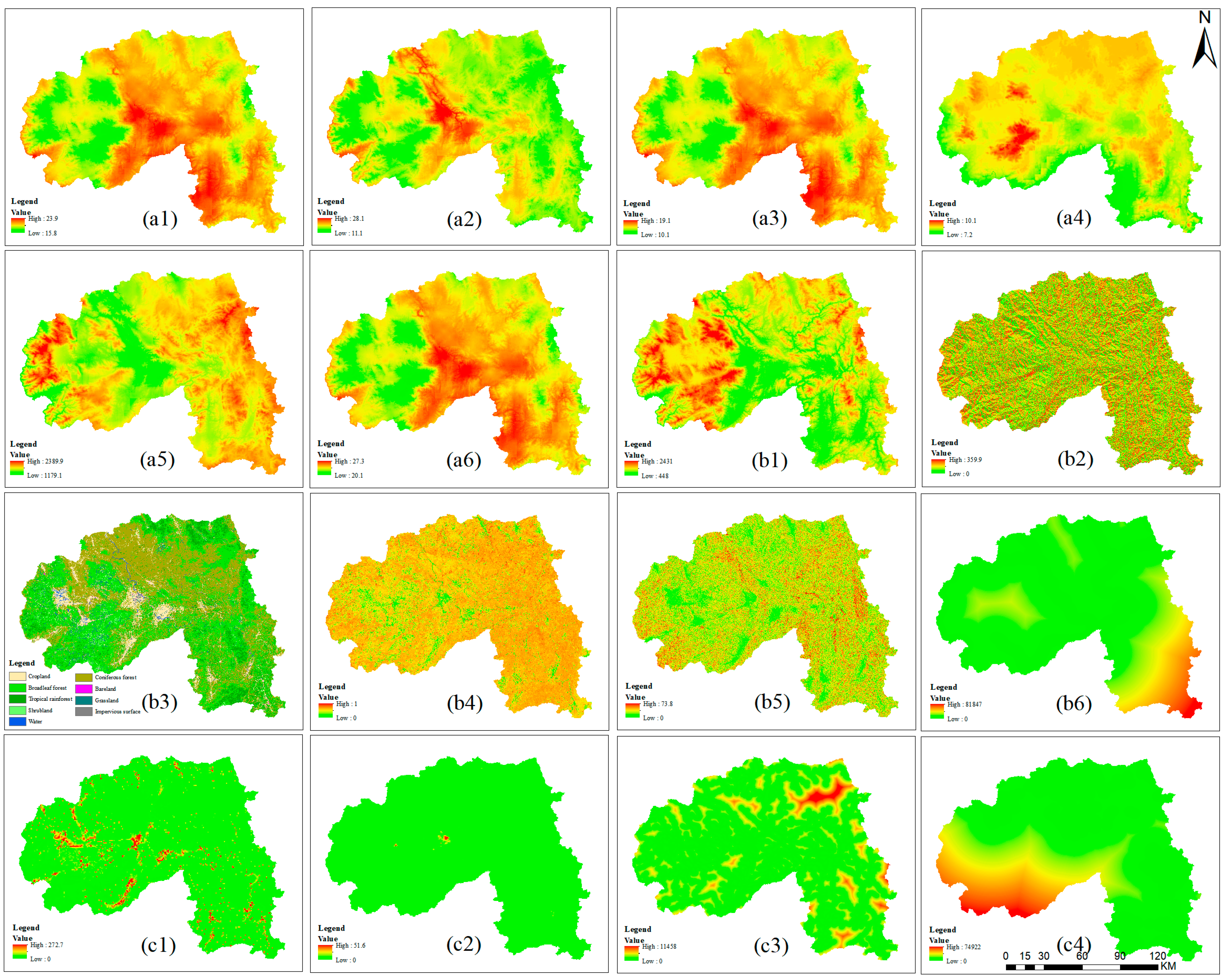
Figure 1. Research flowchart.
Remotesensing 15 01047 g001
Figure 2. The study area (the map contains elevation data and Asian elephant migration tracks) in Sipsongpanna Prefecture (Menghai County, Mengla County, and Jinghong City).
Remotesensing 15 01047 g002
Figure 3. Sixteen environmental factors under current climate conditions: (a1a6) climate factors: MAT, AHM, MCMT, TD, MAP, and MWMT; (b1b6) natural factors: Alt, Aspect, VCT, NDVI, Slope, and Dis_river; (c1c4) anthropogenic factors: PD, NL, Dis_road, and Dis_res. The definitions, units, and abbreviations of the environment variables are listed in Table 1.
Remotesensing 15 01047 g003
Figure 4. Results of the jackknife test to obtain the important values of the environmental factors influencing the distribution of Asian elephants in Sipsongpanna for (a1a3) non-anthropogenic interference (NAI) and (b1b3) anthropogenic interference (AI). The environmental variables and their abbreviations are listed in Table 1.
Remotesensing 15 01047 g004
Figure 5. The response curves of the dominant environmental variables affecting the distribution of Asian elephants in Sipsongpanna. Effects of altitude, mean annual precipitation, and mean warmest month temperature on the distribution of Asian elephants under NAI (Non-anthropogenic Interference, (a1a3)) and under AI (Anthropogenic Interference, (b1b3)).
Remotesensing 15 01047 g005
Figure 6. Distribution of Asian elephants in suitable areas in Sipsongpanna under current climatic conditions ((a) NAI: Non-anthropogenic Interference, (b) AI: Anthropogenic Interference).
Remotesensing 15 01047 g006
Figure 7. Predicted future suitable areas for Asian elephants in Sipsongpanna. (a1a6) Future suitable areas for 2025-RCP45, 2055-RCP45, 2085-RCP45, 2025-RCP85, 2055-RCP85, and 2085-RCP85 under NAI (Non-anthropogenic Interference). (b1b6) Future suitable areas for 2025-RCP45, 2055-RCP45, 2085-RCP45, 2025-RCP85, 2055-RCP85, and 2085-RCP85 under AI (Anthropogenic Influence).
Remotesensing 15 01047 g007
Figure 8. Changes in suitable areas for Asian elephants in Sipsongpanna under current and future climate scenarios ((a) high-suitability areas; (b) medium-suitability areas; (c) low-suitability areas; (d) non-suitability areas).
Remotesensing 15 01047 g008
Table 1. Environmental variables used in predicting the distribution of Asian elephants in Sipsongpanna.
TypeVariableDescriptionUnitSource and Preprocessing Method
Climate factorsMAT [8]Mean Annual Temperature°CClimateAP_v2.30, Original Value
MWMT [42]Mean Warmest Month Temperature°CClimateAP_v2.30, Original Value
MCMT [42]Mean Coldest Month Temperature°CClimateAP_v2.30, Original Value
TD [5]Temperature Difference between MWMT and MCMT°CClimateAP_v2.30, Original Value
MAP [41]Mean Annual PrecipitationmmClimateAP_v2.30, Original Value
AHM [8]Annual Heat. Moisture index (MAT + 10)/(MAP/1000) ClimateAP_v2.30, Original Value
Natural FactorsAlt [43]AltitudemASTER GDEM V3, Original Value
Slope [43]Slope°ASTER GDEM V3, Surface Analysis Tool Extraction
Aspect [43]Aspect ASTER GDEM V3, Surface Analysis Tool Extraction
VCT [44]Vegetation Cover Type Landsat8 OLI, Random Forest Classification
NDVI [44]Normalized Difference Vegetation Index Extraction calculated from Landsat8 OLI
Dis_river [44]Distance To Water ResourcemRivers, Euclidean distance
Anthropogenic influence factorsPD [34]Population Densitypeople/km²Calculated from land cover type and population to obtain
NL [34]Nighttime Light Resampling according to NPPVIIRS
Dis_road [45]Distance To RoadsmRoads, Euclidean distance
Dis_res [45]Distance To ResidentialmResidential Locations, Euclidean distance
Table 2. Cumulative percentage contribution of environmental variables affecting Asian elephant distribution in Sipsongpanna under NAI and AI.
TypeVariableDescriptionPercent Contribution/%Cumulative Percentage/%
Non-anthropogenic Interference (NAI)AltAltitude37.137.1
MAPMean Annual Precipitation25.562.6
MWMTMean Warmest Month Temperature22.485
TDTemperature Difference between MWMT and MCMT8.893.8
Dis_riverDistance to Water Resources3.397.1
AspectAspect2.9100
Anthropogenic Interference (AI)AltAltitude42.542.5
MAPMean Annual Precipitation23.766.2
MWMTMean Warmest Month Temperature14.981.1
TDTemperature Difference between MWMT and MCMT5.186.2
Dis_roadDistance to Roads4.190.3
PDPopulation Density494.3
AspectAspect2.596.8
Dis_resDistance to Residential Areas2.299
Dis_riverDistance to Water Resources1100
Disclaimer/Publisher’s Note: The statements, opinions and data contained in all publications are solely those of the individual author(s) and contributor(s) and not of MDPI and/or the editor(s). MDPI and/or the editor(s) disclaim responsibility for any injury to people or property resulting from any ideas, methods, instructions or products referred to in the content.

