Impact of Climate Change Parameters on Groundwater Level: Implications for Two Subsidence Regions in Iran Using Geodetic Observations and Artificial Neural Networks (ANN)
Abstract
1. Introduction
2. Background and Methodology
2.1. Tropospheric Correction to InSAR Data
2.2. Downscaling and Long-Term Prediction
1-. Predictor and predictand data and their relationships are not affected by human-caused climate change and can be transferred to the next decades.
2-. All downscaled parameters are obtained using the available data in the base period because it is assumed that, during the decades belonging to this time period, the data are of a higher quality and are more accessible than in other periods and, also, that the risk of instability in the relationship between predictor variables is small.
3-. In climate simulations, it is assumed that the data follow the normal distribution.
2.3. ANN for Groundwater Level Prediction
2.4. PWV as a Key Indicator
2.5. Evapotranspiration Estimation
2.6. Effective Rainfall
2.7. Validation Methods
3. Study Area and Data Set
4. Processing Results and Discussions
4.1. Subsidence Detection
4.2. Downscaling and Prediction of Meteorological Parameters Using SDSM
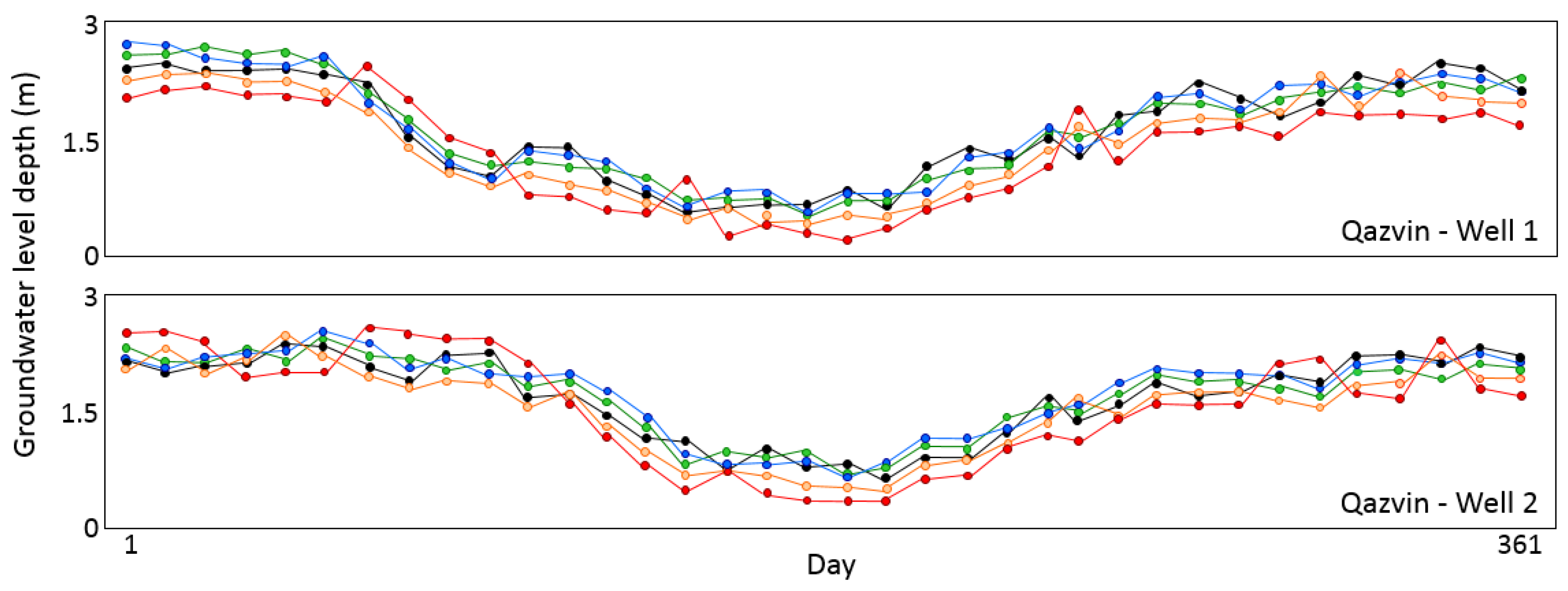
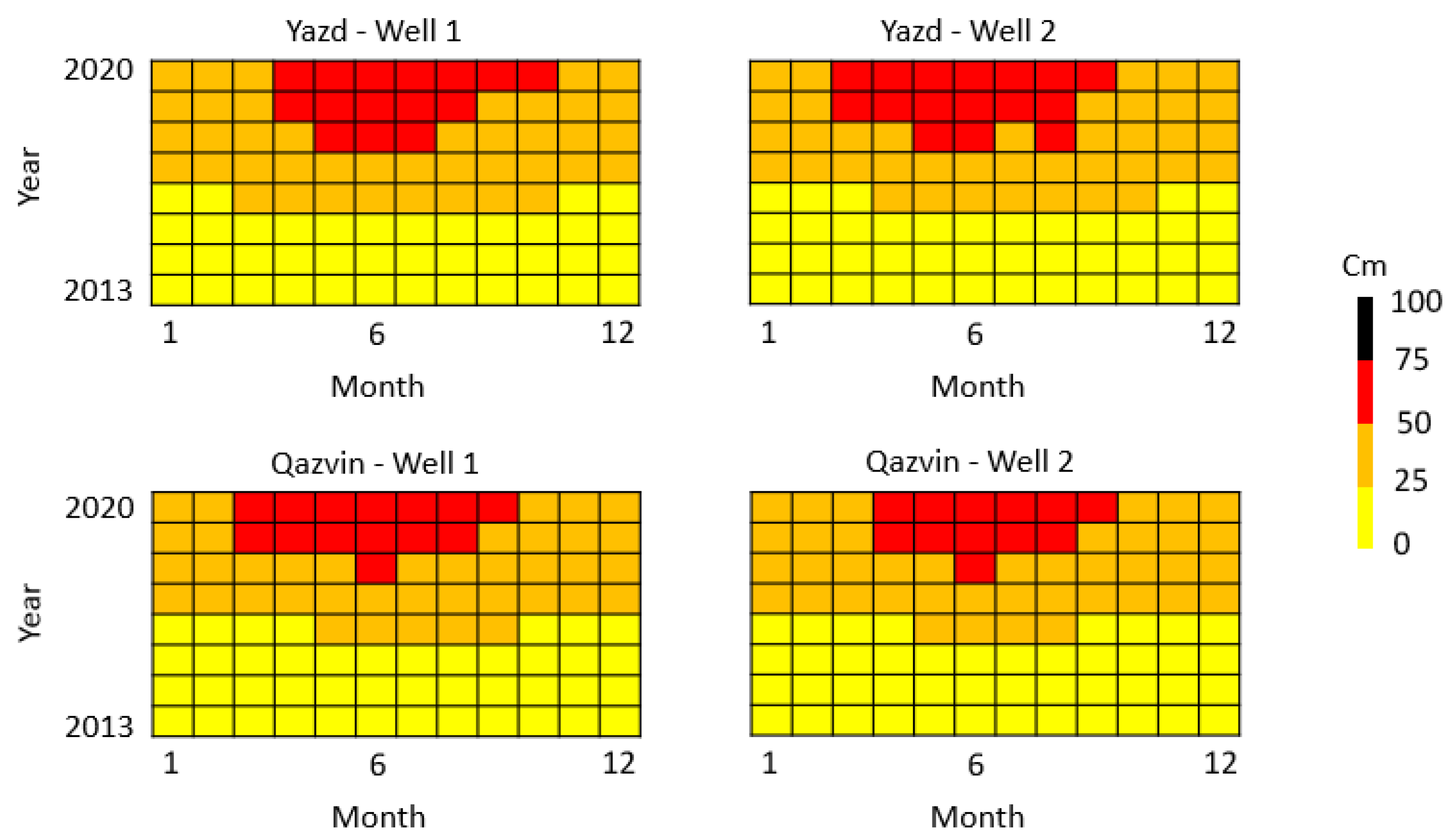
4.3. Groundwater Level Prediction from 2013 to 2020
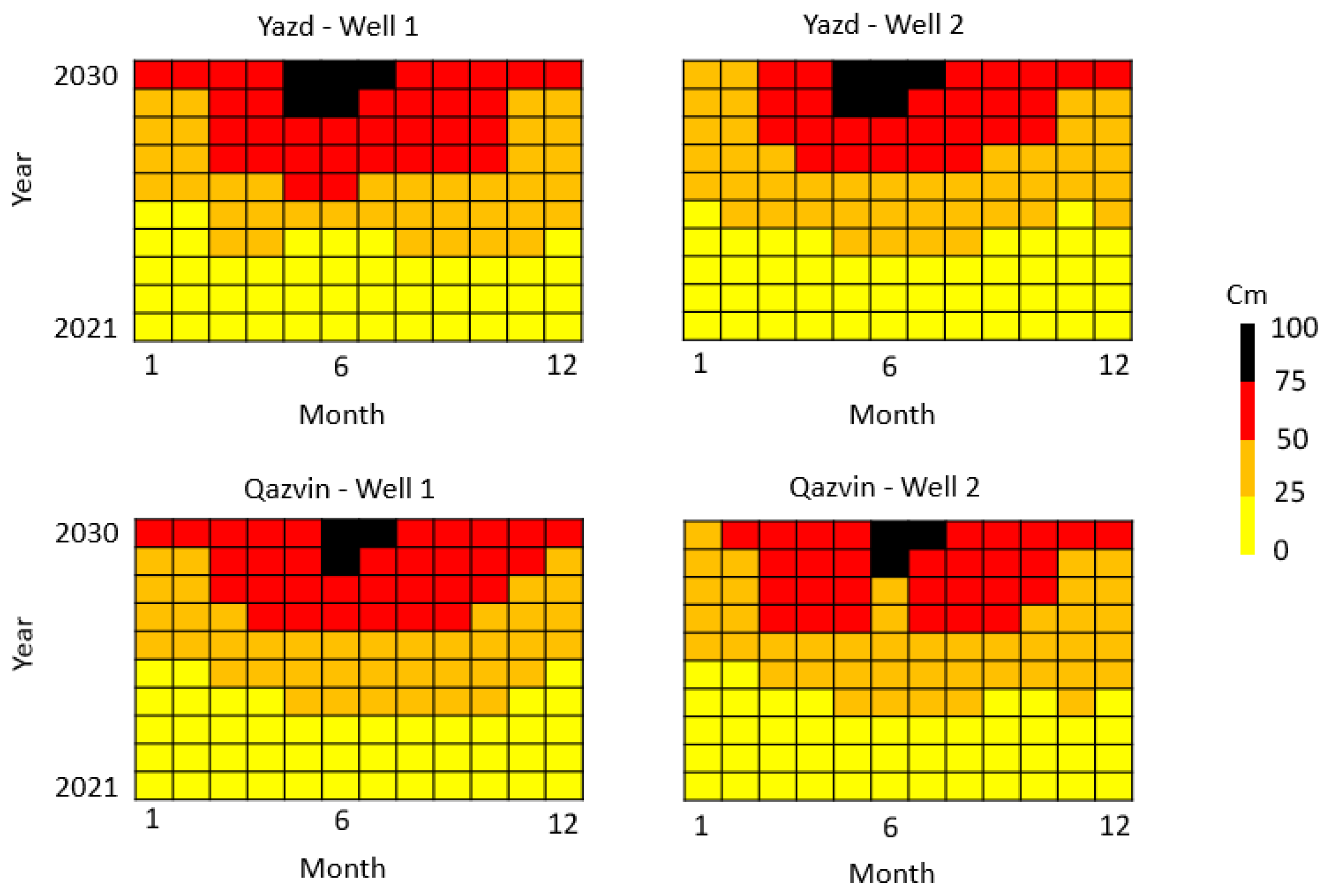
4.4. Groundwater Level Prediction from 2021 to 2030
5. Summary and Conclusions
Author Contributions
Funding
Data Availability Statement
Acknowledgments
Conflicts of Interest
References
- Lüthi, D.; Floch, M.L.; Bereiter, B.; Blunier, T.; Barnola, J.M.; Siegenthaler, U.; Raynaud, D.; Jouzel, J.; Fischer, H.; Kawamura, K.; et al. High-Resolution Carbon Dioxide Concentration Record 650,000-800,000 Years Before Present. Nature 2008, 453, 379–382. [Google Scholar] [CrossRef] [PubMed]
- IPCC. Climate Change 2007: Synthesis Report. Contribution of Working Groups I, II and III to the Fourth Assessment Report of the Intergovernmental Panel on Climate Change; Core Writing Team, Pachauri, R.K., Reisinger, A., Eds.; IPCC: Geneva, Switzerland, 2007; 104p. [Google Scholar]
- Horton, E.B. Geographical Distribution of Changes in Maximum and Minimum Temperatures. Atmos. Res. 1995, 37, 102–117. [Google Scholar] [CrossRef]
- Rosenzweig, C.; Karoly, D.; Vicarelli, M.; Neofotis, P.; Wu, Q.; Casassa, G.; Menzel, A.; Root, T.L.; Estrella, N.; Seguin, B.; et al. Attributing Physical and Biological Impacts to Anthropogenic Climate Change. Nature 2008, 453, 353–358. [Google Scholar] [CrossRef]
- Cohen, S.J. Impacts of CO2-induced Climatic change on water resources in the Great Lakes Basin. Clim. Chang. 1986, 8, 135–153. [Google Scholar] [CrossRef]
- Holman, I.P. Impacts climate change on groundwater recharge-uncertainty, shortcomings, and the way forward. Hydrogeology 2006, 14, 637–647. [Google Scholar] [CrossRef]
- Jykama, M.I.; Sykes, J.F. The impact of climate change on spatially varying groundwater recharge in the Grand River watershed (Ontario). Hydrology 2007, 338, 237–250. [Google Scholar] [CrossRef]
- Ng, G.H.C.; McLaughlin, D.; Entekhabi, D.; Scanlon, B.R. Probabilistic analysis of climate change on groundwater recharge. Water Resour. Res. 2010, 46, 1–18. [Google Scholar] [CrossRef]
- Luoma, S.; Okkonen, J. Impacts of Future Climate Change and Baltic Sea Level Rise on Groundwater Recharge. Groundwater Levels, and Surface Leakage in the Hanko Aquifer in Southern Finland. Water 2014, 6, 3671–3700. [Google Scholar] [CrossRef]
- Ertürk, A.; Ekdal, A.; Gürel, M.; Karakaya, N.; Guzel, C.; Gönenç, E. Evaluating the impact of climate change on groundwater resources in a small Mediterranean watershed. Scince Total Environ. 2016, 499, 437–447. [Google Scholar] [CrossRef] [PubMed]
- House, A.; Acreman, M.; Sorensen, J.; Thompson, J. Hydroecological impacts of climate change modelled for a lowland UK wetland. Geophys. Res. Abstr. 2017, 17, 2015–4671. [Google Scholar]
- Burgan, H.I. Comparison of different ANN (FFBP, GRNN, RBF) algorithms and Multiple Linear Regression for daily streamflow prediction in Kocasu River, Turkey. Fresenius Environ. Bull. 2022, 31, 4699–4708. [Google Scholar]
- Trabelsi, F.; Bel Hadj Ali, S.; Lee, S. Comparison of Novel Hybrid and Benchmark Machine Learning Algorithms to Predict Groundwater Potentiality: Case of a Drought-Prone Region of Medjerda Basin, Northern Tunisia. Remote Sens. 2023, 15, 152. [Google Scholar] [CrossRef]
- Haji-Aghajany, S.; Amerian, Y. Assessment of InSAR tropospheric signal correction methods. J. Appl. Remote Sens. 2020, 14, 044503. [Google Scholar] [CrossRef]
- Haji-Aghajany, S.; Amerian, Y. Atmospheric phase screen estimation for land subsidence evaluation by InSAR time series analysis in Kurdistan. Iran J. Atmos. Sol. -Terr. Phys. 2020, 164, 81–88. [Google Scholar] [CrossRef]
- Zebker, H.A.; Villasenor, J. Decorrelation in interferometric radar echoes, Geoscience and Remote Sensing. IEEE Trans. 1992, 30, 950–959. [Google Scholar] [CrossRef]
- Hanssen, R.F. Radar Interferometry: Data Interpretation and Error Analysis; Kluwer Academic Pub: Dordrecht, The Netherlands, 2001. [Google Scholar]
- Haji-Aghajany, S.; Voosoghi, B.; Yazdian, A. Estimation of north Tabriz fault parameters using neural networks and 3D tropospherically corrected surface displacement field. Geomatics. Nat. Hazards Risk 2017, 8, 918–932. [Google Scholar] [CrossRef]
- Ferretti, A.; Prati, C.; Rocca, F. Permanent scatterers in SAR interferometry, Geoscience and Remote Sensing. IEEE Trans. 2001, 39, 8–20. [Google Scholar] [CrossRef]
- Hooper, A.; Zebker, H.; Segall, P.; Kampes, B. A new method for measuring deformation on volcanoes and other natural terrains using InSAR persistent scatterers. Geophys. Res. Lett. 2004, 31, L23611. [Google Scholar] [CrossRef]
- Ferretti, A.; Fumagalli, A.; Novali, F.; Prati, C.; Rocca, F.; Rucci, A. A New Algorithm for Processing Interferometric Data-Stacks: SqueeSAR, Geoscience and Remote Sensing. IEEE Trans. 2011, 49, 3460–3470. [Google Scholar] [CrossRef]
- Berardino, P.; Fornaro, G.; Lanari, R.; Sansosti, E. A new algorithm for surface deformation monitoring based on small baseline differential SAR interferograms, Geoscience and Remote Sensing. IEEE Trans. 2002, 40, 2375–2383. [Google Scholar] [CrossRef]
- Bekaert, D.P.S.; Hooper, A.; Wright, T.J. A spatially-variable power-law tropospheric correction 1145 technique for InSAR data. J. Geophys. Res. Solid Earth 2015, 120, 1345–1356. [Google Scholar] [CrossRef]
- Doin, M.P.; Lasserre, C.; Peltzer, G.; Cavalié, O.; Doubre, C. Corrections of stratified tropospheric delays in SAR interferometry: Validation with global atmospheric models. J. Appl. Geophys. 2009, 69, 35–50. [Google Scholar] [CrossRef]
- Li, Z.; Fielding, E.; Cross, P.; Preusker, R. Advanced InSAR atmospheric correction: MERIS/MODIS combination and stacked water vapour models. Int. J. Remote Sens. 2009, 30, 3343–3363. [Google Scholar] [CrossRef]
- Yu, C.; Li, Z.; Penna, N.T. Interferometric synthetic aperture radar atmospheric correction using a GPS based iterative tropospheric decomposition model. Remote Sens. Environ. 2018, 204, 109–121. [Google Scholar] [CrossRef]
- Haji-Aghajany, S.; Amerian, Y. An investigation of three dimensional ray tracing method efficiency in precise point positioning by tropospheric delay correction. J. Earth Space Phys. 2018, 44, 39–52. [Google Scholar] [CrossRef]
- Haji-Aghajany, S.; Voosoghi, B.; Amerian, Y. Estimating the slip rate on the north Tabriz fault (Iran) from InSAR measurements with tropospheric correction using 3D ray tracing technique. Adv. Space Res. 2019, 64, 2199–2208. [Google Scholar] [CrossRef]
- Cao, Y.; Jónsson, S.; Li, Z. Advanced InSAR tropospheric corrections from global atmospheric models that incorporate spatial stochastic properties of the troposphere. J. Geophys. Res. Solid Earth 2021, 126, e2020JB020952. [Google Scholar] [CrossRef]
- Hobiger, T.; Ichikawa, R.; Koyama, R.; Kondo, T. Fast and accurate ray-tracing algorithms for real-time space geodetic applications using numerical weather models. J. Geophys. Res. 2008, 113, 1–14. [Google Scholar] [CrossRef]
- Haji-Aghajany, S.; Amerian, Y. Three dimensional ray tracing technique for tropospheric water vapor tomography using GPS measurements. J. Atmos. Sol. -Terr. Phys. 2017, 164, 81–88. [Google Scholar] [CrossRef]
- Haji-Aghajany, S.; Amerian, Y. Hybrid Regularized GPS Tropospheric Sensing Using 3-D Ray Tracing Technique. IEEE Geosci. Remote Sens. Lett. 2018, 15, 1475–1479. [Google Scholar] [CrossRef]
- Jolivet, R.; Agram, P.S.; Lin, N.Y.; Simons, M.; Doin, M.P.; Peltzer, G.; Li, Z. Improving InSAR geodesy using global atmospheric models. J. Geophys. Res. Solid Earth 2014, 119, 2324–2341. [Google Scholar] [CrossRef]
- Khalili, M.A.; Voosoghi, B.; Guerriero, L.; Haji-Aghajany, S.; Calcaterra, D.; Di Martire, D. Mapping of Mean Deformation Rates Based on APS-Corrected InSAR Data Using Unsupervised Clustering Algorithms. Remote Sens. 2023, 15, 529. [Google Scholar] [CrossRef]
- Dubrule, O. Comparing splines and kriging. Comput. Geosci. 1984, 10, 327–338. [Google Scholar] [CrossRef]
- Prajapat, D.K.; Choudhary, M. Spatial distribution of precipitation extremes over Rajasthan using CORDEX data. ISH J. Hydraul. Eng. 2021, 27, 289–300. [Google Scholar] [CrossRef]
- Rahman Hashmi, M.Z.U.; Shamseldin, A.Y.; Melville, B.W. Comparison of MLP-ANN Scheme and SDSM as Tools for Providing Downscaled Precipitation for Impact Studies at Daily Time Scale. J. Earth Sci. Clim. Chang. 2018, 9, 475. [Google Scholar] [CrossRef]
- Haji-Aghajany, S.; Amerian, Y.; Amiri-Simkooei, A. Function-Based Troposphere Tomography Technique for Optimal Downscaling of Precipitation. Remote Sens. 2022, 14, 2548. [Google Scholar] [CrossRef]
- Gordon, C.; Cooper, C.; Senior, C.; Banks, H.; Gregory, J.; Johns, T.; Mitchell, J.; Wood, R.A. The simulation of SST, sea ice extents and ocean heat transports in a version of the Hadley Centre coupled model without flux adjustments. J. Clim. Dyn. 2000, 16, 147–168. [Google Scholar] [CrossRef]
- Wilby, R.L.; Tomlinson, O.J.; Dawson, C.W. Multi-Site Simulation of Precipitation By Conditional Resampling. Clim. Res. 2003, 23, 183–194. [Google Scholar] [CrossRef]
- Banerjee, P.; Prasad, R.K.; Singh, V.S. Forecasting of groundwater level in hard rock region using artificial neural network. Environ. Geol. 2009, 58, 1239–1246. [Google Scholar] [CrossRef]
- Chang, J.; Wang, G.; Mao, T. Simulation and prediction of supra permafrost groundwater level variation in response to climate change using a neural network model. J. Hydrol. 2015, 529, 1211–1220. [Google Scholar] [CrossRef]
- Levenberg, K.A. A Method for the solution of certain non-linear problems in least squares. Q. Appl. Math. 1944, 2, 164–168. [Google Scholar] [CrossRef]
- Marquardt, D.W. An algorithm for least-squares estimation of nonlinear parameters. J. Soc. Ind. Appl. Math. 1963, 11, 431–441. [Google Scholar] [CrossRef]
- Dach, R.; Lutz, S.; Walser, P.; Fridez, P. Bernese GNSS Software Version 5.2; User manual, Astronomical Institute, University of Bern, Bern Open Publishing: Bern, Switzerland, 2015; ISBN 978-3-906813-05-9. [Google Scholar] [CrossRef]
- Bevis, M.; Businger, S.; Herring, T.A.; Rocken, C.; Anthes, R.A.; Ware, R.H. GPS meteorology: Remote sensing of atmospheric water vapor using the Global Positioning System. J. Geophys. Res. Atmos. 1992, 97, 15787–15801. [Google Scholar] [CrossRef]
- Haji-Aghajany, S.; Amerian, Y.; Verhagen, S.; Rohm, W.; Schuh, H. The effect of function-based and voxel-based tropospheric tomography techniques on the GNSS positioning accuracy. J. Geod. 2021, 95, 1–17. [Google Scholar] [CrossRef]
- Saastamoinen, J. Atmospheric correction for the troposphere and stratosphere in radio ranging satellites. Use Artif. Satell. Geod. 1972, 15, 247–251. [Google Scholar]
- Haji-Aghajany, S.; Amerian, Y.; Verhagen, S. B-spline function-based approach for GPS tropospheric tomography. GPS Solut. 2020, 24, 88. [Google Scholar] [CrossRef]
- Allen, R.G.; Pereira, L.S.; Raes, D.; Smith, M. Crop Evapotranspiration. FAO Irrigation and Drainage; Paper No. 56; Food and Agriculture Organization of the United Nations: Rome, Italy, 1998. [Google Scholar]
- Thornthwaite, C.W. An approach toward a rational classification of climate. Geogr. Rev. 1948, 38, 55–94. [Google Scholar] [CrossRef]
- Zhao, Q.; Sun, T.; Zhang, T.; He, L.; Zhang, Z.; Shen, Z.; Xiong, S. High-Precision Potential Evapotranspiration Model Using GNSS Observation. Remote Sens. 2021, 13, 4848. [Google Scholar] [CrossRef]
- Rahman, M.M.; Islam, M.O.; Hasanuzzaman, M. Study of effective rainfall for Irrigated Agriculture in South-Eastern Part of Bangladesh. World J. Agric. Sci. 2008, 4, 453–457. [Google Scholar]
- Andrade, C. The P-Value and Statistical Significance: Misunderstandings, Explanations, Challenges, and Alternatives. Indian J. Psychol. Med. 2019, 41, 210–215. [Google Scholar] [CrossRef]
- United Nations (2021) World Population Prospects: The 2019 Revision. Volume III: Analytical Report. Available online: https://www.un.org/development/desa/pd/news/world-population-prospects-2019-0 (accessed on 1 January 2023).
- Morteza, A.; Mahmood, H.; Mohammadreza, L.; Kamran, D. Estimation of water demand function in agricultural, urban and industrial sectors in Mashhad Plain. Mod. Appl. Sci. 2019, 13, 1–11. [Google Scholar]
- Hersbach, H.; Dee, D. ERA5 Reanalysis is in Production; ECMWF Newsletter 147; ECMWF: Reading, UK, 2016. [Google Scholar]






| Parameter | Area | Jan | Feb | Mar | Apr | may | Jun | Jul | Aug | Sep | Oct | Nov | Dec |
|---|---|---|---|---|---|---|---|---|---|---|---|---|---|
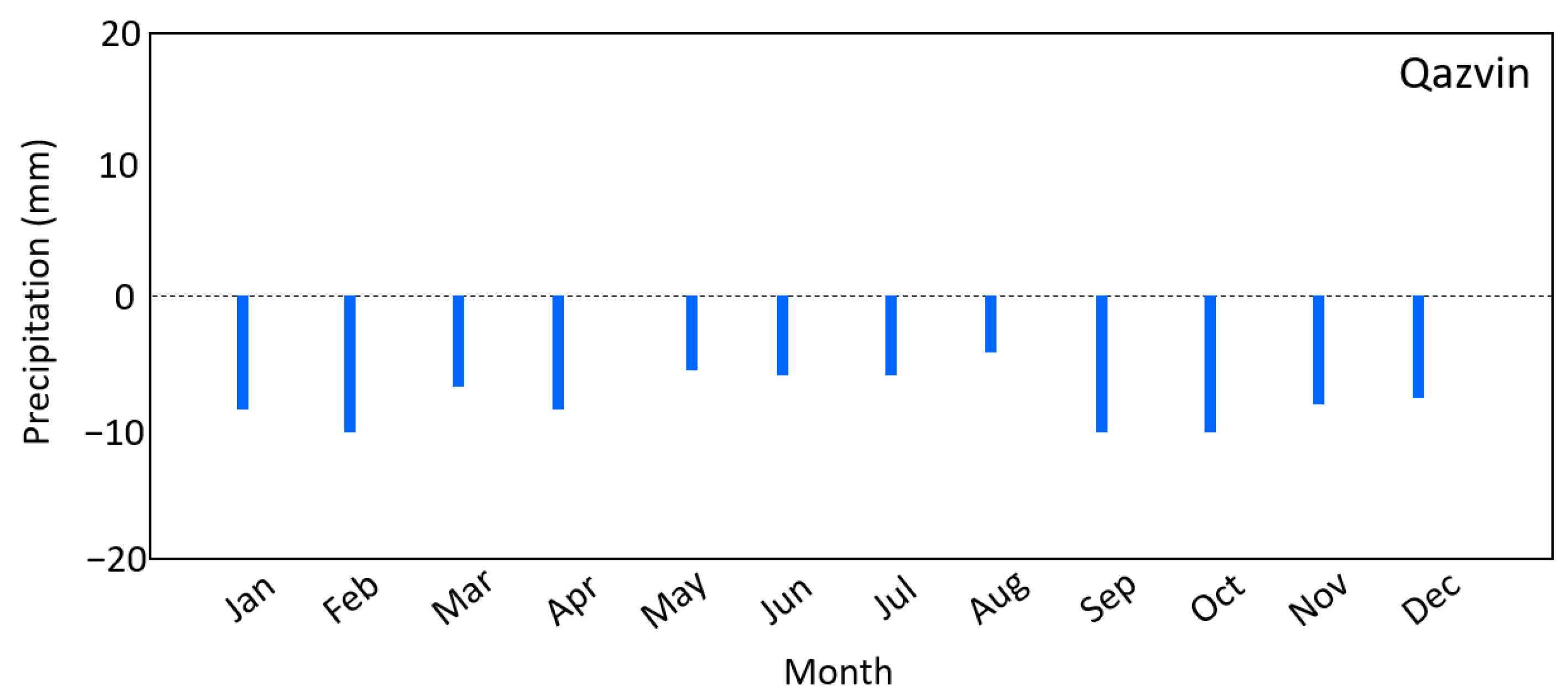
| Average precipitation (cm) | Qazvin | 0.50 | 0.62 | 0.78 | 0.75 | 0.41 | 0.09 | 0.05 | 0.05 | 0.05 | 0.33 | 0.56 | 0.49 |
| Yazd | 0.28 | 0.26 | 0.37 | 0.30 | 0.16 | 0.01 | 0.01 | 0.00 | 0.00 | 0.05 | 0.17 | 0.22 | |
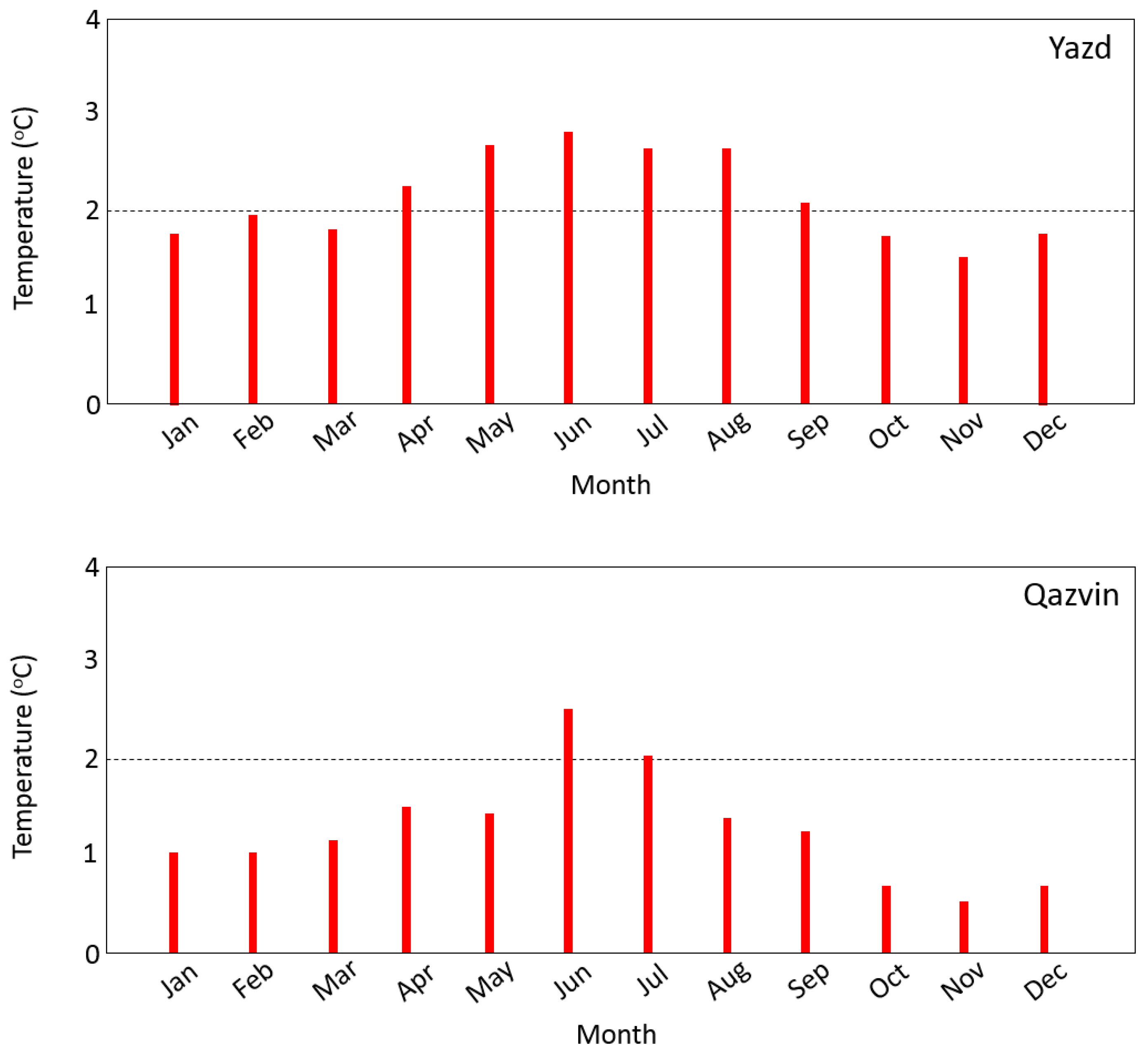
| Average temperature (k) | Qazvin | 268.8 | 271.9 | 276.9 | 277.0 | 281.8 | 285.9 | 287.2 | 285.9 | 281.0 | 274.2 | 268.1 | 263.8 |
| Yazd | 282.3 | 285.7 | 289.8 | 289.1 | 294.4 | 298.3 | 298.7 | 296.8 | 292.3 | 285.7 | 280.3 | 276.6 |
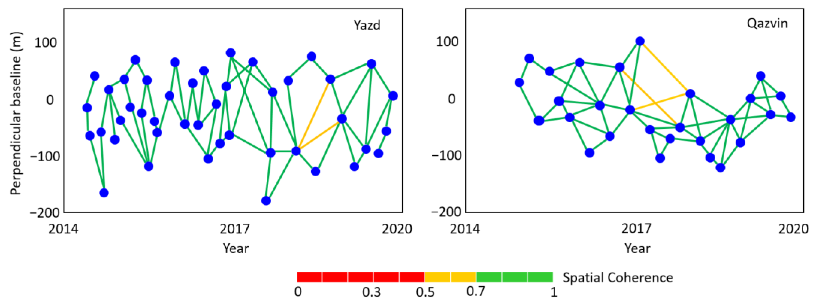
| Area | Mission | Product | Track | Flight Direction | Beam Mode | Time Span |
|---|---|---|---|---|---|---|
| Qazvin | Sentinel-1A | S1A-IW-SLC | 108 | Descending | IW | 2015–2020 |
| Yazd | Sentinel-1A | S1A-IW-SLC | 130 | Ascending | IW | 2015–2020 |
| Year | Area | Min (m) | Max (m) | Mean (m) | Median (m) |
|---|---|---|---|---|---|
| 2013 2014 2015 2016 2017 2018 2019 2020 | Qazvin (2 wells) | 0.49 0.51 0.58 0.47 0.59 0.57 0.60 0.62 | 1.86 1.98 2.23 2.39 2.64 2.63 2.71 2.81 | 1.31 1.29 1.13 1.39 1.28 1.41 1.53 1.61 | 1.24 1.15 1.11 1.20 1.39 1.47 1.43 1.50 |
| 2013 2014 2015 2016 2017 2018 2019 2020 | Yazd (2 wells) | 0.50 0.48 0.59 0.63 0.58 0.61 0.67 0.71 | 2.54 2.64 2.87 2.86 3.12 3.25 3.39 3.31 | 1.42 1.49 1.69 1.87 1.88 2.01 2.25 2.19 | 1.31 1.28 1.54 1.63 2.01 2.15 2.11 2.40 |
| Area | Variable (°C) | RMSE (°C) | NSE | R2 |
|---|---|---|---|---|
| Qazvin | Tmax | 0.41 | 0.77 | 0.85 |
| Tmin | 0.31 | 0.83 | 0.87 | |
| Yazd | Tmax | 0.36 | 0.79 | 0.85 |
| Tmin | 0.43 | 0.84 | 0.89 |
| Area | Variable (mm) | RMSE (mm) | NSE | R2 |
|---|---|---|---|---|
| Qazvin | Precipitation | 2.21 | 0.75 | 0.84 |
| Yazd | Precipitation | 2.02 | 0.71 | 0.82 |
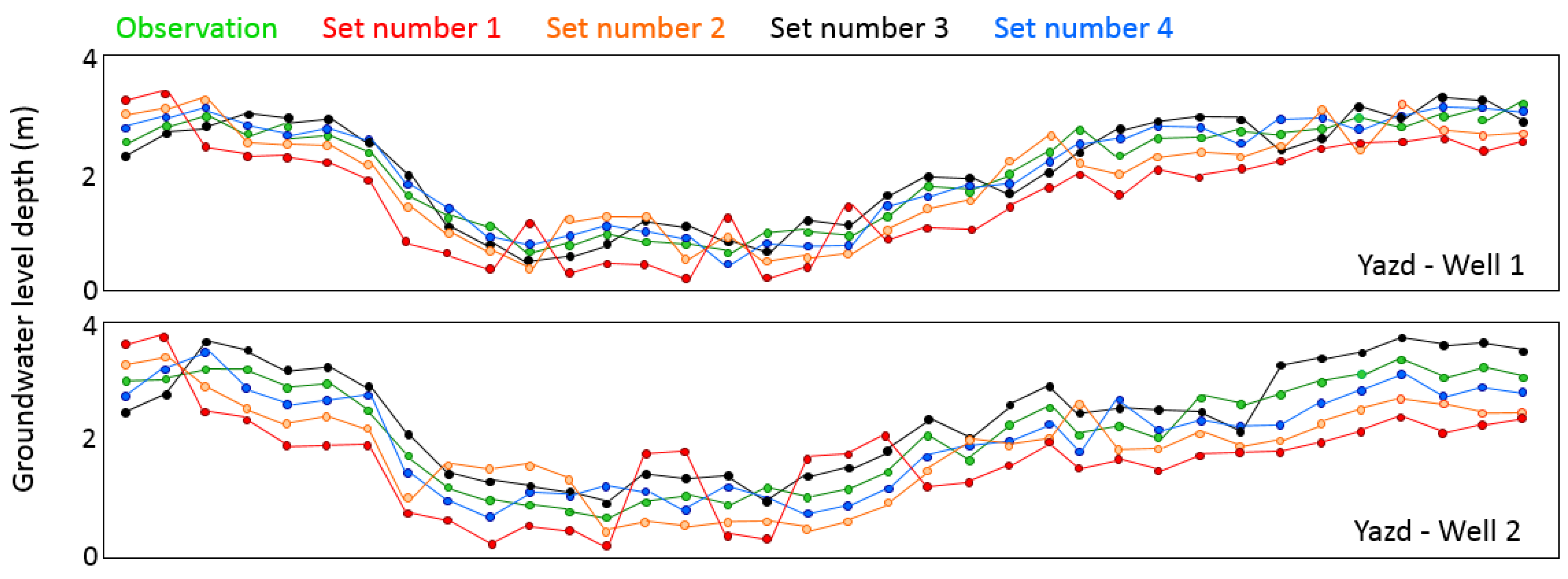
| Set Number | Inputs |
|---|---|
| 1 | Precipitation, Tmin, Tmax, SR, D |
| 2 | Precipitation, Tmin, Tmax, SR, D, PWV |
| 3 | Precipitation, Tmin, Tmax, SR, D, ET |
| 4 | Precipitation, Tmin, Tmax, SR, D, ET, PWV |
| Area | Set Number | RMSE (m) | NSE | Correlation |
|---|---|---|---|---|
| Qazvin | 1 | 0.989 | 0.71 | 0.79 |
| Qazvin | 2 | 0.615 | 0.75 | 0.82 |
| Qazvin | 3 | 0.361 | 0.81 | 0.89 |
| Qazvin | 4 | 0.189 | 0.86 | 0.93 |
| Yazd | 1 | 1.023 | 0.70 | 0.74 |
| Yazd | 2 | 0.084 | 0.73 | 0.81 |
| Yazd | 3 | 0.598 | 0.80 | 0.87 |
| Yazd | 4 | 0.241 | 0.84 | 0.91 |
| Month | Jan | Feb | Mar | Apr | May | Jun | Jul | Aug | Sep | Oct | Nov | Dec | |
|---|---|---|---|---|---|---|---|---|---|---|---|---|---|
| Precipitation | Yazd Well 1 | 0.39 | 0.56 | 0.49 | 0.54 | 0.58 | 0.61 | 0.68 | 0.51 | 0.51 | 0.68 | 0.73 | 0.62 |
| Yazd Well 2 | 0.40 | 0.35 | 0.37 | 0.48 | 0.55 | 0.63 | 0.69 | 0.59 | 0.55 | 0.63 | 0.69 | 0.66 | |
| Qazvin Well 1 | 0.39 | 0.46 | 0.51 | 0.59 | 0.50 | 0.48 | 0.62 | 0.51 | 0.68 | 0.63 | 0.75 | 0.72 | |
| Qazvin Well 2 | 0.43 | 0.40 | 0.49 | 0.51 | 0.57 | 0.51 | 0.60 | 0.63 | 0.71 | 0.61 | 0.68 | 0.66 | |
| Temperature | Yazd Well 1 | −0.41 | −0.37 | −0.47 | −0.55 | −0.59 | −0.69 | −0.73 | −0.75 | −0.62 | −0.54 | −0.48 | −0.44 |
| Yazd Well 2 | −0.41 | −0.42 | −0.44 | −0.57 | −0.65 | −0.63 | −0.70 | −0.67 | −0.59 | −0.58 | −0.68 | −0.69 | |
| Qazvin Well 1 | −0.36 | −0.43 | −0.59 | −0.55 | −0.63 | −0.66 | −0.62 | −0.76 | −0.71 | −0.66 | −0.59 | −0.51 | |
| Qazvin Well 2 | −0.40 | −0.51 | −0.46 | −0.57 | −0.63 | −0.59 | −0.69 | −0.74 | −0.71 | −0.68 | −0.61 | −0.59 | |
| Month | Jan | Feb | Mar | Apr | May | Jun | Jul | Aug | Sep | Oct | Nov | Dec | |
|---|---|---|---|---|---|---|---|---|---|---|---|---|---|
| Precipitation | Yazd Well 1 | 0.31 | 0.39 | 0.41 | 0.61 | 0.50 | 0.63 | 0.69 | 0.51 | 0.43 | 0.65 | 0.62 | 0.68 |
| Yazd Well 2 | 0.31 | 0.35 | 0.37 | 0.47 | 0.51 | 0.55 | 0.50 | 0.61 | 0.52 | 0.58 | 0.63 | 0.68 | |
| Qazvin Well 1 | 0.31 | 0.33 | 0.43 | 0.59 | 0.68 | 0.69 | 0.73 | 0.76 | 0.72 | 0.62 | 0.69 | 0.61 | |
| Qazvin Well 2 | 0.31 | 0.40 | 0.51 | 0.59 | 0.58 | 0.63 | 0.66 | 0.67 | 0.71 | 0.70 | 0.62 | 0.53 | |
| Temperature | Yazd Well 1 | −0.37 | −0.42 | −0.53 | −0.57 | −0.61 | −0.52 | −0.69 | −0.61 | −0.59 | −0.55 | −0.51 | −0.61 |
| Yazd Well 2 | −0.40 | −0.33 | −0.61 | −0.55 | −0.51 | −0.61 | −0.68 | −0.53 | −0.48 | −0.54 | −0.49 | −0.57 | |
| Qazvin Well 1 | −0.37 | −0.39 | −0.44 | −0.51 | −0.59 | −0.52 | −0.46 | −0.41 | −0.44 | −0.58 | −0.51 | −0.58 | |
| Qazvin Well 2 | −0.44 | −0.45 | −0.51 | −0.58 | −0.64 | −0.67 | −0.63 | 0.51 | −0.69 | −0.66 | 0.53 | −0.49 | |
Disclaimer/Publisher’s Note: The statements, opinions and data contained in all publications are solely those of the individual author(s) and contributor(s) and not of MDPI and/or the editor(s). MDPI and/or the editor(s) disclaim responsibility for any injury to people or property resulting from any ideas, methods, instructions or products referred to in the content. |
© 2023 by the authors. Licensee MDPI, Basel, Switzerland. This article is an open access article distributed under the terms and conditions of the Creative Commons Attribution (CC BY) license (https://creativecommons.org/licenses/by/4.0/).
Share and Cite
Haji-Aghajany, S.; Amerian, Y.; Amiri-Simkooei, A. Impact of Climate Change Parameters on Groundwater Level: Implications for Two Subsidence Regions in Iran Using Geodetic Observations and Artificial Neural Networks (ANN). Remote Sens. 2023, 15, 1555. https://doi.org/10.3390/rs15061555
Haji-Aghajany S, Amerian Y, Amiri-Simkooei A. Impact of Climate Change Parameters on Groundwater Level: Implications for Two Subsidence Regions in Iran Using Geodetic Observations and Artificial Neural Networks (ANN). Remote Sensing. 2023; 15(6):1555. https://doi.org/10.3390/rs15061555
Chicago/Turabian StyleHaji-Aghajany, Saeid, Yazdan Amerian, and Alireza Amiri-Simkooei. 2023. "Impact of Climate Change Parameters on Groundwater Level: Implications for Two Subsidence Regions in Iran Using Geodetic Observations and Artificial Neural Networks (ANN)" Remote Sensing 15, no. 6: 1555. https://doi.org/10.3390/rs15061555
APA StyleHaji-Aghajany, S., Amerian, Y., & Amiri-Simkooei, A. (2023). Impact of Climate Change Parameters on Groundwater Level: Implications for Two Subsidence Regions in Iran Using Geodetic Observations and Artificial Neural Networks (ANN). Remote Sensing, 15(6), 1555. https://doi.org/10.3390/rs15061555


