

The Potential of New LiDAR Datasets for Archaeology in Switzerland


Abstract
:1. LiDAR in Archaeology
2. Forested Areas in Switzerland
3. The Swisstopo Data Collection
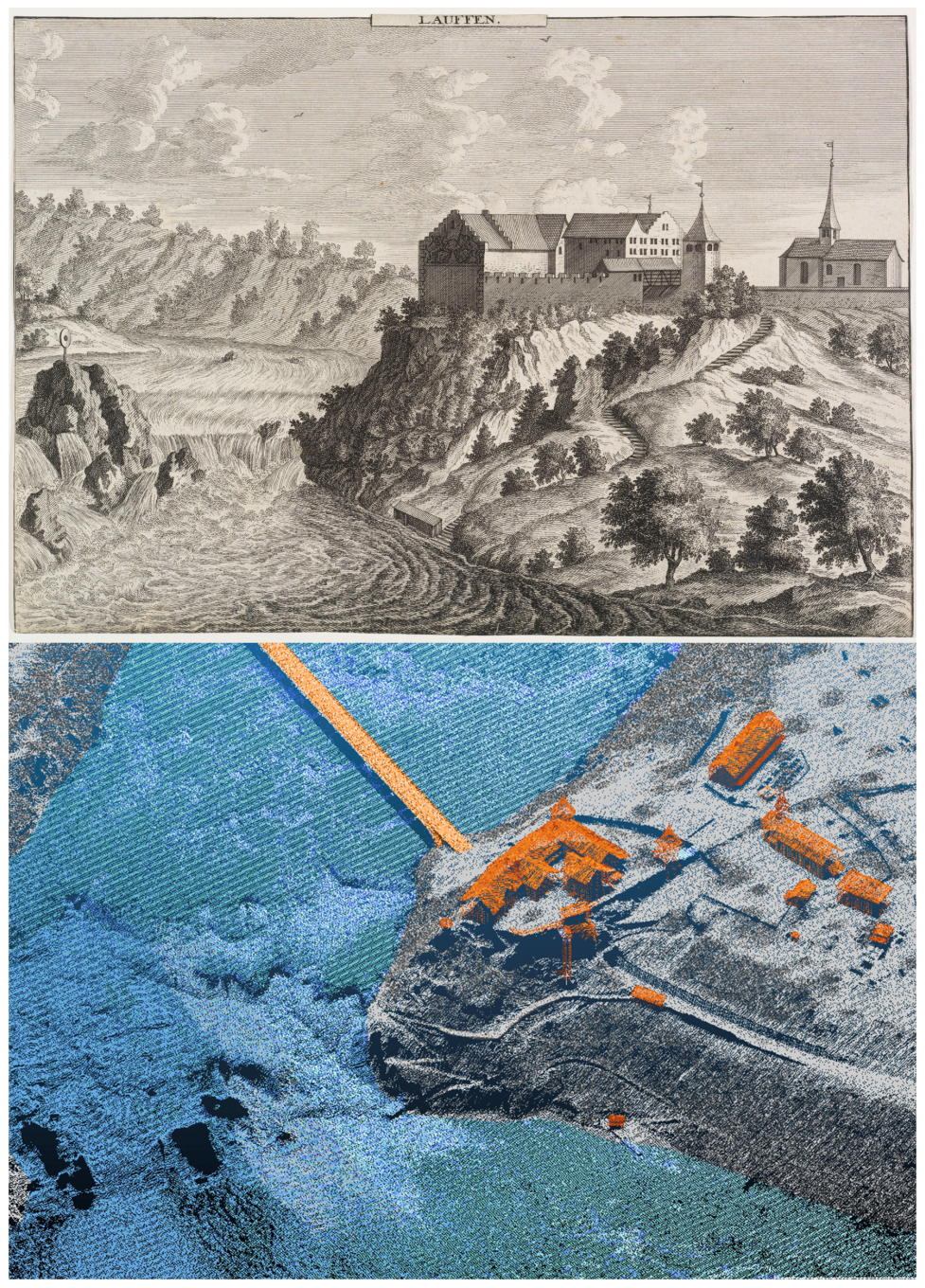
3.1. swissSURFACE3D Point Cloud
3.2. LiDAR-Derived swissSURFACE3D Raster
3.3. LiDAR-Derived swissALTI3D
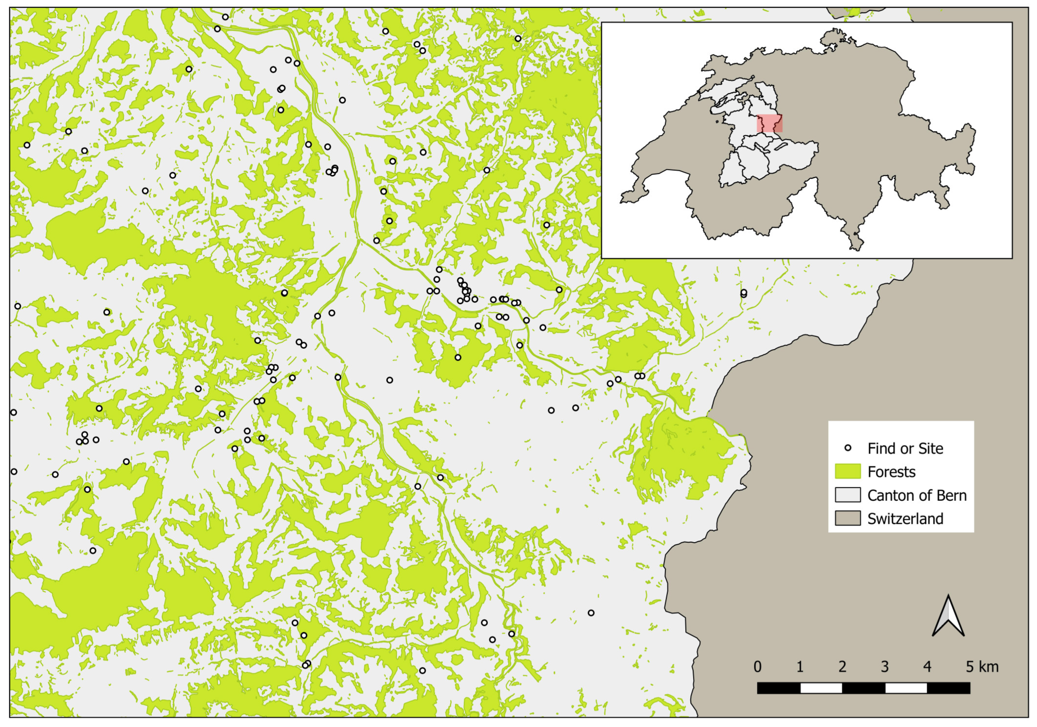
4. Surveying
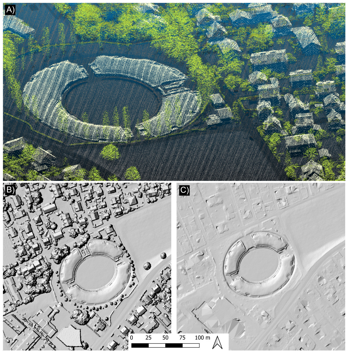
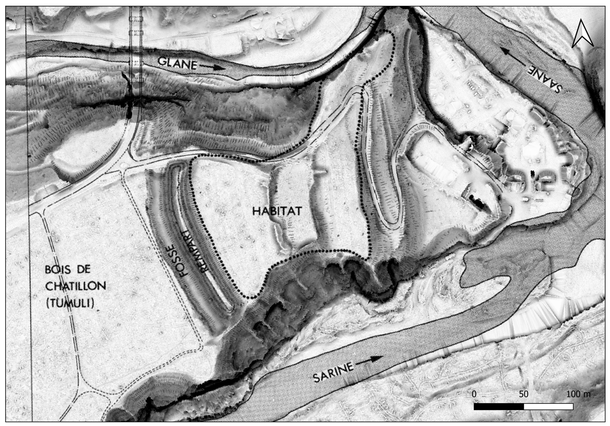
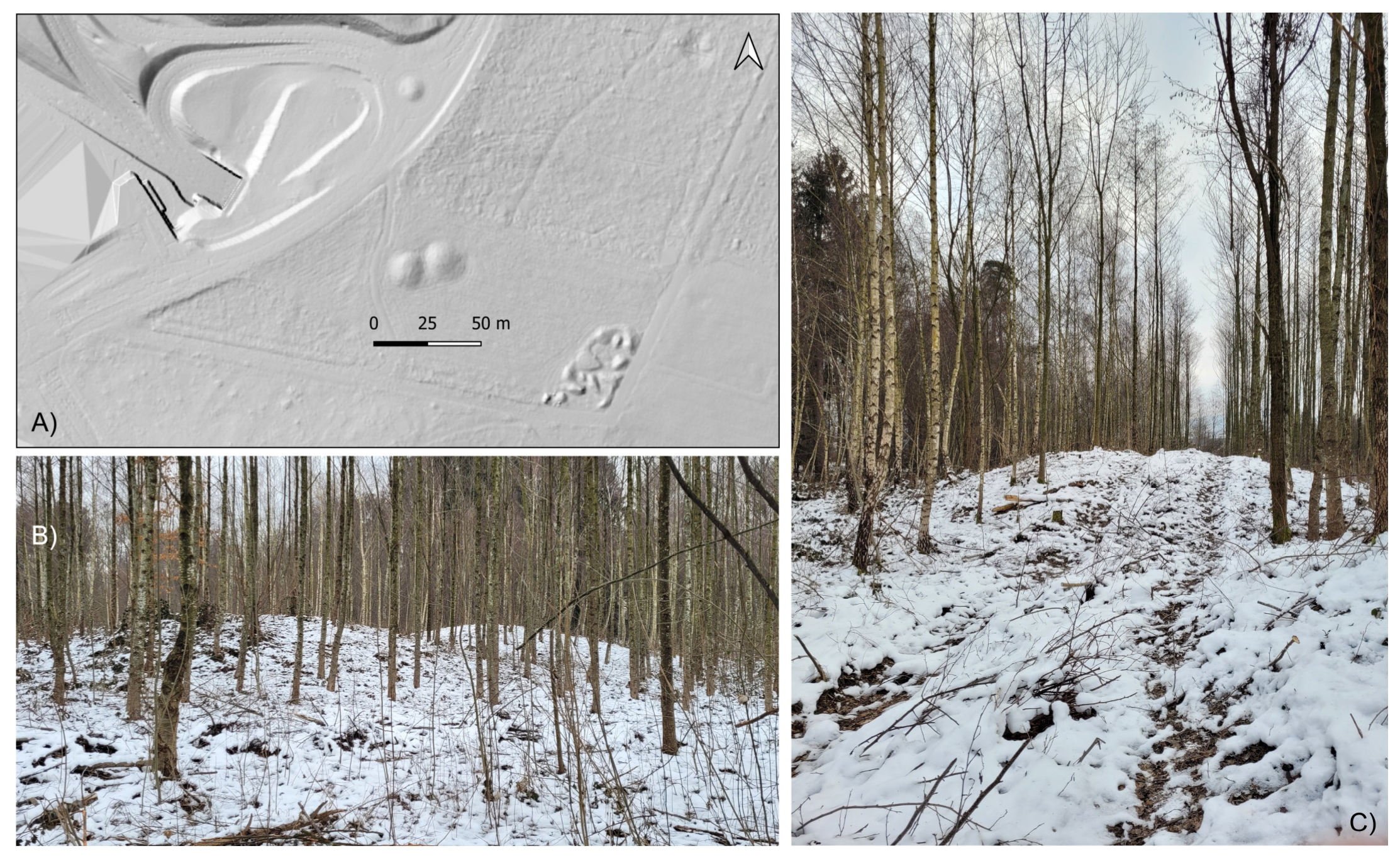
5. Re-Documentation
6. Monitoring and Protection
7. Visualization
8. The Potential of New LiDAR Datasets for Swiss Archaeology
Funding
Data Availability Statement
Acknowledgments
Conflicts of Interest
References
- Glennie, C.L.; Carter, W.E.; Shrestha, R.L.; Dietrich, W.E. Geodetic imaging with airborne LiDAR: The Earth’s surface revealed. Rep. Prog. Phys. 2013, 76, 086801. [Google Scholar] [CrossRef]
- Bewley, R.H.; Crutchley, S.P.; Shell, C.A. New light on an ancient landscape: Lidar survey in the Stonehenge World Heritage Site. Antiquity 2005, 79, 636–647. [Google Scholar] [CrossRef]
- Devereux, B.J.; Amable, G.S.; Crow, P. Visualisation of LiDAR terrain models for archaeological feature detection. Antiquity 2008, 82, 470–479. [Google Scholar] [CrossRef]
- Crutchley, S. Ancient and modern: Combining different remote sensing techniques to interpret historic landscapes. J. Cult. Herit. 2009, 10, e65–e71. [Google Scholar] [CrossRef]
- Kincey, M.; Challis, K. Monitoring fragile upland landscapes: The application of airborne lidar. J. Nat. Conserv. 2010, 18, 126–134. [Google Scholar] [CrossRef]
- Challis, K. Airborne laser altimetry in alluviated landscapes. Archaeol. Prospect. 2006, 13, 103–127. [Google Scholar] [CrossRef]
- Challis, K.; Kokalj, Z.; Kincey, M.; Moscrop, D.; Howard, A.J. Airborne lidar and historic environment records. Antiquity 2008, 82, 1055–1064. [Google Scholar] [CrossRef]
- Coluzzi, R.; Lanorte, A.; Lasaponara, R. On the LiDAR contribution for landscape archaeology and palaeoenvironmental studies: The case study of Bosco dell’Incoronata (Southern Italy). Adv. Geosci. 2010, 24, 125–132. [Google Scholar] [CrossRef] [Green Version]
- Cifani, G.; Opitz, R.; Stoddart, S. Mapping the Ager Faliscus road-system: The contribution of LiDAR (light detection and ranging) survey. J. Rom. Archaeol. 2007, 20, 165–176. [Google Scholar] [CrossRef]
- Rowlands, A.; Sarris, A. Detection of exposed and subsurface archaeological remains using multi-sensor remote sensing. J. Archaeol. Sci. 2007, 34, 795–803. [Google Scholar] [CrossRef]
- Chase, A.F.; Chase, D.Z.; Weishampel, J.F. Lasers in the Jungle. Archaeology 2010, 63, 27–29. [Google Scholar]
- Saturno, W.; Sever, T.L.; Irwin, D.E.; Howell, B.F.; Garrison, T.G. Putting us on the map: Remote sensing investigation of the ancient Maya landscape. In Remote Sensing in Archaeology; Springer: New York, NY, USA, 2007; pp. 137–160. [Google Scholar]
- Weishampel, J.F.; Chase, A.F.; Chase, D.Z.; Drake, J.B.; Shrestha, R.L.; Slatton, K.C.; Awe, J.J.; Hightowe, J.; Angelo, J. Remote sensing of ancient Maya land use features at Caracol, Belize related to tropical rainforest structure. In Space, Time, Place, Proceedings of the Third International Conference on Remote Sensing in Archaeology, Tiruchirappalli, India, 17–21 August 2009; Archeopress BAR: Oxford, UK, 2010; pp. 45–52. [Google Scholar]
- Hightower, J.N.; Butterfield, A.C.; Weishampel, J.F. Quantifying ancient Maya land use legacy effects on contemporary rainforest canopy structure. Remote Sens. 2014, 6, 10716–10732. [Google Scholar] [CrossRef]
- Iriarte, J.; Robinson, M.; de Souza, J.G.; Damasceno, A.; da Silva, F.; Nakahara, F.; Ranzi, A.; Aragao, L. Geometry by design: Contribution of lidar to the understanding of settlement patterns of the mound villages in SW Amazonia. J. Comput. Appl. Archaeol. 2020, 3, 151–169. [Google Scholar] [CrossRef]
- Evans, D.H.; Fletcher, R.J.; Pottier, C.; Chevance, J.B.; Soutif, D.; Tan, B.S.; Im, S.; Ea, D.; Tin, T.; Kim, S.; et al. Uncovering archaeological landscapes at Angkor using lidar. Proc. Natl. Acad. Sci. USA 2013, 110, 12595–12600. [Google Scholar] [CrossRef] [Green Version]
- Gallagher, J.M.; Josephs, R.L. Using LiDAR to detect cultural resources in a forested environment: An example from Isle Royale National Park, Michigan, USA. Archaeol. Prospect. 2008, 15, 187–206. [Google Scholar] [CrossRef]
- Johnson, K.M.; Ouimet, W.B. Rediscovering the lost archaeological landscape of southern New England using airborne light detection and ranging (LiDAR). J. Archaeol. Sci. 2014, 43, 9–20. [Google Scholar] [CrossRef]
- Thompson, A.D.R.; Finch, J. Reconstructing the layout of a coastal Georgia Plantation: Applications of LiDAR. J. Archaeol. Sci. Rep. 2023, 47, 103798. [Google Scholar]
- Sugiyama, N.; Sugiyama, S.; Catignani, T.; Chase, A.S.; Fernandez-Diaz, J.C. Humans as geomorphic agents: Lidar detection of the past, present and future of the Teotihuacan Valley, Mexico. PLoS ONE 2021, 16, e0257550. [Google Scholar] [CrossRef] [PubMed]
- Nagy, P.; Schwarz, P.A. Archäologische Prospektionen im Kanton Obwalden: Vorbericht zur Kampagne 2012. Jahrb. Archäologie Schweiz 2013, 96, 152–164. [Google Scholar]
- Reinhard, J.; Freund, D.; Meier, A. «Steinberge» im Flachwasser des nördlichen Zugerseeufers. Tugium 2020, 36, 89–100. [Google Scholar]
- Leuzinger, U.; Anselmetti, F.; Benguerel, S.; Degel, C.; Ehmann, H.; Gilliard, F.; Hipp, R.; Hornung, J.; Keiser, T.; Müller, E.; et al. «Hügeli» im Bodensee–rätselhafte Steinschüttungen in der Flachwasserzone zwischen Romanshorn und Altnau, Kanton Thurgau (Schweiz). Jahrb. Archäologie Schweiz 2021, 104, 101–116. [Google Scholar]
- Glanzmann, J. Neuentdeckte Holz-Erdburgen im Emmental, Kanton Bern (Schweiz): Ein Beitrag zu Prospektion und Burgenforschung. Burgen Und Schlösser 2019, 60, 194–204. [Google Scholar]
- Glanzmann, J. Auf Spurensuche im digitalen Geländemodell: Archäologische Funde im Wald dank Laservermessung aus der Luft. NIKE-Bulletin 2021, 36, 20–23. [Google Scholar]
- Lanzicher, A.F. Das Oppidum von Roggwil. Eine 2008 entdeckte keltische Stadt im Schweizer Mittelland. In Hefte zur Archäologie im Kanton Bern; Archäologischer Dienst des Kantons Bern: Bern, Switzerland, 2020; Volume 9. [Google Scholar]
- Caspari, G. Tracking the Cold: Remote Sensing for Glacial Archaeology. J. Glacial Archaeol. 2021, 5, 85–102. [Google Scholar] [CrossRef]
- Pilø, L.; Reitmaier, T.; Fischer, A.; Barrett, J.H.; Nesje, A. Ötzi, 30 years on: A reappraisal of the depositional and post-depositional history of the find. Holocene 2023, 33, 112–125. [Google Scholar] [CrossRef]
- BAFU Bundesamt für Umwelt (Ed.) 2021: Jahrbuch Wald und Holz 2021; Bundesamt für Umwelt: Bern, Switzerland, 2021. [Google Scholar]
- Johann, E. Wälder in den Alpen–Nutzung und Schutz. In Wald in der Vielfalt möglicher Perspektiven; Springer VS: Wiesbaden, Germany, 2022; pp. 201–221. [Google Scholar]
- Wieser, G.; Matyssek, R.; Luzian, R.; Zwerger, P.; Pindur, P.; Oberhuber, W.; Gruber, A. Effects of atmospheric and climate change at the timberline of the Central European Alps. Ann. For. Sci. 2009, 66, 402. [Google Scholar] [CrossRef] [PubMed] [Green Version]
- Dirnböck, T.; Dullinger, S.; Grabherr, G. A regional impact assessment of climate and land-use change on alpine vegetation. J. Biogeogr. 2003, 30, 401–417. [Google Scholar] [CrossRef]
- Ginzler, C.; Hobi, M.L. Countrywide stereo-image matching for updating digital surface models in the framework of the Swiss National Forest Inventory. Remote Sens. 2015, 7, 4343–4370. [Google Scholar] [CrossRef] [Green Version]
- Bundesam für Landestopografie Swisstopo. swissTLM3D. 2023. Available online: https://www.swisstopo.admin.ch/de/geodata/landscape/tlm3d.html (accessed on 20 February 2023).
- Bundesamt für Landestopografie Swisstopo. Beschaffung von LiDAR-Daten. 2023. Available online: https://www.swisstopo.admin.ch/de/wissen-fakten/geoinformation/lidar-daten.html (accessed on 19 February 2023).
- Bundesamt für Landestopografie Swisstopo. swissSURFACE3D-Die klassifizierte Punktwolke der Schweiz. 2021. Available online: https://www.swisstopo.admin.ch/content/swisstopo-internet/de/geodata/height/surface3d/_jcr_content/contentPar/tabs_copy/items/341_1554992541029/tabPar/downloadlist/downloadItems/275_1655731667941.download/swissSURFACE3D_Produktinfo_DE_20220601.pdf (accessed on 20 February 2023).
- ASPRS. LAS Specification Version 1.4-R13; The American Society for Photogrammetry & Remote Sensing: Bethesda, MD, USA, 2013. [Google Scholar]
- Yan, W.Y.; Shaker, A.; El-Ashmawy, N. Urban land cover classification using airborne LiDAR data: A review. Remote Sens. Environ. 2015, 158, 295–310. [Google Scholar] [CrossRef]
- Bundesamt für Landestopografie Swisstopo. swissSURFACE3D Raster-Das hoch aufgelöste Oberflächenmodell der Schweiz. 2021. Available online: https://www.swisstopo.admin.ch/content/swisstopo-internet/de/geodata/height/surface3d-raster/_jcr_content/contentPar/tabs_copy/items/dokumente/tabPar/downloadlist/downloadItems/35_1603804098168.download/Produktinfo_SS3DR_DE.pdf (accessed on 20 February 2023).
- Khosravipour, A.; Skidmore, A.K.; Isenburg, M. Generating spike-free digital surface models using LiDAR raw point clouds: A new approach for forestry applications. Int. J. Appl. Earth Obs. Geoinf. 2016, 52, 104–114. [Google Scholar] [CrossRef]
- Bundesamt für Landestopografie Swisstopo. swissALTI3D-Das Hoch Aufgelöste Terrainmodell der Schweiz. 2022. Available online: https://www.swisstopo.admin.ch/content/swisstopo-internet/de/geodata/height/alti3d/_jcr_content/contentPar/tabs_copy/items/dokumente/tabPar/downloadlist/downloadItems/846_1464690554132.download/swissALTI3D_detaillierte%20Produktinfo_DE_bf.pdf (accessed on 19 February 2023).
- Bundesamt für Landestopografie Swisstopo. swissALTI3D. 2023. Available online: https://www.swisstopo.admin.ch/de/geodata/height/alti3d.html#dokumente (accessed on 19 February 2023).
- Lambers, K.; Verschoof-van der Vaart, W.B.; Bourgeois, Q.P. Integrating remote sensing, machine learning, and citizen science in Dutch archaeological prospection. Remote Sens. 2019, 11, 794. [Google Scholar] [CrossRef] [Green Version]
- Caspari, G.; Crespo, P. Convolutional neural networks for archaeological site detection–Finding “princely” tombs. J. Archaeol. Sci. 2019, 110, 104998. [Google Scholar] [CrossRef]
- Trier, Ø.D.; Reksten, J.H.; Løseth, K. Automated mapping of cultural heritage in Norway from airborne lidar data using faster R-CNN. Int. J. Appl. Earth Obs. Geoinf. 2021, 95, 102241. [Google Scholar] [CrossRef]
- Lambers, K. Learning to look at LiDAR: The use of R-CNN in the automated detection of archaeological objects in LiDAR data from the Netherlands. J. Comput. Appl. Archaeol. 2019, 2, 31–40. [Google Scholar]
- Davis, D.S.; Caspari, G.; Lipo, C.P.; Sanger, M.C. Deep learning reveals extent of Archaic Native American shell-ring building practices. J. Archaeol. Sci. 2021, 132, 105433. [Google Scholar] [CrossRef]
- Fiorucci, M.; Verschoof-van der Vaart, W.B.; Soleni, P.; Le Saux, B.; Traviglia, A. Deep learning for archaeological object detection on LiDAR: New evaluation measures and insights. Remote Sens. 2022, 14, 1694. [Google Scholar] [CrossRef]
- Davis, D.S. Defining what we study: The contribution of machine automation in archaeological research. Digit. Appl. Archaeol. Cult. Herit. 2020, 18, e00152. [Google Scholar] [CrossRef]
- Ramseyer, D. Châtillon-sur-Glâne, Historisches Lexikon der Schweiz. 2005. Available online: https://hls-dhs-dss.ch/de/articles/012553/2005-07-14/ (accessed on 23 February 2023).
- Ramseyer, D. Châtillon-sur-Glâne (FR), un habitat de hauteur du Hallstatt final. Synthèse de huit années de fouilles (1974–1981). Jahrb. Der Schweiz. Ges. Für Ur-Und Frühgeschichte Basel 1983, 66, 161–188. [Google Scholar]
- Čučković, Z. QGIS Terrain Shading-Current Experimental Version: 0.9.4. 2022. Available online: https://github.com/zoran-cuckovic/QGIS-terrain-shading (accessed on 5 March 2023).
- Tapete, D.; Cigna, F. Detection of archaeological looting from space: Methods, achievements and challenges. Remote Sens. 2019, 11, 2389. [Google Scholar] [CrossRef] [Green Version]
- Caspari, G. Assessing looting from space: The destruction of Early Iron Age burials in northern Xinjiang. Heritage 2018, 1, 21. [Google Scholar] [CrossRef] [Green Version]
- Tapete, D.; Cigna, F.; Donoghue, D.N. ‘Looting marks’ in space-borne SAR imagery: Measuring rates of archaeological looting in Apamea (Syria) with TerraSAR-X Staring Spotlight. Remote Sens. Environ. 2016, 178, 42–58. [Google Scholar] [CrossRef] [Green Version]
- Caspari, G. Mapping and damage assessment of “royal” burial mounds in the Siberian Valley of the Kings. Remote Sens. 2020, 12, 773. [Google Scholar] [CrossRef] [Green Version]
- Schaer, A.; Alterauge, A.; Brechbühl, S.; Kissling, C. Die Bronzehand von Prêles (Kt. Bern/CH)–die älteste anthropomorphe Bronzeplastik Europas? Archäologisches Korresp. 2019, 49, 57–69. [Google Scholar]
- Powell, E.A.; Brown, M.; Weiss, D.; Pyne, L.; Lobell, J.A.; Urbanus, J. TOP 10 DISCOVERIES OF 2018. Archaeology 2019, 72, 26–33. [Google Scholar]
- Štular, B.; Kokalj, Ž.; Oštir, K.; Nuninger, L. Visualization of lidar-derived relief models for detection of archaeological features. J. Archaeol. Sci. 2012, 39, 3354–3360. [Google Scholar] [CrossRef]
- Challis, K.; Forlin, P.; Kincey, M. A generic toolkit for the visualization of archaeological features on airborne LiDAR elevation data. Archaeol. Prospect. 2011, 18, 279–289. [Google Scholar] [CrossRef]
- Thompson, A.E. Detecting classic Maya settlements with lidar-derived relief visualizations. Remote Sens. 2020, 12, 2838. [Google Scholar] [CrossRef]
- Inomata, T.; Pinzón, F.; Ranchos, J.L.; Haraguchi, T.; Nasu, H.; Fernandez-Diaz, J.C.; Aoyama, K.; Yonenobu, H. Archaeological application of airborne LiDAR with object-based vegetation classification and visualization techniques at the lowland Maya site of Ceibal, Guatemala. Remote Sens. 2017, 9, 563. [Google Scholar] [CrossRef] [Green Version]
- Guyot, A.; Lennon, M.; Hubert-Moy, L. Objective comparison of relief visualization techniques with deep CNN for archaeology. J. Archaeol. Sci. Rep. 2021, 38, 103027. [Google Scholar] [CrossRef]
- Masini, N.; Gizzi, F.T.; Biscione, M.; Fundone, V.; Sedile, M.; Sileo, M.; Pecci, A.; Lacovara, B.; Lasaponara, R. Medieval archaeology under the canopy with lidar. the (re) discovery of a medieval fortified settlement in southern Italy. Remote Sens. 2018, 10, 1598. [Google Scholar] [CrossRef] [Green Version]
- Fritz, S.; Fonte, C.C.; See, L. The role of citizen science in earth observation. Remote Sens. 2017, 9, 357. [Google Scholar] [CrossRef] [Green Version]
- Cohen, A.; Klassen, S.; Evans, D. Ethics in archaeological lidar. J. Comput. Appl. Archaeol. 2020, 3, 76–91. [Google Scholar] [CrossRef]
- Stewart, C.; Labrèche, G.; González, D.L. A pilot study on remote sensing and citizen science for archaeological prospection. Remote Sens. 2020, 12, 2795. [Google Scholar] [CrossRef]
- Lim, J.S.; Gleason, S.; Jones, W.; Church, W. Nuna Nalluyuituq (The Land Remembers): Remembering landscapes and refining methodologies through community-based remote sensing in the Yukon-Kuskokwim Delta, Southwest Alaska. Archaeol. Prospect. 2021, 28, 339–355. [Google Scholar] [CrossRef]


| Class | Type of Object | ASPRS Nomenclature |
|---|---|---|
| 1 | temporary or unclassified objects | unclassified |
| 2 | ground | ground |
| 3 | vegetation including low, medium, and high | low vegetation |
| 6 | buildings | buildings |
| 9 | water | water |
| 17 | bridges, overpasses, and viaducts | bridge deck |
Disclaimer/Publisher’s Note: The statements, opinions and data contained in all publications are solely those of the individual author(s) and contributor(s) and not of MDPI and/or the editor(s). MDPI and/or the editor(s) disclaim responsibility for any injury to people or property resulting from any ideas, methods, instructions or products referred to in the content. |
© 2023 by the author. Licensee MDPI, Basel, Switzerland. This article is an open access article distributed under the terms and conditions of the Creative Commons Attribution (CC BY) license (https://creativecommons.org/licenses/by/4.0/).
Share and Cite
Caspari, G. The Potential of New LiDAR Datasets for Archaeology in Switzerland. Remote Sens. 2023, 15, 1569. https://doi.org/10.3390/rs15061569
Caspari G. The Potential of New LiDAR Datasets for Archaeology in Switzerland. Remote Sensing. 2023; 15(6):1569. https://doi.org/10.3390/rs15061569
Chicago/Turabian StyleCaspari, Gino. 2023. "The Potential of New LiDAR Datasets for Archaeology in Switzerland" Remote Sensing 15, no. 6: 1569. https://doi.org/10.3390/rs15061569
APA StyleCaspari, G. (2023). The Potential of New LiDAR Datasets for Archaeology in Switzerland. Remote Sensing, 15(6), 1569. https://doi.org/10.3390/rs15061569