Article

Joint Estimation of Ground Displacement and Atmospheric Model Parameters in Ground-Based Radar

School of Geosciences and Info-Physics, Central South University, Changsha 410083, China
*
Author to whom correspondence should be addressed.
Remote Sens. 2023, 15(7), 1765; https://doi.org/10.3390/rs15071765
Submission received: 7 March 2023 / Revised: 20 March 2023 / Accepted: 23 March 2023 / Published: 25 March 2023

Abstract

:
Atmospheric delay is the primary error in ground-based synthetic aperture radar (GBSAR). The existing compensation methods include the external meteorological data correction method, the polynomial fitting method, and the persistent scatterers SAR interferometry (PSInSAR) calibration method. Combining the polynomial fitting and the persistent scatterers targets is the most popular method of GBSAR atmospheric delay compensation. However, the displacement component of the coherent target is always ignored in the atmospheric delay compensation, which is unpractical. A joint estimation method of ground displacement and atmospheric model parameters is developed in this paper. The displacement component is determined by the spatial and temporal features of the objects. The atmospheric delay component is regarded as a systematic error represented by a quadratic polynomial related to distance. The result is resolved by the least-square method. Compared to the existing method, the root-mean-square error (RMSE) of the proposed method had a significant improvement in the validation experiment. In the real in situ experiment, the time series obtained by the GBSAR had a similar trend to that acquired by the Global Positioning System (GPS) receiver. It is indicated that the proposed method can lead to a better deformation estimation by taking the deformation component into account in the atmospheric compensation.

Graphical Abstract

1. Introduction

GBSAR has been applied to monitor the deformation in various scenarios, including dams [1], bridges [2], and slopes [3,4]. The atmospheric delay is composed of tropospheric delay and ionospheric delay in the process of spaceborne interferometry SAR [5]. The spatial–temporal variation feature of tropospheric delay is the biggest challenge in spaceborne InSAR. Atmospheric delay is an important factor affecting GBSAR deformation monitoring, as with spaceborne SAR [6]. Up to now, there are primarily three methods for the atmospheric delay phase compensation: the correction method by external meteorological data [7], the polynomial fitting method [8,9,10], and the correction method by time-series InSAR [11,12].
The observation instrument and the targets are located under the troposphere, which is the reason that the atmospheric delay contains only tropospheric delay in the ground-based InSAR. The correction method by external meteorological data is the most direct. However, there are unavoidable observation errors in external meteorological data. The sampling frequency of GBSAR is often inconsistent with the sampling frequency of meteorological data. Also, it is difficult to install meteorological observation instruments in the observation area. Therefore, the correction result by this method has uncertainty.
The polynomial fitting method is a common method. Under the assumption of spatial homogeneity for the atmosphere in the small scenarios, the atmospheric phase screen is fitted by a polynomial function. A function of the tropospheric delay phase is established for the interferometric phase on the stable point targets, and the atmospheric parameters are obtained by polynomial fitting. Compared to the correction method by external meteorological data, this method prevents the correction results from external errors and reduces uncertainty.
The correction method by time-series InSAR builds the relationship between the time-series interferometric phase and deformation phase, and obtains the linear deformation velocity by the least-square (LS) method. Then, the non-linear deformation contribution and the atmospheric phase contribution are separated from the residual phase by filtering, based on their different inherent spatio-temporal features in the frequency domain. The external meteorological data are unnecessary for this method. It depends on practical experience to choose the filtering algorithm and determine the window size, and it is assumed that the magnitude of deformation is significantly greater than that of atmospheric delay. This is inappropriate for high-frequency deformation monitoring by GBSAR.
So far, it is popular to compensate for the atmospheric delay phase by combining the polynomial fitting method and the correction method by time-series InSAR, which breaks through the limitation of external meteorological data and reduces the practical experiences. Most of the existing research assumes that the coherent point targets hold still and the interferometric phase consists of only atmospheric delay, which is not rigorous. To overcome this shortcoming, a joint estimation method of ground displacement and atmospheric model parameters is proposed in this paper. In Section 2, the joint estimation method is described in detail. This method establishes the function model and stomatic model between the interferometric phase and the deformation phase and atmospheric model parameters, and obtains the parameters by the LS method. In Section 3, the proposed method is validated. The estimation results of the proposed method are compared with other methods. The proposed method is applied to an in situ experiment on the Sanchaji Bridge in Changsha in Section 4. In Section 5, the necessity of the additional systematic parameters is discussed. The results obtained by different methods in the first experiment are compared and discussed, and the time series acquired by GBSAR and the GPS are also compared. Finally, the conclusion is presented in Section 6.

2. Method Development for Joint Estimation of Ground Displacement and Atmospheric Model Parameters

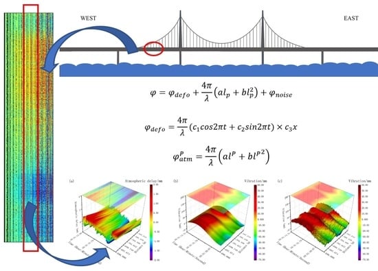
2.1. Phase Model of Ground-Based Radar

GBSAR has three scanning modes: linear scanning mode, arc scanning mode, and rotation scanning mode [6]. The equipment obtains two acquisitions, φ 1 and φ 2 , respectively at the moment t 1 and t 2 for a target on the ground. The single acquisition consists of the contributions of the geometric distance phase and the scattering phase [13]:
φ 1 = 2 2 π λ R + φ s c a t t 1
φ 2 = 2 2 π λ R + Δ R + φ s c a t t 2
where R is the geometric distance between the GBSAR and the target, Δ R is the path difference during the acquisitions, and φ s c a t t 1 and φ s c a t t 2 are the contributions of the scattering phase. It is necessary to co-register the master and the slave images before interferometry because of the different incident angles during the two acquisitions. In this paper, we fix the scanning angle to monitor an area continuously, so it is unnecessary to do co-registration. The interferometric phase is expressed as:
φ = 4 π λ Δ R + φ s c a t t 1 φ s c a t t 2 + 2 n · π n = 0 , ± 1 , ± 2
where n is the integer ambiguity.
The path difference results from the atmospheric delay, the displacement in the line-of-sight (LOS) direction, the geometric phase error, and the noise. Because of the fixed scanning angle, the geometric phase error can be ignored in this paper. Here, the interferometric phase is expressed as:
φ = φ d e f o + φ a t m , 2 φ a t m , 1 + φ n o i s e + 2 n · π
where φ d e f o is the deformation phase during the different acquisitions in the LOS direction, φ a t m , 2 φ a t m , 1 is the difference between the atmospheric delay phases, and φ n o i s e is the noise phase composed of different scattering phases and noise contribution and the integer phase.

2.2. Atmospheric Phase Modeling for Ground-Based Radar

The propagation of microwaves in the atmosphere will be affected by the refraction of the atmosphere. Its speed is slower than that in the vacuum due to the index of refraction. The index of refraction is defined as n = c 0 / c , where c 0 is the speed of the electromagnetic wave in a vacuum and c is the speed in the atmosphere. The relation between the refractivity index N and the index of refraction n is expressed as:
N = n 1 × 10 6
The atmospheric refractive index is a million times the difference between the index of refraction and 1. The observation instrument and the targets are located under the troposphere. The refractivity index in the troposphere is a function of temperature T (in Kelvin), relative humidity H (in percentage), and pressure P (in millibars). The atmospheric delay is composed of contributions of atmospheric dry delay and wet delay, which is expressed as [14,15]:
N = N T , H , P = N d r y + N w e t = 77.6 T p d + 77.6 + 3.73 × 10 5 T e T
where p d is the partial pressure of dry gases (in millibars), e is the partial pressure of water vapor in millibars, and the relation between them is P = p d + e . The partial pressure of water vapor is the product of relative humidity H and standard saturation vapor pressure e s . There are many methods to calculate standard saturation vapor pressure, and the Magnus-Tetens function [16] is applied here:
e = H e s = H · 6.11 e x p 17.27 T 237.16 T 35.86
There are two meteorological devices installed at the approximate height on the ground. Two data sets are acquired respectively from 0:00 h on 28 September 2022 to 14:40 h on 29 September 2022, and from 0:00 h on 15 October 2022 to 13:56 h on 16 October 2022. The dry and wet components of the refractivity index are shown in Figure 1 and Figure 2. It is obvious that the magnitude of N d r y is greater than that of N w e t . N d r y fluctuates more gently than N w e t in the time domain. It is assumed that N is more sensitive to N w e t .
The atmospheric phase contribution at one acquisition is the function of the refractivity index:
φ a t m , p t = 10 6 · 4 π λ 0 L N T , H , P d l
where L is the distance between the GBSAR and the target.
It is demonstrated that the atmospheric phase has spatial homogeneity at a short distance and in a small area [1], so the atmosphere has a similar impact on the targets at the same distance. Therefore, (8) is adapted to:
φ a t m , p t = 10 6 · 4 π λ · l p · N ( t )
The atmospheric delay component in the interferometric phase between time t 1 and t 2 on the target P at the distance l p is expressed as:
φ a t m , p t 1 , t 2 = φ a t m , p t 2 φ a t m , p t 1 = 10 6 · 4 π λ · l p · N t 2 N t 1 = 10 6 · 4 π λ · l p · Δ N
The atmospheric refractivity index is in inverse proportion to height. Usually, the horizontal variations of N can be neglected, and the troposphere can be regarded as a quasi-homogeneous spherically layered medium [17]. Therefore, the primary variation of N is vertical, and N increases as the height is decreased, which means that the tropospheric delay is greater near the ground surface. The tropospheric-delay relationship can be modeled using an exponential function [18] as:
N = N S e x p h H
where N S is the average value of refractivity at the Earth’s surface, H is the height scale of the standard atmosphere, and h is the height above the Earth’s surface. For convenience, the refractivity index can be approximated by the first two terms of the Taylor series at h = 0 :
N = a 0 + a 1 h
We can replace the refractivity index N in Equation (10) with Equation (12); h is the height difference between the GBSAR and a target. The relationship between the distance l in the LOS direction and the height difference h can be expressed as h = l sin θ , where θ is the angle between the LOS and the horizontal line:
φ a t m , p t = 10 6 · 4 π λ 0 L a 0 t + a 1 t h d l = 10 6 · 4 π λ 0 L a 0 t + a 1 t l sin θ d l = 10 6 · 4 π λ · a 0 t · l + 1 2 a 1 t sin θ l 2
Let
a = 10 6 · a 0 t
b = 10 6 · 1 2 a 1 t sin θ
The observation phase consists of the deformation phase, atmospheric delay phase, and noise:
φ = φ d e f o + 4 π λ a l p + b l p 2 + φ n o i s e

2.3. Function and Stochastic Model for Joint Estimation of Displacement and Atmosphere

On the assumption of atmospheric spatial homogeneity at a short distance and in a small area, the function and stochastic mode for joint estimation of displacement and atmospheric parameters on the coherent targets are established.
Using the dispersion index to select permanent scatterers, which was proposed by Ferretti [19], is one of the most popular methods up to now. The dispersion index D A is a measure of phase stability:
D A = σ A μ A
where μ A and σ A are the mean and the standard deviation of the amplitude. Small values of D A are good estimates of the phase dispersion, which means that there is a domain scatterer in the pixel.
Generally, the deformation of a target is a function of time:
φ d e f o = f t | a r
where t is the acquisition moment, and a r ( r = 1,2 , 3 , τ ) stands for τ coefficients in the deformation model. In this paper, the periodic model is selected to simulate the deformation phase:
φ d e f o = 4 π λ ( c 1 c o s 2 π t + c 2 s i n 2 π t )
where c 1 and c 2 are the coefficients. The function can be expressed in the matrix form, φ d e f o = q v , where q is the coefficient vector, and v represents the unknown parameters:
q = [ c o s 2 π t , s i n 2 π t ]
v = [ c 1 , c 2 ] T
For the kth interferogram, its master and slave images are acquired at t m and t s . The deformation phase at the point P can be derived as:
φ d e f o , k P = 4 π λ q m q s v P
Atmospheric delay is spatially homogeneous but independent at every acquisition. The atmospheric phase can be regarded as a systematical error in the time series. Therefore, the atmospheric phase at one acquisition can be expressed as a quadratic polynomial:
φ a t m P = 4 π λ a l P + b l P 2
Let
m = [ l P , l P 2 ]
r = a , b T
where m is the coefficient matrix, and r is the unknown polynomial parameter matrix. Then, Equation (23) is adapted to:
φ a t m P = 4 π λ m P r
The atmospheric delay difference Δ φ a t m , k P at the target P can be derived as:
Δ φ a t m , k P = 4 π λ m P r m r s
There are S PS targets in the scenario, p 1 , p 2 , , p S with the distance l 1 , l 2 , , l S from the GBSAR, and Q acquisitions are captured. The triangulation network is recommended to combine the acquisitions to obtain M interferometric phase, which coubld be referred to Appendix A. The phase connects to the subsequent two phases in chronological order just like Figure A1. Then, M × S observation equations are derived for all the targets:
Φ = A X + B Y + ε
where Φ is the interferometric phase vector; A is the coefficient matrix for the unknown parameters vector of the deformation model; X is the unknown parameters vector including v ; B is the coefficient matrix of the additional systematic parameters vector; Y is the unknown additional systematic parameters vector including r ; ε is the noise vector consisting of different scattering phases and noise contributions.
The stochastic model is expressed as:
D = σ 0 2 P 1
where D is the covariance matrix, σ 0 2 is the variance of unit weight, and P is the weight matrix of the observations which is derived from the coherence value generally. The variance of unit weight is expressed as:
σ 0 2 = V T P V n t
where V is the error vector, which is the difference between the observed interferometric phase vector and the estimated interferometric phase vector. V is derived from:
V = Φ A X ^ + B Y ^

2.4. Joint Estimation of Ground Displacement and Atmospheric Model Parameters

According to the principle of LS, we get:
A T P A A T P B B T P A B T P B X ^ Y ^ = A T P f B T P f
where
f = A X 0 + B Y 0 Φ
In general, the approximate value of X 0 and Y 0 can be set as a zero vector.
Let N X X = A T P A , N X Y = A T P B , N Y X = B T P A , N Y Y = B T P B , = N Y Y N Y X N X X 1 N X Y , then we get the solution:
X ^ Y ^ = N X X 1 + N X X 1 N X Y J 1 N Y X N X X 1 N X X 1 N X Y J 1 J 1 N Y X N X X 1 J 1 A T P f B T P f
So far, the estimation of displacement and atmospheric model parameters can be realized.
It should be noted that the weight matrix of the observations P can be determined by the coherence, and the coherence value γ ^ can be derived by:
γ ^ = i = 1 j Z i , m Z i , s * i = 1 j Z i , m i = 1 j Z i , s
where Z i , m and Z i , s are the complex values of two different SAR images at the ith pixel, * stands for complex conjugate multiplication, and j is the window size to estimate the coherence.

3. Validation of the Developed Method

To validate the above algorithm, an in situ experiment was implemented near a hill behind the Zhongda Group in the Yuelu District in Changsha, China. Four corner reflectors were installed in the scenario. As Figure 3 shows, two of them were installed on the top of an office building, and the others were installed on the hill. At the same time, a meteorological device was installed on the office building and another one was installed around the corner reflectors on the hill, which collected meteorological data, including temperature, pressure, and relative humidity.
The ground-based radar is a real aperture radar that was developed by the Zhongda Group. The data set was collected between 18:09:01 h on 15 October and 14:21:17 h on 16 October. We collected a frame once in 0.108 s and acquired 432,284 frames in total. The bandwidth was 600 Hz, the sampling rate was 24.3 GHz, and the wavelength was 12.3 mm. The distances were respectively 62.19 m, 69.00 m, 328.79 m, and 358.52 m for the four reflectors P1, P2, P3, and P4. The temperature at the top of the building and on the slope was different. Therefore, the four reflectors were separated at different sites and different distances.
The atmospheric delay time series of the four reflectors are shown in Figure 4 based on the collected meteorological data. The first meteorological device provided data for P1 and P2, and the collecting time covered that of the radar. The second device provided data for P3 and P4, but the collecting time did not cover that of the radar completely.
The proposed algorithm was applied to the time series data of the four reflectors acquired by the ground-based radar. The results are shown in Figure 5, where the blue line is the original observed displacement data, the red line is the atmospheric delay, the yellow line is the displacement fitting line, and the dark line represents the difference value between the original observed displacement data and the atmospheric delay. The mean value, standard deviation (SD), and the RMSE of every time series of the four reflectors are shown in Table 1.

4. Application of the Developed Method for Monitoring Bridge Displacement

Another experimental observation of the long-span Sanchaji Bridge, which is located in northern Changsha and connects the Yuelu District with the Kaifu District, was implemented. In this experiment, the GAMMA Portable Radar Interferometer II (GPRI-II), which was developed by GAMMA Remote Sensing and Consulting AG, was deployed under the bridge on its western upstream sides at a sampling frequency of 2000 Hz. To validate the monitoring capability of GPRI-II, a GPS receiver developed by Trimble Inc at a sampling frequency of 50 Hz was mounted on the balustrade to observe the vibration of the bridge synchronously. The real-time kinematic (RTK) solution mode was applied to monitor the vibration. The basic parameters of the GPRI-II are shown in Table 2.
The data were collected in the fixed scanning mode without angular rotation. The data at every sample were called a frame and recorded in a row in Figure 6c, and the time series of every pixel was arranged in a column. The interferometric phase starting at 10:31:07 h and lasting 45 s are shown in Figure 6c. As illustrated in Figure 7, the Sanchaji Bridge is a suspension bridge. The GPS receiver was installed in the middle of the bridge, and the GPRI-II was placed on the west bank.
According to geometry, the 935th pixel from left to right in the frame was linked to the GPS receiver in space. We employed the data recorded by the GPS receiver installed on the top of GPRI-II, as well as the distance of every pixel recorded by the GBSAR, and measured the vertical height between the bridge and the GBSAR. Then, the geographic coordinates of every pixel in the images can be solved. The pixels around it, whose index was 926, 927, 928, 929, 930, 931, 933, 934, 936, 939, 940, 941, 942, 943, were selected as the permanent scatterers with D A less than 0.25. The function model was established for these point targets. These 15 pixels join together with each other to form a segment of the bridge in space. Unlike the prior experiment, the deformation model was updated considering the spatial feature of displacement:
φ d e f o = 4 π λ ( c 1 c o s 2 π t + c 2 s i n 2 π t ) × c 3 x
where x is the coordinate in space.
The solution at the 935th pixel is shown in Figure 8, where the blue line represents the observed vibration of the bridge, the red line represents the atmospheric delay, the yellow line represents the vibration fitting line, and the dark line represents the difference value between the original observed displacement data and the atmospheric delay. It is noted that the vibration is transformed from the LOS to the vertical direction.
The vibration of the 15 pixels acquired by the GBSAR is shown in Figure 9. As in Figure 8, the vibration is the difference between the observed data and the estimated atmospheric delay. Because the range spacing is 0.75 m, the 15 pixels are spread at the corresponding distances. The amplitude of the vibration time series ranged from −60 mm to 20 mm relative to the starting time. There were some pixels masked among the samples because of their high D A values. However, from Figure 9, we can see this segment of the bridge had a feature from up to down in general during observation time.

5. Discussion

5.1. Significance of Incorporating the System Parameters

The atmospheric component in the function model is regarded as a systematic error. A quadratic polynomial with two coefficients describes the atmospheric delay. The two coefficients are called systematic parameters in the function model and are solved by the LS method. The additional system parameters change the original model, i.e., Φ = A X + ε . Therefore, we need to consider whether these additional parameters are necessary or not. Here, it is necessary to do significance testing for the systematic parameters. If the testing result is significant, the parameters should be reserved.
The null and alternate hypotheses are stated: H 0 : Y ^ = 0 , H 1 : Y ^ 0 ; the F test statistic formula is given below:
F = Y ^ T J 1 Y ^ m V T P V n t = Y ^ T J 1 Y ^ δ ^ 0 2 m ~ F m , n t
where Y ^ is the solved value of the system parameters vector, J is the variance–covariance matrix of the system parameters vector, V is the error vector that is the difference between the observed value and the estimated value, P is the weighting matrix of the observed vector that is expressed by the coherence of the master and the slave images, δ ^ 0 2 is the variance of unit weight, m is the first degree of freedom, n t is the second degree of freedom, m is the rank of B , n is the number of the observed values, and t is the number of systematic parameters.
Given a significance level α , if
F > F 1 α m , n t
the null hypothesis is rejected.
As for the first experiment, at the significance level α = 0.05 , the first degree of freedom is 4324, and the second degree of freedom is 17,276, then F 0.95 4324 , 17276 = 1.0401 . F = 4.9550 > 1.0401 . Therefore, the null hypothesis is rejected, and the alternate is accepted.
For the second experiment, at the significance level α = 0.05 , the first degree of freedom is 4500, the second degree of freedom is 67,425, and F 0.95 4500 , 67425 = 1.0361 . F = 3.0990 > 1.0361 . Thus, the null hypothesis is rejected, and the alternate is accepted.
Therefore, we believe that the system parameters should be considered in the function model. It is indicated that the original function model which only contains the unknown deformation parameters is inappropriate.
On the other hand, according to the meteorological data, the atmospheric disturbance caused a measuring error of approximately 10 mm about 330 m away in Figure 4. We can see that the humidity presents the strongest fluctuations in one day compared to the pressure and the temperature in Figure 10, and the humidity is the primary reason for the atmospheric disturbance which results in the variation of the refractive index. This is the practical reason for the additional systematic parameters in the function model.

5.2. Comparisons of Atmospheric Delay Calculated by Different Methods

The atmospheric delay was calculated by the meteorological data, polynomial fitting, and the proposed methods. Before the comparison, the atmospheric delay calculated based on the meteorological data was interpolated because of its lower sampling rate. As with the polynomial fitting method, the nearest and the farthest reflectors were chosen as the stable reference points. The four reflectors P1, P2, P3, and P4 are located at distances of 65.19, 69.00, 328.79, and 358.52 m.
The time series obtained by the meteorological data are shown in Figure 11. The red line represents the atmospheric delay. We can see that the atmospheric delay is proportional to the range distance. As mentioned before, the wet partial component of tropospheric delay is the primary component. Therefore, the atmospheric delay climbed to the summit in the morning. We can see that the displacement after the atmospheric compensation of P1 and P2 is smaller than that of P3 and P4, as with the observed displacement. Because the reflectors stood still during the observation, the displacement of the targets should have been zero or around zero in a tiny interval. It seems that the external meteorological data cannot satisfy the accuracy requirements.
The result obtained by the polynomial fitting method is shown in Figure 12. A quadratic polynomial relative to distance, Equation (23), is employed based on the spatial homogeneity of the atmosphere in a small area. The reflectors P1 and P4 were selected as the reference points. We can see that the atmospheric delay is fitted well for P2 and P3. The displacement in Figure 12 is similar to the difference value between the original observed displacement data and the atmospheric delay in Figure 5. However, the time series around the end of the observation is more stable by the proposed method.
We compared the difference value between the original observed displacement data and the atmospheric delay by the proposed method with the displacement obtained after the atmospheric compensation by the external meteorological data correction method and polynomial fitting method. The mean and SD were calculated to evaluate the precision of the estimation of displacement. The RMSE between them and the zero array was also calculated. The zero array was regarded as the actual value because the reflectors were stable.
The comparison results are shown in Table 3. The reflectors P1 and P4 were selected as the reference points; therefore, the SD and RMSE obtained by the polynomial fitting method are zero. We can see that the SD and RMSE for all points by the proposed method are significantly improved compared to those of the other two methods.
For reflector P1, the SD and RMSE by the proposed method are respectively improved by 60.00% and 58.75% compared to that by the external meteorological data correction method.
For reflector P2, the SD and RMSE by the proposed method are respectively improved by 50.00% and 42.86% compared to that by the external meteorological data correction method. The SD and RMSE by the proposed method are respectively improved by 33.33% and 32.41% compared to that by the polynomial fitting method.
For reflector P3, the SD and RMSE by the proposed method are respectively improved by 80.00% and 71.03% compared to that by the external meteorological data correction method. The SD and RMSE by the proposed method are respectively improved by 57.14% and 51.02% compared to that by the polynomial fitting method.
For reflector P4, the SD and RMSE by the proposed method are respectively improved by 82.91% and 83.54% compared to that by the external meteorological data correction method.

5.3. Comparisons between the Vibration Time Series Acquired by the GPS and GBSAR

In the real in situ experiment, we applied the proposed method to the time series acquired by GBSAR. A set of pixels around the GPS receiver are selected to resolve the function model. The solution at the 935th pixel is shown in Figure 13. In the time domain, the displacement fitting line shows the periodic feature of the bridge vibration.
The difference value of the observed data and the atmospheric delay is shown in Figure 13 with the comparison with the time series acquired by the GPS receiver. The sampling frequency of GBSAR is 200 Hz, and the sampling frequency of GPS is 50 Hz. Therefore, the GBSAR result was sampled every four frames. The RMSE of the time series relative to that acquired by GPS is 12.19 mm. From the results, we can see that they have a familiar trend from up to down relative to the first time stamp. The vibration results from the coupling of various excitation of the cars, trucks, and wind. The excitation of the trucks is the primary reason for the trend in Figure 13. However, there are two differences at the beginning and end of the curves between the two time series in Figure 13. It is thought that the position-matching error is the primary reason. We used the position data acquired from the GPS receiver set on the top of GPRI-II, and the range measured by the antenna to locate the pixel corresponding to the GPS receiver on the bridge. It was unavoidable that the positioning and ranging were affected during the observation. Moreover, the GPS receiver was mounted on the balustrade, but the bottom of the bridge was actually observed. The structure and the components of the bridge are too complicated to be regarded as a rigid body in this comparison. Therefore, corner reflectors are recommended when jointly monitoring the vibration of a bridge by GPS and GBSAR. The reflectors improve the visual quality of targets in the SAR image, enhancing the difference or feature of the target object.
The vibration of a segment of the bridge around the 935th pixel is shown in Figure 14. A set of pixels were collected to jointly estimate the vibration and atmospheric model parameters. After interpolation in space, we modeled the temporal and spatial variation of a segment of the bridge about 10 m (the range resolution of GPRI-II is 0.75 m). The atmospheric delay in the LOS direction, vibration fitting result, and the difference between the observed data and the atmospheric delay are shown in sequence.
The atmospheric delay was chaotic in the time domain but consecutive in space. The patterns of atmospheric delay of every unit were different, but they had a common feature of up-to-down. Compared to the vibration fitting, the atmospheric delay was a smaller partial component of the observed data, but it changed rapidly. As we stated before, a displacement model considering the spatial and temporal features was applied. Although the vibration magnitude was different for every unit in the space, we can see that this segment of the bridge had a unified variation. The difference between the observed data and the atmospheric delay reserved more details. It was assumed that the load was the main reason for the vibration and the wind vibration was the secondary reason.

6. Conclusions

A method of joint estimation of ground displacement and atmospheric model parameters for GBSAR is proposed in the paper. This method has better precision compared to the external meteorological data correction method, and is operated more flexibly than the polynomial fitting method. This method considers both the spatial and temporal features of the displacement and the spatial feature of the atmospheric delay. We implemented a validation experiment to prove the capacity of joint estimation of the proposed method for stable artificial targets. We also applied the developed method to monitor the vibration of a bridge along the GPS receiver. These results show that:
(1)
Additional systematic parameters are necessary for the functional model according to the hypothesis testing and the practical test. It is indicated that the original function model which only contains the unknown deformation parameters is inappropriate.
(2)
The proposed method is a significant improvement compared to the external meteorological data correction method and the polynomial fitting method. The external meteorological data correction method is the worst among the three methods.
(3)
The proposed method can split the atmospheric delay and displacement, and enhance the capacity of the monitoring bridge with the GBSAR device. It is suggested that reflectors are recommended when the device is employed to monitor the vibration of structures. An appropriate displacement model should be selected based on the displacement features of the structures.

Author Contributions

Conceptualization, B.X. and Y.Z.; methodology, Y.Z.; software, Y.Z. and J.L.; writing—original draft preparation, Y.Z.; writing—review and editing, J.H. and W.M.; funding acquisition, Z.L. All authors have read and agreed to the published version of the manuscript.

Funding

The research was partly funded by the National Science Fund for Distinguished Young Scholars, grant number No. 41925016, and the Fundamental Research Funds for the Central Universities of Central South University, grant number No. 2020zzts191.

Data Availability Statement

The data is not publicly available due to privacy.

Acknowledgments

The authors would like to thank Zhongda Group for the support of the GBSAR data and the meteorological data.

Conflicts of Interest

The authors declare no conflict of interest.

Appendix A

Given that there are N images in chronological order, let the single-look complex (SLC) phase be ϕ 1 , ϕ 2 , ϕ N at time t 1 , t 2 , t N . We can get M interferometric pairs Δ ϕ 1 , Δ ϕ 2 , Δ ϕ M , and the number of interferometric pairs M satisfies the inequality (we have implicitly assumed that N is odd):
N + 1 2 M N N + 1 2
As for the triangulation network, every frame will connect to the following frames in chronological order. In this paper, we use the 2-connection triangulation network as shown in Figure A1.
Figure A1. The 2-connection triangulation network. ϕ 1 , ϕ 2 , ϕ 8 are the SLC phase acquired at time t 1 , t 2 , t N .
Remotesensing 15 01765 g0a1

References

  1. Tarchi, D.; Rudolf, H.; Luzi, G.; Chiarantini, L.; Coppo, P.; Sieber, A.J. SAR Interferometry for Structural Changes Detect ion a Demonstration Test on a Dam. In Proceedings of the IGARSS, Hamburg, Germany, 28 June–2 July 1999; pp. 1522–1524. [Google Scholar]
  2. Zhang, B.; Ding, X.; Werner, C.; Tan, K.; Zhang, B.; Jiang, M.; Zhao, J.; Xu, Y. Dynamic displacement monitoring of long-span bridges with a microwave radar interferometer. ISPRS J. Photogramm. Remote Sens. 2018, 138, 252–264. [Google Scholar] [CrossRef]
  3. Tarchi, D.; Casagli, N.; Fanti, R.; Leva, D.D.; Luzi, G.; Pasuto, A.; Pieraccini, M.; Silvano, S. Landslide monitoring by using ground-based SAR interferometry: An example of application to the Tessina landslide in Italy. Eng. Geol. 2003, 68, 15–30. [Google Scholar] [CrossRef]
  4. Luzi, G.; Pieraccini, M.; Mecatti, D.; Noferini, L.; Macaluso, G.; Galgaro, A.; Atzeni, C. Advances in ground-based microwave interferometry for landslide survey: A case study. Int. J. Remote Sens. 2006, 27, 2331–2350. [Google Scholar] [CrossRef]
  5. Li, Z.; Cao, Y.; Wei, J.; Duan, M.; Wu, L.; Hou, J.; Zhu, J. Time-series InSAR ground deformation monitoring: Atmospheric delay modeling and estimating. Earth-Sci. Rev. 2019, 192, 258–284. [Google Scholar] [CrossRef]
  6. Monserrat, O.; Crosetto, M.; Luzi, G. A review of ground-based SAR interferometry for deformation measurement. ISPRS J. Photogramm. Remote Sens. 2014, 93, 40–48. [Google Scholar] [CrossRef] [Green Version]
  7. Owerko, T.; Kuras, P.; Ortyl, Ł. Atmospheric Correction Thresholds for Ground-Based Radar Interferometry Deformation Monitoring Estimated Using Time Series Analyses. Remote Sens. 2020, 12, 2236. [Google Scholar] [CrossRef]
  8. Noferini, L.; Pieraccini, M.; Mecatti, D.; Luzi, G.; Atzeni, C.; Tamburini, A.; Broccolato, M. Permanent scatterers analysis for atmospheric correction in ground-based SAR interferometry. IEEE Trans. Geosci. Remote Sens. 2005, 43, 1459–1471. [Google Scholar] [CrossRef]
  9. Iglesias, R.; Fabregas, X.; Aguasca, A.; Mallorqui, J.J.; Lopez-Martinez, C.; Gili, J.A.; Corominas, J. Atmospheric Phase Screen Compensation in Ground-Based SAR With a Multiple-Regression Model Over Mountainous Regions. IEEE Trans. Geosci. Remote Sens. 2014, 52, 2436–2449. [Google Scholar] [CrossRef]
  10. Pipia, L.; Fabregas, X.; Aguasca, A.; Lopez-Martinez, C. Atmospheric Artifact Compensation in Ground-Based DInSAR Applications. IEEE Geosci. Remote Sens. Lett. 2008, 5, 88–92. [Google Scholar] [CrossRef]
  11. Qiu, Z.; Ma, Y.; Guo, X. Atmospheric phase screen correction in ground-based SAR with PS technique. SpringerPlus 2016, 5, 1594. [Google Scholar] [CrossRef] [PubMed] [Green Version]
  12. Jianping, Y.; Zhiwei, Q.; Xueqin, W.; Shun, Y. Atmospheric phase correction using permanent scatterers in ground-based radar interferometry. J. Appl. Remote Sens. 2016, 10, 046013. [Google Scholar] [CrossRef]
  13. Hanssen, R.F. Radar system theory and interferometric processing. In Radar Interferometry: Data Interpretation and Error Analysis; Hanssen, R.F., Ed.; Springer: Dordrecht, The Netherlands, 2001; pp. 9–60. [Google Scholar]
  14. Thayer, G.D. An improved equation for the radio refractive index of air. Radio Sci. 1974, 9, 803–807. [Google Scholar] [CrossRef]
  15. Liebe, H.J. Modeling attenuation and phase of radio waves in air at frequencies below 1000 GHz. Radio Sci. 1981, 16, 1183–1199. [Google Scholar] [CrossRef]
  16. Murray, J. On the computation of saturated vapour pressure. J. Appl. Meteorol. 1967, 6, 203–204. [Google Scholar] [CrossRef]
  17. Blaunstein, N.; Christodoulou, C.G. (Eds.) Effects of the Troposphere on Radio Propagation. In Radio Propagation and Adaptive Antennas for Wireless Communication Networks; Wiley: Hoboken, NJ, USA, 2014; pp. 536–590. [Google Scholar]
  18. Radiocommunication Study Group 3. Effects of Tropospheric Refraction on Radiowave Propagation, 9th ed.; International Telecommunication Union: Genevam Switzerland, 2017; pp. 1–15. [Google Scholar]
  19. Ferretti, A.; Prati, C.; Rocca, F. Permanent scatterers in SAR interferometry. IEEE Trans. Geosci. Remote Sens. 2001, 39, 8–20. [Google Scholar] [CrossRef]
Figure 1. The dry and wet components of the refractivity index from 0:00 h on 28 September 2022 to 14:40 h on 29 September 2022. (a) The refractivity index of P1. (b) The refractivity index of P2.
Remotesensing 15 01765 g001
Figure 2. The dry and wet components of the refractivity index from 0:00 h on 15 October 2022 to 13:56 h on 16 October 2022. (a) The refractivity index of P1. (b) The refractivity index of P2.
Remotesensing 15 01765 g002
Figure 3. The spatial location of the four reflectors. (a) the overall observation view, (b) the position of the four reflectors.
Remotesensing 15 01765 g003
Figure 4. The atmospheric delay for the four reflectors P1, P2, P3, and P4 calculated from the meteorological data.
Remotesensing 15 01765 g004
Figure 5. The displacement time series obtained by the proposed method for the four reflectors P1, P2, P3, and P4 respectively in (ad). The blue line is the original observed displacement data, the red line is the atmospheric delay, the yellow line is the displacement fitting line, and the dark line represents the difference between the original observed displacement data and the atmospheric delay.
Remotesensing 15 01765 g005
Figure 6. (a) Monitoring the bridge vibration by GPRI-II. (b) Mounting the GPS receiver on the bridge balustrade. (c) The interferometric result acquired at 10:31:07 h.
Remotesensing 15 01765 g006
Figure 7. Sketch of the Sanchaji Bridge.
Remotesensing 15 01765 g007
Figure 8. The solution at the 935th pixel. The blue line represents the observed vibration of the bridge, the red line represents the atmospheric delay, the yellow line represents the vibration fitting line, and the dark line represents the difference value between the original observed displacement data and the atmospheric delay.
Remotesensing 15 01765 g008
Figure 9. The vibration of the 15 pixels acquired by the GBSAR.
Remotesensing 15 01765 g009
Figure 10. The time series of pressure, humidity, and temperature at a meteorological data collector from 15 October 2022 to 16 October 2022.
Remotesensing 15 01765 g010
Figure 11. The time series obtained by the meteorological data of four reflectors (a) P1, (b) P2, (c) P3, and (d) P4.
Remotesensing 15 01765 g011
Figure 12. The time series obtained by the polynomial fitting method of four reflectors (a) P1, (b) P2, (c) P3, and (d) P4.
Remotesensing 15 01765 g012
Figure 13. Comparison of the result of GBSAR at the 935th pixel and the time series acquired by the GPS receiver.
Remotesensing 15 01765 g013
Figure 14. Temporal and spatial variation of a segment of the bridge. (a) The atmospheric delay in the LOS direction, (b) the vibration fitting result, and (c) the difference between the observed data and the atmospheric delay.
Remotesensing 15 01765 g014
Table 1. The mean value, SD, and RMSE of the time series of the four reflectors. (All values in the table are expressed in millimeters).
P1P2P3P4
Mean−0.07−0.11−0.610.42
SD0.320.210.400.34
RMSE0.330.240.730.54
Table 2. The basic parameters of the GPRI-II.
ParameterValue
Radar typeFrequency-modulated continuous wave (FMCW)
Antenna typeSlotted waveguide
Frequency range17.1–17.3 GHz (Ku-band)
Bandwidth200 MHz
Frequency accuracy<100 Hz
Maximum sampling frequency4000 Hz
Measurement range50–10,000 m
Azimuth beamwidth0.385 deg (−3 dB)
Elevation beamwidth35 deg (−3 dB)
Range sample spacing0.75 m
Range resolution0.95 m (−3 dB)
Azimuth resolution6.8 m at 1 km (−3 dB)
Displacement accuracy<1 mm at 1 km
Time referenceUTC
Table 3. Statistical results of the four reflectors. (All values in the table are expressed in millimeters).
P1 1P2P3P4 2
M1 3M2 4M3 5M1M2M3M1M2M3M1M2M3
Mean0.030.00−0.070.00−0.03−0.111.53−0.89−0.612.610.000.42
SD0.800.000.320.420.490.212.000.600.401.990.000.34
RMSE0.800.000.330.420.490.242.521.080.733.280.000.54
1,2 the reflectors P1 and P4 were selected as the reference points in the polynomial fitting method. 3 the external meteorological data correction method. 4 the polynomial fitting method. 5 the proposed method.
Disclaimer/Publisher’s Note: The statements, opinions and data contained in all publications are solely those of the individual author(s) and contributor(s) and not of MDPI and/or the editor(s). MDPI and/or the editor(s) disclaim responsibility for any injury to people or property resulting from any ideas, methods, instructions or products referred to in the content.

