Article

Study on the Vertical Structure and the Evolution of Precipitation Particle Spectrum Parameters of Stratocumulus Clouds over North China Based on Aircraft Observation

Key Laboratory for Aerosol-Cloud-Precipitation of China Meteorological Administration, Nanjing University of Information Science and Technology, Nanjing 210044, China
*
Author to whom correspondence should be addressed.
Remote Sens. 2023, 15(8), 2168; https://doi.org/10.3390/rs15082168
Submission received: 3 March 2023 / Revised: 6 April 2023 / Accepted: 14 April 2023 / Published: 20 April 2023
(This article belongs to the Special Issue Processing and Application of Weather Radar Data)

Abstract

:
The understanding of the macro- and micro-structure, particle spectrum parameters, and their evolutions in different parts of stratocumulus clouds based on aircraft observation data, is important basic data for the development of cloud microphysical parameterization schemes and the quantitative retrieval of cloud-precipitation by radar and satellite detections. In this study, a total of ten vertical measurements during three aircraft observations were selected to analyze the vertical distribution of cloud microphysical properties in different parts of stratocumulus clouds in Hebei, North China. It was found that the downdraft in the cumulus cloud area was stronger than that in the stratiform cloud area, with the temperature at the same height higher than that in the stratiform cloud area, and the height of the 0 °C layers was correspondingly higher. In terms of particle spectrum parameters, the intercept and slope parameters of particle spectrum below melting levels in the cumulus part were higher than those in stratiform clouds area in the same weather process. In different vertical detection, it was found that the ice particles have begun to melt in the negative temperature layer near 0 °C level, and there might be sublimation, fragmentation, and aggregation in the melting process of ice phase particles. In addition, the melting process changed the spectral parameters greatly and also changed the correlation between the intercept and slope of the particle spectrum. The slope below the 0 °C level increased with the increase of intercept, which was greater than that above the 0 °C level. The relationship obtained between the intercept parameter of the particle’s spectrum and temperature, and the correlation between the maximum diameter and slope parameter of the particle spectrum, have certain reference significance for cloud physical parameterization and the quantitative retrieval of cloud precipitation by radar and satellite in North China and similar climate background areas.

1. Introduction

Under large-scale weather conditions, stratiform clouds associated with frontal systems are frequently seen in northern China. These clouds are usually multilayered mixed-phase clouds with durations ranging from a few hours to two days [1]. It was found that the microphysical properties of ice-phase particles and precipitation formation mechanisms vary widely among different cloud top temperatures, different locations in the cloud [2], and embedded convective cells in stratiform clouds [1]. Qi et al. found that in the convective cell with high supercooled water content, the growth of ice particles was mainly due to the aggregation and riming growth processes, while in the cloud area with low supercooled water content, the aggregation was the main growth process, and the formation of precipitation in the convective cell with high supercooled water content conforms to the “seeder—feeder” mechanism [3]. Kang et al. found that the occurrence and strengthen of convection could improve the growth rate of ice crystals. The low layer of cold cloud in the weak convective area had an explosive growth area of ice crystal concentration, while the middle and upper layers of cold cloud in the strong convective area had rapid growth areas of ice crystal concentration [4]. Yang et al. found that in stable stratus clouds, the content of supercooled water in the mixed phase layers was very low, ice particles grew mainly through the process of deposition and aggregation, and the ice crystallization of the cloud was relatively high. However, the content of supercooled water was higher in the stratus cloud area with more vigorous development, and the presence of a large number of liquid droplets also indicated that the conversion between the ice and liquid phase in the mixed layer was not sufficient [5]. Gao et al. showed that there were obvious differences in the shape and formation processes of ice particles in stratocumulus clouds. The shapes of ice particles in stratus cloud areas were complex, including needle, columnar, and dendritic particles, while cumulus cloud areas mainly consisted of dendritic particles, with obvious coalescence and riming processes [6].
Hu et al. found that ZH increased and ZDR decreased, as the height decreased above the melting layer. This predicts that the aggregation process has transformed the ice crystals from ellipsoidal to more nearly spherical aggregates [7]. Wei et al. found that small particles were more predominant both above and below the melt layer, with two peaks between −5 and 2 °C for ice-phase particles (50–300 μm) and snowflakes (>300 μm) [8]. In the early stage of precipitation development, the ice phase particles in clouds were dominated by graupels and line shapes, and in the mature stage of precipitation, the ice phase particles were dominated by graupels and aggregates [9]. The exponential distribution could better fit the ice phase particle spectral distribution pattern, and the power function could better fit the relationship between the two spectrum parameters [10,11].
The rate of melting of ice and snow crystals was an important factor in determining the thickness of the melting layer and the associated bright bands. It played an important role in weather forecasting and hydrological applications, and had important implications for snowfall under climate change [12,13,14,15,16]. Kain et al. found that the melting of snow cools the atmosphere. At sufficiently high precipitation rates, rain in clouds could convert into snow, which would allow the melt layer to disappear. Therefore, high precipitation rates may lead to an increase in snowfall intensity [17]. In addition to the properties of the ice crystals themselves [18], meteorological conditions such as air temperature and relative humidity also affected the melting rate of ice particles [19,20]. Heymsfield et al. found that the slope of the particle spectral distribution tends to decrease with melting at high relative humidity, and the maximum particle size of ice particles continues to increase during the melting process [21,22]. Heymsfield et al. defined the shape-sensitive parameter area ratio (Ar) of ice-phase particles and found that it was related to the position in the cloud and microphysical processes within the cloud, while there was a negative correlation between the area ratio and the particle size. The power function could fit the relationship between the two, well [21].
Generally speaking, aircraft observation data are important basic data for understanding the characteristics of cloud particle distribution and evolution, establishing cloud microphysical parameterization schemes, and inversion of cloud precipitation microphysical characteristics based on radar and satellite data. Although the distribution of particles, the morphology of ice particles, and water content in stratocumulus clouds have been well understood in previous studies, the evolution of microstructure and the vertical distribution of the precipitation particle spectrum in stratocumulus clouds based on the data of multiple flights observation, especially the spectrum evolutions of ice particles after they fall below the 0 °C layer, still lack inevitable discovery. In this paper, we explored the macro and microscopic characteristics of clouds by analyzing the aircraft observations of stratocumulus clouds in Hebei Province on 22 May 2017, 21 May 2018, and 24 August 2019, and analyzed the ice particle number concentrations, two-dimensional images, and the height distributions of the particle spectrum distribution. The relationships between spectrum parameters, temperature, and the maximum diameter of particles, were also studied. Our hope in undertaking this study was to further enrich the scientific understanding of stratocumulus cloud microstructure, and provide references for radar and satellite cloud property reversion and cloud microphysical parameterization in different parts of a stratocumulus cloud, so as to improve the cloud microphysical parameterization scheme in cloud simulations and improve the accuracy of stratocumulus cloud precipitation forecasts.

2. Data

2.1. Introduction of the Observation Data

The data in this paper were taken from the “13th Five-Year Plan” meteorological key project in Hebei Province’s, “Experiment on artificial rainfall and hail prevention technology in the eastern foothills of Taihang Mountains” scientific field experiment. The data were taken from 3 observations, made on 22 May 2017, 21 May 2018, and 24 August 2019 (Figure 1). The measurements went through the negative temperature layer, the 0 °C layer, the melting layer, and the convective and stratiform cloud areas. The aircraft took off from Zhengding Airport, and the flight times were concentrated in the afternoon and night. The longest duration was 209 min and the shortest duration was 185 min. The aircraft carried out horizontal detection at different altitudes and carried out vertical detection in circling ascent and descent within the safe flight altitude limit. Based on the flight area and the abundance of ice-phase particle data, 10 vertical detections were selected for the study (Table 1).

2.2. Introduction of the Instrumentation

This paper adopted the observation data of King-air 350ER (No. 3523) of Hebei Artificial Weather Office, and the cloud physical detection system consisting of several probes on board the aircraft, which mainly includes the FCDP (The Fast Cloud Droplet Probe), the CDP (Cloud Droplet Probe), the CIP (Cloud Imaging Probe), the HVPS (The High Volume Precipitation Spectrometer), 2D-S combined probes, and the Airborne Integrated Meteorological Measurement System AIMMS-20 [23], which could measure in real-time 0.055–9075 μm of the spectral distribution of various particles; give 25–19,200 μm particle 2D images; give real-time measurements to obtain macroscopic information such as temperature, pressure, humidity, wind speed, wind direction, and vertical velocity of the atmosphere; and liquid water content, total water content, etc. in clouds and aircraft flight trajectory could also be detected in real time (Table 2).
The hourly observation data from the Chinese ground-based weather stations were used to calculate the cumulative precipitation over the detection period for the three aircraft observation areas. The detection area of 2017 was located in the northern part of the precipitation center, and the maximum intensity of precipitation was over 40 mm. In 2018, the detection area was located in the southern part of the precipitation center, and the maximum intensity of precipitation was 30 mm. The detection area of 2019 was located in the eastern part of the precipitation center, and the overall precipitation intensity was low, and the maximum intensity of precipitation was 5 mm (Figure 2).

2.3. Precipitation and Radar Data

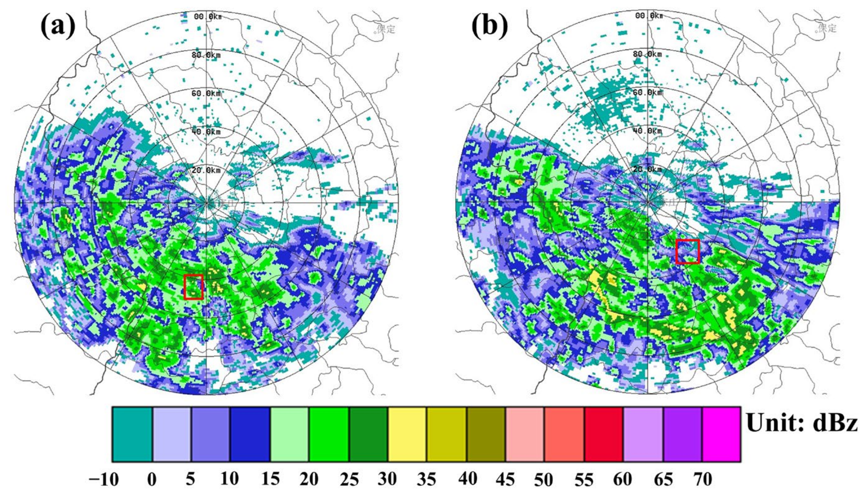
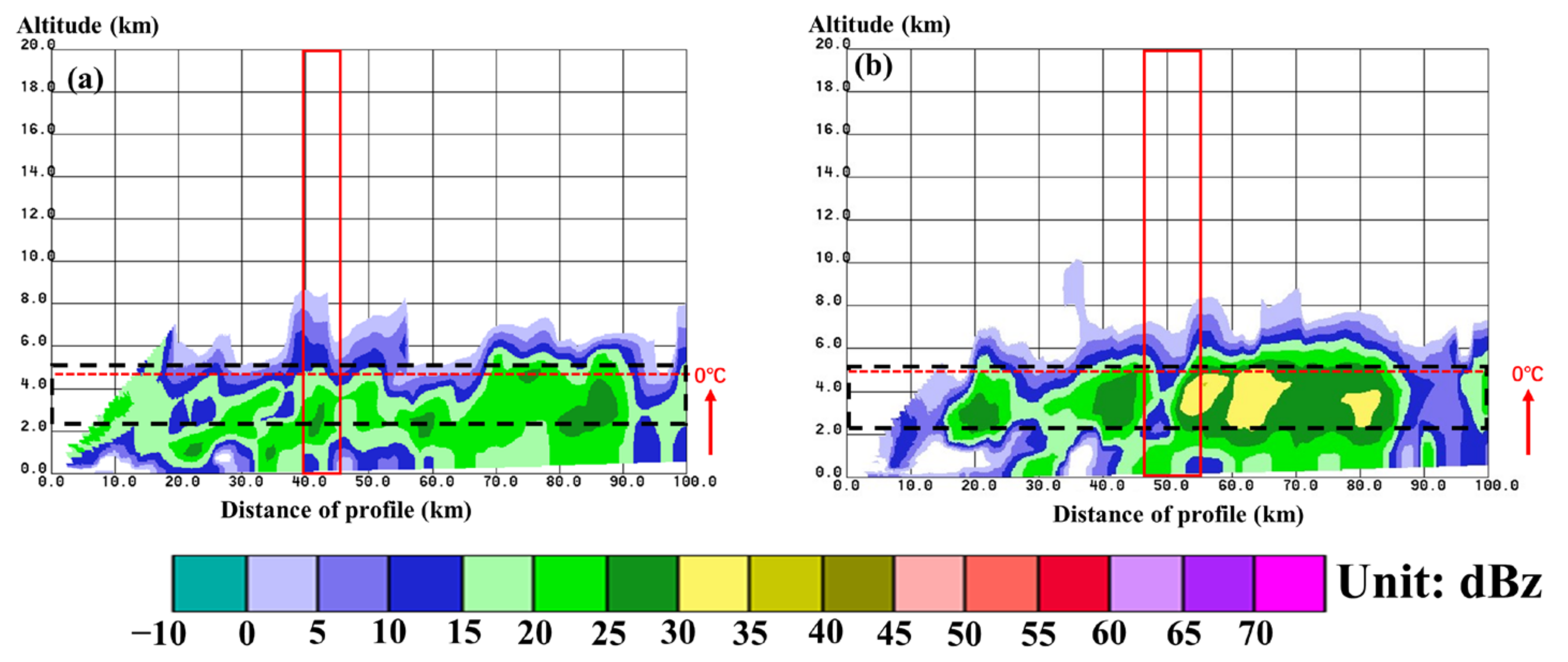
In this paper, SA-band Doppler weather radar (38°21′7″N, 114°42′43″E) in Shijiazhuang and SA-band Doppler weather radar (36°36′11″N, 114°28′59″E) in Handan were mainly used. The radar wavelength was 10 cm, and the volume scan was completed every 6 min. As could be seen from the radar reflectivity of the 2.4° and 3.4° elevation angles, there was melting bright band in each stage. The observations in 2017 were in the southern parts of the cloud system, and the observations in 2018 and 2019 were in the northern part of the cloud system (Figure 3, Figure 4 and Figure 5). From the vertical structure of radar echo, it could be observed that the V1, V2, and V3 detections on 22 May 2017 were in the strong echo region, while the rest were in the typical stratiform cloud region (Figure 6). From the radar echo image on 21 May 2018, it could be observed that there is a convective cell in the cloud in the vertical detection area of the V1 segment, and the other processes are layered echo area. The radar reflectivity of the V3 section weakens obviously at the height of 3 km (Figure 7). From the vertical radar reflectivity, it could be seen that on 24 August 2019, the detection in section V8 was located outside the convective cell. There were melting signatures based on the strengthening of the radar reflectivity below the 0 °C layer in both vertical detection areas, and the bottom of the melting layers were relatively low (Figure 8).
In the observation periods of 2017 and 2018, the cloud systems were in the stratocumulus development stage, there were strong convective echoes embedded in the stratiform cloud area at both of the two stages, and the precipitation in these two stages was strong. In 2019, the echo of the detected cloud system was weak and the precipitation was also weak, so the detected cloud system was stratocumulus in a mature stage.

3. Result

3.1. Vertical Distribution of Microphysical Characteristics in Clouds

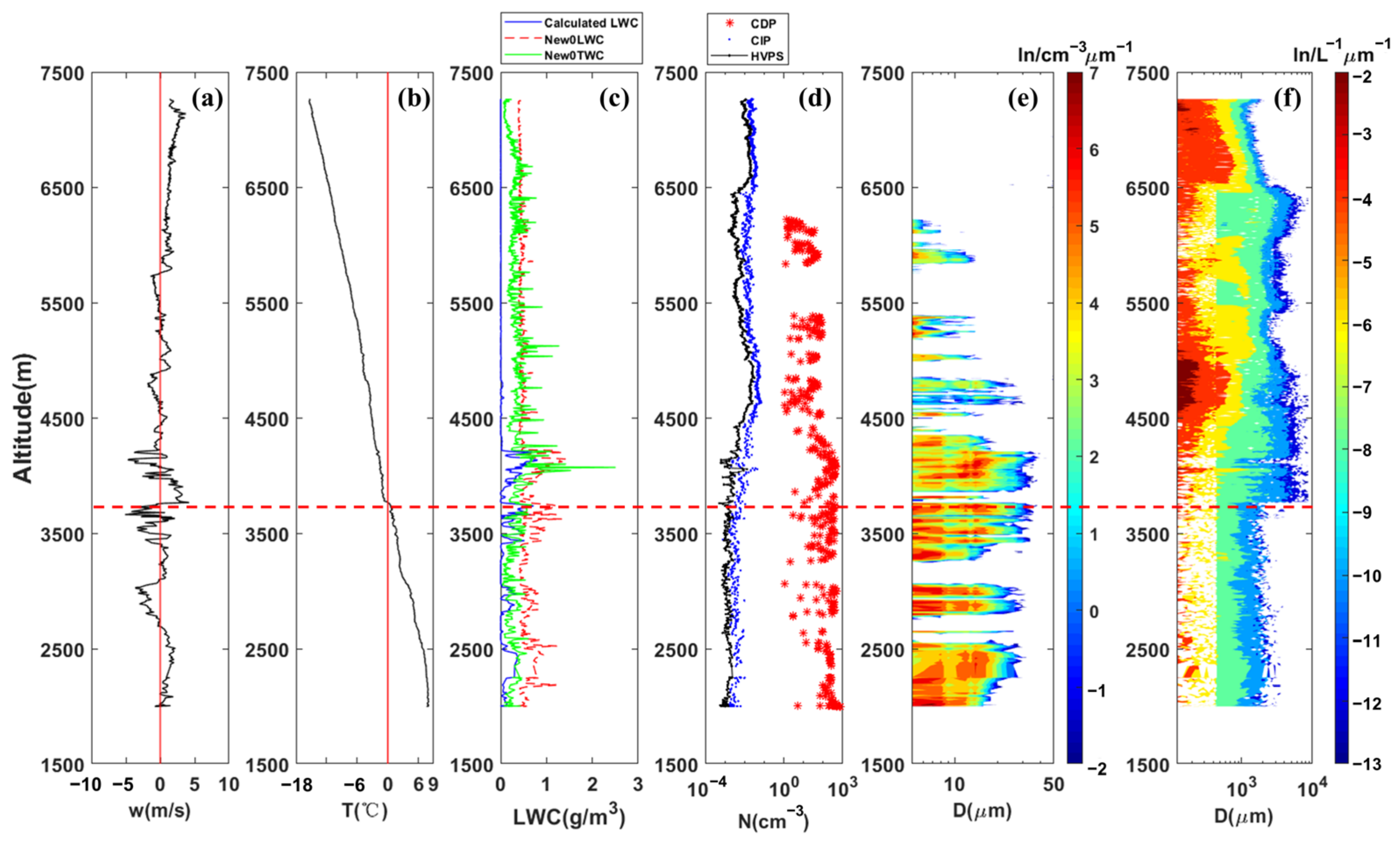
On 22 May 2017, the detection of the V1 (Figure 9) and V2 (Figure S1 in Supplementary Materials) segments were in the convective cell region embedded in the stratiform cloud, the detection of the V3 segment (Figure S2 in Supplementary Materials) was in the convective cell edge, and the detections of the V4 (Figure 10) and V5 (Figure S3 in Supplementary Materials) segments were in the stratiform cloud regions. It was shown in Figure 9 that the peak concentrations of the HVPS particles are concentrated in small to medium sized particles. In the stratiform cloud region, the number concentration of particles was low, but with the decrease of height, the peak number concentration gradually tended toward the particles with medium diameter. The CDP particles presented a dominantly multi-modal distribution, and the HVPS particles presented a bimodal distribution (6700 m) in the convective cell, which was higher than that in the stratiform cloud area (3800–4000 m). The convective cell has higher liquid water content, the ice particles have better riming growth conditions. In the convective cell, the particle number concentrations detected by the CDP, the CIP and the HVPS were higher than that in the stratiform cloud area, and the particle spectrum was also wider. There were more larger particles in the convective cell, and the strong gravity drag of large particles made the downdraft in the convective cell stronger than that in the stratiform cloud area. It was found that the 0 °C in the convective cell area was higher than that in the stratiform cloud area (Table 3), and at the end of the detection stage, the temperatures of the same altitude level of V1 and V2 were higher than other stages (Figure 9 and Figure 10).
On 21 May 2018, there existed some areas with high super-cooled liquid water content but low ice particle number concentration, which had strong precipitation enhancement potentiality. The CDP was generally unimodal, but bimodal at the height of 1750 m. The HVPS showed a bimodal distribution at the heights of 4800 m and 3300 m, and the peak particle diameter increases with the decrease of height. According to the vertical radar reflectivity, the convective cell embedded in stratiform clouds was detected in the V1 section, and the downdraft in the V1 section was stronger than that in other stages. In the precipitation particle spectrum of the V1 segment, it is observed that the peak particle diameter increases in the isothermal layer, and there is collision of unmelted particles at this time. The temperature of the V1 section was higher than those of the V2 and V3 sections, and the 0 °C layer of the V1 section was higher than those of the V2 and V3 sections (Table 3, Figures S4–S6 in Supplementary Materials).
Two vertical detections on 24 August 2019 also showed that the spectrum width of precipitation particles below the 0 °C layer was significantly smaller than that in the negative temperature layer. In the melting process of ice precipitation particles, the particle spectrum was mainly unimodal, with bimodal distribution in the V4 section (Figure S7 in Supplementary Materials) at 4300 m, 3400 m, and 2850 m, and in the V8 section (Figure S8 in Supplementary Materials) at 4300 m, 3900 m, and 3550 m. The region with larger peak diameter corresponded to wider particle spectrum. This indicated that the melting rates of ice particles with different particle sizes are different, and the melting rates of ice particles with larger particle sizes were relatively faster.

3.2. The Image of Ice Particles

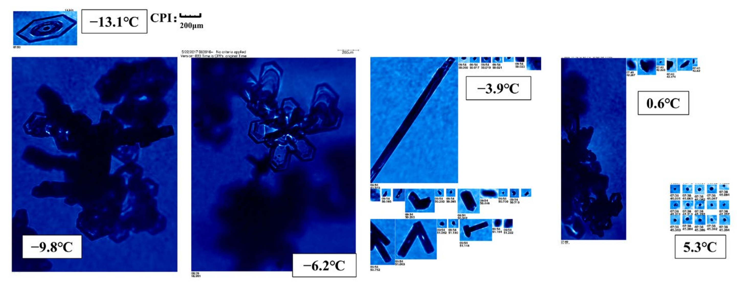
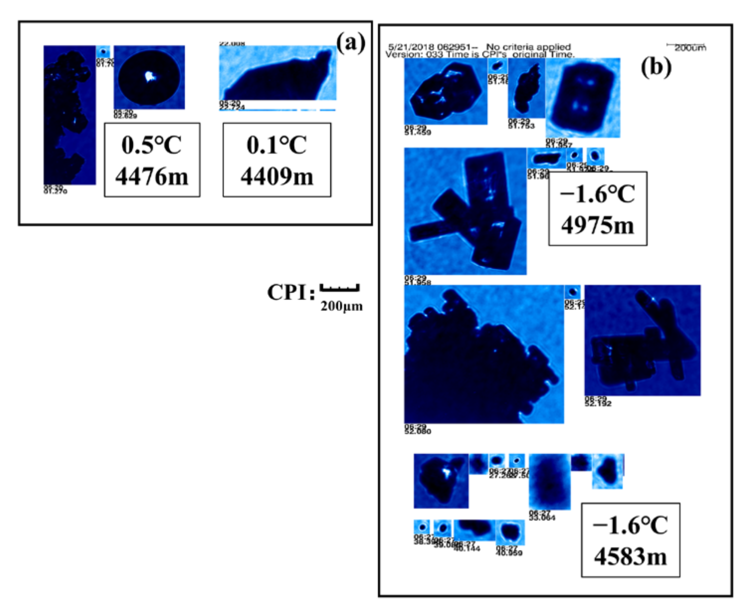
On 22 May 2017, the temperature of the detection process was low. It could be seen that plate crystals existed in the high negative temperature layer (−13 °C), column crystals existed in the negative temperature layer near zero (−3 °C), and rime-attached ice phase particles appeared in other areas (Figure 11). Close to the 0 °C layer, there still existed the riming growth of ice particles. Below the 0 °C layer, some large drops existed. At the temperature of −3.4 °C, it could be seen that the particles have smooth edges, which indicated that the ice particles have begun to melt in the negative temperature layer above the 0 °C layer.
On 21 May 2018, aggregates formed by collision and riming of ice particles were observed in the negative temperature layer close to the 0 °C layer. There were large drops below the 0 °C layer. At the V2 detection stage, it was found that the ice phase particles at the same temperature had different shapes, while at different heights. At the same temperature (−1.6 °C), the particles at the height of 4975 m were dominated with aggregates of columns, co-exited with riming process, while most of the particles at 4583 m were already melted based on their regular edge. In the negative temperature layer close to the 0 °C layer, as the particles began to melt, absorbing latent heat, so an isothermal layer was formed near the 0 °C layer (Figure 12).
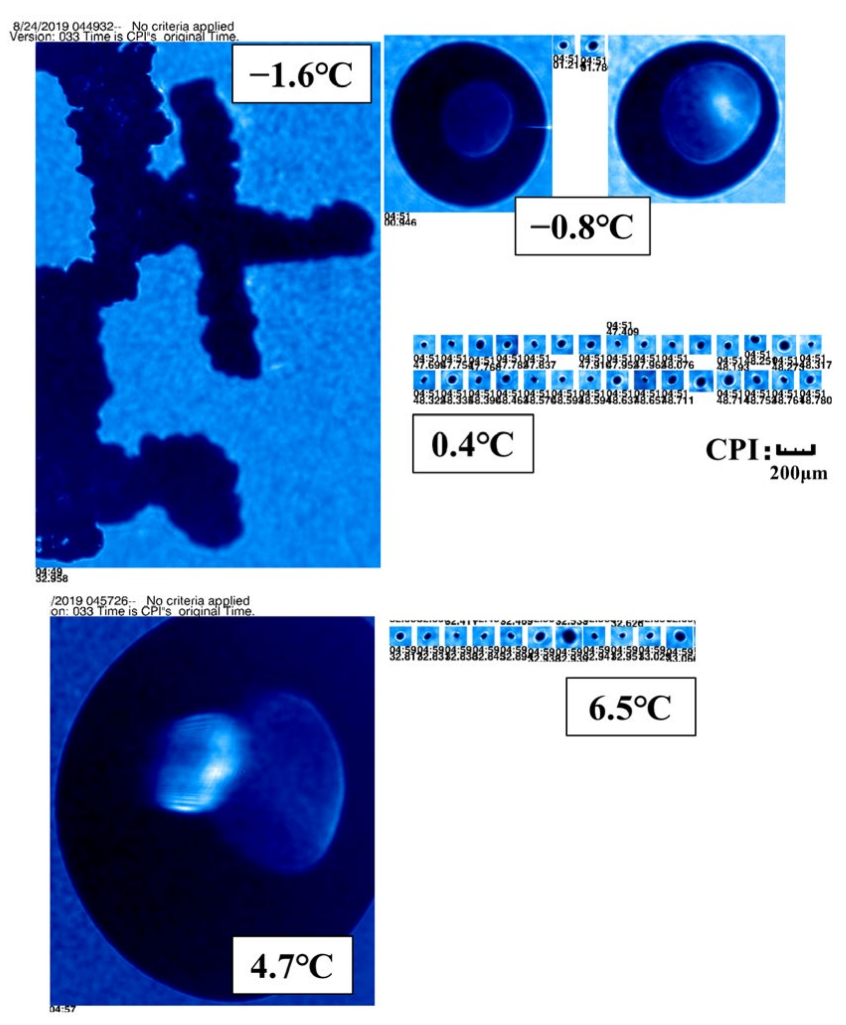
On 24 August 2019, the riming of particles in the negative temperature layer was strong. Large droplets were observed near the 0 °C layer. When the temperature reached 6.5 °C, particles with irregular edges were still observed (Figure 13).

3.3. Particle Size Distribution (PSD)

According to Gunn and Marshall (1958), based on ground observation, the size spectrum distribution of ice particles conformed to the form of negative exponential:
n D = N 0 · e λ D
In which D is the diameter of the ice phase particle; and N 0 and λ are the intercept and slope.
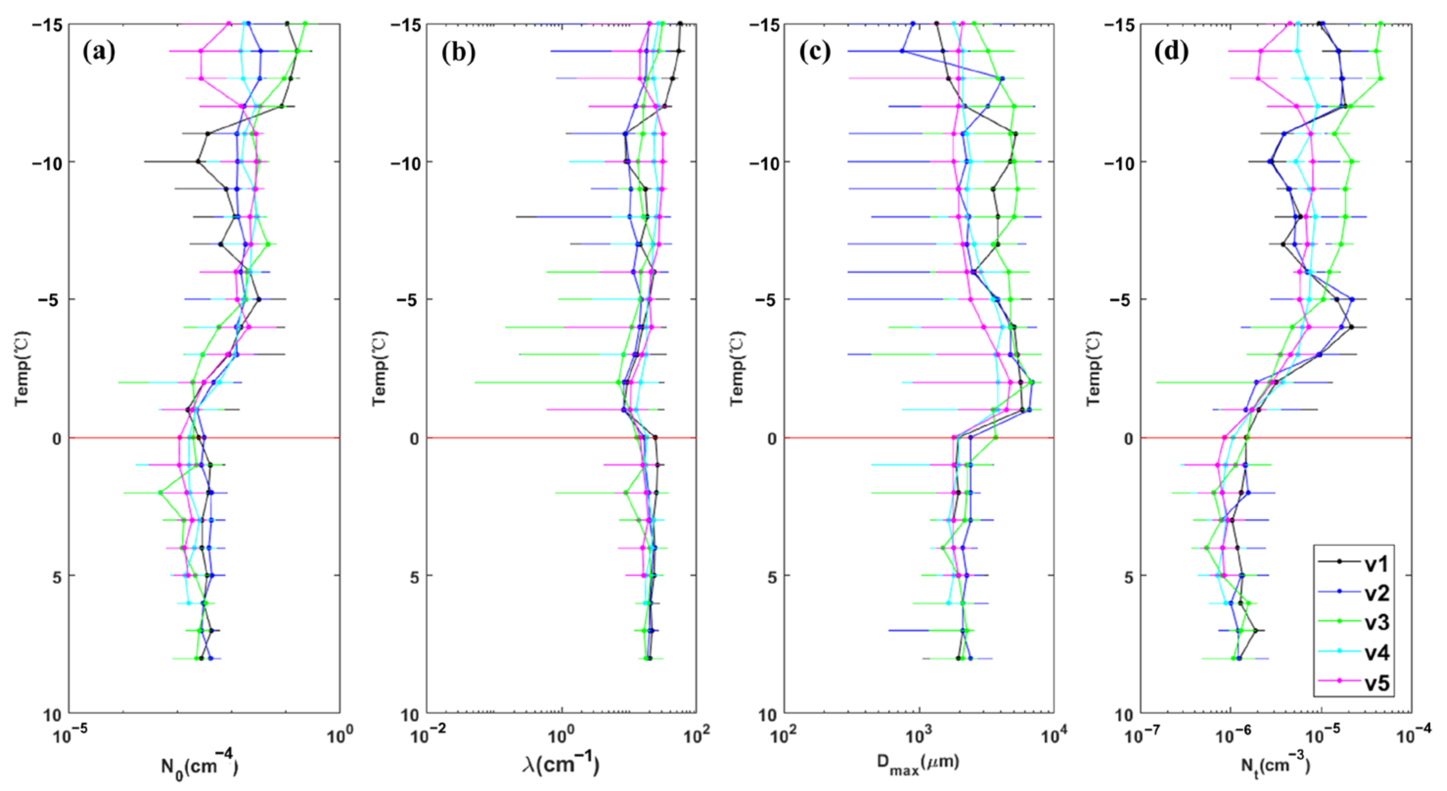
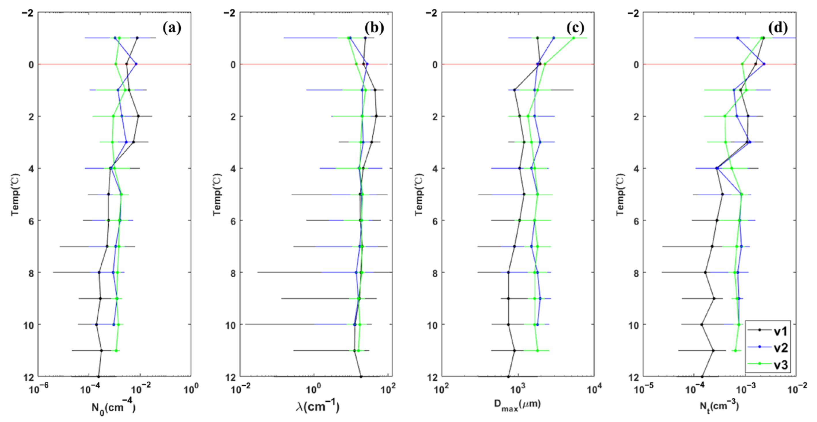
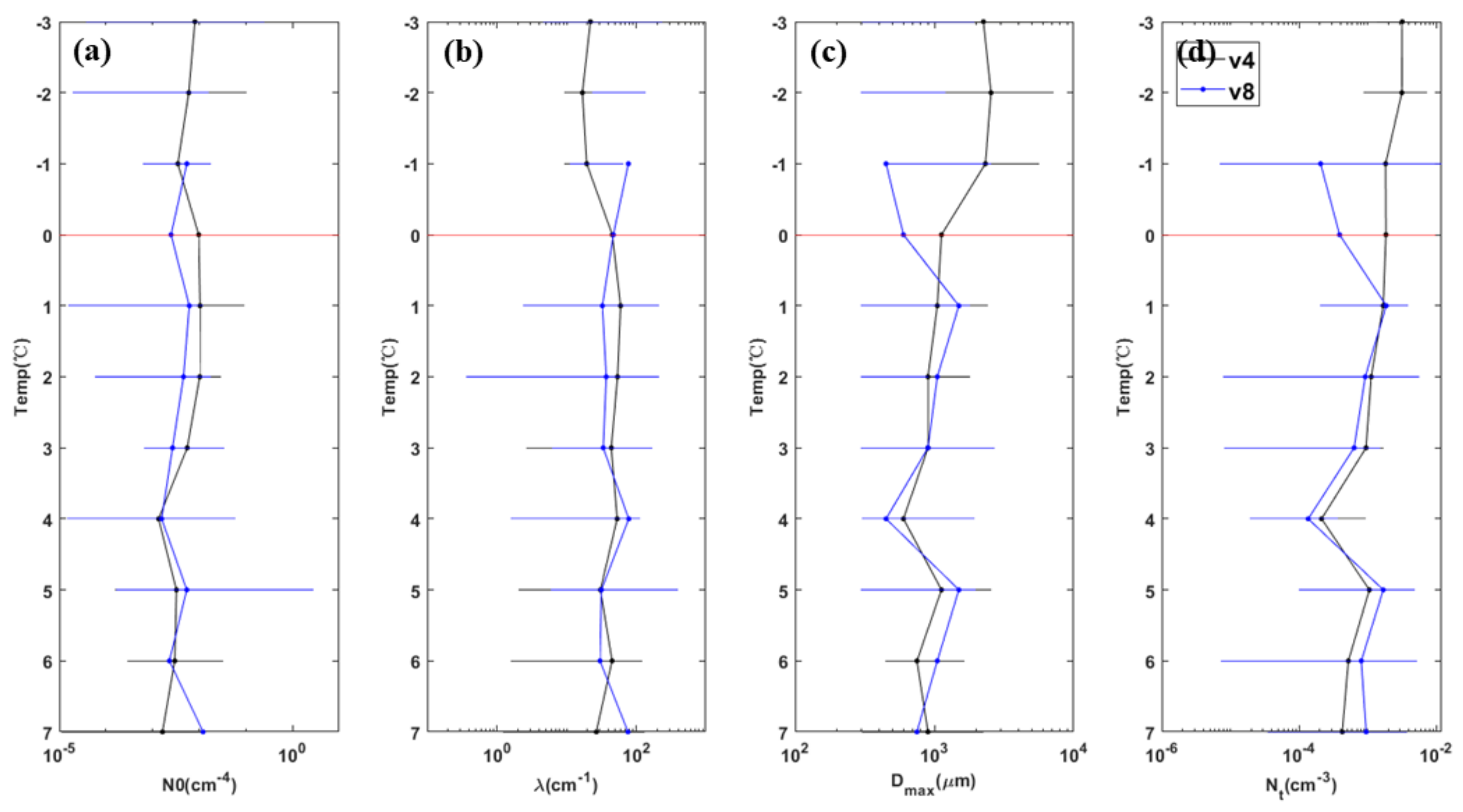
In terms of vertical distribution (Figure 14, Figure 15 and Figure 16), N 0 above the 0 °C layer was larger than that below the 0 °C layer in each stage, and N 0 above the 0 °C layer showed a decreasing trend with the increasing temperature. At each stage, λ above the 0 °C layer was less than that below the 0 °C layer. In the negative temperature layer close to the 0 °C layer, λ showed an increasing trend with increasing temperature. The maximum particle size ( D m a x ) observed by the HVPS was greater above the 0 °C layer than that below the 0 °C layer. In general, N t above the 0 °C layer was greater than that below the 0 °C layer. In the negative temperature layer close to the 0 °C layer, N t decreased with increasing temperature.
On 22 May 2017, the N 0 , λ, and N t of the V1 and V2 sections in the convective cell, were larger than other areas. In the convective cell between −13.5 °C and −11 °C, N t , N 0 , and λ decreased with the increase of temperature, and D m a x increased with the increase of temperature or had no obvious change, which was caused by aggregation. In the negative temperature layer from −10 °C to −5 °C, N t , N 0 , and λ in the convective cell are smaller than those in the stratiform cloud region, and D m a x are larger than those in the stratiform cloud region. The observed data indicate that there are more small-sized particles in the upper stratiform cloud region at this height. In the cloud, N t reaches its maximum value in the range of −5 °C to −4 °C, and the Hallett-Mossop ice crystal multiplication mechanism exists in this stage, which further proves that the riming process in the convective cell is more active. From −3.5 °C to the 0 °C layer, N t and N 0 decreased with temperature increasing, and D m a x decreased and λ increased with increasing temperature starting from −1 °C, so it could be judged that ice phase particles have started to melt above the 0 °C layer (Figure 14).
In the three detection processes on 21 May 2018, from the negative temperature layer near the 0 °C layer to the 0 °C layer of the V1 and V2 sections, N t increased and D m a x decreased with the increase of temperature. From the negative temperature layer near the 0 °C layer to the 0 °C layer, the N t of V1 section decreased with the increase of temperature, and D m a x increased, which was caused by aggregation. In the two processes, there may be ice phase particle sublimation in the negative temperature layer near the zero layer. The large particles were broken into small particles, resulting in the increase of the total particle concentration and decrease of the maximum particle size. The V1 segment experienced the convection cell during the measurement, and its N 0 , λ, and N t were larger than other detection areas in the negative temperature layer. From 1 °C to 4 °C, N 0   a n d   λ of the V1 segment was larger than other detections, and D m a x was less than other detections above and below the 0 °C layer. Below the 4 °C level, N t was less than other detections (Figure 15).
On 24 August 2019, in V4 section from −2 °C to 0 °C, N 0 , λ, and D m a x decreased, and N t did not change significantly. In this phase, particles melted and sublimated at the same time. In V8 section, N t increased from 0.5 °C to 0 °C layer, D m a x increases, w i t h   N 0 and λ decreased, sublimation and aggregation appeared at the same time in this stage. The relative humidity of V8 segment is smaller than that of V4 section. In V4 section, the particles melted in the negative temperature layer close to 0 °C layer, and the total particle concentration and maximum particle diameter decreased accordingly. In V8 section, the sublimation process led to the increase of the total particle concentration, and the decrease of the maximum particle diameter. (Figure 16).
It was found that the particle spectrum parameters were significantly related to temperature and maximum particle size. On the whole, the intercept ( N 0 ) was positively correlated with temperature (T), except that the relationship of the V3 section in 2018 is not obvious. The exponential function based on e could better fit the relationship between the two (Table 4, Figure 17). Data from each detection have shown that the slope (λ) and intercept ( N 0 ) are positively correlated, and the overall fitting found that logarithmic function could well fit the relationship between them. The variation rules of data above and below the 0 °C layer were different. The particles below the 0 °C layer changed faster than those above the 0 °C layer. The fitting coefficients of the two were different, and the coefficient above the 0 °C layer was lower than that below the 0 °C layer (Table 4, Figure 18). It could be found that the slope (λ) was positively correlated with the largest diameter ( D m a x ). The power function could well fit the relationship between them (Table 4, Figure 19).

4. Discussion

Generally, there are differences in cloud macro, micro, and precipitation characteristics in different parts of stratocumulus clouds. In this paper, based on the analysis of ten flights’ cloud physical observation data, it was also found that the temperature of the cumulus cloud area at the same height was higher than that of the stratus cloud area, and the height of the 0 °C layer was also higher than that of the stratus cloud area. This was supposed to be due to stronger updrafts in the embedded cumulus leading to more condensation, releasing more latent heat. Along with stronger updrafts, ice particles grew to larger particle sizes and fell to form precipitation, which made the spectrum intercept and slope parameters in the melting level of the cumulus area higher than those of the same stratiform cloud area. At the same time, the stronger gravitational dragging at the cumulus cloud, induced stronger downdrafts.
The analysis of the detection data of different flights showed that the particle spectrum parameters and their evolution in the melting layer may be different from those in the negative temperature layer. With the beginning of melting, the spectral width and number concentration of particles decreased. However, the melting process of ice particles might be accompanied by a variety of physical processes, including sublimation, fragment, and aggregation, resulting in inconsistent evolution of particle spectrum parameters in different flights. The latent heat absorption in the melting process might lead to a decrease in the rate of temperature change with height, and an approximate isothermal layer appears around the 0 °C layer.
With the melting of ice particles, the intercept and slope of the particle spectrum below the 0 °C layers and the correlation between them have changed significantly compared with the negative temperature layer, which means that in conducting cloud microphysical parameterization and inversion research of cloud microstructure through radar and satellite observation data, it is better to adopt a parameter relationship and parameters different from the negative temperature layer below the 0 °C layers or the melting layer.
The differences in cloud microphysical characteristics in different regions require us to carry out cloud characteristics research in regions with different climatic backgrounds and underlying surface characteristics, which is very important for weather and climate prediction. The parameters and their relationships obtained in this paper have certain reference significance for North China and similar climate regions.
At present, most studies focus on the differences in precipitation mechanisms in different parts of stratocumulus clouds [24], but little attention is paid to the differences in updraft and temperature in different parts of the clouds. Compared with the studies in China, the studies on the North China stratocumulus clouds are mostly concentrated in the negative temperature layer [1], while the particle spectrum distribution under the 0 °C layer is lacking study. As shown in Table 5, the spectrum parameters of particles in different temperature ranges in stratocumulus clouds are different. The analysis of a particle spectrum parameters relationship usually focuses on temperature (T)-intercept ( N 0 ) and intercept ( N 0 )-slope (λ) [22], but in China the research mostly focuses on the relationship between N 0 and λ [11]. In this paper, there is a new study on the relationships between T- N 0 , N 0 -λ, and λ- D m a x , which can provide a reference for using temperature prediction particle spectrum distribution for China. The particle spectrum parameters of stratocumulus clouds found in this paper are different from other studies abroad and in China, which proves that the study of stratocumulus cloud observation in different regions is very necessary.

5. Conclusions

From the observation data of ten flights of three precipitation processes, there were differences in the macro- and micro-characteristics of cumulus and stratiform areas of stratocumulus clouds. The particle spectrum parameters and their evolutions below the melting level were also different from those in the negative temperature layer. Based on the analysis, it can be found that study on the distribution and evolution of cloud vertical structure and particle spectrum parameters in different parts of the stratocumulus cloud, especially the evolution of the particle spectrum in the ice particle melting layer and below, may have great significance for the prediction of precipitation intensity. The specific conclusions of this paper are as follows:
(1) The downdraft in the cumulus cloud area was stronger, and the temperature at the same height was higher than that in the stratus cloud area, and the 0 °C layer height was correspondingly higher. In terms of particle spectrum parameters, the intercept and slope parameters of the particle spectrum of the cumulus area below the melting layer were higher than those of the stratus cloud area, for the same weather process. There were significant differences in the characteristics of vertical evolution and parameter evolution of the particle spectra in different parts of stratocumulus clouds, which showed that the microphysical characteristics of stratus clouds and cumulus clouds area were different.
(2) In different vertical detections, it was found that the ice phase particles have narrowed the particle spectrum, decreased the total concentration, and smoothed the edges of the ice particle images in the negative temperature layer near the 0 °C level, indicating that the ice particles have begun to melt in the negative temperature layer near the 0 °C level. As the ice particles began to melt, the D m a x of the particle spectrum decreased rapidly, indicating that the larger particles might melt earlier than the middle-sized ones. In different flights, the variation trends of intercept, slope, maximum particle size, and total concentration of particle spectrum with the increase of temperature, were not consistent. The analysis of the evolution of the spectrum parameters showed that there might be sublimation, fragmentation, and aggregation in the melting process of ice phase particles. In addition, with the latent heat released by the melting process of ice particles, it was possible to have an approximate isothermal layer with a small temperature change rate around the 0 °C level.
(3) The melting process changed the spectral parameters greatly and also changed the correlation between the intercept and slope of the particle spectrum. The slope below the 0 °C level increased with the increase of intercept, which was greater than that above the 0 °C level. Through the fitting calculation of the data of ten flights, the expression relation of N 0 increasing with temperature for North China was obtained. It was also found that, with the increase of the slope parameter of the precipitation particle spectrum, the maximum particle size of the particle spectrum shows an exponential decrease trend.

Supplementary Materials

The following supporting information can be downloaded at: https://www.mdpi.com/article/10.3390/rs15082168/s1.

Author Contributions

X.L. conceived the study; J.W. contributed to the investigation; J.X. analyzed the results and contributed to the original draft preparation; X.L. contributed to the reviewing and editing. All authors have read and agreed to the published version of the manuscript.

Funding

National Natural Science Foundation of China (Grant Nos. 41975176 and 42061134009).

Data Availability Statement

Data available upon request from all the authors.

Acknowledgments

The authors are grateful to three anonymous reviewers and associate editors for providing valuable comments and feedbacks on this work. We acknowledge the High Performance Computing Center of Nanjing University of Information Science and Technology for their support of this work.

Conflicts of Interest

The authors declare no conflict of interest.

References

  1. Hou, T.J.; Lei, H.C.; He, Y.J.; Zhao, Z.; Hu, Z.X. Aircraft Measurements of the Microphysical Properties of Stratiform Clouds with Embedded Convection. Adv. Atmos. Sci. 2021, 38, 966–982. [Google Scholar] [CrossRef]
  2. Zhu, S.C.; Guo, X.L. Ice crystal habits, distribution and growth process in stratiform clouds with embedded convection in North China: Aircraft measurement. Acta Meteor. Sinica. 2014, 72, 366–389. [Google Scholar]
  3. Qi, P.; Guo, X.L.; Lu, G.X.; Duan, Y.; Li, B.D.; Wu, Z.H.; Dong, X.B.; Hu, X.F.; Yang, Y.S.; Fan, H.; et al. Aircraft Measurements of a Stable Stratiform Cloud with Embedded Convection in Eastern Taihang Mountain of North China: Characteristics of Embedded Convection and Melting Layer Structure. Chin. J. Atmos. Sci. 2019, 43, 1365–1384. [Google Scholar]
  4. Kang, Z.M.; Li, Z.L.; Liu, W.; Dong, X.B.; Mai, R.; Sun, Y.W. Aircraft observations on physical properties of precipitation clouds in Hebei province. J. Meteor. Environ. 2019, 35, 1–7. [Google Scholar]
  5. Yang, J.F.; Hu, X.F.; Lei, H.C.; Duan, Y.; Lv, F.; Zhao, L.W. Airborne Observations of Microphysical Characteristics of Stratiform Cloud Over Eastern Side of Taihang Mountains. Chin. J. Atmos. Sci. 2021, 45, 88–106. [Google Scholar]
  6. Gao, Q.; Guo, X.L.; He, H.; Liu, X.E.; Huang, M.Y.; Ma, X.C. Numerical Simulation Study on the Microphysical Characteristics of Stratiform Clouds with Embedded Convections in Northern China based on Aircraft Measurements. Chin. J. Atmos. Sci. 2020, 44, 899–912. [Google Scholar]
  7. Hu, X.F.; Xiao, H.X.; Cui, Y.; Lv, F.; Zhao, L.W.; Ji, X.S. Microphysical characteristics of precipitating stratiform clouds in north China revealed by joint observations of an aircraft and a polarimetric radar. J. Atmos. Sci. 2022, 79, 2799–2811. [Google Scholar] [CrossRef]
  8. Wei, L.; Lei, H.; Hu, W.; Huang, M.; Zhang, R.; Zhang, X.; Hou, T.; Lv, Y. An Analysis of the Microstructure of the Melting Layer of a Precipitating Stratiform Cloud at the Dissipation Stage. Atmosphere 2022, 13, 284. [Google Scholar] [CrossRef]
  9. Huang, M.S.; Lei, H.C. Ice particle habit distribution in stratiform clouds at different precioitation stages. Trans. Amos. Sci. 2022, 45, 247–256. [Google Scholar]
  10. Zhao, Z.; Lei, H. Observed microphysical structure of nimbostratus in northeast cold vortex over China. Atmos. Res. 2014, 142, 91–99. [Google Scholar] [CrossRef]
  11. Feng, Q.J.; Niu, S.J.; Hou, T.J.; Fan, X.P.; Shen, D.D.; Yang, J.M. Aircraft-Based Observation of the Physical Characteristics of Snowfall Cloud in Shanxi Province. Chin. J. Atmos. Sci. 2021, 45, 1146–1160. [Google Scholar]
  12. Rauscher, S.A.; Pal, J.S.; Diffenbaugh, N.S.; Benedetti, M.M. Future changes in snowmelt-driven runoff timing over the western US. Geophys. Res. Lett. 2008, 35, L16703. [Google Scholar] [CrossRef]
  13. Ashfaq, M.S.; Ghosh, S.C.; Kao, S.C.; Bowling, L.C.; Mote, P.; Touma, D.; Rauscher, S.A.; Diffenbaugh, N.S. Nearterm acceleration of hydroclimatic change in the western U.S. J. Geophys. Res. Atmos. 2013, 118, 10676–10693. [Google Scholar] [CrossRef]
  14. Marty, C.; Tilg, A.M.; Jonas, T. Recent evidence of largescale receding snow water equivalents in the European Alps. J. Hydrometeorol. 2017, 18, 1021–1031. [Google Scholar] [CrossRef]
  15. Mote, P.W.; Li, S.H.; Lettenmaier, D.P.; Xiao, M.; Engel, R. Dramatic declines in snowpack in the western US. Npj. Clim. Atmos. Sci. 2018, 1, 1–6. [Google Scholar] [CrossRef]
  16. Tamang, S.K.; Ebtehaj, A.M.; Prein, A.F.; Heymsfield, A.J. Linking global changes of snowfall and wet-bulb temperature. J. Clim. 2020, 33, 39–59. [Google Scholar] [CrossRef]
  17. Kain, J.S.; Goss, S.M.; Baldwin, M.E. The melting effect as a factor in precipitation-type forecasting. Weather. Forecast. 2000, 15, 700–714. [Google Scholar] [CrossRef]
  18. Oraltay, R.G.; Hallett, J. Evaporation and melting of ice crystals: A laboratory study. Atmos. Res. 1989, 24, 169–189. [Google Scholar] [CrossRef]
  19. Matsuo, T.; Sasyo, Y. Empirical formula for the melting rate of snowflakes. J. Meteorol. Soc. JPN. Ser. II 1981, 59, 1–9. [Google Scholar] [CrossRef]
  20. Mitra, S.K.; Vohl, O.; Ahr, M.; Pruppacher, H.R. A wind tunnel and theoretical study of the melting behavior of atmospheric ice particles. IV: Experiment and theory for snow flakes. J. Atmos. Sci. 1990, 47, 584–591. [Google Scholar] [CrossRef]
  21. Heymsfield, A.J.; Bansemer, A.; Field, P.R.; Durden, S.L.; Stith, J.; Dye, J.E.; Hall, W.; Grainger, T. Observations and parameterizations of particle size distributions in deep tropical cirrus and stratiform precipitating clouds: Results from in situ observations in TRMM field campaigns. J. Atmos. Sci. 2002, 72, 2902–2928. [Google Scholar] [CrossRef]
  22. Heymsfield, A.J.; Bansemer, A.; Poellot, M.R.; Wood, N. Observations of ice microphysics through the melting layer. J. Atmos. Sci. 2015, 72, 2902–2928. [Google Scholar] [CrossRef]
  23. Liu, S.Y.; Zhao, C.F.; Zhou, Y.Q. SPEC airborne cloud detection system and its cloud physics research progress. Torrential Rain Disaster 2021, 40, 280–286. [Google Scholar]
  24. Guo, X.L.; Fu, D.H.; Guo, X.; Fang, C.G. Study on physical plane observation of cloud precipitation in China. JAM 2021, 32, 641–645. [Google Scholar]
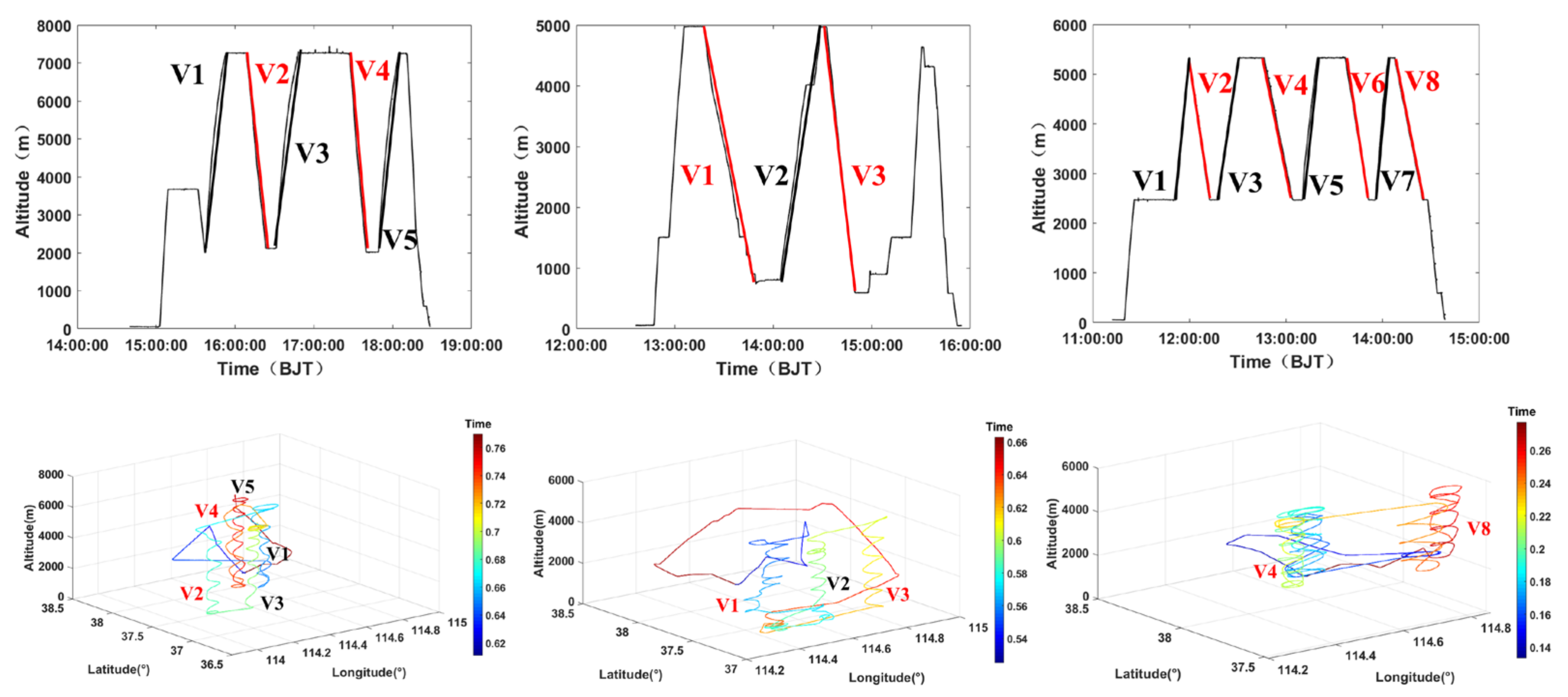
Figure 1. Flight track of the 3 aircraft (from left to right is 22 May 2017, 21 May 2018, and 24 August 2019).
Remotesensing 15 02168 g001
Figure 2. Cumulative precipitation: (a) is for 22 May 2017, (b) is for 21 May 2018, and (c) is for 24 August 2019.
Remotesensing 15 02168 g002
Figure 3. 22 May 2017 (a) 17:30, 2.4° elevation angle PPI, (b) 17:54, 3.4° elevation angle PPI. The red rectangle box is the aircraft detection area.
Remotesensing 15 02168 g003
Figure 4. 21 May 2018 (a) 13:18, 2.4° elevation angle PPI, (b) 14:18, 2.4° elevation angle PPI, (c) 14:36, 3.4° elevation angle PPI. The red rectangle box is the aircraft detection area.
Remotesensing 15 02168 g004
Figure 5. 24 August 2019, (a) 12:48, 3.4° elevation angle PPI, (b) 14:18, 2.4° elevation angle PPI. The red rectangle box is the aircraft detection area.
Remotesensing 15 02168 g005
Figure 6. 22 May 2017, (a) 15:42 of V1, (b) 16:12 of V2, (c) 16:36 of V3, (d) 17:30 of V4, (e) 17:54 of V5. The red rectangle box is the aircraft detection area.
Remotesensing 15 02168 g006
Figure 7. 21 May 2018, (a) 13:18 of V1, (b) 14:18 of V2, (c) 14:42 of V3. The red rectangle box is the aircraft detection area.
Remotesensing 15 02168 g007
Figure 8. 24 August 2019, (a) 12:48 of V4, (b) 14:18 of V8. The red rectangle box is the aircraft detection area.
Remotesensing 15 02168 g008
Figure 9. The aircraft observation data set of V1 on 22 May 2017 in the convective cell, (a) vertical velocity (the red line is 0, units: m s−1, °C); (b) temperature (units: °C, the red line is 0); (c) calculated liquid water content (calculated LWC), probe detected liquid water content (New0LWC), probe detected total water content (New0TWC) (units: g m−3); (d) particle number concentration of the CDP, the CIP, and the HVPS (units: cm−3); (e) particle spectrum of CDP (units: cm−3μm−1); (f) particle spectrum of the CIP (100–400 μm) and the HVPS (400–8700 μm) (units: L−1μm−1). The red dotted line is the 0 °C layer.
Remotesensing 15 02168 g009
Figure 10. The aircraft observation data set of V4 on 22 May 2017 in the stratiform cloud area, (a) vertical velocity (the red line is 0, units: m s−1, °C); (b) temperature (units: °C, the red line is 0); (c) calculated liquid water content (calculated LWC), probe detected liquid water content (New0LWC), probe detected total water content (New0TWC) (units: g m−3); (d) particle number concentration of the CDP, the CIP, and the HVPS (units: cm−3); (e) particle spectrum of CDP (units: cm−3μm−1); (f) particle spectrum of the CIP (100–400 μm) and the HVPS (400–8700 μm) (units: L−1μm−1). The red dotted line is the 0 °C layer.
Remotesensing 15 02168 g010
Figure 11. Particles image of the flight on 22 May 2017.
Remotesensing 15 02168 g011
Figure 12. Particles image of the flight on 21 May 2018, (a) V1 stage, (b) V2 stage.
Remotesensing 15 02168 g012
Figure 13. Particles image of the flight V4 on 24 August 2019.
Remotesensing 15 02168 g013
Figure 14. The parameters of 22 May 2017, (a) intercept ( N 0 ), (b) slope (λ), (c) the maximum particle size ( D m a x ), (d) the total particle concentration ( N t ). The red line is the 0 °C layer.
Remotesensing 15 02168 g014
Figure 15. The parameters of 21 May 2018, (a) intercept ( N 0 ), (b) slope (λ), (c) the maximum particle size ( D m a x ), (d) the total particle concentration ( N t ) The red line is the 0 °C layer.
Remotesensing 15 02168 g015
Figure 16. The parameters of 24 August 2019, (a) intercept ( N 0 ), (b) slope (λ), (c) the maximum particle size ( D m a x ), (d) the total particle concentration ( N t ) The red line is the 0 °C layer.
Remotesensing 15 02168 g016
Figure 17. The relationship of N 0 and T.
Remotesensing 15 02168 g017
Figure 18. The relationship of N 0 and λ.
Remotesensing 15 02168 g018
Figure 19. The relationship of λ and D m a x .
Remotesensing 15 02168 g019
Table 1. Details of the observation flights.
Flight Detection Time (Beijing Time)Range of Height (m)Range of Temperature (°C)Rate of Descent (m/s)Width of Detection (km)
22 May 2017V115:37:11–15:53:067263–1998−15.4–8.15.5110.72
V216:08:32–16:23:387263–2121−15.7–8.25.689.99
V316:31:10–16:48:597267–2107−15.6–8.64.839.40
V417:27:07–17:39:547247–2009−16.1–5.56.8311.51
V517:48:59–18:04:277256–2011−15.9–4.95.657.90
21 May 2018V113:17:43–13:54:074971–784−1.2–12.41.9216.18
V214:04:17–14:30:004975–810−1.8–10.32.7013.39
V314:32:32–14:49:504958–590−1.6–11.34.217.35
24 August 2019V412:46:39–13:04:595297–2463−3–7.32.5811.10
V814:07:30–14:24:385328–2502−2.3–7.32.7510.47
Table 2. Particle probe and its parameters. (Reprinted/adapted with permission from Ref. [5]. 2023, Jiefan Yang).
Instrument NameEquipment ManufacturerMeasuring RangeResolutionUse
Passive Cavity Aerosol Spectrometer ProbeDMT30 channels, 0.1~3 μm0.1 μmUsed for the detection of an aerosol particle spectrum
Fast Cloud Droplet ProbeSPEC21 channels, 2~50 μm3 μmCloud particle spectrum
Cloud Droplet Probe (CDP)DMT30 channels, 2~50 μm Cloud particle spectrum
Cloud Imaging Probe (CIP)DMT62 channels, 25~1500 μm25 μmUsed to obtain a high-definition crystal grain spectrum and 2-dimensional particle image of ice, snow, cloud
Precipitation Imaging Probe (PIP)DMT62 channels, 100~6200 μm100 μmUsed to obtain precipitation particle spectrum and image
Cloud Imaging ProbeSPEC10~2000 μm2.3 μmUsed for cloud droplets, snow and ice crystals, raindrop images
2D-S OpticalSPEC10~1280 μm100 μmUsed for cloud droplets, snow and ice crystals, raindrop images
High Volume Precipitation Spectrometer (HVPS)SPEC150~19,200 μm150 μmUsed to obtain a clear precipitation particle spectrum and particle 2-dimensional image
LWCDMT0~3 g m−3 Liquid water content
TWCNevzorov0.005~3 g m−3 Liquid water content, ice, and snow crystal water content
AIMMS-20AventechTemperature: −50~50 °C
Vertical velocity: 0~50 m s−1
Altitude: 0~13.7 km
Temperature: 0.3 °C
Velocity: 0.75 m s−1
Altitude: 18.3 m
Used for measuring high temperature, pressure, humidity, wind, and aircraft motion parameters
Table 3. Comparison of microphysical quantities at different stages.
DetectionHeight of 0 °C Layer (m)CDP (cm−3)
(Max/Average)
CIP (cm−3)
(Max/Average)
HVPS (cm−3)
(Max/Average)
w (m/s)
Updraft
(Max/Average)
Downdraft
(Max/Average)
2017V13764725/5519.17/0.54 3.12   ×   10 2 / 7.87   ×   10 3 4.2/1.3−5.1/−1.0
V23612980/10626.7/0.87 4.44   ×   10 2 / 9.79 ×   10 3 7/2.3−4.2/−0.6
V33706948/492.67/0.66 6.01   ×   10 2 / 1.17 ×   10 2 6.2/2.3−2.2/−0.4
V43346261/190.39/0.09 1.06   ×   10 2 / 4.10 ×   10 3 10/2.7−1.9/−0.4
V53451360/170.79/0.14 1.68   ×   10 2 / 4.61 ×   10 3 4.3/0.9−8.4/−1.1
2018V147371419/1417/0.56 7.63   ×   10 3 / 4.84 ×   10 4 14.4/2.9−4.6/−1.5
V24201299/8.995.92/0.23 1.27   ×   10 2 / 1.28 ×   10 3 9.6/2.4−2.1/−0.4
V34265114/5.763.43/0.28 3.36   ×   10 3 / 8.58 ×   10 4 9.1/3.1−0.6/−0.2
2019V444961190/2173.44/0.17 7.3 ×   10 3 / 1.4 ×   10 3 3.7/1.4−3.9/−0.9
V84708693/1390.08/9.2 0.01 / 1.2 × 10 3 3.3/1.4−5.7/−1.1
Table 4. The fitting of relationships between spectral parameters.
Relation abc R 2
N 0 = e a · T 2 + b · T + c 8.6 × 10 4 −0.16129−5.500.60
λ = a · l n N 0 + b Above the 0 °C Layer5.6144.59 0.47
Below the 0 °C Layer12.11107.82 0.32
D m a x = a · λ b 5.02 × 10 4 −0.80 0.77
Table 5. Comparison of spectral parameters of different detection processes.
Detection Temperature (°C) The Maximum Particle Number Concentration ( c m 3 ) N 0 ( c m 4 ) λ   ( c m 1 )
Hou et al. (2021) [1]−12~010−110−6~10−210−1~101
Heymsfiled et al. (2015) [22]−4~410−10.01~10010~25
Feng et al. (2021) [11]−20~01020~10410~104
Xiong et al. (2023)−15.9~8.610−210−5~10010−2~102
Xiong et al. (2023)−1.8~12.410−210−6~10010−2~102
Xiong et al. (2023)−2.3~7.310−210−5~10010−1~102
Disclaimer/Publisher’s Note: The statements, opinions and data contained in all publications are solely those of the individual author(s) and contributor(s) and not of MDPI and/or the editor(s). MDPI and/or the editor(s) disclaim responsibility for any injury to people or property resulting from any ideas, methods, instructions or products referred to in the content.