Article

Optimizing Ecological Spatial Network Topology for Enhanced Carbon Sequestration in the Ecologically Sensitive Middle Reaches of the Yellow River, China

1
Beijing Key Laboratory of Precision Forestry, Beijing Forestry University, Beijing 100083, China
2
Department of Geographic Information Science, Hebei University of Engineering, Handan 056038, China
*
Author to whom correspondence should be addressed.
Remote Sens. 2023, 15(9), 2308; https://doi.org/10.3390/rs15092308
Submission received: 18 March 2023 / Revised: 15 April 2023 / Accepted: 24 April 2023 / Published: 27 April 2023

Abstract

:
The destruction of vegetation structure and quantity leads to the weakening of the carbon sequestration capacity of the ecosystem. Building an ecological spatial network is a potent method for studying vegetation spatial distribution structures. The relationship between the spatial distribution structure of vegetation networks and carbon sequestration, as approached from the perspective of complex network theory, is understudied. This study uses the minimum resistance model (MCR) and morphological spatial pattern analysis (MSPA) to study the eco-space network and ecological node spatial structure and topological characteristics of vegetation in the ecologically sensitive area of the middle reaches of the Yellow River (ESAMRYR). Based on the Carnegie-Ames-Stanford approach (CASA) model, the vegetation Net Primary Productivity (NPP) of the study area is calculated, and the ecological carbon sequestration function of the ecological node is estimated, and the relationship between the ecological node and the topological indicators is analyzed. The study shows that the forest land carbon storage in the regions situated toward the south and east of the Yellow River ecologically sensitive area is the highest, accounting for twice the proportion of the area, and is very important in terms of increasing carbon storage. Most of the ecological sources in the study area have a higher topological importance than functional importance, and the sources with low coordination are mainly distributed in the southwest and northeast. We construct a topology and function coupling optimization model (TFCO) to explore the coordination between vegetation structure and carbon sequestration function, to determine the network optimization direction, and to propose optimization solutions. Analysis of network robustness and carbon sequestration capacity shows that the sturdiness and carbon sequestration of the enhanced network are significantly improved. This study provides strategies and methods for protecting ecological sensitive areas, optimizing vegetation spatial distribution, and enhancing carbon sequestration capacity.

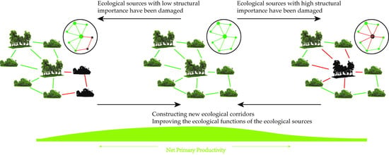
Graphical Abstract

1. Introduction

The issue of climate change resulting from greenhouse gas emissions is a pressing concern for humanity. The emission of greenhouse gases into the atmosphere has noticeably increased since the 1960s, with the majority of these emissions arising from the combustion of fossil fuels [1]. The growing human population is putting an increasingly heavy strain on land-based ecosystems, leading to heightened demand for natural resources such as food, fuel, and fibers and resulting in unsustainable land use practices, including over-cultivation, overgrazing, and deforestation [2]. These practices have further exacerbated the issue by increasing greenhouse gas emissions and decreasing their absorption, leading to a marked rise in global surface temperatures. This phenomenon not only causes localized natural disasters such as high temperatures and heat waves but also threatens the habitats of wildlife and exacerbates the spread of viruses, compromising human living conditions [3,4]. The high-intensity utilization of natural resources, brought about by factors such as population growth and rapid economic development, has made the ecological environment of many regions in China fragile, with widespread damage to forest and grass vegetation and a decline in the carbon sequestration capacity of ecosystems, particularly in the ESAMRYR in northern China [5,6]. As a result, understanding the current status of the regional structure of forest and grass vegetation, restoring and enhancing ecosystems, and devising effective strategies to enhance carbon sequestration function have become pressing priorities that must be addressed.
The solution to the core problem of imbalanced carbon sources and sinks is to reduce carbon sources and increase carbon sinks [7]. Reducing carbon sources in the short term is a huge challenge, as China’s energy consumption structure is high in carbon emissions and still in the phase of increasing emissions, requiring measures, such as energy conservation and emission reduction, energy substitution, etc., to achieve a carbon peak [8,9]. Increasing carbon sinks, on the other hand, is a solution that runs through the entire process of achieving the goal and is the focus of resolving the imbalance between carbon sources and sinks during the current period when the carbon peak target has not yet been achieved [10]. Forest and grass vegetation in ecological systems are a huge and natural carbon sink pool, constantly undergoing a carbon cycle between vegetation, soil, and the atmosphere, absorbing carbon from the atmosphere and fixing it in vegetation and soil through plant photosynthesis [11,12]. Forests are the largest carbon repository in land ecosystems and can serve as a carbon sink for up to 200 years, reaching a peak at 30–40 years of age; grasslands are the world’s most widely distributed land ecosystems, with organic carbon mainly stored in the soil, about 13.5 times that of the vegetation layer [13]. Therefore, increasing carbon sinks requires increasing forest and grass vegetation and improving their spatial distribution structure.
The ecological spatial network is a potent method for studying forest and grass vegetation structure. The ecological network consists of ecological patches and corridors, through which energy and matter move in the network, connecting all ecological patches. Currently, scholars are conducting research on the spatial structure of ecological systems, the protection of ecological functions and processes, and the coupling of ecological system services based on their respective research fields [14]. However, the common goal of research is to maintain the function of the ecosystem as a means of promoting the conservation of species and habitats and to promote the sustainable use of natural resources to reduce the impact of human activities on biodiversity [15,16]. The same characteristics of the network include providing connectivity to ensure that critical areas are buffered from potential destructive activities and restoring degraded ecosystems under appropriate conditions. Research methods mainly include landscape connectivity indices and model simulations, including: (1) the index method, which focuses on the relationship between patches; (2) graph theory, which graphically describes and expresses ecological patches and corridors, focusing on the ecological processes that occur between them; (3) cost-distance method, which focuses on the impact of matrices on ecological processes and can determine corridors and strategic points; and (4) circuit theory, which better reflects the random walk characteristics of organisms in nature [17,18,19,20]. Considering the role of matrices in ecological processes such as species migration and diffusion, graph theory and the minimum cost-distance method can be combined to quantitatively analyze patches and corridors in ecological networks on a larger scale. However, ecological spatial networks are dynamic networks, and changes in the network structure caused by external environments can lead to changes in the ecological environment and ecosystem service functions. To evaluate the changes in the network structure, topological indices such as degree, clustering coefficient, and betweenness centrality in complex network theory are introduced to describe the ecological spatial network structure [21]. Through these network topological indices, the relationship between the ecological spatial network structure, ecological environment, and ecosystem service functions is explored, and feasible network optimization plans are proposed.
In this paper, our research objective is to optimize the topological characteristics of the ecological spatial network of forest and grass vegetation to enhance its carbon sequestration capacity by evaluating the topological and functional importance of ecological sources. We employed the TFCO model to comprehensively evaluate three functional indicators, namely, area, Normalized Differential Vegetation Index (NDVI), and carbon sequestration, and four topological indicators, namely, degree, betweenness, clustering coefficient, and nucleus, to optimize the structural stability and carbon sequestration capacity of the ecological spatial network using different optimization schemes. We analyzed the carbon sequestration capacity of the study area before and after network optimization to evaluate the optimization effect on carbon sequestration functionality. Furthermore, we simulated ecological disturbances using malicious and random network attacks to analyze the robustness of the ecological spatial network before optimization and evaluate the effect of structural optimization.

2. Material and Methods

2.1. Material

2.1.1. Study Area

The Midstream Ecologically Sensitive Area of the Yellow River is composed of 20 cities in 5 provinces and regions, including Gansu, Ningxia, Inner Mongolia, Shaanxi, and Shanxi, which are located between 27°55′ and 32°58′ east longitude (Figure 1). The study area encompasses a total area of 541,651.33 km2. It is located in the temperate semi-arid region and has a typical continental monsoon climate characterized by abundant solar energy resources, high accumulated temperature, large diurnal temperature range, low precipitation, and high evaporation [22]. The average annual temperature in the region ranges from 3.6 to 14.3 °C, with cold winters and warm summers, and the average annual precipitation ranges from 150 to 750 mm, mainly concentrated in July to September. The evaporation ranges from 1400 to 2000 mm, and the region is divided into three sub-regions, from northwest to southeast: arid, semi-arid, and semi-humid [23]. The water system in the study area is primarily composed of the Yellow River, with sand deserts on both sides of the upper reaches, few major tributaries, and relatively gentle water flow [24]. In the midstream, the region experiences frequent flash floods and forms numerous streams of runoff in the Loess Plateau region, accounting for over 70% of the annual water volume. The northwestern part of the ESAMRYR also contains the Ulanchabu and Tengger deserts, the Kubuqi Desert located on the southern bank of the Yellow River in the north, the Ordos Plateau rising from Ordos City in the central part, the Maoershan Desert at the junction of Ordos City and Yulin City, grasslands in the north of Bayan Nur and Baotou cities, and basin terrain in Shanxi Province in the east of the ESAMRYR [25].
The ESAMRYR is characterized by complex geomorphology and geology, as well as a fragile ecosystem. However, its location is of strategic importance. It houses China’s important energy strategic reserve bases and holds reserves of coal, coalbed methane, natural gas, and crude oil, accounting for 66.2%, 50%, 37.8%, and 7.5% of China’s total, respectively, and contributing 50% of China’s total energy output. Due to years of mining activities and unsustainable land use practices, compounded by the arid and desert-like conditions in the northwest and the loose soil and summer storms in the southeast, ecological restoration in the ESAMRYR presents a significant challenge. This is manifested in the increasing desertification in the northwest, serious ecological hazards in mining areas, a decrease in the quantity and quality of grasslands, severe soil erosion in the southeast, and a large amount of sediment flowing into the Yellow River. The ESAMRYR is a typical example of an ecosystem that is fragile and has a harsh ecological environment [26].

2.1.2. Data Sources and Processing

The data on land use and cover type (Land Use-Cover Change, LUCC) for the years 2000, 2010, and 2020 in the ESAMRYR is sourced from the Global Surface Cover Data GlobeLand30 (http://www.globallandcover.com/, accessed on 21 January 2023). The spatial resolution is 30 m and was derived from multiple spectral imagery such as Landsat’s TM5, ETM+, OLI, HJ-1, etc. The overall accuracy of the three datasets is 83.50%, 83.50%, and 85.72%, respectively, with Kappa coefficients of 0.78, 0.78, and 0.82. Data such as Digital Elevation Model (DEM), Slope (SLOPE), and NDVI were obtained via downloading from Google Earth Engine (https://developers.google.cn/earth-engine/, accessed on 25 January 2023). The Digital Elevation Model (DEM) data were sourced from the NASADEM dataset released by NASA in 2020 with a spatial resolution of 30 m. It was a re-processing of the 90 m spatial resolution STRM data, and its accuracy was improved by incorporating auxiliary data from the ASTER GDEM, ICESat GLAS, and PRISM datasets. The Slope data were obtained by using the method ee.terrain.slope in GEE on the DEM data. The Normalized Differential Vegetation Index (NDVI) data with a spatial resolution of 30 m were obtained through normalization calculation of the near-infrared and infrared bands in the Landsat TOA imagery collection. The time selection for the imagery collection was from early June to the end of September, and the collection fully covers the ESAMRYR with a low cloud amount of less than 10%. The NDVI data for the years 2000 and 2010 were calculated using Landsat-7 imagery, while the NDVI data for 2020 were calculated using Landsat-8 imagery. The road and water vector data were sourced from OpenStreetMap (http://www.openstreetmap.org/, accessed on 25 January 2023), and the spatial resolution of 30 m for the road network density data and water network density data was obtained through line density analysis in ArcGIS. The land cover type data and monthly NDVI data were obtained via Google Earth Engine (GEE). Meteorological data were sourced from the China Meteorological Administration’s Meteorological Data Center (http://data.cma.cn, accessed on 2 February 2023). The ESAMRYR includes 53 weather stations, and the temperature, precipitation, and daily sunshine hours were interpolated spatially using the meteorological interpolation software ANUSPLIN based on the longitude, latitude, and elevation of each weather station.

2.1.3. Remote Sensing Data Acquisition and Processing

To obtain a more accurate estimation of the carbon sink using Theoretical Model of Photonic Energy Utilization Efficiency, we computed annual average NDVI, monthly average NDVI, land cover type data, and fraction of photosynthetically active radiation (FPAR) using MODIS and Landsat. The annual average NDVI and MNDWI were used to construct the ecological spatial network of the study area, while the monthly average NDVI and FPAR were used to calculate NPP. The NDVI data for 2000 and 2010 were calculated using Landsat-7 imagery, while the NDVI data for 2020 were calculated using Landsat-8 imagery. The Landsat imagery has seven bands (B1 to B7). After radiometric calibration, atmospheric correction, and geometric correction, we used the following formula to calculate NDVI for Landsat-7 data:
N D V I = ( B 4 B 3 ) ( B 4 + B 3 )
Here, B 4 and B 3 represent the reflectance of bands 4 and 3, respectively, of Landsat-7 data.
For Landsat-8 data, we used the following formula to calculate NDVI:
N D V I = ( B 5 B 4 ) ( B 5 + B 4 )
Here, B 4 and B 5 represent the reflectance of bands 4 and 5, respectively, of Landsat-8 data.
The land cover type data and monthly NDVI data were obtained by downloading from GEE, sourced respectively from the MODIS land cover product MCD12Q1 and the vegetation index data product MOD13A1, both with a spatial resolution of 500 m. The MCD12Q1 product was generated through supervised classification of MODIS Terra and Aqua reflectance data, according to the classification system developed by IGBP, and includes 17 major land cover types. The MOD13A1 product was calculated from atmospherically corrected bidirectional surface reflectance data, with water, clouds, heavy aerosols, and cloud shadows masked [27].
The FPAR used in calculating NPP in the study area was obtained through MODIS product processing. After obtaining monthly average NDVI from the MODIS MOD13A1 product, FPAR was calculated using the following formula:
F P A R ( x , t ) = ( F P A R ( x , t ) N D V I + F P A R ( x , t ) S R V I ) / 2
F P A R ( x , t ) N D V I = [ N D V I ( x , t ) N D V I i , m i n ] × ( F P A R m a x F P A R m i n ) N D V I i , m a x N D V I i , m i n + F P A R m i n
F P A R ( x , t ) S R V I = [ S R V I ( x , t ) S R V I i , m i n ] × ( F P A R m a x F P A R m i n ) S R V I i , m a x S R V I i , m i n + F P A R m i n
The equation is defined as follows: F P A R ( x , t ) represents the FPAR absorbed by vegetation at point x in month t, where F P A R m a x (=0.95) and F P A R m i n (=0.001) are independent parameters; N D V I ( x , t ) represents the NDVI at point x in month t, where N D V I i , m i n is a fixed value of 0.023; and S R V I ( x , t ) represents the sample ratio vegetation index (SRVI) at point x in month t, where S R V I i , m i n is a fixed value of 1.05.
S R V I ( x , t ) = ( N D V I ( x , t ) + 1 ) / ( 1 N D V I ( x , t ) )
ε ( x , t ) = f t ( x , t ) × f w ( x , t ) × ε m a x ( x , t )
f t ( x , t ) = T ε 1 ( x , t ) × T ε 2 ( x , t )
T ε 1 ( x , t ) = 0.8 + 0.02 × T o p t ( x , t ) 0.0005 × [ T o p t ( x , t ) ] 2
T ε 2 ( x , t ) = 1.184 / ( 1 + exp [ 0.2 × ( T o p t ( x , t ) 10 T ( x , t ) ) ] ) × 1 / ( 1 + exp [ 0.3 × ( T ( x , t ) T o p t ( x , t ) 10 ) ] )
f w ( x , t ) = 0.5 + 0.5 × ( E E T ( x , t ) / P E T ( x , t ) )
In the equation, f t ( x , t ) represents the temperature effect factor, which reflects the impact of extreme high or low temperatures on plant photosynthetic energy use efficiency. T o p t ( x , t ) is the optimal temperature; T ( x , t ) is the actual temperature at point x in month t; f w ( x , t ) is the water effect factor; E E T ( x , t ) is the actual evapotranspiration (mm); PET(x,t) is the potential evapotranspiration (mm); and ε m a x ( x , t ) is the maximum photosynthetic energy use efficiency ( gC · MJ 1 ) under ideal conditions at point x.

2.2. Establishment of the Ecological Spatial Network

2.2.1. Extraction of Ecological Sources

Ecological sources are the core regions with the highest concentration of nutrients, water, and information and are also the origins of ecological energy and species dispersal, providing abundant ecosystem services to surrounding ecosystems. In such dry and semi-arid and semi-humid regions within the ESAMRYR, the forest–grass vegetation structure plays a crucial role in ecosystem and ecological carbon sink function. The ecological source, which is represented by the clustered sources of forests and grasslands, serves as a basic constituent unit of the forest and grass vegetation structure [28].
The MSPA is a method of image processing that uses geometric concepts to measure, recognize, and segment gridded images. It describes the geometric shape and connectivity of an image [29]. The MSPA analysis divides the foreground region of a binary image into seven visually distinct classes, such as core, islet, edge, etc. The core region refers to the collection of foreground pixels that are a certain distance away from the background pixels and represents large-scale natural sources [30]. In this study, the forest, grassland, and shrubland in the ESAMRYR’s land cover types were set as the foreground data, while other types were set as background data. Then, Guido’s Toolbox was used to perform MSPA analysis on the grasslands and forests of 2000, 2010, and 2020 using eight-neighborhood analysis. The core region in the analysis results represents the initial ecological source.
The area covered by grasslands and shrublands in the study region is relatively high and widely distributed, whereas the forest land area is relatively low and more concentrated in the southeastern part of the study region. Therefore, based on the difference in area and distribution, different area thresholds are set for the MSPA analysis results to determine the ecological sources in the study region. The area threshold for grasslands and shrublands is 500 km2, while that for forest lands is 50 km2.

2.2.2. Identification of Ecological Corridors Using MCR Model

An eco-corridor is a comprehensive pathway for ecological processes between ecological sources, with ecological processes being impeded by various types of obstacles during transmission. The ecological corridor is generally the path with the least resistance between ecological sources. The MCR model refers to the cost or work required to move and transfer species and energy from the source area to the destination, passing through land units with different resistance values [31]. The resistance value reflects the connectivity of the land unit to the source area, with a smaller resistance value indicating that the ecological process is more easily carried out, while a higher resistance value indicates that the ecological process is less easily carried out, with the expression being:
M C R = f m i n b = n a = m D a b × R a
In the formula, Dab represents the spatial distance from source b to land unit a; Ra represents the composite resistance of land unit a to the direction of the ecological process; and f represents the positive correlation between the minimum cumulative resistance and the ecological process.
An ecological corridor is not only a low-value area formed between two source areas but is also the easiest area for the connection between the two sources. By importing the ecological sources and the composite ecological resistance surface into the Graphab software, the ecological corridor calculated based on the minimum cost path between the ecological sources can be extracted, thus recognizing the ecological spatial network in the ESAMRYR at different periods [32].

2.2.3. Topological Analysis of Ecological Spatial Networks

The forest–grass vegetation structure can be abstracted as a network when the ecological sources are abstracted as nodes and the ecological corridors between sources are abstracted as edges. The characteristics that can be represented without relying on the specific location of the nodes and the specific form of the edges are the topological characteristics of the network. The analysis of the topological structure of the network can be used to express the intrinsic relationships between the ecological sources and the connectivity of the entire forest–grass vegetation. This study, based on the theory of complex networks, selects the degree and degree distribution, average path length, clustering coefficient, betweenness, core degree, and other indicators to analyze the topological structure of the network (Table 1) [33].
The amount of vegetation carbon sequestration is dependent on the number, type, and growth status of vegetation present in ecological sources. Consequently, regulating the number and growth status of vegetation in these sources can be used to adjust their carbon sequestration capacity. Vegetation quantity and growth status are largely influenced by water and nutrient availability in ecological sources, and the circulation of these substances is influenced by the landscape’s spatial structure. Ecological corridors serve as conduits for information transmission, substance circulation, and energy flow among different sources. By optimizing the ecological corridors and changing the topological properties of the material and energy flow channels in the ecological spatial network, it is possible to alter the vegetation carbon sequestration capacity of different sources.

2.3. Estimating the Carbon Sink of the Ecosystem Using Theoretical Model of Photonic Energy Utilization Efficiency

2.3.1. Theoretical Model of Photonic Energy Utilization Efficiency

Net Primary Productivity (NPP) refers to the net organic carbon production of vegetation within an ecosystem, which constitutes the total annual above-ground and below-ground growth after subtracting the respiration consumed by the plants themselves [38]. Its basic principle is to estimate the net growth of vegetation based on differences in the acquisition of solar radiation and utilization of light energy by vegetation, and its estimation formula is:
N P P ( x , t ) = P A R ( x , t ) × F P A R ( x , t ) × ε ( x , t )
The formula NPP(x, t) represents the net primary productivity at point x for the month t. PAR(x, t) represents the photosynthetically active radiation at point x for the month t, which is typically 50% of the total solar radiation in the ESAMRYR. FPAR(x, t) represents the proportion of photosynthetically active radiation absorbed by vegetation at point x for the month t. ε(x, t) represents the actual light energy use efficiency (ALEUE) at point x for the month t.
However, there are still some limitations in the CASA model, such as the lack of consideration of the impact of vegetation cover classification accuracy on the estimation results. The global vegetation maximum photosynthetic utilization rate of 0.389 gC/MJ (grams of carbon per megajoule) is not appropriate, and the soil molecular model used to estimate the water stress factor is complex and difficult to obtain with many soil parameters [39]. An improved vegetation NPP estimation system was developed based on the CASA model, which added vegetation cover classification and considered classification accuracy to determine the photosynthetic radiation absorption ratio of each vegetation type. The model also simulated the maximum photosynthetic utilization rate of the main vegetation types in China and replaced the soil molecular model with a regional evapotranspiration model. According to the vegetation type in the ESAMRYR, the maximum photosynthetic utilization rate is shown in the table (Table 2), and the maximum and minimum NDVI values of each vegetation type are automatically generated by inputting the vegetation type map, the annual NDVI maximum value, and the overall classification accuracy of the vegetation type map. Solar radiation stations are scarce, so total solar radiation is converted from sunshine hours, which is based on the working hours of solar components under standard conditions, and 1 h of sunshine corresponds to 3.6 MJ/m2 (energy received per unit area) of solar radiation.

2.3.2. Ecosystem Carbon Sink Estimation

The carbon sink function of vegetation is realized through photosynthesis. Therefore, the total carbon sequestration of vegetation can be estimated using photosynthesis equation. The photosynthesis equation of plants is as follows:
C O 2 ( 264 g ) + H 2 O ( 108 g ) C 6 H O ( 180 g ) + O 2 ( 192 g ) ( C 6 H 10 O 5 ) n ( 162 g )
Hence, it can be deduced that 1.63 g CO2 is required to fix 1 g of polysaccharides through photosynthesis by plants [40]. The produced polysaccharides, which represent the dry matter produced by plants, are referred to as plant biomass in ecology [41].
G =   ( 1.63 × R c × N P P )
In the equation, G represents the total carbon sequestered by the vegetation in a region; Rc represents the carbon content in CO2, which is 27.27%; NPP represents the per unit area net primary productivity of vegetation.

2.4. Topology and Function Coupling Optimization Model

The topological structure of the ecological space network is used to characterize the structure of forest and grassland vegetation, including node degree, clustering coefficient, betweenness, and coreness, which reflect the connectivity characteristics of the network and the importance of nodes in the connectivity process [42]. From an ecological perspective, the carbon sink function of forest and grassland vegetation depends on the underlying ecological characteristics of each ecological source, such as area, carbon storage, and vegetation coverage. When both structure and function are considered simultaneously, the coupling problem between the two arises. When the topological and functional importance match, structure and function are synergistic. Conversely, when they don’t match, there is a mismatch between structure and function. This mismatch can be divided into two cases: one is that the underlying ecological source is good, but its importance is low in the network connectivity, and the functional importance is greater than the topological importance; the other is that the ecological node is important in the network connectivity, but the underlying ecological source conditions are poor, and the topological importance is greater than the functional importance. Different strategies need to be developed to improve and optimize according to different situations.
In order to assess the topological and functional coherence of various ecological sources, it is necessary to establish an evaluation system. For topological importance, four indices are utilized for comprehensive evaluation, including degree, betweenness, clustering coefficient, and core number. For functional importance, three indices are utilized for comprehensive evaluation, including area, vegetation coverage, and carbon sequestration. The specific algorithms are as follows:
T I S i = ( D i D m i n D m a x D m i n + B i B m i n B m a x B m i n + C i C m i n C m a x C m i n + C o i C o m i n C o m a x C o m i n ) / 4
F I S i = ( S i S m i n S m a x S m i n + N D V I i N D V I m i n N D V I m a x N D V I m i n + G i G m i n G m a x G m i n ) / 3
In the equation, TISi represents the topological importance of ecological node i; Di, Bi, Ci, and Coi represent the degree, betweenness, clustering coefficient, and core number of ecological node i, respectively; FISi represents the functional importance of ecological source i; Si, NDVIi, and Gi represent the area, vegetation coverage, and carbon storage of ecological source i, respectively; max and min represent the maximum and minimum values of each index among all nodes in the network.
The topological and functional synergies among various ecosystems can be evaluated based on the following formula:
S y i = T i F i
where in Syi represents the topological and functional synergy of ecosystem I; Syi < 1 implies that functional importance is greater than topological importance; Syi > 1 implies that topological importance is greater than functional importance; and Syi = 1 implies that structure and function are synergistic.
The topological and functional significance of ecosystems have been shown to be interdependent, with both components contributing to the stability and efficacy of vegetation spatial structures. Ecosystems in which both topological and functional significance are high are expected to demonstrate the highest degree of stability and ecological carbon sequestration capacity. Conversely, ecosystems characterized by low functional significance may require increased investment in conservation and construction efforts. On the other hand, ecosystems with low topological significance may benefit from increased connectivity among their constituent nodes. In light of this, the TFCO model is proposed as a means of assessing the status of various ecosystems within the ESAMRYR’s forest–grass vegetation and of formulating corresponding optimization strategies (Figure 2).

3. Results

3.1. Analysis of Ecological Space Network

3.1.1. Ecological Source

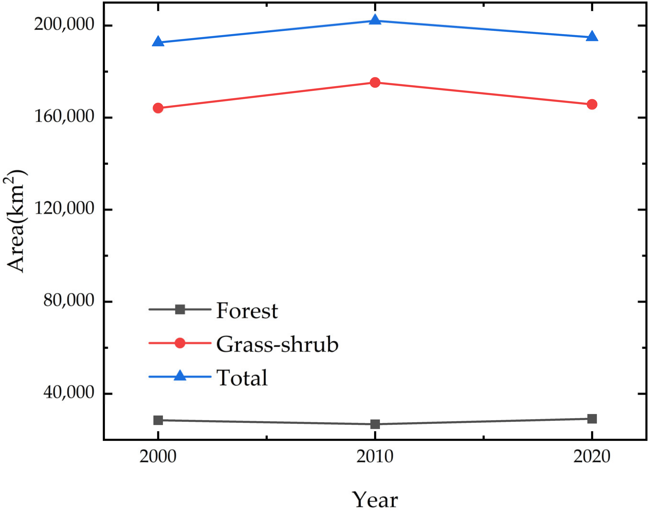
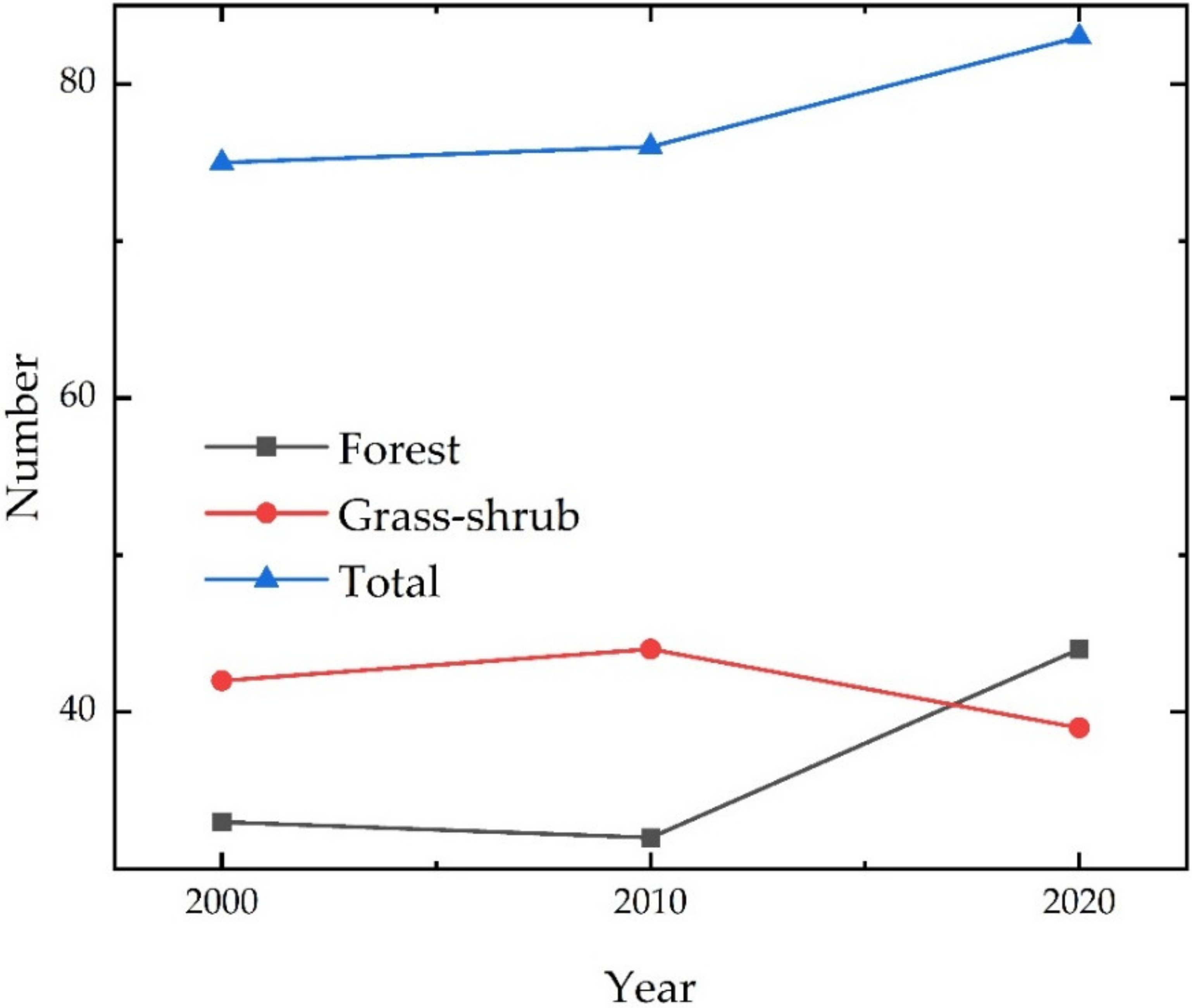
The analysis of the evolution of the ecological source in the ESAMRYR from 2000 to 2020 reveals that the total area of the ecological source was 192,619.80 km2 in 2000, increased to 202,077.28 km2 in 2010, and then decreased to 194,910.12 km2 in 2020. The majority of the ecological source, accounting for over 85%, consists of grass–shrublands, while the remaining, approximately 15%, constitutes forest lands (Figure 3). Between 2000 and 2020, the number of grassland and shrubland source areas remained around 40, with an initial increase followed by a subsequent decrease. The area of these source areas initially increased and then decreased, but the average area continued to increase. On the other hand, the number of forest lands increased significantly in the latter stage while remaining relatively stable in the earlier stage, and the total area of forest lands decreased first and then increased, with a continuously decreasing average area (Figure 4). This suggests that the grass–shrublands were relatively stable, with some merging of sources, and had a tendency to cluster, while the forest lands had new smaller sources joining, leading to an increase in their number and a decrease in their average area.

3.1.2. Analysis of Ecological Resistance

The ESAMRYR’s ecological resistance factors are analyzed based on the land cover type, elevation, slope, vegetation coverage, water network density, and road network density. Each resistance factor is classified and weighted to generate a composite ecological resistance surface for the ESAMRYR (Figure 5). The composite ecological resistance value for the ESAMRYR ranges between 1.00 to 27.33, with the highest ecological resistance found in the desert areas in the northwest corner of the ESAMRYR, specifically the Kubuqi Desert and the Maowusu Sands, where the high ecological resistance areas form clusters. The highest ecological resistance in the Maowusu Sands occurs in its alkali soils. The surrounding areas have slightly lower resistance. Areas with higher road network density in urban areas have higher ecological resistance, while surrounding areas gradually decrease in resistance. Next, the southwestern bare land, cultivated land, and grassland are interspersed regions of the ESAMRYR, which have lower vegetation coverage and slightly higher ecological resistance. The grassland regions in the central and northern parts of the ESAMRYR and the cultivated land regions in the river valley have lower ecological resistance. The regions with the lowest ecological resistance are the forest areas in the southeast part of the ESAMRYR and areas with high water-network density. Between 2000 and 2020, with the expansion of grassland and forest area and the increase in vegetation coverage, the low-resistance ecological areas showed a trend of expansion, and the expansion of high-resistance ecological areas occurred in areas of artificial surface expansion. Between 2000 and 2010, the reduction in ecological resistance mainly occurred in the grassland and forest distribution boundary areas on the east side of the ESAMRYR and the grassland area in Bayan Nur City. Between 2010 and 2020, the reduction in ecological resistance occurred in the grassland and forest distribution boundary areas on the south side of the ESAMRYR, and there was also a certain degree of reduction in the ecological resistance of the central grassland in the ESAMRYR.

3.1.3. Analysis of Ecological Spatial Network

A network structure diagram of the forest–grass vegetation structure in the ESAMRYR was constructed using the Graphab software based on graph theory and the minimum cost distance method was employed to analyze the network connectivity. The ESAMRYR’s ecological sources were numbered consecutively, and the minimum cost paths passing through the comprehensive ecological resistance surface from each ecological source generated the ecological corridors in the ESAMRYR, resulting in the construction of the ESAMRYR’s ecological spatial network (Figure 6). In 2000, 75 ecological sources were connected by 189 ecological corridors, while in 2010, 76 ecological sources were connected by 196 ecological corridors, and in 2020, 83 ecological sources were connected by 212 ecological corridors. In the ecological spatial network, grassland patch areas were large and widely distributed, with slightly higher comprehensive ecological resistance in surrounding areas, while forest patch areas were smaller and more dispersed, with low ecological resistance. Therefore, the majority of ecological corridors were distributed in the eastern and southern parts of the ESAMRYR. The ecological corridors in the northern and western parts were also distributed near the east and south, and there was essentially no distribution of ecological corridors in the northwest. The distance between grassland patch blocks was close, with short ecological corridors, while the distance between forest patch blocks was slightly further, with longer ecological corridors. From 2000 to 2020, the number of ecological corridors gradually increased, especially between grassland patch blocks in the northwest of the ESAMRYR, as well as in the forest areas of Lüliang Mountain in Xinzhou City in the eastern part of the ESAMRYR, and in the ecological corridors in Guyuan City in the southwestern part of the ESAMRYR. In these areas, the patch blocks expanded, and the ecological resistance decreased, making ecological processes easier to occur.

3.2. The Spatial Topological Characteristics of the Ecological Spatial Network

The connection situation of the ecological corridors to the ecological sources was abstracted as an adjacency matrix, and the ForceAtlas2 algorithm in the complex network visualization software Gephi was selected to layout the cluster relationships of the various ecological sources in the ESAMRYR (Figure 7). The results showed that in the ecological space networks in the three periods of 2000, 2010, and 2020, there was an ecological source with the highest degree value and the most obvious cluster relationship, respectively, 74, 76, and 83. Combining with Figure 7, it can be seen that these three ecological sources are all located in the largest grassland ecological source in the center of the ESAMRYR, and the majority of the ecological sources are surrounded by this ecological source and connected to it. Secondly, the 29, 45, and 47 ecological sources in the 2000 ecological space network have a higher degree value and are located in the Lüliang mountain area in the east of the ESAMRYR from south to north. In the 2010 ecological space network, the 34, 46, and 74 ecological sources have a higher degree value, with the first two in the same position as the 29 and 45 in the 2000 ecological space network, and the 74th is a forest source land located in Huanglong Mountain. In the 2020 ecological space network, the 62 ecological source has a higher degree value and is in the same position as the 45 and 46 in the previous two periods. These ecological sources form small clusters with the surrounding source lands, making them bridges connecting other blocks. In addition, the connection relationship of most of the ecological sources in the three periods of the ecological space network is relatively small, but relatively speaking, there are more cases where the ecological sources connected to several high degree value forest blocks are also connected to each other, indicating that these blocks have more communication and are mainly located on the east side of the ESAMRYR. Although the ecological sources in the north, west, and south of the ESAMRYR are basically connected to the central grassland block, their connections are relatively few.

3.3. Topological Characteristics of the Ecological Spatial Network

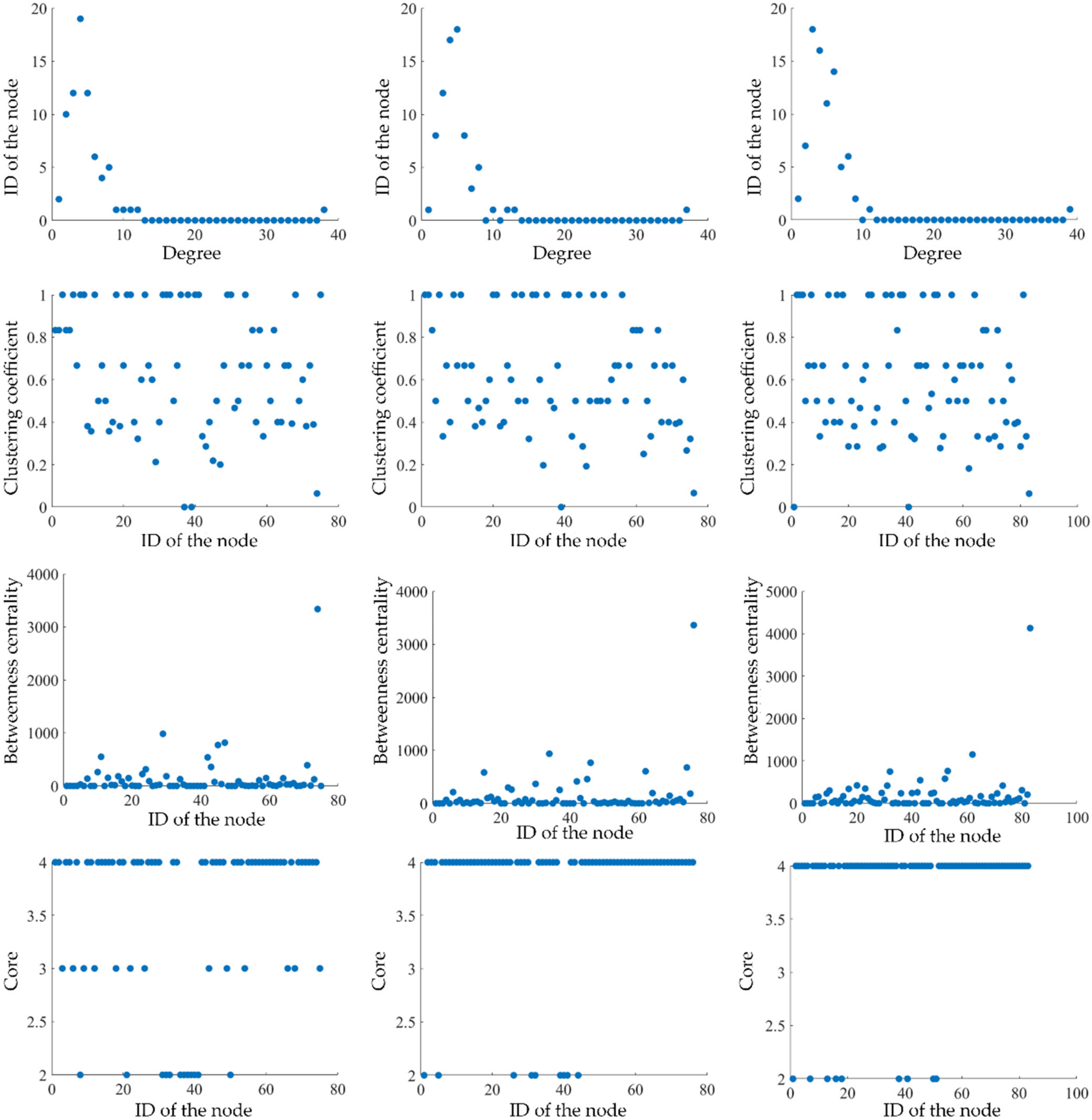
The results of the topological analysis of the ecosystem space network (Figure 8) show that the average path lengths between nodes in the network for the years 2000, 2010, and 2020 were 2.90, 2.90, and 3.07, respectively, indicating that any two nodes in the network are on average connected through three ecological corridors. The network diameters were 6, 6, and 7, respectively. The degree distributions of the network all exhibit power law distributions, indicating that the network is a scale-free network with severe heterogeneity, where a few nodes have many connections, while the majority of nodes have very few connections. Scale-free networks are robust to random attacks, but when subjected to malicious attacks, a small number of high-degree nodes being damaged can quickly lead to network paralysis. In the 2000 network, nearly 73.33% of the nodes had degrees of 6 or less, with 4 nodes having degrees of 10 or more (10, 11, 12, and 38), and 6, 4, 5, and 1 nodes having degrees of 6 to 9, respectively. In the 2010 network, 73.68% of the nodes had degrees of 6 or less, with 4 nodes having degrees of 10 or more (10, 12, 13, and 37), and 8, 3, 5, and 1 nodes having degrees of 6 to 9, respectively. In the 2020 network, 65.06% of the nodes had degrees of 6 or less, with 2 nodes having degrees of 10 or more (11 and 39), and 14, 5, 6, and 2 nodes having degrees of 6 to 9, respectively. The decrease in the proportion of low-degree nodes means that the number of nodes with increased degrees is increasing, and the differences in node connections are gradually shrinking.
The average values of the clustering coefficients of the nodes in the network in three periods are 0.64, 0.62, and 0.60, respectively. The proportion of nodes with a clustering coefficient of 1 among all nodes is 28%, 24%, and 23%, respectively. There are 2, 1, and 2 nodes with a clustering coefficient of 0, respectively. The proportion of nodes with a clustering coefficient greater than or equal to 0.67 is 53.33%, 46.05%, and 45.78%, respectively. This indicates that the concentration of ecological sources is relatively high in the ESAMRYR, mainly located in the eastern and southern parts of the ESAMRYR. However, the clustering coefficient of nodes has decreased over the 20-year period, mainly in the forest blocks in the eastern Lüliang Mountains and the grass–shrub blocks in the western Helan Mountains. This may be related to the increase in the number of neighboring nodes caused by the increase in small areas of ecological sources in these areas. In the three periods of the network, most of the nodes have a low betweenness centrality, while a few have a high betweenness centrality. The average betweenness centrality values were 143.49, 146.45, and 180.87, respectively, and the maximum values were 3336.41, 3361.49, and 4130.30, respectively, all in the central grassland block. In 2020, the number of nodes with betweenness centrality between 200 and 500 increased significantly compared to the first two periods, mainly in the blocks near the high betweenness centrality nodes in the east and the grassland blocks in the north. The decrease of low betweenness centrality nodes, the increase of intermediate betweenness centrality nodes, and the unchanged high betweenness centrality nodes indicate a gradual reduction of node differentiation, and the biggest changes occurred in the network in 2020. As the central grassland blocks, which serve as the connecting skeletons of the network, are of greater importance, they require more attention and protection. The average coreness for the three time periods is 4, and the proportion of nodes with a coreness of 4 in the network is 66.67%, 88.16%, and 89.16%, respectively. In 2010 and 2020, the rest of the nodes in the network have a coreness of 2, and in 2000, there were still 13 nodes with a coreness of 3. The decrease in the number of nodes with low coreness and the gradual decrease in area indicate that the connections between nodes in the ecological space network are becoming more numerous and that more nodes are entering the inner layer of the network. The ecological sources outside the network are basically distributed around the central grass–shrubland patch.
The degree distributions of the networks in the three periods all exhibit power-law distribution characteristics, with the network belonging to a scale-free network and exhibiting serious heterogeneity. Most of the nodes in the three networks have low betweenness centrality, and a few nodes have high betweenness centrality. The number of nodes with low betweenness centrality decreased, the number of nodes with intermediate betweenness centrality increased, and the number of nodes with high betweenness centrality remained relatively unchanged, indicating that the differences among the nodes gradually decreased. The number of nodes with low coreness decreased, and the area decreased, indicating that the connections among nodes increased and that more nodes entered the inner layer of the network, with the outer blocks mainly distributed around the central grassland blocks.

3.4. Carbon Sink Analysis of Ecosystem

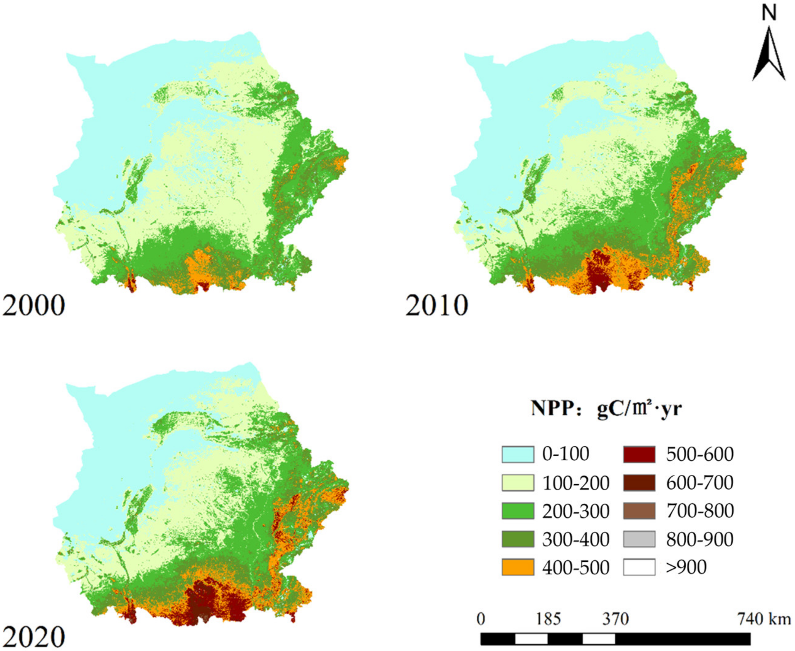
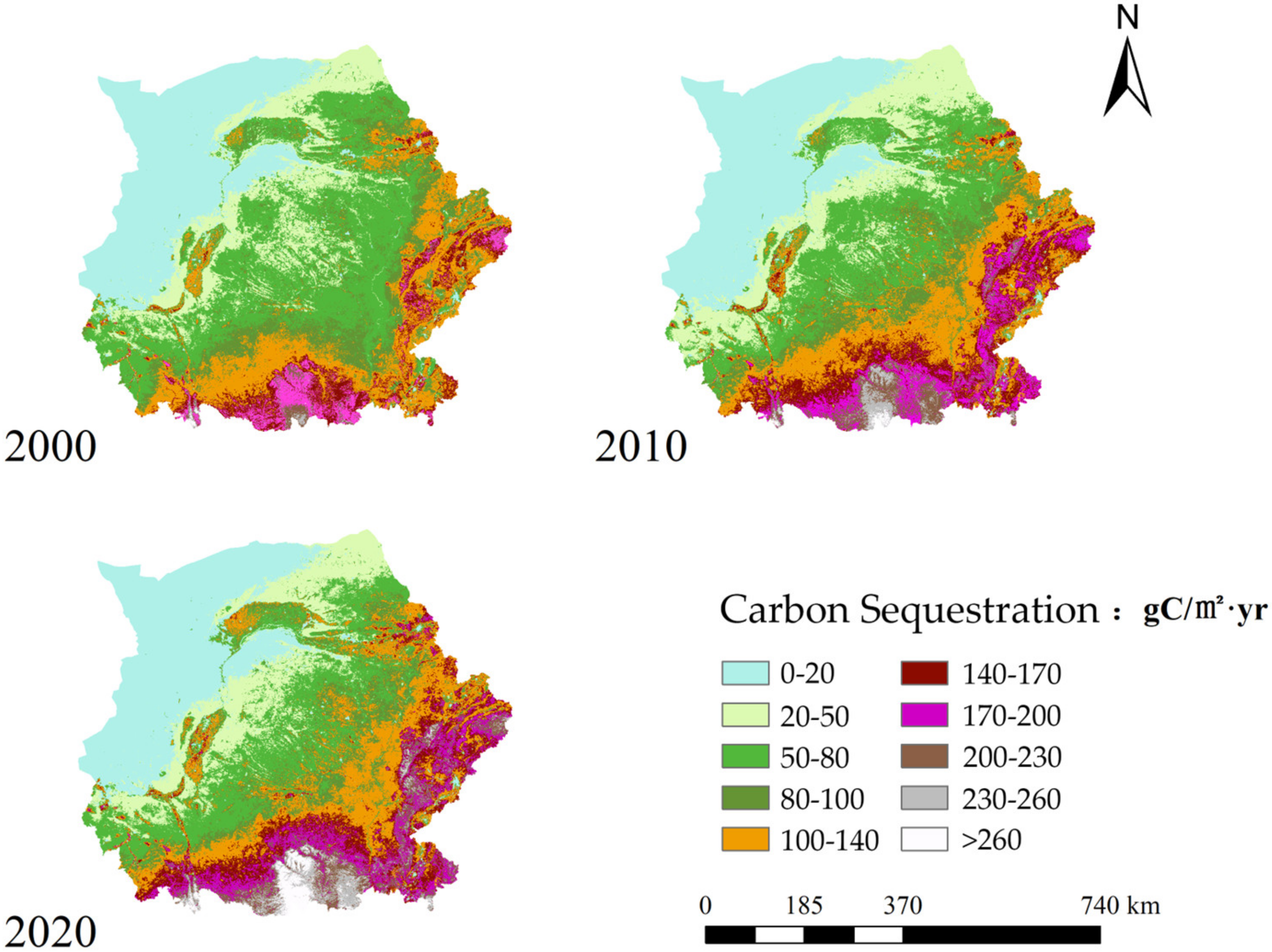
In this study, the NPP of the ESAMRYR was calculated (Figure 9), and the resulting carbon sequestration was determined (Figure 10). The distribution of carbon sequestration in the years 2000, 2010, and 2020 was found to be primarily concentrated between 19 and 161 gC/m2·yr, between 20 and 182 gC/m2·yr, and between 21 and 200 gC/m2·yr, respectively. An analysis of the spatial distribution of carbon sequestration in the year 2000 revealed that most regions had a carbon sequestration below 80 gC/m2·yr, with higher values (above 100 gC/m2·yr) being primarily located in the southern and eastern regions of the ESAMRYR. The highest values (above 200 gC/m2·yr) were observed only in the southernmost regions, specifically the Sub-Himalayan region. In 2010, the regions with a carbon sequestration above 100 gC/m2·yr expanded towards the northwest but remained primarily located in the southeast. No significant changes were observed in the western and northern regions, with the exception of a slight increase in carbon sequestration in the central regions of the Ordos Plateau and a decrease in Baotou City. On the whole, the regions with the highest carbon sequestration rates are those with forest distributions in the southern and eastern parts of the ESAMRYR, followed by the Ningxia Plain and Hohhot City. The carbon sequestration rates in grassland areas with large-scale coverage in the central part of the ESAMRYR are higher in the southeast and lower in the northwest, in accordance with the distribution trend of vegetation coverage because of the higher rainfall in the southeast, which results in better growth of herbaceous vegetation. Over the course of 20 years, the high carbon sequestration rate regions in the ESAMRYR have spread to the northwest, and most areas have increased their carbon sequestration rate, especially in the southeast regions, where the increase in carbon sequestration rate mainly occurred between 2000 and 2010. Besides this region, the carbon sequestration rate in the northern regions of the ESAMRYR has also significantly increased in the 2010–2020 period, indicating that the ecological construction and natural growth of vegetation over the course of 20 years have led to an increase in carbon sequestration rate in more areas.
The total amount of carbon sequestered in the ESAMRYR is estimated based on the type of land cover, and the results are presented in Table 3. Overall, the highest carbon sequestration was observed in grassland, followed by cultivated land and forest, while the lowest was in shrubland, which is consistent with the order of area coverage of land types. However, there was some discrepancy between the area and carbon sequestration of the four types of land cover. The grassland covered approximately 55% of the area and sequestered around 40% of carbon, while cultivated land covered around 33% of the area and sequestered 37% of carbon. Forest covered approximately 10% of the area and sequestered 20% of carbon, and shrubland covered about 1.5% of the area and sequestered about 1% of carbon. This indicates that despite its smaller area, the forest has higher NPP (net primary productivity) and therefore a greater carbon sequestration rate, reaching twice the rate of area coverage. The cultivated land also has a relatively high NPP, and its carbon sequestration rate exceeds the rate of area coverage. Conversely, the grassland NPP is relatively low, particularly in the northwestern region of the ESAMRYR, and its carbon sequestration rate is much lower than the rate of area coverage. The shrubland’s carbon sequestration rate is slightly lower than the rate of area coverage.
When comparing the carbon sequestration between 2000, 2010, and 2020, it was observed that the total carbon sequestration of all four land cover types has increased annually and that the rate of increase was higher in the 2010–2020 period than in the 2000–2010 period. The cultivated land showed the highest increase, followed by the forest, grassland, and shrubland. However, in terms of proportion, only the forest continued to increase, while cultivated land first decreased and then increased. Shrubland increased first and then decreased, and grassland decreased continuously. This highlights the importance of grassland, which is the largest area in the ESAMRYR, as the main contributor to carbon sequestration, and the significance of the forest in enhancing carbon sequestration.

3.5. Analysis and Optimization of the TFCO Model

3.5.1. Functional Importance of Ecological Sources

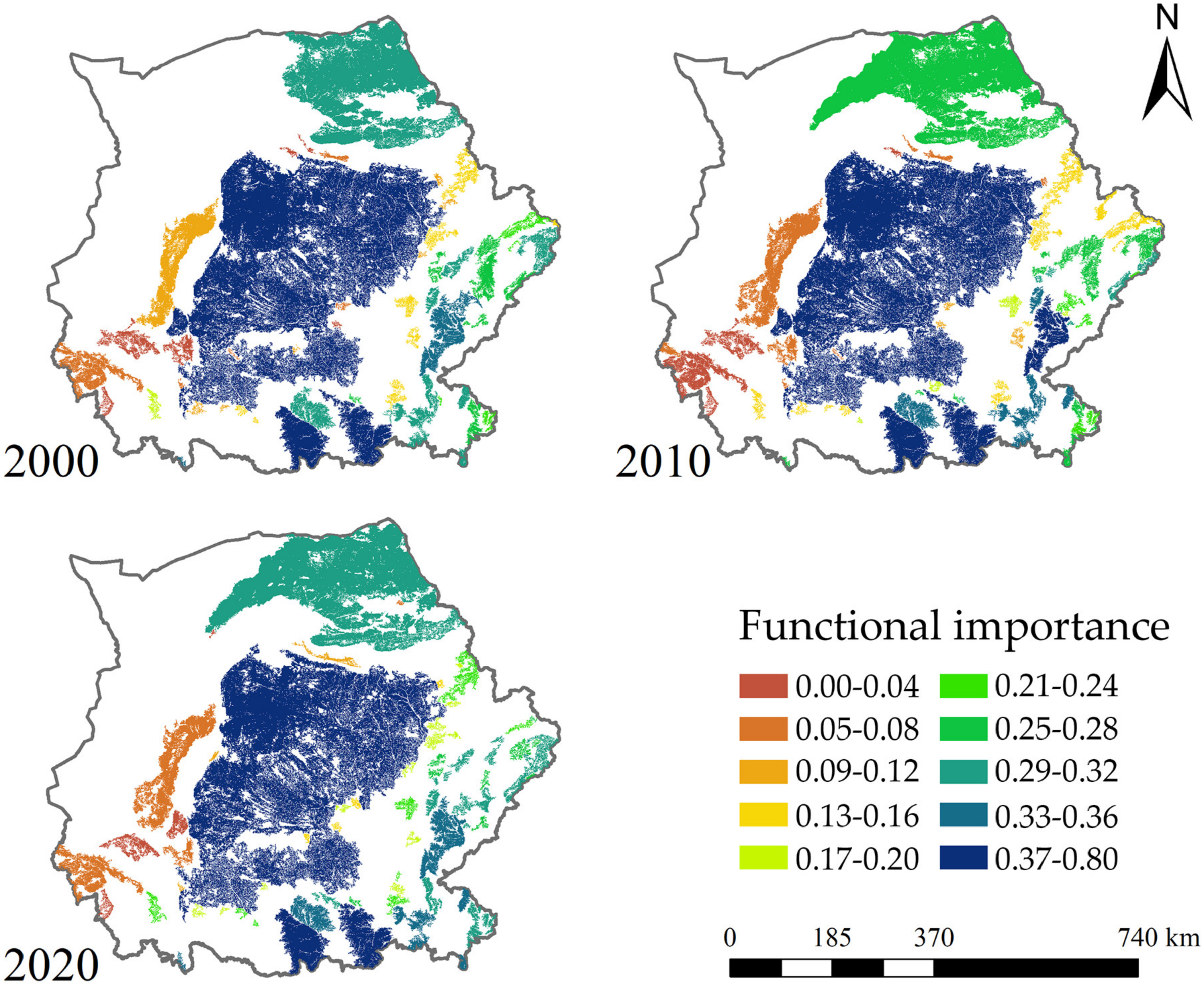
The functional importance of various ecological sources in the ESAMRYR was evaluated based on three indicators: area, NDVI, and carbon storage. The results are shown in Figure 11. In all three periods, the functional importance of the central grass-irrigated land blocks in the ESAMRYR was the highest, reaching over 0.7, while the rest of the ecological sources were below 0.4. The functional importance of the grassland patch located in the north of the ESAMRYR was 0.29, 0.25, and 0.31 in the three phases of the network, indicating that the patch increased in area in 2010, but its functional importance decreased and then increased again with the progress of ecological construction in 2020. Sources with functional importance lower than the average value occupy half of the network and are mainly located to the west of the central grassland patch, at the junction of Inner Mongolia and Shanxi, as well as the fragmented sources to the southeast and north of the central grassland patch. Among them, sources with functional importance below 0.1 had 15, 13, and 13 in the three phases of the network. In the 2000 network, they were mainly located in the grassland sources in southern Ningxia and around Baiyin city, except for fragmented sources near the central grassland patch and the northern sources in the Kubuq Desert. In 2010, the grassland sources in northern Ningxia were added, and in 2020, fragmented sources around patch 82 in the north were added, while fragmented sources in the south of the central grassland patch were reduced. Overall, the ecological sources with high functional importance are mainly located in the north and southeast of the ESAMRYR, while the ecological sources in the southwest and northeast of the ESAMRYR have relatively low functional importance, except for the central patch.

3.5.2. Topological Importance of Ecological Sources

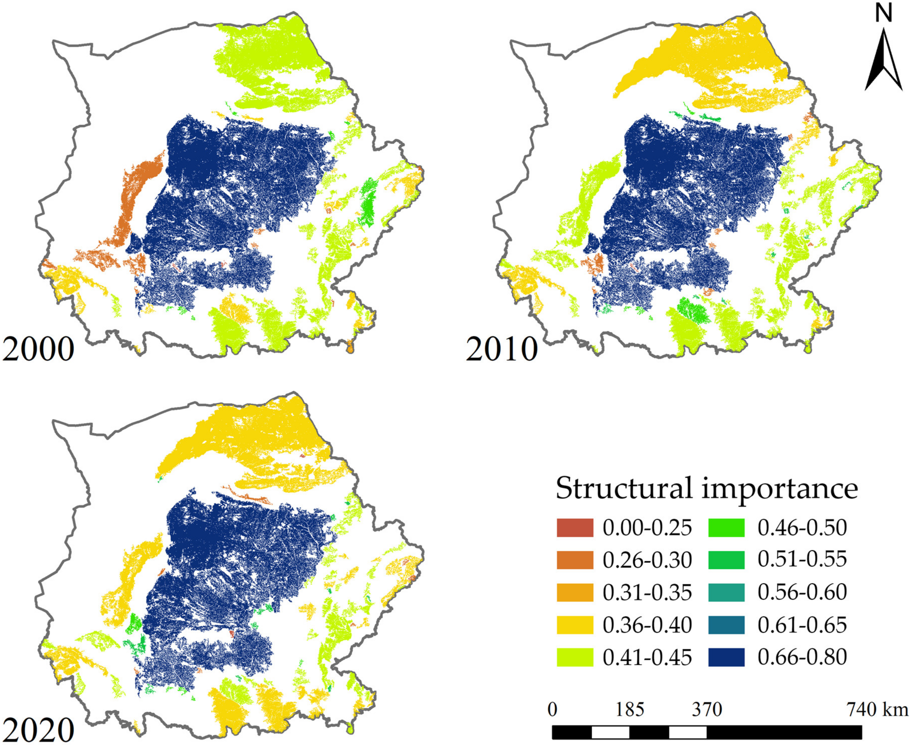
The topological importance of various ecological sources in the ESAMRYR is evaluated based on four indices, degree, betweenness centrality, clustering coefficient, and coreness, as shown in Figure 12. The average values of the topological importance of ecological source in the ecological space network in 2000, 2010, and 2020 are 0.4012, 0.4152, and 0.4100, respectively, indicating a basic stability in the topological importance of ecological sources in the network. In all three periods, the topological importance of central grass-grazing land block is the highest, above 0.7, while the topological importance of other blocks is below 0.52.
Approximately half of the sources with low topological importance values can also be found in the network, primarily in the grassy marsh sources in the southern part of Ningxia and the city of Baiyin, the fragmented sources in the north and south of the central patch, and some sources in the eastern part of the ESAMRYR in the year 2000. In 2010, the network also increased in grassy marsh sources in the northernmost part of the ESAMRYR and some sources in the southeast corner of the ESAMRYR. In 2020, there was a decrease in sources in areas such as Hohhot and the southern part of Ningxia, but the topological importance of forest sources in the southern part of the ESAMRYR decreased below the average value. With the exception of two or three small sources that are only connected to large surrounding sources, the topological importance of all sources in the three stages of the network is above 0.25, with the patch with the lowest topological importance mainly located in grassy marsh sources in northern Ningxia in the year 2000 and some fragmented sources around the central patch and in the eastern part of the ESAMRYR in 2010 and 2020. In general, sources with high topological importance in the year 2000 were located in an eastern position, moved southward in 2010, with a decrease in topological importance of the grassy marsh sources in the north, and slightly moved westward and northward in 2020, with a decrease in topological importance of the forest sources in the south. Low topological importance ecological sources gradually spread from the southwestern part of the ESAMRYR to peripheral sources surrounding the ESAMRYR.

3.5.3. Coordination between Topological Importance and Functional Importance

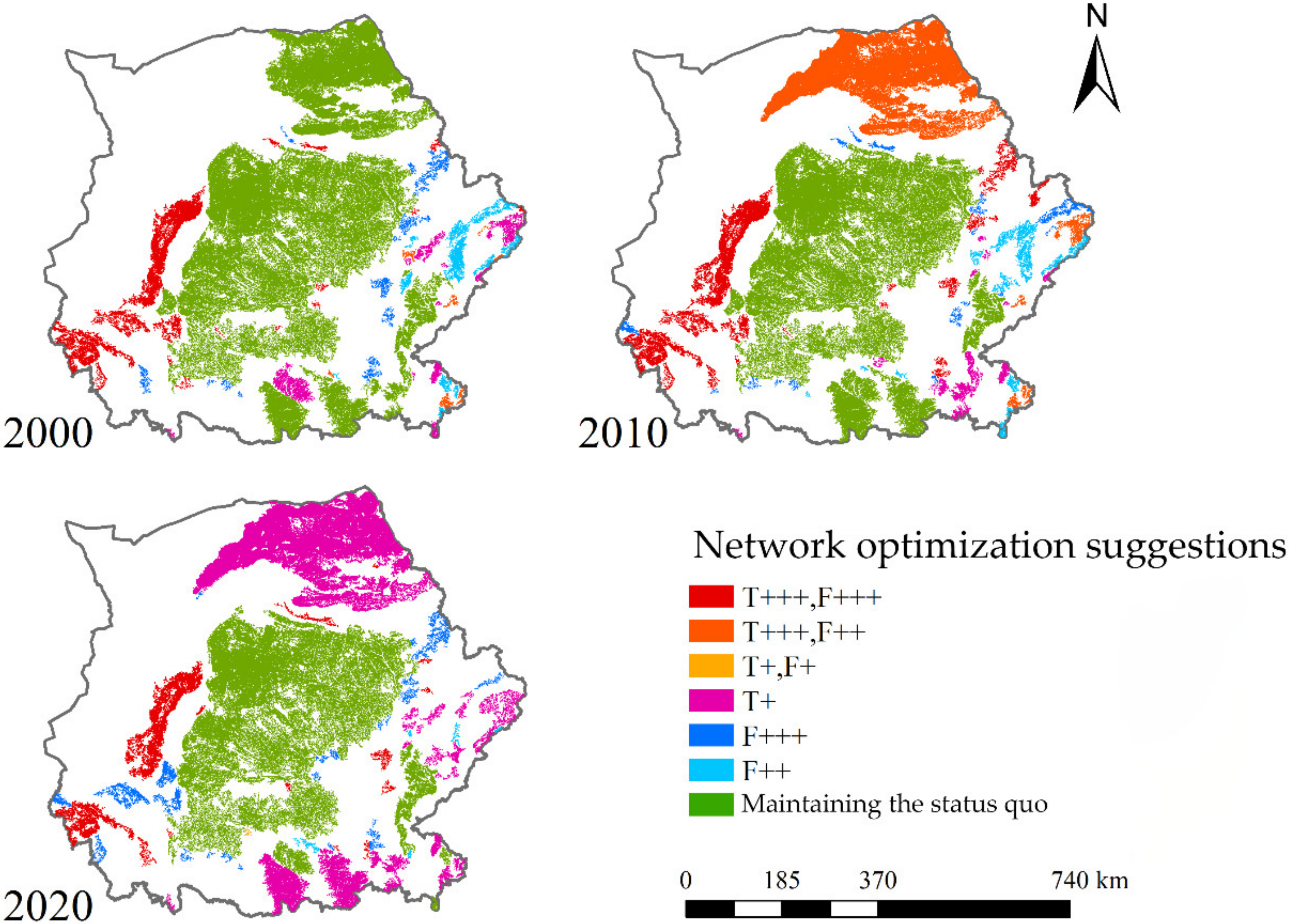
The results of the coherence analysis of the structure and function of the ecological source in the ESAMRYR are shown in Figure 13. The majority of the ecological sources have a higher topological importance than functional importance, and only a small portion of the forest sources on the eastern side of the ESAMRYR in the three time periods have slightly higher functional importance than topological importance. According to the TFCO model, the ecological sources in the ESAMRYR are divided into two categories of high and low coordination based on the degree of topological and functional coordination. The different situations in each category are then analyzed. For high coordination situations, optimization suggestions are given for blocks with low importance of structure or function. For low coordination situations, improvement of blocks with low importance of structure or function should be given priority and greater effort. For blocks with both important aspects in high coordination situations, maintaining the status quo is sufficient. In 2010, the structure and function of the grass–shrubland block in the north of the network were not well coordinated, and the structure was more important. However, in 2020, the structure and function of the block were relatively coordinated, and only slightly improving the structure was sufficient. Many blocks on the east and south margins of the ESAMRYR are also the same, just slightly improving the structure is sufficient.
The results of the aforementioned analysis indicate that the majority of the ecological sources in the study region are in good state, and only routine ecological protection work is needed. Approximately 12% of the ecological sources require prioritization of ecological construction and enhancement of ecological protection based on the baseline conditions through means such as “protecting blue and increasing green” to improve their functional significance. Approximately 8% of the ecological sources need to prioritize the strengthening of connectivity with surrounding ecological sources through measures such as the construction of protective forest belts and irrigation channels to enhance their topological significance. These ecological sources require focused attention, development, and protection.

3.6. Optimization of the Ecological Spatial Network in ESAMRYR

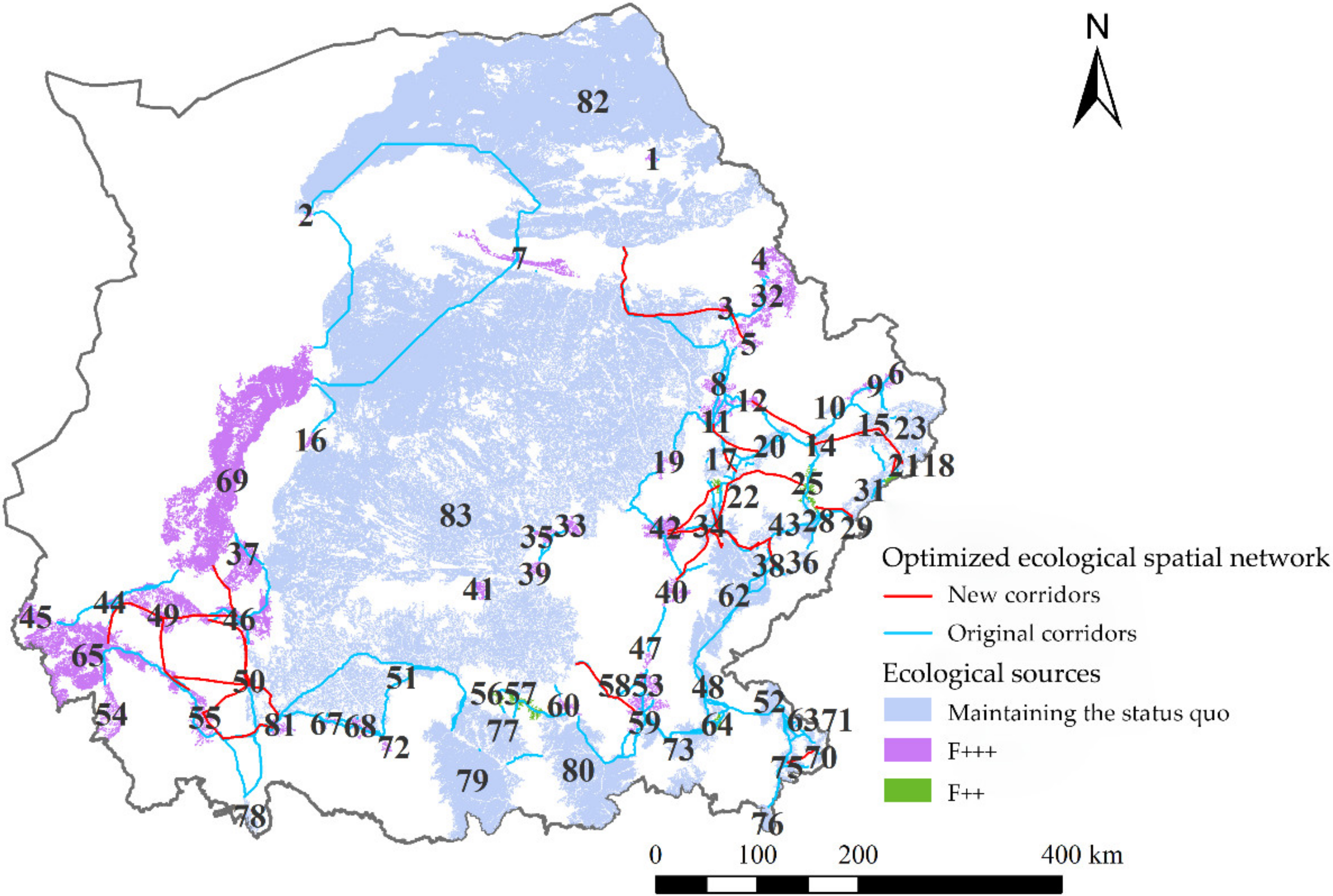
According to the analysis results of the TFCO model on the status and optimization recommendations of ecological sources, 42 ecological sources in the research area of the ecological space network in 2020 require improvement of topological significance, and 47 ecological sources need to enhance functional connectivity (Figure 14). For the sources that need to improve topological significance, the principle of lower priority is adopted to increase ecological corridors, with a total of 212 ecological corridors in the ecological space network in 2020 and a maximum number of new corridors of 42. According to the actual distribution and connection of each patch and the surrounding sources, 28 new ecological corridors were added in the research area, which are mainly distributed in the southwestern part of Ningxia in the research area and the inner area of Shanxi province in the east of the research area. These are indicated by red lines in Figure 15. For the sources that need to enhance functional connectivity, 40 F+++ sources, which need to be improved with priority and increased efforts according to the TFCO model’s assessment, are mainly located in the southwestern Ningxia and Baiyin city in the research area, as well as some small-area sources to the east and north of the central grass–shrubland patch. There are 7 F++ sources that are not so urgent, including sources 25, 26, 27, and 28 on the east side of the research area and sources 56, 57, and 64 on the south side, which are all forest sources.

3.7. Assessment of Optimization Effect

3.7.1. Carbon Sequestration

The TFCO model is evaluated in terms of both carbon sequestration and robustness to optimize the space-structure and carbon sequestration capacity of ecosystem in the ESAMRYR. The carbon sequestration function of the forest–grass vegetation is mainly provided by ecological sources. It is assumed that through ecological construction and protection, each grid cell in the F+++ type ecological source will increase by 20 gC/m2·yr (carbon fixed per unit area per year), and each grid cell in the F++ type ecological source will increase by 10 gC/m2·yr. The total carbon sequestration of the 47 blocks that need to enhance the function importance in the ESAMRYR is 215,310.73 tC/yr (total carbon fixed per year), which is 12.60% of the original carbon sequestration of these blocks (Table 4). The carbon sequestration increase of the grass–shrubland block accounts for 96.65%, while the carbon sequestration increase of the 4 F+++ type forest blocks with priority and enhanced function importance accounts for 1.74%, and the carbon sequestration increase of the 7 F++ type forest blocks accounts for 1.62%. This shows that the grass–shrubland blocks with large area are the key areas to be optimized in the ESAMRYR and are also the main body to achieve carbon sequestration enhancement.

3.7.2. Robustness

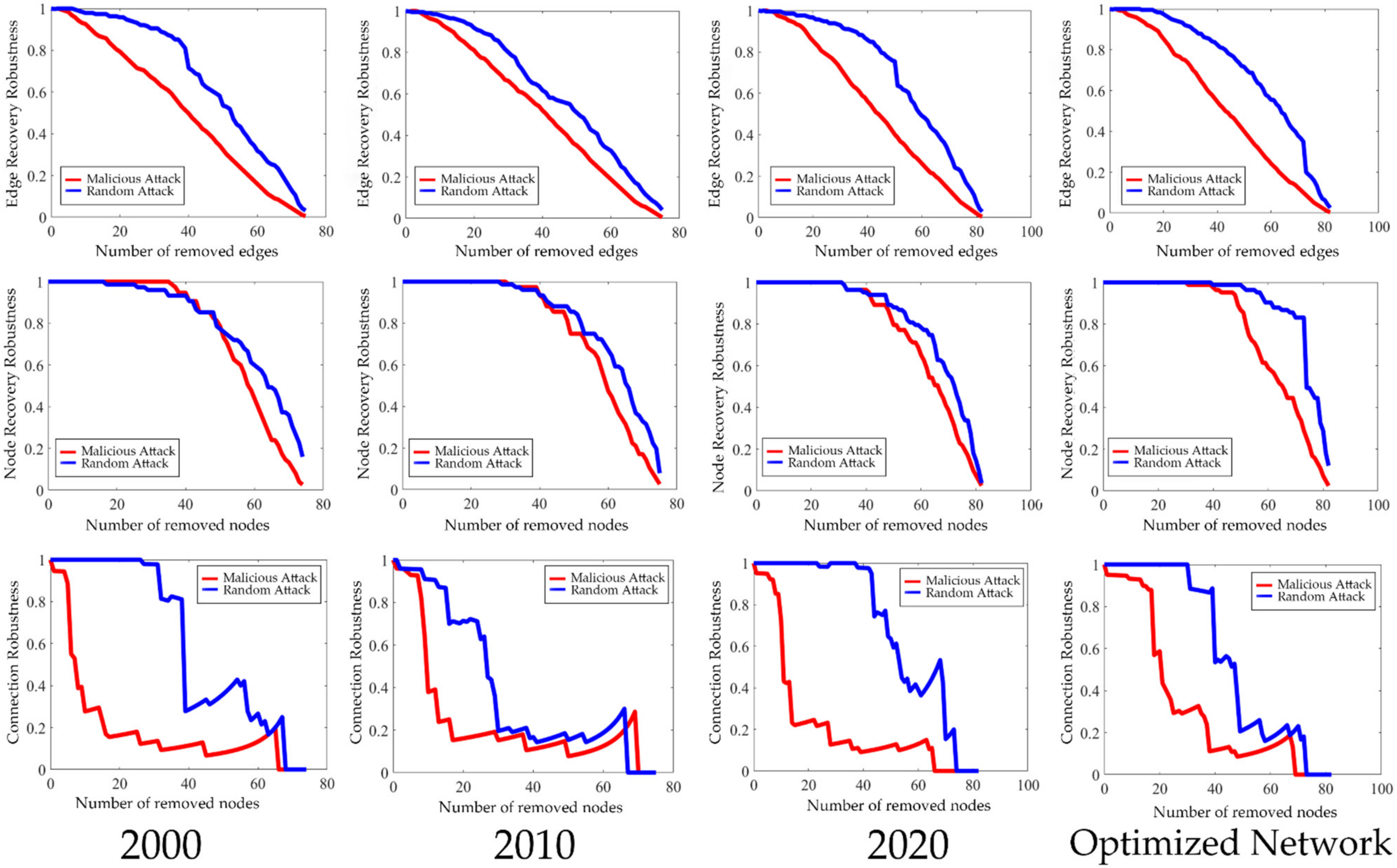
An experimental simulation of random and malicious attacks was performed on three distinct network periods and the optimized network to investigate the evolution of network connectivity robustness and recovery robustness with increasing attack intensity. The results, depicted in Figure 16, demonstrate that the rate of decline in both connectivity robustness and recovery robustness is noticeably faster in the case of malicious attacks compared to random attacks, as the latter exhibits randomness and the rate of decline in robustness is contingent on the sequence in which nodes are targeted.
Connectivity robustness presents a concave curve under malicious attacks, with the decrease in robustness becoming gradually slower as the number of attack nodes increases and starting to decrease from the second node. In 2000, the network started to experience a sudden drop in robustness from 0.89 to 0.28 when the 7th node was attacked, followed by a brief stability before continuing to decline to below 0.2 after the 17th node was attacked, resulting in nearly collapsing network connectivity. In 2010, the network started to experience a sudden drop in robustness from 0.89 to 0.24 when the 9th node was attacked, followed by a brief stability before continuing to decline to below 0.2 after the 18th node was attacked, resulting in nearly losing network connectivity. In 2020, the network started to experience a sudden drop in robustness from 0.89 to 0.22 when the 12th node was attacked, followed by several brief recoveries before declining again to below 0.2 after the 29th node was attacked. The optimized network started to experience a sudden drop in robustness from 0.89 to 0.29 when the 19th node was attacked, followed by a brief recovery before declining again to below 0.2 after the 38th node was attacked. In general, the network connectivity robustness in 2020 is better than in 2000 and 2010, and the optimization by adding 28 ecological corridor TFCO models resulted in a significant improvement in network connectivity robustness compared to 2020, with the initial drop point and the collapse point of connectivity being postponed and the rate of decline becoming slower.
The robustness of a network under random attacks is shown to exhibit a convex curve shape. The rate of decrease in robustness in the early stages of the attack is slower than in the later stages. However, under malicious attacks, the robustness of nodes tends to decrease linearly in the later stages of the attack, while the robustness of edges exhibits a slight S-shaped curve with a convex shape in the early stages and a concave shape in the later stages. Under malicious attacks, the 2000, 2010, 2020, and optimized networks, respectively, start to decrease their node robustness from the 37th, 32nd, 33rd, and 32nd node, with a slow-to-fast decrease rate. The number of nodes attacked when the robustness decreases to below 0.9 are 44, 42, 43, and 49, respectively; the number of nodes attacked when the robustness decreases to below 0.8 are 50, 49, 50, and 52, respectively; the number of nodes attacked when the robustness decreases to below 0.6 are 57, 58, 62, and 60, respectively; the number of nodes attacked when the robustness decreases to below 0.4 are 62, 63, 70, and 70, respectively; and the number of nodes attacked when the robustness decreases to below 0.2 are 68, 69, 76, and 76, respectively. Overall, the difference in node robustness among the networks is not significant. The node robustness recovery ability of the optimized network is slightly enhanced in the early stages of the attack, and its linear decrease rate in the later stages is faster than that of the unoptimized network. However, thanks to the stability in the early stages, the node robustness recovery in the later stages is roughly consistent with that in the early stages. As for edge robustness, it generally starts to decrease from the edges connected to the 5th node, and the decline trend and slope are generally consistent. Overall, the difference in edge robustness among the 2000, 2010, 2020, and optimized networks is not significant. Compared to the 2000 and 2010 networks, the 2020 and optimized networks have a slightly convex curve in the early stages of the attack, indicating slightly better edge robustness recovery in the early stages. The later stages are basically overlapping.

4. Discussion

This paper focuses on ESAMRYR as the study area. By using the analysis method of complex network theory and an optimized model of plant light energy utilization, combined with GIS spatial analysis technology, we constructed an ecological spatial network to investigate the topological structure, carbon sink function, cooperative optimization, and destruction simulation of forest and grass vegetation. We constructed the TFCO model, which combines the structural importance and functional importance of ecological sources, comprehensively evaluates their synergy, and proposes optimization strategies. Based on the optimization recommendations, 28 corridors were added to the ecological spatial network in 2020, and the functional importance of 47 patches was improved. After optimization, both the carbon sink capacity of the ecosystem and the stability of the ecological spatial network were significantly improved.
In similar studies, Zhang et al. used land use data and the morphological spatial pattern analysis method to extract ecological corridors and construct an ecological spatial network [43]. This extraction method is more in line with the actual landscape pattern, and compared to our study, it considers the influence of different shapes of ecological source areas on the transmission of information, matter, and ecological energy, which provides a direction for optimizing the extraction method of ecological corridors. In our study analyzing the landscape pattern and carbon sink capacity of the ecological sensitive area of the middle reaches of the Yellow River using the TFCO model, our proposed optimization strategy was to enhance the carbon sink capacity of existing ecological source areas and construct or propose ecological corridors. However, in the actual landscape, ecological engineering can be used to construct small ecological source areas at appropriate spatial locations through methods such as afforestation. Qiu et al. proposed to optimize the topological properties of the ecological spatial network by adding ecological stepping stones and demonstrated that ecological stepping stones significantly improve the carbon sink capacity and structural optimization effect of the ecological spatial network [44].

4.1. Optimization of the Assessment of Carbon Sequestration Capacity in Ecological Sources

The estimation of carbon sequestration capacity in ecological sources through the indirect conversion of vegetation net primary productivity (NPP) has a certain level of error due to differences in the fixed amount of CO2 required to produce the same biomass for various vegetation types. The disparities in CO2 utilization efficiency are a result of a multitude of factors such as vegetation type, growth environment, and their specific physiological and biochemical characteristics [45]. Additionally, the age, nutritional status, and water availability of vegetation also play a role in determining its CO2 utilization efficiency [46]. Subsequent studies can optimize the evaluation of carbon sequestration capacity in ecological sources by surveying the differences in CO2 utilization efficiency among different vegetation types and optimizing the distribution of ecological system vegetation types, thus making the estimation of vegetation carbon sequestration function more accurate.
Climate change is one of the most significant factors affecting the dynamic changes and distribution of vegetation NPP, and it will show apparent regional differences influenced by different hydrothermal conditions. For example, precipitation can alter the carbon sequestration capacity of an ecosystem by determining the vegetation type in different regions, while solar radiation can change the carbon sequestration capacity of an ecosystem by affecting the light energy received by vegetation. Therefore, the climate factor can be included in the subsequent ecological source-sink carbon assessment.

4.2. Optimization of Topological Assessment of Ecological Sources

We utilize network analysis to study the spatial structure of forest–grass vegetation, considering the weights of the ecological corridors between vegetation patches to be equal, and therefore use topological indicators of an undirected unweighted network to analyze vegetation structure. However, due to differences in natural conditions such as terrain, water temperature, and climate in different regions, the types and areas of patches connected by different corridors are also different, resulting in variations in the function of eco-corridors. Accordingly, using directed weighted network analysis to study vegetation structure is a future research direction. We should assign different weights to heterogeneous eco-corridors based on the accumulated resistance coefficients and the table linking resistance coefficients with weights and analyze their relevance based on the topological metrics of a weighted eco-space network combined with carbon sequestration capacity [21].
In the optimization of topological structure, the strategy of incrementing edges through complex network and graph theory models is relatively simple, and the determination of position is somewhat coarse. Subsequent research can incorporate the importance of nodes in the network, the composite ecological resistance value between nodes, and the supply situation of water sources into the consideration factors of the construction difficulty and feasibility of new ecological corridors, making the distribution of newly added corridors more in line with actual conditions. Additionally, based on complex network theory, the creation of new ecological nodes can also optimize the topological characteristics of the eco-space network. Future studies should focus on the optimization of the topological characteristics of the ecological system through the coordination of ecological sources and ecological corridors.
There are a multitude of topological metrics for assessing complex networks, in addition to the four topological metrics utilized in this study, such as proximity centrality, eigenvector centrality, average path length, and others [47]. Different metrics can reflect the varying properties of an ecological network. By incorporating a variety of topological metrics, a comprehensive evaluation of the topological characteristics of an ecological network can be achieved. When evaluating the optimized topological properties of an ecological network, merely relying on network robustness as an evaluation of stability through simulating network attacks is not exhaustive. Further research should calculate a range of topological metrics for the ecological network and conduct comparative analysis, combined with an evaluation of the ecological system’s functions for a comprehensive assessment.

5. Conclusions

The present study establishes a model of plant light utilization efficiency and calculates the carbon sequestration of the ecosystem in the ESAMRYR. The areas with the highest carbon sequestration are the regions where forests are distributed on the south and east sides, especially in the Sub-Wuling and Huanglong Mountain areas where deciduous broad-leaved forests are distributed. The next is the Ningxia plain, Hohhot City, etc. The southeast region has more rainfall and better growth of herbaceous vegetation, so the carbon sequestration of grasslands in the central part of the study area is higher in the southeast and lower in the northwest. Over the past 20 years, the carbon sequestration of most areas has increased, and the high-value carbon sequestration areas have spread to the northwest.
The eco-space network of the eco-sensitive region in the ESAMRYR was extracted, and various network topological metrics of three types of ecological nodes, namely, forests, shrublands, and high-coverage grasslands, were calculated. The ecological blocks in the east and south of the study area were small in area, far away, and with low ecological resistance between them, and the ecological corridors were long and dense. The grass–shrubland blocks in the central and northern regions were large in area and close in distance, with short ecological corridors. Over the past 20 years, as the number and area of blocks increased and the ecological resistance decreased, some regions gradually increased in the number of ecological corridors. The grass–shrubland block located in the center and with the largest area had the highest degree and the most obvious cluster relationship, and most of the ecological blocks in the ecological network were surrounded by and connected to it. In this study, we established a TFCO model that integrates the topological importance and functional importance of ecological sources to comprehensively evaluate the synergism between the two and provide optimization strategies. The blocks with high synergism in the study area are generally located in the central and southeast regions, while those with low synergism are mostly distributed in the southwest and northeast regions and are generally of high structural importance and low functional importance. By adding a total of 28 ecological corridors and improving the functional importance of 47 blocks, we optimized the ecological network in 2020. The results showed that the carbon sequestration of the optimized blocks can be increased by 215,310.73 tC/yr. The connectivity robustness of the optimized network was significantly improved; the initial rapid drop points and connectivity collapse points were postponed; the rate of decline slowed down; the node’s recovery ability was enhanced in the pre-attack stage; and the edge recovery robustness remained relatively unchanged.

Author Contributions

F.W.: Conceptualization, Methodology, Investigation, Formal analysis, Writing—original draft, Visualization. C.X.: Validation, Resources. Q.Y.: Writing—review and editing. H.G.: Supervision, Software, Methodology. S.Q.: Resources, Formal analysis. Q.Z.: Formal analysis, Investigation. All authors have read and agreed to the published version of the manuscript.

Funding

This research was funded by the National Natural Science Foundation of China Project (No. 420071237) and Youth Science Foundation of National Natural Science Foundation of China, grant number No. 42001211.

Data Availability Statement

Publicly available datasets were analyzed in this study. The data sources and access links are indicated in the text.

Acknowledgments

We are grateful to the graduate students and staff of the Beijing Key Laboratory of Precise Forestry, Beijing Forestry University.

Conflicts of Interest

The authors declare that they have no known competing financial interest or personal relationships that could have appeared to influence the work reported in this paper.

References

  1. Ledley, T.S.; Sundquist, E.T.; Schwartz, S.E.; Hall, D.K.; Fellows, J.D.; Killeen, T.L. Climate change and greenhouse gases. EOS 1999, 80, 453–458. [Google Scholar] [CrossRef]
  2. Kim, H.; Kim, S.; Dale, B.E.J.E.s. Technology, Biofuels, land use change, and greenhouse gas emissions: Some unexplored variables. Environ. Sci. Technol. 2009, 43, 961–967. [Google Scholar] [CrossRef] [PubMed]
  3. Mikhaylov, A.; Moiseev, N.; Aleshin, K.; Burkhardt, T.J.E.; Issues, S. Global climate change and greenhouse effect. Entrep. Sustain. Issues 2020, 7, 2897. [Google Scholar] [CrossRef] [PubMed]
  4. Hensher, D.A. Climate change, enhanced greenhouse gas emissions and passenger transport–What can we do to make a difference? Transp. Res. Part D Transp. Environ. 2008, 13, 95–111. [Google Scholar] [CrossRef]
  5. Zhang, H.; Li, S. Carbon emissions’ spatial-temporal heterogeneity and identification from rural energy consumption in China. J. Environ. Manag. 2022, 304, 114286. [Google Scholar] [CrossRef]
  6. Fang, M.; Si, G.; Yu, Q.; Huang, H.; Huang, Y.; Liu, W.; Guo, H.J.R.S. Study on the relationship between topological characteristics of vegetation ecospatial network and carbon sequestration capacity in the Yellow River Basin, China. Remote Sens. 2021, 13, 4926. [Google Scholar] [CrossRef]
  7. Xu, Q.; Yang, R.; Dong, Y.-X.; Liu, Y.-X.; Qiu, L.-R. The influence of rapid urbanization and land use changes on terrestrial carbon sources/sinks in Guangzhou, China. Ecol. Indic. 2016, 70, 304–316. [Google Scholar] [CrossRef]
  8. Xu, G.; Schwarz, P.; Yang, H. Adjusting energy consumption structure to achieve China’s CO2 emissions peak. Renew. Sustain. Energy Rev. 2020, 122, 109737. [Google Scholar] [CrossRef]
  9. Zhang, C.-y.; Zhao, L.; Zhang, H.; Chen, M.-n.; Fang, R.-y.; Yao, Y.; Zhang, Q.-p.; Wang, Q. Spatial-temporal characteristics of carbon emissions from land use change in Yellow River Delta region, China. Ecol. Indic. 2022, 136, 108623. [Google Scholar] [CrossRef]
  10. Piao, S.; Fang, J.; Ciais, P.; Peylin, P.; Huang, Y.; Sitch, S.; Wang, T. The carbon balance of terrestrial ecosystems in China. Nature 2009, 458, 1009–1013. [Google Scholar] [CrossRef]
  11. Lloyd, J. The CO2 dependence of photosynthesis, plant growth responses to elevated CO2 concentrations and their interaction with soil nutrient status, II. Temperate and boreal forest productivity and the combined effects of increasing CO2 concentrations and increased nitrogen deposition at a global scale. Funct. Ecol. 1999, 13, 439–459. [Google Scholar]
  12. Li, K.; Wang, S.; Cao, M. Vegetation and soil carbon storage in China. Sci. China Earth Sci. 2004, 47, 49–57. [Google Scholar] [CrossRef]
  13. Song, C.; Woodcock, C.E. A regional forest ecosystem carbon budget model: Impacts of forest age structure and landuse history. Ecol. Model. 2003, 164, 33–47. [Google Scholar] [CrossRef]
  14. Yu, Q.; Yue, D.; Wang, Y.; Kai, S.; Fang, M.; Ma, H.; Zhang, Q.; Huang, Y. Optimization of ecological node layout and stability analysis of ecological network in desert oasis: A typical case study of ecological fragile zone located at Deng Kou County (Inner Mongolia). Ecol. Indic. 2018, 84, 304–318. [Google Scholar] [CrossRef]
  15. Parker, K.; Head, L.; Chisholm, L.A.; Feneley, N.J.L.; Planning, U. A conceptual model of ecological connectivity in the Shellharbour local government area, New South Wales, Australia. Landsc. Urban Plan. 2008, 86, 47–59. [Google Scholar] [CrossRef]
  16. Hagen, M.; Kissling, W.D.; Rasmussen, C.; De Aguiar, M.A.; Brown, L.E.; Carstensen, D.W.; Alves-Dos-Santos, I.; Dupont, Y.L.; Edwards, F.K.; Genini, J. Biodiversity, species interactions and ecological networks in a fragmented world. In Advances in Ecological Research; Elsevier: Amsterdam, The Netherlands, 2012; Volume 46, pp. 89–210. [Google Scholar]
  17. Xu, W.; Wang, J.; Zhang, M.; Li, S. Construction of landscape ecological network based on landscape ecological risk assessment in a large-scale opencast coal mine area. J. Clean. Prod. 2021, 286, 125523. [Google Scholar] [CrossRef]
  18. Delmas, E.; Besson, M.; Brice, M.H.; Burkle, L.A.; Riva, G.V.D.; Fortin, M.J.; Gravel, D.; Guimarães, P.R., Jr.; Hembry, D.H.; Newman, E.A.J.B.R. Analysing ecological networks of species interactions. Biol. Rev. Camb. Philos. Soc. 2019, 94, 16–36. [Google Scholar] [CrossRef]
  19. Zhao, S.-M.; Ma, Y.-F.; Wang, J.-L.; You, X.-Y. Landscape pattern analysis and ecological network planning of Tianjin City. Urban For. Urban Green. 2019, 46, 126479. [Google Scholar] [CrossRef]
  20. Peng, J.; Yang, Y.; Liu, Y.; Du, Y.; Meersmans, J.; Qiu, S.J. Linking ecosystem services and circuit theory to identify ecological security patterns. Sci. Total. Environ. 2018, 644, 781–790. [Google Scholar] [CrossRef]
  21. Wang, F.; Yu, Q.; Qiu, S.; Xu, C.; Ma, J.; Liu, H. Study on the relationship between topological characteristics of ecological spatial network and soil conservation function in southeastern Tibet, China. Ecol. Indic. 2023, 146, 109791. [Google Scholar] [CrossRef]
  22. Zhao, G.; Tian, P.; Mu, X.; Jiao, J.; Wang, F.; Gao, P. Quantifying the impact of climate variability and human activities on streamflow in the middle reaches of the Yellow River basin, China. J. Hydrol. 2014, 519, 387–398. [Google Scholar] [CrossRef]
  23. Zhang, Q.; Xu, C.-Y.; Chen, Y.D.; Ren, L. Comparison of evapotranspiration variations between the Yellow River and Pearl River basin, China. Stoch. Environ. Res. Risk Assess. 2011, 25, 139–150. [Google Scholar] [CrossRef]
  24. Gao, P.; Mu, X.-M.; Wang, F.; Li, R.J.H.; Sciences, E.S. Changes in streamflow and sediment discharge and the response to human activities in the middle reaches of the Yellow River. Hydrol. Earth Syst. Sci. 2011, 15, 1–10. [Google Scholar] [CrossRef]
  25. Pan, B.; Hu, Z.; Wang, J.; Vandenberghe, J.; Hu, X. A magnetostratigraphic record of landscape development in the eastern Ordos Plateau, China: Transition from Late Miocene and Early Pliocene stacked sedimentation to Late Pliocene and Quaternary uplift and incision by the Yellow River. Geomorphology 2011, 125, 225–238. [Google Scholar] [CrossRef]
  26. Xu, D.; Kang, X.; Zhuang, D.; Pan, J. Multi-scale quantitative assessment of the relative roles of climate change and human activities in desertification–a case study of the Ordos Plateau, China. J. Arid. Environ. 2010, 74, 498–507. [Google Scholar] [CrossRef]
  27. Tomar, V.; Mandal, V.P.; Srivastava, P.; Patairiya, S.; Singh, K.; Ravisankar, N.; Subash, N.; Kumar, P. Rice equivalent crop yield assessment using MODIS sensors’ based MOD13A1-NDVI data. IEEE Sens. J. 2014, 14, 3599–3605. [Google Scholar] [CrossRef]
  28. Su, K.; Yu, Q.; Yue, D.; Zhang, Q.; Yang, L.; Liu, Z.; Niu, T.; Sun, X. Simulation of a forest-grass ecological network in a typical desert oasis based on multiple scenes. Ecol. Model. 2019, 413, 108834. [Google Scholar] [CrossRef]
  29. An, Y.; Liu, S.; Sun, Y.; Shi, F.; Beazley, R. Construction and optimization of an ecological network based on morphological spatial pattern analysis and circuit theory. Landsc. Ecol. 2020, 36, 2059–2076. [Google Scholar] [CrossRef]
  30. Li, Y.-Y.; Zhang, Y.-Z.; Jiang, Z.-Y.; Guo, C.-X.; Zhao, M.-Y.; Yang, Z.-G.; Guo, M.-Y.; Wu, B.-Y.; Chen, Q.-L. Integrating morphological spatial pattern analysis and the minimal cumulative resistance model to optimize urban ecological networks: A case study in Shenzhen City, China. Ecol. Process. 2021, 10, 1–15. [Google Scholar] [CrossRef]
  31. Dong, J.; Dai, W.; Shao, G.; Xu, J. Ecological network construction based on minimum cumulative resistance for the city of Nanjing, China. ISPRS Int. J. Geo-Inform. 2015, 4, 2045–2060. [Google Scholar] [CrossRef]
  32. Balbi, M.; Petit, E.J.; Croci, S.; Nabucet, J.; Georges, R.; Madec, L.; Ernoult, A. Ecological relevance of least cost path analysis: An easy implementation method for landscape urban planning. J. Environ. Manag. 2019, 244, 61–68. [Google Scholar] [CrossRef]
  33. Ding, R.J.C. The complex network theory-based urban land-use and transport interaction studies. Complexity 2019, 2019, 4180890. [Google Scholar] [CrossRef]
  34. Liu, H.; Niu, T.; Yu, Q.; Yang, L.; Ma, J.; Qiu, S.; Wang, R.; Liu, W.; Li, J. Spatial and temporal variations in the relationship between the topological structure of eco-spatial network and biodiversity maintenance function in China. Ecol. Indic. 2022, 139, 108919. [Google Scholar] [CrossRef]
  35. Heer, H.; Streib, L.; Schäfer, R.B.; Ruzika, S. Maximising the clustering coefficient of networks and the effects on habitat network robustness. PLoS ONE 2020, 15, e0240940. [Google Scholar] [CrossRef]
  36. Pereira, M.; Segurado, P.; Neves, N. Using spatial network structure in landscape management and planning: A case study with pond turtles. Landsc. Urban Plan. 2011, 100, 67–76. [Google Scholar] [CrossRef]
  37. Galiana, N.; Lurgi, M.; Bastazini, V.A.; Bosch, J.; Cagnolo, L.; Cazelles, K.; Claramunt-López, B.; Emer, C.; Fortin, M.-J.; Grass, I.J.N.e.; et al. Ecological network complexity scales with area. Nat. Ecol. Evol. 2022, 6, 307–314. [Google Scholar] [CrossRef] [PubMed]
  38. Cramer, W.; Kicklighter, D.W.; Bondeau, A.; Iii, B.M.; Churkina, G.; Nemry, B.; Ruimy, A.; Schloss, A.L. The. Participants of The Potsdam NPP. Model Intercomparison. Comparing global models of terrestrial net primary productivity (NPP): Overview and key results. Glob. Chang. Biol. 1999, 5, 1–15. [Google Scholar] [CrossRef]
  39. Woodward, F.; Smith, T.M. Predictions and measurements of the maximum photosynthetic rate, A max, at the global scale. Ecophysiol. Photosynth. 1995, 100, 491–509. [Google Scholar]
  40. Makino, A.; Mae, T. Photosynthesis and plant growth at elevated levels of CO2. Plant Cell Physiol. 1999, 40, 999–1006. [Google Scholar] [CrossRef]
  41. Zhou, L.; Liu, Z.; Wang, Z.; Yu, S.; Long, T.; Zhou, X.; Bao, Y. Astragalus polysaccharides exerts immunomodulatory effects via TLR4-mediated MyD88-dependent signaling pathway in vitro and in vivo. Sci. Rep. 2017, 7, 1–13. [Google Scholar] [CrossRef]
  42. Yang, L.; Niu, T.; Yu, Q.; Zhang, X.; Wu, H. Relationship between Topological Structure and Ecosystem Services of Forest Grass Ecospatial Network in China. Remote Sens. 2022, 14, 4700. [Google Scholar] [CrossRef]
  43. Zhang, R.; Zhang, L.; Zhong, Q.; Zhang, Q.; Ji, Y.; Song, P.; Wang, Q. An optimized evaluation method of an urban ecological network: The case of the Minhang District of Shanghai. Urban For. Urban Green. 2021, 62, 127158. [Google Scholar] [CrossRef]
  44. Qiu, S.; Yu, Q.; Niu, T.; Fang, M.; Guo, H.; Liu, H.; Li, S.; Zhang, J. Restoration and renewal of ecological spatial network in mining cities for the purpose of enhancing carbon Sinks: The case of Xuzhou, China. Ecol. Indic. 2022, 143, 109313. [Google Scholar] [CrossRef]
  45. Drake, B.G.; Gonzàlez-Meler, M.A.; Long, S.P. More efficient plants: A consequence of rising atmospheric CO2? Annu. Rev. Plant Physiol. Plant Mol. Biol. 1997, 48, 609–639. [Google Scholar] [CrossRef]
  46. Raven, J.A.; Handley, L.L.; Wollenweber, B. Plant nutrition and water use efficiency. Water Use Effic. Plant Biol. 2004, 171–197. [Google Scholar] [CrossRef]
  47. Jiang, B.; Claramunt, C. Topological analysis of urban street networks. Environ. Plan. B Plan. Des. 2004, 31, 15. [Google Scholar] [CrossRef]
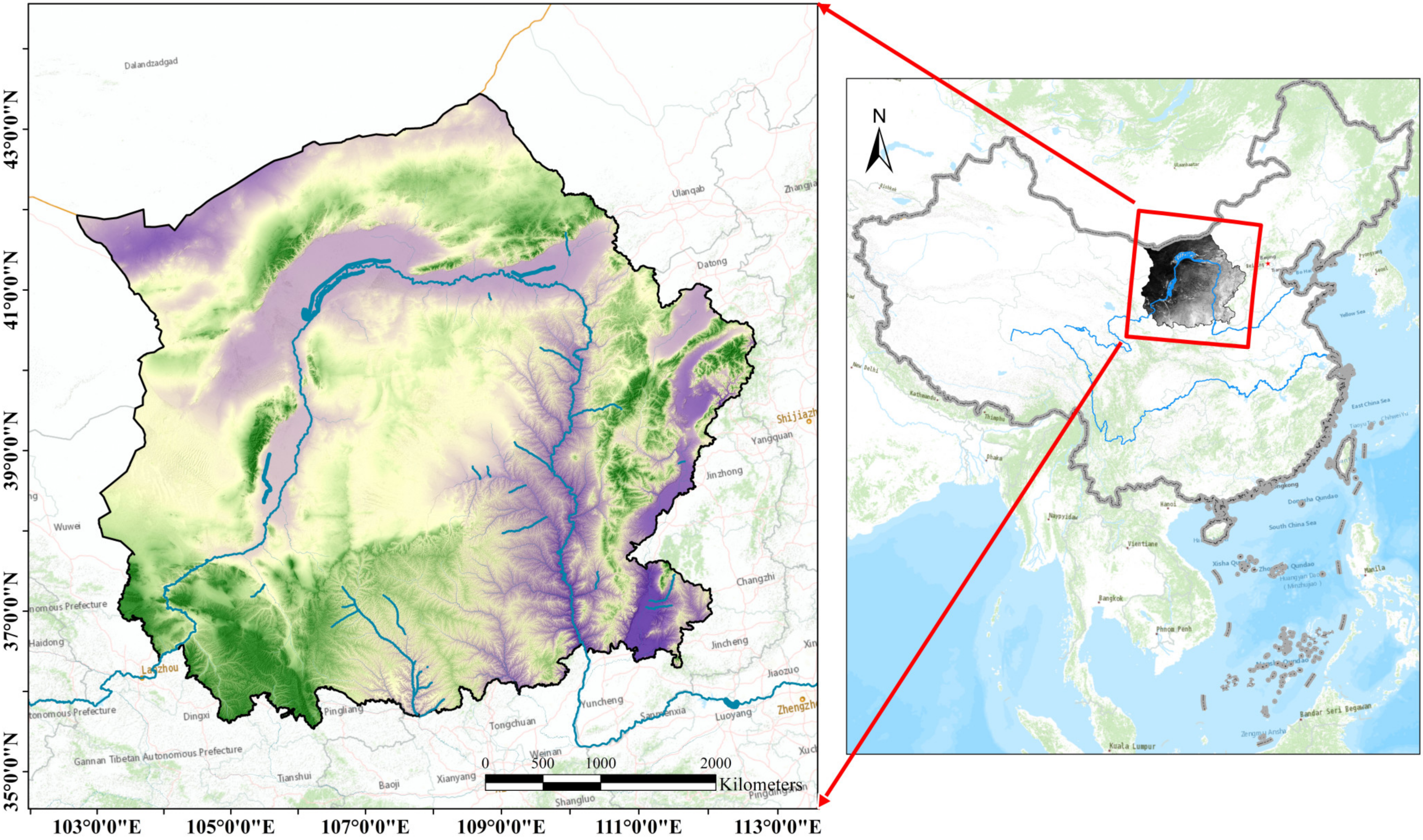
Figure 1. Location of ESAMRYR.
Remotesensing 15 02308 g001
Figure 2. Framework for Running TFCO Model.
Remotesensing 15 02308 g002
Figure 3. Statistical analysis of changes in the area of ecological sources.
Remotesensing 15 02308 g003
Figure 4. Statistical analysis of changes in the number of ecological sources.
Remotesensing 15 02308 g004
Figure 5. Cumulative resistance surface.
Remotesensing 15 02308 g005
Figure 6. Ecological spatial network.
Remotesensing 15 02308 g006
Figure 7. Cluster relationship of nodes in the network.
Remotesensing 15 02308 g007
Figure 8. Topological characteristics of nodes in the network.
Remotesensing 15 02308 g008
Figure 9. Spatial distribution of NPP.
Remotesensing 15 02308 g009
Figure 10. Vegetation carbon sequestration in the ESAMRYR.
Remotesensing 15 02308 g010
Figure 11. Functional importance of the ecological sources.
Remotesensing 15 02308 g011
Figure 12. Topological importance of the ecological sources.
Remotesensing 15 02308 g012
Figure 13. Topological and functional synergies of the ecological sources.
Remotesensing 15 02308 g013
Figure 14. TFCO model optimization suggestions.
Remotesensing 15 02308 g014
Figure 15. The optimized ecological space network.
Remotesensing 15 02308 g015
Figure 16. Robustness of ecological spatial networks.
Remotesensing 15 02308 g016
Table 1. Ecological Topological Indices.
Topological IndexTopological DefinitionEcological Significance of Topological IndicesReferences
Betweenness centralityThe proportion of all shortest paths in the network that pass through node v.It evaluates the ability of ecological sources to maintain the information and material exchange in the ecological space network, and reflects its role and influence in the network.[34]
Clustering coefficientThe ratio of the number of actual edges between k neighboring nodes of node v to the number of possible edges.It reflects the connectivity of the ecological sources around the source.[35]
CorenessThe number of nodes remaining in the subgraph after repeatedly removing nodes and their connections smaller than k.It measures the connectivity of the ecological system.[36]
DegreeThe number of edges connecting a node in a network.It reflects the efficiency of information and material communication between ecological sources and ecosystems.[37]
Table 2. Maximum light energy utilization of typical vegetation types.
Vegetation TypeMaximum Light Use Efficiency (gC/MJ)Vegetation TypeMaximum Light Use Efficiency (gC/MJ)
Deciduous coniferous forest0.485Shrub0.429
Evergreen coniferous forest0.389Grassland0.542
Deciduous broad-leaved forest0.692Cultivated Vegetation0.542
Mixed forest0.475Other0.542
Table 3. Carbon sequestration by land cover type in the ESAMRYR.
200020102020
Carbon Sequestration (tC/yr)Proportion (%)Carbon Sequestration (tC/yr)Proportion (%)Carbon Sequestration (tC/yr)Proportion (%)
Cultivated land13,163,611.8537.5614,946,366.0436.7716,649,330.1637.69
Forest6,503,518.4218.568,088,711.8219.909,399,560.9021.28
Grassland15,133,555.8943.1817,121,131.8442.1217,629,028.0839.91
Shrubland243,602.500.70491,432.101.21499,548.691.13
Total35,044,288.6610040,647,641.8010044,177,467.82100
Table 4. Optimization effect of the functional importance of ecological patches.
StateTypeAmountArea (km2)Original Carbon Sequestration (tC/yr)Carbon Sequestration Increment (tC/yr)Proportion (%)
T+++, F+++Forest153.2811,502.14484.510.23
T+++, F+++Grass and shrubland1315,425.12781,788.85136,744.0763.51
F+++Forest3364.8463,272.303255.971.51
F+++Grass and shrubland238059.96678,197.9871,344.6333.14
F++Forest7786.44174,106.363481.551.62
Total 4724,689.641,708,867.63215,310.73100.00
Disclaimer/Publisher’s Note: The statements, opinions and data contained in all publications are solely those of the individual author(s) and contributor(s) and not of MDPI and/or the editor(s). MDPI and/or the editor(s) disclaim responsibility for any injury to people or property resulting from any ideas, methods, instructions or products referred to in the content.