Deep Retrieval Architecture of Temperature and Humidity Profiles from Ground-Based Infrared Hyperspectral Spectrometer


Abstract
:1. Introduction
- Physical inversion methods apply the physical characteristics of atmospheric radiation transfer and the iterative optimization strategy. One representative method, named AERIprof [9,10,11], is based upon an onion-peeling technique. AERIprof performs with greater efficiency because it only needs to compute the diagonal of the Jacobian matrix. However, the main drawback of the algorithm is that it heavily relies on the accuracy of the statistical first guess. To surmount the problem, another paradigm based on the optimal estimation [12], i.e., AERIoe [13,14], applies a Gauss–Newton optimal estimation scheme to retrieve thermodynamic profiles.
- Statistical inversion methods [15] construct the regression equation defined by the atmospheric parameters and the radiometer measurements from the spectral channels. The eigenvector (EV) regression method [16], as one popular statistical inversion method, establishes the linear regression relationship between the atmospheric observations and the corresponding radiometer data via the least squares to obtain the inversion results. The BP neural network algorithm [17] can realize the nonlinear projection from the input observations to the output retrieval profiles. Compared with the EV regression method, it is more inclined to portray the physical essence of atmospheric temperature and humidity profile retrievals.
- (1)
- We propose a novel deep learning framework named DReA for the retrieval of atmospheric profiles from ground-based infrared hyperspectral spectrometer observations.
- (2)
- The proposed DReA is constructed using 1D CNN, which is highlighted and can fully exploit the high nonlinear relation between the observations and the atmospheric profiles.
- (3)
- Comprehensive experiments are conducted to demonstrate that the proposed method outperforms the existing statistic methods. Furthermore, we present some case studies which verify that the proposed method can still efficiently retrieve the atmospheric profiles even when there are cold and warm frontal passages.
2. Data Sources
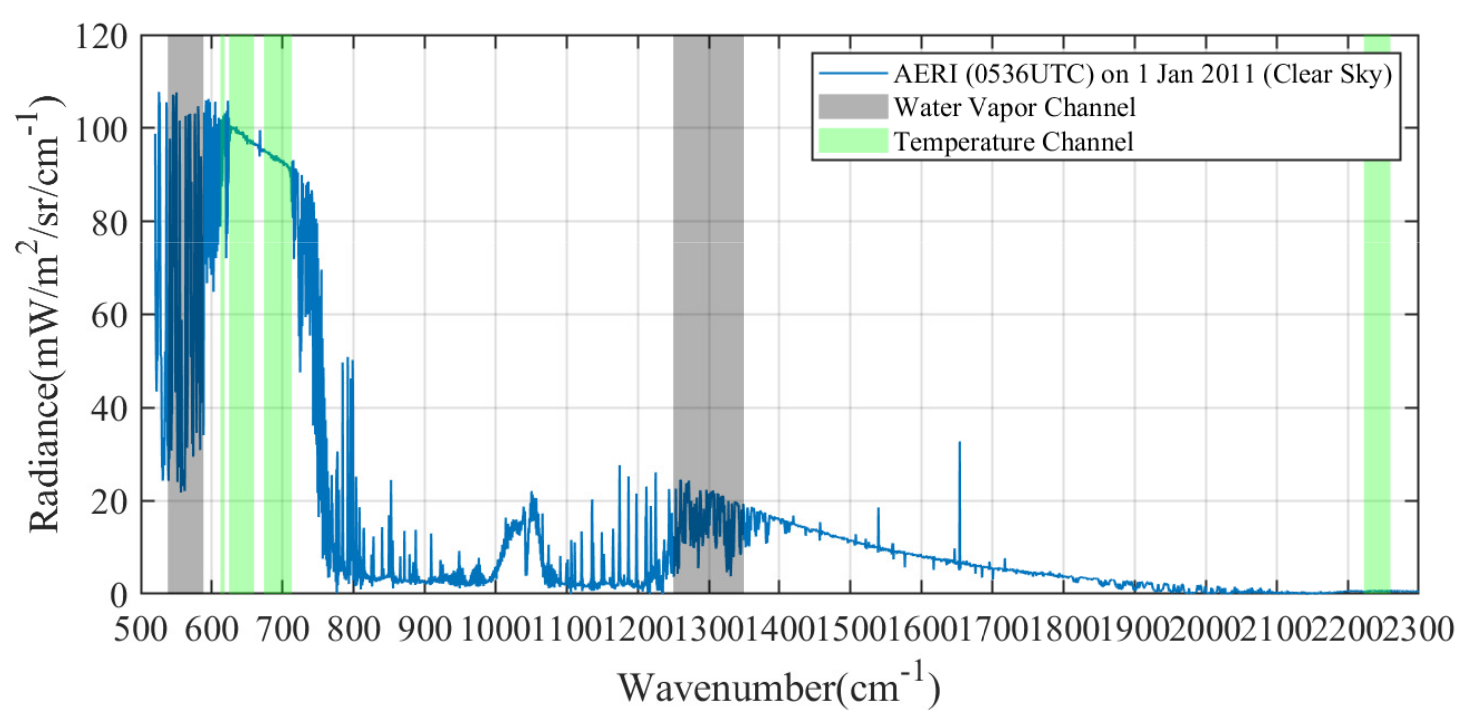
2.1. AERI Data
2.2. Radiosonde Data
2.3. Retrieval Methodology
2.4. The Retrieval Problem Formulation
2.4.1. One-Dimensional Convolutional Layer
2.4.2. One-Dimensional Max Pooling Layer
2.4.3. FC Layer
2.4.4. ReLU
2.4.5. BN Layer
2.5. Deep Retrieval Architecture (DReA)
2.5.1. The Forward Propagation of DReA
2.5.2. The Training of DReA
3. Experiments
3.1. Network Setting
3.2. Implementation Details
3.2.1. Data Preprocessing
- (1)
- Quality control [43]: AERI radiation spectra may contain outliers in the measuring process, so some spectral features with obvious outliers, e.g., negative radiation and smoothed spectra, were removed for obtaining a good quality.
- (2)
- Cloud mask: the presence of clouds can significantly impact the observed AERI radiation, so the laser cloud altimeter and the AERI radiation data themselves were used for cloud detection to select clear sky samples.
- (3)
- Temporal matching: the measurement data obtained from each observation instrument were matched in time, and the time of the sounding was used as the guide to select AERI data with the closest time for comparison.
3.2.2. Network Training Details
3.3. Comparison Methods
3.4. Evaluation Criteria
3.5. Results and Analysis
3.5.1. Validation of DReA
3.5.2. Comparison Experiments
3.5.3. Bias Variation with Height
3.5.4. Case Studies
Single Day Analysis
Cold Frontal Passages
Warm-Air Advection
4. Conclusions
Author Contributions
Funding
Data Availability Statement
Conflicts of Interest
References
- Wulfmeyer, V.; Hardesty, R.M.; Turner, D.D.; Behrendt, A.; Cadeddu, M.P.; Di Girolamo, P.; Schlüssel, P.; Van Baelen, J.; Zus, F. A review of the remote sensing of lower tropospheric thermodynamic profiles and its indispensable role for the understanding and the simulation of water and energy cycles. Rev. Geophys. 2015, 53, 819–895. [Google Scholar] [CrossRef]
- Wu, H.; Ni, L.; Wang, N.; Qian, Y.; Tang, B.H.; Li, Z.L. Estimation of atmospheric profiles from hyperspectral infrared IASI sensor. IEEE J. Sel. Top. Appl. Earth Obs. Remote Sens. 2013, 6, 1485–1494. [Google Scholar] [CrossRef]
- Holtslag, A.A.M.; Svensson, G.; Baas, P.; Basu, S.; Beare, B.; Beljaars, A.C.M.; Bosveld, F.C.; Cuxart, J.; Lindvall, J.; Steeneveld, G.J.; et al. Stable Atmospheric Boundary Layers and Diurnal Cycles: Challenges for Weather and Climate Models. Bull. Am. Meteorol. Soc. 2013, 94, 1691–1706. [Google Scholar] [CrossRef]
- Turner, D.D.; Löhnert, U. Ground-based temperature and humidity profiling: Combining active and passive remote sensors. Atmos. Meas. Tech. 2021, 14, 3033–3048. [Google Scholar] [CrossRef]
- Ingleby, B. An Assessment of Different Radiosonde Types 2015/2016; European Centre for Medium Range Weather Forecasts Reading: London, UK, 2017. [Google Scholar]
- Durre, I.; Vose, R.S.; Wuertz, D.B. Overview of the integrated global radiosonde archive. J. Clim. 2006, 19, 53–68. [Google Scholar] [CrossRef]
- Gonzalez, L.; Kos, L.; Lavas, S.; Douglas, M. A new possible plan for a more cost-effective adaptive radiosonde observing strategy for the United States. J. Atmos. Ocean. Technol. 2012, 1–25. [Google Scholar]
- Xu, G.; Xi, B.; Zhang, W.; Cui, C.; Dong, X.; Liu, Y.; Yan, G. Comparison of atmospheric profiles between microwave radiometer retrievals and radiosonde soundings. J. Geophys. Res. Atmos. 2015, 120, 10–313. [Google Scholar] [CrossRef]
- Smith, W.L.; Feltz, W.F.; Knuteson, R.O.; Revercomb, H.E.; Woolf, H.M.; Howell, H.B. The retrieval of planetary boundary layer structure using ground-based infrared spectral radiance measurements. J. Atmos. Ocean. Technol. 1999, 16, 323–333. [Google Scholar] [CrossRef]
- Feltz, W.F.; Smith, W.L.; Knuteson, R.O.; Revercomb, H.E.; Woolf, H.M.; Howell, H.B. Meteorological applications of temperature and water vapor retrievals from the ground-based Atmospheric Emitted Radiance Interferometer (AERI). J. Appl. Meteorol. 1998, 37, 857–875. [Google Scholar] [CrossRef]
- Feltz, W.; Howell, H.; Knuteson, R.; Comstock, J.; Mahon, R.; Turner, D.; Smith, W.; Woolf, H.; Sivaraman, C.; Halter, T. Retrieving Temperature and Moisture Profiles from AERI Radiance Observations: AERIPROF Value-Added Product Technical Description Revision 1; Technical report, DOE Office of Science Atmospheric Radiation Measurement (ARM) Program; U.S. Department of Energy: Washington, DC, USA, 2007. [Google Scholar]
- Rodgers, C.D. Inverse Methods for Atmospheric Sounding: Theory and Practice; World Scientific: Singapore, 2000; Volume 2. [Google Scholar]
- Turner, D.; Löhnert, U. Information content and uncertainties in thermodynamic profiles and liquid cloud properties retrieved from the ground-based Atmospheric Emitted Radiance Interferometer (AERI). J. Appl. Meteorol. Climatol. 2014, 53, 752–771. [Google Scholar] [CrossRef]
- Turner, D.D.; Blumberg, W.G. Improvements to the AERIoe thermodynamic profile retrieval algorithm. IEEE J. Sel. Top. Appl. Earth Obs. Remote Sens. 2018, 12, 1339–1354. [Google Scholar] [CrossRef]
- Ho, S.P.B. Atmospheric Profiles from Simultaneous Observations of Upwelling and Downwelling Spectral Radiance; The University of Wisconsin-Madison: Dallas, TX, USA, 1998. [Google Scholar]
- Smith, W.; Woolf, H. The use of eigenvectors of statistical covariance matrices for interpreting satellite sounding radiometer observations. J. Atmos. Sci. 1976, 33, 1127–1140. [Google Scholar] [CrossRef]
- Polyakov, A.; Timofeev, Y.M.; Virolainen, Y.A. Using artificial neural networks in the temperature and humidity sounding of the atmosphere. Izv. Atmos. Ocean. Phys. 2014, 50, 330–336. [Google Scholar] [CrossRef]
- Yuan, Q.; Shen, H.; Li, T.; Li, Z.; Li, S.; Jiang, Y.; Xu, H.; Tan, W.; Yang, Q.; Wang, J.; et al. Deep learning in environmental remote sensing: Achievements and challenges. Remote Sens. Environ. 2020, 241, 111716. [Google Scholar] [CrossRef]
- Salman, A.G.; Kanigoro, B.; Heryadi, Y. Weather forecasting using deep learning techniques. In Proceedings of the 2015 International Conference on Advanced Computer Science and Information Systems (ICACSIS), Depok, Indonesia, 10–11 October 2015; pp. 281–285. [Google Scholar]
- Rodrigues, E.R.; Oliveira, I.; Cunha, R.; Netto, M. DeepDownscale: A deep learning strategy for high-resolution weather forecast. In Proceedings of the 2018 IEEE 14th International Conference on e-Science (e-Science), Amsterdam, The Netherlands, 29 October–1 November 2018; pp. 415–422. [Google Scholar]
- Grönquist, P.; Yao, C.; Ben-Nun, T.; Dryden, N.; Dueben, P.; Li, S.; Hoefler, T. Deep learning for post-processing ensemble weather forecasts. Philos. Trans. R. Soc. A 2021, 379, 20200092. [Google Scholar] [CrossRef]
- Chu, Y.; Liu, Y.; Li, X.; Liu, Z.; Lu, H.; Lu, Y.; Mao, Z.; Chen, X.; Li, N.; Ren, M.; et al. A review on predicting ground PM2.5 concentration using satellite aerosol optical depth. Atmosphere 2016, 7, 129. [Google Scholar] [CrossRef]
- Akbal, Y.; Ünlü, K. A deep learning approach to model daily particular matter of Ankara: Key features and forecasting. Int. J. Environ. Sci. Technol. 2022, 19, 5911–5927. [Google Scholar] [CrossRef]
- Gupta, P.; Christopher, S.A. Particulate matter air quality assessment using integrated surface, satellite, and meteorological products: 2. A neural network approach. J. Geophys. Res. Atmos. 2009, 114. [Google Scholar] [CrossRef]
- Wu, Y.; Guo, J.; Zhang, X.; Tian, X.; Zhang, J.; Wang, Y.; Duan, J.; Li, X. Synergy of satellite and ground based observations in estimation of particulate matter in eastern China. Sci. Total. Environ. 2012, 433, 20–30. [Google Scholar] [CrossRef] [PubMed]
- Kim, H.U.; Bae, T.S. Preliminary Study of Deep Learning-based Precipitation. J. Korean Soc. Surv. Geod. Photogramm. Cartogr. 2017, 35, 423–430. [Google Scholar]
- Chen, G.; Wang, W.C. Short-term precipitation prediction using deep learning. arXiv 2021, arXiv:2110.01843. [Google Scholar]
- Mao, K.; Zuo, Z.; Shen, X.; Xu, T.; Gao, C.; Liu, G. Retrieval of land-surface temperature from AMSR2 data using a deep dynamic learning neural network. Chin. Geogr. Sci. 2018, 28, 1–11. [Google Scholar] [CrossRef]
- Meng, Q.; Zhang, L.; Xie, Q.; Yao, S.; Chen, X.; Zhang, Y. Combined use of GF-3 and Landsat-8 satellite data for soil moisture retrieval over agricultural areas using artificial neural network. Adv. Meteorol. 2018, 2018, 9315132. [Google Scholar] [CrossRef]
- Tanikawa, T.; Li, W.; Kuchiki, K.; Aoki, T.; Hori, M.; Stamnes, K. Retrieval of snow physical parameters by neural networks and optimal estimation: Case study for ground-based spectral radiometer system. Opt. Express 2015, 23, A1442–A1462. [Google Scholar] [CrossRef] [PubMed]
- Deng, W.; Zhao, L.; Liao, Q.; Guo, D.; Kuang, G.; Hu, D.; Pietikäinen, M.; Liu, L. Informative feature disentanglement for unsupervised domain adaptation. IEEE Trans. Multimed. 2021, 24, 2407–2421. [Google Scholar] [CrossRef]
- Deng, W.; Liao, Q.; Zhao, L.; Guo, D.; Kuang, G.; Hu, D.; Liu, L. Joint clustering and discriminative feature alignment for unsupervised domain adaptation. IEEE Trans. Image Process. 2021, 30, 7842–7855. [Google Scholar] [CrossRef] [PubMed]
- McCord, R.; Voyles, J. The ARM data system and archive. Meteorological Monographs 2016, 57, 11.1–11.15. [Google Scholar] [CrossRef]
- Revercomb, H.E.; Buijs, H.; Howell, H.B.; LaPorte, D.D.; Smith, W.L.; Sromovsky, L. Radiometric calibration of IR Fourier transform spectrometers: Solution to a problem with the High-Resolution Interferometer Sounder. Appl. Opt. 1988, 27, 3210–3218. [Google Scholar] [CrossRef] [PubMed]
- Knuteson, R.; Revercomb, H.; Best, F.; Ciganovich, N.; Dedecker, R.; Dirkx, T.; Ellington, S.; Feltz, W.; Garcia, R.; Howell, H.; et al. Atmospheric emitted radiance interferometer. Part I: Instrument design. J. Atmos. Ocean. Technol. 2004, 21, 1763–1776. [Google Scholar] [CrossRef]
- Knuteson, R.; Revercomb, H.; Best, F.; Ciganovich, N.; Dedecker, R.; Dirkx, T.; Ellington, S.; Feltz, W.; Garcia, R.; Howell, H.; et al. Atmospheric emitted radiance interferometer. Part II: Instrument performance. J. Atmos. Ocean. Technol. 2004, 21, 1777–1789. [Google Scholar] [CrossRef]
- Demirgian, J.; Dedecker, R. Atmospheric Emitted Radiance Interferometer (AERI) Handbook; Citeseer: Princeton, NJ, USA, 2005. [Google Scholar]
- Feltz, W.; Smith, W.; Howell, H.B.; Knuteson, R.; Woolf, H.; Revercomb, H. Near-continuous profiling of temperature, moisture, and atmospheric stability using the Atmospheric Emitted Radiance Interferometer (AERI). J. Appl. Meteorol. 2003, 42, 584–597. [Google Scholar] [CrossRef]
- Wang, X.; Zhang, K.; Wu, S.; Fan, S.; Cheng, Y. Water vapor-weighted mean temperature and its impact on the determination of precipitable water vapor and its linear trend. J. Geophys. Res. Atmos. 2016, 121, 833–852. [Google Scholar] [CrossRef]
- Holdridge, D. Balloon-Borne Sounding System (Sonde) Instrument Handbook; Technical report, DOE Office of Science Atmospheric Radiation Measurement (ARM) Program; U.S. Department of Energy: Washington, DC, USA, 2020. [Google Scholar]
- Ioffe, S.; Szegedy, C. Batch normalization: Accelerating deep network training by reducing internal covariate shift. In Proceedings of the International Conference on Machine Learning, PMLR, Online, 6–11 July 2015; pp. 448–456. [Google Scholar]
- Hu, J.; Bao, Y.; Liu, J.; Liu, H.; Petropoulos, G.P.; Katsafados, P.; Zhu, L.; Cai, X. Temperature and Relative Humidity Profile Retrieval from Fengyun-3D/HIRAS in the Arctic Region. Remote Sens. 2021, 13, 1884. [Google Scholar] [CrossRef]
- Liu, L.; Ye, J.; Li, S.; Hu, S.; Wang, Q. A Novel Machine Learning Algorithm for Cloud Detection Using AERI Measurement Data. Remote Sens. 2022, 14, 2589. [Google Scholar] [CrossRef]
- Adam, P.; Sam, G.; Soumith, C.; Gregory, C.; Edward, Y.; Zachary, D.; Zeming, L.; Alban, D.; Luca, A.; Adam, L. Automatic differentiation in pytorch. JMLR 2017. [Google Scholar]
- Kingma, D.P.; Jimmy, B. Adam: A Method for Stochastic Optimization. arXiv 2014, arXiv:1412.6980. [Google Scholar]
- Takeda, E.; Cogger, K.; Yu, P. Estimating criterion weights using eigenvectors: A comparative study. Eur. J. Oper. Res. 1987, 29, 360–369. [Google Scholar] [CrossRef]
- Wang, Y.M.; Chin, K.S. An eigenvector method for generating normalized interval and fuzzy weights. Appl. Math. Comput. 2006, 181, 1257–1275. [Google Scholar] [CrossRef]
- Stidd, C.K. The use of eigenvectors for climatic estimates. J. Appl. Meteorol. Climatol. 1967, 6, 255–264. [Google Scholar] [CrossRef]
- Solheim, F.; Godwin, J.R.; Westwater, E.; Han, Y.; Keihm, S.J.; Marsh, K.; Ware, R. Radiometric profiling of temperature, water vapor and cloud liquid water using various inversion methods. Radio Sci. 1998, 33, 393–404. [Google Scholar] [CrossRef]
- Li, J.; Cheng, J.h.; Shi, J.y.; Huang, F. Brief introduction of back propagation (BP) neural network algorithm and its improvement. In Advances in Computer Science and Information Engineering; Springer: Berlin/Heidelberg, Germany, 2012; pp. 553–558. [Google Scholar]
- Jin, W.; Li, Z.J.; Wei, L.S.; Zhen, H. The improvements of BP neural network learning algorithm. In Proceedings of the WCC 2000—ICSP 2000, 2000 5th International Conference on Signal Processing Proceedings, 16th World Computer Congress 2000, Beijing, China, 21–25 August 2000; Volume 3, pp. 1647–1649. [Google Scholar]
- Willmott, C.J.; Matsuura, K. Advantages of the mean absolute error (MAE) over the root mean square error (RMSE) in assessing average model performance. Clim. Res. 2005, 30, 79–82. [Google Scholar] [CrossRef]
- Kazemirad, M.; Miller, M.A. Summertime post-cold-frontal marine stratocumulus transition processes over the eastern north atlantic. J. Atmos. Sci. 2020, 77, 2011–2037. [Google Scholar] [CrossRef]
- Ye, J.; Liu, L.; Yang, W.; Ren, H. Using Artificial Neural Networks to Estimate Cloud-Base Height From AERI Measurement Data. IEEE Geosci. Remote Sens. Lett. 2022, 19, 1–5. [Google Scholar] [CrossRef]
- Karniadakis, G.E.; Kevrekidis, I.G.; Lu, L.; Perdikaris, P.; Wang, S.; Yang, L. Physics-informed machine learning. Nat. Rev. Phys. 2021, 3, 422–440. [Google Scholar] [CrossRef]
- Colombo, D.; Turkoglu, E.; Li, W.; Rovetta, D. Coupled physics-deep learning inversion. Comput. Geosci. 2021, 157, 104917. [Google Scholar] [CrossRef]
- Clough, S.A.; Iacono, M.J.; Moncet, J.L. LBLRTM: Line-By-Line Radiative Transfer Model, ascl:1405.001; Astrophysics Source Code Library: Online, 2014. [Google Scholar]
- Blumberg, W.; Turner, D.; Löhnert, U.; Castleberry, S. Ground-based temperature and humidity profiling using spectral infrared and microwave observations. Part II: Actual retrieval performance in clear-sky and cloudy conditions. J. Appl. Meteorol. Climatol. 2015, 54, 2305–2319. [Google Scholar] [CrossRef]


| Methods | RMSE | MAE | |
|---|---|---|---|
| Temperature (K) | EV regression | 1.18 | 0.76 |
| BP | 1.14 | 0.86 | |
| DReA | 0.87 | 0.60 | |
| Humidity mixing radio (g/kg) | EV regression | 1.41 | 1.09 |
| BP | 1.11 | 0.80 | |
| DReA | 1.06 | 0.74 | |
| Train Time (Temperature) | Test Time (Temperature) | Train Time (Humidity) | Test Time (Humidity) | |
|---|---|---|---|---|
| EV regression | 0.002420 s | 0.000932 s | 0.001964 s | 0.001617 s |
| BP | 55.53 s | 0.008 s | 45.16 s | 0.003 s |
| Our method | 251.19 s | 1.54 s | 71.65 s | 1.57 s |
Disclaimer/Publisher’s Note: The statements, opinions and data contained in all publications are solely those of the individual author(s) and contributor(s) and not of MDPI and/or the editor(s). MDPI and/or the editor(s) disclaim responsibility for any injury to people or property resulting from any ideas, methods, instructions or products referred to in the content. |
© 2023 by the authors. Licensee MDPI, Basel, Switzerland. This article is an open access article distributed under the terms and conditions of the Creative Commons Attribution (CC BY) license (https://creativecommons.org/licenses/by/4.0/).
Share and Cite
Yang, W.; Liu, L.; Deng, W.; Huang, W.; Ye, J.; Hu, S. Deep Retrieval Architecture of Temperature and Humidity Profiles from Ground-Based Infrared Hyperspectral Spectrometer. Remote Sens. 2023, 15, 2320. https://doi.org/10.3390/rs15092320
Yang W, Liu L, Deng W, Huang W, Ye J, Hu S. Deep Retrieval Architecture of Temperature and Humidity Profiles from Ground-Based Infrared Hyperspectral Spectrometer. Remote Sensing. 2023; 15(9):2320. https://doi.org/10.3390/rs15092320
Chicago/Turabian StyleYang, Wanying, Lei Liu, Wanxia Deng, Wei Huang, Jin Ye, and Shuai Hu. 2023. "Deep Retrieval Architecture of Temperature and Humidity Profiles from Ground-Based Infrared Hyperspectral Spectrometer" Remote Sensing 15, no. 9: 2320. https://doi.org/10.3390/rs15092320
APA StyleYang, W., Liu, L., Deng, W., Huang, W., Ye, J., & Hu, S. (2023). Deep Retrieval Architecture of Temperature and Humidity Profiles from Ground-Based Infrared Hyperspectral Spectrometer. Remote Sensing, 15(9), 2320. https://doi.org/10.3390/rs15092320