Study on the Source of Debris Flow in the Northern Scenic Spot of Changbai Mountain Based on Multi-Source Data
Abstract
:1. Introduction
2. Study Area
3. Data and Methods
3.1. Field Investigation
3.2. Calculation of Solid Discharge of Debris Flow
3.3. Offset-Tracking Technology
- The SAR images of two time phases before and after the change are selected. According to the orbit parameter file during the satellite imaging, the offset of the SAR image caused by orbit error is calculated, and the image is roughly registered;
- Accurate registration of two SAR images using the local window method to obtain a certain number of corresponding points from the two images, and then using the least squares polynomial fitting method to fit the mapping relationship between the two images. The registration of this step is crucial for the subsequent steps;
- Using the intensity tracking method [41], we track the offset of the image to obtain the local offset;
- The offset caused by the orbit is removed from the local offset obtained in the previous step, and the joint interferometry and offset tracking of the surface are obtained to extract the large gradient surface deformation offset. The range and azimuth deformation fields are separated from the offset, and the range and azimuth offset maps are geocoded and converted to the geographic coordinate system.
3.4. Differential Interferometry Synthetic Aperture Radar (D-InSAR) Technique
3.5. Remote Sensing Data
4. Result
4.1. Debris Flow Solid out Volume
4.2. Offset Tracking Processing Results
4.3. D-InSAR Processing Results
4.4. Debris Flow Danger Zone in Scenic Area
5. Discussion
5.1. Error Analysis
5.2. Offset Tracking Processing Results
6. Conclusions
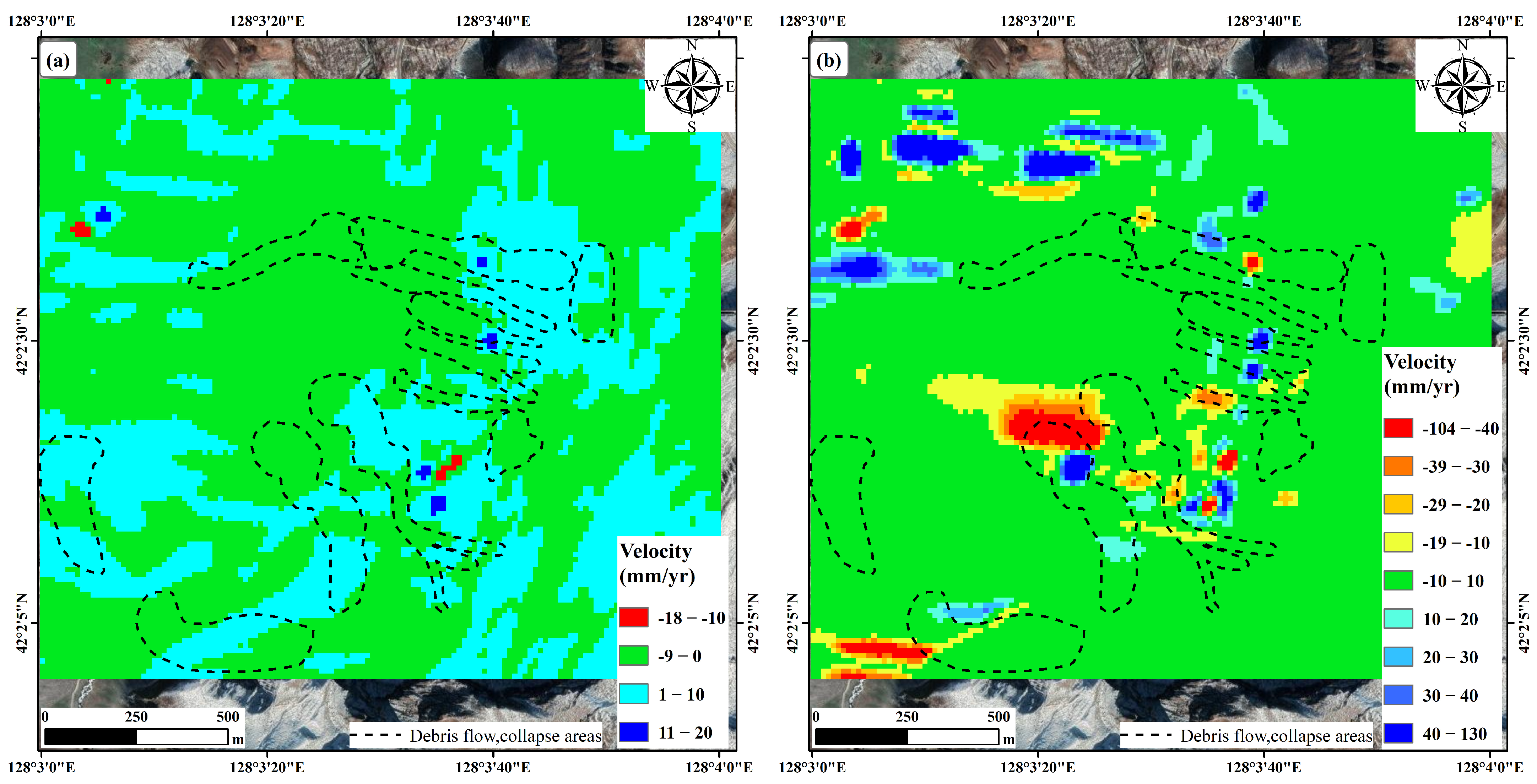
- According to the comparison between the solid washout from the mudflow we calculated, and the loose material source reserves obtained from the survey, the solid washout from a single mudflow is much smaller than the material source reserves. Combined with the analysis of the OT results, even after the occurrence of mudflow, the formation area of multiple mudflows will be recharged by material sources due to the collapse landslide above, and the recharge will be even greater than the consumption. Therefore, the frequency of mudflow outbreaks in the study area may be more frequent in the summer when heavy rainfall is encountered for a long time in the future;
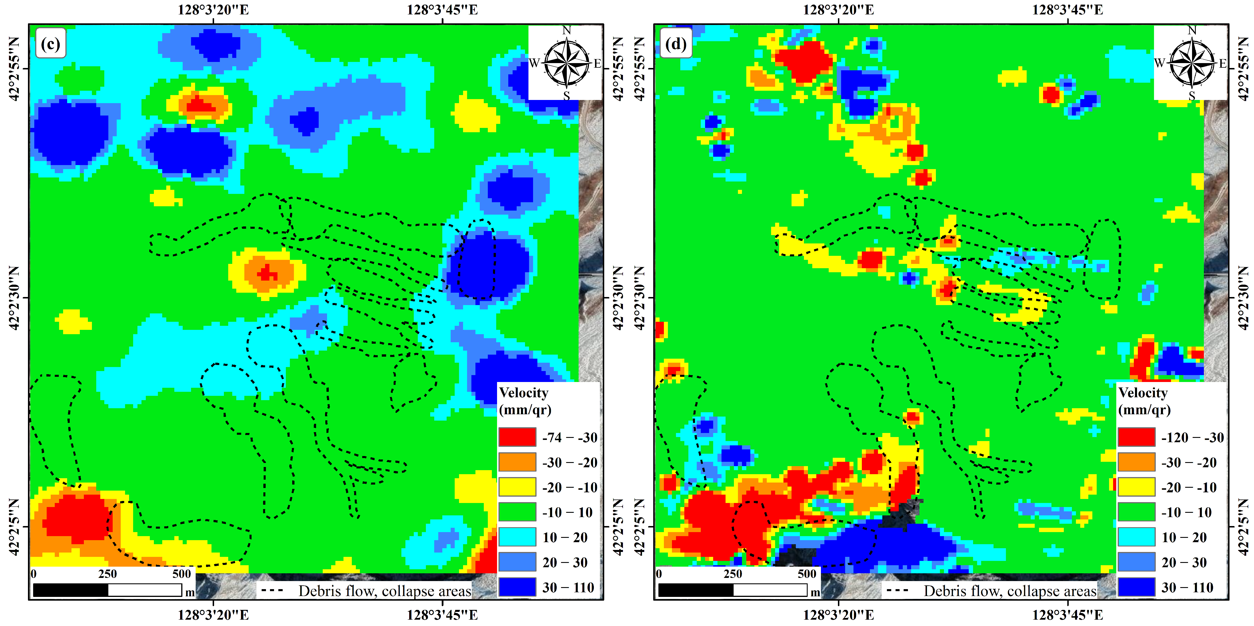
- Although OT is widely used for large gradient deformation, and although we can use it to determine the physical source variability of mudflows in the study area, for different study purposes, the OT results are not completely reliable. For example, as we mentioned in 4.2, we cannot use the OT results alone to delineate the extent of mudflows, and its results are affected by various factors such as vegetation, rainfall and weather. Therefore, in the study of mudslides, it is necessary to combine field surveys or remote sensing images to delineate the extent of mudslides;
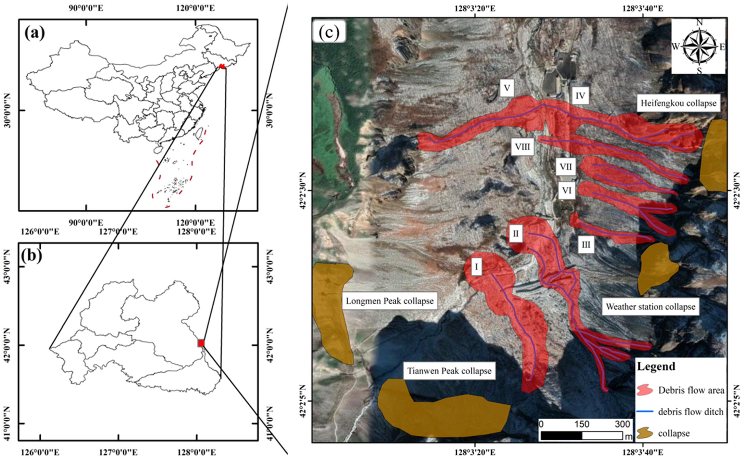
- Combined with remote sensing images, field survey and offset tracking results delineated the mudslide danger zone in the scenic area of the study area. Due to the huge number of visitors in the scenic area—according to our preliminary statistics, the total number of people threatened reached 130,000—it is necessary to do a good job of disaster prevention and mitigation and protection work in the danger zone, especially at the danger zone of the collapse of Longmen Peak, where there have been many incidents of falling rocks injuring people;
- We have used D-InSAR for deformation monitoring after deformation monitoring using offset tracking, a method which, although subject to many factors when deforming large gradients, can be used as a complement to offset-tracking techniques. D-InSAR can operate effectively in areas with slow deformation, and it can be used in combination with offset tracking to obtain more highly accurate surface shape information. We see an opportunity here to develop a hybrid velocity product combining D-InSAR and offset tracking results in the areas where one method or the other- or both-perform best, as suggested by Joughin [54] and Liu [55], in order to obtain more reliable deformation monitoring results;
- In snow and ice covered areas, the effect of snow and ice melting may increase the error of phase untwisting, which, in turn, leads to low-frequency images. Therefore, the monitoring accuracy and results of D-InSAR will be greatly affected during the ice and snow melting in spring, and even if the deformation is small, the monitoring results cannot be fully trusted and need to be used in combination with other methods;
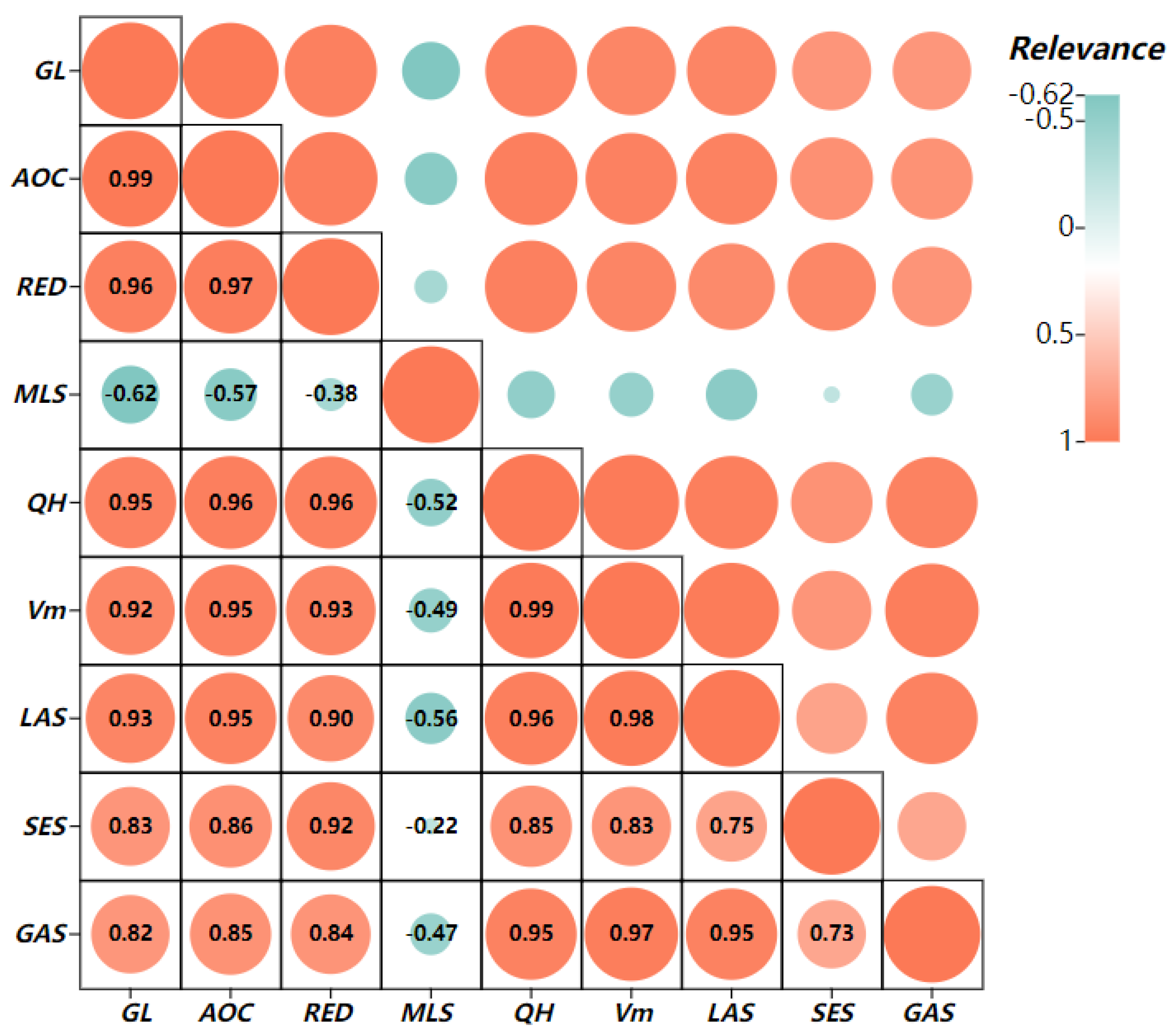
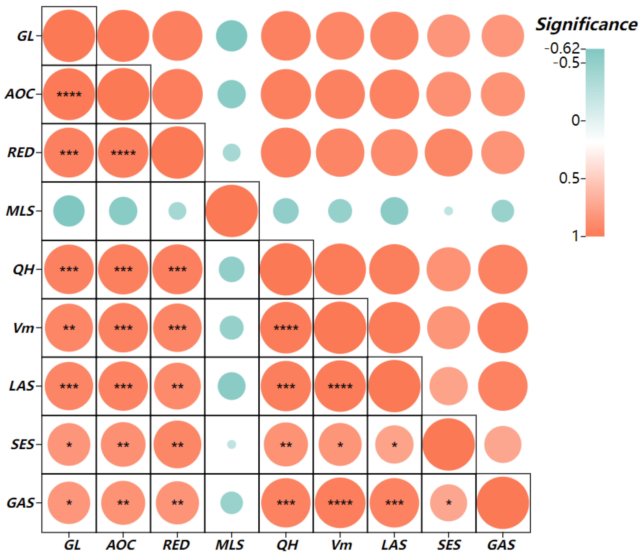
- We learned from analyzing the relationship between various parameters in the watershed, as well as the quantity of washed out debris flow solids, that the source of avalanche-slip accumulation and the source of channel accumulation have a high correlation with the amount of debris flow solids washed out, and we should consider increasing the weight of these two factors when predicting the development trend of debris flow.
Author Contributions
Funding
Institutional Review Board Statement
Informed Consent Statement
Data Availability Statement
Conflicts of Interest
References
- Rickenmann, D.; Zimmermann, M. The 1987 debris flows in Switzerland: Documentation and analysis. Geomorphology 1993, 8, 175–189. [Google Scholar] [CrossRef]
- Costa, J. Physical geomorphology of debris flows. In Developments and Applications of Geomorphology; Springer: Berlin/Heidelberg, Germany, 1984; pp. 268–317. [Google Scholar]
- Hungr, O.; Evans, S.G.; Bovis, M.J.; Hutchinson, J.N. A review of the classi fication of landslides of the flow type. Phys. Geomorphol. Debrisflows 2001, 7, 221–238. [Google Scholar]
- Hungr, O.; Leroueil, S.; Picarelli, L. The Varnes classification of landslide types. Landslides 2014, 11, 167–194. [Google Scholar] [CrossRef]
- Iverson, R.M. The physics of debris flows. Rev. Geophys. 1997, 35, 245–296. [Google Scholar] [CrossRef]
- Innes, J.L. Debris flows. Prog. Phys. Geogr. Earth Environ. 1983, 7, 469–501. [Google Scholar] [CrossRef]
- Cesca, M.; D’Agostino, V. Comparison between FLO-2D and RAMMS in debrisflow modelling: A case study in the Dolomites. WIT Trans. Eng. 2008, 60, 197–206. [Google Scholar]
- De Haas, T.; Braat, L.; Leuven, J.R.F.W.; Lokhorst, I.R. Kleinhans MGEffects of debrisflow composition on runout, depositional mechanisms, and deposit morphology in laboratory experiments. Geophys. Res. Earth Surf. 2015, 120, 1949–1972. [Google Scholar] [CrossRef]
- Ji, F.; Dai, Z.; Li, R. A multivariate statistical method for susceptibility analysis of debris flow in southwestern China. Hazard. Earth Syst. 2020, 20, 1321–1334. [Google Scholar] [CrossRef]
- Viesca, R. Debris flow: Mechanics, prediction and countermeasures by Tamotsu Takahashi. Pure Appl. Geophys. 2008, 165, 995. [Google Scholar] [CrossRef]
- Chen, H.X.; Zhang, L.M.; Chang, D.S.; Zhang, S. Mechanisms and runout characteristics of the rainfall-triggered debris fow in Xiaojiagou in Sichuan Province, China. Nat. Hazard. 2012, 62, 1037–1057. [Google Scholar] [CrossRef]
- Simoni, A.; Mammoliti, M.; Graf, C. Performance of 2D debris fow simulation model RAMMS. Back-analysis of feld events in Italian Alps. Annu. Int. Conf. Geol. Earth Sci. 2012, 20, 1521–1534. [Google Scholar]
- Breien, H.; De Blasio, F.V.; Elverhøi, A.; Høeg, K. Erosion and morphology of a debris flow caused by a glacial lake outburst flood, Western Norway. J. Landslides 2008, 5, 271–280. [Google Scholar] [CrossRef]
- Bel, C.; Li’ebault, F.; Navratil, O.; Eckert, N.; Bellot, H.; Fontaine, F.; Laigle, D. Rainfall control of debris-flow triggering in the Real Torrent, Southern French Prealps. Geomorphology 2017, 291, 17–32. [Google Scholar] [CrossRef]
- Dowling, C.A.; Santi, P.M. Debris flows and their toll on human life: A global analysis of debris-flow fatalities from 1950 to 2011. Nat. Hazard. 2014, 71, 203–227. [Google Scholar] [CrossRef]
- Lee, S.G.; Winter, M.G. The effects of debris flow in the Republic of Korea and some issues for successful risk reduction. Eng. Geol. 2019, 251, 172–189. [Google Scholar] [CrossRef]
- Pastorello, R.; D’Agostino, V.; Hürlimann, M. Debris flow triggering characterization through a comparative analysis among different mountain catchments. Catena 2020, 186, 104–348. [Google Scholar] [CrossRef]
- Bernard, M.; Gregoretti, C. The use of rain gauge measurements and radar data for the model-based prediction of runoff-generated debris-flow occurrence in early warning systems. Water Resour. 2021, 57, e2020WR027893. [Google Scholar] [CrossRef]
- Berti, M.; Bernard, M.; Gregoretti, C.; Simoni, A. Physical interpretation of rainfall thresholds for runoff-generated debris flows. Geophys. Res. Earth Surf. 2017, 125, e2019JF005513. [Google Scholar] [CrossRef]
- Cao, C.; Zhang, W.; Chen, J.; Shan, B.; Song, S.; Zhan, J. Quantitative estimation of debris flow source materials by integrating multisource data: A case study. Eng. Geol. 2019, 291, 106–222. [Google Scholar]
- Caine, N. The rainfall intensity-duration control of shallow landslides and debris flows. Geogr. Ann. Ser. 1980, 62, 23–27. [Google Scholar]
- Dewitte, O.; Jasselette, J.C.; Cornet, Y.; Van Den Eeckhaut, M.; Collignon, A.; Poesen, J.; Demoulin, A. Tracking landslide displacements by multi-temporal DTMs: A combined aerial stereophotogrammetric and LIDAR approach in western Belgium. Eng. Geol. 2008, 99, 11–22. [Google Scholar] [CrossRef]
- Stumpf, A.; Malet, J.-P.; Allemand, P.; Ulrich, P. Surface reconstruction and landslide displacement measurements with Pl’eiades satellite images. Photogramm. Remote Sens. 2004, 95, 1–12. [Google Scholar] [CrossRef]
- Tseng, C.M.; Lin, C.W.; Stark, C.P.; Liu, J.K.; Fei, L.Y.; Hsieh, Y.C. Application of a multi-temporal, LiDAR-derived, digital terrain model in a landslide-volume estimation. Earth Surf. Process. Landf. 2013, 38, 1587–1601. [Google Scholar] [CrossRef]
- Feng, G.; Hetland, E.A.; Ding, X.; Li, Z.; Zhang, L. Coseismic fault slip of the 2008 Mw 7.9 Wenchuan earthquake estimated from InSAR and GPS measurements. Geophys. Res. Lett. 2010, 37, 73–78. [Google Scholar] [CrossRef]
- Strozzi, T.; Luckman, A.; Murray, T.; Wegmuller, U.; Werner, C.L. Glacier motion estimation using SAR offset-tracking proce dures. J. IEEE Trans. Geosci. Remote Sens. 2002, 40, 2384–2391. [Google Scholar] [CrossRef]
- Elliott, J.L.; Freymueller, J.T.; Rabus, B. Coseismic deformation of the 2002 Denali fault earthquake: Contributions from synthetic aperture radar range offsets. Geophys. Res. Solid Earth 2007, 112, B6. [Google Scholar] [CrossRef]
- Wang, T.; Jónsson, S. Improved SAR amplitude image offset measurements for deriving three-dimen sional coseismic displacements. J. Sel. Top. Appl. Earth Obs. Remote Sens. 2015, 8, 3271–3278. [Google Scholar] [CrossRef]
- Schellenberger, T.; Dunse, T.; Kääb, A.; Kohler, J.; Reijmer, C. Surface speed and frontal ablation of kronebreen and kongsbreen, NW Svalbard, from SAR offset tracking. Cryosphere 2015, 9, 2339–2355. [Google Scholar] [CrossRef]
- Wang, C.; Mao, X.; Wang, Q. Landslide displacement monitoring by a fully polarimetric SAR offset tracking method. Remote Sens. 2010, 8, 624. [Google Scholar] [CrossRef]
- Fielding, E.J.; Lundgren, P.R.; Taymaz, T.; Yolsal-Çevikbilen, S.; Owen, S.E. Fault-slip source models for the 2011 M 7.1 van earthquake in Turkeyfrom SARinterferometry, pixel offset tracking, GPS, and seismic waveform analysis. Seismol. Res. 2013, 84, 579–593. [Google Scholar] [CrossRef]
- Bai, C.; Wang, F.; Wang, L.; Xu, C.; Yue, X.; Yang, S.; Wang, P.; Bi, Y.; Wei, H. Dynamic Monitoring of Debris-Covered Glacier Surface Velocity and Ice Thickness of Mt.Tomur, Tian Shan, China. Remote Sens. 2023, 15, 150. [Google Scholar] [CrossRef]
- Yang, H.; Tang, L.; Zhu, H.; Xu, A.; Li, B. A Concise Method for Calibrating the Offset of GPS Precise Satellite Orbit. Remote Sens. 2023, 15, 8. [Google Scholar] [CrossRef]
- Yang, C.; Wei, C.; Ding, H.; Wei, Y.; Zhu, S.; Li, Z. Inversion of Glacier 3D Displacement from Sentinel-1 and Landsat 8 Images Based on Variance Component Estimation: A Case Study in Shishapangma Peak, Tibet, China. Remote Sens. 2023, 15, 4. [Google Scholar] [CrossRef]
- Feng, J.; Qiu, Y.; Dong, C.; Ni, X.; Lin, W.; Teng, H.; Pan, A. Interannual Variabilities of the Southern Bay of Bengal Cold Pool Associated with the El Niño–Southern Oscillation. Remote Sens. 2023, 14, 6169. [Google Scholar] [CrossRef]
- Zhu, Y.; Qiu, H.; Liu, Z.; Wang, J.; Yang, D.; Pei, Y.; Ma, S.; Du, C.; Sun, H.; Wang, L. Detecting Long-Term Deformation of a Loess Landslide from the Phase and Amplitude of Satellite SAR Images: A Retrospective Analysis for the Closure of a Tunnel Event. Remote Sens. 2021, 13, 4841. [Google Scholar] [CrossRef]
- Gray, A.L.; Mattar, K.E.; Vachon, P.W.; Bindschadler, R.; Jezek, K.C.; Forster, R.; Crawford, J.P. InSAR results from the RADARSAT Antarctic Mapping Mission data: Estimation of glacier motion using a simple registration procedure. IGARSS’98. Sensing and Managing the Environment. 1998 IEEE International Geoscience and Remote Sensing. Symp. Proc. 1998, 3, 1638–1640. [Google Scholar] [CrossRef]
- Yoo, J.C.; Han, T.H. Fast normalized cross-correlation. Circuits Syst. Signal Process. 2009, 28, 819–843. [Google Scholar] [CrossRef]
- Jia, H.; Wang, Y.; Ge, D.; Deng, Y.; Wang, R. Improved offset tracking for predisaster deformation monitoring of the 2018 Jinsha River landslide (Tibet, China). Remote Sens. Environ. 2020, 247, 111899. [Google Scholar] [CrossRef]
- Du, S.; Mallorqui, J.J.; Zhao, F. Patch-Like Reduction (PLR): A SAR Offset Tracking amplitude filter for defor mation monitoring. Int. J. Appl. Earth Obs. Geoinf. 2022, 113, 102976. [Google Scholar] [CrossRef]
- Rott, H.; Stuefer, M.; Siegel, A.; Skvarca, P.; Eckstaller, A. Mass fluxes and dynamics of Moreno Glacier, Southern Patagonia Icefield. Geophys. Res. Lett. 1998, 25, 1407–1410. [Google Scholar] [CrossRef]
- Chen, B.; Deng, K.; Fan, H.; Hao, M. Large-scale deformation monitoring in mining area by D-InSAR and 3D laser scanning technology integration. Int. J. Min. Sci. Technol. 2013, 23, 555–561. [Google Scholar] [CrossRef]
- Mura, J.C.; Paradella, W.R.; Gama, F.F.; Silva, G.G.; Galo, M.; Camargo, P.O.; Silva, A.Q.; Silva, A. Monitoring of Non-Linear Ground Movement in an Open Pit Iron Mine Based on an Integration of Advanced DInSAR Techniques Using TerraSAR-X Data. Remote Sens. 2016, 8, 409. [Google Scholar] [CrossRef]
- Debella-Gilo, M.; Kääb, A. Sub-pixel precision image matching for measuring surface displacements on mass movements using normalized cross-correlation. Remote Sens. Environ. 2011, 115, 130–142. [Google Scholar] [CrossRef]
- Cheng, X.Q.; Ma, C.; Kang, J.R.; Zou, Y. Simulation and time series analysis of mining subsidence by integrating DInSAR and PIM technology. J. China Univ. Min. Technol. 2018, 47, 1141–1148. [Google Scholar]
- Pawluszek-Filipiak, K.; Borkowski, A. Integration of DInSAR and SBAS Techniques to Determine Mining-Related Deformations Using Sentinel-1 Data: The Case Study of Rydułtowy Mine in Poland. Remote Sens. 2020, 12, 242. [Google Scholar] [CrossRef]
- Xu, B.; Li, Z.; Zhu, Y.; Shi, J.; Feng, G. SAR Interferometric Baseline Refinement Based on Flat-Earth Phase without a Ground Control Point. Remote Sens. 2020, 12, 233. [Google Scholar] [CrossRef]
- Zhao, X.; Zhou, D.; Fang, J. Satellite-based Studies on Large-Scale Vegetation Changes in China. J. Integr. Plant Biol. 2012, 54, 713–728. [Google Scholar] [CrossRef]
- Mirmohammadian, F.; Asgari, J.; Verhagen, S.; Amiri-Simkooei, A. Multi-GNSS-Weighted Interpolated Tropospheric Delay to Improve Long-Baseline RTK Positioning. Sensors 2022, 22, 5570. [Google Scholar] [CrossRef]
- D’Agostino, V.; Marchi, L. Debris flow magnitude in the eastern italian alps: Data collection and analysis. J. Phys. Chem. Earth 2001, 26, 657–663. [Google Scholar] [CrossRef]
- Bovis, M.J.; Jakob, M. The role of debris supply conditions in predicting debris flow activity. J. Earth Surf. Process. Landf. 1999, 24, 1039–1054. [Google Scholar] [CrossRef]
- Ma, C.; Hu, K.; Tian, M. Comparison of debris-flow volume and activity under different formation conditions. Nat. Hazard. 2013, 67, 261–273. [Google Scholar] [CrossRef]
- Gartner, J.E.; Cannon, S.H.; Santi, P.M.; Dewolfe, V.G. Empirical models to predict the volumes of debris flows generated by recently burned basins in the western U.S. Geomorphology 2008, 96, 339–354. [Google Scholar] [CrossRef]
- Chang, M.; Tang, C.; Van Asch, T.W.; Cai, F. Hazard assessment of debris flows in the Wenchuan earthquake-stricken area, South West China. J. Landslides 2017, 14, 1783–1792. [Google Scholar] [CrossRef]
- Joughin, I. Ice-sheet velocity mapping: A combined interferometric and speckle-tracking approach. Ann. Glaciol. 2002, 34, 195–201. [Google Scholar] [CrossRef]
- Liu, H.X.; Zhao, Z.Y.; Jezek, K.C. Synergistic fusion of interferometric and speckle-tracking methods for deriving surface velocity from interferometric SAR data. IEEE Geosci. Remote Sens. Lett. 2007, 4, 102–106. [Google Scholar] [CrossRef]






| The Serial Number | Ditch Length (km) | Ditch Area (km2) | Relative Elevation Difference (m) | Mean Longitudinal Slope (‰) |
|---|---|---|---|---|
| 1 | 1.53 | 0.48 | 618 | 403 |
| 2 | 1.45 | 0.46 | 664 | 458 |
| 3 | 0.76 | 0.10 | 434 | 569 |
| 4 | 0.80 | 0.10 | 356 | 446 |
| 5 | 0.79 | 0.08 | 390 | 466 |
| 6 | 0.82 | 0.09 | 429 | 522 |
| 7 | 0.80 | 0.07 | 392 | 487 |
| 8 | 0.84 | 0.08 | 393 | 468 |
| Catchment Area F | Value of K |
|---|---|
| F < 5 km2 | K = 0.202 |
| F = 5~10 km2 | K = 0.113 |
| F = 10~100 km2 | K = 0.0378 |
| F > 10~100 km2 | K < 0.0252 |
| Serial Number | Image Acquisition Time | Absolute Orbits | Relative Orbit | Azimuth Angle (°) | Incidence Angle (°) | Satellite Geometry |
|---|---|---|---|---|---|---|
| 01 | 2017/01/01 | 3660 | 134 | 193 | 41 | descending |
| 8910310002 | 2017/03/07 | 4608 | 32 | 193 | 34 | descending |
| 03 | 2017/05/30 | 5833 | 32 | 193 | 34 | descending |
| 04 | 2017/09/03 | 3354 | 32 | 193 | 34 | descending |
| 05 | 2017/11/26 | 4058 | 32 | 193 | 34 | descending |
| 06 | 2017/12/20 | 3660 | 32 | 193 | 34 | descending |
| 07 | 2017/12/27 | 8910 | 134 | 193 | 41 | descending |
| 08 | 2018/03/03 | 9858 | 32 | 193 | 34 | descending |
| Ditch Number | Landslide Accumulation Source (104 m3) | Slope Erosion Source (104 m3) | Ditch Accumulation Source (104 m3) | Total (104 m3) |
|---|---|---|---|---|
| No. 1 ditch | 6.13 | 2.91 | 1.96 | 11 |
| No. 2 ditch | 7.65 | 3.4 | 4.55 | 15.6 |
| No. 3 ditch | 1.7 | 1.8 | 0.19 | 3.69 |
| No. 4 ditch | 2.95 | 0.74 | 1.38 | 5.07 |
| No. 5 ditch | 0.59 | 1.71 | 0 | 2.3 |
| No. 6 ditch | 0.6 | 1.6 | 0 | 2.2 |
| No. 7 ditch | 0.62 | 1.28 | 0 | 1.9 |
| No. 8 ditch | 1.8 | 0.34 | 0.22 | 2.36 |
| total | 21.45 | 12.07 | 8.3 | 44.12 |
| Ditch Number | Total Amount of Debris Flow (104 m3) | Debris Flow Severity (t/m3) | Water Severity (t/m3) | Solid Material Weight of Debris Flow (t/m3) | Solid Material Discharge of Debris Flow (104 m3) |
|---|---|---|---|---|---|
| No. 1 ditch | 0.49 | 1.70 | 1 | 2.50 | 0.23 |
| No. 2 ditch | 0.70 | 1.72 | 1 | 2.50 | 0.34 |
| No. 3 ditch | 0.06 | 1.48 | 1 | 2.50 | 0.02 |
| No. 4 ditch | 0.09 | 1.77 | 1 | 2.50 | 0.04 |
| No. 5 ditch | 0.07 | 1.48 | 1 | 2.50 | 0.03 |
| No. 6 ditch | 0.05 | 1.53 | 1 | 2.50 | 0.02 |
| No. 7 ditch | 0.04 | 1.49 | 1 | 2.50 | 0.01 |
| No. 8 ditch | 0.09 | 1.57 | 1 | 2.50 | 0.03 |
Disclaimer/Publisher’s Note: The statements, opinions and data contained in all publications are solely those of the individual author(s) and contributor(s) and not of MDPI and/or the editor(s). MDPI and/or the editor(s) disclaim responsibility for any injury to people or property resulting from any ideas, methods, instructions or products referred to in the content. |
© 2023 by the authors. Licensee MDPI, Basel, Switzerland. This article is an open access article distributed under the terms and conditions of the Creative Commons Attribution (CC BY) license (https://creativecommons.org/licenses/by/4.0/).
Share and Cite
Yan, J.; Zhang, Y.; Zhang, J.; Chen, Y.; Zhang, Z. Study on the Source of Debris Flow in the Northern Scenic Spot of Changbai Mountain Based on Multi-Source Data. Remote Sens. 2023, 15, 2473. https://doi.org/10.3390/rs15092473
Yan J, Zhang Y, Zhang J, Chen Y, Zhang Z. Study on the Source of Debris Flow in the Northern Scenic Spot of Changbai Mountain Based on Multi-Source Data. Remote Sensing. 2023; 15(9):2473. https://doi.org/10.3390/rs15092473
Chicago/Turabian StyleYan, Jiahao, Yichen Zhang, Jiquan Zhang, Yanan Chen, and Zhen Zhang. 2023. "Study on the Source of Debris Flow in the Northern Scenic Spot of Changbai Mountain Based on Multi-Source Data" Remote Sensing 15, no. 9: 2473. https://doi.org/10.3390/rs15092473
APA StyleYan, J., Zhang, Y., Zhang, J., Chen, Y., & Zhang, Z. (2023). Study on the Source of Debris Flow in the Northern Scenic Spot of Changbai Mountain Based on Multi-Source Data. Remote Sensing, 15(9), 2473. https://doi.org/10.3390/rs15092473


