
BAMFORESTS: Bamberg Benchmark Forest Dataset of Individual Tree Crowns in Very-High-Resolution UAV Images


Abstract
1. Introduction
2. Theoretical Background
2.1. Supervised Deep Learning on Forest Datasets
2.2. Forest Datasets
- Label completeness:
- –
- All tree instances are labeled;
- –
- Only some tree instances are labeled;
- Ground sampling distance (GSD):
- –
- Low resolution (satellite imagery): >1.2 m per pixel;
- –
- High resolution (airplane): 40 cm–6 cm per pixel;
- –
- Very-high resolution (UAVs): <5 cm per pixel;
- Label type:
- –
- Points: the center of each tree crown is labeled;
- –
- Bounding boxes: the outer extents of each tree crown are labeled;
- –
- Polygons:
- ∗
- Semantic segmentation: tree species are labeled on a pixel level;
- ∗
- Instance segmentation: each tree crown is delineated on a pixel level.
3. Dataset
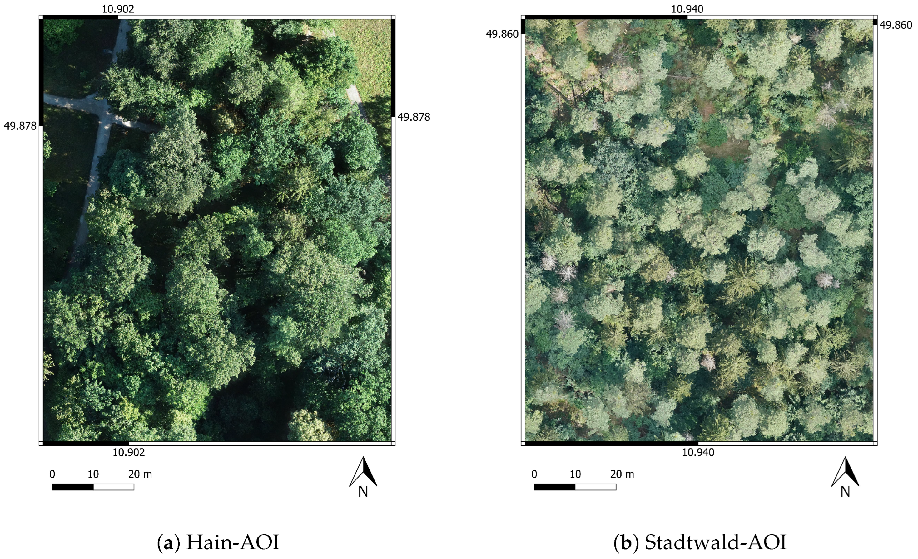
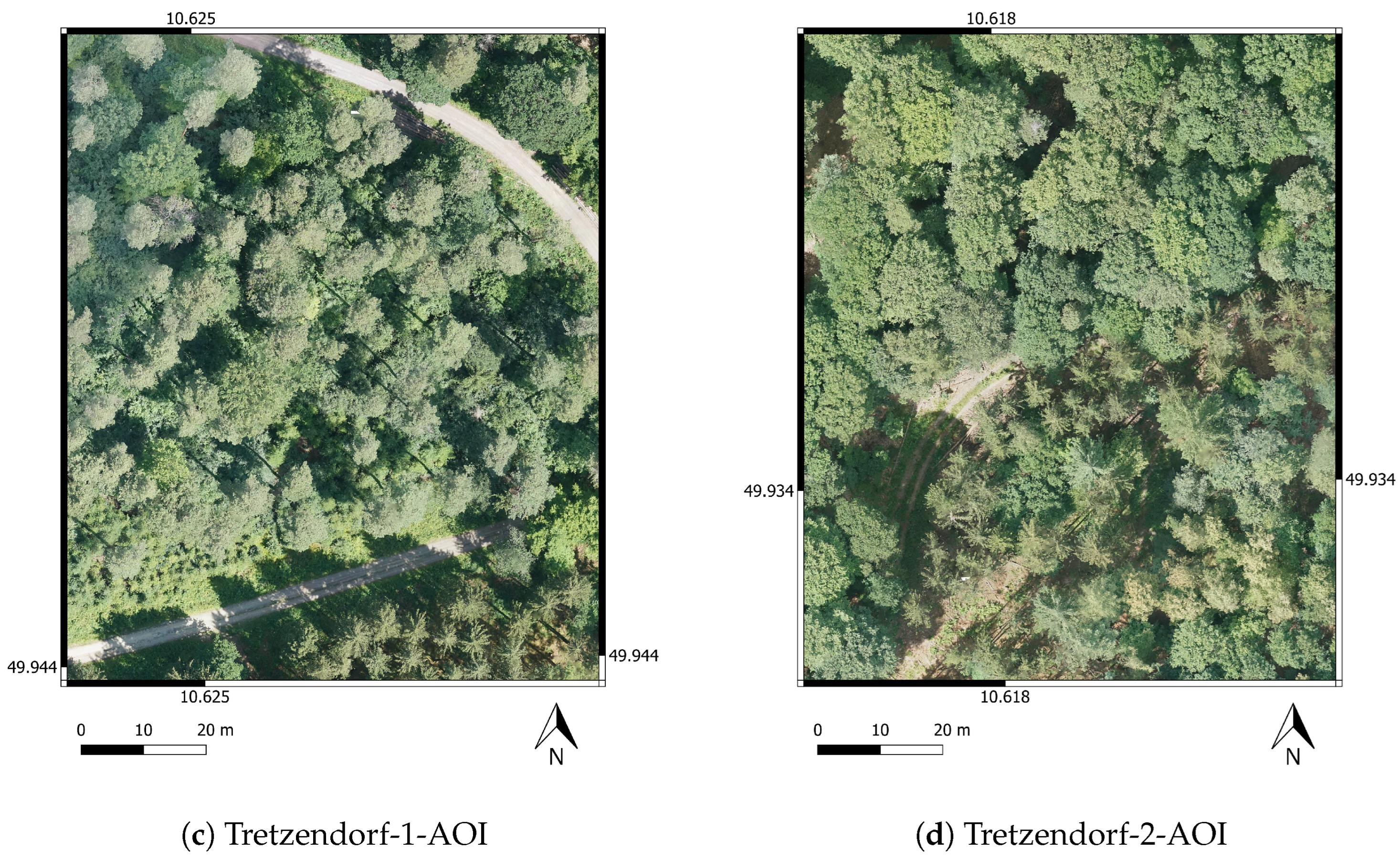
3.1. AOIs
3.2. UAVs and Sensors
3.3. Data Acquisition
3.4. Orthomosaic Generation
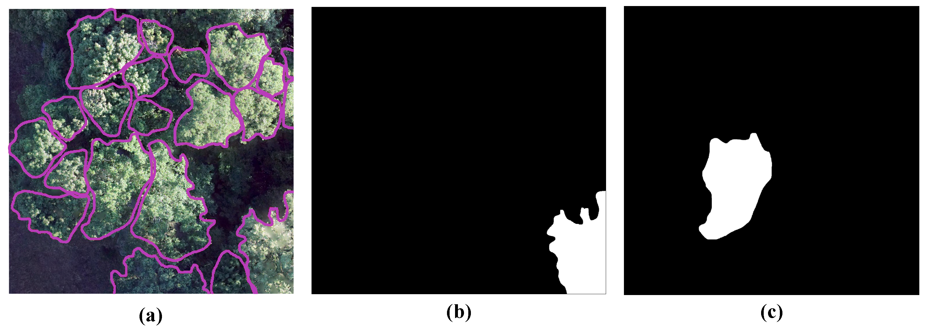
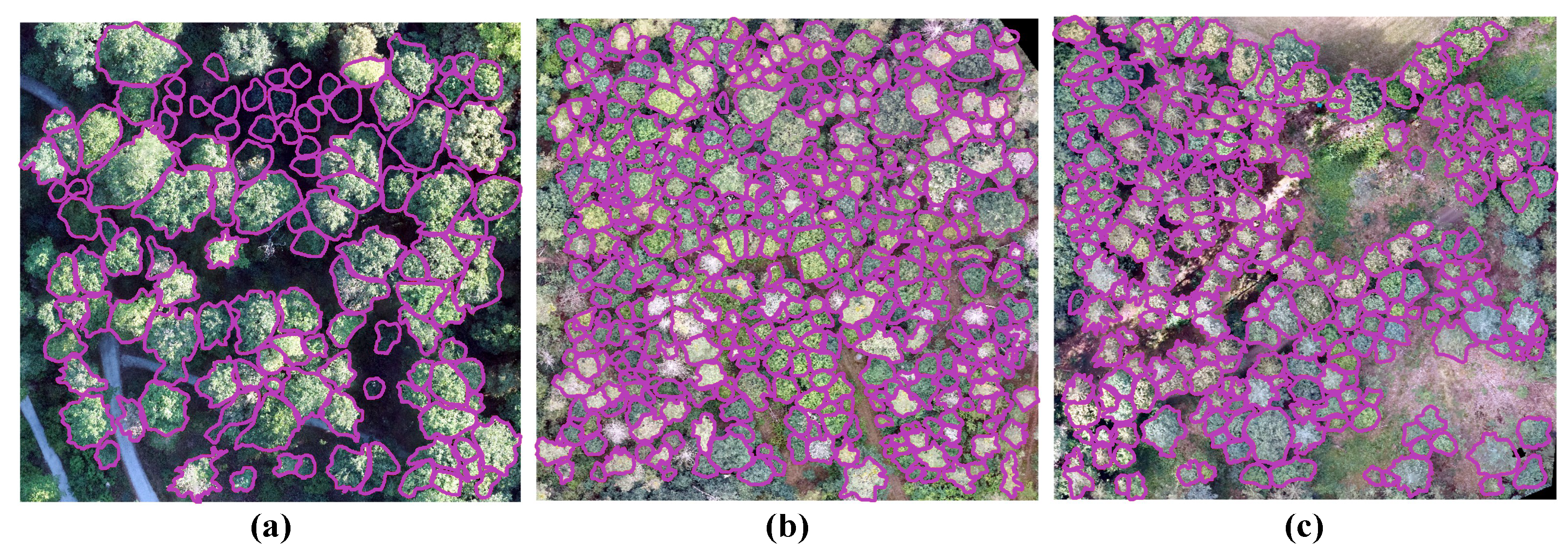
3.5. Labeling Process
3.6. Dataset Metrics
3.7. Benchmark Dataset Split
3.8. COCO Label Generation
3.9. COCO Label Stats
4. Discussion
5. Outlook and Future Work
Author Contributions
Funding
Data Availability Statement
Conflicts of Interest
References
- Trends der Lufttemperatur. Available online: https://www.umweltbundesamt.de/daten/klima/trends-der-lufttemperatur (accessed on 13 March 2024).
- Forzieri, G.; Dakos, V.; McDowell, N.G.; Ramdane, A.; Cescatti, A. Emerging signals of declining forest resilience under climate change. Nature 2022, 608, 534–539. [Google Scholar] [CrossRef] [PubMed]
- Seidl, R.; Schelhaas, M.J.; Rammer, W.; Verkerk, P.J. Increasing forest disturbances in Europe and their impact on carbon storage. Nat. Clim. Change 2014, 4, 806–810. [Google Scholar] [CrossRef] [PubMed]
- Treml, V.; Mašek, J.; Tumajer, J.; Rydval, M.; Čada, V.; Ledvinka, O.; Svoboda, M. Trends in climatically driven extreme growth reductions of Picea abies and Pinus sylvestris in Central Europe. Glob. Change Biol. 2022, 28, 557–570. [Google Scholar] [CrossRef] [PubMed]
- Kehr, R. Possible effects of drought stress on native broadleaved tree species—Assessment in light of the 2018/19 drought. Jahrb. Baumpflege 2020, 2020, 103–107. [Google Scholar]
- Friedlingstein, P.; O’sullivan, M.; Jones, M.W.; Andrew, R.M.; Gregor, L.; Hauck, J.; Le Quéré, C.; Luijkx, I.T.; Olsen, A.; Peters, G.P.; et al. Global carbon budget 2022. Earth Syst. Sci. Data Discuss. 2022, 2022, 1–159. [Google Scholar] [CrossRef]
- Sturrock, R.; Frankel, S.; Brown, A.; Hennon, P.; Kliejunas, J.; Lewis, K.; Worrall, J.; Woods, A. Climate change and forest diseases. Plant Pathol. 2011, 60, 133–149. [Google Scholar] [CrossRef]
- Turner, R.; Smith, P. Mistletoes increasing in eucalypt forest near Eden, New South Wales. Aust. J. Bot. 2016, 64, 171–179. [Google Scholar] [CrossRef]
- Hartmann, H.; Bastos, A.; Das, A.J.; Esquivel-Muelbert, A.; Hammond, W.M.; Martínez-Vilalta, J.; McDowell, N.G.; Powers, J.S.; Pugh, T.A.; Ruthrof, K.X.; et al. Climate change risks to global forest health: Emergence of unexpected events of elevated tree mortality worldwide. Annu. Rev. Plant Biol. 2022, 73, 673–702. [Google Scholar] [CrossRef]
- EFISCEN Inventory Database. Available online: https://efi.int/knowledge/models/efiscen/inventory (accessed on 13 March 2024).
- Kattenborn, T.; Leitloff, J.; Schiefer, F.; Hinz, S. Review on Convolutional Neural Networks (CNN) in vegetation remote sensing. ISPRS J. Photogramm. Remote Sens. 2021, 173, 24–49. [Google Scholar] [CrossRef]
- Gan, Y.; Wang, Q.; Iio, A. Tree crown detection and delineation in a temperate deciduous forest from UAV RGB imagery using deep learning approaches: Effects of spatial resolution and species characteristics. Remote Sens. 2023, 15, 778. [Google Scholar] [CrossRef]
- Ball, J.G.; Hickman, S.H.; Jackson, T.D.; Koay, X.J.; Hirst, J.; Jay, W.; Archer, M.; Aubry-Kientz, M.; Vincent, G.; Coomes, D.A. Accurate delineation of individual tree crowns in tropical forests from aerial RGB imagery using Mask R-CNN. Remote Sens. Ecol. Conserv. 2023, 9, 641–655. [Google Scholar] [CrossRef]
- Weinstein, B.G.; Marconi, S.; Aubry-Kientz, M.; Vincent, G.; Senyondo, H.; White, E.P. DeepForest: A Python package for RGB deep learning tree crown delineation. Methods Ecol. Evol. 2020, 11, 1743–1751. [Google Scholar] [CrossRef]
- Xi, X.; Xia, K.; Yang, Y.; Du, X.; Feng, H. Evaluation of dimensionality reduction methods for individual tree crown delineation using instance segmentation network and UAV multispectral imagery in urban forest. Comput. Electron. Agric. 2021, 191, 106506. [Google Scholar] [CrossRef]
- Weinstein, B. A Benchmark Dataset for Airborne Machine Learning. Available online: https://milliontrees.idtrees.org/ (accessed on 13 March 2024).
- Weinstein, B.G.; Marconi, S.; Bohlman, S.; Zare, A.; White, E. Individual tree-crown detection in RGB imagery using semi-supervised deep learning neural networks. Remote Sens. 2019, 11, 1309. [Google Scholar] [CrossRef]
- Ioannidou, A.; Chatzilari, E.; Nikolopoulos, S.; Kompatsiaris, I. Deep learning advances in computer vision with 3d data: A survey. ACM Comput. Surv. (CSUR) 2017, 50, 1–38. [Google Scholar] [CrossRef]
- Liu, B.; Yu, L.; Che, C.; Lin, Q.; Hu, H.; Zhao, X. Integration and Performance Analysis of Artificial Intelligence and Computer Vision Based on Deep Learning Algorithms. arXiv 2023, arXiv:2312.12872. [Google Scholar] [CrossRef]
- Deng, J.; Dong, W.; Socher, R.; Li, L.J.; Li, K.; Li, F.-F. ImageNet: A large-scale hierarchical image database. In Proceedings of the 2009 IEEE Conference on Computer Vision and Pattern Recognition, Miami, FL, USA, 20–25 June 2009; pp. 248–255. [Google Scholar] [CrossRef]
- Krizhevsky, A.; Sutskever, I.; Hinton, G.E. Imagenet classification with deep convolutional neural networks. Adv. Neural Inf. Process. Syst. 2012, 25. Available online: https://proceedings.neurips.cc/paper_files/paper/2012/file/c399862d3b9d6b76c8436e924a68c45b-Paper.pdf (accessed on 13 March 2024). [CrossRef]
- Lin, T.; Maire, M.; Belongie, S.J.; Bourdev, L.D.; Girshick, R.B.; Hays, J.; Perona, P.; Ramanan, D.; Dollár, P.; Zitnick, C.L. Microsoft COCO: Common Objects in Context. arXiv 2014, arXiv:1405.0312. [Google Scholar]
- Zhao, H.; Morgenroth, J.; Pearse, G.; Schindler, J. A systematic review of individual tree crown detection and delineation with convolutional neural networks (CNN). Curr. For. Rep. 2023, 9, 149–170. [Google Scholar] [CrossRef]
- Fan, W.; Tian, J.; Troles, J.; Döllerer, M.; Kindu, M.; Knoke, T. Comparing Deep Learning and MCWST Approaches for Individual Tree Crown Segmentation. ISPRS Ann. Photogramm. Remote Sens. Spat. Inf. Sci. 2024, X-1-2024, 67–73. [Google Scholar] [CrossRef]
- Schiefer, F.; Kattenborn, T.; Frick, A.; Frey, J.; Schall, P.; Koch, B.; Schmidtlein, S. Mapping forest tree species in high resolution UAV-based RGB-imagery by means of convolutional neural networks. ISPRS J. Photogramm. Remote Sens. 2020, 170, 205–215. [Google Scholar] [CrossRef]
- Rafael Padilla, A.R.; the Hugging Face Team. Open Object Detection Leaderboard. 2023. Available online: https://huggingface.co/spaces/rafaelpadilla/object_detection_leaderboard (accessed on 13 March 2024).
- Image Classification on ImageNet. 2024. Available online: https://paperswithcode.com/sota/image-classification-on-imagenet (accessed on 13 March 2024).
- Yang, K.; Yau, J.; Fei-Fei, L.; Deng, J.; Russakovsky, O. A Study of Face Obfuscation in ImageNet. arXiv 2021, arXiv:2103.06191. [Google Scholar]
- Qin, R.; Liu, T. A Review of Landcover Classification with Very-High Resolution Remotely Sensed Optical Images—Analysis Unit, Model Scalability and Transferability. Remote Sens. 2022, 14, 646. [Google Scholar] [CrossRef]
- Schiefer, F.; Frey, J.; Kattenborn, T. FORTRESS—Forest Tree Species Segmentation in Very-High Resolution UAV-Based Orthomosaics; Karlsruhe Institute of Technology: Karlsruhe, Germany, 2022. [Google Scholar] [CrossRef]
- Cloutier, M.; Germain, M.; Laliberté, E. Quebec Trees Dataset; Zenodo: Geneva, Switzerland, 2023. [Google Scholar] [CrossRef]
- Cloutier, M.; Germain, M.; Laliberté, E. Influence of Temperate Forest Autumn Leaf Phenology on Segmentation of Tree Species from UAV Imagery Using Deep Learning. bioRxiv 2023, 1–45. [Google Scholar] [CrossRef]
- Kruse, S.; Farkas, L.; Brieger, F.; Geng, R.; Heim, B.; Pestryakova, L.A.; Zakharov, E.S.; Herzschuh, U.; van Geffen, F. SiDroForest: Orthomosaics, SfM point clouds and products from aerial image data of expedition vegetation plots in 2018 in Central Yakutia and Chukotka, Siberia, 2022. Earth Syst. Sci. Data 2022, 14, 4967–4994. [Google Scholar] [CrossRef]
- Jansen, A.; Nicholson, J.; Esparon, A.; Whiteside, T.; Welch, M.; Tunstill, M.; Paramjyothi, H.; Gadhiraju, V.; van Bodegraven, S.; Bartolo, R. A Deep Learning Dataset for Savanna Tree Species in Northern Australia; Zenodo: Geneva, Switzerland, 2022. [Google Scholar] [CrossRef]
- Jansen, A.J.; Nicholson, J.D.; Esparon, A.; Whiteside, T.; Welch, M.; Tunstill, M.; Paramjyothi, H.; Gadhiraju, V.; van Bodegraven, S.; Bartolo, R.E. Deep Learning with Northern Australian Savanna Tree Species: A Novel Dataset. Data 2023, 8, 44. [Google Scholar] [CrossRef]
- Troles, J.; Nieding, R.; Simons, S.; Schmid, U. Task Planning Support for Arborists and Foresters: Comparing Deep Learning Approaches for Tree Inventory and Tree Vitality Assessment Based on UAV-Data. In Innovations for Community Services; Krieger, U.R., Eichler, G., Erfurth, C., Fahrnberger, G., Eds.; Springer: Cham, Switzerland, 2023; pp. 103–122. [Google Scholar]
- Kattenborn, T.; Schiefer, F.; Frey, J.; Feilhauer, H.; Mahecha, M.D.; Dormann, C.F. Spatially autocorrelated training and validation samples inflate performance assessment of convolutional neural networks. ISPRS Open J. Photogramm. Remote Sens. 2022, 5, 100018. [Google Scholar] [CrossRef]
- Lin, T.Y.; Maire, M.; Belongie, S.; Hays, J.; Perona, P.; Ramanan, D.; Dollár, P.; Zitnick, C.L. Microsoft coco: Common objects in context. In Proceedings of the Computer Vision—ECCV 2014: 13th European Conference, Zurich, Switzerland, 6–12 September 2014; Proceedings, Part V 13. Springer: Berlin/Heidelberg, Germany, 2014; pp. 740–755. [Google Scholar]


| BAMFORESTS | FORTRESS [30] | Quebec Trees Dataset [31,32] | SiDroForest [33] | Name NA [34,35] | |
|---|---|---|---|---|---|
| GSD | 1.61 cm–1.81 cm | <1.35 cm | 1.81 cm–2.02 cm | 3 cm | 1.70 cm–2.00 cm |
| Labeled Area | 105 ha | 47 ha | 44 ha | 13.25 ha | 7ha |
| N of Labels | 27,160 | – | 22,933 | 872 (19,342 *) | 2547 |
| Label Type | Polygons | Polygons | Polygons | Polygons | Polygons |
| Segmentation Type | Instance segmentation | Semantic segmentation | Instance segmentation | Instance segmentation | Instance segmentation |
| Label Completeness | Yes | Yes | Yes | No | Yes |
| Acquisition Period | Jul 2022 – Aug 2022 | Mar 2017 – Sep 2019 | May 2021 – Oct 2021 | Jul 2018 – Aug 2018 | Apr 2021 – Jun 2021 |
| Region | Bavaria, Germany | Baden- Württemberg, Germany | Quebec, Canada | Yakutia and Chukotka, Siberia | Northern Territory, Australia |
| Train-Set | Val-Set | Test-Set-2 | Test-Set-1 | |
|---|---|---|---|---|
| N of shapes | 17,212 | 4390 | 3580 | 1978 |
| Pinus | 36.23% | 31.94% | 27.54% | 1.11% |
| Fagus | 23.11% | 20.71% | 23.10% | 23.96% |
| Quercus | 23.30% | 20.27% | 22.43% | 19.01% |
| Picea | 5.53% | 7.22% | 9.11% | 1.06% |
| Larix | 2.70% | 1.75% | 2.21% | 1.26% |
| Pseudotsuga | 1.12% | 1.80% | 1.20% | 0.15% |
| Abies | 1.19% | 1.12% | 1.01% | 0.00% |
| Other | 6.83% | 15.19% | 13.41% | 52.88% |
| Vital | 86.34% | 84.99% | 83.97% | 91.20% |
| Degrading | 11.88% | 12.35% | 13.18% | 8.49% |
| Dead | 1.78% | 2.67% | 2.85% | 0.30% |
| Size | Number of Images | Number of Annotations | ||||||
|---|---|---|---|---|---|---|---|---|
| Train | Val | Test-Set-1 | Test-Set-2 | Train | Val | Test-Set-1 | Test-Set-2 | |
| 1024 | 7521 | 2008 | 1675 | 1668 | 96,908 | 25,316 | 12,843 | 20,332 |
| 2048 | 1439 | 382 | 313 | 322 | 58,235 | 15,180 | 6720 | 12,321 |
Disclaimer/Publisher’s Note: The statements, opinions and data contained in all publications are solely those of the individual author(s) and contributor(s) and not of MDPI and/or the editor(s). MDPI and/or the editor(s) disclaim responsibility for any injury to people or property resulting from any ideas, methods, instructions or products referred to in the content. |
© 2024 by the authors. Licensee MDPI, Basel, Switzerland. This article is an open access article distributed under the terms and conditions of the Creative Commons Attribution (CC BY) license (https://creativecommons.org/licenses/by/4.0/).
Share and Cite
Troles, J.; Schmid, U.; Fan, W.; Tian, J. BAMFORESTS: Bamberg Benchmark Forest Dataset of Individual Tree Crowns in Very-High-Resolution UAV Images. Remote Sens. 2024, 16, 1935. https://doi.org/10.3390/rs16111935
Troles J, Schmid U, Fan W, Tian J. BAMFORESTS: Bamberg Benchmark Forest Dataset of Individual Tree Crowns in Very-High-Resolution UAV Images. Remote Sensing. 2024; 16(11):1935. https://doi.org/10.3390/rs16111935
Chicago/Turabian StyleTroles, Jonas, Ute Schmid, Wen Fan, and Jiaojiao Tian. 2024. "BAMFORESTS: Bamberg Benchmark Forest Dataset of Individual Tree Crowns in Very-High-Resolution UAV Images" Remote Sensing 16, no. 11: 1935. https://doi.org/10.3390/rs16111935
APA StyleTroles, J., Schmid, U., Fan, W., & Tian, J. (2024). BAMFORESTS: Bamberg Benchmark Forest Dataset of Individual Tree Crowns in Very-High-Resolution UAV Images. Remote Sensing, 16(11), 1935. https://doi.org/10.3390/rs16111935