Technical Note

An Ontology for Describing Wind Lidar Concepts

1
Institute of Aircraft Design, University of Stuttgart, Allmandring 5b, 70569 Stuttgart, Germany
2
Fraunhofer IWES, 27572 Bremerhaven, Germany
3
Wood Renewables, Floor 2 St Vincent Plaza, 319 St Vincent Street, Glasgow G2 5LP, UK
4
Enlight Renewable Energy, Ha’amal St., Afek Industrial Park 13, Rosh Ha’ayin 4809249, Israel
5
TGU Enerlace, TTI GmbH, Nobelstrasse 15, 70569 Stuttgart, Germany
*
Author to whom correspondence should be addressed.
Remote Sens. 2024, 16(11), 1982; https://doi.org/10.3390/rs16111982
Submission received: 8 May 2024 / Revised: 23 May 2024 / Accepted: 27 May 2024 / Published: 31 May 2024

Abstract

:
This article reports on an open-source ontology that has been developed to establish an industry-wide consensus on wind lidar concepts and terminology. The article provides an introduction to wind lidar ontology, provides an overview of its development, and provides a summary of its aims and achievements. The ontology serves both reference and educational purposes for wind energy applications and lidar technology. The article provides an overview of the creation process, the outcomes of the project, and the proposed uses of the ontology. The ontology is available online and provides standardisation of terminology within the lidar knowledge domain. The open-source framework provides the basis for information sharing and integration within remote sensing science and fields of application.

1. Introduction

Many aspects of wind resource assessment and inflow characterization require accurate measurement of wind speed, wind direction, and turbulence. Wind measurement data can be provided by meteorological mast instrumentation or remote sensing devices. In recent years, measurement of wind speeds with lasers, based upon the lidar (light detection and ranging) system, has provided a modern alternative to the traditional meteorological mast instrumentation. Wind lidar makes use of the principle of optical Doppler shift between the reference radiation and radiation backscattered by aerosol particles to measure radial wind velocities at distances up to several kilometers [1,2,3,4]. In fields such as aviation, climatology, satellite-based measurements, and especially wind energy, there has been a general move towards the adoption of lidar as a cost-effective, self-contained, and adaptable solution to wind measurement. The use of wind lidars is now widely accepted within the wind energy sector, and there has been an associated increase in the technological development of lidar devices, in use cases, and incorporation within a number of IEC standards [5,6,7].
The development of new sensors and the accessibility of data sets are significantly transforming both the theory and practice of remote sensing. The interest in wind lidar has led to it becoming a research field in its own right, and as a result, there have been a multitude of technical advancements and a corresponding plethora of lidar-specific concepts and terminology. Further, lidar manufacturers use a variety of different concept definitions, conventions, and data formats. As a result, there exist many difficulties and challenges in communication and lidar knowledge transfer, which may be the case in particular for early-stage researchers and engineers. This situation has given rise to the need for a system to ensure consistency and comprehension within the field.
To address these issues, academia and industry have been working towards consensus and standardisation, and several examples are notable: The global initiative project e-Wind Lidar [8] focused on the development of wind lidar community-based tools and data standards and published a lidar data form to make them findable, accessible, interoperable and reusable (FAIR) [9]; the IEA Wind TCP Task 52 [10] investigates the challenges to the large-scale adoption of wind lidar and is the successor to IEA Wind TCP Task 32, which set out to identify and mitigate the barriers to the adoption of wind lidar [11]. The OpenLidar project [12]—coordinated by the Stuttgart Chair of Wind Energy—developed an architecture for an open-source remote wind sensing lidar that can be used for teaching, research, and product development. Marykovskiy et al. [13] recognised the need to create value from the data available within the wind energy domain and addressed the challenges faced by wind energy domain experts in converting data into domain knowledge and integration with other sources of knowledge. Their work presents an extensive overview of existing wind energy domain semantic models (i.e., ontologies, taxonomies, schemas, etc.) and highlights the role of knowledge engineering within the digital transformation of the wind energy sector.
While these initiatives have been successful, further effort is required to capitalise on their achievements and bring further consensus and standardisation within a growing lidar community. In recognition of this, an open-source ontology has been developed with the aim of establishing an industry-wide consensus on wind lidar concepts and terminology and their relationships. An ontology defines a common vocabulary within a domain, providing a means to share information within the domain, and includes machine-interpretable definitions of fundamental concepts and the relations among them. Many disciplines now develop standardised ontologies that domain experts can use to share and annotate information in their fields [14]. An ontology serves several purposes: sharing the common understanding of the structure of information; making the domain assumptions explicit; and enabling reuse and analysis of the domain knowledge.
The wind lidar ontology [15] was created as a sub-task of the IEA Wind TCP Task 32 and has been taken on, as already mentioned, by a multi-disciplinary group of academics and industry engineers. This has resulted in the online publication of the latest version of the wind lidar ontology [16]. The wind lidar ontology provides an introduction to the fundamental concepts and terminology relating to lidar hardware and software, lidar installation and measurement, data generation, processing, and analysis. The ontology provides guidelines for a common conceptual architecture for lidar design, modelling, and analysis. The ontology includes the lidar module design according to the OpenLidar Architecture [12], atmospheric parameters, data configuration, and measurement principles. The development of knowledge-driven approaches is considered one of the most important directions of research by the remote sensing community [17]. It is hoped that the ontology will play a part in the development of an industry-wide consensus on lidar concepts and the standardisation of lidar terminology. The ontology is well placed to facilitate reuse of the domain knowledge and collaboration amongst researchers and engineers.
The wind lidar ontology scope includes wind energy applications and lidar technology. The wind lidar ontology has been developed as an open-source code repository with the purpose of allowing free access to users, with options to contribute and redistribute content. The wind lidar ontology serves several purposes: a reference source and dictionary for users, and will be of particular use for new entrants to the field of wind energy; a variable definition reference for datasets for original equipment manufacturers (OEMs) delivering data to clients; an input resource for wind modelling and lidar simulations. As an open-source code repository, the wind lidar ontology will be subject to ongoing development, with individual releases identified with release version numbers. The definitions are available to be downloaded from the code repository.
It is acknowledged that a number of related ontologies have been proposed within the wider wind science community. For instance, previous works on digital twins and digitalisation have provided a platform to develop common ontologies and taxonomies within fields related to wind energy. Using the Digital Twins Definition Language (DTDL) and Common Information Model (CIM), an energy grid ontology was developed by Microsoft in cooperation with other industrial partners [18]. However, this ontology is very generic in nature and is not directly applicable to remote sensing using lidar for wind energy purposes. Küçük and Küçük [19] developed OntoWind, a high-level wind energy ontology aimed at providing a consensual definition of wind energy terms but does not provide details of remote sensing terms. The data format developed as a part of the European Aerosol Research Lidar Network (EARLINET) [20] is based on a common vocabulary agreed upon by the participating network, but is limited to atmospheric aerosols. The ESIP lidar cluster [21] hosts ontologies and vocabularies for lidar-related terms in Earth science research and is open for the public to contribute; however, most of the ontologies focus on the numerical modelling vocabularies or on electronic aspects related to wind energy measurement.
It is intended that the development of the wind lidar ontology addresses the aforementioned perceived issues and challenges relating to lidar knowledge within the wind lidar field. This article provides an introduction to the wind lidar ontology and provides an overview of its structure and development. Section 2 provides an overview of the ontology methodology. The results are presented in Section 3 and are discussed in Section 4. The general outlook for future applications is presented in Section 5.

2. Methodology

The processes and structures underlying the construction and development of the wind lidar ontology are outlined in this section.
In view of the need to establish an industry-wide consensus on wind lidar concepts and terminology and their relationships, the IEA Wind TCP Task 52, and particularly the Wind Lidar Ontology Working Group [22] brought together a variety of researchers and industry stakeholders to collaborate on the standardisation of lidar knowledge. The core team was assembled with experts possessing diverse backgrounds within related domains, yet unified in purpose, to foster a synergistic collaboration. This assemblage comprises representatives from the Fair Data Collective initiative, industrial entities, and academic institutions, including the Stuttgart Wind Energie (SWE) institute at the University of Stuttgart and the Fraunhofer Institute for Wind Energy Systems (IWES). Tasked in accordance with their respective proficiencies, these stakeholders collectively contributed to the development of a comprehensive framework, the conceptualization of the ontology, and the delineation of lidar concepts. This multi-disciplinary approach allowed for enrichment from diverse perspectives, collaboratively addressing the varied needs of industry and academia encountered during the project.
The Wind Lidar Ontology Working Group carried out the following steps to develop the Wind Lidar Ontology:
  • Determine the optimal data model format for saving vocabularies and ensuring accessibility.
  • Populate the concepts and definitions during collaborative discussions.
  • Translate the concept definitions into a number of languages.
  • Provide open-source tools to facilitate dissemination within the wider community.

2.1. Data Model Format

Well-defined data models were employed in consensus to document and maintain the ontology. These data models should ideally be a mixture of human- and machine-readable data models that can be presented to users via different interfaces, as required. In the current context, this is achieved using the Resource Description Framework (RDF) [23] and the Simple Knowledge Organisation System (SKOS) [24].
A controlled vocabulary is a carefully selected list of terms within a specific domain of knowledge that are used to tag units of information so that they may be retrieved by a search. Metadata may be specified in accordance with a controlled vocabulary, providing a clear and concise representation of data sets and allowing data to be structured, stored, maintained, and shared in a consistent manner. Each item within the controlled vocabulary may be regarded as a concept within the specific domain of knowledge.
RDF is a standard model for data interchange on the Web. It is commonly used to model a controlled vocabulary and define properties, relationships, constraints, and axioms among its concepts. It therefore offers the opportunity to digitalise, express, and handle knowledge organisation systems in a machine-readable format. Similarly, SKOS offers standards to create data models for metadata and, jointly with RDF, facilitates the provision of standardised data organisation models to server machines.
A taxonomy is a type of controlled vocabulary in which concepts are related in a hierarchical order or sorted into categories. An ontology is a type of controlled vocabulary that identifies and distinguishes concepts and their relationships.
The first step in building a lidar taxonomy is to create a list of terms, or concepts, related to the wind lidar knowledge domain. To do so, the authors followed the “expert elicitation” approach to establish a consensus position. In this approach, experts in the relevant topics gathered in a collaborative way to define the hierarchy of terms and concepts [25]. Figure 1 illustrates the highest levels of the lidar taxonomy, from the broadest term “wind lidar” to the narrower terms.

2.2. Lidar Concepts

When the lidar concepts are endowed with extended information and their interrelationships specified, the lidar taxonomy becomes a wind lidar ontology. The Wind Lidar Ontology Working Group, encompassing multi-disciplinary fields of knowledge, contributed to the definition of the concepts, the vocabularies, the metadata, and the relationships through intensive discussions organised by IEA Wind TCP Task 52.

2.3. Translation

The participants in the working group encompass a wide range of cultural and regional backgrounds, facilitating direct translation between multiple European languages and Chinese language by native speakers.

2.4. Tools and Implementation

The wrappers sheet2rdf [26,27] and OntoStack [28] have been used to orchestrate the framework necessary to deploy the wind lidar ontology. The ontology is deployed by means of a combination of several tools brought together using GitHub Actions [29], which enable automatic compilation and deployment. The workflow is as follows:
  • Input data sheet: The input data sheet consists of a Google Sheets spreadsheet stored in Google Drive. The Google sheet is used as the graphical user interface (GUI) to edit the ontology, as the GUI simplifies collaboration compared to working on the machine-readable SKOS or RDF formats. The spreadsheet has been populated with the lidar concepts and the related descriptive metadata considered by the authors to be most relevant for the wind lidar community. The source files for the wind lidar ontology and the spreadsheet are hosted in the repository IEA-Wind-Task-32/wind-lidar-ontology [30]. The Google spreadsheet format is read and manipulated by sheet2rdf (see below) and converted to RDF, facilitating its use as an online searchable asset.
  • sheet2rdf: The sheet2rdf [26,27] framework builds on the excel2rdf [31] workflow, enabling the acquisition and transformation of data sheets into RDF [32]. The specific sheet2rdf instance used in the present work is available in a GitHub repository created by the FAIR Data Collective [33]. It contains the main functions that enable the conversion of the ontology information in the Google spreadsheet into machine-actionable RDF format, following SKOS standards. The sheet2rdf framework internally evaluates the quality of the SKOS concept scheme using qSKOS [34] and deploys the RDF-formatted ontology to OntoStack.
    sheet2rdf is a combination of software used to create a configurable automated process allocated as a GitHub Action workflow in [33]. The workflow can be manually triggered to update changes in the server.
  • OntoStack: The OntoStack framework [28] is a set of tools combined for the purpose of handling vocabularies and their RDF properties, such as those yielded by sheet2rdf, rendering them in human- and machine-readable formats, and facilitating the deployment and visualisation of the wind lidar ontology. The wind lidar ontology is an instance of OntoStack, and its online visualisation is hosted by the Wind and Energy Systems Department at the Technical University of Denmark (DTU). The wrapper OntoStack gathers functionalities from several tools enumerated here below [32]:
    • Jena Fuseki [35]: a graph database based on SPARQL, a standard query language and protocol for linked open data on the web [36] that allows users to store and handle data in RDF format.
    • Skosmos [37]: a web-based tool providing services for accessing controlled vocabularies.
    • Træfik [38]: an open-source edge router responsible for proper serving of URL requests.

3. Results

The details of the wind lidar ontology development procedure are outlined, and the structure and intended uses of the GitHub Wind Lidar Ontology Tool are illustrated.

3.1. Wind Lidar Ontology

Structurally inspired by the OpenLidar Architecture, the wind lidar ontology provides a dedicated list of concepts and definitions for supporting the development of modular tools and processes for wind lidars. The selection and definition of the concepts included in the wind lidar ontology are the results of the joint effort and consensus of wind lidar experts, combining the information that describes the data and its associated metadata in a way that meets the needs and requirements of both academia and industry.
The development of the wind lidar ontology to its current state consisted of three main phases:
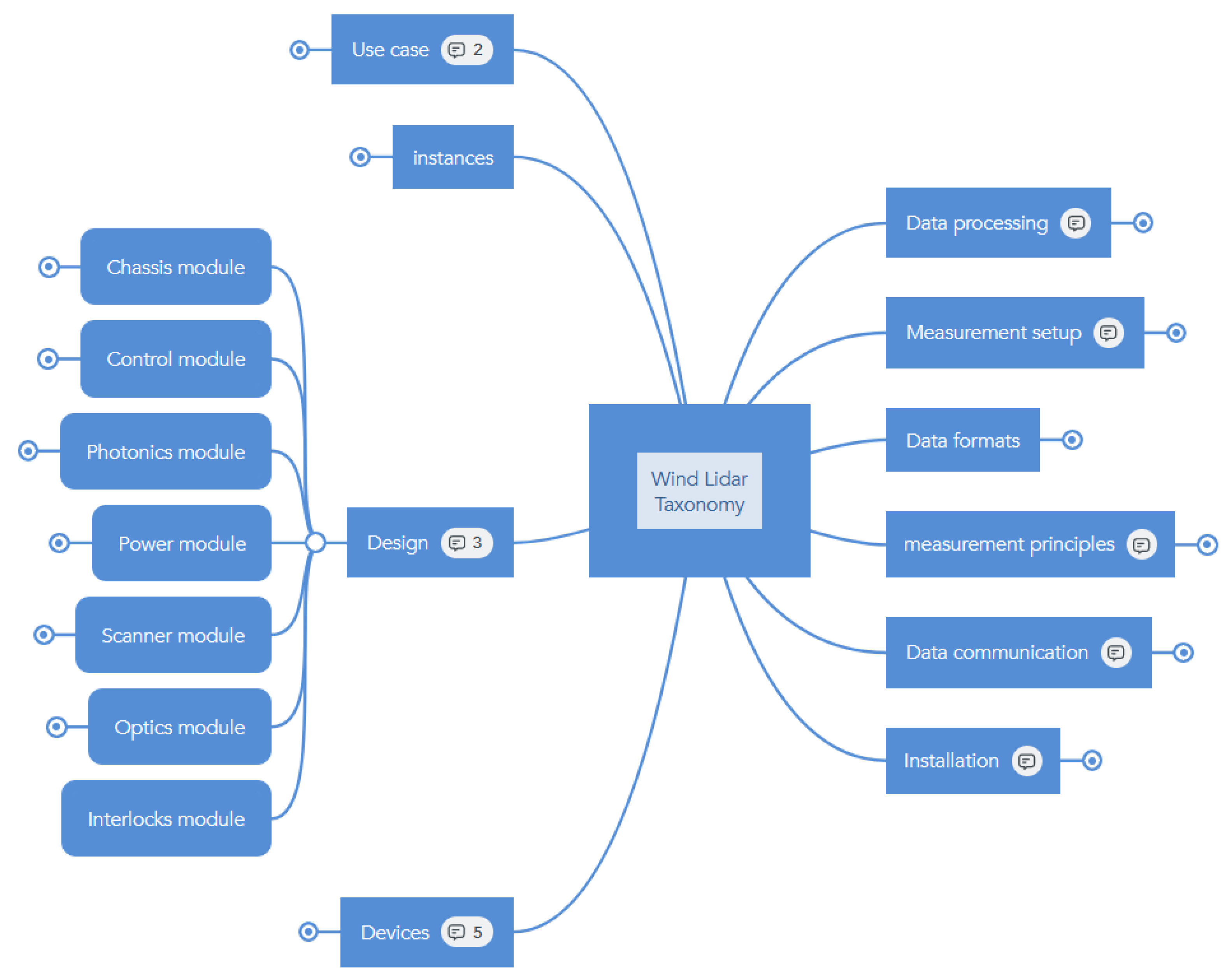
  • Defining the main structure of the ontology. This involved establishing the main nodes and relationships among them. The first, second, and third wind lidar ontology hierarchical levels are shown in Figure 1.
  • Parent-child relationships among the concepts were fully defined, as were possible transitive relationships between tuples.
  • Lidar concepts were assigned according to the authors’ expertise, and the lidar concept definitions and terminology were duly specified. These were subjected to the scrutiny of all members of the ontology group until a consensus was reached. Native speakers proficient in each language provided the translation from the original English version.
Hosting for the online deployment is provided by the Technical University of Denmark (DTU) as an OntoStack instance in the form of a look-up table [30]. The wind lidar ontology homepage includes high-level information about the ontology as well as direct links to the lidar concepts themselves.
The wind lidar ontology and its contents may be explored both alphabetically and hierarchically. The entries within the online version of the ontology contain the fields included in Table 1. A l t e r n a t i v e l a b e l contains information about the alternative names associated with a particular lidar term. Each ontology concept has been unambiguously defined and labelled. The labelling has been aligned with the domain of knowledge (for instance, the V e l o c i t y A z i m u t h D i s p l a y concept has been labelled as VAD, as it is commonly referred to within the lidar community), and the resulting alternative label can serve either for querying information within the framework or to be downloaded and integrated into digital workflows or codes.
Queried information is available for download from the DTU server in three different serialisation formats, namely RDF/HTML, Turtle, and Json, depending on user preferences. Section 3.2 presents a Python-based in-house method for downloading and coupling ontology terms to external digital workflows.

3.2. The Github Wind Lidar Ontology Tool

The wind lidar concepts and terminology were established according to the process outlined in the Methodology section, in which opinions were garnered in order to reach a consensus on the content of the wind lidar ontology. At that stage, a tool was developed to enable the application of metadata to data sets and allow standardisation across various application domains in wind energy. The GitHub Wind Lidar Ontology Tool is based on tools developed by the FAIR Data Collective discussed in Section 2.4, and is openly available at the IEA Wind TCP Task 52 GitHub repository [39].
There are two general approaches to extracting the content of the wind lidar ontology for use within external software applications.
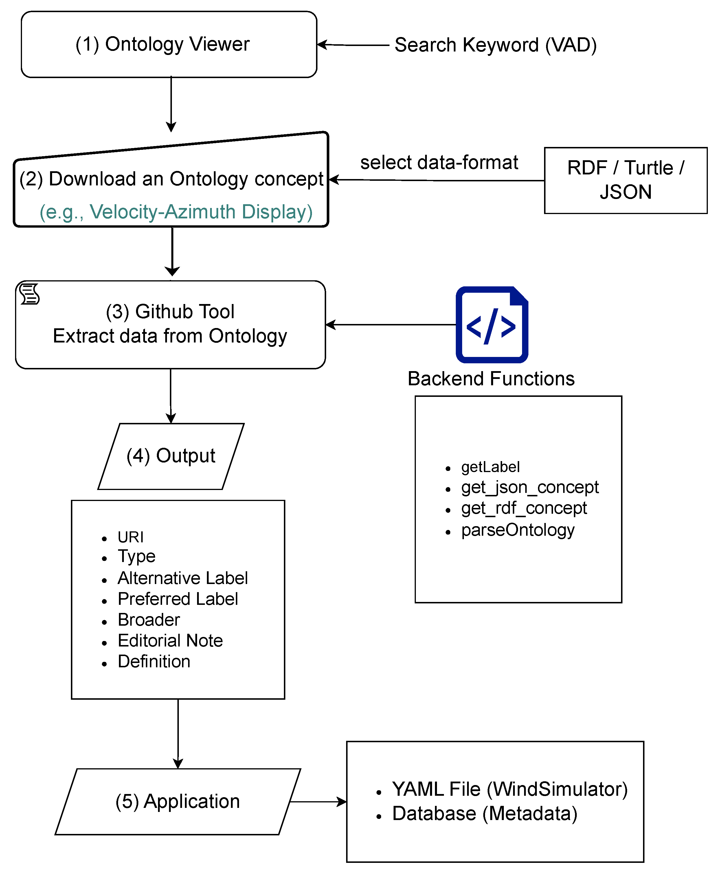
  • Download individual, specific keywords from the webserver-based Wind Lidar Ontology database in the available file formats: RDF; Turtle; JSON.
  • Directly access the existing wind lidar ontology database file from the GitHub repository. The database may be accessed and filtered through a programming tool, such as Python, for specific keywords.
An example is presented to illustrate the use of the tool. The general workflow for option (i) is shown in Figure 2, where the data flows from the ontology server (step 1) to the user application (step 5).
The data are fetched from the wind lidar ontology files in a specific language (e.g., English) according to the workflow in Figure 2, which is divided into the following five elements:
  • Search the wind lidar ontology database for a keyword (e.g., VAD).
  • Download the concept in RDF, Turtle, or JSON file format.
  • Extract the desired information from the ontology using the GitHub Wind Lidar Ontology Tool on GitHub (user input: language, labels, keyword).
  • Store the lidar concept output and its fields of interest as a Python dictionary.
  • Apply the output (metadata parameters, e.g., definition, preferred label, uri, etc.) to the software application (e.g., lidar simulator or SQL database).
The Ontology Viewer is a DTU-hosted webserver where the concept definitions are stored. The code block Download an ontology concept refers to a user action of searching a keyword, selecting the definition, and downloading this definition from the Wind Lidar Ontology Viewer. This process is detailed in the code block shown in Figure 3.
The code block GitHub Wind Lidar Ontology Tool represents the Python tool developed to extract data from the downloaded definition and making it available for use. The code block Backend Functions refers to the Python routines that enable the user to fetch definitions.
Finally, the block Output refers to the output from the fetched data that describe the definition of the ontology’s variable. It is a Python dictionary object that includes uri, type, alternative and preferred labels, definitions, and editorial notes, as shown in Figure 4.
As an example of a wind lidar ontology application, the flowchart in Figure 5 shows how a local YAML (Yet Another Markup Language is a human-friendly, machine-readable data serialisation language) file, used as an input file for a lidar simulator, is updated with the information extracted from the ontology. By selecting the concept and the fields to be edited, the fetched information is incorporated into the local file. The updating process avoids overwriting, preserving any information contained in the local YAML file.

4. Discussion

This article has given an overview of the development of the wind lidar ontology, which has been developed with the aim of establishing an industry-wide consensus on wind lidar concepts and terminology.
The wind lidar ontology was developed by garnering opinions from several parties within the wind energy and lidar industry and academic research groups on the relevant subject matter and subsequent incorporation into an ontology framework. An initial ontology structure was proposed, and subsequently, through a series of meetings, a consensus was reached on what should constitute the final concept definitions and terminology. A diverse range of viewpoints has ensured that a wide range of concepts and definitions have been captured within the ontology.
The wind lidar ontology contains more than 200 terms and concepts with definitions and alternative names where appropriate. In addition, each term definition is given in four languages: English, Spanish, Italian, and Chinese. It is designed to maximize accessibility by utilizing well-established standard data structures such as RDF and the GitHub software platform. The use of RDF in particular makes it an efficient framework for modeling a controlled vocabulary and delineating properties, relationships, constraints, and axioms among its concepts.
It is anticipated that the lidar community and industry will benefit from the wind lidar ontology. Ontologies can be integrated into other knowledge infrastructure dedicated to information sharing and integration, thereby enhancing the exchange of information between remote sensing science and its fields of application. Ontologies facilitate opportunities to support interdisciplinary science through better representation and management of scientific knowledge, and wind energy science, being fundamentally interdisciplinary, will undoubtedly benefit from such an innovative approach. The wind lidar ontology can be connected to upper-level ontologies where appropriate.
In addition, the wind lidar ontology provides standardisation of terminology within the lidar knowledge domain encourages the sharing of inter-domain knowledge and the reuse of formalised expert domain knowledge with the minimum of ambiguity. The existence of ontologies should support good industry practices within the wind energy community. Moreover, the wind lidar ontology is a versatile framework that has the adaptability to incorporate new concepts and developments within the lidar industry. The concepts and terminology to date have been established based on common usage within the industry over several decades. The open-source framework will promote sharing of the wind lidar ontology and increase the possibility of collaboration through modification and enhancement of concepts and terminology. The wind lidar ontology may be further enhanced by the translation of concepts and definitions into additional languages.
Despite these recognised benefits, the possible limitations of the wind lidar ontology must be acknowledged. The software framework may represent a barrier to those users with less experience and may prove to be difficult to integrate into existing software structures. Several ontologies exist within the wind energy industry, and there is a possibility that conflicts may arise in the terminology. Such conflicts would be resolved through joint discussion among relevant parties and, usually, through ontology alignment. Additionally, a technological framework such as an ontology requires ownership and maintenance, which requires ongoing commitment in terms of both funding and dedicated time.

5. Outlook

The benefits provided to the lidar community by the wind lidar ontology may be enhanced through user engagement and the consolidation of the resulting outcomes, facilitated through the open-source framework. It is intended that the Wind Lidar Ontology will be updated upon revision and improvement, with the updates being published with appropriate version numbering. In order to expand its use, the wind lidar ontology is being actively promoted to the wind lidar community via webinars, workshops, and publications. It is anticipated that the wind lidar ontology will evolve over time, and users may submit issues via a GitHub url [40].
There exists the opportunity to combine the wind lidar ontology with existing (and forthcoming) wind community ontologies, like the ontology for wind turbines and plants by IEA Wind TCP Task 37 [41] or the ontology for managing data streams by IEA Wind TCP Task 43 [42].
The wind lidar ontology presents a promising opportunity to engage neutrally with academia and the wind industry to establish data standards, concepts, and terminology. The IEA TCP Task 52 working group on digitalis ation of lidars focuses on this kind of partnership between research institutions, academia, and industry.

Author Contributions

Conceptualization, F.C., D.L., A.K., A.G., C.A.R., and A.C.; methodology, F.C., D.L., A.K., A.G., C.A.R., and A.C.; software, F.C. and A.G.; investigation, F.C., D.L., A.K., A.G., C.A.R., and A.C.; writing—original draft preparation, F.C., D.L., A.K., A.G., C.A.R., and A.C.; writing—review and editing, F.C., D.L., A.K., A.G., C.A.R., and A.C. All authors have read and agreed to the published version of the manuscript.

Funding

This research received no external funding.

Data Availability Statement

The Wind Lidar Ontology viewer is available at: https://data.windenergy.dtu.dk/ontologies/view/ontolidar/en/ (accessed on 15 January 2024). The GitHub Wind Lidar Ontology Tool is available on GitHub under: https://github.com/PacoCosta/Extract-lidar-ontology-concepts (accessed on 9 January 2024).

Acknowledgments

The authors would like to thank Nikola Vasiljević, Julia Gottschall, Peter Clive, the IEA Wind TCP Task 32 and Task 52 participants, and the FAIR Collective for their contributions to this work. The Technical University of Denmark (DTU) is gratefully acknowledged for hosting the wind lidar ontology online.

Conflicts of Interest

Author Aidan Keane was employed by the company Wood Renewables while working on the present manuscript. Author Carlo Alberto Ratti was employed by the company Enlight Renewables Energy while working on the present manuscript. Author Andrew Clifton was running a startup while working on the present manuscript. In different degree, their interests overlap with the interests of the wind energy industry. However the research and results presented in the manuscript are of broad industry interest, and it is not considered this to constitute a conflict of interest. The remaining authors declare that the research was conducted in the absence of any commercial or financial relationships that could be construed as a potential conflict of interest.

Abbreviations

The following abbreviations are used in this manuscript:
FAIRFindable, Accessible, Interoperable, and Reusable
GUIGraphical User Interface
LidarLight Detection and Ranging
OEMOriginal Equipment Manufacturer
RDFResource Description Framework
SKOSSimple Knowledge Organisation System
URIUniform Resource Identifier
YAMLYet Another Markup Language

References

  1. Peña, A.; Hasager, C. (Eds.) Remote Sensing for Wind Energy; Number 3068(EN) in Risø-I; Risø National Laboratory for Sustainable Energy, Technical University of Denmark: Kongens Lyngby, Denmark, 2010. [Google Scholar]
  2. Liu, Z.; Barlow, J.F.; Chan, P.W.; Fung, J.C.H.; Li, Y.; Ren, C.; Mak, H.W.L.; Ng, E. A Review of Progress and Applications of Pulsed Doppler Wind LiDARs. Remote. Sens. 2019, 11, 2522. [Google Scholar] [CrossRef]
  3. van Dooren, M.F. Doppler Lidar Inflow Measurements. In Handbook of Wind Energy Aerodynamics; Stoevesandt, B., Schepers, G., Fuglsang, P., Yuping, S., Eds.; Springer International Publishing: Cham, Switzerland, 2020; pp. 1–34. [Google Scholar] [CrossRef]
  4. Shangguan, M.; Qiu, J.; Yuan, J.; Shu, Z.; Zhou, L.; Xia, H. Doppler Wind Lidar From UV to NIR: A Review With Case Study Examples. Front. Remote Sens. 2022, 2, 787111. [Google Scholar] [CrossRef]
  5. IEC 61400-12-1:2022; Wind Power Generation Systems—Part 12-1: Power Performance Measurement of Electricity Producing Wind Turbines. BSI Standards Publication: London, UK, 2022.
  6. IEC 61400-50-2:2022; Wind Energy Generation Systems—Part 50-2: Wind Measurement—Application of Ground-Mounted Remote Sensing Technology. BSI Standards Publication: London, UK, 2022.
  7. IEC 61400-50-3:2022; Wind Energy Generation Systems—Part 50-3: Use of Nacelle-Mounted Lidars for Wind Measurements. BSI Standards Publication: London, UK, 2022.
  8. e-Wind Lidar. Available online: https://github.com/e-WindLidar (accessed on 1 September 2023).
  9. Wilkinson, M.; Dumontier, M.; Aalbersberg, I.J.; Appleton, G.; Axton, M.; Baak, A.; Blomberg, N.; Boiten, J.W.; Bonino da Silva Santos, L.O.; Bourne, P.; et al. The FAIR Guiding Principles for scientific data management and stewardship. Sci. Data 2016, 3, 1–9. [Google Scholar] [CrossRef] [PubMed]
  10. IEA Wind TCP Task 52. Available online: https://iea-wind.org/task52/ (accessed on 1 September 2023).
  11. Clifton, A.; Schlipf, D.; Vasiljevic, N.; Gottschall, J.; Clive, P.; Wüerth, I.; Wagner, R.; Nygaard, N. IEA Wind Task 32: Collaborative R&D Roadmap. Zenodo. Available online: https://zenodo.org/records/4030701 (accessed on 5 June 2023). [CrossRef]
  12. Clifton, A.; Vasiljevic, N.; Wuerth, I.; Raach, S.; Haizmann, F.; Fürst, H. The OpenLidar Initiative for Collaboration on Wind Lidar Hardware and Software. 2019. Zenodo. Available online: https://zenodo.org/records/3414197 (accessed on 5 June 2023). [CrossRef]
  13. Marykovskiy, Y.; Clark, T.; Day, J.; Wiens, M.; Henderson, C.; Quick, J.; Abdallah, I.; Sempreviva, A.M.; Calbimonte, J.P.; Chatzi, E.; et al. Knowledge Engineering for Wind Energy. Wind. Energy Sci. 2024, 9, 883–917. [Google Scholar] [CrossRef]
  14. Noy, N.; McGuinness, D. Ontology Development 101: A Guide to Creating Your First Ontology. Available online: https://protege.stanford.edu/publications/ontology_development/ontology101.pdf (accessed on 14 October 2023).
  15. Clifton, A.; Costa, F.; Vasiljevic, N. A Wind Lidar Ontology to Help Information Exchange, 2021. This Material Was Presented at an IEA Wind Task 32 Webinar on June 30, 2021. Zenodo. Available online: https://zenodo.org/records/5046720 (accessed on 13 April 2023).
  16. IEA Wind Task 32 Wind Lidar Ontology. Available online: https://data.windenergy.dtu.dk/ontologies/view/ontolidar/en/ (accessed on 31 March 2023).
  17. Arvor, D.; Belgiu, M.; Falomir, Z.; Mougenot, I.; Durieux, L. Ontologies to interpret remote sensing images: Why do we need them? Giscience Remote Sens. 2019, 56, 911–939. [Google Scholar] [CrossRef]
  18. Ravi, O.P. Energy Grid Ontology for Digital Twins. 2021. Available online: https://github.com/Azure/opendigitaltwins-energygrid (accessed on 18 July 2023).
  19. Küçük, D.; Küçük, D. OntoWind: An Improved and Extended Wind Energy Ontology. 2018. Available online: http://arxiv.org/abs/1803.02808 (accessed on 18 July 2023).
  20. European Aerosol Research Lidar Network to Establish an Aerosol Climatology: EARLINET. 2019. Available online: https://www.earlinet.org/ (accessed on 21 July 2023).
  21. ESIP Lidar Cluster. Available online: https://www.esipfed.org/ (accessed on 21 July 2023).
  22. IEA Wind TCP Task 52. Working Group (No. 7) on Lidar Ontology. Available online: https://iea-wind.org/wp-content/uploads/2022/11/IEA-Wind-Task-52_Working-group-7-LidarOntology.pdf (accessed on 1 September 2023).
  23. W3C Resource Description Framework. 2014. Available online: https://www.w3.org/RDF/ (accessed on 31 March 2023).
  24. W3C SKOS Simple Knowledge Organization System. 2012. Available online: https://www.w3.org/2004/02/skos/ (accessed on 31 March 2023).
  25. IRPWind: Taxonomy and Meta Data for Wind Energy R&D. 2017. Available online: https://zenodo.org/record/1199489/files/TaxonomyandmetadataforwindenergySector.pdf (accessed on 31 March 2023).
  26. Fiorelli, M.; Lorenzetti, T.; Pazienza, M.T.; Stellato, A.; Turbati, A. Sheet2RDF: A Flexible and Dynamic Spreadsheet Import&Lifting Framework for RDF. In Proceedings of the International Conference on Industrial, Engineering and Other Applications of Applied Intelligent Systems, Seoul, Republic of Korea, 10–12 June 2015. [Google Scholar]
  27. Vasiljevic, N. sheet2rdf: Automatic Workflow for Generation of RDF Vocabularies from Google Sheets. 2021. Available online: https://zenodo.org/records/4432136 (accessed on 7 June 2023). [CrossRef]
  28. OntoStack. Available online: http://ontology.deic.dk/en/ (accessed on 31 March 2023).
  29. GitHub Actions. Available online: https://docs.github.com/en/actions (accessed on 30 June 2023).
  30. IEA WindTask 32. Wind Lidar Ontology—GitHub Repository. Available online: https://github.com/IEA-Wind-Task-32/wind-lidar-ontology (accessed on 13 June 2023).
  31. excel2rdf. Available online: https://pypi.org/project/excel2rdf/ (accessed on 30 June 2023).
  32. sheet2rdf. Available online: https://github.com/nikokaoja/sheet2rdf (accessed on 3 April 2023).
  33. Collective, F.D. FAIR Data Collective/sheet2rdf. Available online: https://github.com/fair-data-collective/sheet2rdf (accessed on 3 April 2023).
  34. W3C Quality Criteria for SKOS Vocabularies. 2012. Available online: https://www.w3.org/2001/sw/wiki/QSKOS (accessed on 3 April 2023).
  35. Apache Jena Fuseki. Available online: https://jena.apache.org/documentation/fuseki2/ (accessed on 4 April 2023).
  36. SPARQL. Available online: https://www.ontotext.com/knowledgehub/fundamentals/what-is-sparql/ (accessed on 4 April 2023).
  37. Skosmos. Available online: https://github.com/NatLibFi/Skosmos/ (accessed on 3 April 2023).
  38. Træfik. Available online: https://doc.traefik.io/traefik/ (accessed on 4 April 2023).
  39. IEA Wind TCP Task 52 GitHub Repository. Available online: https://github.com/IEAWindTask52/Extract-lidar-ontology-concepts (accessed on 20 July 2023).
  40. Extract Wind Lidar Ontology Concepts. Available online: https://github.com/IEAWindTask52/Extract-lidar-ontology-concepts/issues (accessed on 17 August 2023).
  41. Systems Engineering in Wind Energy—IEA WindTCP Task 37. Available online: https://iea-wind.org/task37/ (accessed on 5 July 2023).
  42. Wind Energy Digitalisation—IEA Wind Task 43. Available online: https://iea-wind.org/task43/ (accessed on 5 July 2023).
Figure 1. The highest levels of the lidar taxonomy, from the broadest term “wind lidar” to narrower terms. The first and second hierarchical levels are shown, along with one third level (under “Design”), which has been expanded.
Remotesensing 16 01982 g001
Figure 2. General workflow for Ontology concepts.
Remotesensing 16 01982 g002
Figure 3. Download an Ontology concept.
Remotesensing 16 01982 g003
Figure 4. Extracting the keys from a downloaded concept.
Remotesensing 16 01982 g004
Figure 5. GitHub Wind Lidar Ontology Tool flowchart. The information extracted from the ontology is used to update a local YAML file, which in turn is used as input for a lidar simulator.
Remotesensing 16 01982 g005
Table 1. Information contained in each ontology concept.
VariableDescription
Preferred termName of the variable
DefinitionConsensus definition—translated to several languages—briefly describing the ontology concept and its role in the lidar field
Broader/Narrower conceptIf any, hierarchical relation and link to other broader/narrower terms within the ontology
Alternative labelOther possible names for the term
Editorial noteAdditional information about the concept
In other languagesPreferred term in other languages
URIA Uniform Resource Identifier as a unique identifier of the physical resource
Download this conceptMachine-readable version of the ontology concept. Downloadable formats: RDF/XML, Turtle and JSON-LD
Disclaimer/Publisher’s Note: The statements, opinions and data contained in all publications are solely those of the individual author(s) and contributor(s) and not of MDPI and/or the editor(s). MDPI and/or the editor(s) disclaim responsibility for any injury to people or property resulting from any ideas, methods, instructions or products referred to in the content.

