Article

Soil Organic Carbon Estimation via Remote Sensing and Machine Learning Techniques: Global Topic Modeling and Research Trend Exploration

1
School of Agriculture and Food Sustainability, The University of Queensland, St Lucia, QLD 4072, Australia
2
Centre for Planetary Health and Food Security, School of Environment and Science, Griffith University, Nathan, Brisbane, QLD 4111, Australia
3
College of Life Sciences, University of Chinese Academy of Sciences, Beijing 100049, China
4
Agricultural Information Institute of Chinese Academy of Agricultural Sciences, Beijing 100081, China
5
Development and Research Center (National Geological Archives of China), China Geological Survey, Beijing 100037, China
6
Indian Council of Forestry Research & Education, Dehradun 248006, India
7
National Science Library, Chinese Academy of Sciences, Beijing 100190, China
8
Department of Library, Information and Archives Management, School of Economics and Management, University of Chinese Academy of Sciences, Beijing 100190, China
*
Author to whom correspondence should be addressed.
Remote Sens. 2024, 16(17), 3168; https://doi.org/10.3390/rs16173168
Submission received: 11 July 2024 / Revised: 15 August 2024 / Accepted: 26 August 2024 / Published: 27 August 2024

Abstract

:
Understanding and monitoring soil organic carbon (SOC) stocks is crucial for ecosystem carbon cycling, services, and addressing global environmental challenges. This study employs the BERTopic model and bibliometric trend analysis exploration to comprehensively analyze global SOC estimates. BERTopic, a topic modeling technique based on BERT (bidirectional encoder representatives from transformers), integrates recent advances in natural language processing. The research analyzed 1761 papers on SOC and remote sensing (RS), in addition to 490 related papers on machine learning (ML) techniques. BERTopic modeling identified nine research themes for SOC estimation using RS, emphasizing spectral prediction models, carbon cycle dynamics, and agricultural impacts on SOC. In contrast, for the literature on RS and ML it identified five thematic clusters: spatial forestry analysis, hyperspectral soil analysis, agricultural deep learning, the multitemporal imaging of farmland SOC, and RS platforms (Sentinel-2 and synthetic aperture radar, SAR). From 1991 to 2023, research on SOC estimation using RS and ML has evolved from basic mapping to topics like carbon sequestration and modeling with Sentinel-2A and big data. In summary, this study traces the historical growth and thematic evolution of SOC research, identifying synergies between RS and ML and focusing on SOC estimation with advanced ML techniques. These findings are critical to global ecosystem SOC assessments and environmental policy formulation.

1. Introduction

Soil organic carbon (SOC) constitutes a crucial component of the global carbon cycle [1,2], playing a pivotal role in climate change mitigation [3,4,5]. Moreover, SOC substantially contributes to soil quality by enhancing soil structure, moisture retention, and overall soil fertility, impacting the well-being of ecosystems [6,7], including strengthening their structural stability and functional diversity [6]. In agroecosystems, SOC is vital, as it enhances soil fertility, resulting in increased crop yields and reduced reliance on chemical fertilizers [5,8]. Furthermore, SOC directly influences the distribution of hazardous substances in the soil, making it critical for the prediction of soil pollution and the implementation of appropriate remediation measures [9,10]. The role of carbon sequestration in soil for climate change mitigation underscores the importance of accurate SOC estimation in the broader context of environmental sustainability. The increasing recognition of the significance of SOC has led to a surge in research utilizing innovative approaches to understand landscape SOC. One such approach combines the capability of remote sensing (RS) and machine learning (ML) techniques to assist in understanding SOC dynamics and distributions across landscapes [11,12,13].
RS technologies have transformed geoscience by providing important insights into Earth’s systems and processes [14,15]. RS technologies play a vital role in large-scale SOC data collection and estimation through high-resolution soil cover imagery, utilizing energy–matter interactions [14,15]. Soil exposed to electromagnetic radiation provides a spectrum that is valuable for analyzing soil properties, enabling researchers to capture extensive and precise information about Earth’s surface [16]. VNIR-SWIR spectroscopy, covering the 400–700 nm (visible) and 700–2500 nm (NIR-SWIR) ranges, is sensitive to molecular vibrations, making it useful for SOC estimation [15]. The relationship between spectral data and SOC is evaluated using chemometric techniques, such as partial least squares regression (PLSR), a common method [17,18] in the regression analysis of spectral bands [19]. The high precision of SOC estimates obtained through field-based data and spectral data supports the application of RS technology for understanding various soil property dynamics, along with real-time monitoring [13,14,20]. Moreover, while the estimation of SOC using VNIR-SWIR interactions in the laboratory is well studied, it presents challenges in RS [14,21]; however, SOC estimation via RS at the field scale is an emerging technique that shows promise, but encounters obstacles such as vegetation interference, soil moisture variability, and specific instrument configurations [15].
ML algorithms demonstrate great promise in managing vast and complicated datasets, superior to automating data analysis, nonlinear feature extraction, and uncovering detailed patterns [13,14,20]. In recent years, the synergy between RS and ML techniques has initiated a revolutionary era in SOC research and estimation [14,15,22,23]. The strategic integration of RS and ML offers a powerful and complementary toolset, offering a comprehensive understanding of SOC dynamics and distribution. This integration also elucidates complicated relationships with environmental factors such as the climate, soil types, and vegetations [14,15]. Enhancing the efficiency of SOC estimation, this integration allows researchers to explore emerging trends, historical developments, and major research dimensions related to SOC dynamics. The synergistic relationship between RS and ML is pivotal in advancing our knowledge of SOC, contributing to informed decision-making in environmental conservation and sustainable soil management, highlighting the importance of SOC in our efforts towards a sustainable future [14,15].
While ML, RS, and their integration for SOC estimation have been extensively documented [12,13,14,15,22], there is a notable absence of comprehensive reviews synthesizing the extensive body of big data and historical research in this domain. The current gap extends beyond the mere application of these technologies, emphasizing the need for a holistic understanding of their utilization over time, especially in managing large datasets and comprehending historical trends in SOC research. This research aims to fill that gap by offering an in-depth literature review that explores the interplay of how RS and ML have been employed in SOC evaluations. We apply text mining techniques, specifically BERTopic modeling methods, to analyze and synthesize the existing body of work. This approach allows us to uncover patterns, assess the effectiveness of these integrated technologies, and trace their evolution within the field of SOC research. The novelty of this review lies in its unique methodology and comprehensive scope. Unlike previous studies, we do not simply catalogue existing studies. Instead, we provide a dynamic analysis of how the combined use of RS and ML has shaped the landscape of SOC estimation over time by this new ML method. The objectives of this review are (1) to systematically analyze the existing body of work through extensive text mining using BERTopic modeling methods, providing insights into its historical development and status, and (2) to anticipate the future prospects of RS and ML in SOC studies. Consequently, it will demonstrate the trends, challenges, and directions for future research in SOC estimation, with a specific emphasis on the combined use of RS and ML for more precise and comprehensive SOC estimation of landscapes.

2. Materials and Methods

2.1. Literature Retrieval Methods

A systematic approach was adopted to comprehensively investigate the field of SOC estimation using RS and ML. The data for the analysis were retrieved from the Web of Science Core Collection for 1980 to 2023 (data collection until 23 October 2023), a period encompassing the latest relevant research in English-language publications. The search was restricted to English-language publications, focusing on original research articles and review papers. To ensure comprehensive coverage, we conducted an iterative process of keyword testing and refinement. After expert consultation and multiple rounds of testing, we finalized the following search formula: TS = (“soil organic carbon”) AND TS = (“remote sensing” OR RS OR SPOT OR NOAA OR AVHRR OR Landsat OR TM OR ETM OR SAR OR Moderate Resolution Imaging Spectroradiometer (MODIS) OR RADASAT OR ALOS OR “Quick bird” OR TRMM OR Hyperion OR IKONOS OR CBERS OR ASTER OR ENVISAT OR Normalized Difference Vegetation Index (NDVI) OR “big data” OR microwave remote sensing OR radar remote sensing OR Sentinel-2A OR “China Cover” OR CASA near/2 model). This search formula was based on the historical literature and refined through consultation with literature and information management experts [24]. The process was designed to ensure the inclusion of relevant studies on SOC estimation using both RS and ML techniques. The retrieved publications were then subjected to a manual screening process to further refine the dataset. This involved reviewing the titles, abstracts, and keywords to ensure relevance to the study’s objectives. The final dataset included detailed bibliographic information, such as authors, journal names, abstracts, titles, and keywords, all of which were exported in plain text and Excel formats for subsequent data analysis and reference management. Throughout this process, validation tests were conducted to ensure the accuracy and reliability of the retrieved data [25]. These steps were guided by standard methods in information management to mitigate potential biases and ensure the comprehensiveness of the literature search.

2.2. BERTopic Modeling Methods

BERTopic is a powerful topic modeling technique based on BERT (bidirectional encoder representations from transformers) word vectors that combines recent advances in the field of natural language processing, including BERT embeddings, unified faceted approximation, and projection (UMAP), the HDBSCAN (hierarchical density-based spatial clustering of applications with noise) clustering algorithm, and c-TF–IDF [26,27]. The technique creates dense clusters of topics that explain the subject matter and retain important words, reflecting important topics being explored in the literature. Compared to traditional topic models such as latent Dirichlet allocation (LDA) and correlated topic model (CTM), BERTopic has compatibility between density-based clustering and center-based sampling, in addition to improved capturing of the semantic information of text data for processing large-scale text datasets [26,28]. In this text analysis workflow, we employ BERTopic [29] for topic modeling, a technique that leverages BERT embeddings for a deep understanding of document topics [30]. We discuss text preprocessing and the steps involved in this method in detail.

2.2.1. Data Preprocessing

Before proceeding with the subsequent BERTopic modeling, preprocessing of the abstract texts is required. This includes four tasks: tokenization, stop word removal, lemmatization, and N-gram extraction. Below, we explain each of these tasks: tokenization involves splitting the text into individual words. Stop-word removal entails eliminating meaningless words, such as “the” and “is”. Lemmatization involves reducing words to their root form, for example, “better” becomes “good”. N-gram extraction involves extracting sequences of n words from the text samples that meet statistical constraints. Here, n refers to the number of contiguous words grouped together from the text to form sequences. In this task, we use unigrams, bigrams, and trigrams [31].
BERTopic is a framework for topic modeling that leverages BERT embeddings [29]. The following is a brief overview of the four steps involved. In the first step, we utilized the “all-MiniLM-L6-v2” sentence transformer model [32] as the default choice within the BERTopic framework. This model is specifically designed for English-language tasks and optimized for semantic similarity. Its selection was aimed at converting documents into numerical representations, a crucial initial phase for subsequent clustering tasks. The “all-MiniLM-L6-v2” model [33,34], with its focus on semantic coherence, contributes to the effectiveness and accuracy of the clustering process in BERTopic.
As previously mentioned, following the conversion of the dataset into numerical representations, BERTopic employs a dimensionality reduction (DR) technique, namely, UMAP [35]. UMAP stands for “uniform manifold approximation and projection”, and it is a nonlinear method that reduces dimensionality through manifold learning and topological data analysis. During the dimensionality reduction process, UMAP effectively preserves both the local and global structures of the data, which is crucial for capturing the semantics inherent in textual data. UMAP compresses the data into lower dimensions, typically 2D or 3D, by minimizing the cross-entropy (CE). The cross-entropy calculation, denoted by Equation (1), serves as the foundational principle behind UMAP’s dimensionality reduction approach [36,37]:
CE = a A η a log η a υ a + ( 1 - η a ) log 1 - η a 1 - υ a
where A is the weighted adjacency matrix derivation of z, and µ and υ represent two types of probabilities [35].
After reducing our embeddings, we proceed with clustering our data using hierarchical density-based spatial clustering of applications with noise (HDBSCAN) [38], a density-based clustering technique known for its ability to identify clusters of various shapes and detect outliers where possible. This approach ensures that documents are not forced into clusters where they may not belong, thereby enhancing the quality of the resulting topic representation by reducing noise. HDBSCAN automatically identifies the optimal number of clusters within the dataset and effectively handles clusters of arbitrary shapes [39].
Upon obtaining the clusters, the subsequent step involves analyzing the results. Initially, we prioritize identifying the most representative words for each topic. This task involves adapting the classic term frequency–inverse document frequency (TF–IDF) score, which gauges the significance of a word within a collection of documents.
The c-TF–IDF algorithm enhances TF–IDF by considering differences between long and short texts. It does so by incorporating not only word frequency but also the significance of candidate concepts. The formula for c-TF–IDF is as follows [29,36]:
W t , c = tf t , c · log ( 1 + A tf t )
Here, “t” represents terms (words), “c” denotes class, “A” signifies the average word count for each class, and “tf” represents the frequency of “t” in “c”.

2.2.2. Topic Selection, Keyword Analysis, and Model Accuracy

In the BERTopic modeling process, the division of topics and the selection of keywords were guided by the algorithm’s ability to group semantically related terms based on their contextual usage across the abstracts of the selected publications. The BERTopic model automatically identified specific distinct topics that represented different thematic areas within the broader field of SOC estimation using RS and ML. The clustering algorithm, HDBSCAN, used within BERTopic is particularly adept at handling the nuances of textual data, allowing it to form topics that encapsulate closely related research themes. For each identified topic, the BERTopic model selected representative keywords based on their frequency and significance within the clustered texts. These keywords were derived from phrases found in the abstracts, capturing the core concepts of each topic. The c-TF–IDF method further enhanced this selection by weighting keywords not just by frequency but also by their contextual importance within the topic cluster, ensuring that the most relevant terms for each topic were highlighted. While some overlap in content between topics is inherent in topic modeling, given the interdisciplinary nature of SOC research, we carefully reviewed the resulting topics to ensure each represented a unique aspect of the field. Overlaps were minimized by focusing on the most distinctive keywords within each topic. Additionally, we manually reviewed and adjusted the interpretation of topics to ensure clarity and distinctness in their thematic focus.
To maintain consistency with our study’s objectives, we ensured that all publications included in the topic modeling analysis applied RS tools in their research. This criterion was integral to the initial literature search, which filtered out irrelevant publications. By following this approach, we aimed to provide a clear, accurate, and distinct categorization of topics relevant to SOC estimation using RS and ML. The accuracy and relevance of the topics generated by BERTopic were assessed through qualitative validation. This involved an expert review of the identified topics and their representative keywords to ensure that they accurately reflected meaningful themes within the literature. Although topic modeling methods like BERTopic do not have a standard quantitative accuracy measure akin to classification models, their effectiveness is generally evaluated by the coherence and interpretability of the topics generated [40]. In this study, the resulting topics were deemed accurate based on their alignment with established research themes in SOC estimation using RS and ML.

2.2.3. Visualization and Additional Analysis Methods

For analysis and figure creation, Python and various libraries were utilized. NumPy, Pandas, and xlrd were used for data loading and exploration. SpaCy aided in text preprocessing, while Bertopic (https://maartengr.github.io/BERTopic/index.html, accessed on 21 December 2023), PyTorch, scikit-learn, and UMAP facilitated topic extraction. Visualization was accomplished using Matplotlib and Seaborn.

2.3. Other Visualization Methods

The powerful tool VOSviewer was used to construct keyword co-occurrence networks, enabling us to uncover and visualize the relationships between keywords [41], and to understand prevalent research themes as well as their interconnections. Keyword co-occurrence analysis provides valuable insights into the historical development of and emerging trends in the field [42,43].

3. Results

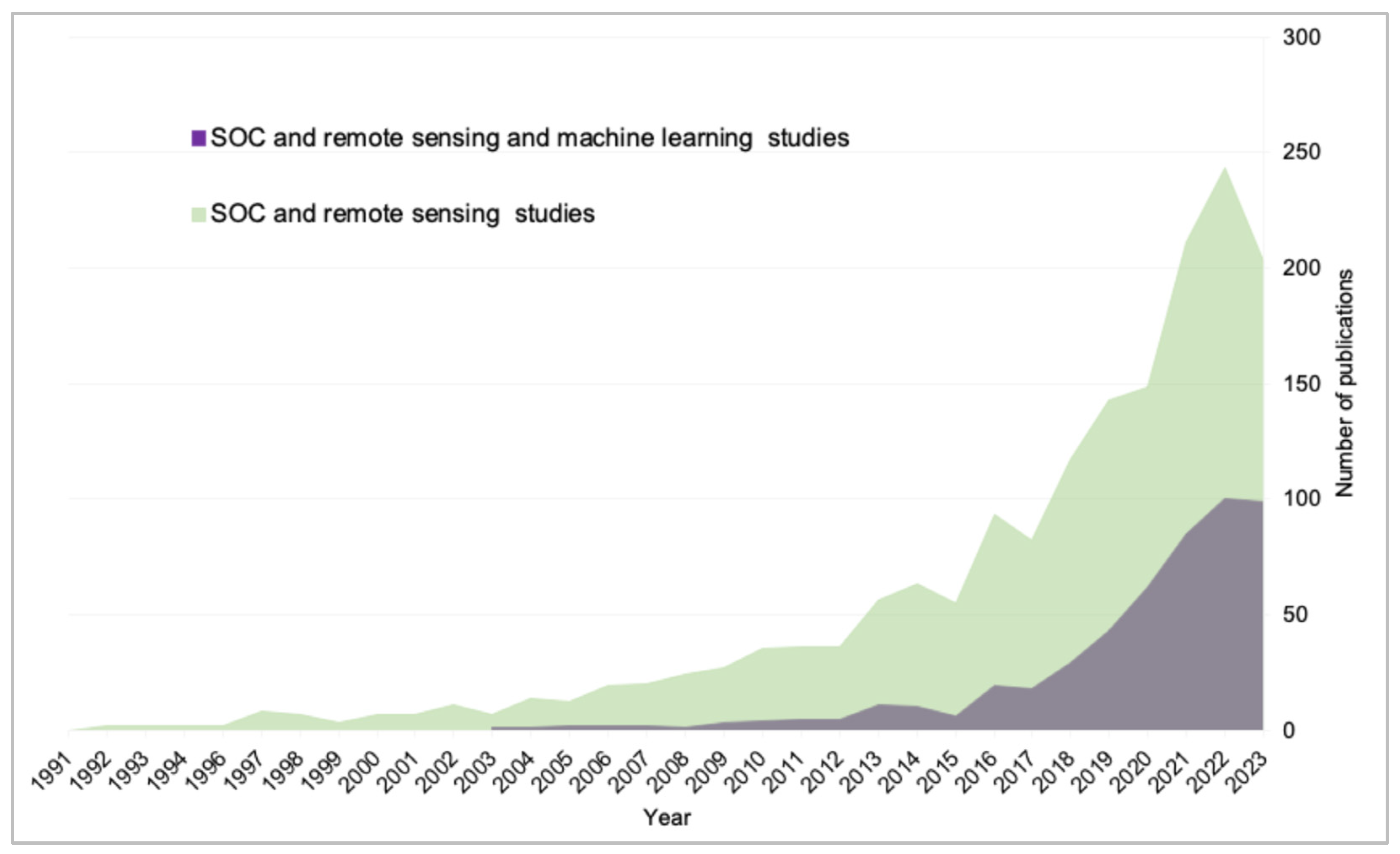
3.1. Basic Publication Statistics

The analysis of general publications reveals several trends in the field of SOC research. Overall, there has been a consistent increase in the number of SOC studies in recent years. Specifically, the number of evaluations with SOC and RS has steadily risen since 1991, reaching a culmination of 203 studies in 2023, indicating the maturation and widespread adoption of RS technology for SOC monitoring and analysis. In contrast, studies on SOC and ML have experienced a rapid surge, with 285 studies in 2023, highlighting the significance of ML techniques in advancing SOC research. Research on SOC through the integration of RS and ML, while showing promise, remains relatively limited, with an increase of 99 studies in 2023. Despite the incompleteness of the 2023 literature search, the results signify the potential integration of RS and ML into SOC research. This integration opens new avenues for a more profound understanding of SOC and its various dynamics (Figure 1).

3.2. Research Trends and Landscape of SOC Estimation Using RS Techniques

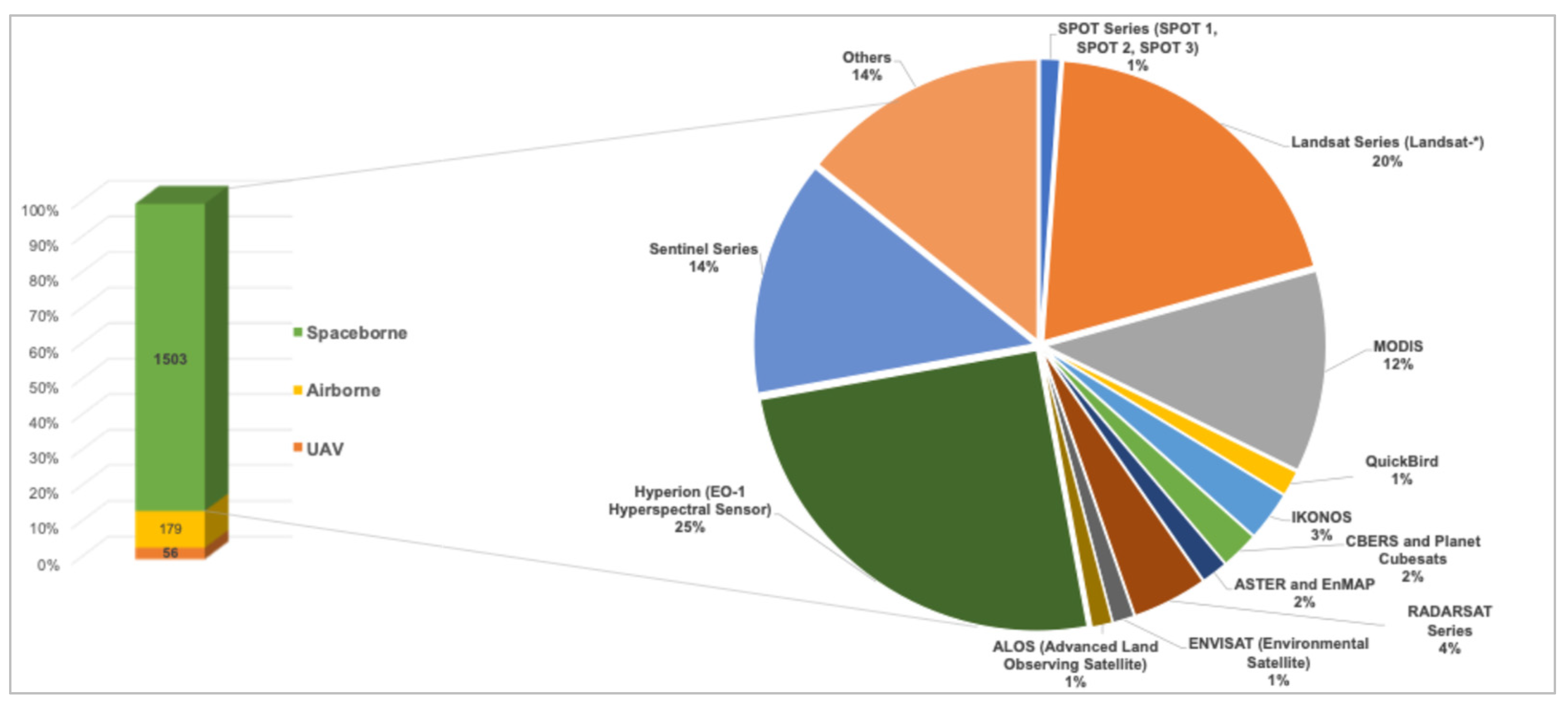
3.2.1. The Utilization Frequency of Different RS Platforms

In SOC estimation, RS platforms demonstrate wide applications for extraction-related data, leveraging technologies such as drones and other unmanned vehicles, aircraft, and satellite-based systems. Airborne RS methods were applied in 179 studies, whereas drone RS was referenced in 56 studies, indicating its relatively limited usage in SOC studies (Figure 2). The statistical results on the usage of satellite RS platforms indicate that the Hyperion (EO-1 Hyperspectral Sensor) is the most widely used platform, appearing in 377 studies, which accounts for 25.08% of the total. This is followed by the Landsat Series (Landsat-*), used in 294 studies (19.56%), and the Sentinel Series, referenced in 204 studies (13.57%). MODIS was utilized in 174 studies (11.58%). Among other platforms, the RADARSAT Series appeared in 65 studies (4.32%), IKONOS in 43 studies (2.86%), and CBERS and Planet Cubesats in 33 studies (2.20%). ASTER and EnMAP were cited in 23 studies (1.53%), QuickBird in 22 studies (1.46%), ENVISAT in 19 studies (1.26%), ALOS in 18 studies (1.20%), and the SPOT Series (SPOT 1, SPOT 2, SPOT 3) in 17 studies (1.13%). Notably, there were 214 studies that remained uncategorized, representing 14.24% of the total (Figure 2).

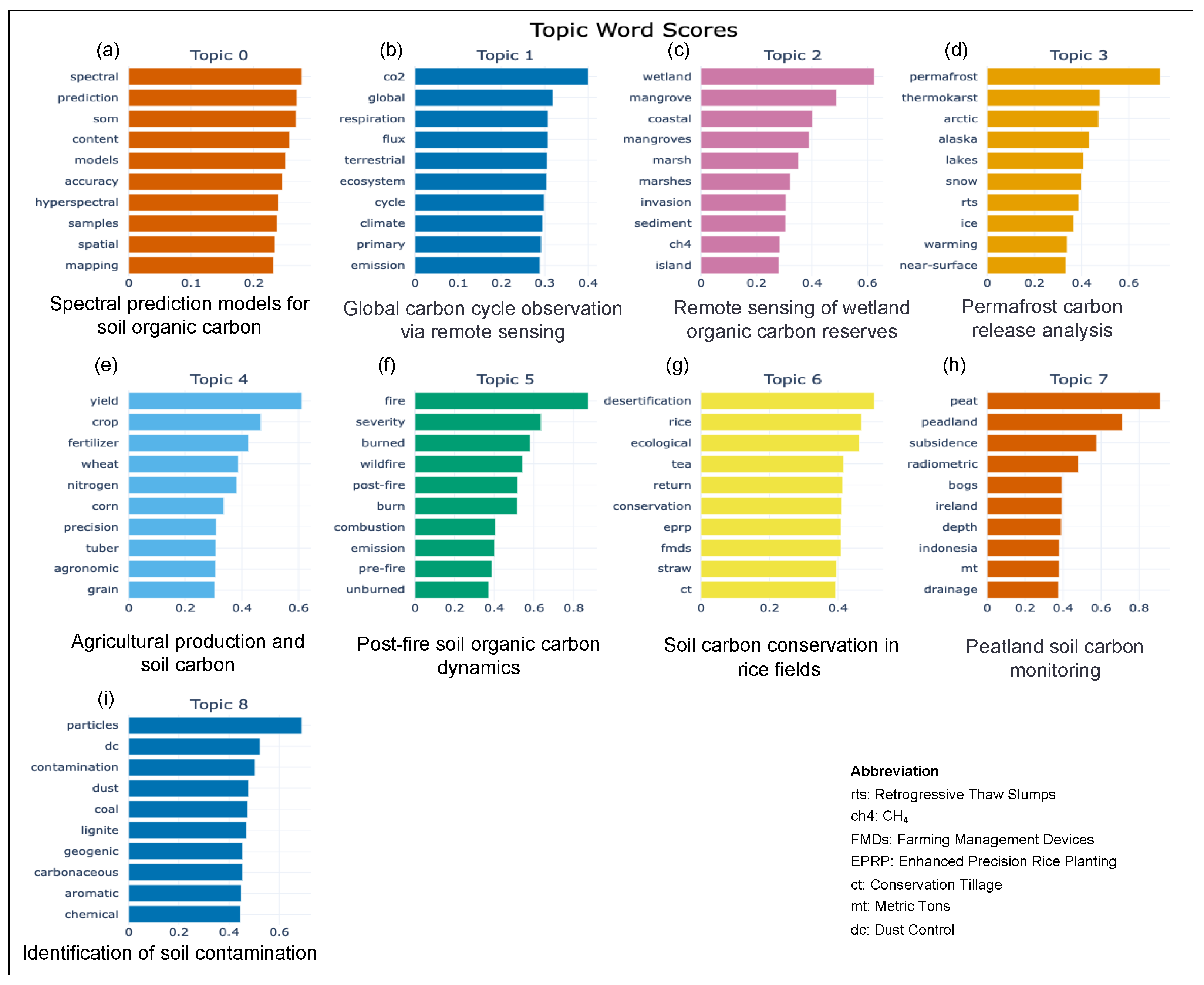
3.2.2. BERTopic Modeling Analysis for Studies of SOC Estimation Using RS

Through BERTopic analysis, the SOC and RS research corpus revealed nine thematic clusters. Topic 0 encapsulates study leverage spectral models and hyperspectral imagery for SOC estimation, reflecting advancements in spatial mapping technologies. In Topic 1, there is a concentration of research on the carbon cycle within terrestrial ecosystems, specifically focusing on carbon dioxide fluxes and respiration processes. Topic 2 highlights wetland SOC dynamics, including methane emissions and the impact of invasive species on sediment, emphasizing the ecological significance of wetlands in the carbon cycle. In Topic 3, the focus is on the impact of climate change on permafrost and thermokarst lakes, with a particular emphasis on SOC stability and climate feedback loops. Topic 4 investigates the influence of agricultural practices on SOC sequestration, investigating the roles of crop management, fertilizer application, and precision farming techniques. Research on the impact of wildfire severity on SOC content is covered in Topic 5, signifying a specialized interest in the interplay between fire events and SOC dynamics. Topic 6 centers on soil conservation within rice cultivation systems, encompassing straw management and conservation tillage techniques. In Topic 7, studies elaborate on peatland SOC, employing radiometric dating to understand SOC accumulation patterns. Lastly, Topic 8 identifies research on the contamination of SOC by particulate matter from both natural and human-induced sources. Each identified topic represents a distinct focus within the SOC and RS domain, highlighting the variety of research interests and methodologies utilized in this scientific field (Figure 3).
The analysis generated a similarity matrix illustrating similarity scores between topics identified by BERTopic modeling within the SOC and RS study corpus. Scores range from 0.5, indicating lower similarity, to 1.0, denoting high similarity or near-identical topics. The color gradation from light to dark blue corresponds to increasing similarity scores. Specifically, the matrix reveals a moderate similarity between Topic 0 (spectral prediction models for soil organic carbon) and Topic 1 (global carbon cycle observation via RS). In contrast, Topic 2 (RS of wetland organic carbon reserves) distinctly differs from Topic 4 (agricultural production and soil carbon) (Figure 3). Furthermore, a higher degree of similarity is observed between Topic 5 (post-fire soil organic carbon dynamics) and Topic 6 (soil carbon conservation in rice fields). Conversely, Topic 7 (peatland soil carbon monitoring) and Topic 8 (identification of soil contamination) exhibit lower similarity scores when compared to the rest of the topics (Figure 4).

3.3. Research Landscape of SOC Estimation via RS and ML Techniques

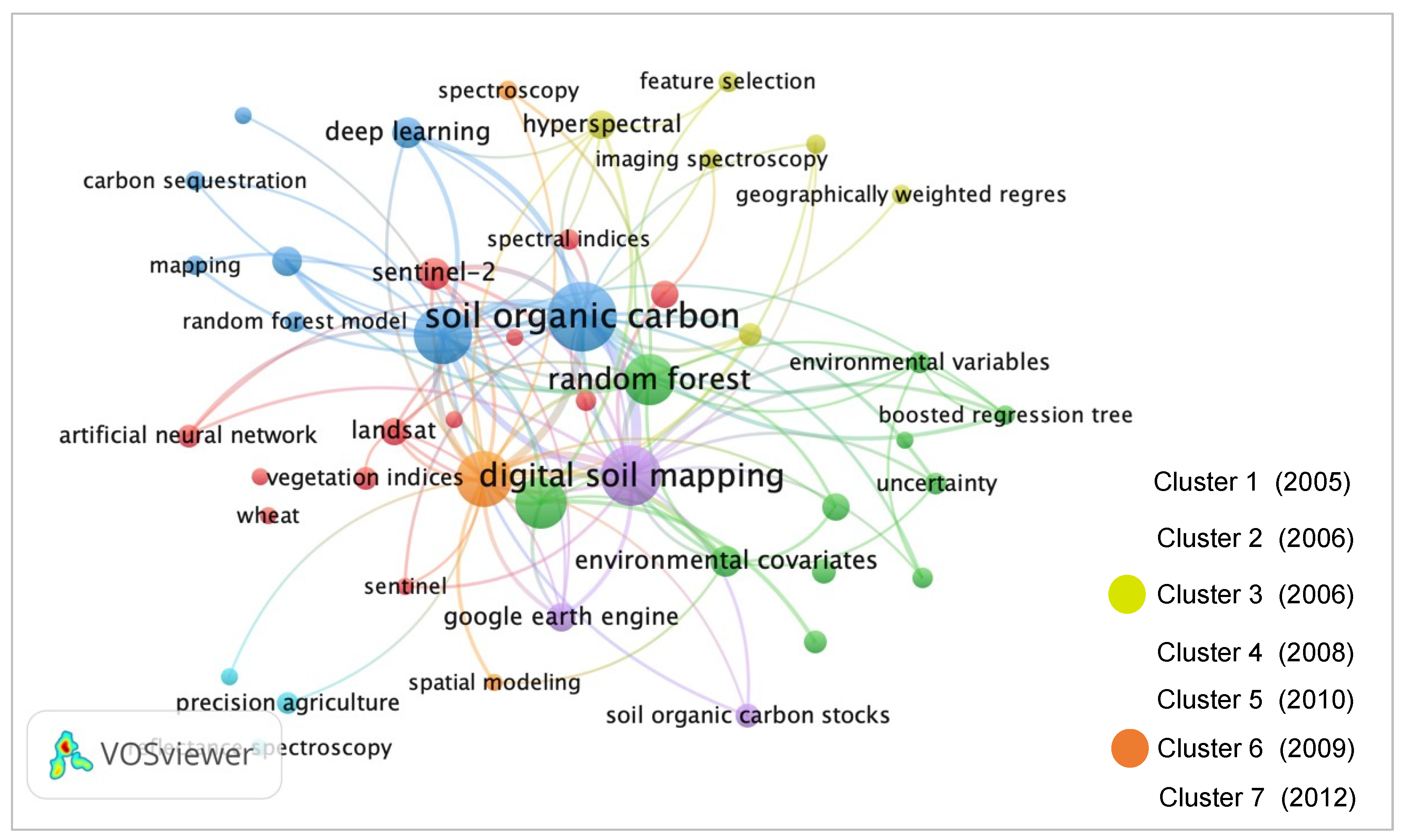
3.3.1. Author Keyword Co-Occurrence Analysis

Keyword co-occurrence analysis produces seven thematic clusters. The first cluster demonstrates the relationship between soil carbon and climate change, utilizing RS techniques with keywords like “carbon sequestration” and “climate change”, emphasizing soil’s crucial role in climate dynamics. The second cluster explores RS technology in land use, featuring advanced monitoring technologies such as “artificial neural network” and “Landsat”. The third cluster focuses on soil properties and spectral techniques, analyzing soil composition through keywords like “hyperspectral” and “imaging spectroscopy”. The fourth cluster emphasizes data analysis and the scrutiny of environmental variables, incorporating terms like “hyperspectral remote sensing” and “random forest”, indicating a focus on data-driven environmental research. The fifth cluster centers on digital soil mapping and geospatial information, highlighting the use of “digital soil mapping” and “Google Earth Engine” for detailed soil mapping. The sixth cluster characterizes the application of spectral techniques and data analysis in soil research, with “spectroscopy” and “spatial modeling” denoting a reliance on spectral data. Lastly, the seventh cluster focuses on precision agriculture, underlining the importance of technology in enhancing agricultural productivity and sustainability through keywords like “precision agriculture” and “reflectance spectroscopy”. These clusters create a cohesive framework of research themes, detailed in the following sections, illustrating the complex interactions between soil science and RS applications (Figure 5).

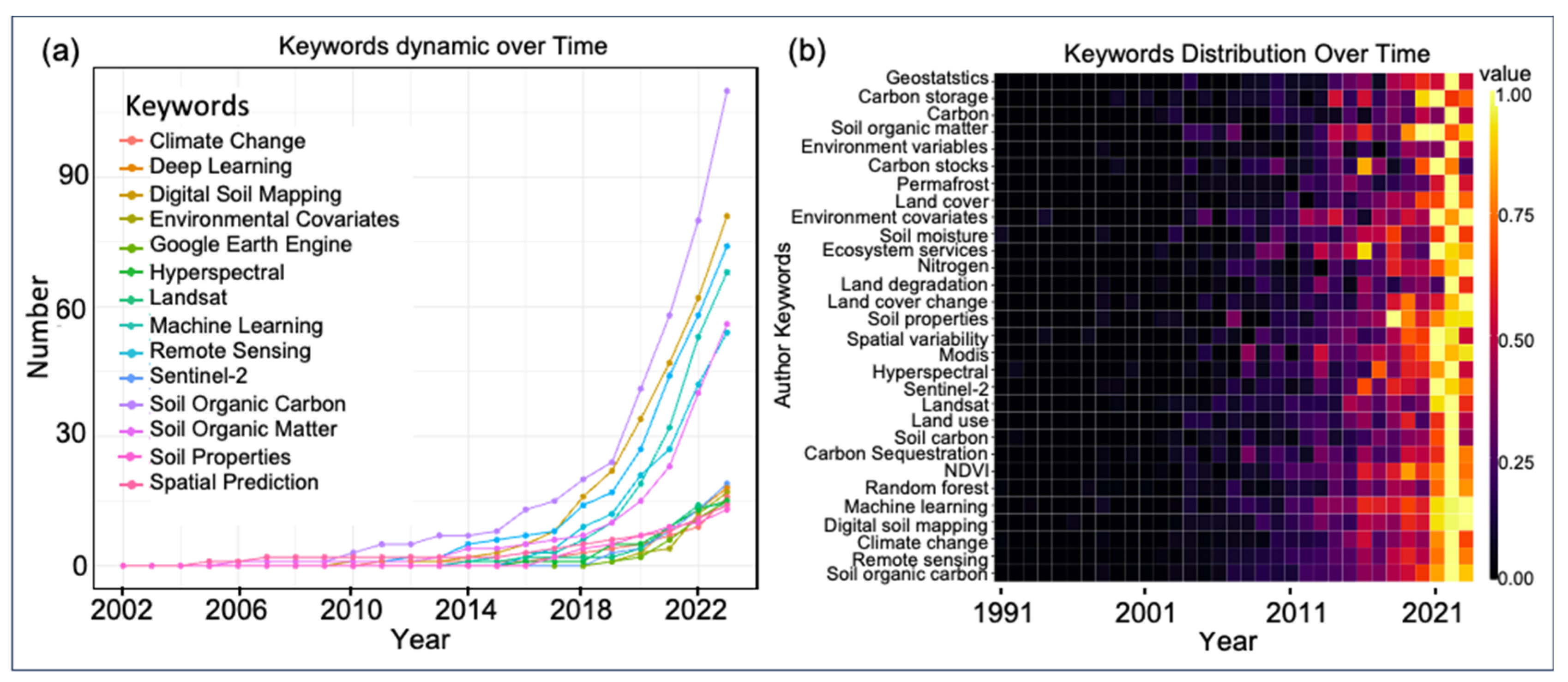
3.3.2. Dynamics and Characterization of Author Keywords and Keywords Plus over Time

The dynamic evolution of soil science research is evident in the shifting patterns of keywords over time (Figure 6a). The keyword “soil organic carbon” has exhibited a notable increase in publications, from only 1 article in 2006 to 110 articles in 2023. This trend surpasses a mere reflection of the overall growth in soil science publications: the study of “digital soil mapping” gained momentum after 2014, reaching 81 articles in 2023, indicating a notable increase in research focus on digital soil mapping and related topics. “Remote sensing” is another keyword that has garnered attention, showing a steady rise since 2006 and culminating in 74 articles by 2023. Moreover, the integration of advanced technologies like “machine learning” and “deep learning” into soil science research, evidenced by the increasing number of articles, showcases the field’s adaptation to cutting-edge methods with which to address complex issues more effectively. Keywords like “random forest”, “Sentinel-2”, and “hyperspectral” further underscore the varied technological approaches enhancing contemporary soil science research (Figure 6a).
The temporal distribution of keywords presented in the heat map provides a comprehensive visualization of the trends in and significance of research keywords in the field of environmental science and RS from 1991 to 2023. Each row corresponds to a specific keyword, while columns represent different years, with color intensity indicating the frequency of research presence, ranging from colorless (0.00) to bright yellow (1.00). After 2012, the map reveals a notable surge in research density associated with keywords like “machine learning”, “remote sensing”, “climate change”, and “carbon sequestration”, signaling a rise in research interest in and academic focus on these areas. Concurrently, keywords like “geostatistics” maintain a consistent presence throughout the timeline, highlighting their sustained relevance in the field. This heat map serves as a valuable tool for comprehending the evolution of research hotspots in environmental science and RS, providing insights into areas where research resources and attention have been concentrated (Figure 6b).

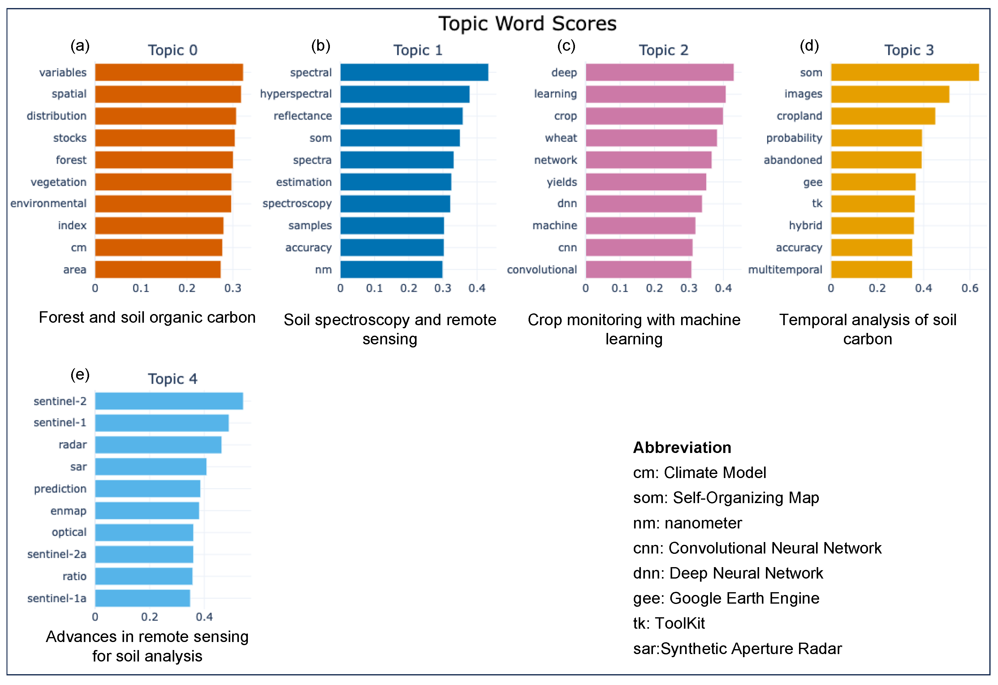
3.3.3. BERTopic Modeling

The BERTopic model applied to SOC prediction studies involving RS and ML has distinguished five primary topics. Topic 0 addresses spatial analysis in forestry for SOC stock assessment, employing variables such as forest density and area measurements. Topic 1 explores soil analysis using spectral data, emphasizing the significance of hyperspectral imaging for precise SOC quantification. In Topic 2, the focus shifts to the integration of deep learning with agricultural datasets, highlighting the role of advanced ML in understanding crop-related SOC dynamics. Topic 3 underscores the use of multitemporal imaging for tracking temporal variations in SOC, indicating a trend towards longitudinal studies on cropland management. Lastly, Topic 4 emphasizes the adoption of advanced RS platforms like Sentinel-2 and SAR for enhanced SOC prediction, demonstrating the field’s progression towards sophisticated observational technologies (Figure 7).

4. Discussion

4.1. BERTopic Modeling Clusters for SOC with RS Techniques

The BERTopic analysis unveils a diverse array of themes within SOC and RS research, reflecting increasing global concerns about environmental issues such as climate change and sustainable land management. The interdisciplinary nature of organic carbon research is evident, driven by technological advances. In the following discussion, we explore the implications, interlinkages, and potential trajectories of these topic clusters, examining how technological advances, environmental concerns, interdisciplinary approaches, and policy directions collectively shape the evolving research landscape. Interpreting the results allows us to gain a clearer understanding of the complex interactions and emerging trends in SOC research.
Topic 0: Spectral Prediction Models for Soil Organic Carbon (195 Papers)
The introduction of hyperspectral imaging has significantly advanced SOC estimation, offering unprecedented spatial mapping detail [44] by capturing hundreds of narrow spectral bands. This enables a deeper understanding of the soil properties influencing SOC [45]; however, the calibration of these models across diverse soil types and landscapes remains a critical research area. While considerable progress has been achieved in calibrating hyperspectral models in controlled environments and specific regions, extending these calibrations to a wide range of soil types and diverse geographic landscapes poses a challenge [15]. The calibration process often necessitates extensive field data collection as well as validation to ensure accuracy across different soil conditions. It is intriguing to note the phenomenon where related keywords exhibit similar scores in this topic. It is imperative to consider variability in soil properties influenced by factors like moisture content, organic matter composition, and mineralogy, which could impact spectral readings/data.
Topic 1: Global Carbon Cycle Observation via RS (289 Papers)
RS plays an important role in monitoring carbon cycles in terrestrial ecosystems, particularly CO2 fluxes and respiration processes, providing a holistic [23,46] view of the carbon cycle through integration with in situ measurements [47]. CO2 scores the most, nearly 0.4, and flux and respiration score 0.3; however, the challenge lies in capturing the fine-scale processes that drive these cycles [48]. Emerging research should focus on utilizing multispectral and hyperspectral imagery to detect subtle changes in vegetation and soil that influence the carbon cycle.
Topic 2: RS of Wetland Organic Carbon Reserves (156 Articles)
Wetlands play a critical role in the global carbon cycle [49,50]. Despite the importance of wetlands, the actual research focuses on coastal areas. This is very interesting and desirable thinking in Topic 2. Additionally, Topic 2 also has an emphasis on methane emissions and the impacts of invasive species, underscoring the significance of wetlands in this context [51]. Considering the roles of carbon sinks and sources of wetlands in relation to invasive species [52], the use of RS to monitor methane emissions and the impact of invasive species on SOC in wetlands presents a novel approach to conserving these ecosystems. The challenge lies in distinguishing between natural and anthropogenic impacts on wetland SOC dynamics. Future studies should leverage the spectral sensitivity of RS to detect changes in wetland composition and functioning [53,54].
Topic 3: Permafrost Carbon Release Analysis (151 Papers)
The impact of climate change on permafrost and thermokarst lakes is a crucial area of study, particularly concerning SOC stability [55,56], often in inaccessible areas. We found that no carbon-related keywords appeared in the keyword analysis, which may be related to the fact that permafrost is an important carbon sink and source. Additionally, the potential for large-scale climate feedback loops [57], as permafrost degradation accelerates, presents a critical focus for ongoing research. RS technologies like synthetic aperture radar (SAR) and light detection and ranging (LIDAR) are instrumental in these environments, providing data on topographical changes and subsurface characteristics. However, interpreting these data in the context of SOC stability requires a multidisciplinary approach, combining RS with climatological, soil, and geological studies.
Topic 4: Agricultural Production and Soil Carbon (187 Papers)
This topic offers an optimistic view of how human intervention in agricultural practices could impact SOC sequestration, especially through crop management [58], fertilizer application, and precision farming, to enhance SOC stocks [59]. The influence of agricultural practices on SOC sequestration is immense [60]. RS could play a significant role in monitoring and improving these practices by utilizing the response of these practices [22]. Precision agriculture, facilitated by RS, allows for tailored soil management that optimizes SOC sequestration [61]. Future research should focus on developing algorithms that accurately assess soil health from RS data, aiding in decision making for sustainable agricultural practices and the Sustainable Development Goals.
Topic 5: Post-Fire Soil Organic Carbon Dynamics (151 Papers)
The complex relationship between wildfire events and SOC dynamics, as demonstrated in Topic 5, is particularly pertinent in the context of climate change [62,63]. Wildfires substantially alter SOC content, highlighting the importance of understanding this interplay [64]. RS offers a means with which to assess the severity and extent of wildfires and their impact on SOC [65]. The challenge lies in developing models capable of predicting the long-term effects of fire events on SOC dynamics [66]. This requires a combination of RS data with expertise in fire ecology and soil science to enhance our understanding of SOC research.
Topic 6: Soil Carbon Conservation in Rice Fields (147 Papers)
Practices for soil conservation within rice cultivation systems, including straw management and conservation tillage, play a crucial role in maintaining SOC [67]. In this cluster, “desertification” stands out as the top keyword for the rice field research. Desertification emerges as a top keyword in this topic about rice fields, primarily due to the intensive water usage and land management practices in rice cultivation, which could contribute to soil degradation and desert-like conditions. The phenomenon is especially pronounced in regions with limited water resources, underscoring the significant environmental impact of agricultural practices on land sustainability. In rice cultivation, soil conservation techniques are vital for maintaining SOC levels [68]. RS could monitor the effectiveness of these practices, offering insights into their impact on SOC [60]. Research should emphasize the potential of RS to guide and validate conservation practices, like straw management and conservation tillage [60], and crop rotations, contributing to sustainable climate-smart agriculture and indirectly advancing SOC research.
Topic 7: Peatland Soil Carbon Monitoring (130 Papers)
Peatlands serve as significant carbon reservoirs, and Topic 7’s emphasis on radiometric dating underscores the importance of a long-term perspective in comprehending SOC accumulation [69,70]. The data indicate that peat research focuses mainly on Ireland and Indonesia. The combination of RS with radiometric dating provides insights into historical SOC accumulation patterns in peatlands [71]. The challenge lies in integrating these historical data with current RS observations to predict future trends in peatland SOC accumulation and loss [72].
Topic 8: Identification of Soil Contamination (93 Papers)
The contamination of SOC by particulate matter is a growing environmental concern [73]. RS has the potential to identify areas where SOC is at risk of contamination, providing essential data for environmental policy and remediation efforts [74]. Research should focus on developing methodologies that combine RS with ground-based sampling to offer a comprehensive view of particulate matter’s impact on SOC [75,76].
Overall, the above nine topics revealed by the BERTopic analysis underscore the multifaceted nature of SOC research, with RS playing a central role in advancing our understanding of these dynamics. Spectral models, crucial for SOC estimation, leverage hyperspectral imagery for enhanced spatial mapping, pointing to future research focused on refining these models under varied soil conditions and integrating them with broader RS data. Emphasizing the carbon cycle, particularly carbon dioxide fluxes and respiration, places SOC studies in a broader environmental context. This highlights the need to explore how SOC dynamics interact with terrestrial ecosystems, especially under climate change.

4.2. Relationship between SOC Estimation and ML and RS Techniques

4.2.1. Keyword Clustering and Dynamics in SOC Research

The keyword co-occurrence analysis unveils distinct thematic clusters, portraying the intricate nature of SOC research. The emergence of clusters exploring the interactions between soil carbon and climate change, the application of RS technology in land use, and the exploration of soil property spectral techniques highlights the diverse and dynamic nature of SOC research interests. The evolving focus areas, transitioning from foundational RS and digital soil mapping to more nuanced topics like carbon sequestration, SOC stocks, and the integration of big data in soil research, indicate the progressive trajectory of the field [14]. In recent years, a noticeable increase in articles addressing advanced modeling techniques, such as ML and deep learning, reflects the intersection of technological advancement with environmental research [77,78]. This dynamic keyword landscape unveils an evolving field that is rapidly adapting to incorporate new methodologies and technologies, contributing to a more profound understanding and effective management of soil resources.

4.2.2. In-Depth Analysis of BERTopic Modeling Clusters

The implementation of the BERTopic model in SOC prediction studies has delineated five distinct and unique topics, elucidating the utilization of RS and ML in comprehending and forecasting SOC. In the following subsections, each of these topics is addressed in detail, examining their implications, current advancements, and future directions.
Topic 0: Forestry and Spatial Analysis (124 Papers)
In Topic 0, the exploration of spatial analysis within forestry for SOC stock assessment unveils a complex interplay between forest structural characteristics and carbon storage functionality. The use of forest density and area measurements as indicators for biomass reflects a detailed strategy for estimating SOC stocks [79]; however, the spatial heterogeneity inherent in forest ecosystems provides significant challenges. Variations in forest management practices, disturbance regimes, and ecological succession could compromise the accuracy of SOC predictions. Future research should concentrate on refining spatial analysis methodologies and incorporating more detailed data to capture these ecological complexities.
Topic 1: Soil Spectroscopy and RS (87 Papers)
Topic 1 focuses on hyperspectral imaging for detecting subtle differences in soil properties influencing SOC levels. SOC stocks are a frequent keyword from the score, and more environmental factors need to be considered; however, it is crucial to acknowledge the limitations imposed by the high dimensionality of hyperspectral data, which necessitates sophisticated data reduction and feature selection techniques. ML algorithms, particularly those based on spectral unmixing and feature extraction, are well suited to address these challenges [80,81]. Looking ahead, advancements in ML could further enhance the ability to clarify relevant information from hyperspectral data, facilitating more accurate SOC quantification.
Topic 2: Crop Monitoring with ML (92 Papers)
The integration of deep learning with agricultural datasets, as highlighted in Topic 2, represents a frontier in prediction SOC dynamics. Deep learning algorithms, such as convolutional neural networks (CNNs) and recurrent neural networks (RNNs), show promise in capturing the complex relationships between agricultural practices and SOC changes; however, these models require extensive datasets for training to avoid overfitting and ensure generalizability to new, unseen data [82,83]. The scarcity of such datasets in certain regions and the need for data spanning significant temporal scales pose ongoing challenges. Future efforts may focus on developing transfer learning approaches that utilize pretrained models on extensive datasets, thereby mitigating data limitations and enhancing model robustness.
Topic 3: Temporal Analysis of Soil Carbon(95 Papers)
Topic 3 suggests the significance of multitemporal imaging in discerning temporal variations in SOC. Here, SOM is a self-organizing map rather than soil organic matter, and has the highest score, indicating that ML techniques provide an important function of monitoring [84,85]. Monitoring SOC changes over time is crucial for comprehending the enduring impact of land-use change, agricultural practices, and climate change on carbon sequestration [1,52]. It is important to critically evaluate the required temporal resolution to effectively capture SOC dynamics and explore the potential of emerging satellite technologies in addressing current gaps in data continuity.
Topic 4: Advancesfor RS is Soil Analysis (92 Papers)
The progression towards diverse RS technologies, as highlighted in Topic 4, enables precise SOC prediction. The deployment of platforms like Sentinel-2 and SAR has opened a new way for high-resolution, all-weather monitoring of SOC [86]. The integration of these technologies with ML models has proven particularly effective in processing the substantial volumes of data generated by these platforms. Additionally, addressing the challenges associated with synthesizing multisource RS data, which vary in spatial, temporal, and spectral resolutions, warrants careful consideration.

4.3. Challenges in the Integration of RS and ML Techniques for SOC Estimation

In studies that leverage RS and ML for estimating SOC, several limitations warrant careful consideration. A primary constraint is the quality and availability of data, with the resolution of remotely sensed imagery—both spatial and spectral—playing a pivotal role in the accuracy of SOC predictions. Low-resolution images may fail to capture the nuanced heterogeneity of soils, leading to less precise SOC estimates [87,88]. Moreover, the need for continuous, high-quality time series data with which to monitor SOC fluctuations over time presents a challenge that is not always surmountable for every region of interest [89,90]. Secondly, the promise of ML models in SOC prediction within RS data is tempered by intrinsic uncertainties [14]. These can emanate from various sources, including the model’s structure, its parameterization, and the representativeness of the training dataset. Extending these models beyond the scope of their training datasets can exacerbate these uncertainties, potentially undermining the reliability of SOC estimations. Furthermore, the multifaceted influences on SOC—ranging from climatic conditions and land use to vegetation cover and soil properties—present an obstacle to grasping the detailed dynamics between these factors through RS and ML. The diversity in carbon dynamics across different ecosystems and soil types can restrict the applicability of developed models, confining their utility to specific regions or conditions [91,92]. Additionally, the slow pace of SOC changes, possibly influenced by historical land-use and management practices, may not be immediately apparent in RS data [93]. This temporal lag between cause and effect introduces further complexity in accurately assessing SOC stocks and changes, as RS typically offers only a temporal snapshot.
While RS and ML methodologies have demonstrated potential in localized studies, scaling these models for global SOC assessments presents substantial challenges [14]. The heterogeneity in soil types, vegetation, climate, and land management practices worldwide complicates the task of generalizing models developed in localized settings, necessitating either the creation of region-specific models or the adaptation of existing ones to diverse conditions [94]. Lastly, the processing of vast RS datasets and the training of complex ML models demand considerable computational resources [15]. The availability of these resources, along with the requisite technical expertise for deploying and interpreting RS and ML approaches, can be a significant barrier, particularly in resource-constrained settings.

4.4. Limitations

In defining our search strategy for “remote sensing” in this study, we utilized keywords that spanned satellite RS, aerial RS, unmanned aerial vehicle (UAV) RS, and other related technologies. While our strategy did not explicitly include the term “infrared remote sensing”, it incorporated the use of several platforms equipped with infrared sensors capable of capturing infrared light across different wavelengths. Particularly noteworthy among these platforms are the Landsat series, Moderate Resolution Imaging Spectroradiometer (MODIS), and Sentinel-2, all of which employ infrared technology. “Infrared” as a standalone keyword was excluded, as it may have overexpanded the scope of the literature to include a large number of studies focusing on near-end RS techniques such as NIR (near-infrared), MIR (mid-infrared), and VIR (visible and infrared). These techniques are often used in contexts that are not directly aligned with our primary research goal of estimating SOC through RS technologies.
Moreover, this approach also presents several limitations. Firstly, by not explicitly including all infrared-related terms, there may be relevant studies that employ infrared RS techniques for SOC estimation that were unintentionally excluded from our analysis. Secondly, our focus on specific RS platforms may have led to an underrepresentation of emerging or less commonly used technologies that could contribute valuable insights into SOC estimation. Thirdly, while we aimed to capture a comprehensive overview of RS applications for SOC, the exclusion of non-RS approaches (e.g., ground-based or proximal sensing methods) limits the scope of our review to airborne and spaceborne techniques, potentially overlooking integrative approaches that combine multiple sensing modalities.
Additionally, our bibliometric analysis is inherently limited by the quality and comprehensiveness of the databases used for literature retrieval. Any biases or omissions in the databases may have influenced the selection of studies included in our review. Furthermore, the reliance on Keywords Plus and Author Keywords may have introduced variability in the keyword analysis, as these two approaches capture different aspects of the literature. Finally, while we have strived to provide a balanced and thorough review, the rapidly evolving nature of RS technologies means that new developments may have emerged since the completion of our literature search.

5. Conclusions

Among the 1761 papers focusing on SOC with RS technologies, RS application is predominantly concentrated on monitoring SOC on a spatial scale. While RS technologies provide extensive global coverage and facilitate long-term monitoring, their interpretive power is limited by resolution and spectral range constraints, especially when dealing with microscale SOC variations under complex surface conditions. The incorporation of ML techniques, as seen in 490 papers, has significantly enhanced the precision of SOC estimates, improving RS data processing and interpretation for high-dimensional datasets. Keyword analysis indicates that studies using RS alone often focus on environmental monitoring, highlighting terms like “soil moisture” and “vegetation index”, reflecting RS’s application in environmental monitoring. In contrast, themes emerging from studies integrating ML with RS include “algorithm optimization” and “data mining”, reflecting a focus on complex data analysis and the ability to address intricate environmental feedback mechanisms. BERTopic modeling identified key research topics, providing a comprehensive view of current SOC estimation research and suggesting future directions.
In conclusion, the integration of BERTopic modeling and bibliometric analysis in this review marks a novel approach to dissecting the field of SOC estimation using RS and ML. The review identifies key thematic clusters, reflects the diverse and complex nature of SOC research, and highlights the evolving application of spectral analysis and data-driven models. Moreover, it draws attention to the challenges and potential avenues for future research, advocating for greater data precision, algorithmic advancement, and interdisciplinary collaboration. This comprehensive understanding not only highlights the important role of SOC in environmental and agricultural contexts but also sets the stage for future advancements in sustainable soil management and environmental conservation.

Author Contributions

Conceptualization, T.L., Y.P.D., R.C.D. and T.I.M.; literature collection, T.L., H.L., A.X. and L.C.; funding acquisition, Y.P.D.; methodology, T.L., Y.W. and Y.P.D.; resources, Y.P.D.; software, T.L., L.C. and Y.W.; supervision, Y.P.D.; writing—original draft, T.L. and L.C.; writing—review and editing, T.L., L.C., Y.W., T.I.M., A.X., R.P., H.L., W.W., Z.X., X.S., R.C.D. and Y.P.D.; academic editing, Z.X., R.P., T.I.M., R.C.D. and Y.P.D. All authors have read and agreed to the published version of the manuscript.

Funding

This research was funded by the Commonwealth Department of Industry, Science, Energy and Resources, grant SCICDD00002.

Data Availability Statement

The datasets generated and analyzed during the current study are available from the corresponding author upon reasonable request. To advance the scientific use of BERTopic in other fields, we provide a detailed protocol, as follows. Abstracts were collected from the Web of Science database and preprocessed through tokenization, stop-word removal, lemmatization, and n-gram extraction. Text data were then converted into numerical embeddings using the “all-MiniLM-L6-v2” sentence transformer model, followed by dimensionality reduction with UMAP to preserve semantic structure. Clustering was performed using HDBSCAN, which effectively identified distinct topics while managing outliers. Keywords for each topic were selected using the c-TF–IDF method, balancing word frequency with contextual significance. The coherence and relevance of topics were validated through expert review, ensuring that they accurately represented key themes in the literature. This protocol provides a step-by-step guide for implementing BERTopic, offering a robust framework for thematic analysis in various research fields.

Conflicts of Interest

The authors declare no conflicts of interest.

References

  1. Sommer, R.; Bossio, D. Dynamics and climate change mitigation potential of soil organic carbon sequestration. J. Environ. Manag. 2014, 144, 83–87. [Google Scholar] [CrossRef] [PubMed]
  2. Lal, R. Digging deeper: A holistic perspective of factors affecting soil organic carbon sequestration in agroecosystems. Glob. Chang. Biol. 2018, 24, 3285–3301. [Google Scholar] [CrossRef]
  3. Hernandez-Morcillo, M.; Burgess, P.; Mirck, J.; Pantera, A.; Plieninger, T. Scanning agroforestry-based solutions for climate change mitigation and adaptation in Europe. Environ. Sci. Policy 2018, 80, 44–52. [Google Scholar] [CrossRef]
  4. Minasny, B.; Malone, B.P.; McBratney, A.B.; Angers, D.A.; Arrouays, D.; Chambers, A.; Chaplot, V.; Chen, Z.-S.; Cheng, K.; Das, B.S.; et al. Soil carbon 4 per mille. Geoderma 2017, 292, 59–86. [Google Scholar] [CrossRef]
  5. Scialabba, N.E.H.; Muller-Lindenlauf, M. Organic agriculture and climate change. Renew. Agric. Food Syst. 2010, 25, 158–169. [Google Scholar] [CrossRef]
  6. Dong, S.K.; Shang, Z.H.; Gao, J.X.; Boone, R.B. Enhancing sustainability of grassland ecosystems through ecological restoration and grazing management in an era of climate change on Qinghai-Tibetan Plateau. Agric. Ecosyst. Environ. 2020, 287, 106684. [Google Scholar] [CrossRef]
  7. Jiang, C.; Zhang, L. Ecosystem change assessment in the Three-river Headwater Region, China: Patterns, causes, and implications. Ecol. Eng. 2016, 93, 24–36. [Google Scholar] [CrossRef]
  8. Burle, M.L.; Mielniczuk, J.; Focchi, S. Effect of cropping systems on soil chemical characteristics, with emphasis on soil acidification. Plant Soil 1997, 190, 309–316. [Google Scholar] [CrossRef]
  9. Bandara, T.; Franks, A.; Xu, J.; Bolan, N.; Wang, H.; Tang, C. Chemical and biological immobilization mechanisms of potentially toxic elements in biochar-amended soils. Crit. Rev. Environ. Sci. Technol. 2020, 50, 903–978. [Google Scholar] [CrossRef]
  10. Xu, Z.; Tsang, D.C. Redox-induced transformation of potentially toxic elements with organic carbon in soil. Carbon Res. 2022, 1, 9. [Google Scholar] [CrossRef]
  11. Zhu, X.B.; He, H.L.; Ma, M.G.; Ren, X.L.; Zhang, L.; Zhang, F.W.; Li, Y.N.; Shi, P.L.; Chen, S.P.; Wang, Y.F.; et al. Estimating Ecosystem Respiration in the Grasslands of Northern China Using Machine Learning: Model Evaluation and Comparison. Sustainability 2020, 12, 2099. [Google Scholar] [CrossRef]
  12. Wang, S.; Guan, K.; Zhang, C.; Lee, D.; Margenot, A.J.; Ge, Y.; Peng, J.; Zhou, W.; Zhou, Q.; Huang, Y. Using soil library hyperspectral reflectance and machine learning to predict soil organic carbon: Assessing potential of airborne and spaceborne optical soil sensing. Remote Sens. Environ. 2022, 271, 112914. [Google Scholar] [CrossRef]
  13. Zhou, Y.; Zhao, X.; Guo, X.; Li, Y. Mapping of soil organic carbon using machine learning models: Combination of optical and radar remote sensing data. Soil Sci. Soc. Am. J. 2022, 86, 293–310. [Google Scholar] [CrossRef]
  14. Angelopoulou, T.; Tziolas, N.; Balafoutis, A.; Zalidis, G.; Bochtis, D. Remote sensing techniques for soil organic carbon estimation: A review. Remote Sens. 2019, 11, 676. [Google Scholar] [CrossRef]
  15. Li, T.; Xia, A.; McLaren, T.I.; Pandey, R.; Xu, Z.; Liu, H.; Manning, S.; Madgett, O.; Duncan, S.; Rasmussen, P. Preliminary Results in Innovative Solutions for Soil Carbon Estimation: Integrating Remote Sensing, Machine Learning, and Proximal Sensing Spectroscopy. Remote Sens. 2023, 15, 5571. [Google Scholar] [CrossRef]
  16. Silvero, N.E.; Demattê, J.A.; Minasny, B.; Rosin, N.A.; Nascimento, J.G.; Albarracín, H.S.R.; Bellinaso, H.; Gómez, A.M. Sensing technologies for characterizing and monitoring soil functions: A review. Adv. Agron. 2023, 177, 125–168. [Google Scholar]
  17. Thulin, S.; Hill, M.J.; Held, A.; Jones, S.; Woodgate, P. Hyperspectral determination of feed quality constituents in temperate pastures: Effect of processing methods on predictive relationships from partial least squares regression. Int. J. Appl. Earth Obs. Geoinf. 2012, 19, 322–334. [Google Scholar] [CrossRef]
  18. Darvishzadeh, R.; Skidmore, A.; Schlerf, M.; Atzberger, C.; Corsi, F.; Cho, M. LAI and chlorophyll estimation for a heterogeneous grassland using hyperspectral measurements. ISPRS J. Photogramm. Remote Sens. 2008, 63, 409–426. [Google Scholar] [CrossRef]
  19. Kumar, M.; Kumar, A.; Thakur, T.K.; Sahoo, U.K.; Kumar, R.; Konsam, B.; Pandey, R. Soil organic carbon estimation along an altitudinal gradient of chir pine forests in the Garhwal Himalaya, India: A field inventory to remote sensing approach. Land Degrad. Dev. 2022, 33, 3387–3400. [Google Scholar] [CrossRef]
  20. Odebiri, O.; Odindi, J.; Mutanga, O. Basic and deep learning models in remote sensing of soil organic carbon estimation: A brief review. Int. J. Appl. Earth Obs. Geoinf. 2021, 102, 102389. [Google Scholar] [CrossRef]
  21. Angelopoulou, T.; Balafoutis, A.; Zalidis, G.; Bochtis, D. From laboratory to proximal sensing spectroscopy for soil organic carbon estimation—A review. Sustainability 2020, 12, 443. [Google Scholar] [CrossRef]
  22. Yuzugullu, O.; Lorenz, F.; Fröhlich, P.; Liebisch, F. Understanding Fields by Remote Sensing: Soil Zoning and Property Mapping. Remote Sens. 2020, 12, 1116. [Google Scholar] [CrossRef]
  23. Xiao, J.; Chevallier, F.; Gomez, C.; Guanter, L.; Hicke, J.A.; Huete, A.R.; Ichii, K.; Ni, W.; Pang, Y.; Rahman, A.F. Remote sensing of the terrestrial carbon cycle: A review of advances over 50 years. Remote Sens. Environ. 2019, 233, 111383. [Google Scholar] [CrossRef]
  24. Li, T.; Cui, L.; Xu, Z.; Hu, R.; Joshi, P.K.; Song, X.; Tang, L.; Xia, A.; Wang, Y.; Guo, D.; et al. Quantitative analysis of the research trends and areas in grassland remote sensing: A scientometrics analysis of web of science from 1980 to 2020. Remote Sens. 2021, 13, 1279. [Google Scholar] [CrossRef]
  25. Liu, H.; Cui, L.; Li, T.; Schillaci, C.; Song, X.; Pastorino, P.; Zou, H.; Cui, X.; Xu, Z.; Fantke, P. Micro- and Nanoplastics in Soils: Tracing Research Progression from Comprehensive Analysis to Ecotoxicological Effects. Ecol. Indic. 2023, 156, 111109. [Google Scholar] [CrossRef]
  26. Wang, Z.; Chen, J.; Chen, J.; Chen, H. Identifying interdisciplinary topics and their evolution based on BERTopic. Scientometrics 2023, 1–26. [Google Scholar] [CrossRef]
  27. McInnes, L.; Healy, J.; Melville, J. Uniform manifold approximation and projection for dimension reduction. arXiv 2020, arXiv:1802.03426. [Google Scholar]
  28. Wang, B.; Kuo, C.-C.J. Sbert-wk: A sentence embedding method by dissecting bert-based word models. IEEE/ACM Trans. Audio Speech Lang. Process. 2020, 28, 2146–2157. [Google Scholar] [CrossRef]
  29. Grootendorst, M. BERTopic: Neural topic modeling with a class-based TF-IDF procedure. arXiv 2022, arXiv:2203.05794. [Google Scholar]
  30. Axelborn, H.; Berggren, J. Topic Modeling for Customer Insights: A Comparative Analysis of LDA and BERTopic in Categorizing Customer Calls. Master’s Thesis, Umeå University, Umeå, Sweden, 2023. [Google Scholar]
  31. Atzeni, D.; Bacciu, D.; Mazzei, D.; Prencipe, G. A Systematic Review of Wi-Fi and Machine Learning Integration with Topic Modeling Techniques. Sensors 2022, 22, 4925. [Google Scholar] [CrossRef]
  32. Devlin, J.; Chang, M.-W.; Lee, K.; Toutanova, K. Bert: Pre-training of deep bidirectional transformers for language understanding. arXiv 2018, arXiv:1810.04805. [Google Scholar]
  33. Frick, R.A.; Vogel, I. Fraunhofer SIT at CheckThat! 2022: Ensemble similarity estimation for finding previously fact-checked claims. In Proceedings of the CLEF 2022: Conference and Labs of the Evaluation Forum, Bologna, Italy, 5–8 September 2022; Notes of CLEF. pp. 5–8. [Google Scholar]
  34. Yu, C.-W.; Chuang, Y.-S.; Lotsos, A.N.; Haase, C.M. Decoding Affect in Dyadic Conversations: Leveraging Semantic Similarity through Sentence Embedding. arXiv 2023, arXiv:2309.12646. [Google Scholar]
  35. McInnes, L.; Healy, J.; Melville, J. UMAP: Uniform Manifold Approximation and Projection. J. Open Source Softw. 2018, 3, 861. [Google Scholar] [CrossRef]
  36. Aytaç, E.; Khayet, M. A Topic Modeling Approach to Discover the Global and Local Subjects in Membrane Distillation Separation Process. Separations 2023, 10, 482. [Google Scholar] [CrossRef]
  37. Yang, D.; Wei, V.; Jin, Z.; Yang, Z.; Chen, X. A UMAP-based clustering method for multi-scale damage analysis of laminates. Appl. Math. Model. 2022, 111, 78–93. [Google Scholar] [CrossRef]
  38. McInnes, L.; Healy, J.; Astels, S. hdbscan: Hierarchical density based clustering. J. Open Source Softw. 2017, 2, 205. [Google Scholar] [CrossRef]
  39. Bushra, A.A.; Yi, G. Comparative analysis review of pioneering DBSCAN and successive density-based clustering algorithms. IEEE Access 2021, 9, 87918–87935. [Google Scholar] [CrossRef]
  40. Abuzayed, A.; Al-Khalifa, H. BERT for Arabic topic modeling: An experimental study on BERTopic technique. Procedia Comput. Sci. 2021, 189, 191–194. [Google Scholar] [CrossRef]
  41. van Eck, N.J.; Waltman, L. Software survey: VOSviewer, a computer program for bibliometric mapping. Scientometrics 2010, 84, 523–538. [Google Scholar] [CrossRef]
  42. Bin, C.; Weiqi, C.; Shaoling, C.; Chunxia, H. Visual Analysis of Research Hot Spots, Characteristics, and Dynamic Evolution of International Competitive Basketball Based on Knowledge Mapping. SAGE Open 2021, 11, 2158244020988725. [Google Scholar] [CrossRef]
  43. Li, T.; Wang, Y.; Cui, L.; Singh, R.K.; Liu, H.; Song, X.; Xu, Z.; Cui, X. Exploring the evolving landscape of COVID-19 interfaced with livelihoods. Humanit. Soc. Sci. Commun. 2023, 10, 908. [Google Scholar] [CrossRef]
  44. Lu, B.; Dao, P.D.; Liu, J.; He, Y.; Shang, J. Recent advances of hyperspectral imaging technology and applications in agriculture. Remote Sens. 2020, 12, 2659. [Google Scholar] [CrossRef]
  45. Howitt, R.; Karp, L.; Rausser, G. Remote sensing technologies: Implications for agricultural and resource economics. In Modern Agricultural and Resource Economics and Policy: Essays in Honor of Gordon Rausser; Springer: Berlin/Heidelberg, Germany, 2022; pp. 183–217. [Google Scholar]
  46. Malhi, Y.; Girardin, C.; Metcalfe, D.B.; Doughty, C.E.; Aragão, L.E.; Rifai, S.W.; Oliveras, I.; Shenkin, A.; Aguirre-Gutiérrez, J.; Dahlsjö, C.A. The Global Ecosystems Monitoring network: Monitoring ecosystem productivity and carbon cycling across the tropics. Biol. Conserv. 2021, 253, 108889. [Google Scholar] [CrossRef]
  47. Umair, M.; Kim, D.; Ray, R.L.; Choi, M. Evaluation of atmospheric and terrestrial effects in the carbon cycle for forest and grassland ecosystems using a remote sensing and modeling approach. Agric. For. Meteorol. 2020, 295, 108187. [Google Scholar] [CrossRef]
  48. Gentine, P.; Green, J.K.; Guérin, M.; Humphrey, V.; Seneviratne, S.I.; Zhang, Y.; Zhou, S. Coupling between the terrestrial carbon and water cycles—A review. Environ. Res. Lett. 2019, 14, 083003. [Google Scholar] [CrossRef]
  49. Mitra, S.; Wassmann, R.; Vlek, P.L. Global Inventory of Wetlands and Their Role in the Carbon Cycle; ZEF Discussion Papers on Development Policy, No. 64; University of Bonn, Center for Development Research (ZEF): Bonn, Germany, 2003; Available online: https://ageconsearch.umn.edu/record/18771 (accessed on 25 August 2024).
  50. Sjögersten, S.; Black, C.R.; Evers, S.; Hoyos-Santillan, J.; Wright, E.L.; Turner, B.L. Tropical wetlands: A missing link in the global carbon cycle? Glob. Biogeochem. Cycles 2014, 28, 1371–1386. [Google Scholar] [CrossRef]
  51. Poulter, B.; Fluet-Chouinard, E.; Hugelius, G.; Koven, C.; Fatoyinbo, L.; Page, S.E.; Rosentreter, J.A.; Smart, L.S.; Taillie, P.J.; Thomas, N. A review of global wetland carbon stocks and management challenges. Wetl. Carbon Environ. Manag. 2021, 1–20. [Google Scholar]
  52. Were, D.; Kansiime, F.; Fetahi, T.; Cooper, A.; Jjuuko, C. Carbon sequestration by wetlands: A critical review of enhancement measures for climate change mitigation. Earth Syst. Environ. 2019, 3, 327–340. [Google Scholar] [CrossRef]
  53. Thamaga, K.H.; Dube, T.; Shoko, C. Advances in satellite remote sensing of the wetland ecosystems in Sub-Saharan Africa. Geocarto Int. 2022, 37, 5891–5913. [Google Scholar] [CrossRef]
  54. Gxokwe, S.; Dube, T.; Mazvimavi, D. Multispectral remote sensing of wetlands in semi-arid and arid areas: A review on applications, challenges and possible future research directions. Remote Sens. 2020, 12, 4190. [Google Scholar] [CrossRef]
  55. Jakob, M. Landslides in a changing climate. In Landslide Hazards, Risks, and Disasters; Elsevier: Amsterdam, The Netherlands, 2022; pp. 505–579. [Google Scholar]
  56. Stoknes, P.E. What We Think about When We Try Not to Think about Global Warming: Toward a New Psychology of Climate Action; Chelsea Green Publishing: Junction, VT, USA, 2015. [Google Scholar]
  57. Li, Z.; Xu, W.; Kang, L.; Kuzyakov, Y.; Chen, L.; He, M.; Liu, F.; Zhang, D.; Zhou, W.; Liu, X.; et al. Accelerated organic matter decomposition in thermokarst lakes upon carbon and phosphorus inputs. Glob. Chang. Biol. 2023, 29, 6367–6382. [Google Scholar] [CrossRef] [PubMed]
  58. Godde, C.M.; de Boer, I.J.; Ermgassen, E.z.; Herrero, M.; van Middelaar, C.E.; Muller, A.; Röös, E.; Schader, C.; Smith, P.; Van Zanten, H.H. Soil carbon sequestration in grazing systems: Managing expectations. Clim. Chang. 2020, 161, 385–391. [Google Scholar] [CrossRef]
  59. Tantalaki, N.; Souravlas, S.; Roumeliotis, M. Data-driven decision making in precision agriculture: The rise of big data in agricultural systems. J. Agric. Food Inf. 2019, 20, 344–380. [Google Scholar] [CrossRef]
  60. Mandal, A.; Majumder, A.; Dhaliwal, S.; Toor, A.; Mani, P.K.; Naresh, R.; Gupta, R.K.; Mitran, T. Impact of agricultural management practices on soil carbon sequestration and its monitoring through simulation models and remote sensing techniques: A review. Crit. Rev. Environ. Sci. Technol. 2022, 52, 1–49. [Google Scholar] [CrossRef]
  61. Verma, B.; Porwal, M.; Jha, A.; Vyshnavi, R.; Rajpoot, A.; Nagar, A.K. Enhancing Precision Agriculture and Environmental Monitoring Using Proximal Remote Sensing. J. Exp. Agric. Int. 2023, 45, 162–176. [Google Scholar] [CrossRef]
  62. Dieleman, C.M.; Rogers, B.M.; Potter, S.; Veraverbeke, S.; Johnstone, J.F.; Laflamme, J.; Solvik, K.; Walker, X.J.; Mack, M.C.; Turetsky, M.R. Wildfire combustion and carbon stocks in the southern Canadian boreal forest: Implications for a warming world. Glob. Chang. Biol. 2020, 26, 6062–6079. [Google Scholar] [CrossRef]
  63. Gonçalves, D.R.P.; Mishra, U.; Wills, S.; Gautam, S. Regional environmental controllers influence continental scale soil carbon stocks and future carbon dynamics. Sci. Rep. 2021, 11, 6474. [Google Scholar] [CrossRef]
  64. Hunter, M.E.; Robles, M.D. Tamm review: The effects of prescribed fire on wildfire regimes and impacts: A framework for comparison. For. Ecol. Manag. 2020, 475, 118435. [Google Scholar] [CrossRef]
  65. Marcos, B.; Gonçalves, J.; Alcaraz-Segura, D.; Cunha, M.; Honrado, J.P. A framework for multi-dimensional assessment of wildfire disturbance severity from remotely sensed ecosystem functioning attributes. Remote Sens. 2021, 13, 780. [Google Scholar] [CrossRef]
  66. Hassani, A.; Azapagic, A.; Shokri, N. Predicting long-term dynamics of soil salinity and sodicity on a global scale. Proc. Natl. Acad. Sci. USA 2020, 117, 33017–33027. [Google Scholar] [CrossRef]
  67. Yadav, G.S.; Lal, R.; Meena, R.S.; Babu, S.; Das, A.; Bhowmik, S.; Datta, M.; Layak, J.; Saha, P. Conservation tillage and nutrient management effects on productivity and soil carbon sequestration under double cropping of rice in north eastern region of India. Ecol. Indic. 2019, 105, 303–315. [Google Scholar] [CrossRef]
  68. Nandan, R.; Singh, V.; Singh, S.S.; Kumar, V.; Hazra, K.K.; Nath, C.P.; Poonia, S.; Malik, R.K.; Bhattacharyya, R.; McDonald, A. Impact of conservation tillage in rice–based cropping systems on soil aggregation, carbon pools and nutrients. Geoderma 2019, 340, 104–114. [Google Scholar] [CrossRef]
  69. Bunsen, M.S.; Loisel, J. Carbon storage dynamics in peatlands: Comparing recent-and long-term accumulation histories in southern Patagonia. Glob. Chang. Biol. 2020, 26, 5778–5795. [Google Scholar] [CrossRef]
  70. Andrews, L.O. Peatland Carbon Balance and Climate Change: From the Past to the Future; University of York: York, UK, 2021. [Google Scholar]
  71. de Sousa Mendes, W.; Sommer, M.; Koszinski, S.; Wehrhan, M. The power of integrating proximal and high-resolution remote sensing for mapping SOC stocks in agricultural peatlands. Plant Soil 2023, 492, 501–517. [Google Scholar] [CrossRef]
  72. Minasny, B.; Berglund, Ö.; Connolly, J.; Hedley, C.; de Vries, F.; Gimona, A.; Kempen, B.; Kidd, D.; Lilja, H.; Malone, B. Digital mapping of peatlands–A critical review. Earth-Sci. Rev. 2019, 196, 102870. [Google Scholar] [CrossRef]
  73. Luo, X.; Bing, H.; Luo, Z.; Wang, Y.; Jin, L. Impacts of atmospheric particulate matter pollution on environmental biogeochemistry of trace metals in soil-plant system: A review. Environ. Pollut. 2019, 255, 113138. [Google Scholar] [CrossRef]
  74. Werner, T.; Bebbington, A.; Gregory, G. Assessing impacts of mining: Recent contributions from GIS and remote sensing. Extr. Ind. Soc. 2019, 6, 993–1012. [Google Scholar] [CrossRef]
  75. Shin, M.; Kang, Y.; Park, S.; Im, J.; Yoo, C.; Quackenbush, L.J. Estimating ground-level particulate matter concentrations using satellite-based data: A review. GISci. Remote Sens. 2020, 57, 174–189. [Google Scholar] [CrossRef]
  76. Diao, M.; Holloway, T.; Choi, S.; O’Neill, S.M.; Al-Hamdan, M.Z.; Van Donkelaar, A.; Martin, R.V.; Jin, X.; Fiore, A.M.; Henze, D.K. Methods, availability, and applications of PM2. 5 exposure estimates derived from ground measurements, satellite, and atmospheric models. J. Air Waste Manag. Assoc. 2019, 69, 1391–1414. [Google Scholar] [CrossRef]
  77. Odebiri, O.; Mutanga, O.; Odindi, J. Deep learning-based national scale soil organic carbon mapping with Sentinel-3 data. Geoderma 2022, 411, 115695. [Google Scholar] [CrossRef]
  78. Zhou, J.; Xu, Y.; Gu, X.; Chen, T.; Sun, Q.; Zhang, S.; Pan, Y. High-Precision Mapping of Soil Organic Matter Based on UAV Imagery Using Machine Learning Algorithms. Drones 2023, 7, 290. [Google Scholar] [CrossRef]
  79. Mayer, M.; Prescott, C.E.; Abaker, W.E.A.; Augusto, L.; Cecillon, L.; Ferreira, G.W.D.; James, J.; Jandl, R.; Katzensteiner, K.; Laclau, J.P.; et al. Tamm Review: Influence of forest management activities on soil organic carbon stocks: A knowledge synthesis. For. Ecol. Manag. 2020, 466, 118127. [Google Scholar] [CrossRef]
  80. Gewali, U.B.; Monteiro, S.T.; Saber, E. Machine learning based hyperspectral image analysis: A survey. arXiv 2018, arXiv:1802.08701. [Google Scholar]
  81. Romero, A.; Gatta, C.; Camps-Valls, G. Unsupervised deep feature extraction for remote sensing image classification. IEEE Trans. Geosci. Remote Sens. 2015, 54, 1349–1362. [Google Scholar] [CrossRef]
  82. Chen, X.-W.; Lin, X. Big data deep learning: Challenges and perspectives. IEEE Access 2014, 2, 514–525. [Google Scholar] [CrossRef]
  83. Odebiri, O.; Mutanga, O.; Odindi, J.; Naicker, R. Modelling soil organic carbon stock distribution across different land-uses in South Africa: A remote sensing and deep learning approach. ISPRS J. Photogramm. Remote Sens. 2022, 188, 351–362. [Google Scholar] [CrossRef]
  84. Licen, S.; Astel, A.; Tsakovski, S. Self-organizing map algorithm for assessing spatial and temporal patterns of pollutants in environmental compartments: A review. Sci. Total Environ. 2023, 878, 163084. [Google Scholar] [CrossRef]
  85. Mele, P.M.; Crowley, D.E. Application of self-organizing maps for assessing soil biological quality. Agric. Ecosyst. Environ. 2008, 126, 139–152. [Google Scholar] [CrossRef]
  86. Tamiminia, H.; Salehi, B.; Mahdianpari, M.; Quackenbush, L.; Adeli, S.; Brisco, B. Google Earth Engine for geo-big data applications: A meta-analysis and systematic review. ISPRS J. Photogramm. Remote Sens. 2020, 164, 152–170. [Google Scholar] [CrossRef]
  87. Lin, C.; Zhu, A.X.; Wang, Z.F.; Wang, X.R.; Ma, R.H. The refined spatiotemporal representation of soil organic matter based on remote images fusion of Sentinel-2 and Sentinel-3. Int. J. Appl. Earth Obs. Geoinf. 2020, 89, 102094. [Google Scholar] [CrossRef]
  88. Hobley, E.; Steffens, M.; Bauke, S.L.; Kögel-Knabner, I. Hotspots of soil organic carbon storage revealed by laboratory hyperspectral imaging. Sci. Rep. 2018, 8, 13900. [Google Scholar] [CrossRef] [PubMed]
  89. Zízala, D.; Minarík, R.; Zádorová, T. Soil Organic Carbon Mapping Using Multispectral Remote Sensing Data: Prediction Ability of Data with Different Spatial and Spectral Resolutions. Remote Sens. 2019, 11, 2947. [Google Scholar] [CrossRef]
  90. Liu, J.; Li, Y.; Liu, S.B. Prediction Models of Soil Organic Matter Based on Spectral Curve in the Upstream of Heihe Basin. Spectrosc. Spectr. Anal. 2013, 33, 3354–3358. [Google Scholar] [CrossRef]
  91. Bayer, A.D.; Bachmann, M.; Rogge, D.; Müller, A.; Kaufmann, H. Combining Field and Imaging Spectroscopy to Map Soil Organic Carbon in a Semiarid Environment. IEEE J. Sel. Top. Appl. Earth Observ. Remote Sens. 2016, 9, 3997–4010. [Google Scholar] [CrossRef]
  92. Paruelo, J.M.; Pineiro, G.; Baldi, G.; Baeza, S.; Lezama, F.; Altesor, A.; Oesterheld, M. Carbon Stocks and Fluxes in Rangelands of the Rio de la Plata Basin. Rangel. Ecol. Manag. 2010, 63, 94–108. [Google Scholar] [CrossRef]
  93. Ward, K.J.; Chabrillat, S.; Brell, M.; Castaldi, F.; Spengler, D.; Foerster, S. Mapping Soil Organic Carbon for Airborne and Simulated EnMAP Imagery Using the LUCAS Soil Database and a Local PLSR. Remote Sens. 2020, 12, 3451. [Google Scholar] [CrossRef]
  94. Guo, L.; Sun, X.R.; Fu, P.; Shi, T.Z.; Dang, L.N.; Chen, Y.Y.; Linderman, M.; Zhang, G.L.; Zhang, Y.; Jiang, Q.H.; et al. Mapping soil organic carbon stock by hyperspectral and time-series multispectral remote sensing images in low-relief agricultural areas. Geoderma 2021, 398, 115118. [Google Scholar] [CrossRef]
Figure 1. Temporal trend in SOC research using RS and ML techniques (data collection for the analysis was completed on 23 October 2023).
Remotesensing 16 03168 g001
Figure 2. Stacked percentage chart for RS approaches and RS platforms pie chart composite.
Remotesensing 16 03168 g002
Figure 3. Distribution of various categories for each topic score in SOC and RS research. The bar chart represents the distribution of keywords across nine distinct topics derived from BERTopic modeling. Each bar’s length indicates the relevance score of a keyword within its respective topic, providing a quantitative overview of the thematic focus areas in SOC and RS research. The term “score” denotes the normalized frequency of keyword occurrence within each topic, rather than a straightforward ratio.
Remotesensing 16 03168 g003
Figure 4. Similarity matrix of research topics in the studies of SOC estimation using RS. The matrix displays the pairwise similarity scores between the identified topics. The scores range from 0.5 (indicative of lower similarity) to 1 (indicative of higher similarity), with the color gradient from light to dark green representing increasing degrees of similarity.
Remotesensing 16 03168 g004
Figure 5. Author keyword co-occurrence network analysis and identification of clusters (the year means the median number of publication years). This network visualization was generated using VOSviewer, where each node represents a keyword from the literature, and the size of the node reflects the frequency of the keyword’s occurrence. Larger nodes indicate keywords that appear more frequently in the dataset. The lines (edges) connecting the nodes represent co-occurrence relationships between keywords, with thicker lines indicating stronger co-occurrence relationships. The colors in the graph represent different clusters of keywords that frequently occur together, suggesting thematic groupings within the literature, we call it a cluster.
Remotesensing 16 03168 g005
Figure 6. Dynamic process of Author Keywords (a); dynamics of Keywords Plus over time (b). In (a), the numbers represent the quantity of publications. Since a single article typically does not contain duplicate keywords, we opted to equate the frequency of occurrence with the number of publications. In (b), a value of 1 indicates the standardized frequency of keyword occurrence. Author keywords are provided by the authors to highlight key themes, while Keywords Plus are automatically generated from the titles of cited references.
Remotesensing 16 03168 g006
Figure 7. Topic word scores and clustering for SOC research themes by the BERTopic model.
Remotesensing 16 03168 g007
Disclaimer/Publisher’s Note: The statements, opinions and data contained in all publications are solely those of the individual author(s) and contributor(s) and not of MDPI and/or the editor(s). MDPI and/or the editor(s) disclaim responsibility for any injury to people or property resulting from any ideas, methods, instructions or products referred to in the content.

