Article

Newly Discovered NE-Striking Dextral Strike-Slip Holocene Active Caimashui Fault in the Central Part of the Sichuan-Yunnan Block and Its Tectonic Significance

1
National Institute of Natural Hazards, Ministry of Emergency Management of China, Beijing 100085, China
2
Sichuan Earthquake Agency, Chengdu 610041, China
3
Key Laboratory of Compound and Chained Natural Hazards Dynamics, Ministry of Emergency Management of China, Beijing 100085, China
4
Institute of Geology, China Earthquake Administration, Beijing 100029, China
*
Author to whom correspondence should be addressed.
Remote Sens. 2024, 16(17), 3203; https://doi.org/10.3390/rs16173203
Submission received: 24 July 2024 / Revised: 22 August 2024 / Accepted: 28 August 2024 / Published: 29 August 2024

Abstract

:
The Sichuan-Yunnan block is a tectonically active region in China, with frequent large earthquakes occurring in and around it. Despite most earthquakes being concentrated along boundary faults, intraplate faults also have the potential to generate damaging earthquakes. Remote sensing makes it possible to identify these potential earthquake source faults. During an active fault investigation in the Liangshan area, a distinct lithological boundary named Caimashui fault was found. The geometric distribution and kinematic parameter of the fault is crucial for assessing seismic hazards and understanding the deformation pattern within the Sichuan-Yunnan block. The Caimashui fault is mapped with remote sensing interpretation, a field survey, and UAV measurement. Through trenching and Quaternary dating, the Late Quaternary active characteristics of the fault are studied. The fault is a Holocene active dextral strike-slip fault with a reverse component, exhibiting a dextral strike-slip rate of ~0.70 ± 0.11 mm/a. Paleoseismic investigation shows that the last surface rupture event of the Caimashui fault occurred later than 4150 ± 30a BP, with a magnitude of M ≥ 7.0. The fault may act as a secondary splitting fault, absorbing the deformation caused by various sinistral strike-slip rates of the boundary faults and the potential energy from the counterclockwise rotation of the Central Yunnan micro-block.

1. Introduction

Since the Cenozoic period, the collision of the Indian plate with the Eurasian plate has not only formed the Tibetan Plateau, with an average elevation above 4500 m, but has also caused the development of numerous fault zones capable of generating destructive earthquakes, such as the Altyn-Haiyuan, Karakorum, Jiali, and Xianshuihe-Xiaojiang fault zones [1,2,3,4,5,6,7,8,9,10,11]. Historically, more than 40 destructive earthquakes of M ≥ 6.8 have occurred around the Tibetan Plateau, with most large earthquakes concentrated along the boundary faults of tectonic blocks [9,12,13]. On the southeastern margin of the Tibetan Plateau, the Sichuan-Yunnan block moves southeastward and rotates clockwise around the Himalayan Syntaxis [14]. This region contains numerous intraplate faults that have the potential to generate damaging earthquakes, such as the 1948 Litang M7.3, 1996 Lijiang M7.0, and 1970 Tonghai M7.8 earthquakes [15,16,17,18,19,20,21]. The 1970 Tonghai earthquake was the third most devastating earthquake in mainland China since 1949, after the 1976 Tangshan Ms7.8 earthquake and the 2008 Wenchuan Ms8.0 earthquake, resulting in approximately 15,621 fatalities, 27,000 injuries, and the destruction of 338,000 houses [22,23,24,25]. Intraplate fault activity can also trigger a chain reaction of boundary faults and regulate the non-coordination of boundary fault motions, affecting the deformation pattern of the block crust [16,17,26,27,28]. Therefore, understanding intraplate fault activity and earthquakes is crucial for assessing regional seismic hazards and tectonic movements.
The Sichuan-Yunnan block is a diamond-shaped region surrounded by the Jinshajiang, Red River, Xiaojiang, and Xianshuihe fault zones (Figure 1) [29,30]. This block is an important part of the southeastward extrusion of the Tibetan Plateau, and its periphery and interior are dissected by several active faults with strong seismic activity. The near-NS-striking Xiaojiang fault frequently experiences large earthquakes in its northern and middle segments, while seismic activity in the southern segment is weaker, with fewer historical earthquake records and no large earthquake of M ≥ 7.0 [31,32,33,34,35,36]. The Xigeda fault is a near-NS-striking, relatively continuous, and active fault located in the central part of the Sichuan-Yunnan block, with a sinistral strike-slip rate of approximately 0.8–1.6 mm/a and a reverse component [37,38,39,40]. The Holocene sinistral strike-slip rate of the Xiaojiang fault at the eastern boundary of the Sichuan-Yunnan block is approximately 10 mm/a, much larger than that of the Xigeda fault. So, is the slender NS-striking block between them, approximately 400 km long in the NS direction and 110 km wide in the EW direction, rotating as a whole? Or is there deformation in the internal part of the block as well? Are there any active faults within it?
During the investigation of active faults in Liangshan, Sichuan Province, we identified a lithological boundary between the Xigeda and Xiaojiang faults using geological data. We interpreted a series of faulted linearly arranged geomorphic marks such as gullies and ridges from the Google remote sensing images and named this lithological boundary the Caimashui fault. The Caimashui fault strikes NE65°, is located 12 km southeast of Huidong County, and is roughly parallel to the Ninghui fault. The Ninghui fault is a continuous and geomorphologically well-developed fault trough on Google Earth (Figure 2). However, because of complex geological conditions and inconvenient transportation in this area, the age of activity, activity characteristics, and slip rate of the Caimashui fault remain unclear. Large earthquakes of M ≥ 7.0 have occurred on the Xiaojiang fault and Xigeda fault, but there are no historical earthquake records between the two faults [17]. In addition, the Wudongde hydropower station is located 20 km southeast of the Caimashui fault, and the Baihetan hydropower station is located 30 km northeast of the Caimashui fault. A large earthquake in this region would cause incalculable damage to the 350,000 people in Huidong County and to the two large hydropower stations. Therefore, the lack of understanding of the fault behavior and paleoearthquake history of the Caimashui fault brings great uncertainty to the construction of large-scale facilities in the region and the tectonic deformation within the Sichuan-Yunnan block.
In this study, we conducted a detailed field survey based on the interpretation of remote sensing satellite images and used unmanned aerial vehicle (UAV) measurements to obtain the geometric distribution of the Caimashui fault. We employed trenching and Quaternary dating methods to determine the age of the latest activity paleoearthquake data and slip rate of the fault. Finally, we discuss the seismic potential of the Caimashui fault and its role in regional tectonics.

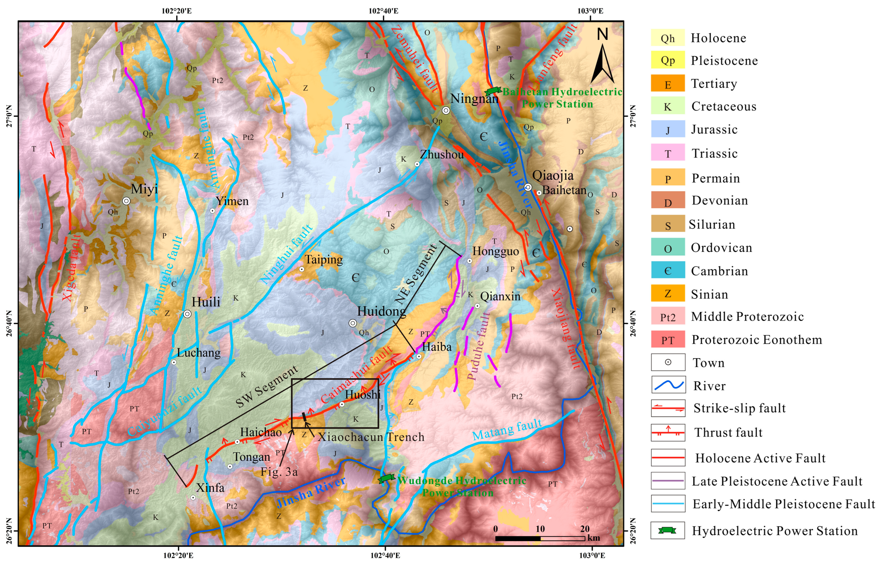
2. Regional Tectonic Setting

The Sichuan-Yunnan diamond-shaped block is situated in the main part of the southeastward extrusion of the Tibetan Plateau, and its periphery and interior are divided by several active faults [12,14,43]. The Lijiang-Xiaojinhe fault divides the Sichuan-Yunnan block into the northwestern Sichuan sub-block and the Central Yunnan sub-block, and the Zemuhe-Xiaojiang fault zone is located at the eastern boundary of the Central Yunnan sub-block [12]. The Zemuhe fault zone, approximately 120 km long, consists of three fault segments with a sinistral slip rate of 2.4–4.9 mm/a [44,45,46]. Several large earthquakes have occurred along the Zemuhe fault, the largest of which is the 1850 Xichang M7.5 earthquake, indicating the potential for large earthquakes in the southern segment of the Zemuhe fault zone [46,47,48,49,50,51]. The Xiaojiang fault zone, extending approximately 400 km, generally spreads in an arc with a slight convexity to the east (Figure 1) [26,35,52]. It strikes nearly north–south and is divided into north, middle, and south segments. The sinistral slip rate along the Xiaojiang fault zone varies from 12 to 15 mm/a in the north and central segments to 7 mm/a in the south segment [13,26,52,53,54,55]. According to historical earthquake records, significant earthquakes have occurred in the northern and middle segments including the 1500 Yiliang M7.0, 1733 Dongchuan M7.8, 1789 Huaning M7.0, and 1833 Songming M8.0 earthquakes, while the southern segment has no recorded of M ≥ 7.0 earthquakes, with only an M6.8 earthquake that occurred in Jianshui in 1606 [34,35,36]. Earthquakes frequently occur along and around the Xiaojiang fault; the seismicity of the northern and middle segments is significantly higher than that of the southern segment, with obvious spatial and temporal inhomogeneity of strong seismic activity. The southern segment represents a seismic gap with a high risk of strong earthquakes [26,47,56,57].
An NE-striking Ninghui fault exists between the Zemuhe and Anninghe faults, intersecting the Anninghe fault southwestward, passing northeastward through Luchang, Taiping, and Zhoushou, crossing the Zemuhe fault zone and connecting to the Lianfeng fault [17] (Figure 2). Satellite imagery reveals a continuous fault trough, with multiple mountains showing dextral displacement. The 1:200,000 geological map (https://www.ngac.org.cn) shows that the Ninghui fault is an Early-Middle Pleistocene fault. We did not find any newer activity phenomenon on this fault during the field survey. The Caimashui fault, located 30 km south of the Ninghui fault, is parallel to it. It is located on the west side of the Zemuhe-Xiaojiang fault zone, with striking northeast and dipping southeast. The Caimashui fault runs southwest from Hongguo County in Huidong County, through Haiba County, Huoshi County, and Haichao County, to near Xinfa Town in Huili County, spanning approximately 80 km. The Caimashui fault is an Early-Middle Pleistocene reverse fault according to a 1:200,000 geological map (https://www.ngac.org.cn) [58]. Moreover, a distinct lithological interface exists: Cambrian dolomite (Є), Cretaceous siltstone (K) and Proterozoic Eonothem (PT) are mainly distributed in the northwest wall, while Jurassic mudstone (J) and Sinian dolomitic limestone (Z) are mainly developed in the southeast wall (Figure 2).

3. Methods

3.1. Remote Sensing Interpretation

High-resolution remote sensing technology provides a fast and effective tool for quantitative research on active faults, enabling large-area investigations of active tectonic faults [59,60,61]. The interpretation of active fault characteristics using high-resolution remote sensing technology helps analyze fault geomorphology, such as faulted gullies and fluvial fans, and active fault-derived tectonic features, such as pull-apart basins, seismic bulges, and sag ponds [61,62]. Interpreting fault locations and geomorphic features from high-resolution remote sensing images is a preliminary step for field investigations. In this study, Google Earth satellite images were used to map fault traces.

3.2. UAV Measurement

Based on the geometrical distribution and geomorphological characteristics of the Caimashui fault, a UAV was used to measure and map the geomorphology of the fault and trench. The DJI “Phantom 4 RTK”, equipped with GNSS and RTK for real-time differential positioning with network base stations to obtain centimeter-level positioning accuracy, was used to measure the faulted geomorphology [63]. To obtain high-resolution digital orthophoto models (DOM) and digital elevation models (DEM), the flight altitude was set to 100–200 m. The UAV captured photographs of faulted landforms near the trench, which were processed using Pix4D Mapper software (version 1.4.46) to obtain a DEM with centimeter-level accuracy [64,65]. Using this software, the three-dimensional reconstructions were based on structure from motion (SfM) algorithms. Data processing is completed in seven steps: importing photos, aligning photos, optimizing alignment, creating a dense point cloud, generating grids and textures, and producing the DOM and DEM. These steps directly determine the resolution of the DOM and DEM. Using the high-resolution DEM, we interpreted faults and dislocated landforms and measured the offsets of landforms, such as terraces and gullies.

3.3. Trench

Trenching technology is the most direct and effective method for exposing surface rupture remnants of large earthquakes, determining the age, recurrence characteristics, and co-seismic displacements of large earthquakes, revealing fault activity, and assessing future earthquake hazards [66,67,68,69,70]. The location of the trench is critical for identifying event markers, with different types of faults requiring slightly different approaches for selecting trench locations. Strike-slip faults, for instance, have the advantages of stable extension on the strike, obvious geomorphic features, and good preservation for multiple earthquakes [68,69,70]. For strike-slip faults, continuous depositional terrains such as pull-apart basins, sag ponds, depression ponds, faulted terraces, and other areas where sampling materials can be collected are ideal. To reveal the latest activity era and paleoseismic events of the Caimashui fault, the Xiaochacun trench in the southwestern part of the fault was selected, where a fault trough developed between two ridges with young sediments (Figure 2). The trench was excavated perpendicular to the faulted scarp in the trough with a size of 15 m in length, 6 m in width, and 5 m in depth. After cleaning the trench walls, a 1 m × 1 m grid was established to identify stratigraphy and paleoseismic events. The geomorphology, stratigraphy, and paleoseismic events of the trench are detailed below.

3.4. Quaternary Dating

To determine the latest activity age, slip rate, and palaeoearthquake sequence of the Caimashui fault, 14C samples were collected from the trench. By analyzing the relationship between the depositional age of the stratigraphy, paleoseismic identification markers (e.g., colluvial wedge and fault scarp), and the time of earthquake events, we collected samples from corresponding locations to constrain the time of paleoearthquakes [70,71,72]. The 14C samples were tested at Beta Laboratories in the United States. The samples underwent acid-washing pretreatment before testing. The tests were completed using an NEC gas pedal mass spectrometer and Thermo IRMSs. Ages were corrected using the high-probability density range method (HPD) [73,74,75]. The test results of the samples are showed in Table 1.

4. Results

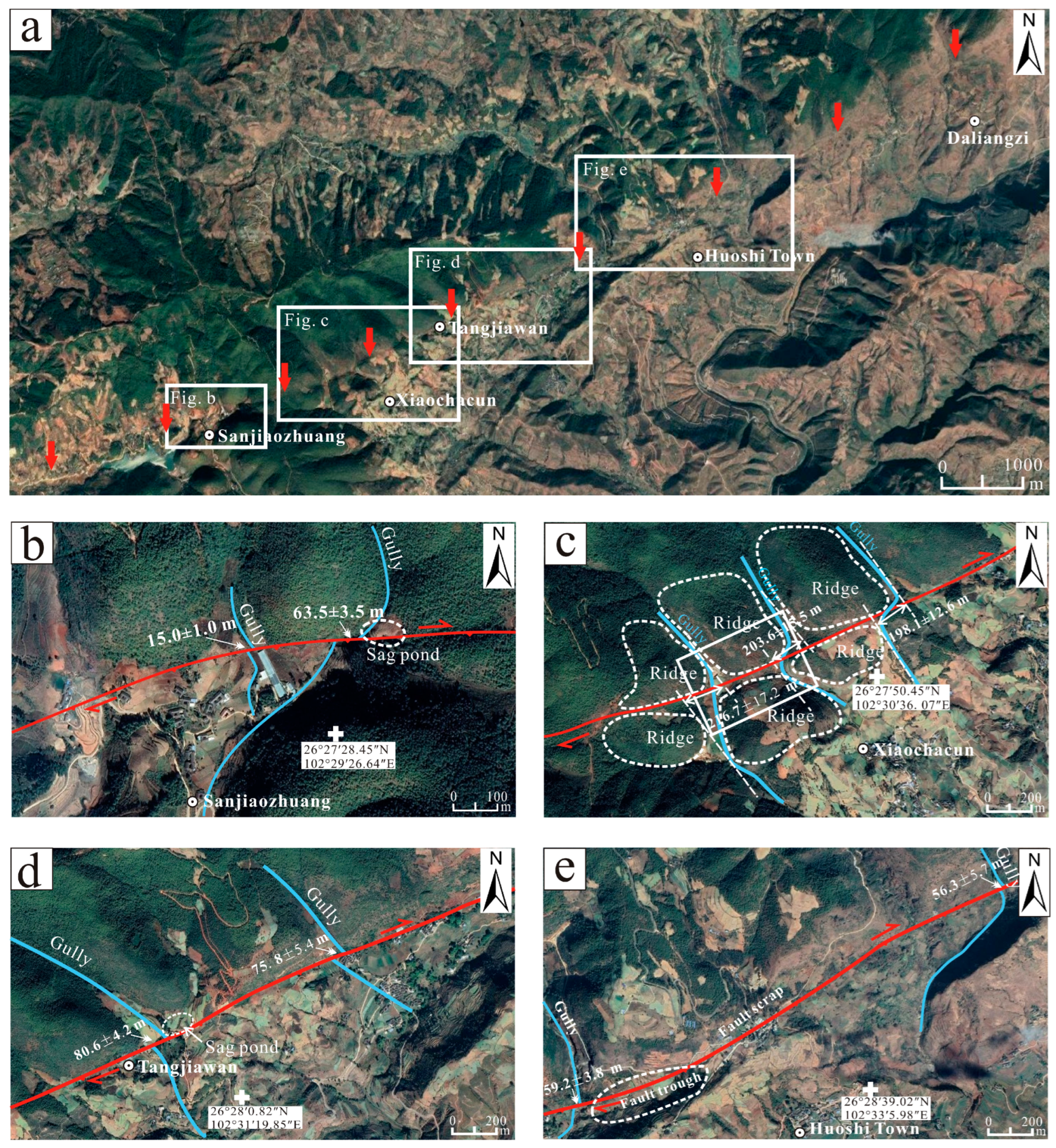
4.1. Google Earth Image Interpretation

Based on the change on fault strike and whether or not the fresh fault scarps developed, the Caimashui fault can be divided into two segments by Haiba Town: the NE segments, extending from Hongguo country to Haiba country with a length of 24 km, and the SW segment, extending from Haiba to Xinfa Town with a length of 58 km (Figure 2). In the NE segment, the strike of the fault changes to approximately NE30°, and the dextral dislocated gullies and ridges are developed linearly. However, no fresh fault scarp can be seen from the Google Earth satellite images and field investigation. In the SW segment, faulted landforms are linearly aligned in Google Earth satellite images. Along the SW segment, the Caimashui fault has developed various faulted landforms such as dislocated terraces, water systems, ridges, and flood fans, as well as tectonic landforms such as fault troughs, fault scarps, and sag ponds (Figure 3a).
At 400 m NE of Sanjiaozhuang, the fault displaced two gullies by 15 ± 1.0 m and 63 ± 3.5 m, forming a sag pond at the outflow of the gully (Figure 3b). At 630 m NW of Xiaochacun, the Caimashui fault passes through the valley, causing continuous dextral displacement of ridges and gullies by 216.7 ± 17.2 m, 203.6 ± 15.5 m, and 198.1 ± 12.6 m, respectively. A fault trough formed between the ridges, with the latest stratigraphy deposited in the troughs and valleys, making these locations ideal for excavating trenches to study paleoseismicity (Figure 3c). Near Tangjiawan, several gullies were synchronously displaced by 80.6 ± 4.2 m and 75.8 ± 5.4 m, with one of the gullies forming sag ponds at the faults (Figure 3d). Near Huoshi Town, the fault developed along the trough and displaced two gullies by 59.2 ± 3.8 m and 56.3 ± 5.7 m, respectively. A series of faulted troughs and scarps are visible, indicating fault traces (Figure 3e). All of these observations suggest that the Caimashui fault is likely a Late Quaternary active dextral strike-slip fault.

4.2. The Activity of the Caimashui Fault

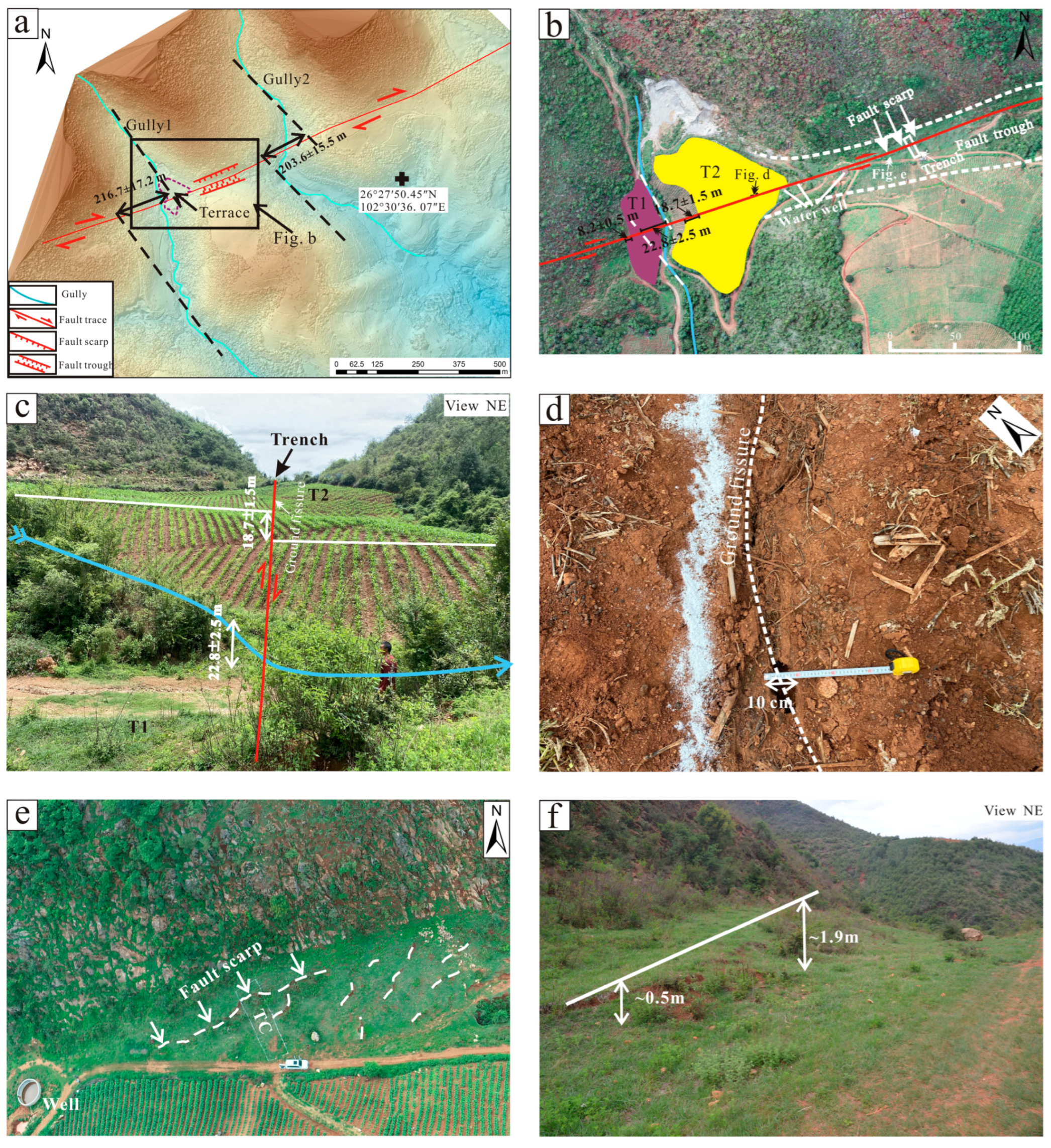
4.2.1. Trench Location and Landforms
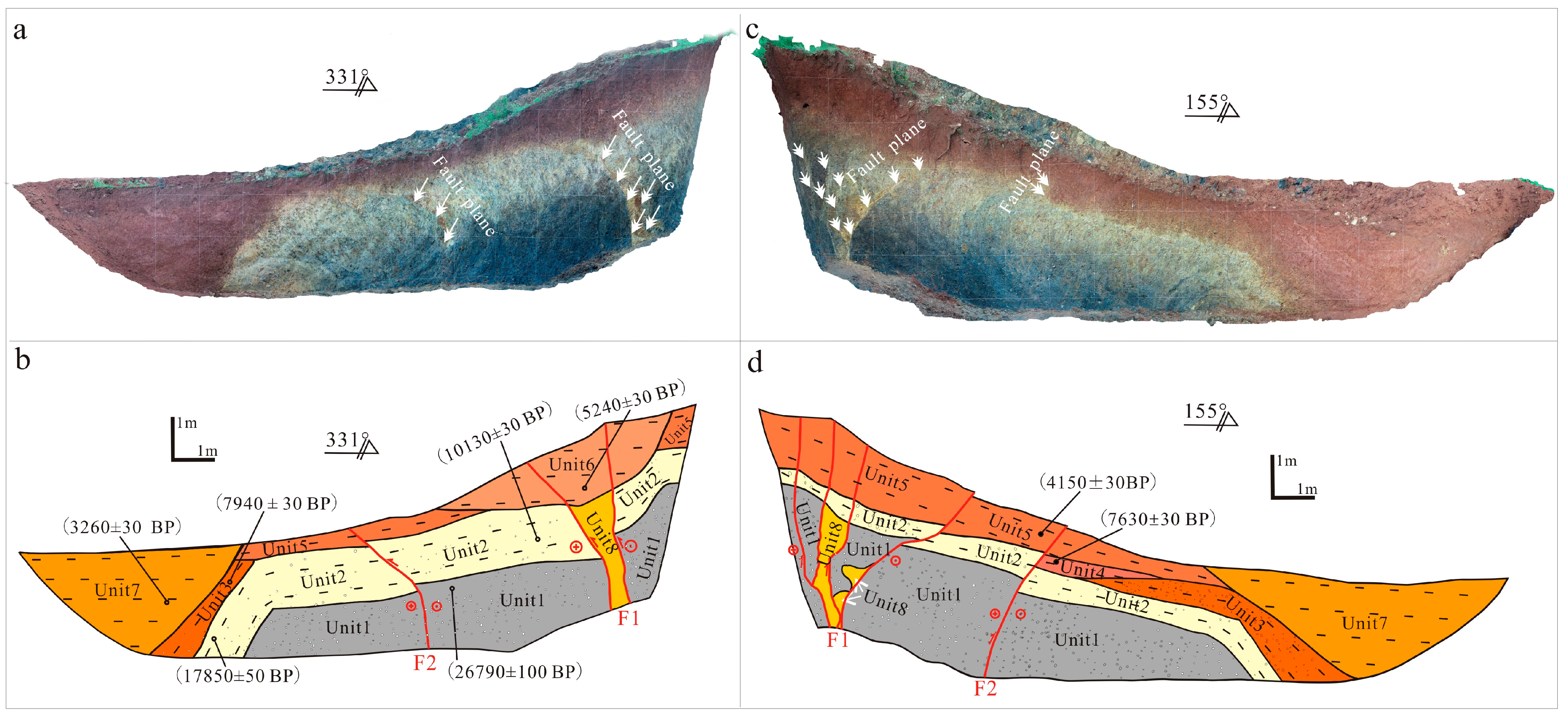
The NW plate of the Caimashui fault near the Xiaochacun trench mainly consists of Cambrian dolomite (Є), while the SE plate of the trench mainly consists of Sinian dolomitic limestone (Z) (Figure 2). Field investigations revealed that the Caimashui fault caused consistent dextral displacements of ridges and gullies 630 m northwest of Xiaochacun, with gullies displaced by 216.7 ± 17.2 m and 203.6 ± 15.5 m, respectively (Figure 4a). A straight, narrow fault trough, approximately 15–25 m wide (narrower on the western side and slightly wider on the eastern side), was developed between the two faulted ridges. The trough strikes NE60°, consistent with the fault direction. Within the trough, a fault scarp was observed, increasing in height eastward from 0.5 m to 1.9 m (Figure 4e,f). A brick-red clay layer, resembling Holocene sediments, is deposited in the trough.
West of gully 1, terrace T1 developed, with a height of approximately 4.5 ± 0.2 m and a dextral dislocation of 8.2 ± 0.5 m (Figure 4b). East of gully 1, a sag pond developed, which has evolved into terrace T2 due to the undercutting of the gully. The height of terrace T2 is approximately 8.6 ± 0.2 m, and its western edge is dislocated by 18.7 ± 1.5 m (Figure 4b). Terrace T2 developed a south-high, north-low fault scarp, and the lower part of the scarp developed a curved ground crack with a general strike of 66° and a width of approximately 2–3 cm, reaching up to 10 cm at its widest point (Figure 4d). Gully 1 shows a localized dextral strike distance of approximately 22.8 ± 2.5 m where the fault passes through (Figure 4c). Inside the fault trough, fault scarps are clear, with no traces of artificial modification. The sag pond provides an ideal depositional environment rich in organic material, making it suitable for searching for paleoseismic records (Figure 4e,f). Therefore, the trench was excavated perpendicular to the fault scarp (Figure 4e).

4.2.2. Stratigraphy

The Xiaochacun trench was excavated perpendicular to the fault scarp in the fault trough. The fault scarp is approximately 40 m long, strikes at approximately 63°, and increases in height gradually from west to east, reaching approximately 2 m. The scarp shows good continuity. First, the two trench walls were cleaned and divided into a 1 × 1 m grid. The trench profile was photographed using a UAV, and the images were spliced using Agisoft Metashape Pro 2.1.1 software [76]. Detailed descriptions of the strata and faults were conducted in the field after printing the trench profile, and 14C samples were collected from the marker layers for dating to constrain the age of the paleoseismic event. Based on similarities and differences in sedimentary phases, structures, and colors, the stratigraphy was divided into eight strata. Stratigraphic descriptions are outlined in Table 2 and Table 3.

4.2.3. Description of the Trench

The west wall of the Xiaochacun trench reveals two branch faults of the Caimashui fault, F1 and F2. Fault F1 is visible as a fault zone, approximately 30–40 cm wide at the bottom and gradually widening upward (Figure 5a,b). Fault F1 displaced the strata Unit1 and Unit2, which were dated to 26,790 ± 100a BP and 10,130 ± 30a BP, respectively (Figure 5b). The accumulation of Unit8 in the fault zone is disordered, predominantly consisting of orange clay blocks, likely involved in earthquake activities. The southern branch of fault F1 is clear and straight, featuring a white fault mud zone approximately 5 mm wide on the fault plane, while the northern boundary of fault F1 is blurred. The fault plane of fault F1 is evident in Unit1 and Unit2. Unit6 is a brownish purple-red clay layer formed by weathering of dolomite and limestone through slope flooding, with a 14C dating result of 5240 ± 30a BP, which corresponds to the middle Holocene. A fault scarp of approximately 1.7 m high was observed on the surface at this location, which is consistent with the vertical drop in Unit5 on both sides of the fault; this location coincides with fault F1. This suggests that fault F1 displaced Unit6, forming a scarp at the surface (Figure 4e), with its latest activity occurring after 5240 ± 30a BP.
Fault F2 is a single fault visible on the west wall of the Xiaochacun trench. It shows a clear fault plane in Unit1 and Unit2, with multiple grayish–yellow clay blocks involved in the hanging wall of the fault. The top surfaces of Unit1 and Unit2 exhibit significant drop-offs on either side of the fault (Figure 5a). Fault F2 displaced the bottom boundary of Unit5, indicating that the F2 activity occurred after the deposition of Unit5.
On the east wall of the Xiaochacun trench, fault zone F1 consists of at least 4–5 branching faults, which offset the Late Pleistocene strata Unit1 and Unit2. The top boundary of Unit2 shows clear serration and deformation corresponding to the branching faults of F1. This suggests that the faults continued to extend upward after faulting Unit2, affecting Unit5, and forming a fault scarp on the surface (Figure 5c,d). Fault F2 does not have an obvious fault plane in Unit1 and Unit2, but the black peat of Unit1 is clearly curved upward in the upper plate of the fault and rolled into Unit2 (Figure 5c). The top boundary of Unit2 is significantly displaced on both sides of fault F2, with a clear fault plane and a vertical drop of approximately 20–30 cm, forming a pre-scarp accumulation, Unit4, in the footwall of fault. This suggests that a surface rupture event of fault F2 occurred between Unit4 and Unit5. Sample LSZXCC-14C-TC1-07, taken from the upper part of Unit5, was dated at 4150 ± 30a BP, and sample LSZXCC-14C-TC1-08, taken from Unit4, was dated at 7630 ± 30a BP. This indicates that a seismic event occurred between 7630 ± 30a BP and 4150 ± 30a BP, possibly closer to 7630 ± 30a BP (Figure 5d). Subsequently, another earthquake faulted Unit5 and created a fault scarp on the surface. We constrained the time of this event to after 4150 ± 30 BP. This seismic event is consistent with the event revealed on the west wall of the trench.
Therefore, the Xiaochacun trench revealed that the Caimashui fault is a Holocene active reverse-dextral strike-slip fault with two paleoseismic events having occurred on it. The penultimate surface rupture event occurred between 7630 ± 30a BP and 4150 ± 30a BP (possibly closer to 7630 ± 30a BP), and the latest fault activity occurred later than 4150 ± 30 BP.

5. Discussion

5.1. Slip Rate of the Caimashui Fault

Field investigations and analysis of high-resolution remote sensing images indicate that the overall motion of the Caimashui fault is mainly dextral strike-slip. Along the fault traces, a series of dextral dislocations were observed including gullies, ridges, and terraces.
Based on the geomorphology of the sag ponds, gullies, and ridges, as well as the distribution characteristics of the faults in Xiaochacun, we reconstructed the formation and evolution of the sag ponds (Figure 6). The multiple times of dextral strike-slips of the fault produced dislocations in the corresponding ridges and gullies. At Xiaochacun, the ridges and gullies on the southeast side of the fault underwent synchronous westward movements relative to those on the northwestern side (Figure 6a,b). A faulted trough with a low-lying terrain formed between Ridges 2 and 2’. The dextral strike-slip fault movement caused displacements in Ridges 2’ and 3’ and blocked Gullies 1 and 2, forming Sag Ponds 1 and 2 (Figure 6c,d). Downstream, Gullies 1’ and 2’ were abandoned. Water from Gully 1 accumulated in Sag Pond 1 and gradually spread eastward toward the fault trough. The sediment in Sag Pond 1 gradually carbonized, forming a black carbon mud layer, which is observed as Unit 1 in the Xiaochacun trench (Figure 5a). As the water level in Sag Pond 1 rose, Gully 1 reconnected with Gully 1’ from the western part, causing the channel to undercut and Sag Pond 1 to be abandoned, forming a terrace. Subsequently, the fault dextrally displaced the gully and the terrace, creating a synchronous elbow-curved gully and terrace riser (Figure 6e,f). From Figure 4b, the dislocation distance of Gully 1 is measured to be 22.8 ± 2.5 m, and the dislocation distance of the terrace riser is measured to be 18.7 ± 1.5 m (Figure 4b). Since the displacement of Gully 1 is measured by the extension line, it may be larger than the true displacement. The lateral erosive action of the gullies can also lead to larger values. Therefore, we chose the dislocation distance of the terrace raiser (18.7 ± 1.5 m) and the abandonment age of Sag Pond 1 to calculate the dextral slip rate of the fault. The age of the sediments on the top of Unit 1 in the trench was dated to be 26,790 ± 100a BP (Figure 5b). Thus, the average dextral strike-slip rate of the Caimashui fault since the Late Pleistocene can be calculated to be 0.70 ± 0.11 mm/a.

5.2. Potential Seismic Hazard for the Caimashui Fault

Understanding the occurrence of surface rupture earthquakes on faults and studying their late Quaternary activity are of great significance for evaluating regional seismic hazards and planning large-scale projects. The activity level of the Caimashui fault varies significantly on both sides of Haiba County: the NE segment on the eastern side of Haiba County is an Early-Middle Pleistocene fault with a length of 24 km, while the SW segment on the western side of Haiba County is a Holocene fault with a length of 58 km. Combined with the linear geomorphology and paleoseismic data along the fault, the Caimashui fault is considered a newly generated Holocene active fault. Therefore, we mainly consider the SW segment when discussing the maximum potential magnitude of the earthquake that the Caimashui fault can generate. According to historical data, no surface rupture earthquakes have been recorded along the Caimashui fault. However, our study indicates that surface rupture events have occurred along the Caimashui fault since the Holocene. Field investigations revealed clear traces of the fault in the SW segment, with a young and fresh fault scarp near Xiaochacun, reaching a maximum height of 1.9 m. The maximum potential earthquake magnitude that the Caimashui fault can generate is estimated using empirical formulas that relate earthquake magnitude to surface rupture length, as shown in Table 4 [77,78,79,80]. Using a surface rupture length of 58 km in these empirical equations, we calculated the magnitudes as 7.04, 7.47, 7.38, and 7.47, with an average magnitude of 7.34. Therefore, the Caimashui fault is capable of generating M ≥ 7.0 earthquakes.
In recent years, a few studies have demonstrated that the intraplate region of the southeastern margin of the Tibetan Plateau is not a rigid block and that its intraplate faults, such as the Litang and Batang faults, exhibit significant characteristics of Holocene activity and the potential to generate strong earthquakes. Although their slip rate is low, this region has experienced many large earthquakes since the Late Quaternary [15,18,34,81]. To accommodate tectonic deformation caused by the eastward extrusion of the Tibetan Plateau, many secondary faults have developed to regulate strain distribution. These secondary faults within the active block, including the Caimashui fault, play an important role in regulating and accommodating crustal deformation. Their role is vital and should be emphasized in future surveys of active faults and regional seismic hazard assessments.

5.3. Faulting Pattern and Deformation Features

Although the slip rate of the Caimashui fault is relatively low within the Sichuan-Yunnan block, its role in regional crustal deformation is crucial for understanding the tectonic dynamics of secondary faults on the southeastern margin of the Tibetan Plateau. Geodetic data indicate that the southeastern margin of the Tibetan Plateau is bounded by the Xianshuihe-Xiaojiang and Shijie fault zones, which rotate clockwise around the Himalayan tectonic knot [53,82,83,84,85,86,87]. Inversion of the horizontal slip rate and seismic source mechanism, based on GPS data, show that the primary mode of motion on the southeast margin of the Tibetan Plateau is strike-slip; however, internal secondary faults also contribute to upper crustal deformation, and the occurrence of medium or large earthquakes on these faults indicates that the upper crust is not a rigid block rotating but rather exhibits diffuse deformation [88]. Based on seismicity and slip rates, Ji [88] classified the faults in the southeast margin of the Tibetan Plateau into three tiers: (1) first-tier faults: the Xianshuihe-Xiaojiang and Shijie fault zones, with a horizontal slip rate of ≥10 mm/a, are the most important boundary fault since the Late Quaternary. (2) Second-tier faults: these active tectonic faults have a horizontal slip rate of 3–6 mm/a. These faults divide the Sichuan-Yunnan block into several sub-blocks; for instance, the Litang sub-block is surrounded by the Litang and Xianshuihe faults, and the Lijiang-Xiaojinhe fault zone divides the Sichuan-Yunnan block into the northwestern Sichuan sub-block and the central Yunnan sub-block [8,89]. (3) Third-tier faults: These faults generally have a horizontal slip rate of ≤2 mm/a, typically generating earthquakes of magnitude 7 or less. They are generally small in size but numerous.
In the middle segment of the Xianshuihe-Xiaojiang fault system, the strike of the Xianshuihe, Zemuhe, and Xiaojiang fault zones changes from NW to near-SN, significantly influencing the propagation of the slip rate [17,90,91]. The decrease in the sinistral strike-slip rate from north to south of the Xiaojiang fault zone is absorbed by the reverse dextral strike-slip motion of the Qujiang and Shiping-Jianshui faults, which facilitate the translation and rotation of secondary blocks to accommodate overall deformation [4,16,26,55,87,91]. Within the secondary blocks, numerous third-tier faults regulate the internal motion, implying that these internal faults may directly or indirectly distribute boundary fault strain and influence tectonic evolution. Zhang [17] calculated the slip rate of the Xigeda fault to be 0.8–1.6 mm/a through a field survey, which compensates for the slip rate deficiencies of the Anninghe and Zemuhe faults, and together with the Yuanmou fault, divides the Central Yunnan sub-block into the Central Yunnan micro-block (CYMB) and the West Yunnan micro-block (WYMB). The CYMB, approximately 400 km long in the NS direction and 110 km wide in the EW direction, forms an NS-striking slender diamond block. The western boundary of the Xigeda-Yuanmou fault has a smaller sinistral strike-slip rate (1–2 mm/a) compared to the eastern boundary Xiaojiang fault zone (>10 mm/a); thus, the CYMB also needs to rotate counterclockwise (Figure 7a) [8]. However, given its slender shape, it is difficult for the CYMB to rotate as a whole, and it is more likely to be split by secondary faults into multiple blocks for self-rotation, a deformation pattern similar to that of the North China Plate [91,92]. The Caimashui fault, located in the middle of the CYMB, is an NE-striking reverse-dextral strike-slip fault with a slip rate of approximately 0.70 ± 0.11 mm/a. It may act as a secondary splitting fault, absorbing different sinistral strike-slip shear deformations from the boundary fault and the potential energy of the counterclockwise rotation of the CYMB (Figure 7b).

6. Conclusions

The Caimashui fault is a significant NE-trending dextral strike-slip fault within the Sichuan-Yunnan block. It shows obvious dextral strike-slip characteristics, as evident from remote sensing images. Detailed interpretation of satellite remote sensing images, field mapping, high-resolution geomorphological surveys, and trenching have revealed that the Caimashui fault is a dextral strike-slip fault with a reverse component. Based on UAV high-resolution geomorphological surveys and radiocarbon dating, the Late Quaternary dextral strike-slip rate of the Caimashui fault was estimated at 0.70 ± 0.11 mm/a. Paleoseismic investigations indicated that the most recent surface rupture of the Caimashui fault occurred after 4150 ± 30a BP, with a magnitude estimated to be M ≥ 7. Active tectonic activities around the Sichuan-Yunnan block indicate that the sinistral strike-slip rate of the Xiaojiang boundary fault zone is significantly higher than that of the Xigeda-Yuanmou fault zone, which causes the Central Yunnan microplate to rotate counterclockwise. Within the block, the Caimashui fault may act as a secondary splitting fault, accommodating the potential energy from the counterclockwise rotation of the CYMB.

Author Contributions

Conceptualization, K.L. and Z.H.; methodology, K.L.; software, X.T.; validation, X.T.; formal analysis, X.T. and K.L.; investigation, K.L. and X.T.; resources, K.L. and B.M.; data curation, X.T. and K.L.; writing—original draft preparation, X.T. and K.L.; writing—review and editing, X.T. and K.L.; visualization, X.T. and K.L.; supervision, K.L. and B.M.; project administration, K.L. and Z.H.; funding acquisition, K.L. and B.M. All authors have read and agreed to the published version of the manuscript.

Funding

This research was funded by the National Nature Science Foundation of China (grant number 42202253) and a Research Grant from the National Institute of Natural Hazards, Ministry of Emergency Management of China (grant numbers ZDJ2019-28 and ZDJ2019-21).

Data Availability Statement

Topographic data were obtained from https://earthexplorer.usgs.gov (accessed on 18 October 2023). Earthquake catalogue data were obtained from https://data.earthquake.cn (accessed on 25 October 2023). Regional lithological data were obtained from https://www.ngac.org.cn (accessed on 20 November 2023).

Acknowledgments

We thank Shimin Zhang, Qinjing Tian, Rongjun Zhou, Yongkang Ran, Zufeng Chang and Xiwei Xu for field instruction and discussion. We also thank the reviewers and editors for their assistance in improving our manuscript.

Conflicts of Interest

The authors declare no conflicts of interest.

References

  1. Tapponnier, P.E.; Peltzer, G.; Dain, A.; Armijo, R.; Cobbold, P.R. Propagating extrusion tectonics in Asia: New insights from simple experiments with plasticine. Geology 1982, 10, 611–616. [Google Scholar] [CrossRef]
  2. Tapponnier, P.E.; Xu, Z.Q.; Roger, F.; Meyer, B.; Arnaud, N.; Wittlinger, G.R.; Yang, J.S. Oblique Stepwise Rise and Growth of the Tibet Plateau. Science 2001, 294, 1671–1677. [Google Scholar] [CrossRef] [PubMed]
  3. Wen, X.Z.; Huang, S.M.; Jiang, Z.X. Neotectonic features of the Ganzi-Yushu fault zone and assessment of its earthquake risk. Seismol. Geol. 1985, 7, 23–32. [Google Scholar]
  4. He, H.L.; Li, P.; Fang, Z.J. Analysis of seismogenic conditions in the wedge tectonic region of southeast Yunnan Province. Seismol. Geol. 1992, 14, 217–226. [Google Scholar]
  5. Molnar, P.H.; England, P.C.; Martinod, J. Mantle dynamics, uplift of the Tibetan Plateau, and the Indian Monsoon. Rev. Geophys. 1993, 31, 357–396. [Google Scholar] [CrossRef]
  6. Chen, Z.; Burchfiel, B.C.; Liu, Y.; King, R.; Royden, L.H.; Tang, W.H.; Wang, E.; Zhao, J.; Zhang, X. Global Positioning System measurements from eastern Tibet and their implications for India/Eurasia intercontinental deformation. J. Geophys. Res. 2000, 105, 16215–16227. [Google Scholar] [CrossRef]
  7. Yin, A.; Harrison, T. Geologic evolution of the Himalayan-Tibetan Orogen. Annu. Rev. Earth Planet Sci. 2000, 28, 211–280. [Google Scholar] [CrossRef]
  8. Deng, Q.D.; Zhang, P.Z.; Ran, Y.K.; Yang, X.; Min, W.; Chu, Q.Z. Basic characteristics of active tectonics of China. Sci. China Ser. D Earth Sci. 2003, 46, 356–372. [Google Scholar] [CrossRef]
  9. Zhang, P.Z.; Deng, D.Q.; Zhang, G.M.; Ma, J.; Gan, W.J.; Min, W.; Mao, F.Y.; Wang, Q. Active tectonics blocks and strong earthquakes in the continent of China. Sci. China Ser. D Earth Sci. 2003, 33, 12–20. [Google Scholar] [CrossRef]
  10. Replumaz, A.; Tapponnier, P.E. Reconstruction of the deformed collision zone Between India and Asia by backward motion of lithospheric blocks. J. Geophys. Res. 2003, 108, 2285. [Google Scholar] [CrossRef]
  11. Yuan, D.Y.; Ge, W.P.; Chen, Z.W.; Li, C.Y.; Wang, Z.C.; Zhang, H.P.; Zhang, P.Z.; Zheng, D.W.; Zheng, W.J.; Craddock, W.H.; et al. The growth of northeastern Tibet and its relevance to large-scale continental geodynamics: A review of recent studies. Tectonics 2013, 32, 1358–1370. [Google Scholar] [CrossRef]
  12. Cheng, J.; Xu, X.W.; Gan, W.J.; Ma, W.T.; Chen, W.T.; Zhang, Y. Block model and dynamic implication from the earthquake activity and crustal motion in the southeastern margin of Tibetan Plateau. Chin. J. Geophys. 2012, 55, 1198–1212. [Google Scholar] [CrossRef]
  13. Wu, Z.H.; Long, C.X.; Fan, T.Y.; Zhou, C.J.; Feng, H.; Yang, Z.Y.; Tong, Y.B. The arc rotational-shear active tectonic system on the southeastern margin of Tibetan Plateau and its dynamic characteristics and mechanism. Geol. Bull. China 2015, 34, 1–31. [Google Scholar]
  14. Xu, X.W.; Wen, X.Z.; Zheng, R.Z.; Ma, W.T.; Song, F.M.; Yu, G.H. The structural styles and dynamic source of Sichuan-Yunnan rhombic block. Sci. China Ser. D 2003, 33, 151–162. [Google Scholar]
  15. Han, Z.J.; Guo, S.M.; Xiang, H.F.; Zhang, J.S.; Ran, Y.K. Seismotectonic environment of occurring the February 3, 1996 Lijiang M = 7.0 earthquake, Yunnan Province. Acta Seismol. Sin. 2004, 26, 410–418. [Google Scholar] [CrossRef]
  16. Wang, Y.; Zhang, B.; Hou, J.J.; Xu, X.W. Structure and tectonic geomorphology of the Qujiang fault at the intersection of the Ailao Shan–Red River fault and the Xianshuihe–Xiaojiang fault system, China. Tectonophysics 2014, 634, 156–170. [Google Scholar] [CrossRef]
  17. Zhang, W.; Liu, Y.F.; Sun, H.Y.; He, Y.L.; Ma, C.; Liu, S.; Yang, D.B. Holocene activity of the Xigeda fault and its implications for the crustal deformation pattern in the southeastern Tibetan Plateau. Tectonics 2021, 40, e2021TC007056. [Google Scholar] [CrossRef]
  18. Gao, S.P.; Chen, L.C.; Li, Y.B.; Wang, H.; Han, M.M.; Feng, J.H.; Lu, L.L.; Peng, S.X.; Jin, C.; Liu, L.T. Rupture behavior of the Litang Fault within the Sichuan-Yunnan active block, Southeastern Tibetan Plateau. Lithosphere 2021, 8773676. [Google Scholar] [CrossRef]
  19. Wei, S.J.; Zeng, H.Y.; Shi, Q.B.; Liu, J.H.; Luo, H.; Hu, W.L.; Li, Y.; Wang, W.T.; Ma, Z.F.; Liu, J.; et al. Simultaneous rupture propagation through fault bifurcation of the 2021 Mw7.4 Maduo earthquake. Geophys. Res. Lett. 2022, 49, e2022GL100283. [Google Scholar] [CrossRef]
  20. Pan, J.W.; Li, H.B.; Chevalier, M.L.; Tapponnier, P.E.; Bai, M.K.; Li, C.; Liu, F.C.; Liu, D.L.; Wu, K.G.; Wang, P.; et al. Co-seismic rupture of the 2021, M7.4 Maduo earthquake (northern Tibet): Short-cutting of the Kunlun fault big bend. Earth Planet. Sci. Lett. 2022, 2022, 117703. [Google Scholar] [CrossRef]
  21. Ha, G.H.; Liu, J.R.; Ren, Z.K.; Zhu, X.X.; Bao, G.D.; Wu, D.Y.; Zhang, Z.L. The interpretation of seismogenic fault of the Maduo Mw 7.3 Earthquake, Qinghai based on remote sensing images—A branch of the East Kunlun Fault System. J. Earth Sci. 2022, 33, 857–868. [Google Scholar] [CrossRef]
  22. Zhang, S.C.; Liu, B.H. Seismic geological characteristics of Tonghai earthquake in 1970. Sci. Geol. Sin. 1978, 4, 323–335. [Google Scholar]
  23. Zhu, C.N. Qujiang Fault geometry and its relation to seismicity. J. Seismol. Res. 1984, 7, 525–532. [Google Scholar]
  24. Han, M.K.; Chai, T.J.; Li, Z.X. Morphotectonic features of the Tonghai earthquake region, Yunnan province. Acta Geogr. Sin. 1983, 38, 41–54. [Google Scholar]
  25. Liu, Z.Y.; Huang, P.G.; Jin, Z.L. 1970 Tonghai Earthquake; Seismological Publishing Press: Beijing, China, 1999. [Google Scholar]
  26. Wen, X.Z.; Du, F.; Long, F.; Fan, J.; Zhu, H. Tectonic dynamics and correlation of major earthquake sequences of the Xiaojiang and Qujiang-Shiping fault systems, Yunnan, China. Sci. China Earth Sci. 2011, 41, 713–724. [Google Scholar] [CrossRef]
  27. Ren, J.J.; Xu, X.W.; Yeats, R.S.; Zhang, S.M. Latest Quaternary paleoseismology and slip rates of the Longriba fault zone, eastern Tibet: Implications for fault behavior and strain partitioning. Tectonics 2013, 32, 216–238. [Google Scholar] [CrossRef]
  28. Sun, H.Y.; He, H.L.; Wei, Z.Y.; Shi, F.; Gao, W. Late Quaternary paleoearthquakes along the northern segment of the Nantinghe fault on the southeastern margin of the Tibetan Plateau. J. Asian Earth Sci. 2017, 138, 258–271. [Google Scholar] [CrossRef]
  29. Li, P.; Wang, L.M. Exploration of the seismic geological features of the Yunnan-west Sichuan region. Chin. J. Geol. 1975, 4, 308–326. [Google Scholar]
  30. Kan, R.J.; Zhang, S.C.; Yan, F.T.; Yu, L.S. Present tectonic stress field and its relation to the characteristics of recent tectonic activity in southeastern China. Acta Geophys. Sin. 1977, 20, 96–109. [Google Scholar]
  31. Li, P. Xianshuihe-Xiaojiang Fault Zone; Earthquake Press: Beijing, China, 1993. [Google Scholar]
  32. Wen, X.Z. Rupture segmentation and probabilistic estimation of seismic potential in the Xiaojiang fault zone. J. Earthq. Sci. 1993, 15, 322–330. [Google Scholar]
  33. He, H.L.; Fang, Z.J.; Li, P. A preliminary approach to the fault activity of southern segment on Xiaojiang West Branch Fault. J. Seismol. Res. 1993, 16, 291–298. [Google Scholar]
  34. China Earthquake Administration. The Catalogue of Chinese Historical Strong Earthquakes; Seismological Press: Beijing, China, 1995.
  35. Song, F.M.; Wang, Y.P.; Yu, W.X.; Cao, Z.Q.; Shen, X.H.; Shen, J. Xiaojiang Active Fault; Seismological Publishing Press: Beijing China, 1998. [Google Scholar]
  36. China Earthquake Administration. Recent Earthquake Catalog of China (1912–1990, Ms ≥ 4.7); Chinese Sciences and Technology Press: Beijing, China, 1999.
  37. Lu, H.F.; Ji, Z.J. Activity characteristics on the Xigeda fault in the Late Quaternary and recrudescing interval of the strong earthquake. Geoscience 2011, 25, 440–446. [Google Scholar]
  38. Lu, H.F. Neotectonic significance of the Yuanmou-Xigeda fault in the Late Cenozoic. Sci. Bull. 2014, 59, 2877–2890. [Google Scholar] [CrossRef]
  39. Zhang, Y.B. Studies on the late Quaternary tectonic deformation of the Xigeda Fault. Master’s Thesis, Institute of Earthquake Forcasting, China Earthquake Administration, Beijing, China, 2022. [Google Scholar]
  40. Zhang, W.S.; Lu, H.F. Late Cenozoic tectonic stress field of Xigeda fault. J. Geod. Geodyn. 2017, 27, 1010–1014. [Google Scholar]
  41. Deng, Q.D.; Ran, Y.K.; Yang, X. Active Tectonics Map of China (1:4000000); Seismological Press: Beijing China, 2007. [Google Scholar]
  42. China Earthquake Networks Center. Seismological Data Search System. 2021. Available online: http://www.ceic.ac.cn/history (accessed on 15 July 2024).
  43. Zhang, P.Z.; Deng, Q.D.; Zhang, Z.Q.; Li, H.B. Active faults, earthquake hazards and associated geodynamic processes in continental China. Sci. China. Earth Sci. 2013, 43, 1607–1620. [Google Scholar]
  44. Ren, J.W. Late Quaternary displacement and slip rate of Zemuhe Fault in Sichuan, China. Seismol. Geol. 1994, 16, 146. [Google Scholar]
  45. He, H.L.; Song, F.M.; Li, C.Y. Topographic survey of micro faulted landform and estimation of strike slip rate for the Zemuhe Fault, Sichuan Province. Seismol. Geol. 1999, 21, 361–369. [Google Scholar]
  46. Wang, H.; Ran, Y.K.; Li, Y.B. Growth of a small pull-apart basin and slip rate of strike-slip fault: With the example of Zemuhe Fault on the southeastern margin of the Tibetan Plateau. Seismol. Geol. 2011, 33, 818–827. [Google Scholar]
  47. Yi, G.X.; Wen, X.Z.; Fan, J.; Wang, S.W. Assessing current faulting behaviors and seismic risk of the Anninghe-Zemuhe fault zone from seismicity parameters. Acta Seismol. Sin. 2004, 26, 294–303. [Google Scholar] [CrossRef]
  48. Han, W.B.; Jiang, G.F. Study on seismicity of Daliangshan and Anninghe-Zemuhe fault zones. J. Seismol. Res. 2005, 28, 207–212. [Google Scholar]
  49. Tian, Q.J.; Ren, Z.K.; Zhang, J.L. Study of paleoearthquakes by combined trench on Zemuhe fault around Daqingliangzi, Xichang, Sichuan. Seismol. Geol. 2008, 30, 400–411. [Google Scholar]
  50. Zhu, A.L.; Xu, X.W.; Gan, W.J.; Chen, G.H. The possible asperities on the Xianshuihe-Anninghe-Zemuhe Fault Zone: Evidence from background seismicity. Earth Sci. Front. 2009, 16, 218–225. [Google Scholar]
  51. Ren, Z.K.; Lin, A.; Rao, G. Late Pleistocene–Holocene activity of the Zemuhe Fault on the southeastern margin of the Tibetan Plateau. Tectonophysics 2010, 495, 324–336. [Google Scholar] [CrossRef]
  52. Han, Z.J.; Dong, S.P.; Mao, Z.B.; Hu, N.; Tan, X.B.; Yuan, R.M.; Guo, P. The Holocene activity and strike-slip rate of the southern segment of Xiaojiang Fault in the southeastern Yunnan region, China. Seismol. Geol. 2017, 39, 1–19. [Google Scholar]
  53. Shen, Z.K.; Lü, J.N.; Wang, M.; Bürgmann, R. Contemporary crustal deformation around the Southeast borderland of the Tibetan Plateau. J. Geophys. Res. Solid Ear. 2005, 110, B11409. [Google Scholar] [CrossRef]
  54. Wang, Y.Z.; Wang, E.N.; Shen, Z.K.; Wang, M.; Gan, W.J.; Qiao, X.J.; Meng, G.J.; Li, T.M.; Tao, W.; Yang, Y.L.; et al. GPS-constrained inversion of present-day slip rates along major faults of the Sichuan-Yunnan region, China. Sci. China Ser. D Earth Sci. 2008, 51, 1267–1283. [Google Scholar] [CrossRef]
  55. Hu, M.M.; Wu, Z.H.; Li, J.C.; Huang, X.L. The Late Quaternary strike-slip rate of the Qiaojia segment of the Xiaojiang fault zone. Acta Geol. Sin. 2023, 97, 16–29. [Google Scholar]
  56. Mao, Y.; Liu, Z.F.; Ye, J.Q.; Li, Z.H. Analysis on strong earthquake risk of Xiaojiang Fault Zone. J. Seismol. Res. 2016, 39, 213–217. [Google Scholar]
  57. Tan, X.; Liang, K.; Ma, B.Q. A review of research progress on the late quaternary activities of the Xiaojiang Fault Zone. Technol. Earthq. Disasters Prevent 2023, 18, 757–772. [Google Scholar]
  58. Wang, S.W.; Sun, X.M.; Liao, Z.W.; Qu, W.J.; Yang, B.; Jiang, X.F.; Li, C.; Li, Y.C. Platinum group elements and Re-Os isotope geochemistry of harzburgites from Caiziyuan nickel deposit in Huili County of Sichuan Province and its geological significance. Miner. Depos. 2013, 32, 515–532. [Google Scholar]
  59. He, H.L. Some problems of aerial photo interpretation in active fault mapping. Seismol. Geol. 2011, 938–950. [Google Scholar] [CrossRef]
  60. Zhang, J.F.; Jiang, W.L.; Tian, T.; Wang, X. High resolution remote sensing application research in active fault surveying. Acta Seismol. Sinca 2016, 38, 386–398. [Google Scholar] [CrossRef]
  61. Jiang, W.L.; Zhang, J.F.; Shen, X.H.; Jiao, Q.S.; Tian, T.; Wang, X. Geometric and geomorphic features of active fault structures interpreted from high-resolution remote sensing data. J. Remote Sens. 2018, 22, 192–211. [Google Scholar]
  62. He, Z.T.; Ma, B.Q. Holocene paleoearthquakes of the Daqingshan fault detected from knickpoint identification and alluvial soil profile. J. Asian Earth Sci. 2015, 98, 261–271. [Google Scholar] [CrossRef]
  63. Zhang, Z.W.; Ren, J.J.; Zhang, X.L. Application of high-precision UAV aerial survey in the detailed study of surface rupture of Maduo MS7.4 earthquake in 2021. Technol. Earthq. Disasters Prevent 2021, 16, 437–447. [Google Scholar]
  64. Bemis, S.P.; Micklethwaite, S.; Turner, D.; James, M.R.; Akciz, S.; Thiele, S.T.; Bangash, H.A. Ground-based and UAV-based photogrammetry: A multi-scale, high-resolution mapping tool for structural geology and paleoseismology. J. Struct. Geol. 2014, 69, 163–178. [Google Scholar] [CrossRef]
  65. Gao, M.X.; Xu, X.W.; Klinger, Y.; Woerd, J.; Tapponnier, P.E. High-resolution mapping based on an Unmanned Aerial Vehicle (UAV) to capture paleoseismic offsets along the Altyn-Tagh fault, China. Sci. Rep. 2016, 7, 8281. [Google Scholar] [CrossRef]
  66. Wallace, R.E. Active faults, paleoseismology, and earthquake hazards in the western United States. In Earthquake Prediction–An International Review; Simpson, D.W., Richards, P.G., Eds.; Maurice Ewing Series; American Geophysical Union: Washington, DC, USA, 1981; pp. 209–216. [Google Scholar]
  67. Crone, A.J. Introduction to Directions in Paleoseismology; US Geological Survey Open File Report; U.S. Geological Survey: Reston, VA, USA, 1987; pp. 87–683.
  68. Deng, Q.D.; Wen, X.Z. A review on the research of active tectonics-History, progress and suggestions. Seismol. Geol. 2008, 30, 1–30. [Google Scholar]
  69. Ran, Y.K.; Wang, H.; Li, Y.B.; Chen, L.C. Key techniques and several cases analysis in paleoseismic studies in mainland China(1): Trenching sites, layouts and paleoseismic indicators on active strike-slip faults. Seismol. Geol. 2012, 34, 197–210. [Google Scholar]
  70. Yuan, Z.D.; Liu, J.; Li, Z.F.; Shao, Y.X.; Li, Z.G.; Wang, P.; Wang, W.; Yao, W.Q. Tecto-geomorphic analysis of paleoseismic trenching sites on active strike-slip faults. Geol. Bull. China 2016, 35, 1807–1828. [Google Scholar]
  71. Deng, Q.D.; Chen, L.C.; Ran, Y.K. Quantitative studies and applications of active tectonics. Earth Sci. Front. 2004, 11, 383–392. [Google Scholar]
  72. Ran, Y.K.; Wang, H.; Yang, H.L.; Xu, L.X. Key techniques and several cases analysis in paleoseismic studies in mainland China(4)—Sampling and event analysis of paleoseismic dating methods. Seismol. Geol. 2014, 36, 939–955. [Google Scholar]
  73. Lienkaemper, J.J.; Ramsey, C.B. OxCal: Versatile tool for developing paleoearthquake chronologies—A primer. Seismol. Res. Lett. 2009, 80, 431–434. [Google Scholar] [CrossRef]
  74. Ramsey, C.B. Bayesian analysis of radiocarbon dates. Radiocarbon 2009, 51, 337–360. [Google Scholar] [CrossRef]
  75. Reimer, P.J.; Austin, W.E.; Bard, E. The IntCal20 Northern hemisphere radiocarbon age calibration curve (0–55 cal kBP). Radiocarbon 2020, 62, 725–757. [Google Scholar] [CrossRef]
  76. Reitman, N.G.; Bennett, S.E.K.; Gold, R.D.; Briggs, R.W.; DuRoss, C.B. High-resolution trench photomosaics from image-based modeling: Workflow and error analysis. Bull. Seismol. Soc. Am. 2015, 105, 2354–2366. [Google Scholar] [CrossRef]
  77. Wells, D.L.; Coppersmith, K.J. New empirical relationships among magnitude, rupture length, rupture width, rupture area, and surface displacement. Bull. Seismol. Soc. Am. 1994, 84, 974–1002. [Google Scholar] [CrossRef]
  78. Deng, Q.D.; Yu, G.H.; Ye, W.H. Research on the relationship between earthquake surface rupture parameters and magnitude. In Research on Active Fault; Earthquake Press: Beijing, China, 1992; pp. 247–264. [Google Scholar]
  79. Ran, H.L. Empirical relations between earthquake magnitude and parameters of strike-slip seismogenic active faults associated with historical earthquakes in western China. Seismol. Geol. 2011, 33, 577–585. [Google Scholar]
  80. Huang, J.Y. Research on the Method for Evaluating the Earthquake Surface Rupture. Ph.D. Thesis, Institute of Engineering Mechanics, China Earthquake Administration, Harbin, China, 2016. [Google Scholar]
  81. Han, M.M.; Chen, L.C.; Li, Y.B.; Gao, S.P.; Feng, J.H. Paleoearthquakes of the Yangda-Yaxu fault across the Nujiang suture and Lancang river suture zone, southeastern Tibetan Plateau. Front. Earth Sci. 2022, 10, 990187. [Google Scholar] [CrossRef]
  82. England, P.; Molnar, P. Right-lateral shear and rotation as the explanation for strike-slip faulting in eastern Tibet. Nature 1990, 344, 140–142. [Google Scholar] [CrossRef]
  83. Zhang, P.Z.; Shen, Z.K.; Wang, M.; Gan, W.J.; Bürgmann, R.; Molnar, P. Continuous deformation of the Tibetan Plateau from global positioning system data. Geology 2004, 32, 809–812. [Google Scholar] [CrossRef]
  84. Zhang, P.Z.; Wang, W.T.; Gan, W.J.; Zhang, Z.Q.; Zhang, H.P.; Zheng, D.W.; Zheng, W.J.; Wang, Y.; Wang, Y.J.; Xu, B.B.; et al. Present-day deformation and geodynamics processes of the Tibetan Plateau. Acta Geol. Sin. 2022, 96, 3297–3313. [Google Scholar]
  85. Gan, W.J.; Zhang, P.Z.; Shen, Z.K.; Niu, Z.J.; Wang, M.; Wang, Y.G.; Zhou, D.M.; Cheng, J. Present-day crustal motion within the Tibetan Plateau inferred from GPS measurements. J. Geophys. Res. 2007, 112, B08416. [Google Scholar] [CrossRef]
  86. Gan, W.J.; Molnar, P.; Zhang, P.Z.; Xiao, G.R.; Liang, S.M.; Zhang, K.L.; Li, Z.J.; Xu, K.K.; Zhang, L. Initiation of clockwise rotation and eastward transport of Southeastern Tibet inferred from deflected fault trace sand GPS observations. Geol. Soc. Am. Bull. 2021, 134, 1129–1142. [Google Scholar] [CrossRef]
  87. Wang, M.; Shen, Z.K. Present-day crustal deformation of continental China derived from GPS and its tectonic implications. J. Geophys. Res. 2020, 125, e2019JB018774. [Google Scholar] [CrossRef]
  88. Ji, H.M.; Ren, Z.K.; Liu, J.R. Review of structural deformation in the upper crust of the Southeastern margin of the Tibetan Plateau since the Late Cenozoic. Earth Sci. 2023, 49, 480–499. [Google Scholar] [CrossRef]
  89. Fan, C.; Wang, G.; Wang, S.F.; Wang, E. Structural interpretation of extensional deformation along the Dali Fault system, southeastern margin of the Tibetan Plateau. Inter. Geol. Rev. 2006, 48, 287–310. [Google Scholar] [CrossRef]
  90. Lozos, J.C.; Oglesby, D.D.; Duan, B. The effects of double fault bends on rupture propagation: A geometrical parameter study. Bull. Seismol. Soc. Am. 2011, 101, 385–398. [Google Scholar] [CrossRef]
  91. Zhang, Y.; Zheng, W.; Wang, Y.; Zhang, D.; Tian, Y.; Wang, M.; Zhang, Z.; Zhang, P. Contemporary deformation of the North China Plain from global positioning system data. Geophys. Res. Lett. 2018, 45, 1851–1859. [Google Scholar] [CrossRef]
  92. Tan, X.; Liang, K.; Ma, B.; He, Z.; Liu, G.; Li, Z.; Li, L.; Zhao, J. A catastrophic, buried fault-generating earthquake: The 1937 M7.0 Heze earthquake in the south-central North China Plain. J. Struct. Geol. 2023, 177, 104988. [Google Scholar] [CrossRef]
Figure 1. Tectonic setting and distribution map of the southeast margin of the Tibetan Plateau. (a) Tectonic location of the study area. Black rectangle shows the study area. ATF: Altyn Tagh fault, QHF: Qilian-Haiyuan fault, KF: Kunlunshan fault, XF: Xianshuihe fault, XJF: Xiaojiang fault, RRF: Red River fault, JLF: Jiali fault, CF: Karakorum fault, HFT: Himalayan Frontal Thrust. (b) Main active tectonics in the study area. The fault locations are modified from [41]. Colored circles represent historically and instrumentally documented earthquakes, which are modified from [34,36,42]. XF: Xianshuihe fault, ANHF: Aninghe fault, ZMHF: Zemuhe fault, DLSF: Daliangshan fault, LMSFZ: Longmenshan fault zone, LJ-XJHF: Lijiang-Xiaojinhe fault, XGDF: Xigeda fault, YMF: Yuanmou fault, CMSF: Caimashui fault, QJF: Qujiang fault, SJF: Shiping-Jianshui fault.
Remotesensing 16 03203 g001
Figure 2. Geological features and fault distributions near the Caimashui fault. Lithological data are obtained from 1:200,000 geologic maps (https://www.ngac.org.cn).
Remotesensing 16 03203 g002
Figure 3. Tectonic landforms caused by the Caimashui fault near Huoshi Town (see location in Figure 2). (a) Satellite image (from Google Earth) of the fault trace. (b) Tectonic landforms around the Sanjiaozhuang site. (c) Tectonic landforms around the Xiaochacun site. (d) Tectonic landforms around the Tangjiawan site. (e) Tectonic landforms around the Huoshi Town site. For locations, see Figure 3a. Red arrows and red lines indicate the location of the fault.
Remotesensing 16 03203 g003
Figure 4. Tectonic landforms around the Xiaochacun trench; see location in Figure 3c. (a) Shaded relief map (from UAV-derived DEM) and interpreted map, showing the fault scarp, fault trough, and offset terrace. (b) Aerial image showing the tectonic landforms along the fault. (c) Field photo of the offset terrace. (d) Field photo of the ground fissures. (e) Aerial photo of the Xiaochacun trench, with broken white lines indicating fault scarps. (f) Field photo of the fault scarp.
Remotesensing 16 03203 g004
Figure 5. (a) Photo mosaic and (b) interpreted map of the west wall of the Xiaochacun trench. (c) Photo mosaic and (d) interpreted map of the east wall of the Xiaochacun trench. Black lines indicate the stratigraphic contacts between units. Red lines indicate the fault planes. Black dots show the locations of the radiocarbon samples, labeled with their corresponding calibrated ages.
Remotesensing 16 03203 g005
Figure 6. Sketch maps showing the formation and evolution of sag ponds in Xiaochacun. (a,b) Ridges and gullies before the formation of the sag ponds; (c,d) show the fault displacing the ridges, leading to the formation of sag ponds 1 and 2; (e,f) show the gullies cutting through the sag ponds, resulting in the abandonment of the sag ponds and their subsequent displacement by ongoing fault activity.
Remotesensing 16 03203 g006
Figure 7. Geometrical and tectonic model of the Sichuan-Yunnan tectonic zone. (a) Fault slip rates and the distribution of strong earthquakes on the Sichuan-Yunnan block. (b) A cartoon model showing that the slip rate difference between the left-slip faults and right-slip faults inside the block leads to counterclockwise rotation (modified from [8]). WYMB: West Yunnan microblock; CYMB: Central Yunnan microblock; NCF: Nanhua-Chuxiong fault; JSJF: Jinshajiang fault; SJF: Shiping-Jianshui fault; QJF: Qujiang fault.
Remotesensing 16 03203 g007
Table 1. Test results for 14C samples from the Xiaochacun trench.
IDLab No.Radiocarbon Age (a BP) Correction Age (cal B.P.)Description
LSZXCC-TC1-14C-015986987940 ± 308815–8640Organic sediment
LSZXCC-TC1-14C-025986993260 ± 303562–3441Organic sediment
LSZXCC-TC1-14C-0359870017,850 ± 5021,916–21,428Organic sediment
LSZXCC-TC1-14C-0459870126,790 ± 10031,155–30,885Organic sediment
LSZXCC-TC1-14C-055987025240 ± 306020–5920Organic sediment
LSZXCC-TC1-14C-0659870310,130 ± 3011,882–11,611Organic sediment
LSZXCC-TC1-14C-076121964150 ± 304825–4575Organic sediment
LSZXCC-TC1-14C-086121977630 ± 308463–8371Organic sediment
Table 2. Unit description from the west wall of the Xiaochacun trench.
Unit No.Description
Unit1Black peat layer, with a gravel content of approximately 10%, well sorted and poorly rounded. Most gravels are 3–4 cm in diameter. The top of the layer has a vertical drop of approximately 1.7 m on both sides of the fault F1.
Unit2Light yellow clay layer with a small amount of gravel, approximately 5–7%. The gravel is well sorted and moderately rounded. The layer contains some small pieces of grayish-white clay, approximately 15%. The top of the layer has a vertical drop of approximately 1.5–1.6 m on both sides of the fault F1.
Unit3Orange-red clay layer with a gravel content of approximately 20–30%. The gravel size is mostly 0.5–1 cm. The gravels are better sorted and poorly rounded.
Unit5Brown topsoil layer with plant roots.
Unit6Brick red clay layer with a small amount of gravel. The layer forms a colluvial wedge with pre-scarp deposits.
Unit7Brick red clay layer, uniform in lithology and color, without gravel and stratification.
Unit8Orange fault zone with approximately 5 mm wide white faulted mud. The southern boundary is clearer, while the northern boundary is blurred.
Table 3. Unit description from the east wall of the Xiaochacun trench.
Unit No.Description
Unit1Black peat layer with high carbon content, deposited by a sag pond. Most gravels are 0.5–1 cm in diameter, black in color, well sorted, and poorly rounded.
Unit2Light yellow and grayish-white clay layer with less than 10% gravel content. The clay has a patterned appearance, with the trench being yellowish on the northern side and whitish on the southern side.
Unit3Orange gravel layer with orange clay. Most gravels are 0.5–1 cm in diameter, and the gravel content is approximately 40%. The gravels are slightly reddish, well sorted, and poorly rounded, with mostly orange clay as the filler. This layer may be an accumulation in front of the wedge.
Unit4Purplish-red clay layer, slightly black, accumulated in front of the wedge of F2.
Unit5Purplish-red clay layer, slightly black and purplish.
Unit7Brick red clay layer with almost no gravel and stratification, representing recent deposits.
Unit8Orange clay layer in the deformation zone of F1, affected by fault activity, with a messy accumulation. Both sides of the layer are black peat, while the middle part consists mostly of grayish-yellow clay mud, likely rolled up by fault activity.
Table 4. Empirical formulas selected for the Caimashui fault for estimating potential earthquake magnitude.
No.FormulaApplicable AreaCalculated Seismic MagnitudeSource
1M = 5.16 + 1.12lgLWorldwide7.04Wells and Coppersmith [77]
2M = 5.92 + 0.88lgLTibet Plateau7.47Deng [78]
3M = 5.303 + 1.181lgLWest China7.38Ran [79]
4M = 6.2078 + 0.715lgLWest China7.47Huang [80]
Disclaimer/Publisher’s Note: The statements, opinions and data contained in all publications are solely those of the individual author(s) and contributor(s) and not of MDPI and/or the editor(s). MDPI and/or the editor(s) disclaim responsibility for any injury to people or property resulting from any ideas, methods, instructions or products referred to in the content.

