Article

Westward Migration of the Chenghai–Jinsha Drainage Divide and Its Implication for the Initiation of the Chenghai Fault

1
State Key Laboratory of Earthquake Dynamics, Institute of Geology, China Earthquake Administration, Beijing 100029, China
2
State Key Laboratory of Mountain Hazards and Engineering Resilience, Institute of Mountain Hazards and Environment, Chinese Academy of Sciences, Chengdu 610299, China
3
Key Laboratory of Geoscience Big Data and Deep Resource of Zhejiang Province, School of Earth Sciences, Zhejiang University, Hangzhou 310027, China
*
Author to whom correspondence should be addressed.
Remote Sens. 2024, 16(18), 3471; https://doi.org/10.3390/rs16183471
Submission received: 30 July 2024 / Revised: 3 September 2024 / Accepted: 12 September 2024 / Published: 19 September 2024

Abstract

:
The Chenghai Fault in the Chuan–Dian block terminates at the northwestern segment of the Red River Fault, and is a significant seismogenic structure. The kinematic evolution of this fault should be closely related to the regional tectonic deformation. However, it is difficult to obtain information on structural deformation of the Chenghai Fault due to the large amount of precipitation and well-developed vegetation. The Chenghai normal faulting may drive drainage reorganization in this region, which provides a new perspective for reconstructing and evaluating the tectonic history. High-resolution digital elevation models (DEM) obtained by remote sensing greatly facilitate the study of drainage evolution and active tectonics. We use two methods (χ-plot and Gilbert metrics) to measure the drainage divide stability based on the ALOS DEM (12.5 m resolution) and further reproduce the drainage evolution process in response to the asymmetric uplift by numerical modeling. The results show that the Chenghai–Jinsha drainage divide, hosted by the footwall block of the Chenghai Fault, is migrating westward (away from the Chenghai Fault) and will continue moving ~2.2–3.5 km to reach a steady state. Its migration is controlled by the Chenghai normal faulting. The Chenghai–Jinsha drainage divide formed close to the Chenghai Fault’s surface trace and continues to migrate westward in response to the asymmetric uplift. It only took a few million years for the Chenghai–Jinsha drainage divide to migrate to its current location based on the numerical modeling. The restoration of the drainage reorganization implies that the Chenghai Fault initiated in the Pliocene, which probably results from kinematic reversal along the Red River Fault.

1. Introduction

The India–Eurasia collision built the Tibetan Plateau and produced extensive intracontinental deformation in the Eurasian continent [1,2,3,4]. Although the mechanisms for plateau growth are debated [4,5,6,7,8], it is widely accepted that the southeastern margin of the Tibetan Plateau experienced southeastward motion and clockwise rotation (Figure 1) [5,9,10,11,12,13]. As consequences of this extrusion phase, the Red River Fault yielded a kinematic reversal from sinistral to dextral slip [9,14,15,16,17], and rifting occurred in the Chuan–Dian block [5,9,13,18,19]. Among them, the Chenghai Fault, located in the southwestern Chuan–Dian block, terminates at the northwestern segment of the Red River Fault. It is dominated by normal faulting with a sinistral strike–slip component. The kinematic evolution of the fault should be significantly influenced by the Red River Fault. Meanwhile, the Chenghai Fault is a significant seismogenic structure, generating the 1515 Yongsheng M 73/4 earthquake [20,21,22,23] and the 2001 Qina Mw 5.6 earthquake [24]. Therefore, the Chenghai Fault plays a crucial role in regional tectonic evolution and bears implications for regional deformation.
However, it is difficult to obtain the structural deformation of the Chenghai Fault, because the large amount of precipitation and well-developed vegetation hinder the maintenance of geomorphic markers and the collection of dating samples. A way of drainage divides analysis provides the potential to study the tectonic evolution of the Chenghai Fault. The high-resolution DEM obtained by remote sensing greatly facilitates the study of drainage evolution and active tectonics [25,26,27,28,29,30,31]. Across the Chenghai Fault, a large number of gullies have developed. Most of these gullies are transverse and approximately perpendicular to the fault. The east-flowing rivers in these gullies that drain into the Chenghai Lake are separated from the west-flowing tributaries of the Jinsha River by the Chenghai–Jinsha drainage divide (Figure 2A,B). A drainage divide’s stability is controlled by tectonic uplift, climatic perturbations, and lithology [32,33,34,35,36]. In general, a mountain belt has uniform rock erodibility and precipitation in a short distance. In this regard, the migration of the Chenghai–Jinsha drainage divide can potentially record the evolution process of river network systems from the onset of normal faulting, and, therefore, can be used to reconstruct the Chenghai Fault’s history [30,37,38,39,40,41,42,43].
Figure 1. (A) Schematic tectonic map of the Tibetan Plateau region (compiled from [4]). (B) Major faults in the eastern Tibetan Plateau (compiled from [44]). The light blue lines are the river systems. RRF, Red River Fault; CHF: Chenghai Fault; LMF: Longmenshan Fault; SGF: Sagaing Fault; XJF: Xiangjiang Fault; XSHF: Xianshuihe Fault.
Remotesensing 16 03471 g001
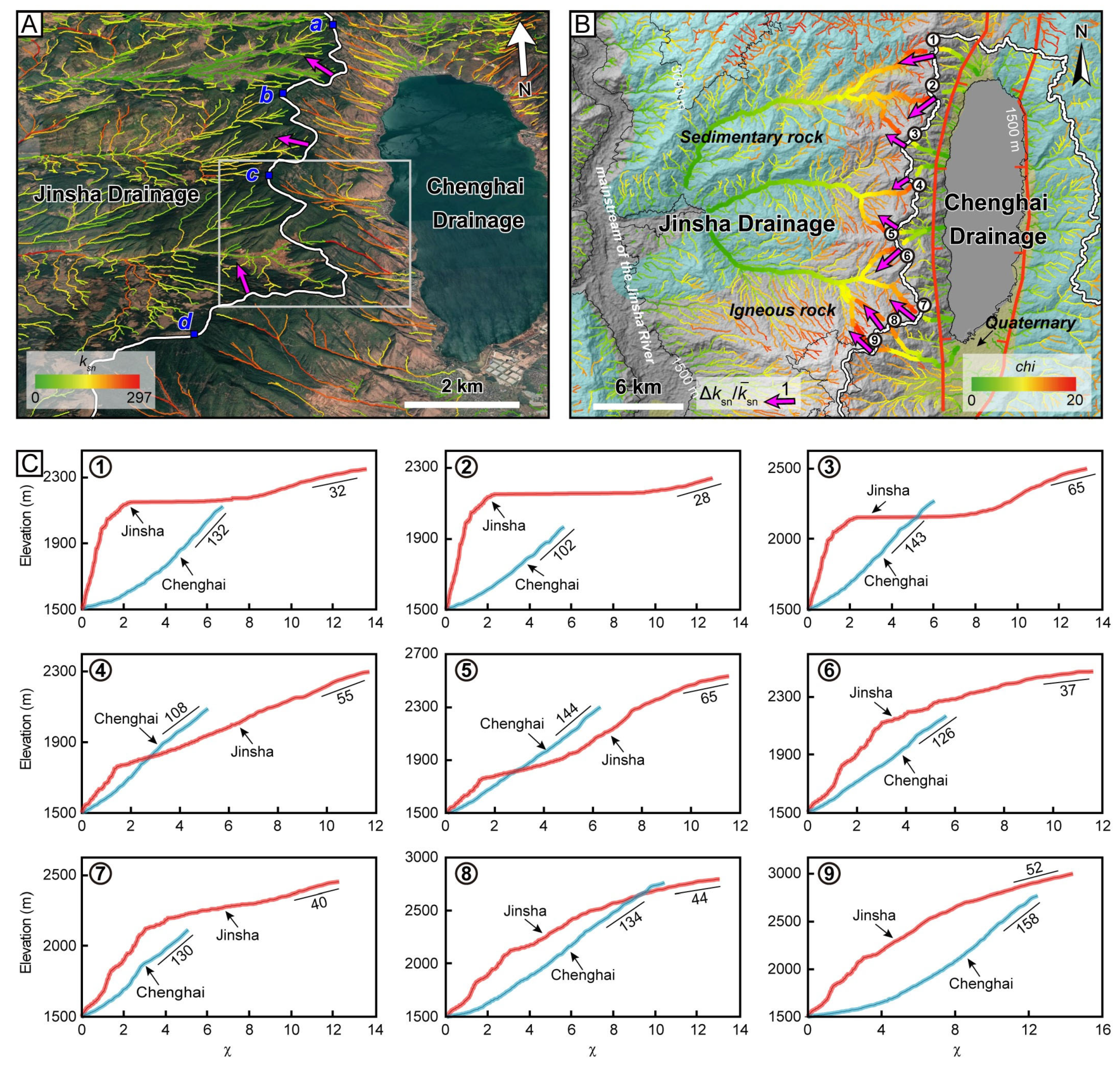
Figure 2. Perspective views and χ map of channels for the Chenghai–Jinsha drainage divide. The location is shown in Figure 1B. (A) Perspective views of channels mapped with ksn. Arrows indicate the migration results based on the Gilbert metrics method. (B) Map of χ and geology. Blue filling represents sedimentary rocks, yellow filling represents Quaternary sediments, and transparent filling represents igneous rocks. Arrows show the divide migration directions and cross-divide difference in normalized ksn. (C) χ-plots for nine paired rivers across the divide. Numbers in the χ-plots are the average ksn values. The results show that the Chenghai–Jinsha drainage divide is moving west.
Remotesensing 16 03471 g002
Here, we first analyze the stability of the Chenghai–Jinsha drainage divide using two methods (χ-plot and Gilbert metrics), and calculate its future stable location. Then we use numerical modeling to reproduce the drainage evolution process in response to the normal faulting and asymmetric uplift, which constrains the initiation time of the Chenghai Fault. This study aims to provide new, independent evidence for the fluvial geomorphic evolution in response to the Chenghai Fault in southeastern Tibetan Plateau.

2. Background

The southeastern margin of the Tibetan Plateau consists mainly of the Burma block, the Indochina block, and the Chuan–Dian block of South China (Figure 1). The Chuan–Dian block is bounded to the north and east by the Xianshuihe–Xiaojiang Fault, separating it from the Bayankhara block and the rest of the South China block, respectively. The South China block, including Chuan–Dian, is separated from the Indochina block by the Red River Fault [10,45], which extends a total length of ~1000 km from the eastern Himalayan syntaxis to the South China Sea. The regional topography is characterized by a high-elevation, low-relief landscape [46,47] and is incised by the Nu, Lancang, and Jinsha Rivers and their tributaries (Figure 1).
The Chenghai Fault in the southwest Chuan–Dian block is one of the active, major faults regulating the intracontinental deformation [17,23,48]. It strikes in a nearly N–S direction, extends for more than 170 km, and terminates at the Red River Fault (Figure 1). The Chenghai Fault has strong seismic activity in the late Quaternary. According to paleoseismic and modern seismological records, it generated eight earthquakes with M ≥ 5 since the 1515 Yongsheng M 73/4 earthquake [20,21,22,23,49]. The 2001 Yongsheng M 6.0 earthquake was the largest earthquake along the Chenghai Fault in the past 200 years [24]. The Chenghai Fault has a composite activity manner of vertical and horizontal left-slip movement [23,49,50,51,52]. Its Quaternary activity has obvious segmentation. One proposed explanation is that the Chenghai Fault is a normal fault, only characterized by sinistral strike–slip movement along the middle segment [49,50,51,52]. However, recent studies have argued that the northern segment of the Chenghai Fault has obvious normal slip movement, while other fault segments are sinistral strike–slip, with small dip–slip components [23]. This study focuses on the northern segment of the Chenghai Fault, where normal faulting prevails in the late Cenozoic. The estimated vertical slip rate ranges from 0.5 to 4 mm/yr in the Quaternary based on geomorphological features and 14C dates [49,50,51,52].
In the northern Chenghai Fault, normal faulting resulted in the subsidence of the Chenghai Basin, and formed a sharp basin–mountain boundary [9,23,48]. The Chenghai–Jinsha drainage divide separates the rivers that flow eastward to the Chenghai Basin from the west-flowing tributaries of the Jinsha River on the west flank (Figure 2). Lithologies in the drainage basins are broadly composed of igneous rock and sedimentary rock formed in the Ordovician to the Quaternary (Figure 2B). Moreover, Pliocene and Early Pleistocene sediments, including lacustrine, fluvial, and pluvial deposits (i.e., the Xigeda Formation or Sanying Formation in this region), are distributed in the Chenghai Basin [51,52].

3. Methods

3.1. Measuring Drainage Divide Stability

Drainage divide migration is essentially driven by the cross-divide difference in erosion rate [32,33,34,35,36]. Therefore, metrics that represents such a contrast, such as the top-most slope of the χ-plot [32,36] and the Gilbert metrics [33], can be used to assess the stability of the drainage divide.
According to the detachment-limited stream power model [53], the channel gradient (S) is expressed as [54]:
S = ( E K ) 1 n A m n
where E is erosion rate, K is erosion coefficient, A is upstream area, m is area exponent, and n is slope exponent [55,56].
The river longitudinal elevation (z) profile is given by integrating upstream ( x ) from the base level ( x b ):
z x = z b + x b x S ( x ) d x
By combining Equations (1) and (2), a transformed river profile can be expressed as the following equations:
z ( x ) = z b + k s n ( A 0 ) m n χ
with
k s n = E K 1 n = S A m n  
and
χ = x b x A 0 A x m n d x
where χ is a spatial integral of the drainage area, ksn is steepness index, and A0 is an arbitrary scaling area [32,57].
The χ-plot depicts the relationship between the river longitudinal elevation (z) and χ. The slope value of the χ-plot is proportional to the ksn if A0 is set to unity (Equation (3)), and the ksn is proportional to the erosion rate if K and n are set to unity (Equation (4)). Therefore, comparing the top-most ksn value (i.e., the slope of the linear or quasi-linear segments of the χ-plots) has been used to measure the drainage divide stability, assuming similar lithology and precipitation [32,33,40,58,59]. A steeper slope of the χ-plot (i.e., higher ksn value) indicates that the drainage divide tends to migrate towards the other side [58,60].
We also adopt the “Gilbert metrics” method [33] to determine the migration direction of divide (Figure 3). This method is proposed based on Gilbert’s (1877) [61] law of unequal declivities. It assumes that divides will migrate from the side with faster erosion towards the slow erosion side. It evaluates three topographic indexes, including headwater elevation, mean hillslope relief, and mean hillslope gradient, which are topographic proxies for erosion rate in close proximity to the drainage divide. A drainage divide would migrate towards the side with a lower slope, lower relief, or higher channel head elevation [33]. Procedures to perform the calculations are implemented in the Topographic Analysis Kit [62] and DivideTools [33] based on TopoToolbox in Matlab program [63].

3.2. Estimation of the Stable Location of Drainage Divides

The future steady location of a drainage divide can be calculated by the steady-state equation of a drainage divide [36]:
C = 0 D β x c U β + x D α + D β U α U β 1 n D β x b m n d x 0 D α x c U α x D α + D β U α U β 1 n D α x b m n d x
with
C = ( K β K α ) 1 n ( H β H α ) ( T β T α ) m b n 1 ( k β k α ) m n
where C index (called the cross-divide contrast index) quantifies the relationship between the erosion coefficient (K), channel height (H), tortuosity coefficient (T), and Hack’s coefficient and exponent (k and b) [36]. D is the horizontal distance from the base level to the divide along the divide normal direction,   x c is the headwater hillslope length, x is the horizontal upstream distance of a channel along the divide normal direction, and subscripts α and β represent the two sides across the divide. In this study, we designate α as the eastern side, and β the western side. We predict the final stable location of the divide based on the relationship between the uplift-rate ratio and normalized drainage divide location at steady state.

3.3. Numerical Modeling of Landscape Evolution

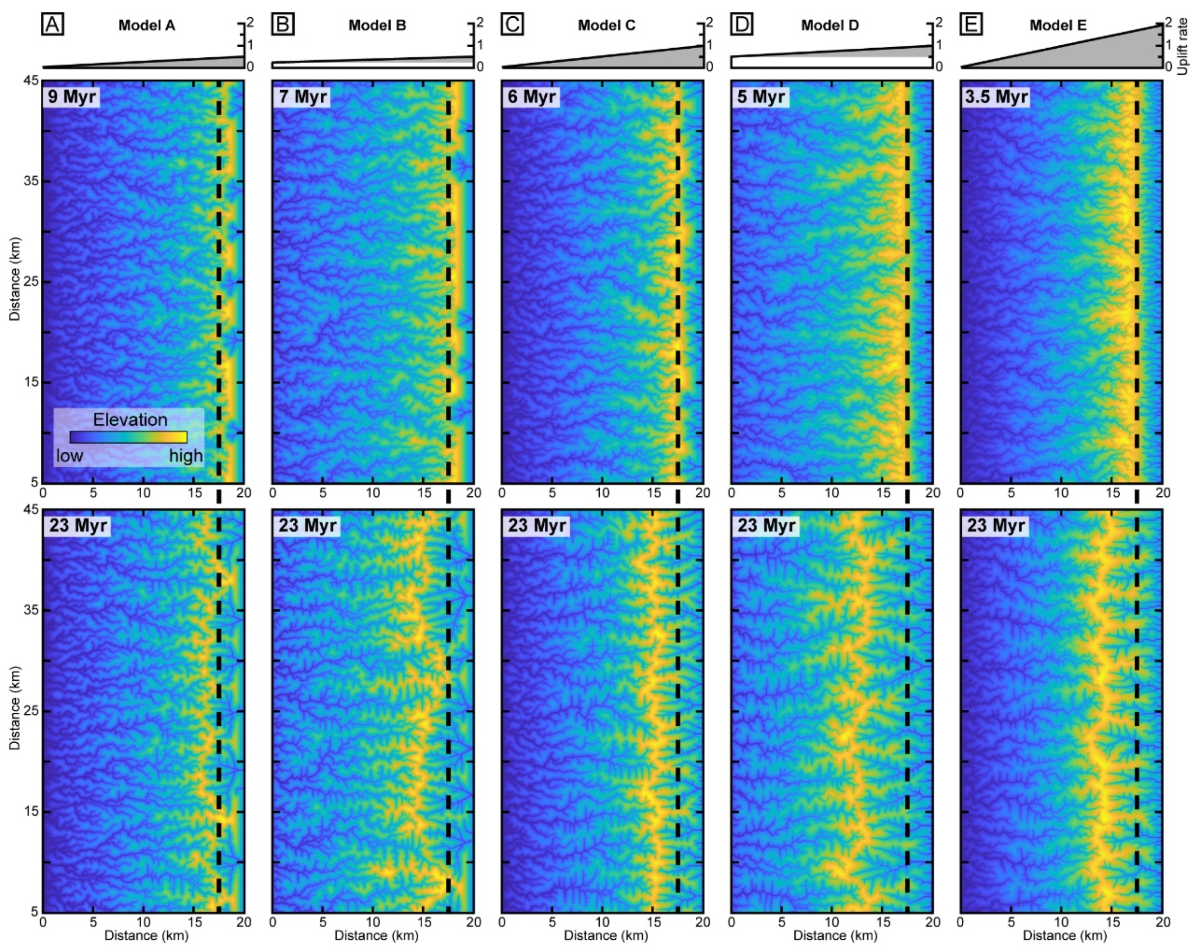
To reproduce the drainage evolution in response to asymmetric uplift, we employ the TopoToolbox Landscape Evolution Model [64], a MATLAB-based landscape evolution model contained in TopoToolbox 2 [63]. It only simulates the process of river incision and hillslope processes without the deposition of materials. The designed model extends 20 km long in the E–W direction and 50 km wide in the N–S direction, with a spatial resolution of 50 m. The length of 20 km corresponds to the distance from the downstream of the Chenghai River to the confluence of the tributary and main stream of the Jinsha River (Figure 2). The initial elevation is set as 100 m along the eastern edge, whereas the elevations at the other edges are fixed to 0 m. In addition, a Gaussian noise of 0–50 m is applied to initiate a random river network. The uplift rate linearly decreases from the eastern to the western edge to model the asymmetric uplift associated with fault activity. We conducted five numerical experiments with different uplift rates and rate ratios (i.e., the ratio of the uplift rates at the western and eastern edges).
Other model parameters are set as follows: erosion coefficient (K), 3 × 10⁻⁶/yr; area exponent (m), 0.5; slope exponent (n), 1; hillslope diffusivity, 0.03 m2/yr; and drainage area threshold, 0.1 km2. These input parameters are guided by values used in similar studies [34,35,41,64,65]. Each model is run for 50 Myr, with a time step of 0.5 Myr.
In this study, we performed a series of numerical models to elucidate the evolution of the Chenghai–Jinsha drainage divide under an asymmetrical uplift. Due to the uncertainty of vertical slip rate (0.5–4 mm/yr [49,50,51], and the unknown uplift rate ratio across the Chenghai Fault, we performed five models with different uplift rates and rate ratios. We kept a constant uplift rate on the western edge (0 mm/yr), and assigned the uplift rate on the eastern edge with 0.5 (Model A), 1 (Model C), and 2 mm/yr (Model E). In addition, Model B and Model D were designed with an uplift rate ratio of 0.5, which were achieved by linearly decreasing the uplift rate from 0.5 and 1 mm/yr on the eastern edge to 0.25 and 0.5 mm/yr on the western edge, respectively.

4. Results

4.1. Stability of the Chenghai–Jinsha Drainage Divide

Because the lithology and precipitation are nearly identical across the Chenghai–Jinsha drainage divide over short distances (several kilometers), the results of χ-plots and Gilbert metrics both reflect the cross-divide difference in erosion rates.
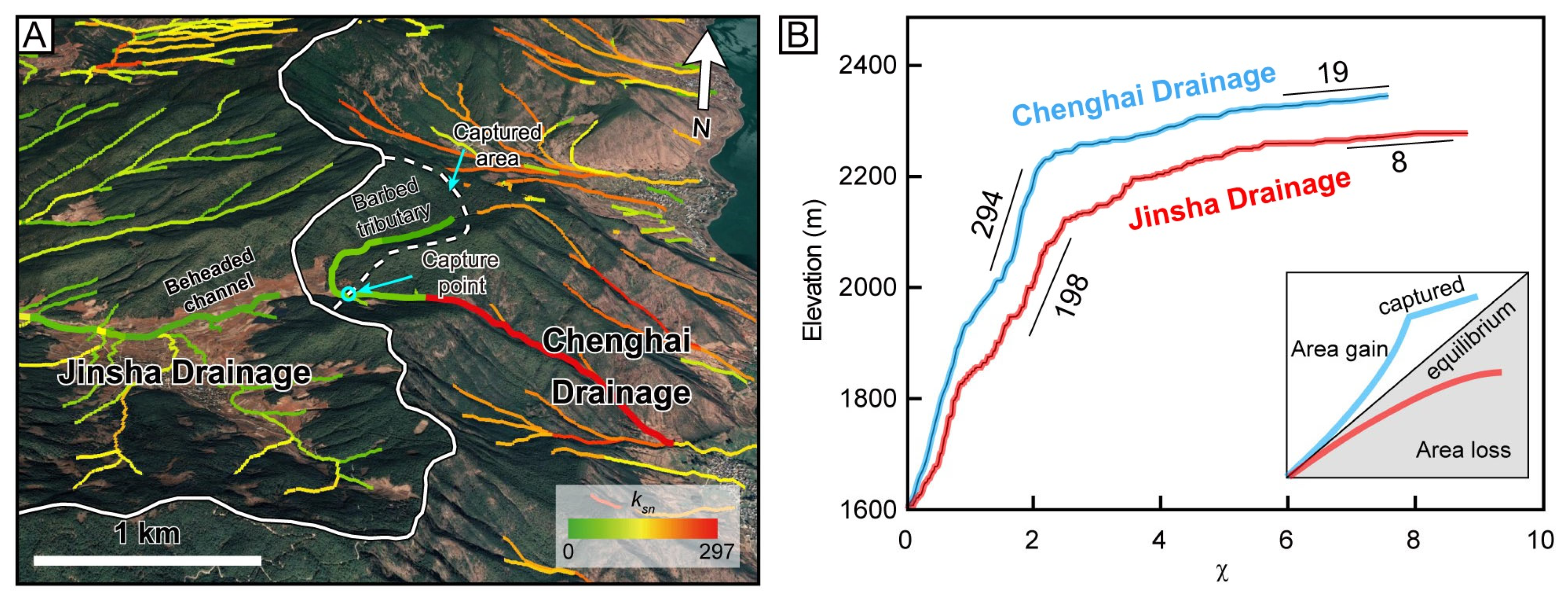
We first conducted a regional comparison of the cross-divide differences in topographic features, ksn, and χ. The satellite imagery and χ map show that the Chenghai Drainage exhibits a steeper topography, higher ksn, and lower χ value than those in the Jinsha Drainage (Figure 2A,B). Then, we selected nine pairs of river channels across the Chenghai–Jinsha drainage divide to create the χ-plots. All the top-most reaches of the Chenghai River have greater slopes of χ-plot (i.e., ksn) than those of the Jinsha River (Figure 2C), which shows that the Chenghai drainage divide is migrating westward. The normalized difference in ksn (i.e., k s n / k s n ¯ ) is shown in Figure 2B. Here, we showed a characteristic example to demonstrate the migration pattern. We identified a tributary to the east of the divide as barbed tributary, as the west-flowing channel turns by approximately 180° and flows into the Chenghai Drainage (Figure 4A). It is a direct diagnostic character for river capture [66,67,68], which means the Chenghai Drainage must have just captured a small area of the headwaters of the Jinsha Drainage. Geometric features of the captured area have not adjusted to the Chenghai Drainage, but are still similar to those in the Jinsha Drainage (Figure 4A). The χ-plot of a river pair close to the capture point also signifies a drainage area gain by river capture (Figure 4B) [32]. Although the Jinsha River and Chenghai River have similar and lower slope (ksn) at the top reaches, the Chenghai River shows a high slope below the top reach. It implies a drainage area gain for the Chenghai River (Figure 4B).
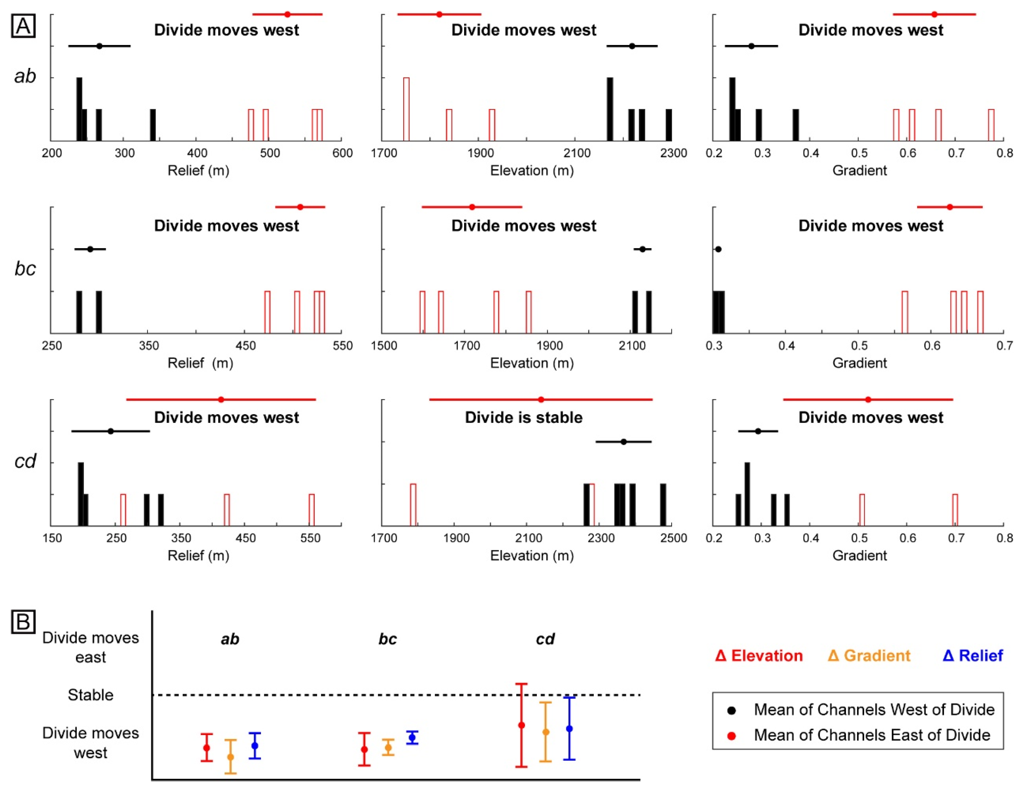
We further adopt Gilbert metrics method to analyze the stability of the Chenghai–Jinsha drainage divide. This drainage divide is divided into three segments (ab, bc, and cd in Figure 2A), mainly based on the morphological features of the drainage basin. In this study, we used a reference drainage area of 105 m2 to calculate the Gilbert metrics. The channel head relief, elevation, and gradient values on either side of a divide were visualized as individual divide sections by histograms, which shows the Chenghai Drainage has a greater relief, lower elevation of the channel, and steeper hillslope gradient than that of the Jinsha Drainage (Figure 5A). Meanwhile, the standardized deviation of those metrics for the sub-segment along the divide reveal a consistent, uniform westward movement of the entire drainage divide (Figure 5B).

4.2. Future Stable Location of the Chenghai–Jinsha Drainage Divide

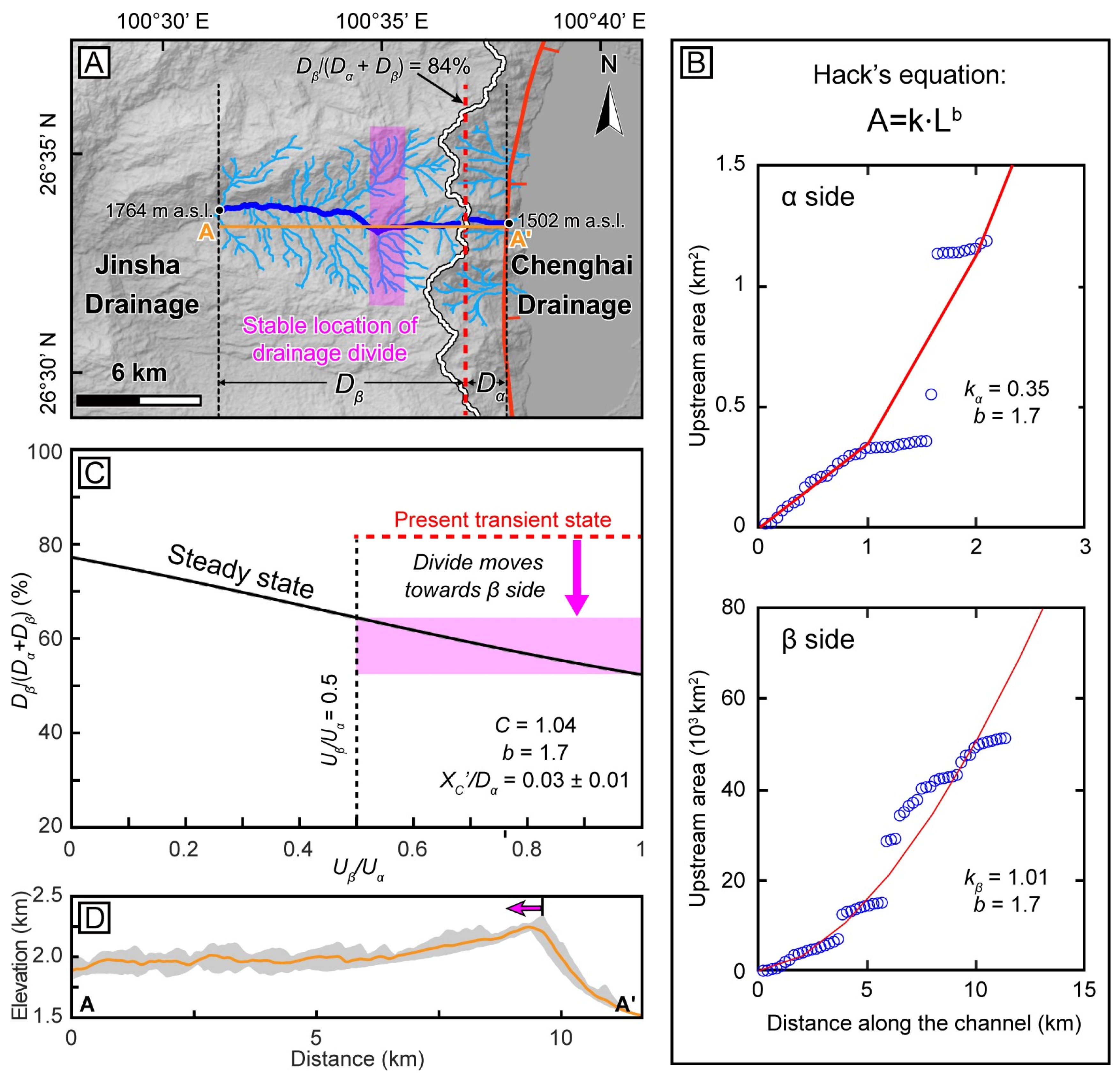
We applied the steady-state equation of drainage divides [36] to predict the future steady location of the Chenghai–Jinsha drainage divide. We selected a pair of representative rivers across the drainage divide flowing separately into the Jinsha and Chenghai Drainage (Figure 6A). Along the river channel in the Jinsha Drainage, a significant knickpoint separates the low channel gradient upstream from the steep downstream (Figure 2C). In addition, the Chenghai Fault cuts the river channel in the Chenghai Drainage. We thus chose the knickpoint and normal fault as the base level of the river channels on the west and east side, respectively. To the first order, we assumed that the lithology between the two base points is uniform, and the uplift rate varies along a linear gradient.
We first measured the elevation difference from the headwater to the base level, where Hα is 708 m and Hβ is 474 m. Then, the channel tortuosity coefficients on the east side (Tα = 1.05) and west side (Tβ = 1.23) were calculated based on the ratio between the horizontal distance along the channel (dxα = 2145 m, dxβ = 11,537 m) and that along the divide normal direction (dx′α =2045 m, dx′β = 9367 m). By fitting the drainage area and channel length, the Hack’s coefficient (kα = 0.35, kβ = 1.01) and exponent (b = 1.7) were determined (Figure 6B) [36,69]. We further calculated the C value (C = 1.04) assuming a uniform erosion coefficient ( K β / K α = 1 ) because of the similar lithology and precipitation across the divide. The parameters are detailed in Table 1. Accordingly, we plotted the relationship diagram between the normalized drainage divide location ( D β     ( D α +   D β ) ) and uplift rate ratio ( U β / U α ) (Figure 6C). Considering a relatively short distance from the selected base level in the Jinsha Drainage to the fault, the uplift rate ratio ( U β / U α ) may fall in a wide range of 0.5–1.0. With that, the normalized drainage divide location ( D β     ( D α +   D β ) ) value was determined as 64%–52%, where the drainage divide attains steady state. Based on the present normalized location of the Chenghai–Jinsha drainage divide (~84%), we predict that the divide will achieve steady state after migrating for ~2.2–3.5 km to the west, given all geological conditions remain unchanged.

4.3. Numerical Modeling on Landscape Evolution

Figure 7 shows selected representative snapshots, which provides an overview of the evolution process. When the asymmetric uplift began, the divides in all models occurred at the eastern edge and started to move westward until reaching a steady state. The detailed evolution process of an example (Model C) is recorded in Supplementary Movie S1. The difference lies in the rate of divide migration. The present Chenghai–Jinsha drainage divide is ~2–3 km away from the Chenghai Fault. To obtain the timescale for the divide to reach its current location, we plotted the position of the divide at each moment and recorded the time (Figure 7). In the cases of an uplift rate ratio of 0, the timescale decreases as the uplift rate on the eastern edge increases. When the uplift rate is 2 mm/yr (Model e), it takes 3.5 Myr for the divide to migrate 2.5 km (a simple average estimate) to the west (Figure 7E). Even at a low uplift rate of 0.5 mm/yr (Model A), this timescale is only 9 Myr (Figure 7A). Moreover, a higher uplift rate ratio accelerates divide migration. For instance, when the uplift rates on the eastern edge remain constant, the timescale of the divide to its current location is shortened in both Model B and Model D (Figure 7B,D), as compared to Model A and Model C (Figure 7A,C), respectively. After 23 Myr of asymmetric uplift, the drainage divide in each model has migrated westward by more than 5 km (Figure 7), which is much greater than the migration distance of the present Chenghai–Jinsha drainage divide.

5. Discussion

5.1. Drainage Reorganization around the Chenghai Fault

Based on a positive, monotonic relationship between the ksn and erosion rate [55], the distribution of ksn indicates an asymmetric uplift pattern around the Chenghai Fault (Figure 2A). The uplift rate (and ksn) is higher east of the divide, and then gradually decreases westward from the fault. Accordingly, the east side of the Chenghai–Jinsha divide has a steeper topography than that in the west side (Figure 6D). Detailed field investigations and 14C dates suggested that the northern segment has the highest vertical slip rate along the Chenghai Fault, which is ~0.6 mm/yr and possibly as high as 4 mm/yr [49,50,51,52]. Meanwhile, the largest earthquake (the 1515 Yongsheng M 73/4 earthquake) in the region occurred the norther segment of the Chenghai Fault. Therefore, the Chenghai Fault results in the regional asymmetric uplift.
Drainage divide stability is fundamentally controlled by tectonics, lithology, and climate [32,34,39,70]. When rock erodibility and precipitation are homogeneous across the divide, tectonic activities will lead to drainage reorganization and divide migration [39,46,71]. In many natural cases where a mountain range undergoes asymmetric uplift, the drainage divide that it hosts migrates towards the side with a high uplift rate [30,32,33,38,40,72]. Nevertheless, the Chenghai–Jinsha drainage divide is migrating away from the high-uplift-rate side and towards the geometric center. This suggests that the initial topography and drainage network before the onset of the Chenghai normal fault should be considered to understand the modern-day geomorphic patterns [41].
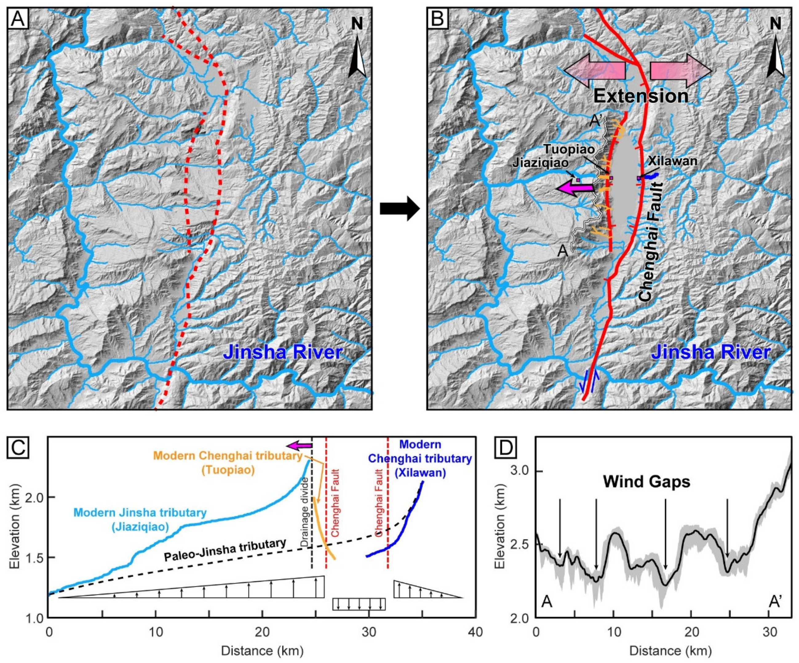
We propose a hypothesis for the drainage reorganization and divide migration associated with the development of the northern Chenghai Fault (Figure 8). Before the initiation of the Chenghai Fault, the topography may be tended gently towards the west, facilitating the development of the west-flowing rivers (Figure 8A). This is supported by several geomorphic features. First, the topography width profile along the drainage divide has revealed multiple wind gaps, which imply the occurrence of river captures (Figure 8D) [41,67]. Also, the satellite imagery and χ-plot show that some west-flowing rivers are being reversed to flow eastward (Figure 4). Furthermore, a wide basin is distributed at the source of the tributary of Jinsha River (i.e., the beheaded river in Figure 4), demonstrating that a river capture event must have occurred here [46,73,74].
Following the initiation of the Chenghai normal faulting, E–W-directed extension resulted in the subsidence of the Chenghai Basin (Figure 8B) [23,48]. The Chenghai Fault is the boundary between the basin and mountain in this region. Due to the normal faulting, the Chenghai–Jinsha drainage divide emerged in the footwall block of the Chenghai Fault, and the topography to the east of the drainage divide was characterized by high relief and steep slope. The Chenghai Basin in the hanging-wall block of the Chenghai Fault has been filled by ~1800 m of sediment since the Neogene [51]. As the river systems evolved, the higher erosion rate on the east side drove the drainage divide to migrate westward and continues to the present (Figure 8B). In the future, the divide will keep migrating westward for ~2.2–3.5 km to reach a steady state, assuming all conditions remain unchanged.

5.2. Implications for the Initiation of the Chenghai Fault

Our newly revealed drainage divide stability and numerical modeling results offer an independent constraint on the tectonic evolution of the Chenghai Fault. The current Chenghai–Jinsha drainage divide has migrated westward by ~2–3 km since the onset of the Chenghai normal faulting (Figure 2A and Figure 6A). Such a short migration distance indicates the young age of the drainage divide. Meanwhile, our numerical modeling results further demonstrate that it took only a few million years for the divide to migrate to the current location (Figure 6). The timescale decreases as the uplift rate on the eastern edge and the uplift radio increase. Even in the case with a low uplift rate of 0.5 mm/yr and uplift rate ratio of 0, the divide migration to ~2.5 km would have taken only 9 Myr. Considering the complex active fault systems in the southeastern Tibetan Plateau and a relatively short distance from the eastern edge, the western edge may also be affected by the vertical uplift, thus resulting in a larger uplift rate ratio (i.e., U β / U α ). This would further shorten the time required for divide migration (Figure 6). In another example, the Xizhou Shan of the Shanxi Rift in North China, the newly emerged main drainage divide has migrated ~3–4 km away from the fault zone over the past ~7 Myr based on the numerical modeling [41]. Moreover, the Chenghai Basin has preserved fluvial–lacustrine facies sedimentary deposits from the Pliocene and Early Pleistocene (i.e., the Xigeda Formation or Sanying Formation in this region), indicating the initiation of the Chenghai Fault during this period [51,52]. Therefore, all these results support that the Chenghai Fault initiated in the Pliocene.
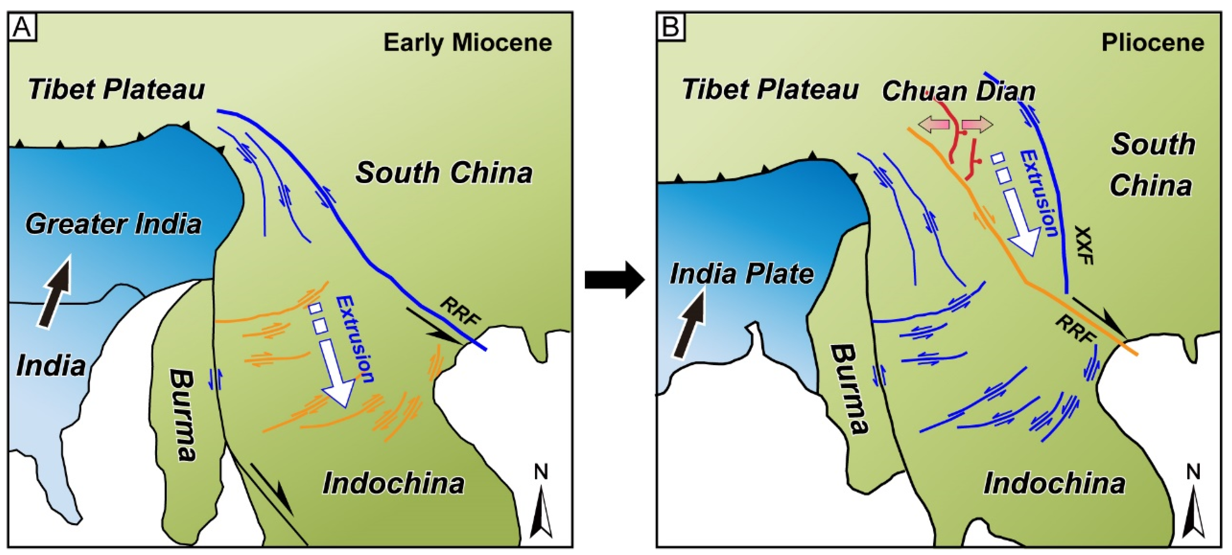
The younger activity of the Chenghai Fault provides new insights into the regional deformation. Affected by the southeastward motion and clockwise rotation of the southeastern margin of the Tibetan Plateau, the fault systems in the southeastern plateau have undergone extensive kinematic reversal [5,9,10,11,12,13] (Figure 9). After the Red River Fault turned into dextral shear, the northern part of the Chuan–Dian block entered the shear-extensional deformation stage (Figure 9). The Chenghai Fault has also initiated extensional deformation, which constitutes the basin–mountain boundary in this region. Right-lateral faulting on the Red River Fault and normal faulting in the northern Chuan–Dian block would be the consequences of the present extrusion phase (Figure 9) [5]. The younger activity of the Chenghai Fault supports a later onset of kinematic reversal along the Red River Fault. As the structural deformation propagates towards the central part of the Chuan–Dian block, the Chenghai Fault is controlled by two boundary faults and exhibits sinistral strike slip movement [23]. Therefore, the Chenghai Fault should be strongly active, and has strong seismic activity in the late Quaternary.

6. Conclusions

We use χ-plot and Gilbert metrics methods to analyze the stability of the Chenghai–Jinsha drainage divide at the northwest Chuan–Dian block. The results show that this divide is migrating westward away from the Chenghai Fault and will further migrate ~2.2–3.5 km westward to reach a steady state, given all geological conditions remain unchanged. The migration of the Chenghai–Jinsha drainage divide is driven by the initiation of the normal faulting along the Chenghai Fault. Normal faulting controls the subsidence of the Chenghai Basin, causing the west-flowing rivers to reverse their flow towards the Chenghai Basin. The Chenghai–Jinsha drainage divide first occurred at the eastern edge and migrated towards the geometric center. Our numerical modeling results suggest that it took a few million years for the Chenghai–Jinsha drainage divide to migrate to its current location. It implies that the Chenghai Fault initiated in the Pliocene.

Supplementary Materials

The following supporting information can be downloaded at: https://www.mdpi.com/article/10.3390/rs16183471/s1, Movie S1: Numerical landscape evolution simulation.

Author Contributions

S.B.: methodology; data processing; writing—original draft; review and editing of the final manuscript. X.T.: conceptualization; methodology; field investigation; writing—original draft; review and editing of the final manuscript. Y.L.: writing—original draft; review and editing of the final manuscript. F.S.: methodology; writing—original draft; review and editing of the final manuscript. J.G.: writing—original draft; review and editing of the final manuscript. All authors have read and agreed to the published version of the manuscript.

Funding

This study is supported by the National Key Research and Development Program of China (No. 2021YFC3000601), National Natural Science Foundation of China (No. 42202249), and CAS Pioneer Hundred Talents Program (No. E2K2010010).

Data Availability Statement

The topography data (ALOS digital elevation models) were obtained from the Alaska Satellite Facility Data Search (https://search.asf.alaska.edu/, 1 June 2023). The χ-plots are implemented through the Topographic Analysis Kit [62] based on TopoToolbox [63]. The landscape evolution modeling was conducted using the TopoToolbox Landscape Evolution Model [64].

Conflicts of Interest

The authors declare no conflicts of interest.

References

  1. Molnar, P.; Tapponnier, P. Cenozoic Tectonics of Asia: Effects of a Continental Collision: Features of recent continental tectonics in Asia can be interpreted as results of the India-Eurasia collision. Science 1975, 189, 419–426. [Google Scholar] [CrossRef] [PubMed]
  2. Tapponnier, P.; Molnar, P. Active faulting and tectonics in China. J. Geophys. Res. 1977, 82, 2905–2930. [Google Scholar] [CrossRef]
  3. Yin, A.; Harrison, T.M. Geologic evolution of the Himalayan-Tibetan orogen. Annu. Rev. Earth Planet. Sci. 2000, 28, 211–280. [Google Scholar] [CrossRef]
  4. Tapponnier, P.; Xu, Z.Q.; Roger, F.; Meyer, B.; Arnaud, N.; Wittlinger, G.; Yang, J.S. Oblique stepwise rise and growth of the Tibet Plateau. Science 2001, 294, 1671–1677. [Google Scholar] [CrossRef]
  5. Tapponnier, P.; Peltzer, G.; Le Dain, A.Y.; Armijo, R.; Cobbold, P. Propagating extrusion tectonics in Asia: New insights from simple experiments with plasticine. Geology 1982, 10, 611–616. [Google Scholar] [CrossRef]
  6. Molnar, P.; England, P.; Martinod, J. Mantle dynamics, uplift of the Tibetan Plateau, and the Indian monsoon. Rev. Geophys. 1993, 31, 357–396. [Google Scholar] [CrossRef]
  7. Royden, L.H.; Burchfiel, B.C.; van der Hilst, R.D. The geological evolution of the Tibetan Plateau. Science 2008, 321, 1054–1058. [Google Scholar] [CrossRef]
  8. Royden, L.H.; Burchfiel, B.C.; King, R.W.; Wang, E.; Chen, Z.; Shen, F.; Liu, Y. Surface deformation and lower crustal flow in eastern Tibet. Science 1997, 276, 788–790. [Google Scholar] [CrossRef]
  9. Wang, E.; Burchfiel, B.C.; Royden, L.H.; Chen, L.Z.; Chen, J.S.; Li, W.X.; Chen, Z.L. Late Cenozoic Xianshuihe-Xiaojiang, Red River, and Dali Fault Systems of Southwestern Sichuan and Central Yunnan, China; Geological Society of America Special Paper; Geological Society of America: Boulder, CO, USA, 1998; Volume 327. [Google Scholar]
  10. Leloup, P.H.; Arnaud, N.; Lacassin, R.; Kienast, J.R.; Harrison, T.M.; Trong, T.P.; Replumaz, A.; Tapponnier, P. New constraints on the structure, thermochronology, and timing of the Ailao Shan-Red River shear zone, SE Asia. J. Geophys. Res. Solid Earth 2001, 106, 6683–6732. [Google Scholar] [CrossRef]
  11. Xu, X.W.; Cheng, G.L.; Yu, G.H.; Song, F.M.; Xiang, H.F.; Zhang, L.F.; Ron, H.; Wang, Y.L.; Wen, X.Z. Tectonic and paleomagnetic evidence for the clockwise rotation of the Sichuan-Yunnan rhombic block. Seismol. Geol. 2003, 25, 61–70, (In Chinese with English abstract). [Google Scholar]
  12. Li, S.H.; Advokaat, E.L.; van Hinsbergen, D.J.; Koymans, M.; Deng, C.; Zhu, R. Paleomagnetic constraints on the Mesozoic-Cenozoic paleolatitudinal and rotational history of Indochina and South China: Review and updated kinematic reconstruction. Earth-Sci. Rev. 2017, 171, 58–77. [Google Scholar] [CrossRef]
  13. Wang, Y.; Wang, Y.J.; Zhang, P.Z.; Zhang, J.J.; Zhang, B.; Jing, L.-Z.; Zhou, R.J.; Wang, W.T.; Zhang, H.P.; Li, Z.J. Cenozoic tectonic evolution of regional fault systems in the SE Tibetan Plateau. Sci. China Earth Sci. 2022, 65, 601–623. [Google Scholar] [CrossRef]
  14. Wang, Y.; Wang, Y.; Schoenbohm, L.M.; Zhang, P.; Zhang, B.; Sobel, E.R.; Zhou, R.J.; Shi, X.H.; Zhang, J.J.; Stockli, D.F.; et al. Cenozoic exhumation of the Ailaoshan-Red River shear zone: New insights from low-temperature thermochronology. Tectonics 2020, 39, e2020TC006151. [Google Scholar] [CrossRef]
  15. Leloup, P.H.; Harrison, T.M.; Ryerson, F.J.; Cheng, W.J.; Li, Q.; Tapponnier, P.; Lacassin, R. Structural, petrological and thermal evolution of a Tertiary ductile strike-slip shear zone, Diancang Shan, Yunnan. J. Geophys. Res. Solid Earth 1993, 98, 6715–6743. [Google Scholar] [CrossRef]
  16. Cao, S.Y.; Neubauer, F.; Liu, J.L.; Genser, J.; Leiss, B. Exhumation of the Diancang Shan metamorphic complex along the Ailao Shan-Red River belt, southwestern Yunnan, China: Evidence from 40Ar/39Ar thermochronology. J. Asian Earth Sci. 2011, 42, 525–550. [Google Scholar] [CrossRef]
  17. Li, S.H.; Deng, C.L.; Yao, H.T.; Huang, S.; Liu, C.Y.; He, H.Y.; Pan, Y.X.; Zhu, R.X. Magnetostratigraphy of the Dali Basin in Yunnan and implications for late Neogene rotation of the southeast margin of the Tibetan Plateau. J. Geophys. Res. Solid Earth 2013, 118, 791–807. [Google Scholar] [CrossRef]
  18. England, P.; Molnar, P. Surface uplift, uplift of rocks, and exhumation of rocks. Geology 1990, 18, 1173–1177. [Google Scholar] [CrossRef]
  19. Copley, A. Kinematics and dynamics of the southeastern margin of the Tibetan Plateau. Geophys. J. Int. 2008, 174, 1081–1100. [Google Scholar] [CrossRef]
  20. Department of Earthquake Disaster Prevention, China Earthquake Administration (DEDP). Catalogue of Strong Earthquakes in Chinese History: 23rd Century BC–1911 AD; Seismological Press: Beijing, China, 1995. [Google Scholar]
  21. Wang, B.; Wu, G.; Su, Y.; Wang, B.; Ge, H.; Jin, M. Site construction of the Binchuan transmitting seismic stations and preliminary observational data. J. Seismol. Res. 2015, 38, 1–6. [Google Scholar]
  22. Zhou, Q.; Guo, S.; Xiang, H. Principle and method of delineation of potential seismic sources in northeastern Yunnan province. Seismol. Geol. 2004, 26, 761–771. [Google Scholar]
  23. Ji, H.; Ren, Z.; Zhu, X.; Bai, M.; Bao, G.; Liu, J.; Ha, G.; He, Z. Slip distribution along the Chenghai fault from airborne LiDAR and tectonic implications for the 1515 Yongsheng earthquake, China. Tectonics 2024, 43, e2024TC008285. [Google Scholar] [CrossRef]
  24. U.S. Geological Survey, Earthquake Hazards Program (USGSEHP). Advanced National Seismic System (ANSS) Comprehensive Catalog of Earthquake Events and Products: Various; U.S. Geological Survey: Reston, VA, USA, 2017. [CrossRef]
  25. Guo, L.; He, Z.; Li, L. Responses of Stream Geomorphic Indices to Piedmont Fault Activity in the Northern Segment of the Red River Fault Zone. Remote Sens. 2023, 15, 988. [Google Scholar] [CrossRef]
  26. Gao, M.; Hao, M.; Zeilinger, G.; Xu, X. Recent Uplift Characteristics of the Southeast Tibetan Plateau, an Analysis Based on Fluvial Indices. Remote Sens. 2023, 15, 433. [Google Scholar] [CrossRef]
  27. Liu, Z.; Zhou, S.; Yu, H.; Zhang, W.; Guo, F.; Chen, X.; Guo, J. Quantitative Analysis of Tectonic Geomorphology Research Based on Web of Science from 1981 to 2021. Remote Sens. 2022, 14, 5227. [Google Scholar] [CrossRef]
  28. Ren, Z.; Zhang, P.; Oguchi, T.; He, Z. Remote Sensing Perspectives on Geomorphology and Tectonic Processes. Remote Sens. 2023, 15, 2327. [Google Scholar] [CrossRef]
  29. Shen, K.; Dong, S.; Wang, Y. Active Tectonics Assessment Using Geomorphic and Drainage Indices in the Sertengshan, Hetao Basin, China. Remote Sens. 2023, 15, 3230. [Google Scholar] [CrossRef]
  30. Sakashita, A.; Endo, N. Mobility and Location of Drainage Divides Affected by Tilting Uplift in Sado Island, Japan. Remote Sens. 2023, 15, 729. [Google Scholar] [CrossRef]
  31. Wang, W.; Shao, Y.; Zhang, J.; Wang, W.; Lu, R. Channel Profiles Reveal Fault Activity along the Longmen Shan, Eastern Tibetan Plateau. Remote Sens. 2023, 15, 4721. [Google Scholar] [CrossRef]
  32. Willett, S.D.; McCoy, S.W.; Perron, J.T.; Goren, L.; Chen, C.Y. Dynamic reorganization of river basins. Science 2014, 343, 1248765. [Google Scholar] [CrossRef]
  33. Forte, A.M.; Whipple, K.X. Criteria and tools for determining drainage divide stability. Earth Planet. Sci. Lett. 2018, 493, 102–117. [Google Scholar] [CrossRef]
  34. He, C.Q.; Yang, C.J.; Turowski, J.M.; Rao, G.; Roda-Boluda, D.C.; Yuan, X.P. Constraining tectonic uplift and advection from the main drainage divide of a mountain belt. Nat. Commun. 2021, 12, 544. [Google Scholar] [CrossRef] [PubMed]
  35. Shi, F.; Tan, X.; Zhou, C.; Liu, Y. Impact of asymmetric uplift on mountain asymmetry: Analytical solution, numerical modeling, and natural examples. Geomorphology 2021, 389, 107862. [Google Scholar] [CrossRef]
  36. Zhou, C.; Tan, X.; Liu, Y.; Shi, F. A cross-divide contrast index (C) for assessing controls on the main drainage divide stability of a mountain belt. Geomorphology 2022, 398, 108071. [Google Scholar] [CrossRef]
  37. Buscher, J.T.; Ascione, A.; Valente, E. Decoding the role of tectonics, incision and lithology on drainage divide migration in the Mt. Alpi region, southern Apennines, Italy. Geomorphology 2017, 276, 37–50. [Google Scholar] [CrossRef]
  38. He, C.; Rao, G.; Yang, R.; Hu, J.; Yao, Q.; Yang, C.J. Divide migration in response to asymmetric uplift: Insights from the Wula Shan horst, North China. Geomorphology 2019, 339, 44–57. [Google Scholar] [CrossRef]
  39. Yang, R.; Suhail, H.A.; Gourbet, L.; Willett, S.D.; Fellin, M.G.; Lin, X.B.; Gong, J.F.; Wei, X.C.; Maden, C.; Jiao, R.H.; et al. Early Pleistocene drainage pattern changes in Eastern Tibet: Constraints from provenance analysis, thermochronometry, and numerical modeling. Earth Planet. Sci. Lett. 2020, 531, 115955. [Google Scholar] [CrossRef]
  40. Chen, C.; Willett, S.D.; Christl, M.; Shyu, J.B.H. Drainage basin dynamics during the transition from early to mature orogeny in Southern Taiwan. Earth Planet. Sci. Lett. 2021, 562, 116874. [Google Scholar] [CrossRef]
  41. Ye, Y.J.; Tan, X.B.; Zhou, C. Initial topography matters in drainage divide migration analysis: Insights from numerical simulations and natural examples. Geomorphology 2022, 409, 108266. [Google Scholar] [CrossRef]
  42. Bian, S.; Tan, X.; Liu, Y.; Fan, S.; Gong, J.; Zhou, C.; Shi, F.; Murphy, M.A. Orographic rainfall drives the Himalaya drainage divide to move north. Geomorphology 2024, 444, 108952. [Google Scholar] [CrossRef]
  43. Ye, Y.J.; Tan, X.B.; Liu, Y.D.; Bian, S.; Zhou, C.; Zeng, X.; Shi, F.; Gao, M.X. Drainage reorganization and divide migration driven by basin subsidence: An example from the Micang Shan, outskirts of eastern Tibet and its implications for Cenozoic evolution of the Yangtze River. Basin Res. 2024, 36, e12875. [Google Scholar] [CrossRef]
  44. Taylor, M.; Yin, A. Active structures of the Himalayan-Tibetan orogen and their relationships to earthquake distribution, contemporary strain field, and Cenozoic volcanism. Geosphere 2009, 5, 199–214. [Google Scholar] [CrossRef]
  45. Tapponnier, P.; Lacassin, R.; Leloup, P.H.; Schärer, U.; Zhong, D.L.; Wu, H.W.; Liu, X.H.; Ji, S.C.; Zhang, L.S.; Zhong, J.Y. The Ailao Shan/Red River metamorphic belt: Tertiary left-lateral shear between Indochina and South China. Nature 1990, 343, 431–437. [Google Scholar] [CrossRef]
  46. Clark, M.; Schoenbohm, L.M.; Royden, L.H.; Whipple, K.X.; Burchfiel, B.C.; Zhang, X.; Tang, W.; Wang, E.; Chen, L. Surface uplift, tectonics, and erosion of eastern Tibet from large-scale drainage patterns. Tectonics 2004, 23, TC1006. [Google Scholar] [CrossRef]
  47. Yang, R.; Willett, S.D.; Goren, L. In situ low-relief landscape formation as a result of river network disruption. Nature 2015, 520, 526–529. [Google Scholar] [CrossRef] [PubMed]
  48. Fan, C.; Wang, G.; Wang, S.F.; Wang, E. Structural interpretation of extensional deformation along the Dali fault system, southeastern margin of the Tibetan Plateau. Int. Geol. Rev. 2006, 48, 287–310. [Google Scholar] [CrossRef]
  49. Luo, R.; Wu, Z.; Huang, X.; Huang, X.; Zhou, C.; Tian, T. The main active faults and the active tectonic system of Binchuan area, northwestern Yunnan. Geol. Bull. China 2015, 34, 155–170. [Google Scholar]
  50. Li, G.R.; Jin, D.S. Neoid Activity on the Chenghai Fracture. Yunnan Geol. 1990, 9, 1–24, (In Chinese with English abstract). [Google Scholar]
  51. Huang, X.J.; Wu, Z.H.; Huang, X.L.; Luo, R.J. Tectonic Geomorphology Constrains on the Quaternary Activity and Segmentation along Chenghai-Binchuan Fault Zone in Northwest Yunnan, China. Earth Sci. 2018, 43, 4651–4670, (In Chinese with English abstract). [Google Scholar]
  52. Huang, X.L.; Wu, Z.H.; Liu, F.; Tian, T.T.; Huang, X.J.; Zhang, D. Tectonic interpretation of the main paleoseismic landslides and their distribution characteristics in the Chenghai fault zone, Northwest Yunnan. Earth Sci. Front. 2021, 28, 125–139, (In Chinese with English abstract). [Google Scholar]
  53. Howard, A.D.; Kerby, G. Channel changes in badlands. Geol. Soc. Am. Bull. 1983, 94, 739–752. [Google Scholar] [CrossRef]
  54. Kirby, E.; Whipple, K.X. Quantifying differential rock-uplift rates via stream profile analysis. Geology 2001, 29, 415–418. [Google Scholar] [CrossRef]
  55. Kirby, E.; Whipple, K.X. Expression of active tectonics in erosional landscapes. J. Struct. Geol. 2012, 44, 54–75. [Google Scholar] [CrossRef]
  56. Whipple, K.X.; Tucker, G.E. Dynamics of the stream-power river incision model: Implications for height limits of mountain ranges, landscape response timescales, and research needs. J. Geophys. Res. Solid Earth 1999, 104, 17661–17674. [Google Scholar] [CrossRef]
  57. Perron, J.T.; Royden, L. An integral approach to bedrock river profile analysis. Earth Surf. Process. Landf. 2013, 38, 570–576. [Google Scholar] [CrossRef]
  58. Zhou, C.; Tan, X.; Liu, Y.; Lu, R.; Murphy, M.A.; He, H.; Han, Z.; Xu, X. Ongoing westward migration of drainage divides in eastern Tibet, quantified from topographic analysis. Geomorphology 2022, 402, 108123. [Google Scholar] [CrossRef]
  59. Ye, Y.J.; Tan, X.B.; Zhou, C.; Bian, S.; Liu, Y.D.; Shi, F. Cross-divide difference of steady-state channel-head elevation controls drainage-divide migration. Earth Surf. Process. Landf. 2024, 1–12. [Google Scholar] [CrossRef]
  60. Zhou, C.; Tan, X.; Liu, Y.; Shi, F. Quantifying the migration rate of drainage divides from high-resolution topographic data. Earth Surf. Dyn. 2024, 12, 433–448. [Google Scholar] [CrossRef]
  61. Gilbert, G.K. Geology of the Henry Mountains; USGS Report; Government Printing Office: Washington, DC, USA, 1877.
  62. Forte, A.M.; Whipple, K.X. Short communication: The Topographic Analysis Kit (TAK) for TopoToolbox. Earth Surf. Dyn. 2019, 7, 87–95. [Google Scholar] [CrossRef]
  63. Schwanghart, W.; Scherler, D. TopoToolbox 2–MATLAB-based software for topographic analysis and modeling in Earth surface sciences. Earth Surf. Dyn. 2014, 2, 1–7. [Google Scholar] [CrossRef]
  64. Campforts, B.; Schwanghart, W.; Govers, G. Accurate simulation of transient landscape evolution by eliminating numerical diffusion: The TTLEM 1.0 model. Earth Surf. Dyn. 2017, 5, 47–66. [Google Scholar] [CrossRef]
  65. Sassolas-Serrayet, T.; Cattin, R.; Ferry, M.; Godard, V.; Simoes, M. Estimating the disequilibrium in denudation rates due to divide migration at the scale of river basins. Earth Surf. Dyn. 2019, 7, 1041–1057. [Google Scholar] [CrossRef]
  66. Bishop, P. Drainage rearrangement by river capture, beheading and diversion. Prog. Phys. Geogr. 1995, 19, 449–473. [Google Scholar] [CrossRef]
  67. Harel, E.; Goren, L.; Shelef, E.; Ginat, H. Drainage reversal toward cliffs induced by lateral lithologic differences. Geology 2019, 47, 928–932. [Google Scholar] [CrossRef]
  68. Shelef, E.; Goren, L. The rate and extent of wind-gap migration regulated by tributary confluences and avulsions. Earth Surf. Dyn. 2021, 9, 687–700. [Google Scholar] [CrossRef]
  69. Hack, J.T. Studies of Longitudinal Stream Profiles in Virginia and Maryland; U.S. Geological Survey Professional Paper; U.S. Government Printing Office: Washington, DC, USA, 1957; pp. 45–97.
  70. Whipple, K.X. Fluvial landscape response time: How plausible is steady-state denudation? Am. J. Sci. 2001, 301, 313–325. [Google Scholar] [CrossRef]
  71. Authemayou, C.; Brocard, G.; Delcaillau, B.; Molliex, S.; Pedoja, K.; Husson, L.; Aribowo, S.; Cahyarini, S.Y. Unraveling the roles of asymmetric uplift, normal faulting and groundwater flow to drainage rearrangement in an emerging karstic landscape. Earth Surf. Process. Landf. 2018, 43, 1885–1898. [Google Scholar] [CrossRef]
  72. Su, Q.; Wang, X.; Lu, H.; Xie, H. Dynamic divide migration as a response to asymmetric uplift: An example from the Zhongtiao Shan, North China. Remote Sens. 2020, 12, 4188. [Google Scholar] [CrossRef]
  73. Whipple, K.X.; DiBiase, R.A.; Ouimet, W.B.; Forte, A.M. Preservation or piracy: Diagnosing low-relief, high-elevation surface formation mechanisms. Geology 2017, 45, 91–94. [Google Scholar] [CrossRef]
  74. Zeng, X.; Tan, X.B. Drainage divide migration in response to strike-slip faulting: An example from northern Longmen Shan, eastern Tibet. Tectonophysics 2023, 848, 229720. [Google Scholar] [CrossRef]
Figure 3. (A) Schematic of Gilbert’s (1877) [61] ‘Law of Unequal Declivities’. (B) Reference drainage area used in all metrics for calculating across divide differences (compiled from [33]).
Remotesensing 16 03471 g003
Figure 4. (A) Perspective views for a captured river on the Chenghai–Jinsha drainage divide. The Chenghai Drainage has just captured the headwaters of the Jinsha Drainage. The location is showed in the white box of the Figure 2A. (B) χ-plots for the beheaded and captured channels. They are highlighted as bold lines in (A).
Remotesensing 16 03471 g004
Figure 5. Divide stability analysis of the Chenghai–Jinsha drainage divide using the Gilbert metrics method [33]. (A) Divide metric histograms for segments ab, bc, and cd. Histograms with black and red rectangles represent watersheds on the western and eastern side of the drainage divide, respectively. (B) Standardized delta plot for the sub-segment of the Chenghai–Jinsha drainage divide. Bars show the standard deviation at 1σ level. Locations of the letters a–d are shown in Figure 2A.
Remotesensing 16 03471 g005
Figure 6. Prediction for the steady-state location of the Chenghai–Jinsha drainage divide. (A) Topography and drainage system. River segments highlighted in dark blue are measured and analyzed. The pink area is the predicted steady-state location. (B) The Hack’s coefficient and exponent (k and b). (C) The relationship diagram between the normalized drainage divide location ( D β ( D α + D β ) ) and uplift rate ratio (Uβ/Uα). (D) Swath profile A–A′ of topography across the divide. Location of the swath is marked by the yellow line in panel (A). The red arrow represents the direction of drainage divide migration.
Remotesensing 16 03471 g006
Figure 7. Topographic maps of divide migration in response to different asymmetric uplift patterns. The top illustrations show the setting of uplift rate. All the models show it will only take several million years for the divide to migrate for ~2.5 km (the location of the vertical dashed lines). The timescale decreases as the uplift rate on the eastern edge and the uplift radio increase. When each model was run for 23 Myr, the divide migration distances are greater than 5 km.
Remotesensing 16 03471 g007
Figure 8. Diagrams of the evolution process of the Chenghai–Jinsha drainage divide. (A) Before the activity of the Chenghai Fault, we inferred that the rivers flowed westward to the Jinsha Drainage. (B) When the normal faulting began, the Chenghai–Jinsha drainage divide first occurred at the eastern edge and migrated westward until reaching a steady state. (C) Schematic of the post-capture profile incision. The modern river profiles are extracted based on DEM, while paleo river profile is speculated. The red arrow represents the direction of drainage divide migration. (D) Elevation profile along the drainage divide (A–A′). The arrows indicate the locations of wind gaps.
Remotesensing 16 03471 g008
Figure 9. Tectonic evolution of the southeastern Tibetan Plateau (modified after [13]). (A) Affected by the continuous northward indentation of the Indian Plate, the southeastern Tibetan Plateau experienced large-scale lateral extrusion and the Red River Fault synchronously initiated sinistral shearing motion. (B) Fault systems have undergone extensive kinematic reversal. Right-lateral faulting on the Red River Fault and normal faulting in the northern Chuan–Dian block may be the consequences of the present extrusion phase.
Remotesensing 16 03471 g009
Table 1. The parameters of typical rivers across the Chenghai–Jinsha drainage divide used for calculating the future stable location. It should be noted that all the parameters are from present topography, which may different from those in the final steady state.
Hα
(m)
Hβ
(m)
xα
(m)
xβ
(m)
D α x c ( m ) D β x c ( m ) TαTβkαkβbC
708474214511,537204593671.051.230.351.011.71.04
Disclaimer/Publisher’s Note: The statements, opinions and data contained in all publications are solely those of the individual author(s) and contributor(s) and not of MDPI and/or the editor(s). MDPI and/or the editor(s) disclaim responsibility for any injury to people or property resulting from any ideas, methods, instructions or products referred to in the content.