Research on Monitoring the Speed of Glacier Terminus Movement Based on the Time-Series Interferometry of a Ground-Based Radar System
Abstract
1. Introduction
2. Materials and Methods
2.1. Study Area
2.2. Monitoring of Glacier Termini Movement Speed from GB Radar
2.2.1. GB Radar System and Parameters
2.2.2. Principle of Radar Time-Series Interferometry Measurement
- 1.
- Signal model
- 2.
- Time-series interferometry measurement
- 3.
- Linear least squares fitting
2.3. Monitoring of Glacier Termini Movement Speed from Sentinel-1
2.4. Glacier Boundary Data
3. Results
4. Discussion
4.1. Heterogeneity of Glaciers
4.2. Environment
4.3. Debris
4.4. Atmosphere
4.5. Radar Line of Sight (RLOS)
4.6. Ku Band
4.7. Fitting Model
5. Conclusions
Author Contributions
Funding
Data Availability Statement
Acknowledgments
Conflicts of Interest
References
- Huang, G.L. Dynamic Variation Characteristics of Glacier in Bomi-Tongmai Section of Parlung Zangbo Basin. Railway Standard Design 2023, 1–10. [Google Scholar] [CrossRef]
- Tian, Y.Y.; Jiang, L.; Guo, J. Numericalsi mulation of glacier avalanche-river blocking-outburst in Sedongpu gully of the Yarlung Zangbo River. J. Geol. 2023, 47, 196–202. [Google Scholar] [CrossRef]
- Wang, S.Z. Estimation of Glacier Velocity over Tibetan Plateau. Master’s Thesis, Nanjing University, Nanjing, China, 2019. [Google Scholar]
- Bai, J.H. Multi-Model Analysis of Permafrost Changes in the Qinghai-Tibet Plateau and Its Hydrological Effects. Master’s Thesis, China University of Geosciences, Beijing, China, 2021. [Google Scholar]
- Luo, H. Impacts of Qinghai Tibet Plateau On Climate Change. Qinghai Sci. Technol. 2015, 3, 46–48. [Google Scholar]
- Ren, X.K.; Gao, J.; Yang, Y.L.; Chen, M.L.; Niu, X.W.; Zhao, A.B. Intra-seasonal characteristics of atmospheric water vapor stable isotopes at Muztagata and its climate controls. J. Glaciol. Geocryol. 2021, 43, 331–341. [Google Scholar] [CrossRef]
- Yao, T.D.; Piao, S.L.; Shen, M.G.; Gao, J.; Yang, W.; Zhang, G.Q.; Lei, Y.B.; Gao, Y.; Zhu, L.P.; Xu, B.Q.; et al. Chained Impacts on Modern Environment of Interaction between Westerlies and Indian Monsoon on Tibetan Plateau. Bull. Chin. Acad. Sci. 2017, 32, 976–984. [Google Scholar] [CrossRef]
- Chen, Y.H.; Tian, L.D.; Zong, J.B.; Zhu, D.Y.; Wang, C.; Jin, S.Q. Variation of the Large and Small Anglong Glaricers in the Ngari Prefecture, Tibet, China. J. Glaciol. Geocryol. 2021, 43, 14–23. [Google Scholar] [CrossRef]
- Yuande, Y.; Hao, K.; Zemin, W.; Fei, L.; Minghu, D.; Bo, S.; Bo, J.; Lianzhong, W.; Songtao, A. Decadal GPS-derived ice surface velocity along the transect from Zhongshan Station to and around Dome Argus, East Antarctica, 2005–2016. Ann. Glaciol. 2018, 59, 1–9. [Google Scholar] [CrossRef]
- Zhou, J.; Li, Z.; Li, X.; Liu, S.; Chen, Q.; Xie, C.; Tian, B. Movement estimate of the Dongkemadi Glacier on the Qinghai–Tibetan Plateau using L-band and C-band spaceborne SAR data. Int. J. Remote Sens. 2011, 32, 6911–6928. [Google Scholar] [CrossRef]
- Zhao, J.; Li, T.; Shi, K.; Qiao, Z.; Xia, Z. Evaluation of ERA-5 precipitable water vapor data in plateau areas: A case study of the northern Qinghai-Tibet Plateau. Atmosphere 2021, 12, 1367. [Google Scholar] [CrossRef]
- Lee, K.-Y.; Sim, J.-Y. Cloud removal of satellite images using convolutional neural network with reliable cloudy image synthesis model. In Proceedings of the 2019 IEEE International Conference on Image Processing (ICIP), Taipei, Taiwan, 22–25 September 2019; pp. 3581–3585. [Google Scholar]
- Mattar, C.; Fuster, R.; Perez, T. Application of a cloud removal algorithm for snow-covered areas from daily MODIS imagery over Andes Mountains. Atmosphere 2022, 13, 392. [Google Scholar] [CrossRef]
- Singh, M.K.; Thayyen, R.J.; Jain, S.K. Snow cover change assessment in the upper Bhagirathi basin using an enhanced cloud removal algorithm. Geocarto Int. 2021, 36, 2279–2302. [Google Scholar] [CrossRef]
- Noferini, L.; Mecatti, D.; Macaluso, G.; Pieraccini, M.; Atzeni, C. Monitoring of Belvedere Glacier using a wide angle GB-SAR interferometer. J. Appl. Geophys. 2009, 68, 289–293. [Google Scholar] [CrossRef]
- Cai, J.L.; Jia, H.G.; Liu, G.X.; Zhang, B.; Liu, Q.; Fu, Y.; Wang, X.W.; Zhang, R. An Accurate Geocoding Method for GB-SAR Images Based on Solution Space Search and Its Application in Landslide Monitoring. Remote Sens. 2021, 13, 832. [Google Scholar] [CrossRef]
- Malekian, A.; Fugazza, D.; Scaioni, M. 3D Surface Reconstruction and Change Detection of Miage Glacier (Italy) from Multi-date Archive Aerial Photos. In Proceedings of the International Conference on Computational Science and Its Applications, Malaga, Spain, 4–7 July 2022; pp. 450–465. [Google Scholar]
- Ulrich, V.; Williams, J.G.; Zahs, V.; Anders, K.; Hecht, S.; Höfle, B. Measurement of rock glacier surface change over different timescales using terrestrial laser scanning point clouds. Earth Surf. Dyn. 2021, 9, 19–28. [Google Scholar] [CrossRef]
- Zahs, V.; Hämmerle, M.; Anders, K.; Hecht, S.; Sailer, R.; Rutzinger, M.; Williams, J.G.; Höfle, B. Multi-temporal 3D point cloud-based quantification and analysis of geomorphological activity at an alpine rock glacier using airborne and terrestrial LiDAR. Permafr. Periglac. Process. 2019, 30, 222–238. [Google Scholar] [CrossRef]
- Alley, R.; Cuffey, K.; Bassis, J.; Alley, K.; Wang, S.; Parizek, B.; Anandakrishnan, S.; Christianson, K.; DeConto, R. Iceberg Calving: Regimes and Transitions. Annu. Rev. Earth Planet. Sci. 2023, 51, 189–215. [Google Scholar] [CrossRef]
- Qi, M.; Liu, Y.; Liu, J.; Cheng, X.; Feng, Q.; Shen, Q.; Yu, Z. A 14-yr Circum-Antarctic Iceberg calving dataset derived from continuous satellite observations. Earth Syst. Sci. Data Discuss. 2021, 2021, 1–22. [Google Scholar] [CrossRef]
- Xia, G.; Wu, C.; Mansour, A.; Jin, X.; Yi, H.; Li, G.; Fan, Q.; Shi, Z.; Murton, J.B.; Pei, J. Eocene–Oligocene glaciation on a high central Tibetan Plateau. Geology 2023, 51, 559–564. [Google Scholar] [CrossRef]
- Allen, S.K.; Zhang, G.; Wang, W.; Yao, T.; Bolch, T. Potentially dangerous glacial lakes across the Tibetan Plateau revealed using a large-scale automated assessment approach. Sci. Bull. 2019, 64, 435–445. [Google Scholar] [CrossRef]
- Jiang, L.; Fan, X.; Deng, Y.; Zou, C.; Feng, Z.; Djukem, D.L.W.; Wei, T.; Dou, X.; Xu, Q. Combining geophysics, remote sensing and numerical simulation to assess GLOFs: Case study of the Namulacuo Lake in the Southeastern Tibetan Plateau. Sci. Total Environ. 2023, 880, 163262. [Google Scholar] [CrossRef]
- Harcourt, W.D.; Robertson, D.A.; Macfarlane, D.G.; Rea, B.R.; Spagnolo, M.; Benn, D.I.; James, M.R. Glacier monitoring using real-aperture 94 GHz radar. Ann. Glaciol. 2023, 63, 116–120. [Google Scholar] [CrossRef]
- Liu, W.; Ren, J.; Qin, X.; Liu, J.; Liu, Q.; Cui, X.; Wang, Y. Hydrological characteristics of the Rongbuk Glacier catchment in Mt. Qomolangma region in the central Himalayas, China. J. Mt. Sci. 2010, 7, 146–156. [Google Scholar] [CrossRef]
- Ye, Q.; Bolch, T.; Naruse, R.; Wang, Y.; Zong, J.; Wang, Z.; Zhao, R.; Yang, D.; Kang, S. Glacier mass changes in Rongbuk catchment on Mt. Qomolangma from 1974 to 2006 based on topographic maps and ALOS PRISM data. J. Hydrol. 2015, 530, 273–280. [Google Scholar] [CrossRef]
- Deng, Z.J.; Yuan, L.; Li, J.J.; Wang, J.M.; He, D.J.; Cao, Y.D.; Jin, L.G. Remote Sensing Monitoring in Rongbuk Glacier From 2004 to 2022 and Its Change Analysis. Surv. Mapp. Geol. Miner. Resour. 2024, 40, 1–7+36. [Google Scholar] [CrossRef]
- Wang, X.; Liu, Q.H.; Jiang, L.H.; Liu, S.Y.; Ding, Y.J.; Jiang, Z.L. Characteristics and influence factors of glacier surface flow velocity in the Everest region, the Himalayas derived from ALOS/PALSAR images. J. Glaciol. Geocryol. 2015, 37, 570–579. [Google Scholar]
- Peng, Y.F. Research on Variation of Glacier Movement and Surge Event in Kongur-Muztagh Mountain. Master’s Thesis, Northwest Normal University, Lanzhou, China, 2022. [Google Scholar]
- Zhang, Y. Exploration of Glacier Movement in the East Pamir Plateau Using Subpixel Migration Technology Based on Sentinel-2 Optical Images. In Proceedings of the Annual Meeting Of Chinese Geoscience Union (CGU), Online Meeting, 7 June 2022; p. 2. [Google Scholar]
- Zou, J.G.; Zhang, S.Y.; Li, Q.; Zhang, H.B. Review of Ground-Based SAR Interferometry of Deformation Measurement. J. Geomat. 2016, 41, 5–8. [Google Scholar] [CrossRef]
- Yan, C.Y.; Zeng, C.; Shi, X.N.; Wang, G.X.; Zhang, F. Hydrochemical characteristics and controlling factors of the glacierized and non-glacier runoff in the Kaltamac Glacier area of Muztagata Mountain. Arid Land Geogr. 2018, 41, 1214–1224. [Google Scholar] [CrossRef]
- Pu, J.C.; Yao, T.D.; Duan, K.Q. An Observation on Surface Ablation on the Yangbark Glacier in the Muztag Ata, China. J. Glaciol. Geocryol. 2003, 25, 680–684. [Google Scholar]
- Zhang, J. Research and Design of The Ku-Band Antenna for Satellite Communication. Master’s Thesis, Beijing University of Post and Telecommunications, Beijing, China, 2023. [Google Scholar]
- Gao, Z.Y.; Jia, Y.; Liu, S.Y.; Zhang, X.K. Experimental study of SFCW interferometry radar applied to vehicle-bridge coupling vibration monitoring of high-speed railway bridge. China Meas. Test 2023, 49, 135–141. [Google Scholar]
- Çolak, B. Scalar Dielectric Constant Extraction of Planar Materials from Reflection Measurements. Eur. Mech. Sci. 2020, 4, 113–115. [Google Scholar] [CrossRef]
- Tüzün, R.; Akçam, N.; Tayfun, O. Design and Fabrication of Compact Microstrip Low-pass Filter with Thin Film Technique for Wideband Applications. Gazi Univ. J. Sci. 2022, 35, 558–565. [Google Scholar] [CrossRef]
- Zhao, Y.; Ji, G. Multi-spectrum bands compatibility: New trends in stealth materials research. Sci. China Mater. 2022, 65, 2936–2941. [Google Scholar] [CrossRef]
- Lyu, Y.; Kyösti, P.; Fan, W. Sub-THz VNA-based channel sounder structure and channel measurements at 100 and 300 GHz. In Proceedings of the 2021 IEEE 32nd Annual International Symposium on Personal, Indoor and Mobile Radio Communications (PIMRC), Helsinki, Finland, 13–16 September 2021; pp. 1–5. [Google Scholar]
- Nyikayaramba, G.; Murmann, B. S-Parameter-Based Defect Localization for Ultrasonic Guided Wave SHM. Aerospace 2020, 7, 33. [Google Scholar] [CrossRef]
- Nguyen, C.; Park, J. Stepped-Frequency Radar Sensors: Theory, Analysis and Design; Springer: Berlin/Heidelberg, Germany, 2016. [Google Scholar]
- Yang, J.G.; Huang, X.T.; Jin, T.; Thompson, J.; Zhou, Z.M. Synthetic Aperture Radar Imaging Using Stepped Frequency Waveform. IEEE Trans. Geosci. Remote Sens. 2012, 50, 2026–2036. [Google Scholar] [CrossRef]
- Guan, Z.M.; Bai, M.; Yang, W.M. Evaluation of Roundness by Least square Method Based on Excel VBA. Metrol. Meas. Tech. 2020, 28, 36–37+61. [Google Scholar] [CrossRef]
- Hogenson, K.; Kristenson, H.; Kennedy, J.; Johnston, A.; Rine, J.; Logan, T.; Zhu, J.; Williams, F.; Herrmann, J.; Smale, J.; et al. Hybrid Pluggable Processing Pipeline (HyP3): A Cloud-Native Infrastructure for Generic Processing of SAR Data. In Proceedings of the 2016 AGU Fall Meeting, San Francisco, CA, USA, 12–16 December 2016. [Google Scholar]
- Lei, Y.; Gardner, A.; Agram, P. Autonomous repeat image feature tracking (autoRIFT) and its application for tracking ice displacement. Remote Sens. 2021, 13, 749. [Google Scholar] [CrossRef]
- Sakai, A. Brief communication: Updated GAMDAM glacier inventory over high-mountain Asia. Cryosphere 2019, 13, 2043–2049. [Google Scholar] [CrossRef]
- He, X.; Zhou, S. An Assessment of Glacier Inventories for the Third Pole Region. Front. Earth Sci. 2022, 10, 848007. [Google Scholar] [CrossRef]
- Wang, J.S.; Zhang, Q.M.; Sun, Y.D.; Zhang, H.L.; Zhang, Z.Y.; Yan, S.Y. Inversion of typical glacier thickness and estimation of ice volume in Karakoram region based on glacier velocity. J. Hefei Univ. Technol. (Nat. Sci.) 2023, 46, 1271–1277. [Google Scholar]
- Iverson, N.R.; Cohen, D.; Hooyer, T.S.; Fischer, U.H.; Jackson, M.; Moore, P.L.; Lappegard, G.; Kohler, J. Effects of basal debris on glacier flow. Science 2003, 301, 81–84. [Google Scholar] [CrossRef]
- Pavelka, K.; Šedina, J.; Matoušková, E.; Hlaváčová, I.; Korth, W. Examples of different techniques for glaciers motion monitoring using InSAR and RPAS. Eur. J. Remote Sens. 2019, 52, 219–232. [Google Scholar] [CrossRef]
- Kaushik, S.; Singh, T.; Bhardwaj, A.; Joshi, P.K. Long-term spatiotemporal variability in the surface velocity of Eastern Himalayan glaciers, India. Earth Surf. Process. Landf. 2022, 47, 1720–1733. [Google Scholar] [CrossRef]
- Huang, D.; Zhang, Z.; Jiang, L.; Zhang, R.; Lu, Y.; Shahtahmassebi, A.; Huang, X. Variability of glacier velocity and the influencing factors in the Muztag-Kongur Mountains, Eastern Pamir Plateau. Remote Sens. 2023, 15, 620. [Google Scholar] [CrossRef]
- Shukla, A.; Garg, P.K. Spatio-temporal trends in the surface ice velocities of the central Himalayan glaciers, India. Glob. Planet. Change 2020, 190, 103187. [Google Scholar] [CrossRef]
- Liu, Y.; Ma, J.; Li, Y.; Hu, Y.Y. Analysis of the June 2023 Atmospheric Circulation and Weather. Meteorol. Mon. 2023, 49, 1149–1156. [Google Scholar] [CrossRef]
- Zhou, J.; Li, Z.; Guo, W. Estimation and analysis of the surface velocity field of mountain glaciers in Muztag Ata using satellite SAR data. Environ. Earth Sci. 2014, 71, 3581–3592. [Google Scholar] [CrossRef]
- Stein, A. Monitoring Glacier and Supra-glacier Lakes from Space in Mt. Qomolangma Region of the Himalayas on the Tibetan Plateau in China. J. Mt. Sci. 2009, 6, 211–220. [Google Scholar]
- Huang, Z.; Sun, J.; Li, Q.; Tan, W.; Huang, P.; Qi, Y. Time-and space-varying atmospheric phase correction in discontinuous ground-based synthetic aperture radar deformation monitoring. Sensors 2018, 18, 3883. [Google Scholar] [CrossRef]
- Owerko, T.; Kuras, P.; Ortyl, Ł. Atmospheric correction thresholds for ground-based radar interferometry deformation monitoring estimated using time series analyses. Remote Sens. 2020, 12, 2236. [Google Scholar] [CrossRef]
- Crosetto, M.; Monserrat, O.; Cuevas-González, M.; Devanthéry, N.; Crippa, B. Persistent scatterer interferometry: A review. ISPRS J. Photogramm. Remote Sens. 2016, 115, 78–89. [Google Scholar] [CrossRef]
- Yue, J.; Qiu, Z.; Wang, X.; Yue, S. Atmospheric phase correction using permanent scatterers in ground-based radar interferometry. J. Appl. Remote Sens. 2016, 10, 046013. [Google Scholar] [CrossRef]
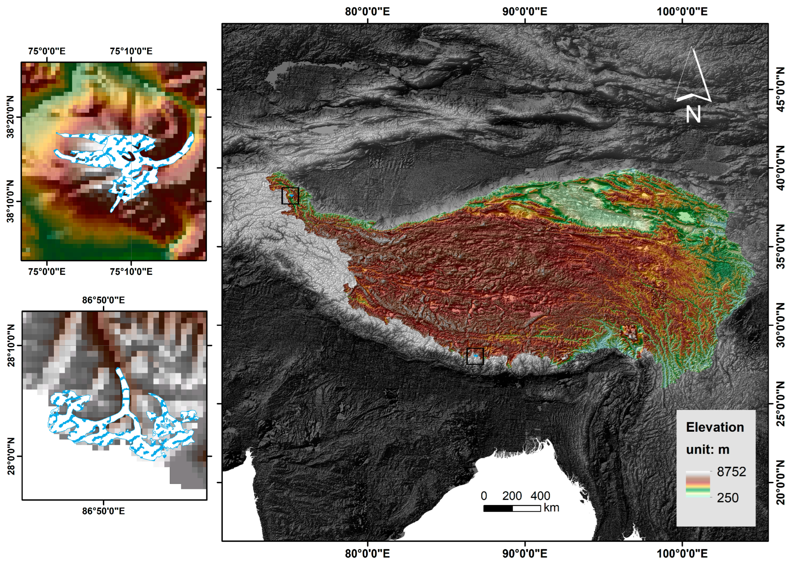
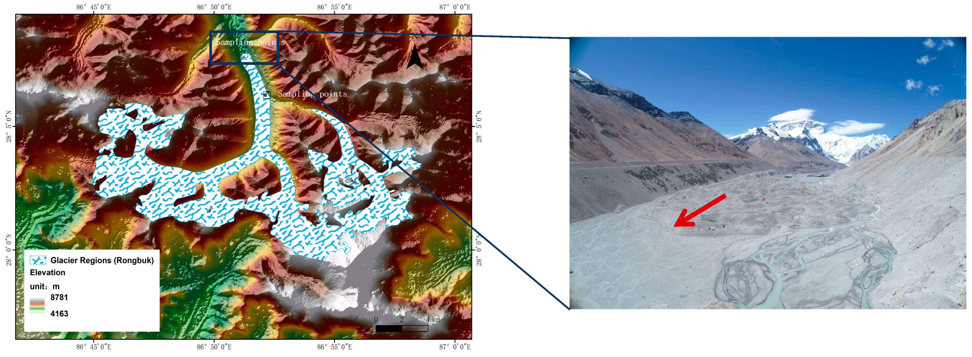
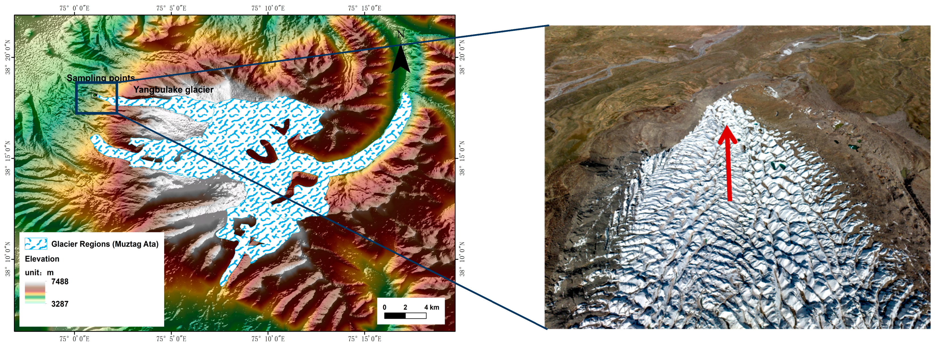
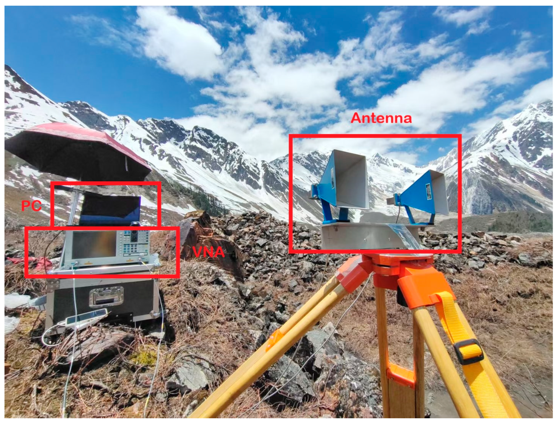
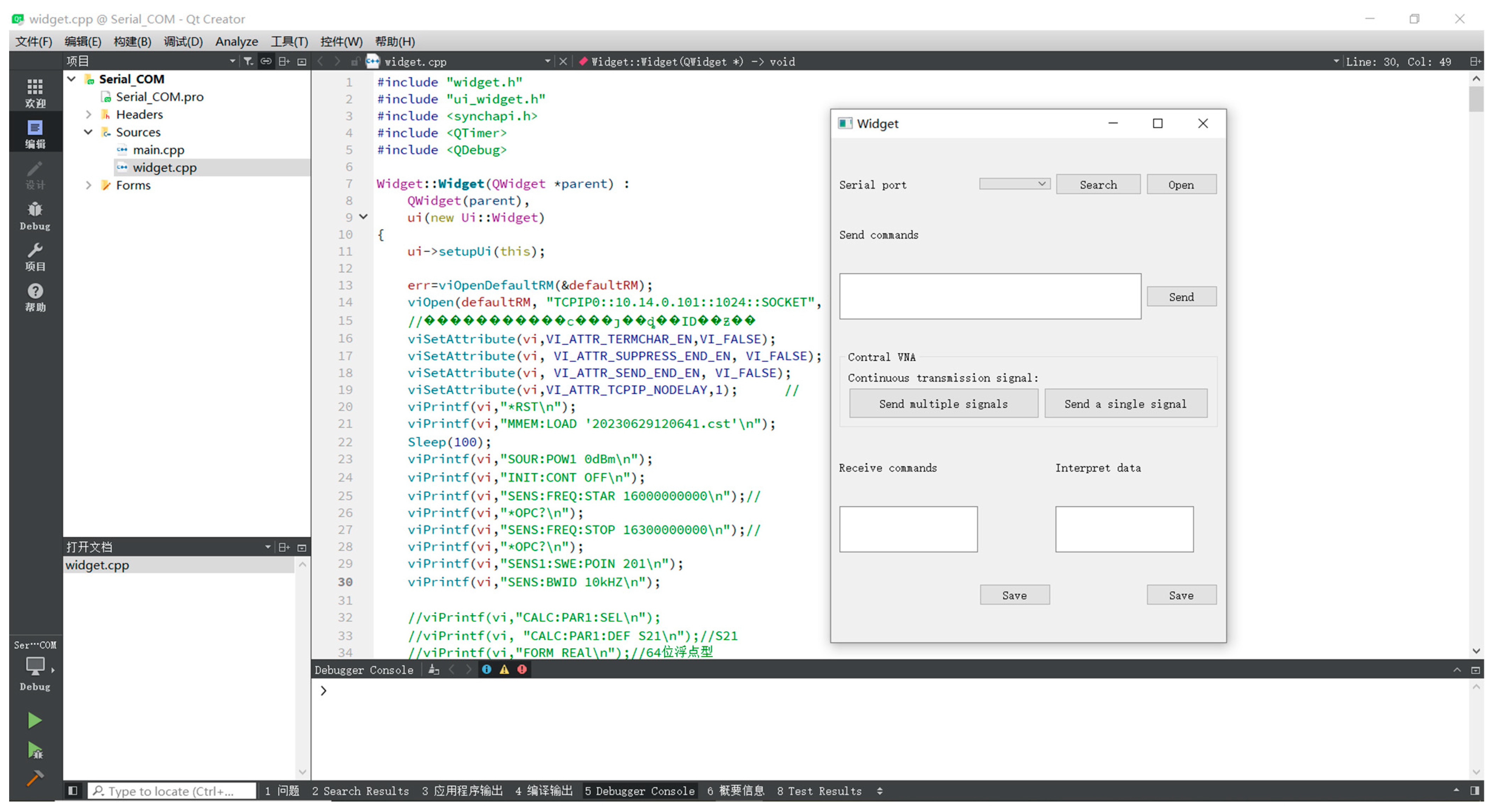
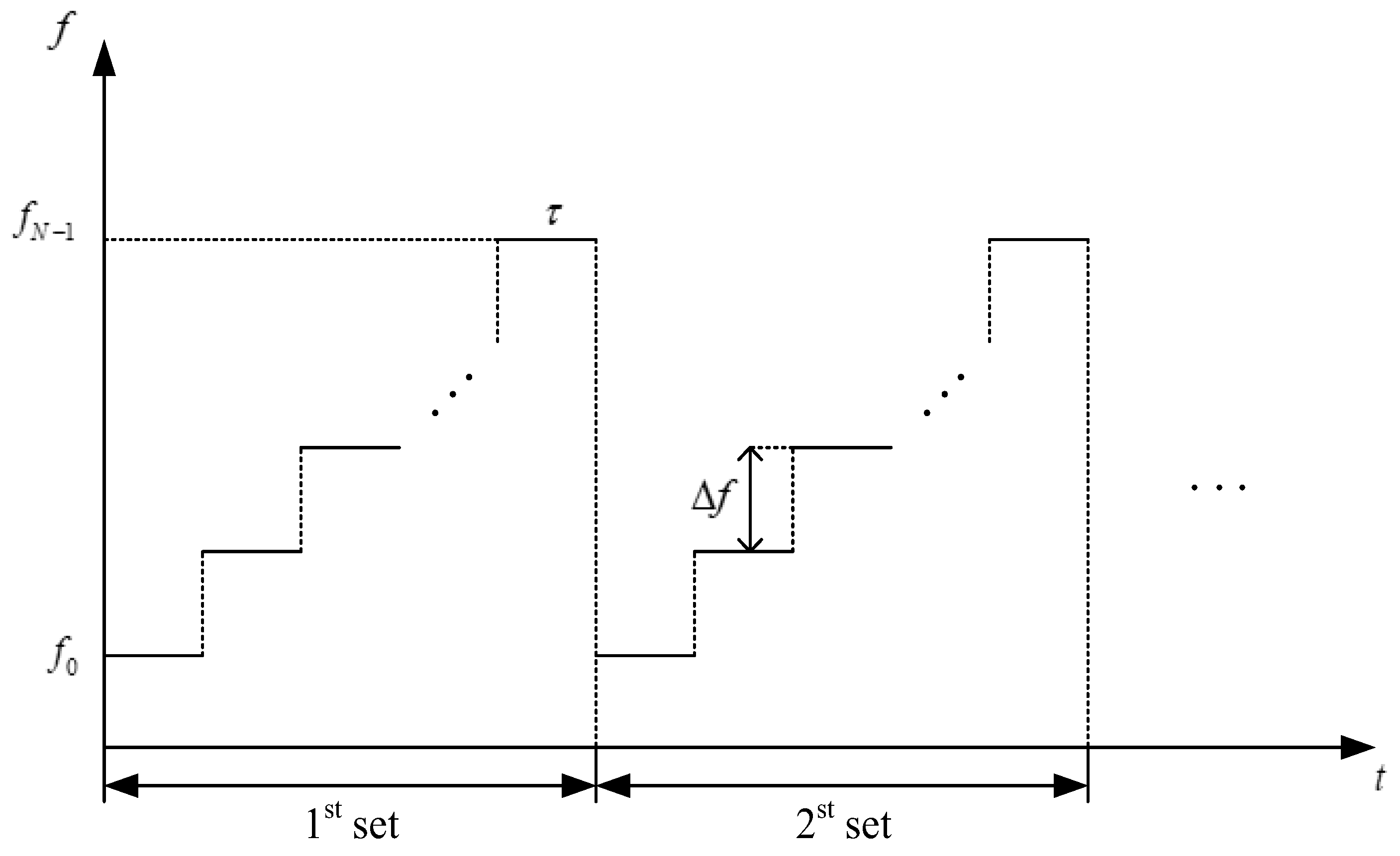
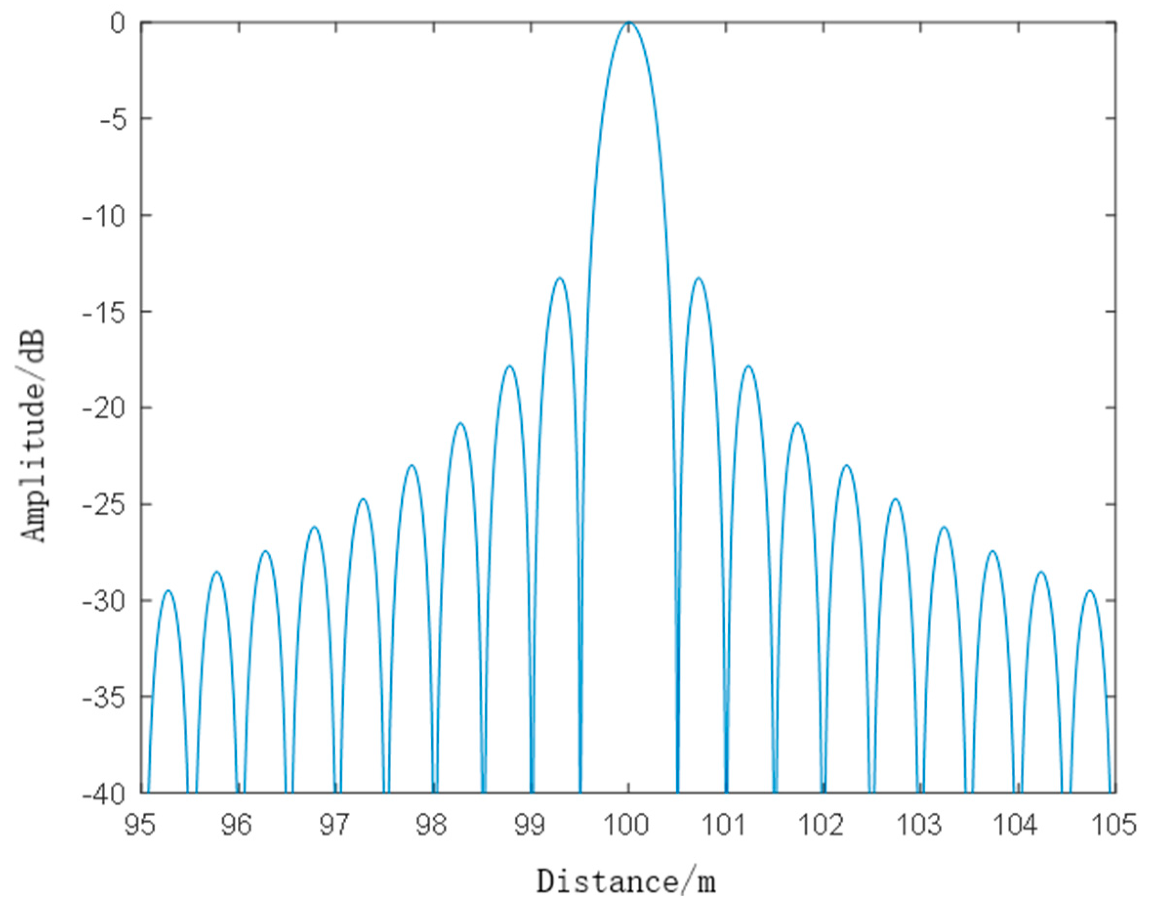
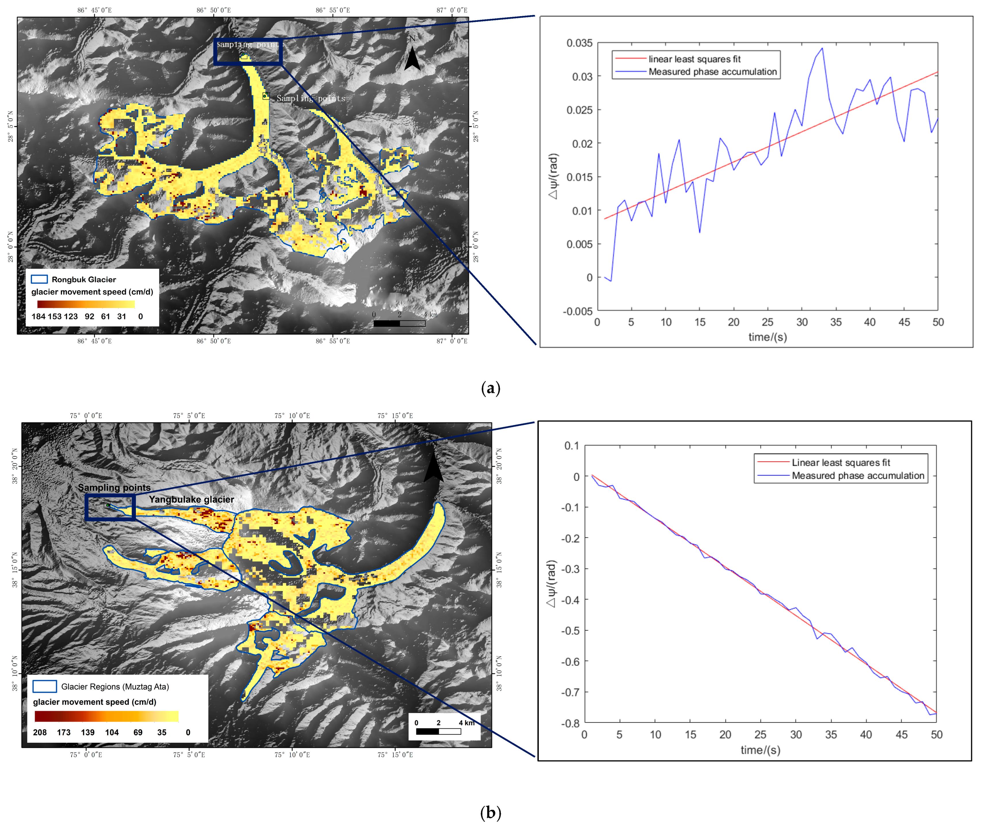
| Parameters | Value | Parameters | Value |
|---|---|---|---|
| Start frequency | 16 GHz | Pulse repeated frequency (PRF) | 20 Hz |
| Bandwidth | 300 MHz | Number N 1 | 201 |
| Intermediate Frequency (IF) bandwidth | 30 kHz | Number M 2 | 50 |
| Output power | 0 dBm |
| Parameters | Value | Parameters | Value |
|---|---|---|---|
| Frequency range | 300 kHz~20 GHz | Frequency resolution | 1 Hz |
| Measurement points | 1~160,001 | Effective directivity | 36 dB (Ku) |
| Measurement domain | Time domain, Frequency domain | Sweep frequency method | Stepped frequency |
| Impedance | 50 | IF bandwidth | 1 Hz~5 MHz |
| f | … | ||||
| Pulse No. | |||||
| 1 | … | ||||
| 2 | … | ||||
| 3 | … | ||||
| … | … | … | … | … | |
| M | … | ||||
| Image File Name | Time | Perpen-dicular | Polari-zation | Flight Direction | Study Area | ||
|---|---|---|---|---|---|---|---|
| Master Image | Slave Image | Master Image | SLAVE IMAGE | ||||
| S1A_IW_SLC__1SDV_20230605T001132_20230605T001159_048843_05DFB2_846E | S1A_IW_SLC__1SDV_20230617T001133_20230617T001200_049018_05E508_EB5D | 5 June 2023 | 17 June 2023 | 64 m | VV | Descending | Rongbuk Glacier |
| S1A_IW_SLC__1SDV_20230622T125817_20230622T125844_049099_05E777_6E14 | S1A_IW_SLC__1SDV_20230704T125818_20230704T125845_049274_05ECD4_38F1 | 22 June 2023 | 4 July 2023 | −64 m | VV | Ascending | Yangbulake Glacier |
| Glacier | Type | Sampling Points | Motion Speed by GB Radar (cm/day) | Motion Speed by Sentinel-1 (cm/day) | ||
|---|---|---|---|---|---|---|
| Longitude (°E) | Latitude (°N) | Elevation (m) | ||||
| Rongbuk Glacier | Debris-covered | 86.8689 | 28.1042 | 5197.5100 | 7.74 | 11 |
| 86.8540 | 28.1333 | 5130.7875 | 4.10 | 3 | ||
| Yangbulake Glacier | Non debris-covered | 75.0173 | 38.3020 | 4187.1825 | 198.96 | 14 |
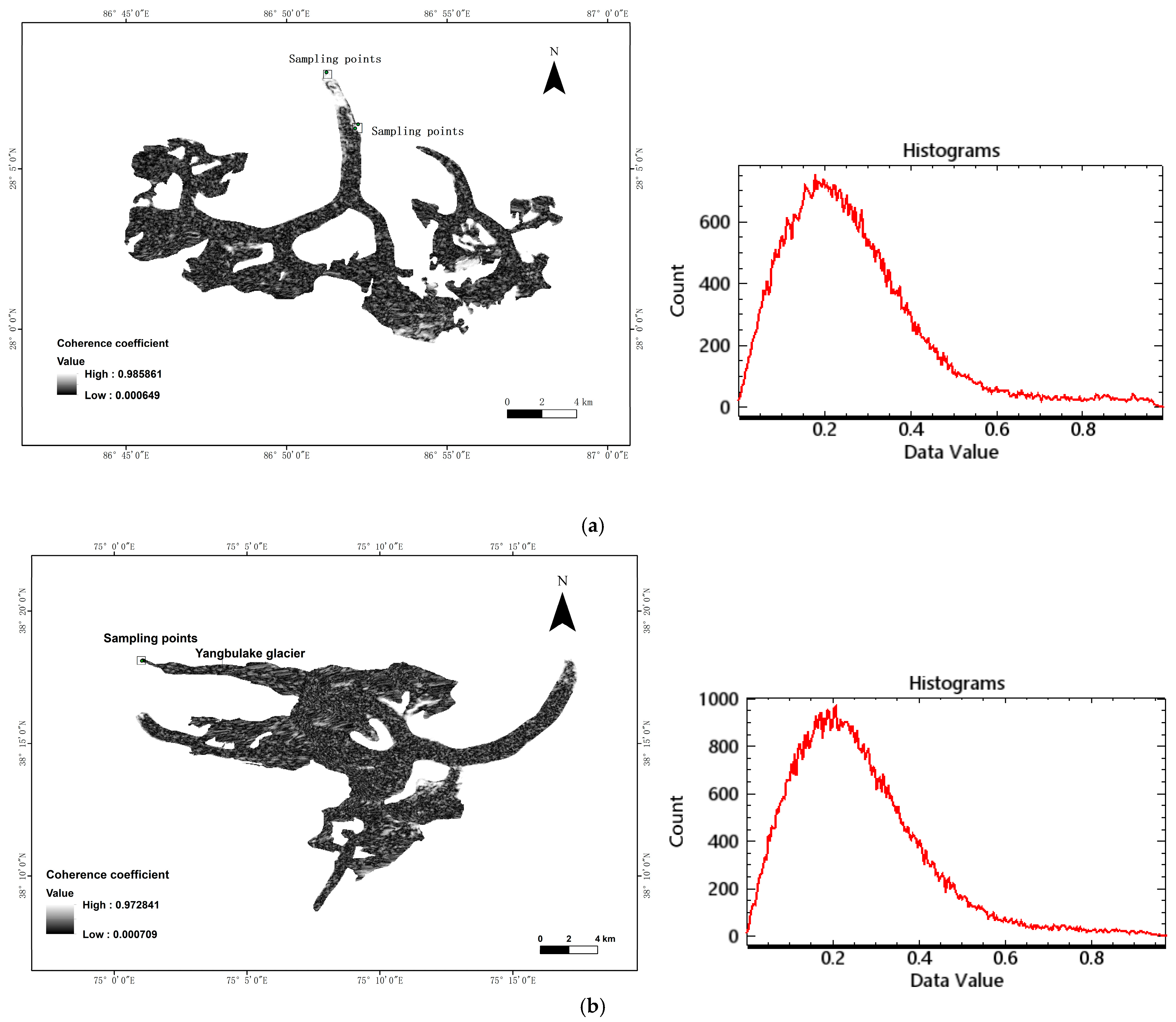
| Study Area | Min | Max | Mean | StdDev | <0.4 (%) |
|---|---|---|---|---|---|
| Rongbuk Glacier | 0.0006 | 0.9859 | 0.2694 | 0.1677 | 83.6998 |
| Yangbulake Glacier, etc. | 0.0007 | 0.9718 | 0.2622 | 0.1541 | 84.2363 |
Disclaimer/Publisher’s Note: The statements, opinions and data contained in all publications are solely those of the individual author(s) and contributor(s) and not of MDPI and/or the editor(s). MDPI and/or the editor(s) disclaim responsibility for any injury to people or property resulting from any ideas, methods, instructions or products referred to in the content. |
© 2024 by the authors. Licensee MDPI, Basel, Switzerland. This article is an open access article distributed under the terms and conditions of the Creative Commons Attribution (CC BY) license (https://creativecommons.org/licenses/by/4.0/).
Share and Cite
Zhai, L.; Ye, Q.; Liu, Y.; Liu, S.; Jia, Y.; Zhang, X. Research on Monitoring the Speed of Glacier Terminus Movement Based on the Time-Series Interferometry of a Ground-Based Radar System. Remote Sens. 2024, 16, 3928. https://doi.org/10.3390/rs16213928
Zhai L, Ye Q, Liu Y, Liu S, Jia Y, Zhang X. Research on Monitoring the Speed of Glacier Terminus Movement Based on the Time-Series Interferometry of a Ground-Based Radar System. Remote Sensing. 2024; 16(21):3928. https://doi.org/10.3390/rs16213928
Chicago/Turabian StyleZhai, Limin, Qinghua Ye, Yongqing Liu, Shuyi Liu, Yan Jia, and Xiangkun Zhang. 2024. "Research on Monitoring the Speed of Glacier Terminus Movement Based on the Time-Series Interferometry of a Ground-Based Radar System" Remote Sensing 16, no. 21: 3928. https://doi.org/10.3390/rs16213928
APA StyleZhai, L., Ye, Q., Liu, Y., Liu, S., Jia, Y., & Zhang, X. (2024). Research on Monitoring the Speed of Glacier Terminus Movement Based on the Time-Series Interferometry of a Ground-Based Radar System. Remote Sensing, 16(21), 3928. https://doi.org/10.3390/rs16213928


