Mapping Seagrass Distribution and Abundance: Comparing Areal Cover and Biomass Estimates Between Space-Based and Airborne Imagery
Abstract
1. Introduction
2. Methods
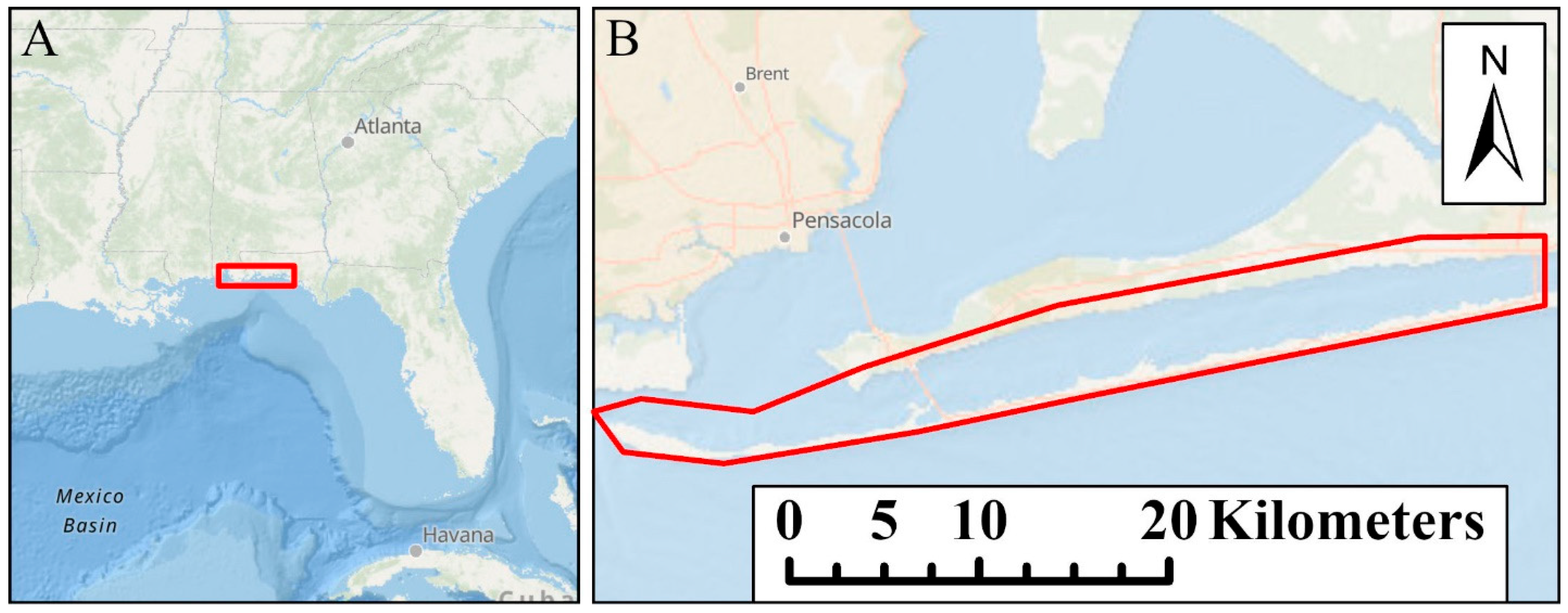
2.1. Study Area
2.2. Aerial Photography (Copied from NV5 Report)
2.3. Planet Satellite Imagery
2.3.1. Image Preprocessing
2.3.2. Classification
2.3.3. Building a Ground Truth Map
2.3.4. Leaf Area Index and Carbon Retrieval
2.3.5. Statistical Confidence of the Retrieval Estimates
3. Results
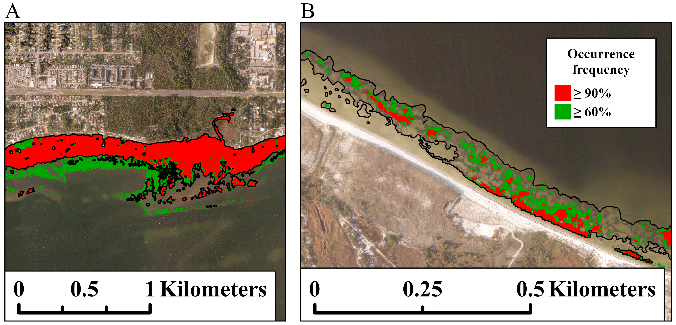
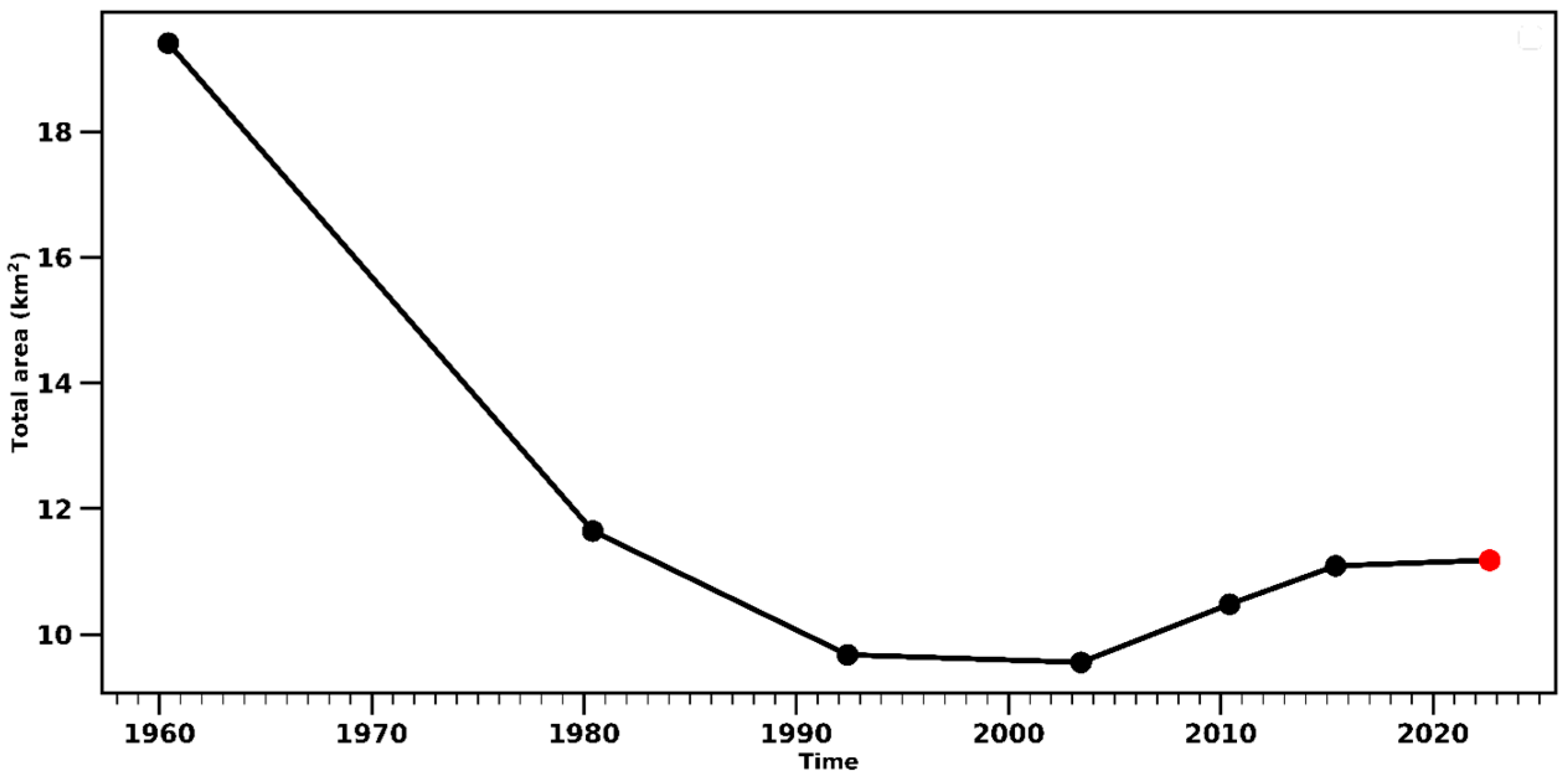
3.1. Comparison of Aerial and Planet Seagrass Distribution
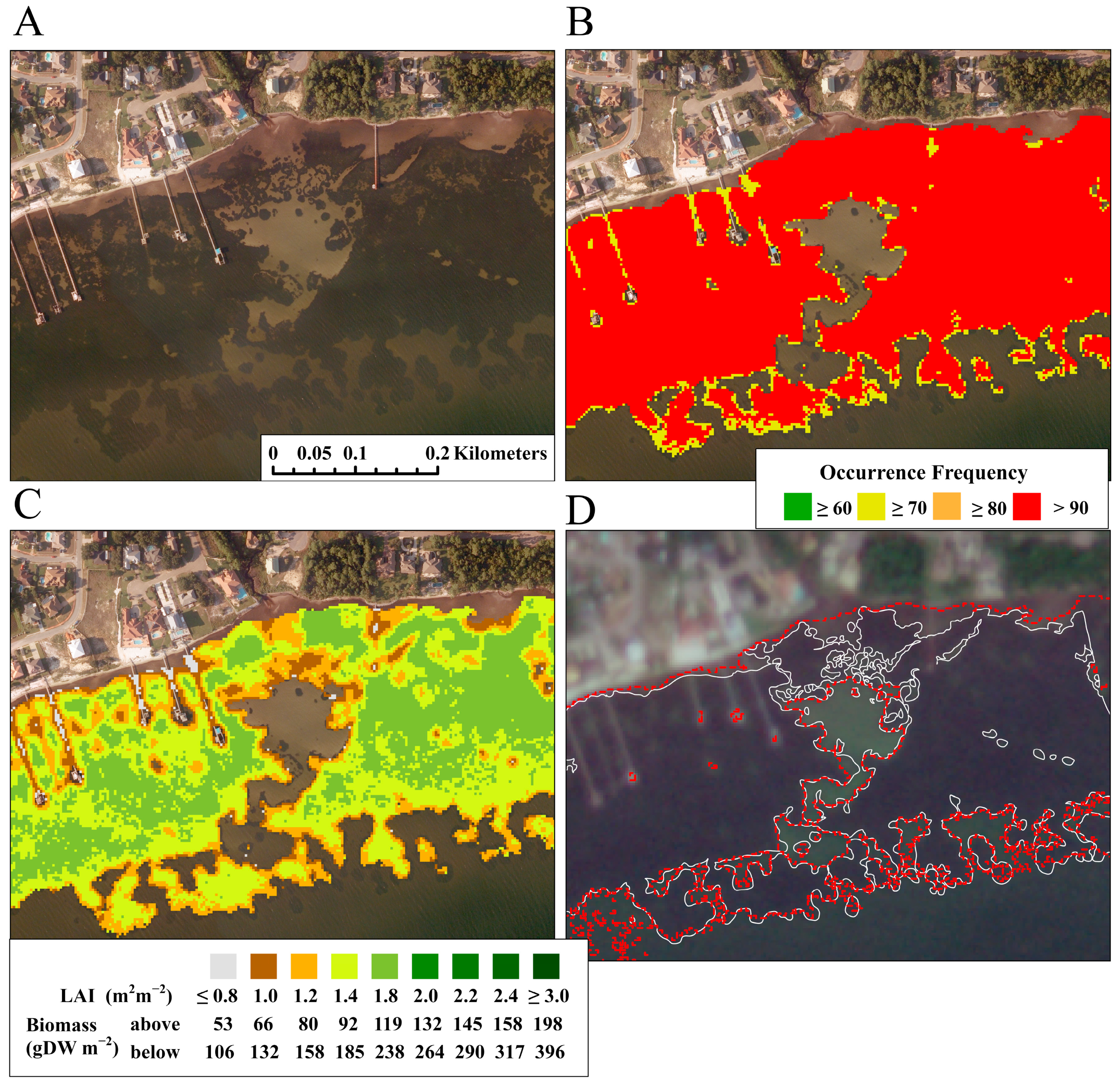
3.2. Leaf Area Index and Above- and Below-Ground Carbon
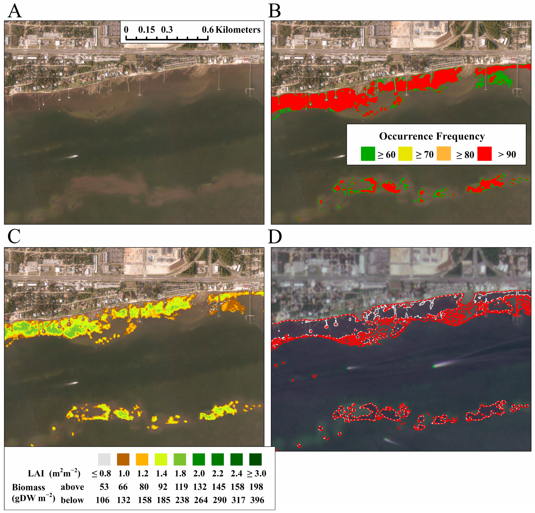
3.3. Large Continuous Seagrass Meadows
3.4. Areas of Mixed Density Within Seagrass Meadows
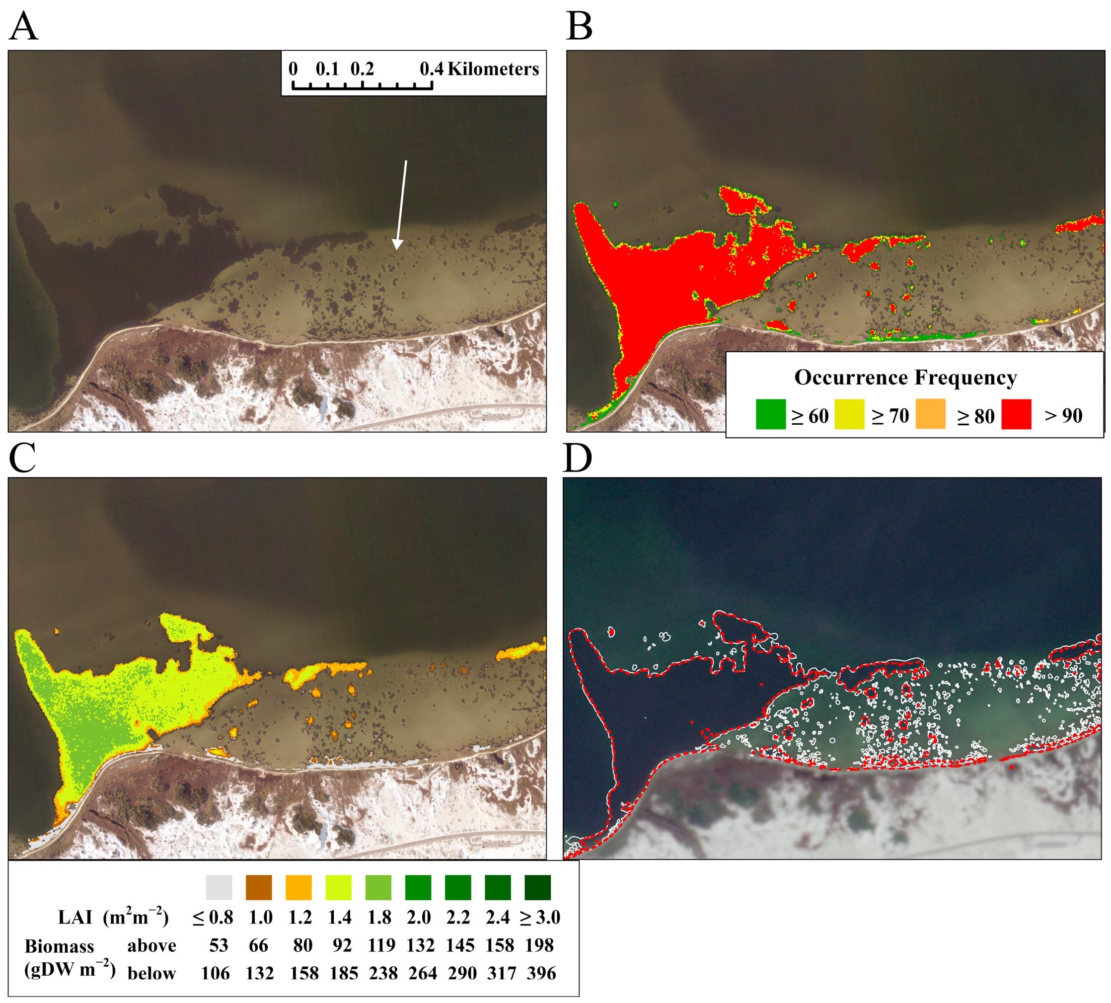
3.5. Seagrass Meadows Obscured in Aerial Imagery
3.6. Identification of Small Seagrass Patches
3.7. Retrieval Uncertainties
4. Discussion
5. Conclusions
Author Contributions
Funding
Data Availability Statement
Conflicts of Interest
References
- Lima, M.A.C.; Bergamo, T.F.; Ward, R.D.; Joyce, C.B. A review of seagrass ecosystem services: Providing nature-based solutions for a changing world. Hydrobiologia 2023, 850, 2655–2670. [Google Scholar] [CrossRef]
- McDevitt-Irwin, J.M.; Iacarella, J.C.; Baum, J.K. Reassessing the nursery role of seagrass habitats from temperate to tropical regions: A meta-analysis. Mar. Ecol. Prog. Ser. 2016, 557, 133–143. [Google Scholar] [CrossRef]
- Heck, K.L.; Thoman, T.A. The nursery role of seagrass meadows in the upper and lower reaches of the Chesapeake Bay. Estuaries 1984, 7, 70–92. [Google Scholar] [CrossRef]
- Fonseca, M.S.; Fisher, J.S.; Zieman, J.C.; Thayer, G.W. Influence of the seagrass, Zostera marina L. on current flow. Estuar. Coast. Shelf Sci. 1982, 15, 351–364. [Google Scholar] [CrossRef]
- Fonseca, M.S.; Fisher, J.S. A comparison of canopy friction and sediment movement between four species of seagrass with reference to their ecology and restoration. Mar. Ecol. Prog. Ser. 1986, 29, 5–22. [Google Scholar] [CrossRef]
- Koch, E.W.; Gust, G. Water flow in tide-and wave-dominated beds of the seagrass Thalassia testudinum. Mar. Ecol. Prog. Ser. 1999, 184, 63–72. [Google Scholar] [CrossRef]
- Koch, E.W. Beyond light: Physical, geological, and geochemical parameters as possible submersed aquatic vegetation habitat requirements. Estuaries 2001, 24, 1–17. [Google Scholar] [CrossRef]
- De Boer, W. Seagrass–sediment interactions, positive feedbacks and critical thresholds for occurrence: A review. Hydrobiologia 2007, 591, 5–24. [Google Scholar] [CrossRef]
- Potouroglou, M.; Bull, J.C.; Krauss, K.W.; Kennedy, H.A.; Fusi, M.; Daffonchio, D.; Mangora, M.M.; Githaiga, M.N.; Diele, K.; Huxham, M. Measuring the role of seagrasses in regulating sediment surface elevation. Sci. Rep. 2017, 7, 11917. [Google Scholar] [CrossRef]
- Ondiviela, B.; Losada, I.J.; Lara, J.L.; Maza, M.; Galván, C.; Bouma, T.J.; van Belzen, J. The role of seagrasses in coastal protection in a changing climate. Coast. Eng. 2014, 87, 158–168. [Google Scholar] [CrossRef]
- Mtwana Nordlund, L.; Koch, E.W.; Barbier, E.B.; Creed, J.C. Seagrass ecosystem services and their variability across genera and geographical regions. PLoS ONE 2016, 11, e0163091. [Google Scholar] [CrossRef]
- Chmura, G.; Short, F.; Torio, D.; Arroyo-Mora, P.; Fajardo, P.; Hatvany, M.; van Ardenne, L. North America’s Blue Carbon: Assessing seagrazss, Salt Marsh and Mangrove Distribution and Carbon Sinks: Project Report; Commission for Environmental Cooperation: Montreal, QC, Canada, 2016. [Google Scholar]
- Orth, R.J.; Dennison, W.C.; Gurbisz, C.; Hannam, M.; Keisman, J.; Landry, J.B.; Lefcheck, J.S.; Moore, K.A.; Murphy, R.R.; Patrick, C.J. Long-term annual aerial surveys of submersed aquatic vegetation (SAV) support science, management, and restoration. Estuaries Coasts 2022, 45, 1012–1027. [Google Scholar] [CrossRef]
- McKenzie, L.J.; Nordlund, L.M.; Jones, B.L.; Cullen-Unsworth, L.C.; Roelfsema, C.; Unsworth, R.K. The global distribution of seagrass meadows. Environ. Res. Lett. 2020, 15, 074041. [Google Scholar] [CrossRef]
- Orth, R.J.; Williams, M.R.; Marion, S.R.; Wilcox, D.J.; Carruthers, T.J.; Moore, K.A.; Kemp, W.M.; Dennison, W.C.; Rybicki, N.; Bergstrom, P. Long-term trends in submersed aquatic vegetation (SAV) in Chesapeake Bay, USA, related to water quality. Estuaries Coasts 2010, 33, 1144–1163. [Google Scholar] [CrossRef]
- Sherwood, E.T.; Greening, H.S.; Johansson, J.R.; Kaufman, K.; Raulerson, G.E. Tampa Bay (Florida, USA) documenting seagrass recovery since the 1980’s and reviewing the benefits. Southeast. Geogr. 2017, 57, 294–319. [Google Scholar] [CrossRef]
- Metz, J.L.; Harris, R.J.; Arrington, D.A. Seasonal occurrence patterns of seagrass should influence resource assessment and management decisions: A case study in the Indian River Lagoon and Loxahatchee River Estuary, Florida. Reg. Stud. Mar. Sci. 2020, 34, 101093. [Google Scholar] [CrossRef]
- Kaufman, K.A.; Bell, S.S. The Use of Imagery and GIS Techniques to Evaluate and Compare Seagrass Dynamics across Multiple Spatial and Temporal Scales. Estuaries Coasts 2020, 45, 1028–1044. [Google Scholar] [CrossRef]
- Lebrasse, M.C.; Schaeffer, B.A.; Coffer, M.; Whitman, P.J.; Zimmerman, R.C.; Hill, V.J.; Islam, K.A.; Li, J.; Osburn, C.L. Temporal Stability of Seagrass Extent, Leaf Area, and Carbon Storage in St. Joseph Bay, Florida: A Semi-automated Remote Sensing Analysis. Estuaries Coasts 2022, 45, 2082–2101. [Google Scholar] [CrossRef]
- Misbari, S.; Hashim, M. Change Detection of Submerged Seagrass Biomass in Shallow Coastal Water. Remote Sens. 2016, 8, 200. [Google Scholar] [CrossRef]
- Pu, R.; Bell, S. Mapping seagrass coverage and spatial patterns with high spatial resolution IKONOS imagery. Int. J. Appl. Earth Obs. 2017, 54, 145–158. [Google Scholar] [CrossRef]
- Phinn, S.; Roelfsema, C.; Dekker, A.; Brando, V.; Anstee, J. Mapping seagrass species, cover and biomass in shallow waters: An assessment of satellite multi-spectral and airborne hyper-spectral imaging systems in Moreton Bay (Australia). Remote Sens. Environ. 2008, 112, 3413–3425. [Google Scholar] [CrossRef]
- Roelfsema, C.M.; Lyons, M.; Kovacs, E.M.; Maxwell, P.; Saunders, M.I.; Samper-Villarreal, J.; Phinn, S.R. Multi-temporal mapping of seagrass cover, species and biomass: A semi-automated object based image analysis approach. Remote Sens. Environ. 2014, 150, 172–187. [Google Scholar] [CrossRef]
- Wicaksono, P.; Maishella, A.; Arjasakusuma, S.; Lazuardi, W.; Harahap, S.D. Assessment of WorldView-2 images for aboveground seagrass carbon stock mapping in patchy and continuous seagrass meadows. Int. J. Remote Sens. 2022, 43, 2915–2941. [Google Scholar] [CrossRef]
- Coffer, M.; Schaeffer, B.A.; Zimmerman, R.C.; Hill, V.; Li, J.; Islam, K.A.; Whitman, P.J. Performance across WorldView-2 and RapidEye for reproducible seagrass mapping. Remote Sens. Environ. 2020, 250, 112036. [Google Scholar] [CrossRef] [PubMed]
- Koedsin, W.; Intararuang, W.; Ritchie, R.J.; Huete, A. An Integrated Field and Remote Sensing Method for Mapping Seagrass Species, Cover, and Biomass in Southern Thailand. Remote Sens. 2016, 8, 292. [Google Scholar] [CrossRef]
- Zoffoli, M.L.; Gernez, P.; Rosa, P.; Le Bris, A.; Brando, V.E.; Barillé, A.-L.; Harin, N.; Peters, S.; Poser, K.; Spaias, L. Sentinel-2 remote sensing of Zostera noltei-dominated intertidal seagrass meadows. Remote Sens. Environ. 2020, 251, 112020. [Google Scholar] [CrossRef]
- Wicaksono, P.; Lazuardi, W. Assessment of PlanetScope images for benthic habitat and seagrass species mapping in a complex optically shallow water environment. Int. J. Remote Sens. 2018, 39, 5739–5765. [Google Scholar] [CrossRef]
- Veettil, B.K.; Ward, R.D.; Lima, M.D.A.C.; Stankovic, M.; Hoai, P.N.; Quang, N.X. Opportunities for seagrass research derived from remote sensing: A review of current methods. Ecol. Indic. 2020, 117, 106560. [Google Scholar] [CrossRef]
- Caffrey, J.M.; Albrecht, B.B.; Capps, R. Seagrass abundance and productivity in Pensacola Bay and Santa Rosa Sound: Final Technical Report; University of West Florida: Ferry Pass, FL, USA, 2017. [Google Scholar]
- Presley, R.; Caffrey, J.M. Nitrogen fixation in subtropical seagrass sediments: Seasonal patterns in activity in Santa Rosa Sound, Florida, USA. J. Mar. Sci. Eng. 2021, 9, 766. [Google Scholar] [CrossRef]
- Lewis, M.A.; Devereux, R.; Bourgeois, P. Seagrass distribution in the Pensacola Bay system, northwest Florida. Gulf Caribb. Res. 2008, 20, 21–28. [Google Scholar] [CrossRef][Green Version]
- Bryon, D.; Heck, K.L., Jr.; Kebart, K.; Caffrey, J.M.; Harvey, A.; Fugate, B.; Carlson, P.R., Jr.; Johnsey, E. Summary Report for the Pensacola Region. In Seagrass Integrated Mapping and Monitoring Report No. 3; Carlson, P.R., Jr., Johnsey, E., Eds.; Fish and Wildlife Research Institute Technical Report TR-17 version 3; Florida Fish and Wildlife Conservation Commission: St. Petersburg, FL, USA, 2018. [Google Scholar]
- American Society for Photogrammetry and Remote Sensing. New ASPRS positional accuracy standards for digital geospatial data. Photogramm. Eng. Remote Sens. 2015, 81, 277. [Google Scholar] [CrossRef]
- Cooperative Institute for Research in Environmental Sciences (CIRES) at the University of Colorado Boulder. Continuously Updated Digital Elevation Model (CUDEM)—1/9 Arc-Second Resolution Bathymetric-Topographic Tiles. 2014. Available online: https://coast.noaa.gov/dataviewer/#/lidar/search/where:ID=8483 (accessed on 12 January 2023).
- Hill, V.J.; Zimmerman, R.C.; Bissett, P.; Dierssen, H.M.; Kohler, D. Evaluating Light Availability, Seagrass Biomass, and Productivity Using Hyperspectral Airborne Remote Sensing in Saint Joseph’s Bay, Florida. Estuaries Coasts 2014, 37, 1467–1489. [Google Scholar] [CrossRef]
- Hill, V.J.; Zimmerman, R.C.; Bissett, P.; Kohler, D.; Schaeffer, B.; Coffer, M.; Li, J.; Islam, K.A. Impact of Atmospheric Correction on Classification and Quantification of Seagrass Density from WorldView-2 Imagery. Remote Sens. 2023, 15, 4715. [Google Scholar] [CrossRef]
- Yarbro, L.A.; Carlson, P.R.; Heck, K.L.; Byron, D.; Brooke, S.; Fitzhugh, L.; Scolaro, S.; Albrecht, B.; Presley, R.; Caffrey, J.M. Biomass and Productivity of Thalassia testudinum in Estuaries of the Florida Panhandle. Gulf Caribb. Res. 2023, 34, 69–78. [Google Scholar] [CrossRef]
- Voss, K.J.; Mobley, C.D.; Sundman, L.K.; Ivey, J.E.; Mazel, C.H. The spectral upwelling radiance distribution in optically shallow waters. Limnol. Oceanogr. 2003, 48, 364–373. [Google Scholar] [CrossRef]
- Mobley, C.D. Light and Water: Radiative Transfer in Natural Waters; Academic Press: San Diego, CA, USA, 1994. [Google Scholar]
- van Tussenbroek, B.I. Above- and below-ground biomass and production by Thalassia tesudinum in a tropical reef. Aquat. Bot. 1998, 61, 69–82. [Google Scholar] [CrossRef]
- Sfriso, A.; Ghetti, P.F. Seasonal variation in biomass, morphometric parameters and production of seagrasses in the lagoon of Venice. Aquat. Bot. 1998, 61, 207–223. [Google Scholar] [CrossRef]
- Hemminga, M.A.; Duarte, C.M. Seagrass Ecology Seagrass; Cambridge University Press: Cambridge, UK, 2000. [Google Scholar]
- Devereux, R.; Yates, D.F.; Aukamp, J.; Quarles, R.L.; Jordan, S.J.; Stanley, R.S.; Eldridge, P.M. Interactions of Thalassia testudinum and sediment biogeochemistry in Santa Rosa Sound, NW Florida. Mar. Biol. Res. 2011, 7, 317–331. [Google Scholar] [CrossRef]
- Schwenning, L.; Bruce, T.; Handley, L.R. Pensacola Bay. In Seagrass Status and Trends in the Northern Gulf of Mexico: 1940–2022; Handley, L., Altsman, D., DeMay, R., Eds.; USGS Publications Warehouse: Reston, VA, USA, 2007; Volume 2006–5287, pp. 129–142. [Google Scholar]
- Vanhellemont, Q. Evaluation of eight band SuperDove imagery for aquatic applications. Opt. Express 2023, 31, 13851–13874. [Google Scholar] [CrossRef]
- Howard, J.; Hoyt, S.; Isensee, K.; Telszewski, M.; Pidgeon, E. (Eds.) Coastal Blue Carbon: Methods for Assessing Carbon Stocks and Emissions Factors in Mangroves, Tidal Salt Marshes, and Seagrasses; Conservation International, Intergovernmental Oceanographic Commission of UNESCO; International Union for Conservation of Nature: Arlington, Virginia, USA, 2014; Available online: https://www.unep.org/resources/publication/coastal-blue-carbon-methods-assessing-carbon-stocks-and-emissions-factors (accessed on 12 November 2024).
- Heck, K.L.; Carruthers, T.J.; Duarte, C.M.; Hughes, A.R.; Kendrick, G.; Orth, R.J.; Williams, S.W. Trophic transfers from seagrass meadows subsidize diverse marine and terrestrial consumers. Ecosystems 2008, 11, 1198–1210. [Google Scholar] [CrossRef]




| Image Acquisition Date and Time (GMT) | Tidal State Relative to MLLW (m) |
|---|---|
| 8 September 202216:07 | 0.547 |
| 13 September 2022 15:30 | 0.229 |
| 13 September 2022 16:18 | 0.227 |
| 15 September 2022 16:04 | 0.21 |
| 16 September 2022 16:03 | 0.236 |
| 17 September 2022 16:04 | 0.277 |
| 18 September 2022 16:05 | 0.328 |
| 19 September 2022 15:31 | 0.402 |
| 20 September 2022 16:05 | 0.424 |
| 25 September 2022 15:31 | 0.37 |
| Polygon Area (km2) | Number of Polygons | Percent Contribution to Total Area |
|---|---|---|
| <0.001 | 491 | 2.53 |
| 0.001–0.01 | 134 | 3.14 |
| 0.01–0.1 | 29 | 7.28 |
| 0.1–1 | 13 | 28.71 |
| >1 | 1 | 58.34 |
| Planet Occurrence Frequency (%) | Total Planet Area (km2) | True-positive Area (km2) | False-positive Area (km2) | False-Negative Area (km2) | % of Aerial Captured by Planet |
|---|---|---|---|---|---|
| ≥60 | 11.29 | 10.68 | 0.62 | 0.50 [0.11] | 95.5 |
| ≥70 | 10.64 | 10.49 | 0.15 | 0.69 [0.12] | 93.8 |
| ≥80 | 10.28 | 10.26 | 0.02 | 0.92 [0.14] | 91.8 |
| ≥90 | 9.59 | 9.59 | 0.007 | 1.59 [0.17] | 85.7 |
| Variable | This Study Mean ± 95% C.L | Other Studies (Dates Collected) Mean ± 1 S.D |
|---|---|---|
| LAI (m2 leaf m−2 seafloor) Mean ± 95% CL | 1.47± 0.64 | a 1.16 ± 0.6 (June 2016) a 1.78 ± 0.8 (July 2016) a 1.85 ± 0.71 (September 2016) |
| Above-ground fresh biomass (g FW m−2) | 487 ± 214 | a 261–625 (June–September 2016) b 200–780 (June 2002 and February 2005) |
| Above-ground dry biomass (g DW m−2) | 97 ± 42 | b 50–300 (June 2002 and February 2005) c 100–200 (2002, 2004, 2005) |
| Below-ground dry biomass (g DW m−2) | 195 ± 84 | c 200–600 (2002, 2004, 2005) |
| Total above-ground fresh biomass (Gg) | 5.3 | |
| Total above-ground dry biomass (Gg) | 1.05 | |
| Total below-ground dry biomass (Gg DW) | 2.11 | |
| Total above- + below-ground dry biomass (Gg DW) | 3.16 | |
| Total above- + below-ground carbon (Gg C) | 1.11 |
| Image Acquisition Date_Sensor ID | Total Area (km2) | Total Above-Ground Carbon (Gg) |
|---|---|---|
| 20220908_247d | 4.32 | 0.25 |
| 20220913_2403 | 4.25 | 0.26 |
| 20220917_2498 | 4.52 | 0.19 |
| 20220918_249d | 4.33 | 0.21 |
| 20220919_2448 | 4.28 | 0.21 |
| 20220920_2489 | 4.60 | 0.24 |
| 20220925_2448 | 4.24 | 0.17 |
| 50% occurrence threshold | 4.37 | |
| Mean ± 95% CI | 4.36 ± 0.10 | 0.22 ± 0.02 |
Disclaimer/Publisher’s Note: The statements, opinions and data contained in all publications are solely those of the individual author(s) and contributor(s) and not of MDPI and/or the editor(s). MDPI and/or the editor(s) disclaim responsibility for any injury to people or property resulting from any ideas, methods, instructions or products referred to in the content. |
© 2024 by the authors. Licensee MDPI, Basel, Switzerland. This article is an open access article distributed under the terms and conditions of the Creative Commons Attribution (CC BY) license (https://creativecommons.org/licenses/by/4.0/).
Share and Cite
Hill, V.J.; Zimmerman, R.C.; Byron, D.A.; Heck, K.L., Jr. Mapping Seagrass Distribution and Abundance: Comparing Areal Cover and Biomass Estimates Between Space-Based and Airborne Imagery. Remote Sens. 2024, 16, 4351. https://doi.org/10.3390/rs16234351
Hill VJ, Zimmerman RC, Byron DA, Heck KL Jr. Mapping Seagrass Distribution and Abundance: Comparing Areal Cover and Biomass Estimates Between Space-Based and Airborne Imagery. Remote Sensing. 2024; 16(23):4351. https://doi.org/10.3390/rs16234351
Chicago/Turabian StyleHill, Victoria J., Richard C. Zimmerman, Dorothy A. Byron, and Kenneth L. Heck, Jr. 2024. "Mapping Seagrass Distribution and Abundance: Comparing Areal Cover and Biomass Estimates Between Space-Based and Airborne Imagery" Remote Sensing 16, no. 23: 4351. https://doi.org/10.3390/rs16234351
APA StyleHill, V. J., Zimmerman, R. C., Byron, D. A., & Heck, K. L., Jr. (2024). Mapping Seagrass Distribution and Abundance: Comparing Areal Cover and Biomass Estimates Between Space-Based and Airborne Imagery. Remote Sensing, 16(23), 4351. https://doi.org/10.3390/rs16234351


