


Remote Sensing Extraction of Lakes on the Tibetan Plateau Based on the Google Earth Engine and Deep Learning

 , ,
, ,
Abstract
1. Introduction
2. Materials and Methods
2.1. Study Area
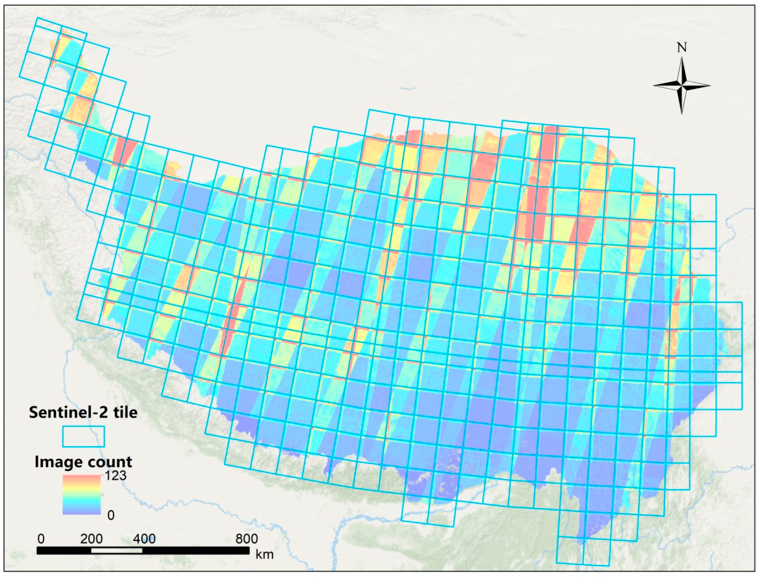
2.2. Data Sources
2.3. Methodology
2.3.1. Preparation of Sample Data
2.3.2. Deep Learning Model and Training
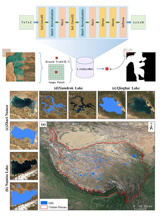
Model Architecture
Model Training and Deployment
2.3.3. Evaluation Metrics
3. Results
3.1. Lake Extraction Results
3.2. Results of Ablation Experiments
4. Discussion
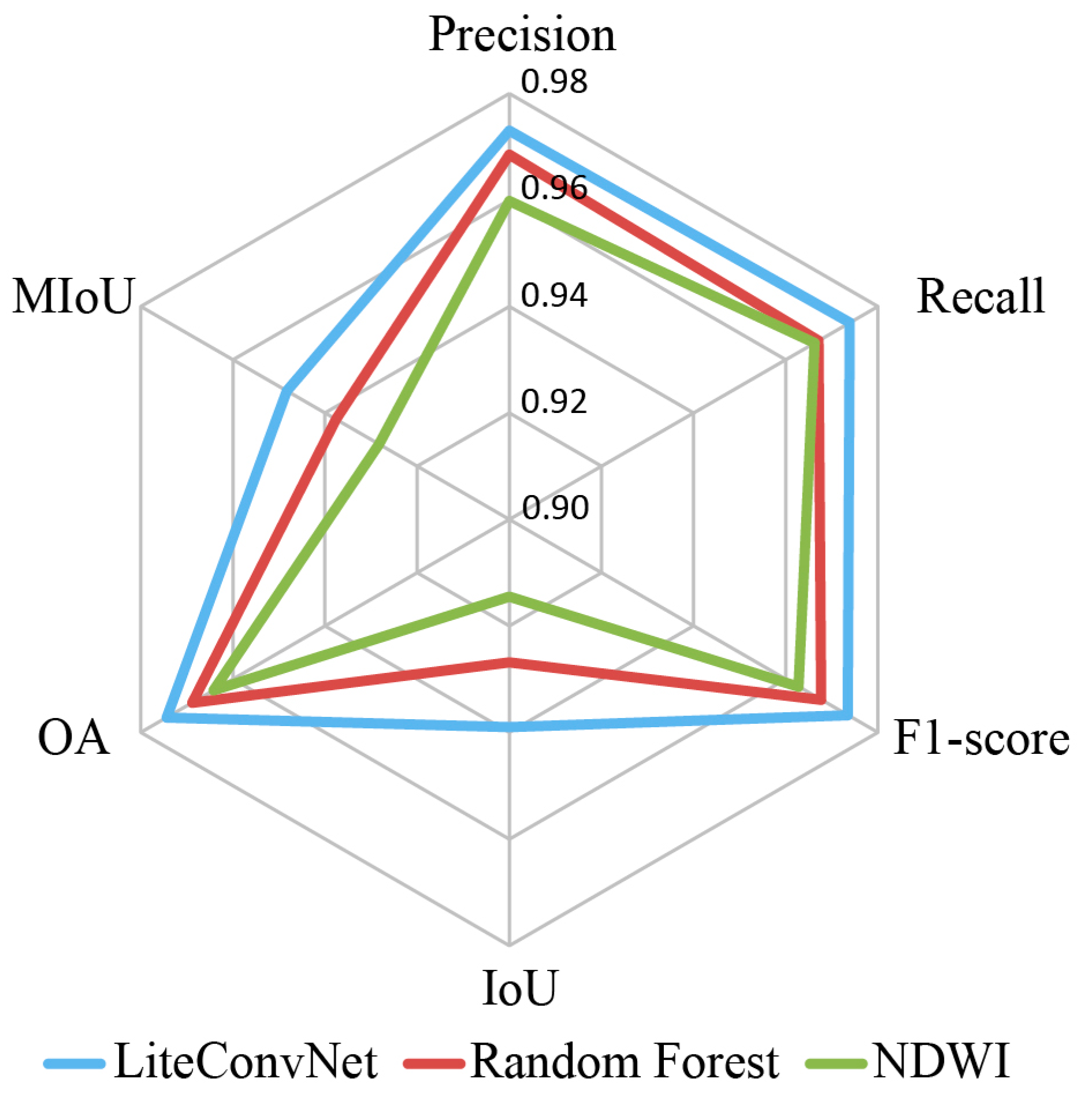
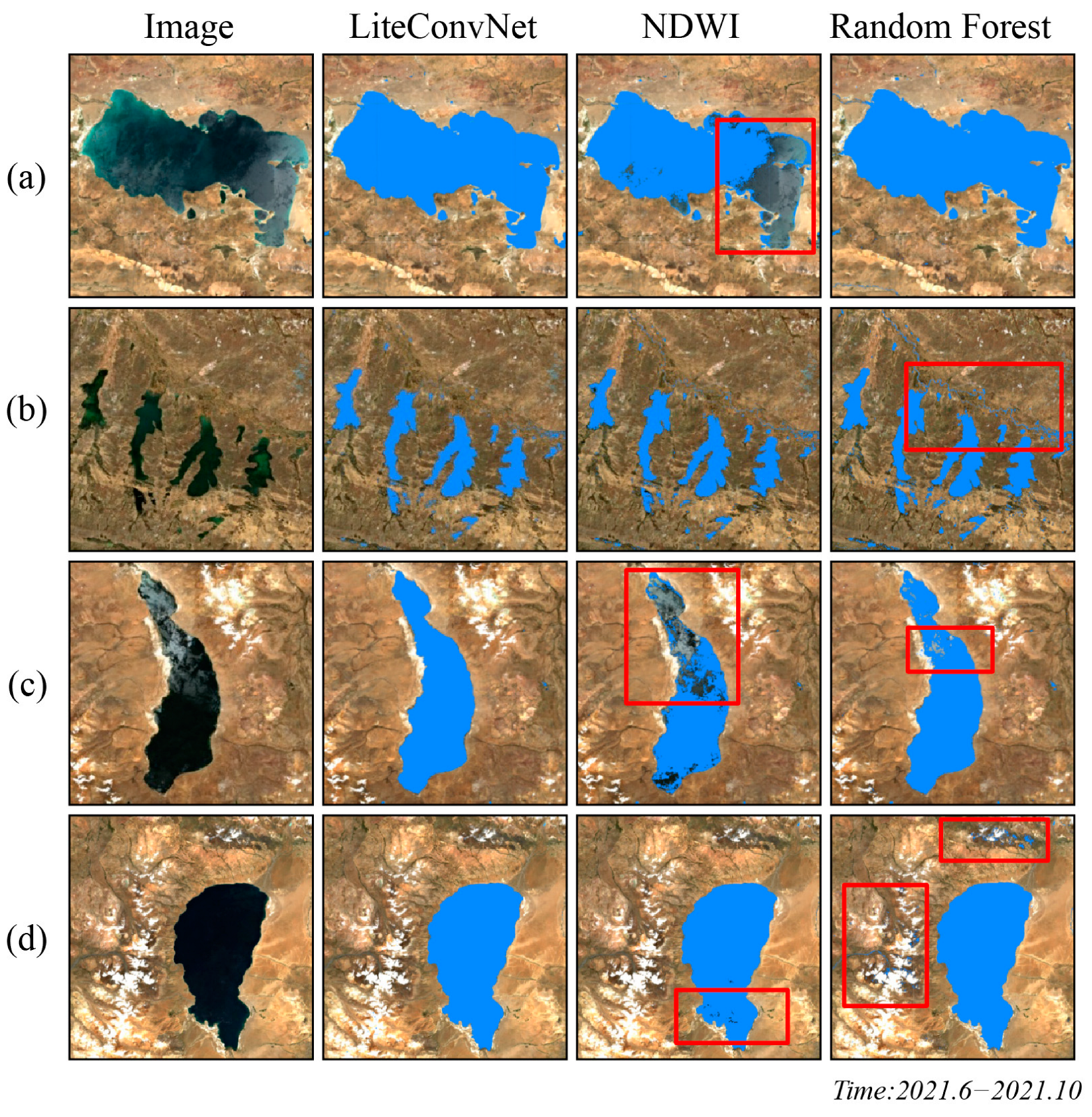
4.1. Comparison of Different Extraction Methods
4.2. Comparison of Different Water Products
4.3. Limitation
5. Conclusions
Author Contributions
Funding
Data Availability Statement
Conflicts of Interest
References
- Woolway, R.I.; Kraemer, B.M.; Lenters, J.D.; Merchant, C.J.; O’Reilly, C.M.; Sharma, S. Global lake responses to climate change. Nat. Rev. Earth Environ. 2020, 1, 388–403. [Google Scholar] [CrossRef]
- Liu, E.; Yang, X.; Shen, J.; Dong, X.; Zhang, E.; Wang, S. Environmental response to climate and human impact during the last 400 years in Taibai Lake catchment, middle reach of Yangtze River, China. Sci. Total Environ. 2007, 385, 196–207. [Google Scholar] [CrossRef] [PubMed]
- Xiong, F.; Chen, Y.; Zhang, S.; Xu, Y.; Lu, Y.; Qu, X.; Gao, W.; Wu, X.; Xin, W.; Gang, D.D.; et al. Land use, hydrology, and climate influence water quality of China’s largest river. J. Environ. Manag. 2022, 318, 115581. [Google Scholar] [CrossRef] [PubMed]
- Beeton, A.M. Large freshwater lakes: Present state, trends, and future. Environ. Conserv. 2002, 29, 21–38. [Google Scholar] [CrossRef]
- Wrigley, R.C.; Horne, A.J. Remote sensing and lake eutrophication. Nature 1974, 250, 213–214. [Google Scholar] [CrossRef]
- Roy, P.S.; Behera, M.D.; Srivastav, S.K. Satellite remote sensing: Sensors, applications and techniques. Proc. Natl. Acad. Sci. India Sect. A Phys. Sci. 2017, 87, 465–472. [Google Scholar] [CrossRef]
- McFeeters, S.K. The use of the Normalized Difference Water Index (NDWI) in the delineation of open water features. Int. J. Remote Sens. 1996, 17, 1425–1432. [Google Scholar] [CrossRef]
- Xu, H. A study on information extraction of water body with the modified normalized difference water index (MNDWI). J. Remote Sens. 2005, 9, 595. [Google Scholar]
- Wang, Q.; Liu, D.; Yang, H.; Yin, J.; Bin, Z.; Zhu, S.; Zhang, Y. Comparative study on the water index of MNDWI and NDWI for water boundary extraction in eutrophic lakes. Adv. Geosci. 2017, 7, 732–738. [Google Scholar] [CrossRef]
- Deoli, V.; Kumar, D.; Kuriqi, A. Detection of water spread area changes in eutrophic lake using landsat data. Sensors 2022, 22, 6827. [Google Scholar] [CrossRef]
- Tran, K.H.; Menenti, M.; Jia, L. Surface Water Mapping and Flood Monitoring in the Mekong Delta Using Sentinel-1 SAR Time Series and Otsu Threshold. Remote Sens. 2022, 14, 5721. [Google Scholar] [CrossRef]
- Sarp, G.; Ozcelik, M. Water body extraction and change detection using time series: A case study of Lake Burdur, Turkey. J. Taibah Univ. Sci. 2017, 11, 381–391. [Google Scholar] [CrossRef]
- Nhu, V.H.; Shahabi, H.; Nohani, E.; Shirzadi, A.; Al-Ansari, N.; Bahrami, S.; Miraki, S.; Geertsema, M.; Nguyen, H. Daily water level prediction of Zrebar Lake (Iran): A comparison between M5P, random forest, random tree and reduced error pruning trees algorithms. ISPRS Int. J. Geo-Inf. 2020, 9, 479. [Google Scholar] [CrossRef]
- Yu, L.; Wang, Z.; Tian, S.; Ye, F.; Ding, J.; Kong, J. Convolutional neural networks for water body extraction from Landsat imagery. Int. J. Comput. Intell. 2017, 16, 1750001. [Google Scholar] [CrossRef]
- Wang, Z.; Gao, X.; Zhang, Y.; Zhao, G. MSLWENet: A novel deep learning network for lake water body extraction of Google remote sensing images. Remote Sens. 2020, 12, 4140. [Google Scholar] [CrossRef]
- Gorelick, N.; Hancher, M.; Dixon, M.; Ilyushchenko, S.; Thau, D.; Moore, R. Google Earth Engine: Planetary-scale geospatial analysis for everyone. Remote Sens. Environ. 2017, 202, 18–27. [Google Scholar] [CrossRef]
- Tamiminia, H.; Salehi, B.; Mahdianpari, M.; Quackenbush, L.; Adeli, S.; Brisco, B. Google Earth Engine for geo-big data applications: A meta-analysis and systematic review. ISPRS J. Photogramm. Remote Sens. 2020, 164, 152–170. [Google Scholar] [CrossRef]
- Amani, M.; Ghorbanian, A.; Ahmadi, S.A.; Kakooei, M.; Moghimi, A.; Mirmazloumi, S.M.; Moghaddam, S.H.A.; Mahdavi, S.; Ghahremanloo, M.; Parsian, S.; et al. Google earth engine cloud computing platform for remote sensing big data applications: A comprehensive review. IEEE J. Sel. Top. Appl. Earth Obs. Remote Sens. 2020, 13, 5326–5350. [Google Scholar] [CrossRef]
- Hansen, M.C.; Potapov, P.V.; Moore, R.; Hancher, M.; Turubanova, S.A.; Tyukavina, A.; Thau, D.; Stehman, S.V.; Goetz, S.J.; Loveland, T.R.; et al. High-resolution global maps of 21st-century forest cover change. Science 2013, 342, 850–853. [Google Scholar] [CrossRef]
- Yan, Y.; Zhuang, Q.; Zan, C.; Ren, J.; Yang, L.; Wen, Y.; Zeng, S.; Zhang, Q.; Kong, L. Using the Google Earth Engine to rapidly monitor impacts of geohazards on ecological quality in highly susceptible areas. Ecol Indic. 2021, 132, 108258. [Google Scholar] [CrossRef]
- Zhao, Z.; Islam, F.; Waseem, L.A.; Tariq, A.; Nawaz, M.; Islam, I.U.; Bibi, T.; Rehman, N.U.; Ahmad, W.; Aslam, R.W.; et al. Comparison of Three Machine Learning Algorithms Using Google Earth Engine for Land Use Land Cover Classification. Rangeland Ecol. Manag. 2024, 92, 129–137. [Google Scholar] [CrossRef]
- Liu, X.; Hu, G.; Chen, Y.; Li, X.; Xu, X.; Li, S.; Pei, F.; Wang, S. High-resolution multi-temporal mapping of global urban land using Landsat images based on the Google Earth Engine Platform. Remote Sens. Environ. 2018, 209, 227–239. [Google Scholar] [CrossRef]
- Sturrock, H.J.; Cohen, J.M.; Keil, P.; Tatem, A.J.; Le Menach, A.; Ntshalintshali, N.E.; Hsiang, M.S.; Gosling, R.D. Fine-scale malaria risk mapping from routine aggregated case data. Malar. J. 2014, 13, 421. [Google Scholar] [CrossRef] [PubMed]
- Cai, Y.; Guan, K.; Peng, J.; Wang, S.; Seifert, C.; Wardlow, B.; Li, Z. A high-performance and in-season classification system of field-level crop types using time-series Landsat data and a machine learning approach. Remote Sens. Environ. 2018, 210, 35–47. [Google Scholar] [CrossRef]
- Wang, Y.; Ma, J.; Xiao, X.; Wang, X.; Dai, S.; Zhao, B. Long-term dynamic of Poyang Lake surface water: A mapping work based on the Google Earth Engine cloud platform. Remote Sens. 2019, 11, 313. [Google Scholar] [CrossRef]
- Sha, T.; Yao, X.; Wang, Y.; Tian, Z. A Quick Detection of Lake Area Changes and Hazard Assessment in the Qinghai–Tibet Plateau Based on GEE: A Case Study of Tuosu Lake. Front. Earth Sci. 2022, 10, 934033. [Google Scholar] [CrossRef]
- Li, J.; Peng, B.; Wei, Y.; Ye, H. Accurate extraction of surface water in complex environment based on Google Earth Engine and Sentinel-2. PLoS ONE 2021, 16, e0253209. [Google Scholar] [CrossRef] [PubMed]
- Chen, F.; Zhang, M.; Tian, B.; Li, Z. Extraction of glacial lake outlines in Tibet Plateau using Landsat 8 imagery and Google Earth Engine. IEEE J. Sel. Top. Appl. Earth Obs. Remote Sens. 2017, 10, 4002–4009. [Google Scholar] [CrossRef]
- Zhang, M.; Chen, F.; Guo, H.; Yi, L.; Zeng, J.; Li, B. Glacial Lake area changes in high mountain asia during 1990–2020 using satellite remote sensing. Research 2022, 2022, 9821275. [Google Scholar] [CrossRef]
- Wang, Y.; Li, Z.; Zeng, C.; Xia, G.S.; Shen, H. An urban water extraction method combining deep learning and Google Earth engine. IEEE J. Sel. Top. Appl. Earth Obs. Remote Sens. 2020, 13, 769–782. [Google Scholar] [CrossRef]
- Mayer, T.; Poortinga, A.; Bhandari, B.; Nicolau, A.P.; Markert, K.; Thwal, N.S.; Markert, A.; Haag, A.; Kilbride, J.; Chishtie, F.; et al. Deep learning approach for Sentinel-1 surface water mapping leveraging Google Earth Engine. ISPRS J. Photogramm. Remote Sens. 2021, 2, 100005. [Google Scholar] [CrossRef]
- Li, K.; Wang, J.; Cheng, W.; Wang, Y.; Zhou, Y.; Altansukh, O. Deep learning empowers the Google Earth Engine for automated water extraction in the Lake Baikal Basin. Int. J. Appl. Earth Obs. Geoinf. 2022, 112, 102928. [Google Scholar] [CrossRef]
- Shen, M.; Wang, S.; Jiang, N.; Sun, J.; Cao, R.; Ling, X.; Fang, B.; Zhang, L.; Zhang, L.; Xu, X.; et al. Plant phenology changes and drivers on the Qinghai–Tibetan Plateau. Nat. Rev. Earth Environ. 2022, 3, 633–651. [Google Scholar] [CrossRef]
- Zhang, G.; Yao, T.; Xie, H.; Yang, K.; Zhu, L.; Shum, C.K.; Bolch, T.; Yi, S.; Allen, S.; Jiang, L.; et al. Response of Tibetan Plateau lakes to climate change: Trends, patterns, and mechanisms. Earth-Sci. Rev. 2020, 208, 103269. [Google Scholar] [CrossRef]
- Zhang, Y.; Ren, H.; Pan, X. Integration Dataset of Tibet Plateau Boundary; National Tibetan Plateau Data Center: Beijing, China, 2019.
- Liu, L.; Xiao, X.; Qin, Y.; Wang, J.; Xu, X.; Hu, Y.; Qiao, Z. Mapping cropping intensity in China using time series Landsat and Sentinel-2 images and Google Earth Engine. Remote Sens. Environ. 2020, 239, 111624. [Google Scholar] [CrossRef]
- Garajeh, M.K.; Malakyar, F.; Weng, Q.; Feizizadeh, B.; Blaschke, T.; Lakes, T. An automated deep learning convolutional neural network algorithm applied for soil salinity distribution mapping in Lake Urmia, Iran. Sci. Total Environ. 2021, 778, 146253. [Google Scholar] [CrossRef] [PubMed]
- Li, Y.; Xie, W.; Li, H. Hyperspectral image reconstruction by deep convolutional neural network for classification. Pattern Recogn. 2017, 63, 371–383. [Google Scholar] [CrossRef]
- Nogueira, K.; Penatti, O.A.; Dos Santos, J.A. Towards better exploiting convolutional neural networks for remote sensing scene classification. Pattern Recogn. 2017, 61, 539–556. [Google Scholar] [CrossRef]
- Li, Z.; Liu, F.; Yang, W.; Peng, S.; Zhou, J. A survey of convolutional neural networks: Analysis, applications, and prospects. IEEE Trans. Neural Netw. Learn. Syst. 2021, 33, 6999–7019. [Google Scholar] [CrossRef]
- Pan, X.; Zhao, J. A central-point-enhanced convolutional neural network for high-resolution remote-sensing image classification. Int. J. Remote Sens. 2017, 38, 6554–6581. [Google Scholar] [CrossRef]
- Zhang, G. The Lakes Larger than 1 km2 in Tibetan Plateau (v3.1) (1970s–2022); Third Pole Environment Data Center (TPDC) : Beijing, China, 2019; Volume 10.
- Phan, T.N.; Kuch, V.; Lehnert, L.W. Land cover classification using Google Earth Engine and random forest classifier—The role of image composition. Remote Sens. 2020, 12, 2411. [Google Scholar] [CrossRef]
- Pekel, J.F.; Cottam, A.; Gorelick, N.; Belward, A.S. High-resolution mapping of global surface water and its long-term changes. Nature 2016, 540, 418–422. [Google Scholar] [CrossRef]
- Brown, C.F.; Brumby, S.P.; Guzder-Williams, B.; Birch, T.; Hyde, S.B.; Mazzariello, J.; Czerwinski, W.; Pasquarella, V.J.; Haertel, R.; Ilyushchenko, S.; et al. Dynamic World, Near real-time global 10 m land use land cover mapping. Sci. Data 2022, 9, 251. [Google Scholar] [CrossRef]
- Karra, K.; Kontgis, C.; Statman-Weil, Z.; Mazzariello, J.C.; Mathis, M.; Brumby, S.P. Global land use/land cover with Sentinel 2 and deep learning. In Proceedings of the 2021 IEEE International Geoscience and Remote Sensing Symposium IGARSS, Brussels, Belgium, 12–16 July 2021; IEEE: Piscataway, NJ, USA, 2021; pp. 4704–4707. [Google Scholar]


| Layer | Kernel Size | Output Shape | Param |
|---|---|---|---|
| Input Layer | (7, 7, 8) | 0 | |
| Conv2D | 5 × 5 | (3, 3, 16) | 3216 |
| Batch Normalization | (3, 3, 16) | 64 | |
| ReLU | (3, 3, 16) | 0 | |
| Conv2D | 3 × 3 | (1, 1, 32) | 4640 |
| Batch Normalization | (1, 1, 32) | 128 | |
| ReLU | (1, 1, 32) | 0 | |
| Dense | (1, 1, 16) | 528 | |
| Dense | (1, 1, 2) | 34 | |
| Softmax | (1, 1, 2) | 0 |
| Precision | Recall | F1-Score | IoU | OA | MIoU | |
|---|---|---|---|---|---|---|
| LiteConvNet (7 × 7) | 0.9730 | 0.9739 | 0.9735 | 0.9483 | 0.9744 | 0.9483 |
| LiteConvNet (3 × 3) | 0.9688 | 0.9669 | 0.9678 | 0.9377 | 0.9688 | 0.9377 |
| LiteConvNet (1 × 1) | 0.9619 | 0.9642 | 0.9630 | 0.9288 | 0.9643 | 0.9288 |
| Dataset | Abbreviation | Dataset ID in GEE | Images | Time Range | Spatial Resolution |
|---|---|---|---|---|---|
| JRC Monthly Water History dataset | JRC | JRC/GSW1_4/ MonthlyHistory | Landsat5.7.8 | June–October 2021 | 30 m |
| Dynamic World | Dynamic World | GOOGLE/DYNAMICWORLD/V1 | Sentinel-2 | June–October 2021 | 10 m |
| ESRI 10 m Annual Land Use Land Cover | ESRI | projects/sat-io/open-datasets/landcover/ESRI_Global-LULC_10 m | Sentinel-2 | 2021 | 10 m |
Disclaimer/Publisher’s Note: The statements, opinions and data contained in all publications are solely those of the individual author(s) and contributor(s) and not of MDPI and/or the editor(s). MDPI and/or the editor(s) disclaim responsibility for any injury to people or property resulting from any ideas, methods, instructions or products referred to in the content. |
© 2024 by the authors. Licensee MDPI, Basel, Switzerland. This article is an open access article distributed under the terms and conditions of the Creative Commons Attribution (CC BY) license (https://creativecommons.org/licenses/by/4.0/).
Share and Cite
Pang, Y.; Yu, J.; Xi, L.; Ge, D.; Zhou, P.; Hou, C.; He, P.; Zhao, L. Remote Sensing Extraction of Lakes on the Tibetan Plateau Based on the Google Earth Engine and Deep Learning. Remote Sens. 2024, 16, 583. https://doi.org/10.3390/rs16030583
Pang Y, Yu J, Xi L, Ge D, Zhou P, Hou C, He P, Zhao L. Remote Sensing Extraction of Lakes on the Tibetan Plateau Based on the Google Earth Engine and Deep Learning. Remote Sensing. 2024; 16(3):583. https://doi.org/10.3390/rs16030583
Chicago/Turabian StylePang, Yunxuan, Junchuan Yu, Laidian Xi, Daqing Ge, Ping Zhou, Changhong Hou, Peng He, and Liu Zhao. 2024. "Remote Sensing Extraction of Lakes on the Tibetan Plateau Based on the Google Earth Engine and Deep Learning" Remote Sensing 16, no. 3: 583. https://doi.org/10.3390/rs16030583
APA StylePang, Y., Yu, J., Xi, L., Ge, D., Zhou, P., Hou, C., He, P., & Zhao, L. (2024). Remote Sensing Extraction of Lakes on the Tibetan Plateau Based on the Google Earth Engine and Deep Learning. Remote Sensing, 16(3), 583. https://doi.org/10.3390/rs16030583