Technical Note

Estimating Biomass Carbon Stocks of Inner Mongolia Grasslands Using Multi-Source Data

1
Institute of Surface-Earth System Science, School of Earth System Science, Tianjin University, Tianjin 300072, China
2
State Key Laboratory of Remote Sensing Science, Aerospace Information Research Institute, Chinese Academy of Sciences, Beijing 100049, China
3
University of Chinese Academy of Sciences, Beijing 100045, China
4
Heihe Remote Sensing Experimental Research Station, Northwest Institute of Eco-Environment and Resources, Chinese Academy of Sciences, Lanzhou 730000, China
5
Center of GeoInformatics for Public Security, School of Geographical Sciences, Guangzhou University, Guangzhou 510006, China
6
Jiangsu Zhongke Atmospheric Ecological Environment Technology Research Institute, Wuxi 214000, China
*
Author to whom correspondence should be addressed.
Remote Sens. 2025, 17(1), 29; https://doi.org/10.3390/rs17010029
Submission received: 26 November 2024 / Revised: 24 December 2024 / Accepted: 25 December 2024 / Published: 26 December 2024

Abstract

:
Accurate estimates of biomass C stocks of grasslands are crucial for grassland management and climate change mitigation efforts. Here, we estimated the mean C stocks of grasslands in the Inner Mongolia Autonomous Region (IMAR), China, in 2020 at a 10 m spatial resolution by combining multi-source data, including remote sensing, climate, topography, soil properties, and field surveys. We used the random forest model to estimate the aboveground biomass (AGB) of grasslands, achieving an R2 value of 0.83. We established a relationship between belowground biomass (BGB) and AGB using a power function based on field data, which allows us to estimate the BGB of grasslands from our AGB estimate. We estimated the mean AGB across IMAR to be 100.7 g m−2, with a total value of 1.4 × 10⁸ t. The BGB of grasslands is much higher than AGB, with mean and total values of 526.0 g m−2 and 7.4 × 10⁸ t, respectively. Consequently, our C stock estimates show that IMAR grasslands store significantly more C in their BGB (332.6 Tg C) compared to AGB (63.7 Tg C). Random forest model analyses suggested that remotely sensed vegetation indices and soil moisture are the most important predictors for estimating the AGB of grasslands in the IMAR. We highlight the important role of BGB for the C store in the Inner Mongolia grasslands.

Graphical Abstract

1. Introduction

The carbon (C) stocks of ecosystems are crucial indicators of their role in the global carbon cycle. Terrestrial ecosystems assimilate atmospheric CO2 through photosynthesis, converting it into organic matter that is stored in vegetation and soil [1]. Consequently, accurately estimating carbon stocks in ecosystems is of great significance for grassland management and global warming mitigation [2]. As one of the largest terrestrial ecosystems globally, grasslands contribute to over 20% of the total productivity of natural terrestrial vegetation [3]. Therefore, accurate assessment of the biomass C stocks of grasslands is essential to enhance grassland management practices, deepen our understanding of carbon cycling mechanisms within these ecosystems, and thus support climate mitigation efforts, such as grassland restoration, sustainable grazing, and fire loss prevention [4].
The biomass C stocks of grasslands encompass both aboveground biomass (AGB) and belowground biomass (BGB) C stocks, with the latter being particularly critical for carbon storage in grassland ecosystems. Estimating these biomass C stocks of grasslands at large scales is challenging due to the difficulty in obtaining sufficient measurements, particularly for belowground biomass C stocks (BGBC). A practicable approach is to estimate biomass C stocks from AGB, which can generally be estimated using remote sensing imagery [5,6]. The BGB, and consequently the BGBC, can then be estimated from AGB estimates based on a statistical relationship between the BGB and AGB [7,8].
Over the past several decades, numerous studies have estimated AGB and AGBC in the main terrestrial ecosystems, such as forests [9,10] and grasslands [11,12]. For grasslands, the primary methods used include field surveys [13], statistical regression models [5,8,14], data-driven models [15,16], and process-based models [17,18]. Many researches have estimated grassland AGB utilizing remotely sensed vegetation index-based regression models [8,14]. However, these models often exhibit significant uncertainties when extrapolated to large spatial scales. For example, Chapungu et al. [8] estimated grassland AGB at a regional scale by fitting a regression model between AGB and the Normalized Difference Vegetation Index (NDVI) derived from Landsat TM imagery. However, the model showed low performance, with an R2 value of 0.35. Similarly, Lyu et al. [14] reported that remotely sensed AGB models for grasslands typically had R2 ranging from 0.17 to 0.33. It has also been demonstrated that regression models for grassland AGB are unsuitable for regions characterized by high spatial heterogeneity, indicating that regression models have certain limitations in their ability to generalize. Process-based models, such as terrestrial ecosystem models, can also be used to estimate ecosystem biomass and biomass C stocks at large spatial scales [19]. However, employing process-based models for estimating C stocks involves complex model parameter calibration, and running these models at a high spatial resolution entails significant computational costs. The emergence of open-access, high spatial resolution remote sensing data, such as Sentinel-1 and Sentinel-2, along with advancements in machine learning models, provides opportunities to rapidly estimate AGB, BGB, and thus biomass C stocks of grasslands over large areas at low cost [20,21]. For example, previous studies have estimated the AGB of grasslands across broad spatial scales by combining remote sensing, climate, and topography data with field surveys, utilizing machine learning models such as random forest (RF) [16,22], support vector machine [23], and artificial neural network [24]. These studies have confirmed the effectiveness and superiority of data-driven models in estimating the AGB of grasslands. However, the performance of data-driven machine learning models is highly dependent on the predictors used in the models. The selection of suitable predictors from multi-source data is critical for achieving high accuracy in AGB estimation of grasslands.
The Inner Mongolia Autonomous Region (IMAR) represents a major pastoral area in China, covering a total area of 7.2 × 10⁵ km2 of grasslands, which accounts for 20% of the country’s total grassland area. Consequently, the IMAR is also a crucial pasture area in China. Furthermore, the significance of biomass in decision-making is underscored by the substantial losses due to climate change and fire, particularly in grassland ecosystems like those in the Inner Mongolia Autonomous Region (IMAR). Estimating the C stocks of grasslands in the IMAR can significantly contribute to China’s carbon-neutral goals and climate mitigation strategies as well as improve land management practices. Previous studies have estimated the AGB of grasslands in the IMAR at spatial resolutions ranging from 30 m to 1 km, primarily using remotely sensed vegetation indices (VIs) and machine learning models [25,26,27]. However, there has been limited research on estimating the biomass C stocks of grasslands in IMAR, particularly the BGBC. In this study, we aimed to combine Sentinel-2 data with field survey data to estimate the C stocks of grasslands across the IMAR at a 10 m spatial resolution. First, we compiled 344 AGB samples and used a random forest model to estimate the spatially explicit AGB across the IMAR. Next, we established a relationship between AGB and BGB, allowing us to estimate BGB and BGBC using our AGB estimates. Then, we calculated C stocks for both AGB and BGB, as well as the total C stocks of grasslands. Finally, we identified and explained the spatial patterns of carbon stocks in grasslands across the IMAR, highlighting significant regional variations and their driving factors. The results and data from this study are of significant value for the conservation and management of grassland ecosystems and carbon sink management in the IMAR.

2. Materials and Methods

2.1. Study Area

The IMAR, located along the northern border of China, spans approximately 2400 km from east to west and 1700 km from north to south. It covers an area of 1.183 million km2, accounting for about 12.3% of China’s total land area (Figure 1). IMAR experiences a temperate continental monsoon climate characterized by long, harsh winters and short, cool summers. The mean annual temperature ranges from −1 to 10 °C, and annual precipitation varies from 50 to 450 mm, decreasing progressively from east to west. The principal vegetation types in the region include grasslands, deserts, and forests, with grasslands occupying a significant portion of the IMAR, particularly in the central and western areas. These grasslands represent one of the largest natural rangelands in China.

2.2. Biomass Samples of Grasslands

We aim to estimate the AGB of grasslands in 2020 at a spatial resolution of 10 m, principally using Sentinel-2 imagery, which has been available since 2016. To ensure the representativeness of our data across the diverse landscapes of Inner Mongolia, we strategically compiled AGB field samples from published literature and conducted open-access field surveys. A total of 344 samples that included both the geo-referenced locations of the field plots and the corresponding sample values were collected during the growing seasons from 2016 to 2020, with a conscious effort to cover different climatic zones, including the eastern, central, and western parts of the region (Table S1 and Figure 1). In the IMAR, the growing season spans from June to August, with August typically marking the peak period of vegetation biomass. Each sample was collected from a 1 m × 1 m plot, and the biomass was processed in the laboratory to determine its dry weight (g). Of the 344, 151 samples were compiled from published papers, while the remaining 193 were obtained from the National Tibetan Plateau Science Data Center (https://data.tpdc.ac.cn/home, accessed on 19 February 2024) and the National Glacial and Permafrost Desert Science Data Center (http://www.ncdc.ac.cn/portal/, accessed on 19 February 2024). While we acknowledge the value of long-term data, the availability of high-resolution Sentinel-2 data spans from 2016 to 2020. We have maximized the use of this period to capture the variability in AGB, which is representative of the recent conditions in the Inner Mongolia grasslands.
To estimate the BGB and thus BGBC of grasslands based on AGB estimates, we also collected 231 paired AGB and BGB samples, which included the sample values, from the published literature. These samples were acquired using standard field surveys and laboratory analysis procedures.

2.3. Spatial Data of Predictors for AGB Model

We employed the random forest (RF) model to estimate the current AGB of grasslands in the IMAR. A total of 20 explanatory variables (predictors) were carefully selected for the RF model and grouped into five categories: remote sensing reflectance, terrain, climate, remotely sensed VIs, and land condition (Table 1). The remote sensing reflectance predictors included Band 5, Band 6, and Band 7 reflectance from Sentinel-2A imagery, with a spatial resolution of 20 m. Mean reflectance data during the growing seasons from 2016 to 2020 were used. Sentinel-2A Bands 5, 6, and 7 include, respectively, the red-edge chlorophyll absorption, red-edge inflection point, and near-infrared (NIR) reflectance. These bands are crucial for estimating biomass, as they capture the physiological and structural properties of vegetation. The terrain variables included the elevation, slope, topographic position index (TPI), and terrain ruggedness index (TRI). The DEM (elevation) data were derived from NASA JPL DEM data (SRTM V3). Slope, TPI, and TRI were derived from the DEM data using ArcGIS software (version 10.5, ESRI, 2016). The remotely sensed VIs included the normalized difference vegetation index (NDVI), enhanced vegetation index (EVI), ratio vegetation index (RVI), soil-adjusted vegetation index (SAVI), and optimization of soil-adjusted vegetation index (OSAVI) (Table S2). These VI predictors represent the mean values during the growing seasons from 2016 to 2020. Reflectance and VI data were accessed and processed using the Google Earth Engine platform [28]. We considered seven climate-related variables, including actual evapotranspiration (AET), soil moisture (SM), downward shortwave radiation (SR), maximum surface temperature (Tmax), vapor pressure deficit (VPD), and wind speed at a height of 10 m (wind), to represent the effects of climate on AGB in our RF model. These climate-related data were derived from the Terra Climate project, which provides monthly climate datasets for land surfaces. The land use and land cover (LULC) data used in this study were derived from the European Space Agency (ESA) WorldCover product, which offers global LULC data for 2020 and 2021 at a 10 m spatial resolution. Each numerical value in the WorldCover product represents a distinct land cover type, providing a detailed classification of the Earth’s surface. We used the 2020 LULC data to derive the LULC predictor for the RF model. To ensure consistency in spatial resolution, all data with resolutions greater than 10 m were resampled to match the 10-m resolution of the land use data using appropriate interpolation methods within the ArcGIS software.
The selection of variables for this study was guided by the overarching hypothesis that a combination of environmental factors significantly influences grassland biomass. Topographical variables, such as elevation and slope, are included due to their influence on water runoff, soil depth, and aspect-related differences in the microclimate. Climatic variables, including AET, SM, and Tmax, are critical as they directly affect plant growth and water availability. Environmental variables like the Palmer Drought Severity Index (PDSI) provide insights into the stress experienced by vegetation due to water scarcity. Remotely sensed VIs are expected to correlate with biomass, as they are proxies for vegetation health and photosynthetic activity. By integrating these variables, we aim to unravel the complex interplay of factors driving biomass distribution in the IMAR grasslands, which is essential for informed management and conservation efforts.

2.4. Modeling Above and Belowground Biomass of Grasslands

To improve the prediction accuracy and capture the non-linear relationships between the predictors and the response variable, we utilized an RF model, a decision tree-based machine learning algorithm that integrates multiple decision trees, each constructed from a distinct random sample of the dataset [29]. In this study, instead of the traditional RF model, we employed a quantile regression forest (QRF) [30] to predict AGB. Unlike RF, which retains only the mean of the observations within each node in each tree and discards other information, QRF retains all the observation values within each node and assesses the conditional distribution. This enables us to estimate the dispersion of the full conditional distribution of the response variable as a function of the explanatory variables. The dispersion can be interpreted as the uncertainty of the RF model. We implemented the quantregForest package [31] in R to run the QRF model. The uncertainties of the QRF models were represented using the standard deviations of the conditional prediction distributions.
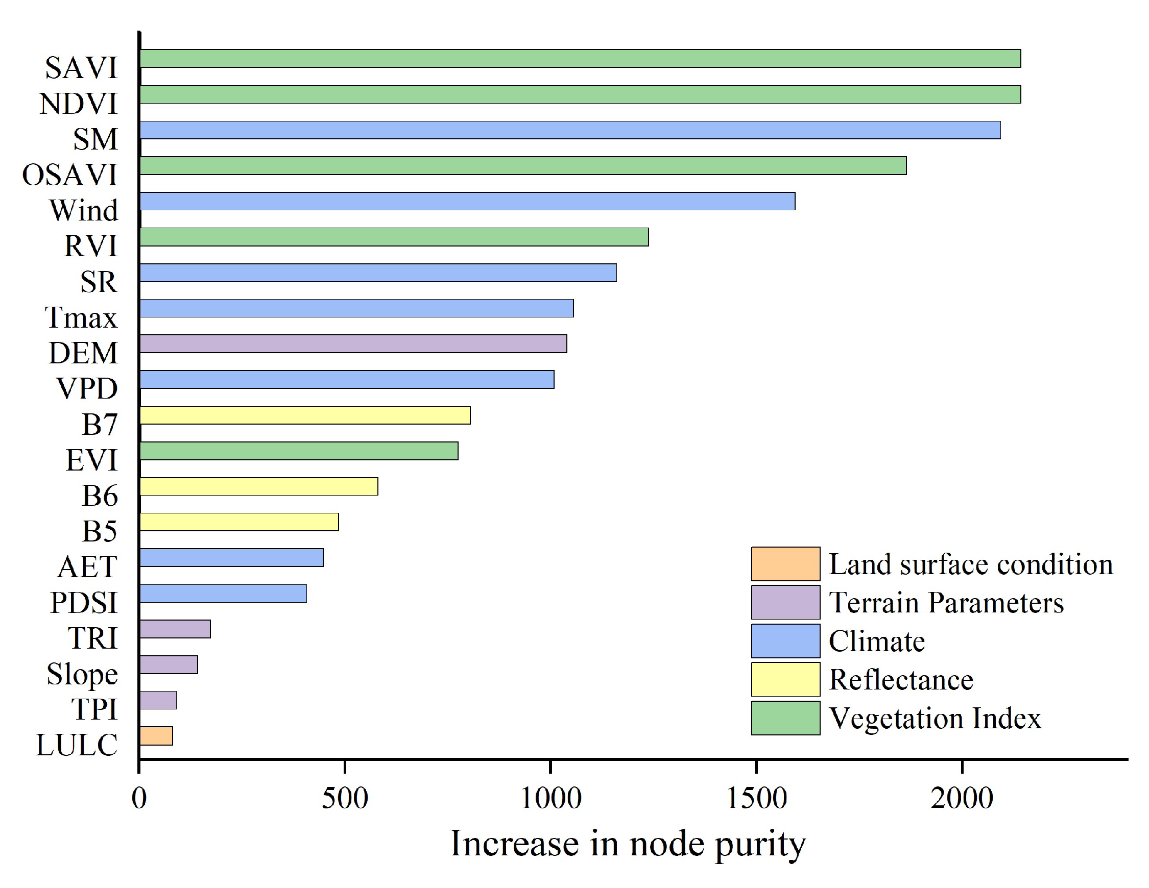
To ensure the robustness of our model, we conducted a 10-fold cross-validation using 323 of the 344 samples collected during 2016–2019. The remaining 21 samples collected during the 2020 growing season were reserved for model validation. The caret package [32] in R was employed to tune the hyperparameters mtry and ntree for the QRF model. mtry was tuned using a caret‘s tuning grid. However, ntree was tuned by training the models with various values and comparing their performance. The optimal parameters of mtry and ntree for the final QRF model were 2 and 500, respectively. To assess the relative importance of the predictors, we utilized the “Increase in node purity” metric, a standard approach in random forest models, which provides insights into the contribution of each predictor to the model’s accuracy. A higher “Increase in node purity” value indicates greater importance of the variable in the model.
We conducted comprehensive analyses of the correlations between AGB and explanatory variables. Predictors for the QRF model were selected by iteratively removing variables with low correlations to the AGB. The final QRF model was determined based on its performance assessed using the coefficient of determination (R2), root mean square error (RMSE), and mean absolute error (MAE). It was used to predict the AGB of grasslands over the IMAR in 2020 with the gridded predictors (Table 1). The AGB estimate was validated using the 21 samples collected in 2020.
We estimate the BGB of grasslands over the IMAR using our spatial AGB estimate. To this end, we test a number of statistical models, including linear regression, power regression, and exponential regression, to determine the relationship between BGB and AGB. The best-fit regression relationship was used.

2.5. Estimating C Stocks of Grasslands Across the Inner Mongolia Autonomous Region

Previous studies have used conversion coefficients to estimate biomass to C stocks from biomass estimates. The conversion coefficients vary across species. In this study, a conversion coefficient of 0.45 was employed to convert our AGB estimates to AGBC stocks for grasslands [11]. We estimated the BGB of grasslands in the IMAR from our AGB estimate using a fitting relationship between BGB and AGB. This relationship was established using our compiled paired AGB and BGB data. Similarly, the BGBC for grasslands was estimated using a conversion coefficient of 0.45 [33]. The total biomass C stocks were then estimated as the sum of AGBC and BGBC.

3. Results

3.1. Aboveground Biomass of Grasslands Across the Inner Mongolia Autonomous Region

Our analyses of the correlations between AGB and the explanatory variables show that AGB significantly correlates with Bands 5, 6, and 7 reflectance from Sentinel-2 imagery, as well as with VIs (Figure S1). Significant correlations were also observed between AGB and climate-related variables, such as SM, wind, and SR, whereas correlations with terrain, PDSI, Tmax, AET, and other terrain-related predictors were insignificant. The predictors of our final QRF model used to predict AGB include SAVI, NDVI, SM, OSAVI, Wind, RVI, SR, Tmax, DEM, VPD, B7, EVI, B6, B5, AET, PDSI, TRI, Slope, TPI, and LULC.
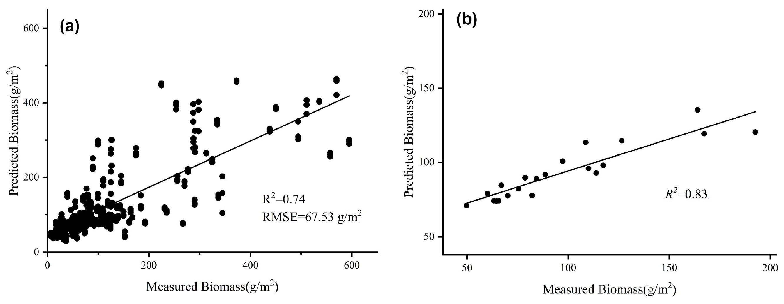
We evaluated the QRF model against the AGB samples. Our 10-fold cross-validation shows that the QRF model had R2 and RMSE values of 0.74 and 67.53 g m−2, respectively (Figure 2a). Evaluation of our AGB estimate for 2020 demonstrates high performance, with an R2 value of 0.83 (Figure 2b). These results suggest that the data-driven AGB model is effective in estimating grassland biomass in the IMAR.
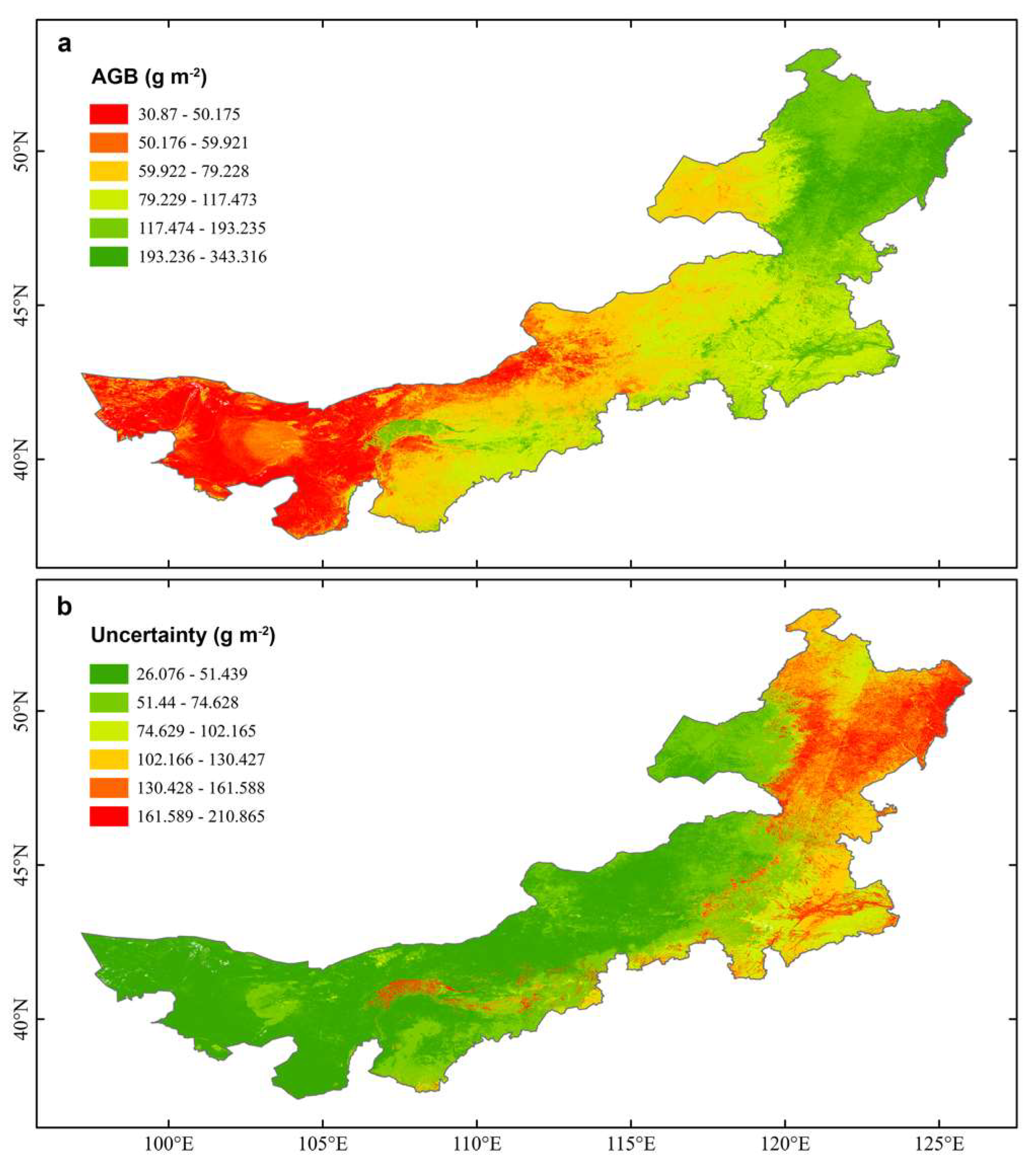
Employing the QRF model, we generated a spatially explicit estimate of the AGB across the IMAR for the year 2020 at a 10 m resolution. The spatially explicit AGB estimates exposed notable variability across the IMAR, with values ranging from 30.1 to 343.3 g m−2, indicating the heterogeneity in grassland biomass within the region (Figure 3a). The AGB estimates indicate significantly higher biomass in the eastern regions of the IMAR compared to the western regions, likely due to differences in climatic conditions and soil properties. Generally, the AGB at higher latitudes is considerably greater than that at lower latitudes. In most of the northeastern IMAR, the AGB exceeds approximately 100 g m−2, whereas in the western IMAR, the AGB typically falls below 100 g m−2. The uncertainties associated with the spatially explicit AGB estimates are shown in Figure 3b, which were derived from the standard deviations of the conditional prediction distributions of the QRF model. However, the uncertainties associated with the spatially explicit AGB estimates showed an inverse pattern to the biomass distribution, with higher uncertainties in regions with higher AGB estimates (Figure 3b). This pattern is partly due to the sparser sampling in these high biomass regions, which limits our ability to capture the local variability and accurately estimate biomass. Higher AGB estimates in the northeastern region corresponded to larger uncertainties. In contrast, the AGB estimates in the western IMAR were associated with relatively low uncertainties due to more consistent environmental conditions across the region, leading to a more predictable biomass distribution. Based on our AGB estimates, we calculated the mean and total AGB across IMAR in 2020 to be 100.7 g m−2 and 1.4 × 10⁸ t, respectively.

3.2. Belowground Biomass of Grasslands Across the Inner Mongolia Autonomous Region

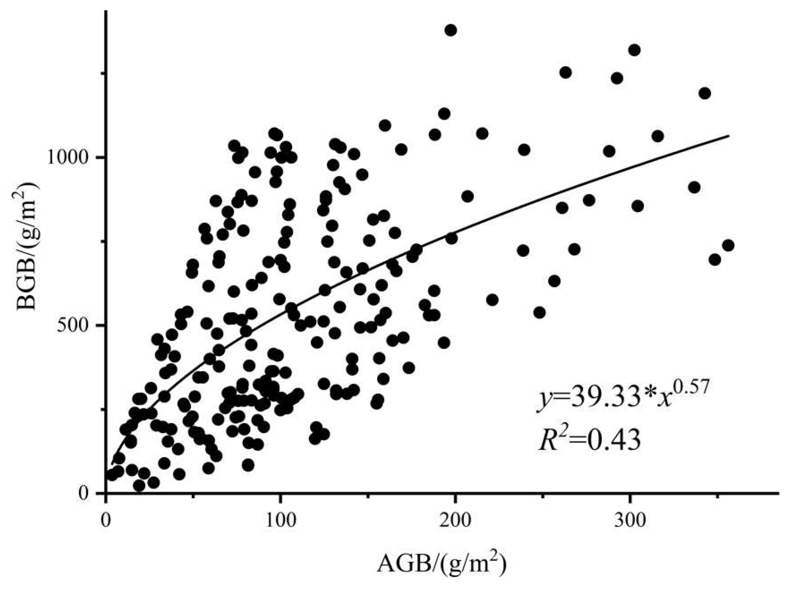
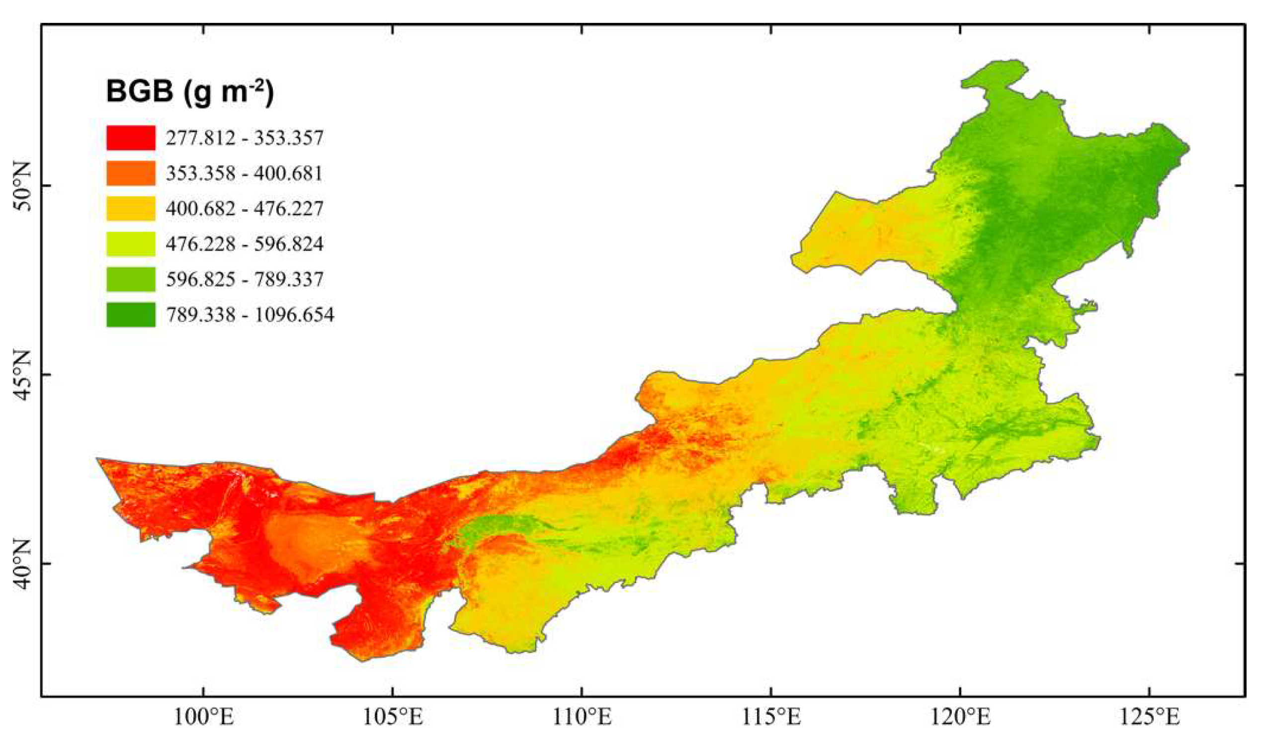
Using the collected 231 paired samples of AGB and BGB, we fitted the relationship between BGB and AGB with different statistical models (Figure 4). We found that the power regression model outperformed the other models. The power equation has an R2 value of 0.43. Utilizing this fitted relationship, we estimated the BGB across the IMAR based on our AGB estimate (Figure 3). The BGB estimate showed that BGB in the IMAR ranges from 277.8 g m−2 to 1096.7 g m−2. Consistent with the relationship between BGB and AGB, the predicted BGB values are significantly higher than their corresponding AGB values. The spatial pattern of the BGB is expected to be similar to that of the AGB. In most of the northeastern IMAR, BGB exceeds approximately 476.2 g m−2, whereas in central and western IMAR, BGB is generally below 400 g m−2. The mean BGB across IMAR in 2020 is 526.0 g m−2, which is about five times the AGB. Based on our BGB estimate, the total BGB across IMAR in 2020 is approximately 7.4 × 10⁸ t, which is about five times the total AGB. We estimated the total living biomass of grasslands, which included both AGB and BGB (Figure S2). The spatial pattern of living biomass closely aligns with the patterns observed in AGB and is expectedly similar to that of the AGB (Figure 3a) and BGB (Figure 5). The living biomass of grasslands over IMAR ranges from 308.7 to 1440.0 g m−2, with mean and total values of 626.7 g m−2 and 8.8 × 10⁸ t, respectively.

3.3. C Stocks of Living Biomass in Grasslands over the Inner Mongolia Autonomous Region

We estimated the AGBC, BGBC, and total living biomass C stocks (i.e., the sum of AGBC and BGBC) of grasslands across the IMAR using our AGB and BGB estimates. The AGBC of grasslands in the IMAR ranges from 13.9 g C m−2 to 154.5 g C m−2 (Figure 6a), with an increasing gradient from west to east. In most of the eastern IMAR and parts of the central IMAR, the AGBC values range between 14 g C m−2 and 30 g C m−2. In much of the central IMAR and several areas of the eastern region, AGBC ranges from 30 g C m−2 to 46 g C m−2. However, the northernmost and easternmost regions exhibit much higher values, exceeding 70 g C m−2. Based on our AGBC estimate, the mean and total AGBC of grasslands over the IMAR in 2020 were 45.3 g C m−2 and 63.7 Tg C, respectively.
The spatial pattern of BGBC closely resembles that of AGBC. However, BGBC values are significantly higher than those of AGBC (Figure 6b). In the western and some central areas of the IMAR, BGBC ranges from 125 g C m−2 to 184 g C m−2. However, BGBC exceeds 291.2 g C m−2 in most of the northeastern IMAR. Across much of the central IMAR, BGBC falls between 184.3 g C m−2 and 291.2 g C m−2. The mean BGBC of the grasslands across the IMAR is 236.7 g C m−2, with an estimated total BGBC of 332.6 Tg C.
Using the AGBC and BGBC estimates, we further evaluated the C stocks of living biomass across grasslands in the IMAR (Figure 6c). We estimated that grassland C stocks of living biomass range from 138.9 g C m−2 to 648.0 g C m−2. Grasslands in the northeastern IMAR exhibit the highest C stocks, with values exceeding 358.5 g C m−2. In most of the central IMAR, C stocks of living biomass fall within the range of 212.8 g C m−2 to 358.5 g C m−2. The lowest C stocks of living biomass were found in the western and some central areas of the IMAR, with values between 138.9 g C m−2 and 212.8 g C m−2. The mean and total C stocks of living biomass were estimated to be 282.0 g C m−2 and 396.3 Tg C, respectively.

3.4. Importance of the Explanatory Variables for Predicting Grassland Living Biomass

We identified the importance of the 20 explanatory variables for predicting the AGB of grasslands using the increase in node purity metric (Figure 7). The results indicate that SAVI and NDVI have the largest influence on predicting AGB, with an increase in the node purity value of 2143. They are followed by SM, OSAVI, and wind, which have an increase in node purity values exceeding 1600. Other important variables for predicting AGB include RVI, SR, Tmax, DEM, and VPD, all of which have an increase in node purity values greater than 1009. However, predictors including B7, EVI, B6, B5, AET, and PDSI show a small influence on modeling AGB, with an increase in node purity values of 805, 776, 580, 485, 448, and 408, respectively. LULC and the terrain-related variables like TRI, Slope, TPI have an even lower influence, with an increase in node purity values below 180. On average, remotely sensed VIs exhibit the most significant influence on the AGB of grasslands, with a mean increase in node purity value of 1633, followed by climate variables with a mean increase in node purity value of 1110. However, remote sensing reflectance, terrain, and land surface conditions showed relatively smaller influences, with mean increases in node purity values of 623, 362, and 82, respectively.

4. Discussion

4.1. Estimating C Stocks of Grasslands with High Spatial Resolution Remote Sensing Data

In this study, we provide a novel high-resolution assessment of C stocks in the grasslands of the IMAR at a 10 m spatial resolution, offering unprecedented detail into the spatial distribution of carbon sequestration in these ecosystems. Compared to previous biomass and C stock estimates based on MODIS [34] and Landsat [35] satellites, our higher spatial resolution estimates demonstrate higher accuracy (with an R2 value of 0.83) and provide more detailed insights into living biomass and its C stocks in grasslands, effectively capturing the spatial variability of grassland living biomass and C stocks. We included 20 explanatory variables in the RF model to predict the AGB of grasslands, including remotely sensed VIs, remote sensing reflectance, climate, terrain, and LULC. These diverse explanatory variables are more comprehensive than those used in previous studies. As a result, our literature review suggests that our data-driven model for estimating the AGB of grasslands outperformed previous regression models [5] and other machine learning models [36,37] based on the reported R2 values and other performance metrics in those studies. These findings suggest that combining field surveys with emerging high spatial resolution remote sensing data, such as Sentinel-2, along with multi-environment data in a data-driven modeling approach, significantly improves the estimation of living biomass and its C stocks in grasslands.
We estimated that the mean AGB grasslands in the IMAR is 50.0 g m−2 in 2020, which is lower than a previous estimate of 73.1 g m−2 based on MODIS imagery during 2000–2022 [38]. This discrepancy is primarily due to differences in the data and models used. Compared to AGB, BGB estimates in the IMAR are less reliable due to the lack of sufficient field measurements. Using our AGB estimate and a fitting model, we estimated the mean BGB over the IMAR in 2020 to be 526.0 g m−2, which is significantly higher than the AGB values. Based on these AGB and BGB estimates, we further quantified the AGBC, BGBC, and total C stocks of the living biomass in the IMAR. The mean AGBC and BGBC were estimated to be 45.3 g C m−2 and 236.7 g C m−2, respectively, which are close to previous estimate estimates based on statistical models (39.6 g C m−2 and 244.6 g C m−2 for AGBC and BGBC, respectively) [11]. Our estimates of the living biomass carbon stocks in grasslands underscore the substantial carbon sequestration potential of BGB, highlighting its dominance over AGB in terms of carbon storage. The total BGBC is approximately five times that of AGBC, highlighting the critical role of BGB in C storage within grasslands in the IMAR.
Our estimates of AGB, BGB, and C stock estimates clearly indicate that the living biomass and C stocks of grasslands in the IMAR are significantly higher in the northeastern part than in other regions (Figure 3, Figure 5 and Figure 6). These distinct spatial patterns are primarily determined by the region’s climatic characteristics. Most of the western IMAR experiences an arid or semi-arid climate, with annual precipitation typically below 350 mm (Figure S3a) and mean soil moisture generally less than 0.3 (Figure S3b). The grasslands in these areas are limited by water availability. The combination of high temperatures and low water resources often results in frequent droughts (Figure S3c), which further stresses vegetation growth [39]. In contrast, the northeastern IMAR benefits from higher water availability, promoting vegetation growth, and enhancing ecosystem carbon stocks.
Employing the Increase in node purity metric from our RF model, we assessed the relative importance of the 20 explanatory variables in predicting AGB across the IMAR, identifying key drivers of spatial variability in grassland biomass. The results indicated that remotely sensed VIs and climate-related variables exhibit a larger influence on the AGB of grasslands than the other variables. However, the remote sensing reflectance, terrain, and LULC variables have minimal effects on the AGB of grasslands. For the reflectance variables (B5, B6, and B7), this may be due to their limited sensitivity to variations in grasslands. The terrain variables showed minor effects on AGB, possibly because grassland coverage is not significantly correlated with the terrain in the region. Similarly, the LULC variable has a small influence on AGB, likely because the LULC data fails to capture the spatial heterogeneity within grasslands.
Our estimates of living biomass and its C stocks enhance our understanding of C storage and sequestration in grasslands, benefiting management practices such as sustainable grazing and fire loss prevention [4]. The methodologies used to estimate living biomass and its C stocks at a high spatial resolution using open-access satellite data offer valuable insights for grassland health monitoring, biodiversity conservation, and policy decision-making. Future studies should focus on long-term estimations of living biomass and C stocks, as well as identifying the drivers of inter-annual variations in living biomass and its C stocks across the IMAR.

4.2. Uncertainty in Data and Model

Our QRF model for predicting the AGB of grasslands demonstrated high performance, with an R2 value of 0.83. However, a comparison between the predicted and measured AGB suggested that the model might still underestimate AGB, particularly in areas with high AGB (Figure 2). Additionally, compared to the AGB estimate, our BGB and BGBC estimates may be associated with larger uncertainties due to uncertainties in the relationship between BGB and AGB (Figure 4). As a result, uncertainties in our estimate of C stocks in grassland living biomass mainly result from the uncertainties in the BGBC estimate. Future research should prioritize the acquisition of additional field survey data for BGB and the development of more robust models for BGB and BGBC to enhance prediction accuracy. Moreover, as Sentinel-2 data have been available only since 2016, our study did not provide long-term estimates of living biomass and its C stocks. Future studies should also aim to develop long-term satellite-based products for living biomass and its C stocks and reveal their inter-annual variations and drivers.

5. Conclusions

In this study, we combined AGB sample data with emerging open-access, high spatial resolution remote sensing data using a machine learning model to estimate AGB, BGB, and C stocks of living biomass in the grasslands of IMAR. Our estimates showed that the living biomass of grasslands exhibits evident spatial disparities. The grassland biomass was found to be higher in the northeastern region. Conversely, it decreased gradually from east to west and from north to south. Based on our spatially explicit estimates of AGB, BGB, AGBC, and BGBC, we quantified the biomass and its C stocks of grasslands over the IMAR. We found that the total BGB/BGBC ratio is approximately five times that of AGB/AGBC, suggesting the critical role of BGB for C stores in grasslands. Our model analyses indicated that remotely sensed VIs and climate-related variables exhibit the strongest correlations with the living biomass of grasslands in the IMAR, emphasizing their importance as predictive factors. This study provides valuable insights into the conservation and effective management of grassland ecosystems in the IMAR. It serves as an important reference for enhancing the carbon sink capacity of grasslands, which is essential for the sustainable use of grassland ecosystems and for maintaining ecological balance.

Supplementary Materials

The following supporting information can be downloaded at: https://www.mdpi.com/article/10.3390/rs17010029/s1, Figure S1: Pearson correlation coefficients between AGB and the 20 predictors used to predict AGB of grasslands across the Inner Mongolia Autonomous Region, China; Figure S2: Spatial distribution of grassland living biomass (i.e., the sum of aboveground and belowground biomass) over the Inner Mongolia Autonomous Region, China in 2020; Figure S3: Spatial distribution of mean annual precipitation (a), mean annual soil moisture (b), and mean annual temperature (c) over the Inner Mongolia Autonomous Region, China; Table S1: Time coverage of the collected aboveground biomass samples; Table S2: Remotely sensed vegetation index used in this study; Dataset S1: The field survey data of AGB used in this study.

Author Contributions

Conceptualization, S.S.; methodology, S.S. and Y.L.; software, Y.L.; validation, Y.L. and X.Y.; formal analysis, Y.L.; investigation, Y.L. and S.S.; resources, S.S.; data curation, Y.L.; writing—original draft preparation, Y.L.; writing—review and editing, S.S., X.W., K.L. and H.D.; visualization, Y.L. and S.S.; supervision, S.S.; project administration, S.S.; funding acquisition, S.S. All authors have read and agreed to the published version of the manuscript.

Funding

This research was funded by the National Natural Science Foundation of China (42171462).

Data Availability Statement

The raw data supporting the conclusions of this article will be made available by the authors on request.

Conflicts of Interest

The authors declare no conflicts of interest.

References

  1. Carvalhais, N.; Forkel, M.; Khomik, M.; Bellarby, J.; Jung, M.; Migliavacca, M.; Saatchi, S.; Santoro, M.; Thurner, M.; Weber, U. Global covariation of carbon turnover times with climate in terrestrial ecosystems. Nature 2014, 514, 213–217. [Google Scholar] [CrossRef]
  2. Xu, L.; Saatchi, S.S.; Yang, Y.; Yu, Y.; Pongratz, J.; Bloom, A.A.; Bowman, K.; Worden, J.; Liu, J.; Yin, Y. Changes in global terrestrial live biomass over the 21st century. Sci. Adv. 2021, 7, eabe9829. [Google Scholar] [CrossRef] [PubMed]
  3. Bai, Y.; Cotrufo, M.F. Grassland soil carbon sequestration: Current understanding, challenges, and solutions. Science 2022, 377, 603–608. [Google Scholar] [CrossRef] [PubMed]
  4. Smith, J.; Wang, L. Assessing the impact of climate on grassland biomass carbon stocks. Environ. Res. Lett. 2020, 15, 234–245. [Google Scholar]
  5. Kearney, S.P.; Porensky, L.M.; Augustine, D.J.; Gaffney, R.; Derner, J.D. Monitoring standing herbaceous biomass and thresholds in semiarid rangelands from harmonized Landsat 8 and Sentinel-2 imagery to support within-season adaptive management. Remote Sens. Environ. 2022, 271, 112907. [Google Scholar] [CrossRef]
  6. Zhang, J.; Fang, S.; Liu, H. Estimation of alpine grassland above-ground biomass and its response to climate on the Qinghai-Tibet Plateau during 2001 to 2019. Glob. Ecol. Conserv. 2022, 35, e02065. [Google Scholar] [CrossRef]
  7. Yang, Y.; Fang, J.; Ma, W.; Guo, D.; Mohammat, A. Large-scale pattern of biomass partitioning across China’s grasslands. Glob. Ecol. Biogeogr. 2010, 19, 268–277. [Google Scholar] [CrossRef]
  8. Chapungu, L.; Nhamo, L.; Gatti, R.C. Estimating biomass of savanna grasslands as a proxy of carbon stock using multispectral remote sensing. Remote Sens. Appl. Soc. Environ. 2020, 17, 100275. [Google Scholar] [CrossRef]
  9. Cuni-Sanchez, A.; Sullivan, M.J.; Platts, P.J.; Lewis, S.L.; Marchant, R.; Imani, G.; Hubau, W.; Abiem, I.; Adhikari, H.; Albrecht, T. High aboveground carbon stock of African tropical montane forests. Nature 2021, 596, 536–542. [Google Scholar] [CrossRef]
  10. Santoro, M.; Cartus, O.; Carvalhais, N.; Rozendaal, D.M.A.; Avitabile, V.; Araza, A.; de Bruin, S.; Herold, M.; Quegan, S.; Rodríguez-Veiga, P.; et al. The global forest above-ground biomass pool for 2010 estimated from high-resolution satellite observations. Earth Syst. Sci. Data 2021, 13, 3927–3950. [Google Scholar] [CrossRef]
  11. Ma, W.; Fang, J.; Yang, Y.; Mohammat, A. Biomass carbon stocks and their changes in northern China’s grasslands during 1982–2006. Sci. China Life Sci. 2010, 53, 841–850. [Google Scholar] [CrossRef] [PubMed]
  12. Spawn, S.A.; Sullivan, C.C.; Lark, T.J.; Gibbs, H.K. Harmonized global maps of above and belowground biomass carbon density in the year 2010. Sci. Data 2020, 7, 112. [Google Scholar] [CrossRef]
  13. Zhu, X.; Hou, J.; Li, M.; Xu, L.; Li, X.; Li, Y.; Cheng, C.; Zhao, W.; He, N. High-resolution spatial distribution of vegetation biomass and its environmental response on Qinghai-Tibet Plateau: Intensive grid-field survey. Ecol. Indic. 2023, 149, 110167. [Google Scholar] [CrossRef]
  14. Lyu, X.; Li, X.; Gong, J.; Li, S.; Dou, H.; Dang, D.; Xuan, X.; Wang, H. Remote-sensing inversion method for aboveground biomass of typical steppe in Inner Mongolia, China. Ecol. Indic. 2021, 120, 106883. [Google Scholar] [CrossRef]
  15. Morais, T.G.; Teixeira, R.F.; Figueiredo, M.; Domingos, T. The use of machine learning methods to estimate aboveground biomass of grasslands: A review. Ecol. Indic. 2021, 130, 108081. [Google Scholar] [CrossRef]
  16. Zhang, M.; Ma, X.; Chen, A.; Guo, J.; Xing, X.; Yang, D.; Xu, B.; Lan, X.; Yang, X. A spatio-temporal fusion strategy for improving the estimation accuracy of the aboveground biomass in grassland based on GF-1 and MODIS. Ecol. Indic. 2023, 157, 111276. [Google Scholar] [CrossRef]
  17. Schmid, J.S.; Huth, A.; Taubert, F. Influences of traits and processes on productivity and functional composition in grasslands: A modeling study. Ecol. Model. 2021, 440, 109395. [Google Scholar] [CrossRef]
  18. Wu, L.; Liu, H.; Liang, B.; Zhu, X.; Cao, J.; Wang, Q.; Jiang, L.; Cressey, E.L.; Quine, T.A. A process-based model reveals the restoration gap of degraded grasslands in Inner Mongolian steppe. Sci. Total Environ. 2022, 806, 151324. [Google Scholar] [CrossRef] [PubMed]
  19. Yang, H.; Ciais, P.; Santoro, M.; Huang, Y.; Li, W.; Wang, Y.; Bastos, A.; Goll, D.; Arneth, A.; Anthoni, P. Comparison of forest above-ground biomass from dynamic global vegetation models with spatially explicit remotely sensed observation-based estimates. Glob. Chang. Biol. 2020, 26, 3997–4012. [Google Scholar] [CrossRef]
  20. Sun, S.; Wang, Y.; Song, Z.; Chen, C.; Zhang, Y.; Chen, X.; Chen, W.; Yuan, W.; Wu, X.; Ran, X.; et al. Modelling Aboveground Biomass Carbon Stock of the Bohai Rim Coastal Wetlands by Integrating Remote Sensing, Terrain, and Climate Data. Remote Sens. 2021, 13, 4321. [Google Scholar] [CrossRef]
  21. Faqe Ibrahim, G.R.; Rasul, A.; Abdullah, H. Improving crop classification accuracy with integrated Sentinel-1 and Sentinel-2 data: A case study of barley and wheat. J. Geovisualization Spat. Anal. 2023, 7, 22. [Google Scholar] [CrossRef]
  22. Zhang, H.; Tang, Z.; Wang, B.; Kan, H.; Sun, Y.; Qin, Y.; Meng, B.; Li, M.; Chen, J.; Lv, Y.; et al. A 250 m annual alpine grassland AGB dataset over the Qinghai–Tibet Plateau (2000–2019) in China based on in situ measurements, UAV photos, and MODIS data. Earth Syst. Sci. Data 2023, 15, 821–846. [Google Scholar] [CrossRef]
  23. Ge, J.; Hou, M.; Liang, T.; Feng, Q.; Meng, X.; Liu, J.; Bao, X.; Gao, H. Spatiotemporal dynamics of grassland aboveground biomass and its driving factors in North China over the past 20 years. Sci. Total Environ. 2022, 826, 154226. [Google Scholar] [CrossRef]
  24. Zhou, J.; Zhang, R.; Guo, J.; Dai, J.; Zhang, J.; Zhang, L.; Miao, Y. Estimation of aboveground biomass of senescence grassland in China’s arid region using multi-source data. Sci. Total Environ. 2024, 918, 170602. [Google Scholar] [CrossRef]
  25. John, R.; Chen, J.; Giannico, V.; Park, H.; Xiao, J.; Shirkey, G.; Ouyang, Z.; Shao, C.; Lafortezza, R.; Qi, J. Grassland canopy cover and aboveground biomass in Mongolia and Inner Mongolia: Spatiotemporal estimates and controlling factors. Remote Sens. Environ. 2018, 213, 34–48. [Google Scholar] [CrossRef]
  26. Pang, H.; Zhang, A.; Kang, X.; He, N.; Dong, G. Estimation of the Grassland Aboveground Biomass of the Inner Mongolia Plateau Using the Simulated Spectra of Sentinel-2 Images. Remote Sens. 2020, 12, 4155. [Google Scholar] [CrossRef]
  27. Wang, G.; Luo, Z.; Huang, Y.; Sun, W.; Wei, Y.; Xiao, L.; Deng, X.; Zhu, J.; Li, T.; Zhang, W. Simulating the spatiotemporal variations in aboveground biomass in Inner Mongolian grasslands under environmental changes. Atmos. Chem. Phys. 2021, 21, 3059–3071. [Google Scholar] [CrossRef]
  28. Gorelick, N.; Hancher, M.; Dixon, M.; Ilyushchenko, S.; Thau, D.; Moore, R. Google Earth Engine: Planetary-scale geospatial analysis for everyone. Remote Sens. Environ. 2017, 202, 18–27. [Google Scholar] [CrossRef]
  29. Breiman, L. Random Forests. Mach. Learn. 2001, 45, 5–32. [Google Scholar] [CrossRef]
  30. Meinshausen, N.; Ridgeway, G. Quantile regression forests. J. Mach. Learn. Res. 2006, 7, 983–999. [Google Scholar]
  31. Meinshausen, N.; Meinshausen, M.N. Package ‘quantregForest’, R Packag e Version 1.3–7; Quantile Regression Forests: Zurich, Switzerland, 2017.
  32. Kuhn, M. Caret: Classification and regression training. Astrophys. Source Code Libr. 2015. [Google Scholar]
  33. Xin, X.; Lan, X.; Li, L.; Tang, H.; Guo, H.; Li, H.; Jiang, C.; Liu, F.; Shao, C.; Qin, Y. Anthropogenic and climate impacts on carbon stocks of grassland ecosystems in Inner Mongolia and adjacent region. Sci. Total Environ. 2024, 946, 174054. [Google Scholar] [CrossRef] [PubMed]
  34. Zhao, F.; Xu, B.; Yang, X.; Jin, Y.; Li, J.; Xia, L.; Chen, S.; Ma, H. Remote Sensing Estimates of Grassland Aboveground Biomass Based on MODIS Net Primary Productivity (NPP): A Case Study in the Xilingol Grassland of Northern China. Remote Sens. 2014, 6, 5368–5386. [Google Scholar] [CrossRef]
  35. Jansen, V.S.; Kolden, C.A.; Schmalz, H.J. The Development of Near Real-Time Biomass and Cover Estimates for Adaptive Rangeland Management Using Landsat 7 and Landsat 8 Surface Reflectance Products. Remote Sens. 2018, 10, 1057. [Google Scholar] [CrossRef]
  36. Marino, S.; Brugiapaglia, E.; Miraglia, N.; Persichilli, C.; De Angelis, M.; Pilla, F.; Di Brita, A. Modelling of the above-ground biomass and ecological composition of semi-natural grasslands on the strenght of remote sensing data and machine learning algorithms. Ecol. Inform. 2024, 82, 102740. [Google Scholar] [CrossRef]
  37. Wang, Y.; Qin, R.; Cheng, H.; Liang, T.; Zhang, K.; Chai, N.; Gao, J.; Feng, Q.; Hou, M.; Liu, J.; et al. Can Machine Learning Algorithms Successfully Predict Grassland Aboveground Biomass? Remote Sens. 2022, 14, 3843. [Google Scholar] [CrossRef]
  38. Yang, D.; Yang, Z.; Wen, Q.; Ma, L.; Guo, J.; Chen, A.; Zhang, M.; Xing, X.; Yuan, Y.; Lan, X.; et al. Dynamic monitoring of aboveground biomass in inner Mongolia grasslands over the past 23 Years using GEE and analysis of its driving forces. J. Environ. Manag. 2024, 354, 120415. [Google Scholar] [CrossRef] [PubMed]
  39. Sun, S.; Du, W.; Song, Z.; Zhang, D.; Wu, X.; Chen, B.; Wu, Y. Response of gross primary productivity to drought time-scales across China. J. Geophys. Res. Biogeosci. 2021, 126, e2020JG005953. [Google Scholar] [CrossRef]
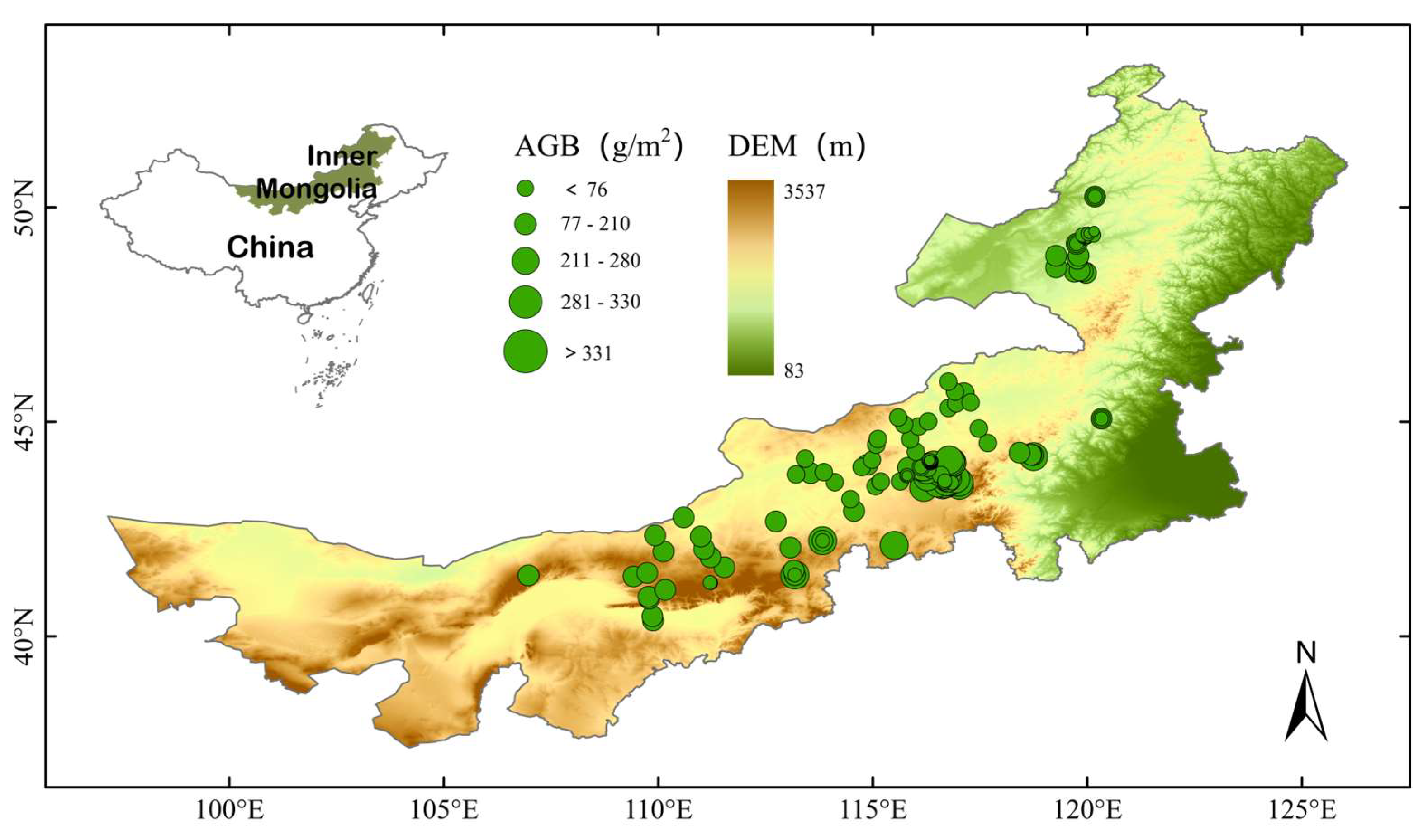
Figure 1. Location of the study area and the aboveground biomass (AGB) samples. The background map is a digital elevation model map based on NASA DEM data (https://lpdaac.usgs.gov/products/nasadem_hgtv001/, accessed on 19 February 2024).
Remotesensing 17 00029 g001
Figure 2. Comparison between measured aboveground biomass (AGB) and predicted AGB using the quantile regression forest model (a) and validation of the AGB estimate for 2020 (b). The black line indicates the linear regression relationship between the predicted and modeled AGB.
Remotesensing 17 00029 g002
Figure 3. Spatial distribution of aboveground biomass of grasslands (a) and corresponding uncertainty (b) across the Inner Mongolia Autonomous Region of China in 2020.
Remotesensing 17 00029 g003
Figure 4. Relationship between belowground biomass (BGB) and aboveground biomass (AGB) of grasslands. The black curve indicates the fitted power relationship between the BGB and AGB.
Remotesensing 17 00029 g004
Figure 5. Spatial distribution of belowground biomass of grasslands over the Inner Mongolia Autonomous Region, China, in 2020.
Remotesensing 17 00029 g005
Figure 6. Spatial distribution of C stocks of grassland living biomass across the Inner Mongolia Autonomous Region in 2020. (a) Aboveground biomass C stocks (AGBC); (b) Belowground biomass C stocks (BGBC); (c) C stocks of living biomass (i.e., the sum of AGBC and BGBC).
Remotesensing 17 00029 g006
Figure 7. Importance of the predictors for predicting aboveground biomass of grasslands. The Increase in node purity metric generated from the quantile regression forest model represents the relative importance of predictors. A higher Increase in node purity indicates greater importance of the predictors in the model.
Remotesensing 17 00029 g007
Table 1. Spatial data used to predict aboveground biomass of grasslands in the Inner Mongolia Autonomous Region, China.
PredictorDescriptionGroupSpatial ResolutionTime PeriodSource
B5Reflectance of the Sentinel-2A Band5Reflectance of Sentinel-2 imagery20 m2016–2020https://sentiwiki.copernicus.eu/web/s2-applications, accessed on 20 February 2024
B6Reflectance of the Sentinel-2A Band6
B7Reflectance of the Sentinel-2A Band7
DEMDigital elevation model (DEM)Terrain30 m2003https://cmr.earthdata.nasa.gov/search/concepts/C1000000240-LPDAAC_ECS.html, accessed on 21 February 2024
SlopeSlope derived from DEM
TPITopographic position index derived from DEM
TRITerrain ruggedness index derived from DEM
LULCLand use and land coverLand condition10 m2020https://esa-worldcover.org/en, accessed on 21 February 2024
NDVINormalized difference vegetation indexVegetation index20 m2016–2020https://sentiwiki.copernicus.eu/web/s2-applications, accessed on 22 February 2024
EVIEnhanced vegetation index
RVIRatio vegetation index
SAVISoil-adjusted vegetation index
OSAVIOptimization of soil-adjusted vegetation index
AETActual evapotranspirationClimate0.1° × 0.1°2016–2020https://developers.google.com/earth-engine/datasets/catalog/IDAHO_EPSCOR_TERRACLIMATE, accessed on 22 February 2024
PDSIPalmer drought index0.01° × 0.01°
SMSoil moisture0.1° × 0.1°
SRDownward shortwave radiation0.1° × 0.1°
TmaxMaximum surface temperature0.1° × 0.1°
VPDVapor pressure deficit0.01° × 0.01°
WindWind speed at 10 m high0.1° × 0.1°
Disclaimer/Publisher’s Note: The statements, opinions and data contained in all publications are solely those of the individual author(s) and contributor(s) and not of MDPI and/or the editor(s). MDPI and/or the editor(s) disclaim responsibility for any injury to people or property resulting from any ideas, methods, instructions or products referred to in the content.