
Progressive Shrinkage of the Alpine Periglacial Weathering Zone and Its Escalating Disaster Risks in the Gongga Mountains over the Past Four Decades


Abstract
1. Introduction
2. Materials and Methods
2.1. Study Area Overview
2.2. Data Sources and Research Methodology
Data Sources
2.3. Methodology
2.3.1. Algorithm for Extraction of the Alpine Periglacial Weathering Zone
- (1)
- Image Preprocessing
- (2)
- Index Calculation
- (3)
- Adaptive Threshold Segmentation—Otsu Method
- (4)
- Post-processing
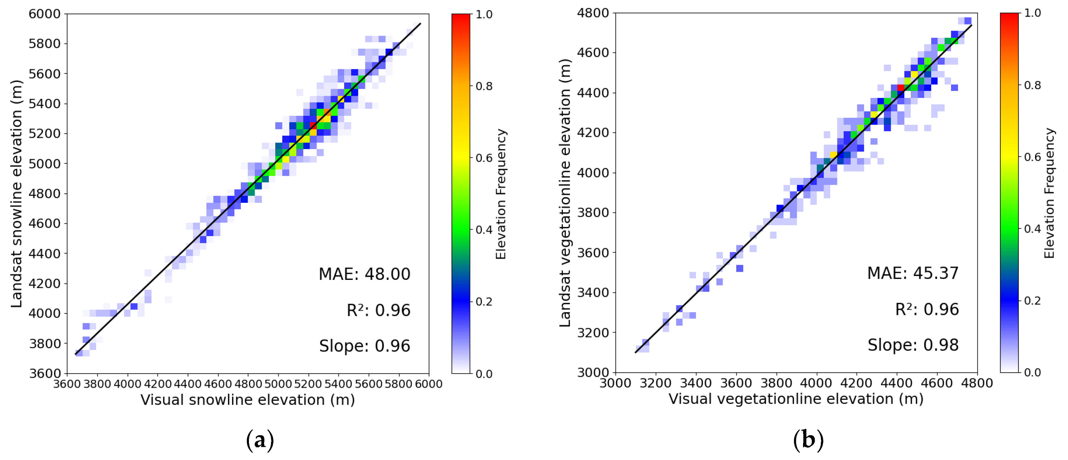
2.3.2. Accuracy Indicators
- (1)
- Indirect Accuracy Verification
- (2)
- Direct Accuracy Verification
2.3.3. Data Extraction and Statistical Analysis
3. Results
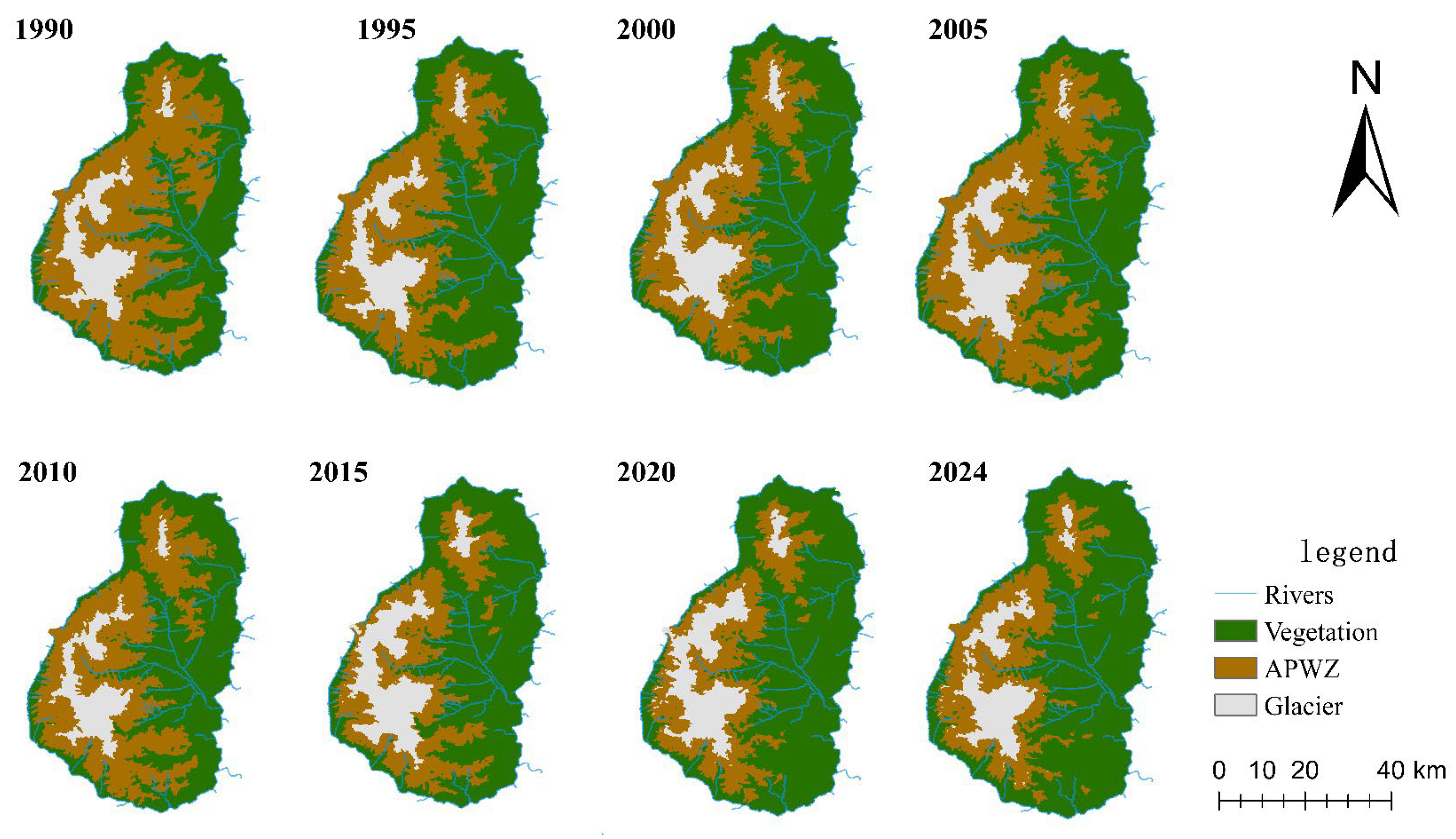
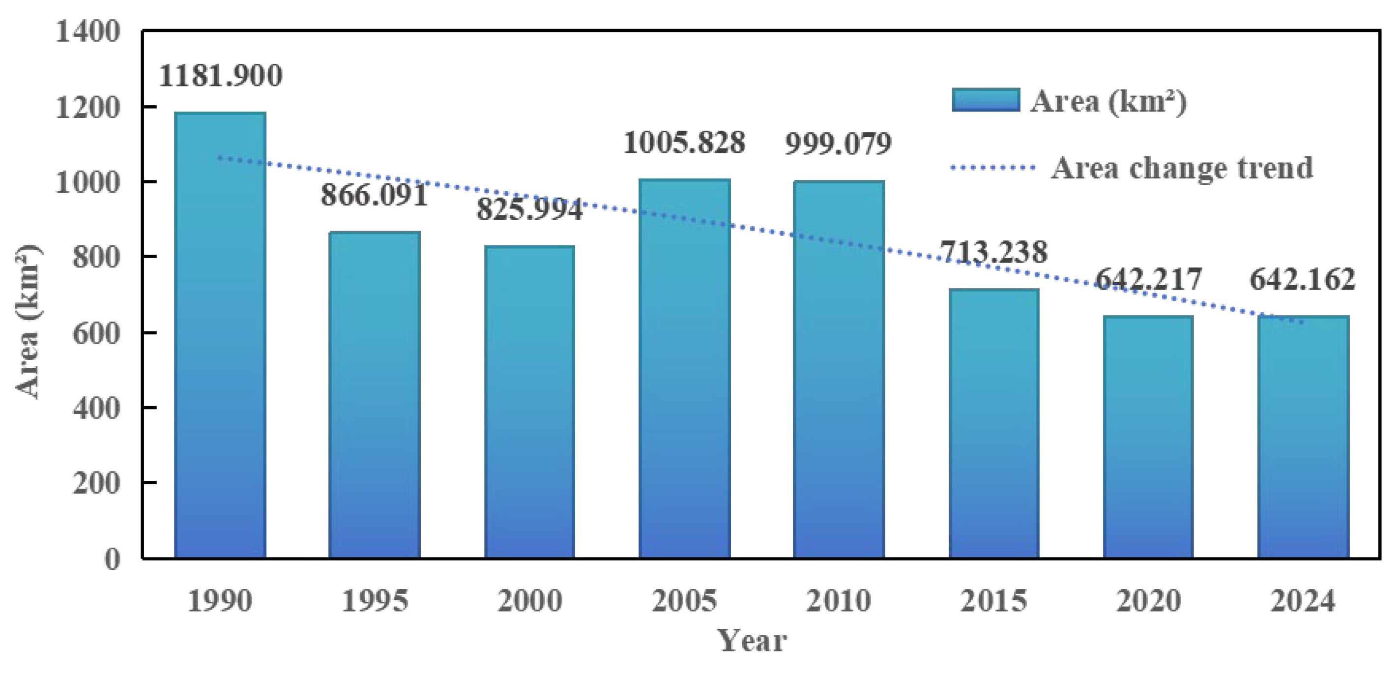
3.1. Extraction Results for the Alpine Periglacial Weathering Zone Based on Otsu Algorithm
- (1)
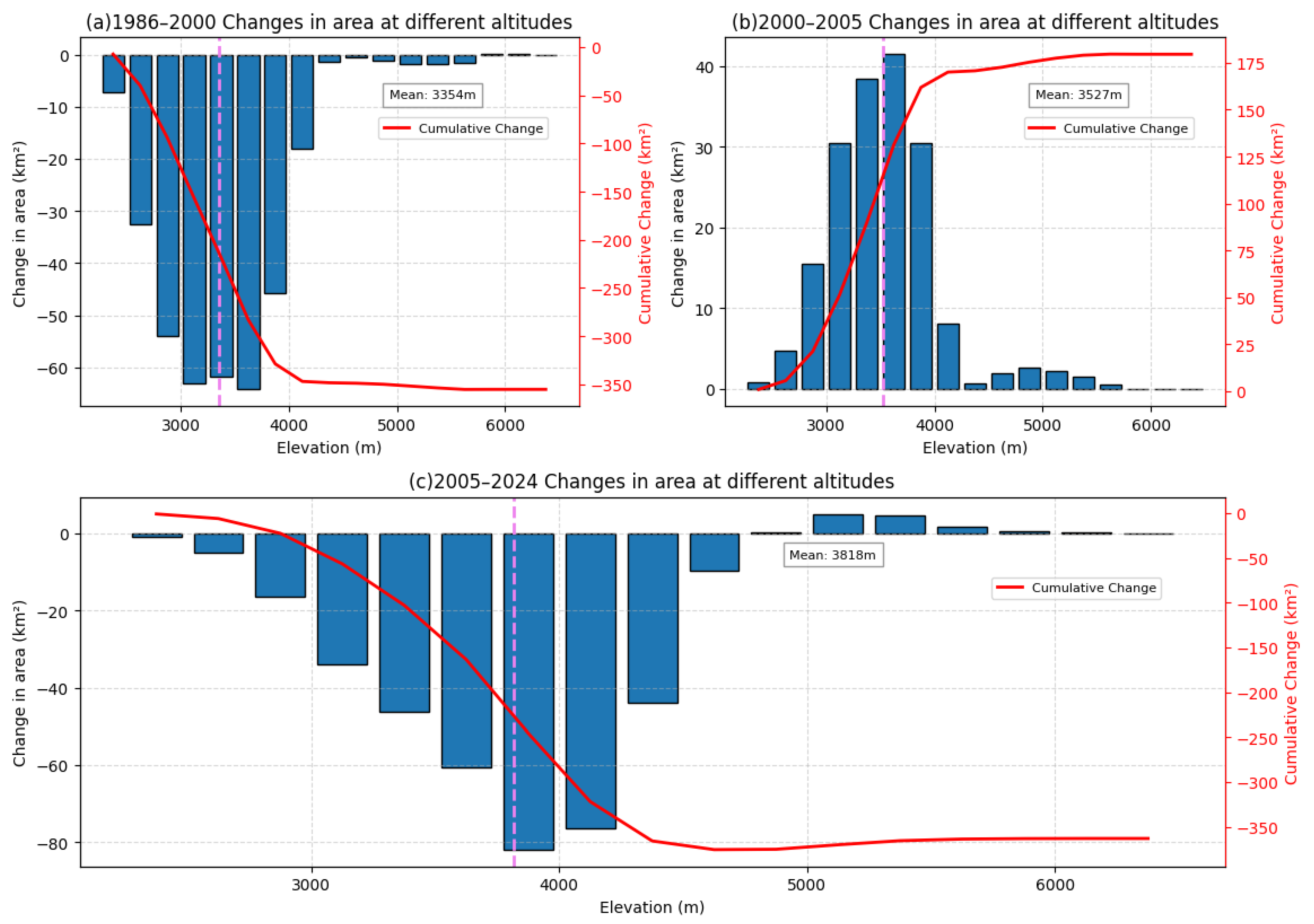
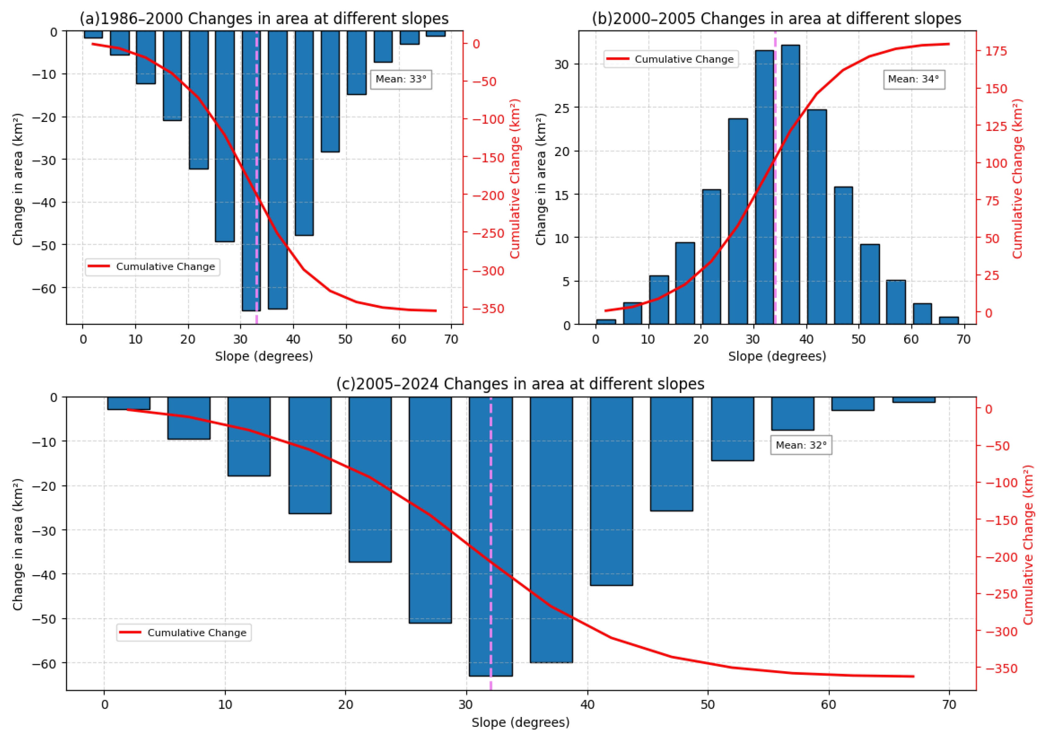
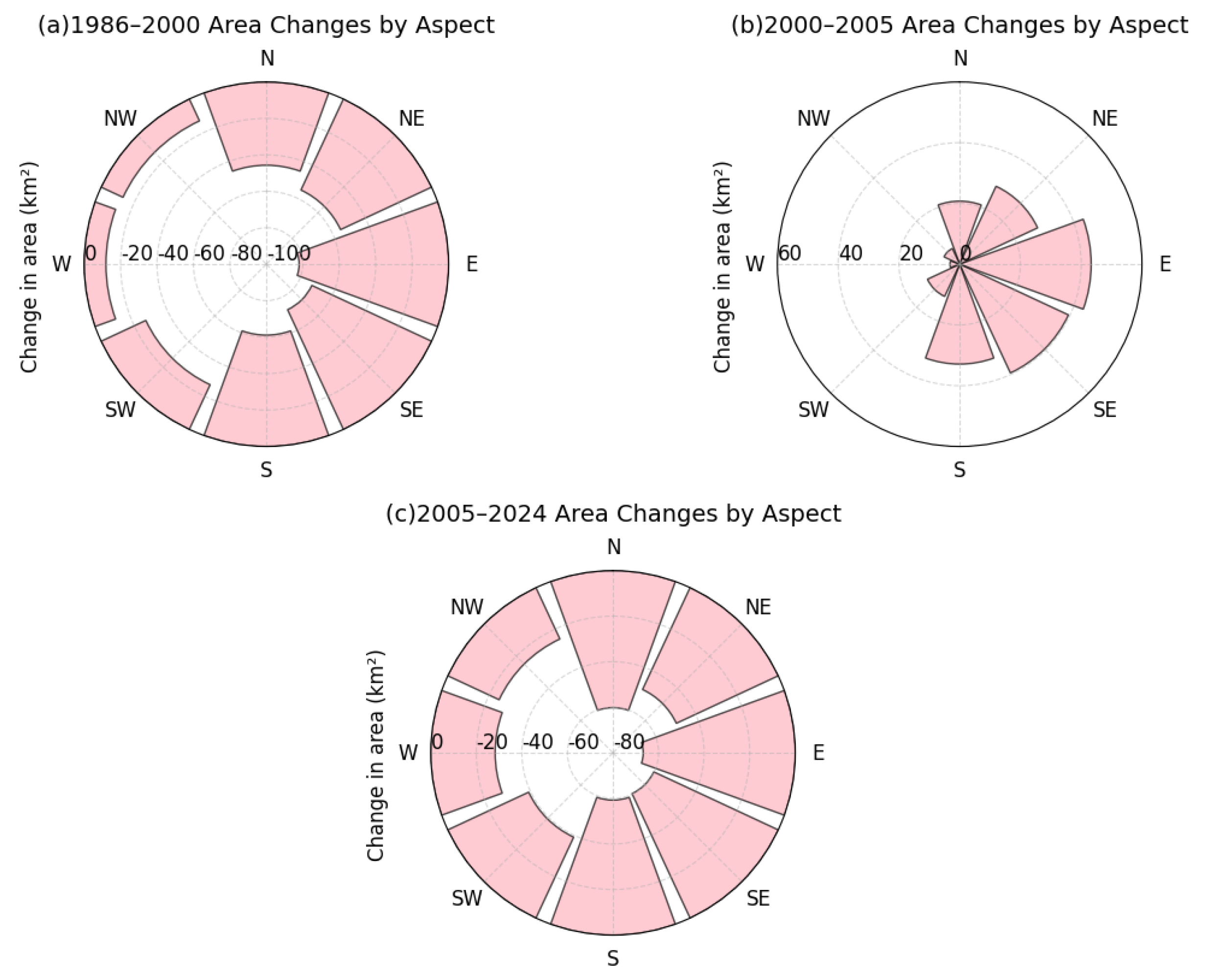
- 1986–2000: Rapid Shrinkage Phase.
- (2)
- 2000–2005: Short-Term Expansion Phase.
- (3)
- 2005–2024: Slow Shrinkage Phase.
3.2. Accuracy Assessment
3.3. Area Variations of the Alpine Periglacial Weathering Zone Under Different Topographic Conditions
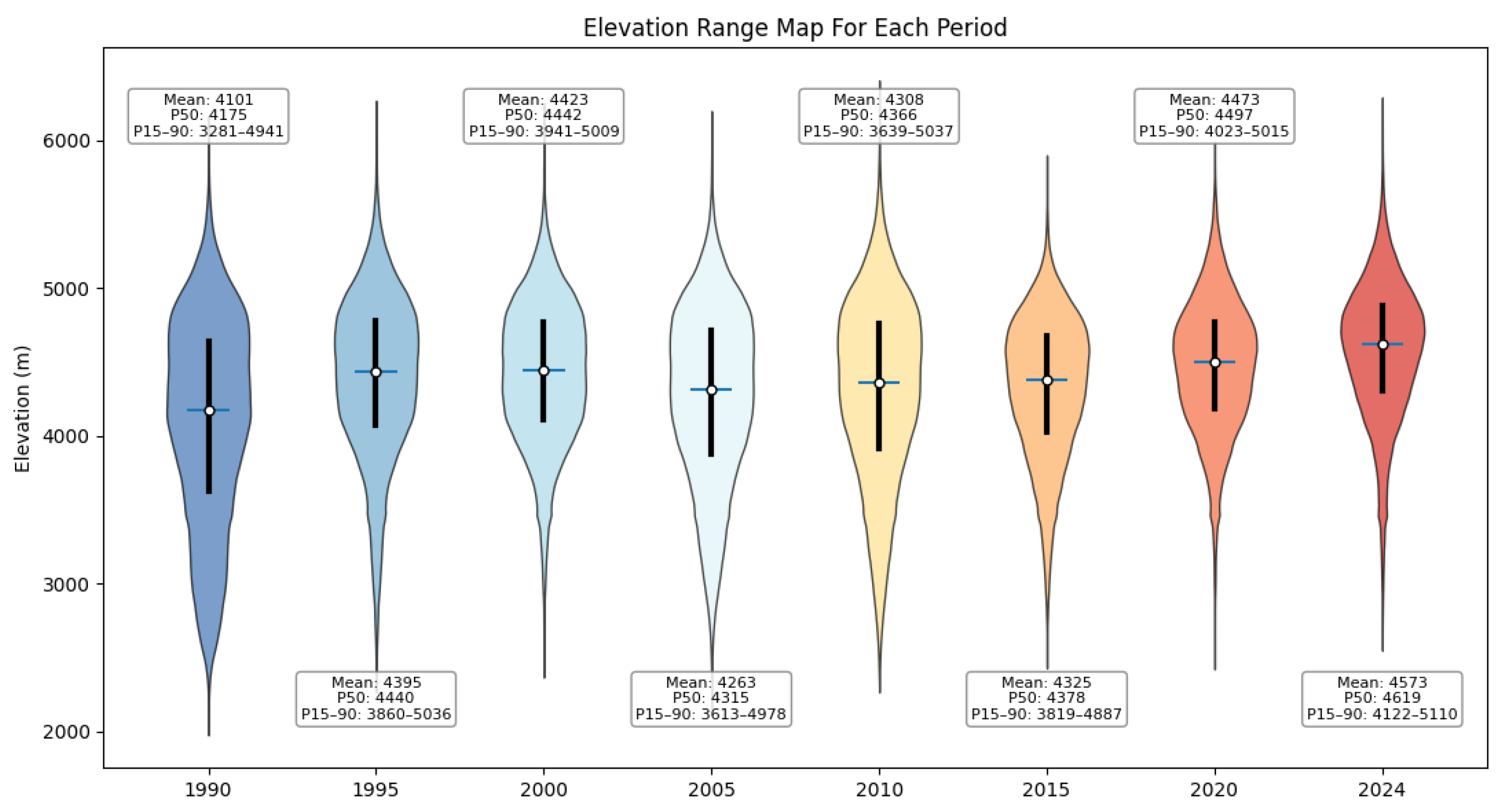
3.3.1. Variations Across Elevation Bands
3.3.2. Variations Across Slope Gradients
3.3.3. Variations Across Aspect Classes
3.4. Analysis of the Response of Alpine Periglacial Weathering Zone (APWZ) Dynamics to Climate Change and Topographic Factors
3.4.1. Response of APWZ Dynamics to Climate Change
3.4.2. Response of APWZ Dynamics to Topographic Factors
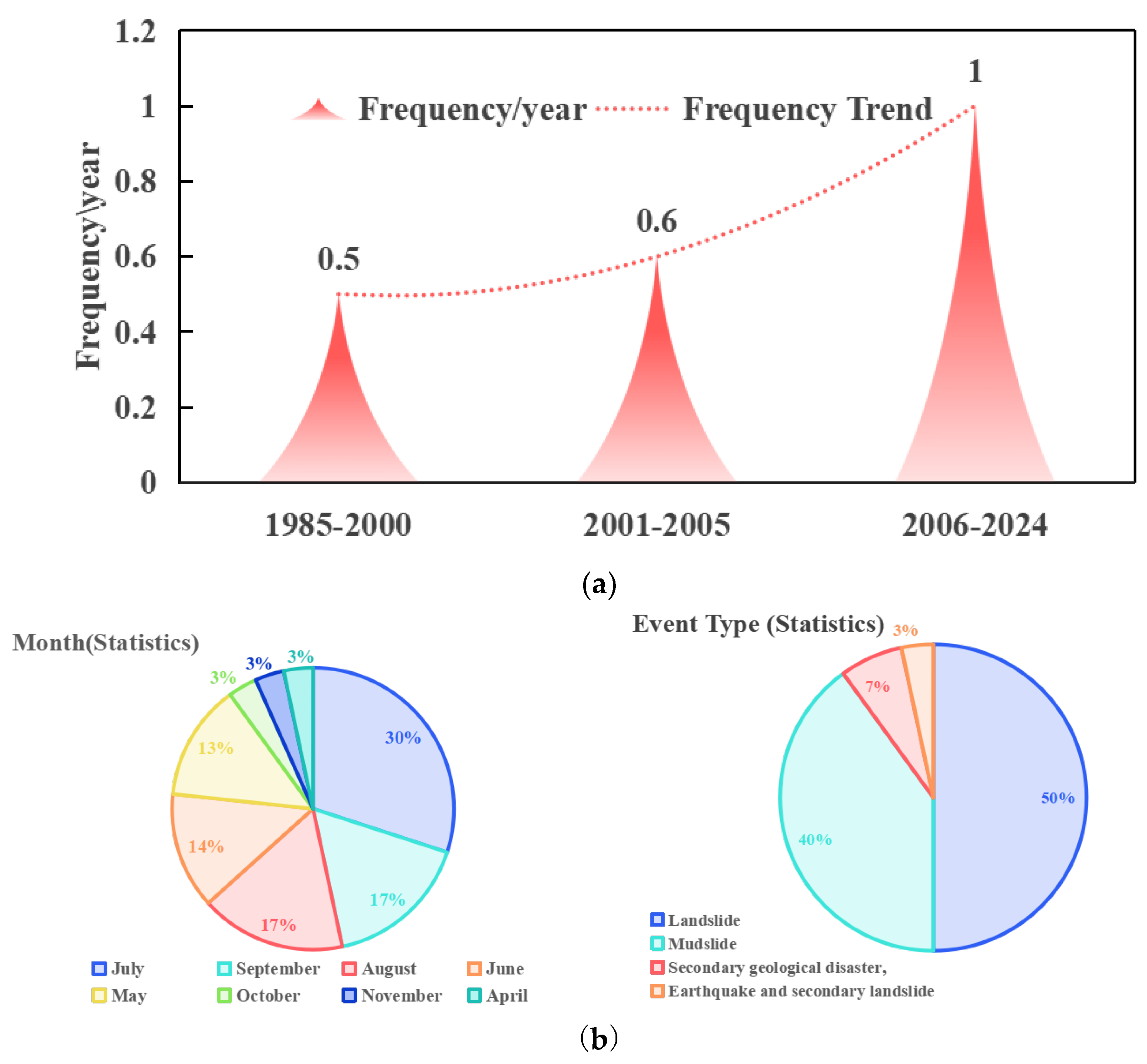
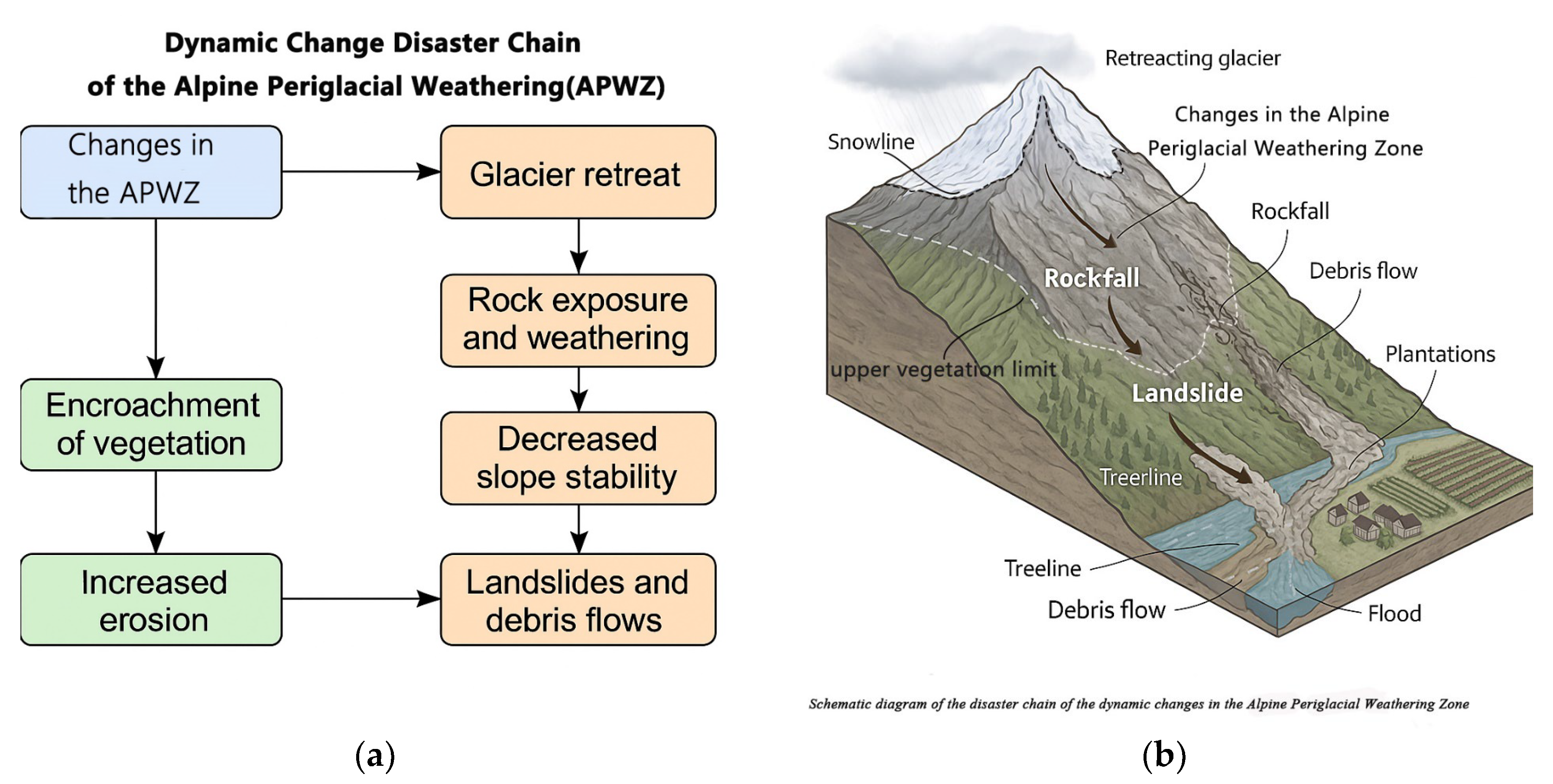
3.5. Hazard Responses to the Dynamics of the Alpine Periglacial Weathering Zone in the Gongga Mountain Region
4. Discussion
5. Conclusions
- (1)
- Methodological framework and validation: The proposed APWZ boundary extraction method—based on the fusion of NDVI/NDSI indices and Otsu algorithm—achieved high automation and timeliness on the GEE platform, demonstrating strong applicability and transferability. Comparison with the Second National Glacier Inventory showed an extraction error of 6.42% for glacier extent, corresponding to an overall accuracy of 93.58%. The snowline and vegetation upper limit boundaries were also validated against Sentinel-2 visual interpretations, yielding mean absolute errors of 45.37 m and 48 m, respectively, and R2 values of 0.96 for both. These results confirm the robustness and reliability of the method in complex alpine terrain.
- (2)
- Change characteristics: From 1986 to 2024, the APWZ in Gongga Mountain exhibited a persistent shrinking trend and overall upward migration. The mean elevation of the APWZ boundaries rose from 4101 m to 4575 m, with an average annual area loss of 13.84 km2. The change process can be divided into three phases: rapid shrinkage (1986–2000), brief expansion (2000–2005), and gradual shrinkage (2005–2024). The average annual uplift rates of the snowline and vegetation upper limit were 3.9 m and 17.43 m, respectively. The latter had a greater magnitude and played a dominant role in the reduction of APWZ area, highlighting the sensitivity of alpine vegetation to climate warming.
- (3)
- Dominant driving mechanisms: The evolution of the APWZ is co-driven by climatic and topographic factors. Temperature increase is the primary driver, promoting simultaneous upward movement of the snowline and vegetation limit, thereby compressing the vertical space of the weathering zone. Precipitation serves a regulatory role, indirectly influencing boundary fluctuations by affecting vegetation moisture conditions. Topographic factors shape the spatial heterogeneity of the response: elevation controls the migration trajectories of upper and lower boundaries; slope determines expansion potential; aspect regulates solar radiation and thermal accumulation. The most significant APWZ changes occurred at mid-high elevations (4200–4700 m), moderate slopes (25–35°), and sunny aspects, reflecting its spatial sensitivity to climate warming.
- (4)
- Disaster response mechanisms: The upward shift of the APWZ has substantially restructured the regional disaster-prone environment. Glacier retreat at the upper boundary exposes high-elevation bedrock, intensifying debris accumulation and slope instability. The lower boundary, characterized by nascent and fragile vegetation communities with shallow root systems, is vulnerable to disturbances. These conditions collectively form a typical chain-type hazard-prone pattern of “high-elevation sediment source–mid-slope deformation–low-elevation impact.” In recent years, the frequency of landslides and debris flows in the Gongga Mountain region has increased significantly, confirming the amplifying effect of APWZ changes on mountain disaster risks. The spatial dynamics of the APWZ have become a critical indicator for assessing mountain hazard chain initiation zones and triggering thresholds.
Author Contributions
Funding
Data Availability Statement
Acknowledgments
Conflicts of Interest
Abbreviations
| APWZ | Alpine Periglacial Weathering Zone |
| NDSI | Normalized Difference Snow Index |
| NDVI | Normalized Difference Vegetation Index |
| GEE | Google Earth Engine |
References
- Zheng, D.; Zhao, D. Characteristics of Natural Environment of the Tibetan Plateau. Sci. Technol. Rev. 2017, 35, 13–22. [Google Scholar]
- Xu, Y.; Zheng, D.; Li, K.; Gao, X. Edge Adaptation: A New Concept on Adapting to Climate Change. Adv. Clim. Chang. Res. 2013, 9, 376–378. [Google Scholar]
- Zhang, X.; Wu, J.; Wang, Y.; He, X.; Qi, Y. Vertical Geomorphologic Zonation in the Northwest Sichuan Plateau and Freezing Plantation Surface. J. Mt. Sci. 2006, 24, 607–611. [Google Scholar]
- Zhang, Y.; Li, L.; Ding, M.; Zheng, D. Greening of the Tibetan Plateau and Its Drivers Since 2000. Chin. J. Nat. 2018, 39, 173–178. [Google Scholar]
- Li, S.; Zhao, H.; Yu, W.; Yao, T.; Liu, S.; Wang, N.; Yang, W.; You, C.; Wang, W.; Wu, G.; et al. Glacier Anomalies and Relevant Disaster Risks on the Tibetan Plateau and Surroundings. Chin. Sci. Bull. 2019, 64, 2770–2782. [Google Scholar] [CrossRef]
- Yao, T.D.; Qin, D.H.; Shen, Y.P.; Zhao, L. Cryospheric Changes and Their Impacts on Regional Water Cycle and Ecological Conditions in the Qinghai-Tibetan Plateau. Chin. J. Nat. 2013, 35, 179–186. [Google Scholar]
- Liu, S.; Yao, X.; Guo, W.; Xu, J.; Shangguan, D.; Wei, J.; Bao, W.; Wu, L. The Contemporary Glaciers in China Based on the Second Chinese Glacier Inventory. Acta Geogr. Sin. 2015, 70, 3–16. [Google Scholar]
- Eichel, J.; Draebing, D.; Meyer, N. From Active to Stable: Paraglacial Transition of Alpine Lateral Moraine Slopes. Land Degrad. Dev. 2018, 29, 4158–4172. [Google Scholar] [CrossRef]
- Veh, G.; Korup, O.; Roessner, S.; Walz, A. Hazard from Himalayan Glacier Lake Outburst Floods. Proc. Natl. Acad. Sci. USA 2020, 117, 907–912. [Google Scholar] [CrossRef]
- Lu, J.; Yu, G.; Huang, H. Research and Prospect on Formation Mechanism of Debris Flows in High Mountains Under the Influence of Climate Change. J. Glaciol. Geocryol. 2021, 43, 555–567. [Google Scholar]
- Cui, P.; Guo, X.; Jiang, T.; Zhang, G.; Jin, W. Disaster Effect Induced by Asian Water Tower Change and Mitigation Strategies. Bull. Chin. Acad. Sci. 2017, 34, 1313–1321. [Google Scholar]
- Shugar, D.H.; Jacquemart, M.; Shean, D.; Bhushan, S.; Upadhyay, K.; Sattar, A.; Schwanghart, W.; McBride, S.; de Vries, M.V.W.; Mergili, M.; et al. A Massive Rock and Ice Avalanche Caused the 2021 Disaster at Chamoli, Indian Himalaya. Science 2021, 373, 300–306. [Google Scholar] [CrossRef]
- Zhou, Y.; Li, X.; Zheng, D.; Li, Z.; An, B.; Wang, Y.; Jiang, D.; Su, J.; Cao, B. The joint driving effects of climate and weather changes caused the Chamoli glacier-rock avalanche in the high altitudes of the India Himalaya. Sci. China Earth Sci. 2021, 64, 1909–1921. [Google Scholar] [CrossRef]
- Tielidze, L.G.; Nosenko, G.A.; Khromova, T.E.; Paul, F. Strong Acceleration of Glacier Area Loss in the Greater Caucasus Between 2000 and 2020. Cryosphere 2022, 16, 489–504. [Google Scholar] [CrossRef]
- Karma, K.; Namgay, T. Glacier Variation (Terminus & Surface Area) in Bhutan Himalaya from 1990–2020 as Deduced from Three Benchmark Glaciers (Shodng, Gangi La and Thana) and Their Relative Changes with Other Glaciers in the Himalaya. Bhutan Hydromet J. 2023, 2, 1–22. [Google Scholar]
- Azócar, G.F.; Brenning, A. Hydrological and geomorphological significance of rock glaciers in the dry Andes, Chile (27°–33° S). Permafr. Periglac. Process. 2010, 21, 42–53. [Google Scholar] [CrossRef]
- Fan, L.; Ji, F.; Kuang, X.; Guo, Z.; Zhang, R.; Zheng, C. Impacts of permafrost degradation on streamflow in the northern Himalayas. Sci. China Earth Sci. 2024, 67, 1990–2000. [Google Scholar] [CrossRef]
- Gottfried, M.; Pauli, H.; Futschik, A.; Akhalkatsi, M.; Barančok, P.; Benito Alonso, J.L.; Coldea, G.; Dick, J.; Erschbamer, B.; Fernández Calzado, M.R.; et al. Continent-Wide Response of Mountain Vegetation to Climate Change. Nat. Clim. Change 2012, 2, 111–115. [Google Scholar] [CrossRef]
- Fu, Z.; Zhan, Q.; Lenoir, J.; Wang, S.; Qian, H.; Yang, J.; Sun, W.; Mbuni, Y.M.; Ngumbau, V.M.; Hu, G.; et al. Climate Change Drives Plant Diversity Attrition at the Summit of Mount Kenya. New Phytol. 2025, 31. [Google Scholar] [CrossRef]
- Nie, Y.; Deng, Q.; Pritchard, H.D.; Carrivick, J.L.; Ahmed, F.; Huggel, C.; Liu, L.J.; Wang, W.; Lesi, M.; Liu, X.J.; et al. Glacial Lake Outburst Floods Threaten Asia’s Infrastructure. Sci. Bull. 2023, 68, 1361–1365. [Google Scholar] [CrossRef]
- Rehm, E.M.; Olivas, P.; Stroud, J.; Feeley, K.J. Losing Your Edge: Climate Change and the Conservation Value of Range-edge Populations. Ecol. Evol. 2015, 5, 4315–4326. [Google Scholar] [CrossRef]
- Sigdel, S.R.; Zheng, X.; Babst, F.; Camarero, J.J.; Gao, S.; Li, X.; Lu, X.; Pandey, J.; Dawadi, B.; Sun, J. Accelerated Succession in Himalayan Alpine Treelines under Climatic Warming. Nat. Plants 2024, 10, 1909–1918. [Google Scholar] [CrossRef]
- Couet, J.; Marjakangas, E.-L.; Santangeli, A.; Kålås, J.A.; Lindström, Å.; Lehikoinen, A. Short-Lived Species Move Uphill Faster under Climate Change. Oecologia 2022, 198, 877–888. [Google Scholar] [CrossRef] [PubMed]
- Yao, T.F.; Cao, S.Y.; Peng, F.; Li, C.S. Analysis of Plant Composition and Vegetation Community Characteristics at Different Succession Stages in the Glacier Retreat Area of Austre Lovénbreen, Ny-Ålesund, Arctic. Chin. J. Polar Res. 2014, 26, 3. [Google Scholar]
- Draebing, D.; Krautblatter, M. The Efficacy of Frost Weathering Processes in Alpine Rockwalls. Geophys. Res. Lett. 2019, 46, 6516–6524. [Google Scholar] [CrossRef]
- Ram, S.S.; Zhang, H.; Zhu, H.; Sher, M.; Liang, E. Retreating Glacier and Advancing Forest Over the Past 200 Years in the Central Himalayas. J. Geophys. Res. Biogeosciences 2020, 125, e2020JG005751. [Google Scholar] [CrossRef]
- Leng, S.Y. Thirty Years of Geographical Science: From Classics to the Frontiers; Commercial Press: Beijing, China, 2016. (In Chinese) [Google Scholar]
- Wei, B.; Zhang, Y.; Liu, L.; Zhang, B.; Gong, D.; Gu, C.; Li, L.; Paudel, B. Upper Elevational Limit of Vegetation in the Himalayas Identified from Landsat Images. Remote Sens. 2025, 17, 78. [Google Scholar] [CrossRef]
- Liu, L.; Chen, J.; Shen, M.; Chen, X.; Cao, R.; Cao, X.; Cui, X.; Yang, W.; Zhu, X.; Li, L.; et al. A Remote Sensing Method for Mapping Alpine Grasslines Based on Graph-Cut. Glob. Chang. Biol. 2023, 30, e17005. [Google Scholar] [CrossRef]
- Ruiz Fernández, J.; Oliva, M.; Hughes, P. Permafrost and Periglacial Processes in Mid- and Low-Latitude Mountain Regions. Permafr. Periglac. Process. 2019, 30, 245–248. [Google Scholar] [CrossRef]
- Runge, A.; Grosse, G. Mosaicking Landsat and Sentinel-2 Data to Enhance LandTrendr Time Series Analysis in Northern High Latitude Permafrost Regions. Remote Sens. 2020, 12, 15–2471. [Google Scholar] [CrossRef]
- Roy, D.P.; Li, J.; Zhang, H.K.; Yan, L.; Huang, H.; Li, Z. Examination of Sentinel-2A multi-spectral instrument (MSI) reflectance anisotropy and the suitability of a general method to normalize MSI reflectance to nadir BRDF adjusted reflectance. Remote Sens. Environ. 2017, 199, 25–38. [Google Scholar] [CrossRef]
- He, K.; Zhang, X.; Ren, S.; Sun, J. Deep Residual Learning for Image Recognition. In Proceedings of the 2016 IEEE Conference on Computer Vision and Pattern Recognition (CVPR), Las Vegas, NV, USA, 27–30 June 2016; pp. 770–778. [Google Scholar] [CrossRef]
- Niu, Y.; Zhang, H.; Han, W.; Zhang, L.; Chen, H. A Fixed-Threshold Method for Estimating Fractional Vegetation Cover of Maize under Different Levels of Water Stress. Remote Sens. 2021, 13, 1009. [Google Scholar] [CrossRef]
- Maarir, A.; Benyoucef, A.; Bouikhalene, B. Novel HSV Colour Space based Threshold Method for Vegetation Extraction and its Performance on Landsat TM Images. Int. J. Eng. Technol. 2018, 7, 25–29. [Google Scholar] [CrossRef]
- Cao, B.; Wang, J.; Zhang, C.; Zhang, G.L.; Pan, B.T. The Remote Sensing in Research of Modern Glacier Changes. Remote Sens. Technol. Appl. 2011, 26, 52–59. [Google Scholar] [CrossRef]
- Xia, C.F.; Li, J.; Liu, Q.H. Review of advances in vegetation phenology monitoring by remote sensing. J. Remote Sens. 2013, 17, 1–16. [Google Scholar]
- Wang, S.H.; Ke, C.Q.; Chen, J. Semi-Automatic Update of the Second Chinese Glacier Inventory Based on Deep Learning. Remote Sens. Technol. Appl. 2023, 38, 1264–1273. [Google Scholar]
- Kang, S.; Xu, Y.; You, Q.; Flügel, W.A.; Pepin, N.; Yao, T. Review of Climate and Cryospheric Change in the Tibetan Plateau. Environ. Res. Lett. 2009, 5, 015101. [Google Scholar] [CrossRef]
- Tian, M.Q.; Duan, K.Q.; Shi, P.H. Glacier changes on the Qinghai-Tibet Plateau based on Google Earth Engine: A case study of the Purog Kangri glacier. Sci. Geogr. Sin. 2023, 43, 943–951. [Google Scholar] [CrossRef]
- Zhu, D.; Peng, S.S.; Ciais, P.; Viovy, N.; Druel, A.; Kageyama, M.; Krinner, G.; Peylin, P.; Ottlé, C.; Piao, S.L.; et al. Improving the dynamics of Northern Hemisphere high-latitude vegetation in the ORCHIDEE ecosystem model. Geosci. Model Dev. 2015, 8, 2263–2283. [Google Scholar] [CrossRef]
- Carrasco, L.; O’Neil, A.W.; Daniel Morton, R.; Rowland, C.S. Evaluating combinations of temporally aggregated Sentinel-1, Sentinel-2 and Landsat 8 for land cover mapping with Google Earth Engine. Remote Sens. 2019, 11, 288. [Google Scholar] [CrossRef]
- Jiao, J.; Shi, J.; Tian, Q.; Gao, L.; Xu, N. Research on Multispectral-Image-Based NDVI Shadow-Effect-Eliminating Model. J. Remote Sens. 2020, 24, 53–66. [Google Scholar] [CrossRef]
- Otsu, N. A Threshold Selection Method from Gray-Level Histograms. IEEE Trans. Syst. Man Cybern. 1979, 9, 62–66. [Google Scholar] [CrossRef]
- Vala, H.J.; Baxi, A. A Review on Otsu Image Segmentation Algorithm. 2013. Available online: https://api.semanticscholar.org/CorpusID:62421994 (accessed on 25 March 2025).
- Donchyts, G.; Schellekens, J.; Winsemius, H.; Eisemann, E.; van de Giesen, N. A 30 m Resolution Surface Water Mask Including Estimation of Positional and Thematic Differences Using Landsat 8, SRTM and OpenStreetMap: A Case Study in the Murray-Darling Basin, Australia. Remote Sens. 2016, 8, 386. [Google Scholar] [CrossRef]
- Rad, A.M.; Kreitler, J.; Sadegh, M. Augmented Normalized Difference Water Index for improved surface water monitoring. Environ. Model. Softw. 2021, 140, 105030. [Google Scholar] [CrossRef]
- Li, B.; Xu, X.; Han, J.; Zhang, L.; Bian, C.; Jin, L.; Liu, J. The estimation of crop emergence in potatoes by UAV RGB imagery. Plant Methods 2019, 15, 15. [Google Scholar] [CrossRef]
- Yu, Y.; Bao, Y.; Wang, J.; Chu, H.; Zhao, N.; He, Y.; Liu, Y. Crop Row Segmentation and Detection in Paddy Fields Based on Treble-Classification Otsu and Double-Dimensional Clustering Method. Remote Sens. 2021, 13, 901. [Google Scholar] [CrossRef]
- Li, C.; Shao, Z.; Zhang, L.; Huang, X.; Zhang, M. A Comparative Analysis of Index-Based Methods for Impervious Surface Mapping Using Multiseasonal Sentinel-2 Satellite Data. IEEE J. Sel. Top. Appl. Earth Obs. Remote Sens. 2021, 14, 3682–3694. [Google Scholar] [CrossRef]
- Pekel, J.-F.; Cottam, A.; Gorelick, N.; Belward, A.S. High-Resolution Mapping of Global Surface Water and Its Long-Term Changes. Nature 2016, 540, 418–422. [Google Scholar] [CrossRef]
- He, Y. Glacier Extraction and Evolution Analysis Based on Multispectral Remote Sensing and Cloud Platform. Master’s Thesis, Chengdu University of Technology, Chengdu, China, 2022. [Google Scholar]
- Liu, W.G.; Li, Y.; Yang, C. Research on Edge Detection Algorithms for Grassland Images. Comput. Sci. Appl. 2017, 5, 457–462. [Google Scholar] [CrossRef]
- Li, Z.J.; Wang, N.L.; Chen, A.A.; Liu, K. Remote sensing monitoring of glacier changes in Shyok basin of the Karakoram Mountains, 1993–2016. J. Glaciol. Geocryol. 2019, 41, 770–782. [Google Scholar]
- Ameztegui, A.; Coll, L.; Brotons, L.; Ninot, J.M. Land-Use Legacies Rather Than Climate Change Are Driving the Recent Upward Shift of the Mountain Tree Line in the Pyrenees. Glob. Ecol. Biogeogr. 2016, 25, 263–273. [Google Scholar] [CrossRef]
- Zhou, S.; Sun, Z.; Sun, P. Rapid Glacier Shrinkage in the Gongga Mountains in the Last 27 Years. Remote Sens. 2022, 14, 5397. [Google Scholar] [CrossRef]
- Ponti, S.; Cannone, N.; Guglielmin, M. A New Simple Topo-Climatic Model to Predict Surface Displacement in Paraglacial and Periglacial Mountains of the European Alps: The Importance of Ground Heating Index and Floristic Components as Ecological Indicators. Ecol. Indic. 2020, 120, 106889. [Google Scholar] [CrossRef]
- Guo, C.; Wu, R.; Zhang, Y.; Ren, S.; Yang, Z.; Li, X. Characteristics and Formation Mechanism of Giant Long-Runout Landslide: A Case Study of the Gamisi Ancient Landslide in the Upper Minjiang River, China. Acta Geol. Sin. 2019, 93, 1113–1124. [Google Scholar] [CrossRef]
- Knizhnikov, Y.; Kravtsova, V.; Labutina, I. Cartographic Remote-Sensing Monitoring of Glaciological Systems (Example, Mount El’brus, U.S.S.R.). Ann. Glaciol. 1987, 9, 247–248. [Google Scholar] [CrossRef]
- Carcaillet, C.; Blarquez, O. Glacial Refugia in the South-Western Alps? New Phytol. 2019, 222, 663–667. [Google Scholar] [CrossRef] [PubMed]
- Formica, A.; Farrer, E.; Ashton, I.; Suding, K. Shrub Expansion Over the Past 62 Years in Rocky Mountain Alpine Tundra: Possible Causes and Consequences. Arct. Antarct. Alp. Res. 2014, 46, 616–631. [Google Scholar] [CrossRef]
- Cao, H.; Dong, G. Social Development and Living Environment Changes in the Northeast Tibetan Plateau and Contiguous Regions During the Late Prehistoric Period. Reg. Sustain. 2020, 1, 59–67. [Google Scholar] [CrossRef]
- Dudová, L.; Hájek, M.; Petr, L.; Jankovská, V. Holocene Vegetation History of the Jeseníky Mts: Deepening Elevational Contrast in Pollen Assemblages Since Late Prehistory. J. Veg. Sci. 2018, 29, 371–381. [Google Scholar] [CrossRef]
- Han, C.; Chen, R.; Liu, J.; Yang, Y.; Liu, Z.W. Hydrological Characteristics in Non-Freezing Period at the Alpine Desert Zone of Hulugou Watershed, Qilian Mountains. J. Glaciol. Geocryol. 2013, 35, 1536–1544. [Google Scholar]
- Chifflard, P.; Blume, T.; Maerker, K.; Hopp, L.; van Meerveld, I.; Graeff, T.; Gronz, O.; Hartmann, A.; Kohl, B.; Martini, E.; et al. How can we model subsurface stormflow at the catchment scale if we cannot measure it? Hydrol. Process. 2019, 33, 1378–1385. [Google Scholar] [CrossRef]
- Taschler, D.; Neuner, G. Summer frost resistance and freezing patterns measured in situ in leaves of major alpine plant growth forms in relation to their upper distribution boundary. Plant Cell Environ. 2004, 27, 737–746. [Google Scholar] [CrossRef]
- Chamberlain, D.; Arlettaz, R.; Caprio, E.; Maggini, R.; Pedrini, P.; Rolando, A.; Zbinden, N. The Altitudinal Frontier in Avian Climate Impact Research. Ibis 2011, 154, 205–209. [Google Scholar] [CrossRef]
- Chen, I.-C.; Hill, J.K.; Ohlemüller, R.; Roy, D.B.; Thomas, C.D. Rapid Range Shifts of Species Associated with High Levels of Climate Warming. Science 2011, 333, 1024–1026. [Google Scholar] [CrossRef] [PubMed]
- Kullman, L. Rapid Recent Range-Margin Rise of Tree and Shrub Species in the Swedish Scandes. J. Ecol. 2002, 90, 68–77. [Google Scholar] [CrossRef]
- Hock, R. Glacier Melt: A Review of Processes and Their Modelling. Prog. Phys. Geogr. 2005, 29, 362–391. [Google Scholar] [CrossRef]
- Hendrick, R.; Filgate, B.; Adams, W. Application of Environmental Analysis to Watershed Snowmelt. J. Appl. Meteorol. 1971, 10, 418–429. [Google Scholar] [CrossRef]
- Körner, C. A Re-Assessment of High Elevation Treeline Positions and Their Explanation. Oecologia 1998, 115, 445–459. [Google Scholar] [CrossRef]
- Webb, R.; Litvak, M.; Brooks, P. The Role of Terrain-Mediated Hydroclimate in Vegetation Recovery After Wildfire. Environ. Res. Lett. 2023, 18, 064036. [Google Scholar] [CrossRef]
- Lenoir, J.; Gégout, J.C.; Marquet, P.A.; De Ruffray, P.; Brisse, H. A Significant Upward Shift in Plant Species Optimum Elevation During the 20th Century. Science 2008, 320, 1768–1771. [Google Scholar] [CrossRef]
- Matsuoka, N. Frost Weathering and Rockwall Erosion in the Southeastern Swiss Alps: Long-Term (1994–2006) Observations. Geomorphology 2008, 99, 353–368. [Google Scholar] [CrossRef]
- Kumar, S.; Khanduri, V.P. Impact of climate change on the Himalayan alpine treeline vegetation. Heliyon 2024, 10, e40797. [Google Scholar] [CrossRef]
- He, G.; Luo, J.; Gu, H. Effects of Climate Change on Temperature Sensitivity of Vegetation Growth in Huang-Huai-Hai Plain. Remote Sens. 2024, 16, 4024. [Google Scholar] [CrossRef]
- Lutz, J.; Wagtendonk, J.; Franklin, J. Climatic Water Deficit, Tree Species Ranges, and Climate Change in Yosemite National Park. J. Biogeogr. 2010, 37, 936–950. [Google Scholar] [CrossRef]
- Wang, Z.; Hu, K.-H.; Ma, C.; Li, Y.; Liu, S. Landscape Change in Response to Multiperiod Glacial Debris Flows in Peilong Catchment, Southeastern Tibet. J. Mt. Sci. 2021, 18, 567–582. [Google Scholar] [CrossRef]
- Huggel, C.; Khabarov, N.; Korup, O.; Obersteiner, M. Physical Impacts of Climate Change on Landslide Occurrence and Related Adaptation. In Landslides: Types, Mechanisms and Modeling; Clague, J.J., Stead, D., Eds.; Cambridge University Press: Cambridge, UK, 2012; pp. 121–133. [Google Scholar]
- Zhong, Y.; Liu, Q.; Westoby, M.; Nie, Y.; Pellicciotti, F.; Zhang, B.; Cai, J.; Liu, G.; Liao, H.; Lu, X. Intensified Paraglacial Slope Failures Due to Accelerating Downwasting of a Temperate Glacier in Mt. Gongga, Southeastern Tibetan Plateau. Earth Surf. Dyn. 2022, 10, 23. [Google Scholar] [CrossRef]
- Kääb, A.; Jacquemart, M.; Gilbert, A.; Leinss, S.; Girod, L.; Huggel, C.; Falaschi, D.; Ugalde, F.; Petrakov, D.; Chernomorets, S.; et al. Sudden Large-Volume Detachments of Low-Angle Mountain Glaciers–More Frequent Than Thought? Cryosphere 2021, 15, 1751–1785. [Google Scholar] [CrossRef]
- Hewitt, K.; Clague, J.; Deline, P. Catastrophic Rock Slope Failures and Mountain Glaciers. In Encyclopedia of Snow, Ice and Glaciers; Singh, V.P., Singh, P., Haritashya, U.K., Eds.; Springer: Dordrecht, The Netherlands, 2011; pp. 113–126. [Google Scholar] [CrossRef]
- Zhao, W.; Li, H.; Zhang, S.; Liu, J. Linking Glacier Retreat with Climate Change on the Tibetan Plateau. Cryosphere 2024, 18, 5595–5610. [Google Scholar] [CrossRef]
- Barwal, A.; Sood, A. Eco-Restoration for Climate Resilience and Disaster Risk Reduction. In Ecosystem Restoration: Towards Sustainability and Resilient Development; Gupta, A.K., Goyal, M.K., Singh, S.P., Eds.; Springer: Singapore, 2023; pp. 1–15. [Google Scholar] [CrossRef]
- Pan, B.; Zhang, G.; Wang, J.; Cao, B.; Wang, J.; Zhang, C.; Geng, H.; Ji, Y. Glacier Changes from 1966–2009 in the Gongga Mountains, on the South-Eastern Margin of the Qinghai-Tibetan Plateau and Their Climatic Forcing. Cryosphere Discuss 2011, 5, 3479–3516. [Google Scholar] [CrossRef]
- He, W.; Ye, C.; Sun, J.; Xiong, J.; Wang, J.; Zhou, T. Dynamics and Drivers of the Alpine Timberline on Gongga Mountain of Tibetan Plateau-Adopted from the Otsu Method on Google Earth Engine. Remote Sens. 2020, 12, 2651. [Google Scholar] [CrossRef]
- Zhu, W.Z.; Ran, F.; Li, M.H.; Wang, W.Z.; Jia, M. Alpine Timberline Dynamics and Physiological Mechanisms of the Timberline Formation on the Mt. Gongga. J. Mt. Sci. 2017, 35, 622–628. [Google Scholar]
- Kosiński, P.; Sękiewicz, K.; Walas, Ł.; Boratyński, A.; Dering, M. Spatial Genetic Structure of the Endemic Alpine Plant Salix serpillifolia: Genetic Swamping on Nunataks Due to Secondary Colonization? Alp. Bot. 2019, 129, 107–121. [Google Scholar] [CrossRef]
- Tuft, K.T.; Tuft, T.; Davies, K.F. A Framework for Integrating Thermal Biology into Fragmentation Research. Ecol. Lett. 2016, 19, 361–374. [Google Scholar] [CrossRef]
- Cornacchia, L.; van de Koppel, J.; van der Wal, D.; Wharton, G.; Puialon, S.; Bouma, T.J. Landscapes of Facilitation: How Self-Organized Patchiness of Aquatic Macrophytes Promotes Diversity in Streams. Ecology 2018, 99, 832–847. [Google Scholar] [CrossRef] [PubMed]
- Wei, X.; Shen, Y.J.; Ning, Y.B.; Wang, Y.; Zhan, J.W.; Li, X.T. Research Progress on Formation Process, Soil-Forming Characteristics, and Landslide Disaster Mechanism of Moraine in High-Mountain Glacier Regions. J. Eng. Geol. 2024, 32, 947–962. [Google Scholar] [CrossRef]
- Mourey, J.; Ravanel, L.; Lambiel, C. Climate Change Related Processes Affecting Mountaineering Itineraries, Mapping and Application to the Valais Alps (Switzerland). Geogr. Ann. Ser. A Phys. Geogr. 2022, 104, 109–126. [Google Scholar] [CrossRef]
- Wang, Z.; Liu, K.; Cao, J.; Peng, L.; Wen, X. Annual Change Analysis of Mangrove Forests in China during 1986–2021 Based on Google Earth Engine. Forests 2022, 13, 1489. [Google Scholar] [CrossRef]
- Tian, F.; Wu, B.; Zeng, H.; Zhang, X.; Xu, J. Efficient Identification of Corn Cultivation Area with Multitemporal Synthetic Aperture Radar and Optical Images in the Google Earth Engine Cloud Platform. Remote Sens. 2019, 11, 629. [Google Scholar] [CrossRef]
- Gorelick, N.; Hancher, M.; Dixon, M.; Ilyushchenko, S.; Thau, D.; Moore, R. Google Earth Engine: Planetary-Scale Geospatial Analysis for Everyone. Remote Sens. Environ. 2017, 202, 18–27. [Google Scholar] [CrossRef]
- Qadir, A.; Mondal, P. Synergistic Use of Radar and Optical Satellite Data for Improved Monsoon Cropland Mapping in India. Remote Sens. 2020, 12, 522. [Google Scholar] [CrossRef]


| Data Types | Data Source Unit | Data Name | Spatial Resolution | Time Range | Remark |
|---|---|---|---|---|---|
| Remote sensing images * | United States Geological Survey (USGS) | Landsat 5 TM/Landsat 8 OLI | 30 m | 1986–2024 | Summer, cloud cover <10%, 5-year interval |
| Copernicus Open Access Hub | Sentinel-2 | 10 m | 2 August 2021 | Cloud cover <5% | |
| Climate data * | National Ecological Science Data Center | Monthly mean temperature and precipitation | Point Data | 1998–2018 | Gongga Mountain area, summer |
| Digital Elevation Model | NASA | ASTER GDEM V3 | 30 m | - | Corrected version, higher precision |
| Glacier data | National Glacier, Frozen and Desert Data Center | The Second National Glacier Resources Survey | - | 2006–2011 | Gongga Glacier |
| Disaster data | Data Center for Resources and Environmental Sciences of the Chinese Academy of Sciences and Field Collection | Geological Hazards Dataset | - | 1985–2024 | - |
| Water body data | EC JRC/Google | JRC Monthly Water Recurrence, v1.4 | - | 1984–2021 | - |
| Year | Month | Type of Incident | Specific Location | Description |
|---|---|---|---|---|
| 1985 | July | Landslide | North slope of Gongga Mountain | Landslide caused by heavy rainfall blocked the climbing route and affected the travel of mountaineers. |
| 1988 | June | Landslide | South slope of Gongga Mountain | Spring snowmelt led to landslides, blocking part of the climbing route to Gongga Mountain. |
| 1991 | August | Mudslide | Luding County (near Luding Bridge) | Heavy rainfall triggered a mudslide, affecting traffic near Luding Bridge and causing casualties. |
| …… | …… | …… | …… | …… |
| 2019 | August | Mudslides | Hailougou Scenic Area | Heavy rainfall triggered mudslides, which damaged much infrastructure in the scenic area and threatened the safety of tourists. |
| 2021 | June | Landslides | Eastern slope of Gongga Mountain (near Yanzigou) | Landslide near Yanzigou led to the evacuation of tourists and some roads in the scenic area needed to be repaired. |
| 2022 | September | Earthquake and secondary landslides | Luding County and surrounding areas | Secondary landslides and mudslides triggered by a 6.8-magnitude earthquake destroyed many roads in Luding and Shimian and disrupted communications. |
| 2023 | June | Landslides | Gongga Mountain Scenic Area (near Base Camp) | Heavy rainfall led to landslides, mountain climbing routes were blocked and tourists were forced to evacuate. |
| 2024 | May | Landslide | South slope of Gongga Mountain | Spring snowmelt combined with rainfall triggered landslides, affecting climbing routes and some roads in the area. |
| 2024 | July | Mudslide | Eastern part of Kangding City, near Erlang Mountain | Heavy rainfall triggered mudslides, resulting in severe damage to the road from Kangding to Luding. |
Disclaimer/Publisher’s Note: The statements, opinions and data contained in all publications are solely those of the individual author(s) and contributor(s) and not of MDPI and/or the editor(s). MDPI and/or the editor(s) disclaim responsibility for any injury to people or property resulting from any ideas, methods, instructions or products referred to in the content. |
© 2025 by the authors. Licensee MDPI, Basel, Switzerland. This article is an open access article distributed under the terms and conditions of the Creative Commons Attribution (CC BY) license (https://creativecommons.org/licenses/by/4.0/).
Share and Cite
Zhang, Q.; Zhou, Q.; Liu, F.; Ma, W.; Chen, Q.; Wei, B.; Li, L.; Zhi, Z. Progressive Shrinkage of the Alpine Periglacial Weathering Zone and Its Escalating Disaster Risks in the Gongga Mountains over the Past Four Decades. Remote Sens. 2025, 17, 2462. https://doi.org/10.3390/rs17142462
Zhang Q, Zhou Q, Liu F, Ma W, Chen Q, Wei B, Li L, Zhi Z. Progressive Shrinkage of the Alpine Periglacial Weathering Zone and Its Escalating Disaster Risks in the Gongga Mountains over the Past Four Decades. Remote Sensing. 2025; 17(14):2462. https://doi.org/10.3390/rs17142462
Chicago/Turabian StyleZhang, Qiuyang, Qiang Zhou, Fenggui Liu, Weidong Ma, Qiong Chen, Bo Wei, Long Li, and Zemin Zhi. 2025. "Progressive Shrinkage of the Alpine Periglacial Weathering Zone and Its Escalating Disaster Risks in the Gongga Mountains over the Past Four Decades" Remote Sensing 17, no. 14: 2462. https://doi.org/10.3390/rs17142462
APA StyleZhang, Q., Zhou, Q., Liu, F., Ma, W., Chen, Q., Wei, B., Li, L., & Zhi, Z. (2025). Progressive Shrinkage of the Alpine Periglacial Weathering Zone and Its Escalating Disaster Risks in the Gongga Mountains over the Past Four Decades. Remote Sensing, 17(14), 2462. https://doi.org/10.3390/rs17142462