Review

Applications and Advancements of Spaceborne InSAR in Landslide Monitoring and Susceptibility Mapping: A Systematic Review

1
Suzhou Industrial Park Monash Research Institute of Science and Technology, Monash University, Suzhou 215000, China
2
Department of Civil Engineering, Monash University, 23 College Walk, Clayton, VIC 3800, Australia
3
Department of Civil Engineering, Xi’an Jiaotong-Liverpool University, Suzhou 215123, China
4
School of Civil Engineering, Southeast University, Nanjing 211189, China
*
Author to whom correspondence should be addressed.
Remote Sens. 2025, 17(6), 999; https://doi.org/10.3390/rs17060999
Submission received: 14 January 2025 / Revised: 4 March 2025 / Accepted: 10 March 2025 / Published: 12 March 2025

Abstract

:
Landslides pose significant threats to human safety and socio-economic development. In recent decades, interferometric synthetic aperture radar (InSAR) technology has emerged as a powerful tool for investigating landslides. This study systematically reviews the applications of spaceborne InSAR in landslide monitoring and susceptibility mapping over the past decade. We highlight advancements in key areas, including atmospheric delay correction, 3D landslide monitoring, failure time prediction, enhancements in spatial and temporal resolution, and integration with other technologies like the Global Navigation Satellite System (GNSS) and physical models. Additionally, we summarize various InSAR application strategies in landslide susceptibility mapping, identifying a gap between the static nature of most current studies and InSAR’s dynamic potential for capturing deformation velocity. Future research should integrate InSAR-derived factors with other dynamic variables like rainfall and soil moisture for dynamic susceptibility mapping and prediction. We also emphasize that further development of dynamic InSAR will require more efficient SAR data management and processing strategies.

Graphical Abstract

1. Introduction

Landslide refers to the movement of rock, earth, or debris down a slope due to gravity, often triggered by rainfall, earthquakes, volcanic activity, or human actions [1]. According to the 2022 Global Natural Disaster Assessment Report [2], landslides accounted for 5.3% of all natural disaster events, with a decline in frequency, deaths, affected population, and economic losses compared to the 30-year average. Despite these reductions, the threat of massive landslides to life and property remains significant and non-negligible. For instance, during the preparation of this review, a landslide event in Enga Province, Papua New Guinea, on 27 May 2024, resulted in approximately 670 people missing [3]. In the context of global climate change, implementing landslide monitoring and creating landslide susceptibility maps are crucial for managing landslide risks and disaster reduction. This approach not only aligns with the Sendai Framework for Disaster Risk Reduction 2015–2030 goal of reducing existing disaster risk [4] but also contributes to achieving the United Nations’ Sustainable Development Goals (SDGs), particularly SDG 11 (Sustainable Cities and Communities) and SDG 13 (Climate Action) [5].
Deformation monitoring is a crucial approach for the effective identification and quantitative assessment of landslide movements. Conventional monitoring methods, such as the global navigation satellite system (GNSS) [6,7,8] and geotechnical sensors [9,10,11], are widely employed. Despite providing high precision at specific points, they have considerable limitations, such as restricted spatial coverage with sparse measurement points and deployment challenges in remote mountainous regions with steep slopes resulting from the expense and difficulty of access. Over the past few decades, the proliferation of satellite remote sensing techniques has demonstrated its substantial capability in offering a comprehensive perspective often unattainable by ground-based methods. Optical remote sensing and synthetic aperture radar (SAR) are the primary remote sensing platforms employed in landslide studies.
Optical remote sensing, which leverages visible, infrared, and thermal sensors, plays a significant role in landslide detection and inventory mapping by analyzing the interpretation features of images, such as color, shape, and texture [12,13,14]. Some scholars have also attempted to conduct landslide monitoring based on optical images when sufficient ground control points are available for orthorectification. For instance, Stumpf et al. [15] employed a multiple pairwise image correlation (MPIC) technique to investigate the landslide-prone fields in the Ubaye Valley from a sequence of multi-temporal Pléiades images. Similarly, Wang et al. [16] generated a digital surface model (DSM) from GF-1 across-track stereo image pairs, and extracted the landslide area, displaced volume, and average sliding direction through the calculation of differences between the pre- and post-landslide DSM. However, optical remote sensing images have relatively poor precision in monitoring slow deformation rates and are susceptible to weather conditions such as clouds and rain, which may hinder monitoring in target areas or lead to missing monitoring time series.
On the other hand, SAR satellites operate using microwave signals and are impervious to weather conditions such as clouds and water vapor. Interferometric SAR (InSAR), which utilizes SAR images to detect and measure subtle ground movements with high precision by capturing the phase difference between radar signals from consecutive passes over the same area, has attracted widespread attention. Zebker and Goldstein [17] utilized InSAR to extract the digital elevation model (DEM) for the San Francisco Bay area, marking the first application of InSAR for topographic mapping. Achache et al. [18] first applied InSAR to landslide monitoring by employing the differential InSAR (D-InSAR) technique with ERS-1 SAR images to monitor small displacements of the Saint-Étienne-de-Tinée landslide in southern France, demonstrating a high consistency with ground-based measurements. With the rapid advancement and increasing deployment of SAR satellites over the past few decades, some scholars have also attempted to use multi-orbit InSAR, that is, using both ascending and descending images, or images from different platforms, for landslide monitoring. They have demonstrated that multi-orbit InSAR can offer certain advantages over using a single orbit [19,20,21]. For instance, Li et al. [22] employed multi-platform InSAR observations based on Sentinel-1 and ALOS-2 PALSAR-2 to reveal the complex surface displacements that retrieve a quasi-three-dimensional displacement field for the Nanyu landslide in China. Liu et al. [23] developed a multi-orbit InSAR image fusion technique to enhance the identification of active landslides in alpine valley areas, demonstrating that the fused images significantly improved the spatial visibility, increasing the number of identified landslides by 31.5% and the total area by 50.9% on average, surpassing the capabilities of single-orbit InSAR observations.
When searching the Web of Science (WoS) database for articles related to “InSAR” and “landslide”, an explosive increase in the number of publications can be observed since 2018 (Figure 1). This notable surge is likely associated with the proliferation and widespread accessibility of satellite SAR data sources, particularly from missions such as Sentinel-1 (Sentinel-1A and Sentinel-1B, launched in 2014 and 2016, respectively) and SAOCOM (SAOCOM-1A and SAOCOM-1B, launched in 2018 and 2020, respectively). Considering the operational timelines of these satellite SAR constellations, the lag in publication growth may stem from the time required for SAR data accumulation, which is essential for conducting comprehensive time-series analysis. In addition, the pairing of SAR satellites such as Sentinel-1A and Sentinel-1B can significantly improve the revisit frequency, further promoting the adoption of satellite SAR in landslide research.
In recent years, InSAR techniques have been widely used in landslide monitoring [24,25,26], as well as in landslide susceptibility mapping (LSM) [27,28,29], which refers to the likelihood of landslides occurring within a particular area under specific environmental circumstances [30]. This boom not only reflects the growing adoption and advancements of methodology regarding landslide research using InSAR but also highlights the need for systematic reviews of published literature to synthesize and evaluate the expanding corpus of knowledge in this field.
While several existing reviews have explored the application of InSAR in landslide studies, they exhibit certain limitations. Bhattacharya and Mukherjee [31] investigated the use of InSAR for monitoring surface displacements in the Indian Himalayas, highlighting the potential of InSAR as a critical tool for hazard assessment and mitigation from a regional perspective instead of providing a global overview of its utilization. Soldato et al. [32] conducted a comprehensive review of InSAR’s scientific contributions to geospatial monitoring across Europe, particularly in conjunction with global navigation satellite systems (GNSSs), emphasizing methodological advancements and diverse geohazard applications, though it lacks an in-depth discussion of InSAR’s specific role in landslide studies. Similarly, Li et al. [33] evaluated the small baseline subset (SBAS) InSAR technique, detailing its algorithms, applications, and challenges in monitoring geophysical phenomena, including ground subsidence, landslides, seismic activity, permafrost degradation, glacier movement, and volcanic activity, but without an in-depth focus on landslide studies. In addition, Coutinho et al. [34] assessed the applicability of InSAR for slope monitoring, discussing its practical applications in geotechnical engineering through several case studies, but without providing a comprehensive review of recent advancements in InSAR techniques for landslide studies.
With regard to LSM research, existing reviews primarily examine from two perspectives: methodological advancements and conditioning factors. For instance, Liu et al. reviewed LSM frameworks based on machine learning methods, comparing commonly used algorithms and evaluating their performance via case studies [35]. Pacheco Quevedo et al., on the other hand, explored LSM from the perspective of conditioning factors, particularly the influence of land use and land cover (LULC) on susceptibility assessments [36]. Other reviews have also provided broad statistical analyses, summarizing commonly used LSM methodologies and conditioning factors [37,38]. However, considering the rapid development of InSAR-based landslide research in recent years, these reviews have not specifically examined InSAR’s role in LSM or its potential impact on LSM methodologies.
The unprecedented expansion of spaceborne InSAR-based landslide research has led to significant advancements and novel approaches in both landslide monitoring and susceptibility mapping. Consequently, there is an urgent need to systematically review and synthesize this evolving body of knowledge, thereby identifying emerging research gaps and future directions. In this study, we provide a systematic review of the research trend, landscape, and future research directions in spaceborne InSAR-based landslide research. This review is structured as follows: Section 2 outlines the article selection principles for this review, as well as the publication trends; Section 3 analyzes the geographic distribution characteristics of published landslide articles regarding InSAR and summarizes the major SAR platforms and their applications; Section 4 offers a thorough examination of the application and advancements of InSAR in landslide monitoring studies. Section 5 involves a detailed exploration of the InSAR’s role in LSM. Section 6 outlines promising research directions for future landslide monitoring and susceptibility mapping studies.

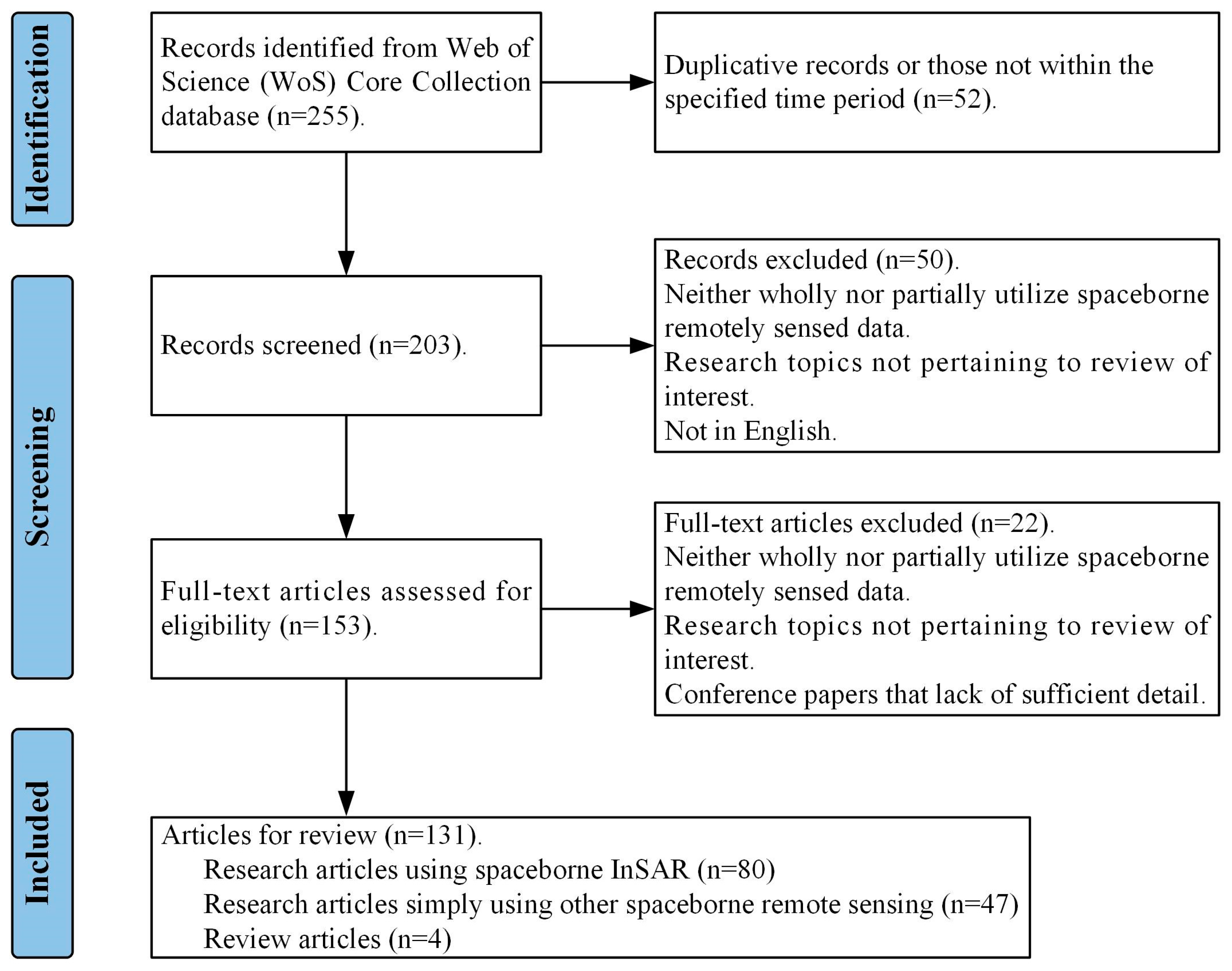
2. Article Inclusion Criteria and Description

The Preferred Reporting Items for Systematic Reviews and Meta-Analyses (PRISMA) workflow was utilized in this paper to conduct a systematic literature review on landslide monitoring and susceptibility mapping [39]. We used the advanced search query builder to gather literature from the WoS core collection database (Formula (1), where TI indicates title).
( T I = ( L a n d s l i d e ) )   A N D   ( T I = ( R e m o t e   S e n s i n g )   O R   T I = ( S a t e l l i t e )   O R   T I = ( I n S A R )   O R   T I = ( E a r t h   O b s e r v a t i o n ) )   A N D   ( T I = ( M o n i t o r )   O R   T I = ( M o n i t o r i n g )   O R   T I = ( P r e d i c t i o n )   O R   T I = ( S u s c e p t i b i l i t y ) )
The application of InSAR in landslide research typically encompasses a wide range of topics, such as landslide detection and inventory, monitoring, susceptibility mapping, risk and hazard assessment, early warning systems, and SAR hardware advancements specifically designed for landslide studies. However, this review primarily focuses on landslide monitoring and susceptibility mapping, which significantly narrows the scope presented in Figure 1. In addition, InSAR technology can be deployed across various platforms, including ground-based InSAR (GB-InSAR), unmanned aerial vehicles (UAVs)-based InSAR, and satellite-based InSAR. This review specifically examines the application of satellite-based InSAR, further refining the selection. Nevertheless, we have also included articles utilizing other spaceborne remote sensing technologies, such as optical remote sensing, within our querying results. This selection is justified for two reasons: Firstly, examining studies utilizing spaceborne remotely sensed data allows us to assess the proportion and trends of InSAR applications within the broader context. This approach not only confirms the current standing of InSAR but also reveals its future potential and directions for development. Secondly, landslide research is an interdisciplinary field where different spaceborne remote sensing technologies often complement each other. Especially for LSM, optical remote sensing provides high-resolution surface imagery to calculate diverse factors, while InSAR excels in measuring landslide deformation.
As of 15 March 2024, the initial search resulted in 255 articles, which were then refined using specific criteria. Only articles published in English between 1 January 2013, and 31 December 2023, were considered. We excluded studies that solely relied on field measurements or ground-based techniques (such as GB-InSAR) but included those utilizing other spaceborne remote sensing imagery. Additionally, duplicate and inaccessible articles, as well as some conference papers lacking sufficient detail for proper evaluation, were also excluded. The final literature collection for statistical analysis comprises 131 articles, including 80 research articles utilizing InSAR, 47 research articles simply using other spaceborne remote sensing, and 4 review articles (Figure 2).
Regarding the publication trends of the selected articles, the past decade has seen a marked increase (Figure 3), reflecting growing interest and advancements in relevant fields. The total number of publications reached 34 in 2023. Notably, the proportion of studies employing InSAR has also risen, indicating its increasing prominence. By 2023, InSAR-based publications constituted a substantial portion of the research, highlighting its critical role in landslide studies. This exponential growth indicates an expanding body of knowledge and an escalating interest in utilizing InSAR for landslide research, emphasizing the critical need to compile and review the burgeoning literature in this area.

3. InSAR Utilizations in the Selected Literature Collection

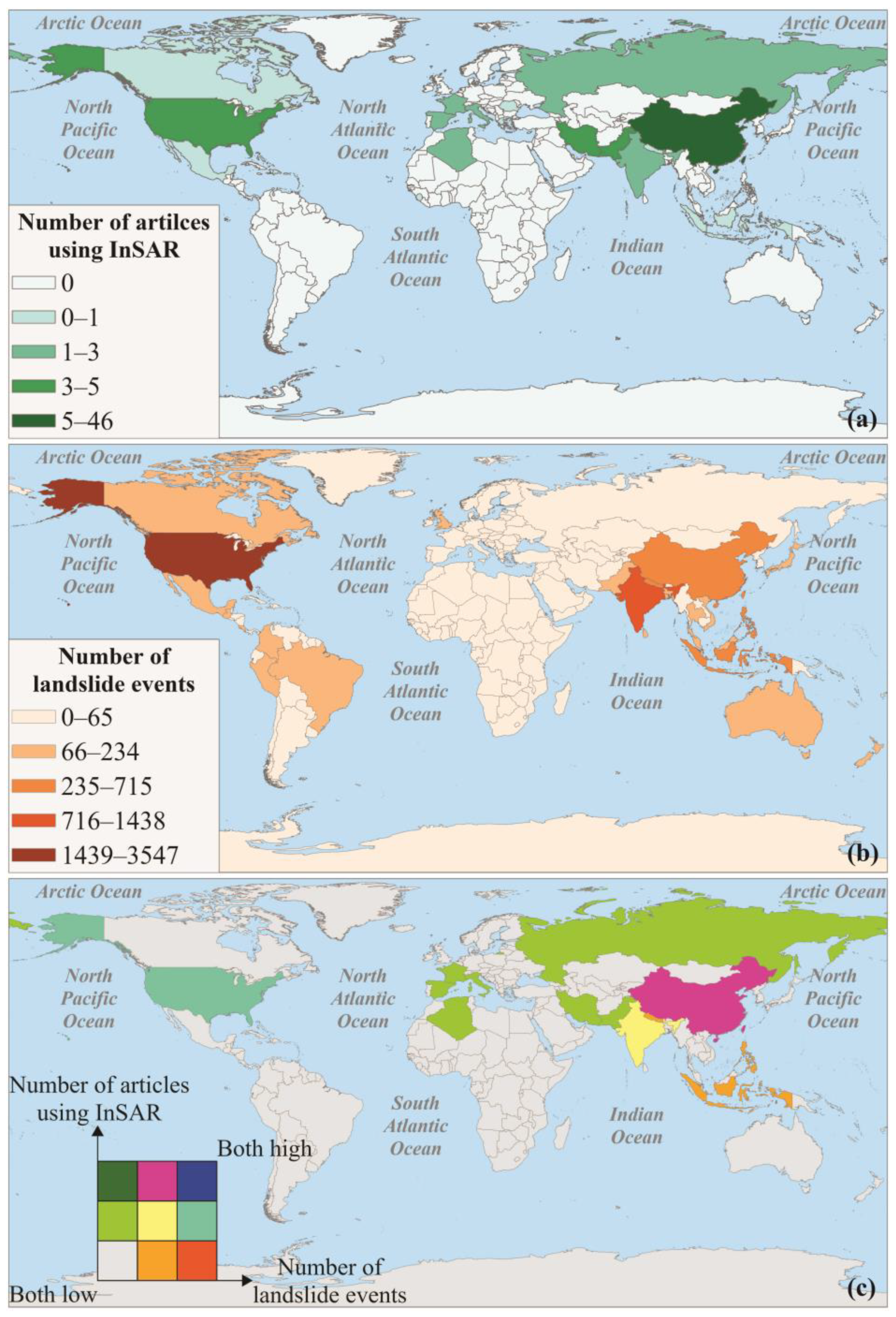
3.1. Global Distribution Patterns of Articles Utilizing InSAR

To understand how different countries adopt InSAR technology in response to their landslide hazards, we analyzed the geographical focus of the selected studies using InSAR and correlated them with the global occurrence of landslide events. Firstly, we examined the spatial distribution of landslide research utilizing InSAR by analyzing study areas, that is, the locations of the landslides being studied, from the included articles using InSAR (Figure 4a). The spatial pattern reveals that China, Pakistan, the United States, and Iran have made substantial contributions, with China alone accounting for 46 articles, over half of the total studies using InSAR (80 cases, as mentioned in Section 2). Countries such as Italy, France, Spain, and India have also shown notable interest in applying InSAR techniques to landslide research. A detailed list of articles utilizing InSAR and their corresponding study areas is provided in Appendix A, Table A1.
Moreover, we collected a comprehensive global landslide catalog dataset [40,41], which comprises rainfall-triggered landslide events worldwide with detailed location information. Leveraging the spatial join technique, the occurrence of landslide events across various countries was quantified (Figure 4b). Based solely on this dataset, the United States contributed to a dominant portion of global landslide events, followed by nations including India, China, Indonesia, Brazil, Australia, etc.
To enhance the visualization of the spatial distribution patterns of landslide research in relation to global landslide events, the natural breaks classification method (Jenks’ optimization) [42] was employed to categorize the number of published landslide articles and landslide events into three levels ranging from low to high, after which a bivariate choropleth map was created (Figure 4c), with the four corners of the legend representing the following different scenarios:
Bottom-left corner (both low): countries where both the number of recorded landslides and the number of InSAR-related landslide studies are low.
Top-right corner (both high): countries with a high number of recorded landslides and extensive InSAR-based landslide studies.
Top-left corner (low landslide frequency, high research activity): countries with relatively few recorded landslides but a high number of landslide studies using InSAR.
Bottom-right corner (high landslide frequency, low research activity): Countries with a high number of recorded landslides but limited InSAR-based landslide studies. These areas are particularly noteworthy for landslide monitoring and risk assessment.
In most cases, countries with frequent landslide occurrences, such as China and the United States, tend to receive more attention and are selected as study areas. Conversely, regions with relatively fewer landslide events, like most European and African countries, exhibit lower frequencies in the published landslide articles. However, it is noteworthy that despite India reporting a relatively high number of landslide events in this catalog, there remains considerable room for improvement in their use of InSAR technology to conduct landslide research. Similarly, countries like Canada, Mexico, Brazil, and Australia have reported several landslide events, yet the use of InSAR in these regions remains relatively scarce. This comparison reveals significant insights into regional research priorities and gaps, highlighting the need for more geographically balanced research efforts.

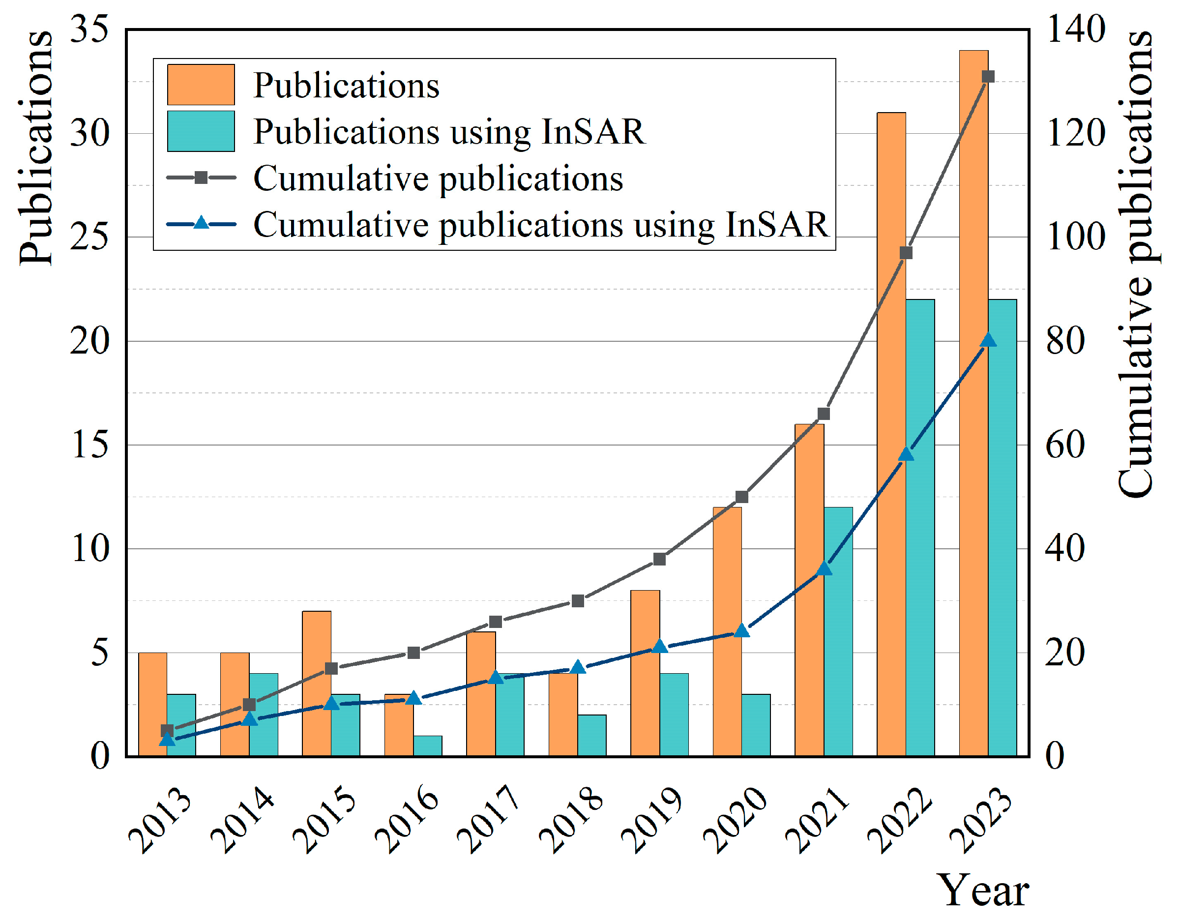
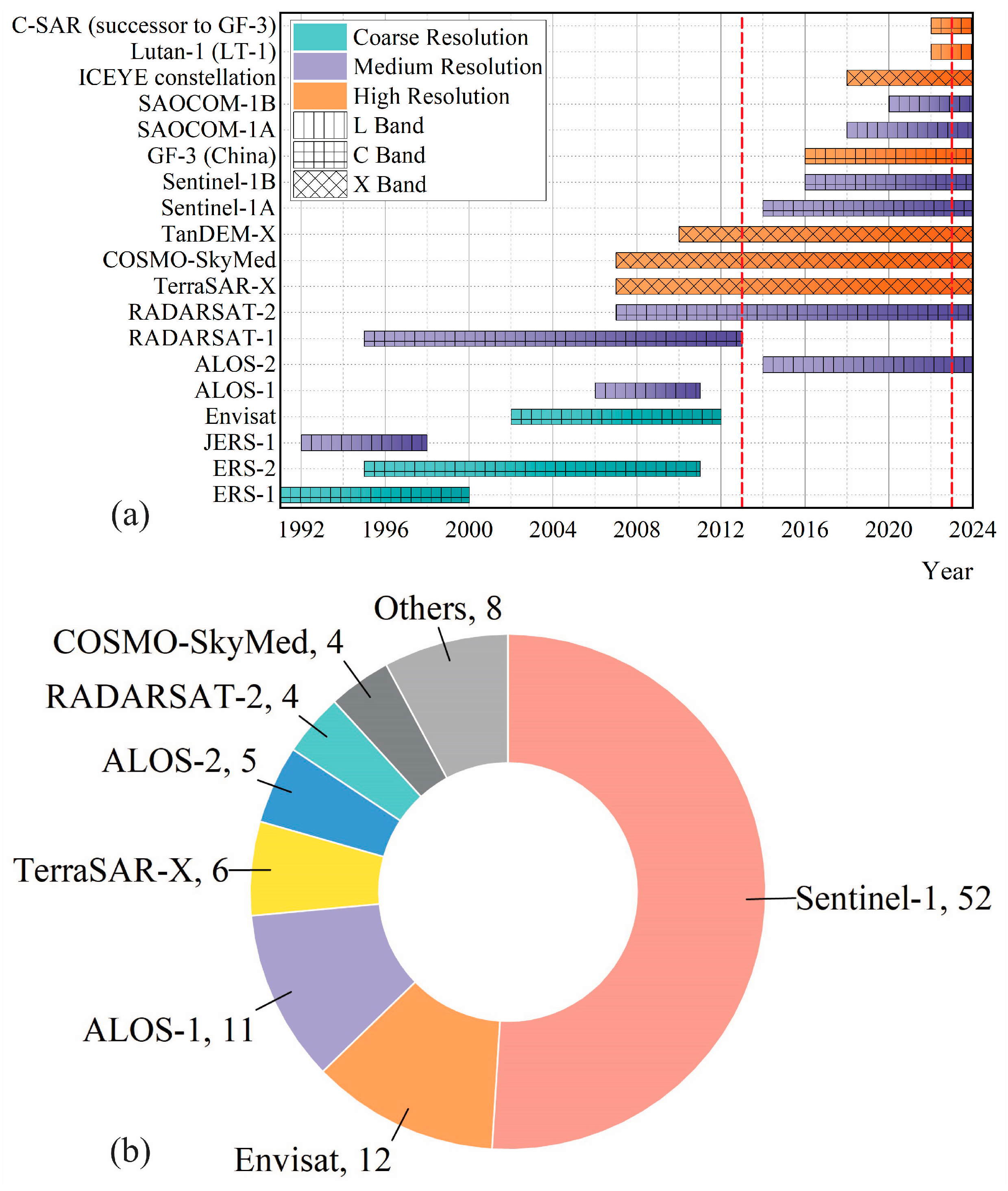
3.2. Development and Utilization of Spaceborne InSAR

Over the past few decades, there has been a significant increase in the deployment and operation of SAR satellite platforms, reflecting substantial growth in both their numbers and capabilities (Figure 5a). SAR systems can be categorized by the increase of wavelength into the X, C, and L bands, with longer wavelengths providing enhanced penetration capabilities into vegetation and soil. Moreover, the spatial resolution of SAR imagery has seen marked improvements over the years, evolving from the coarse resolution of ERS-1/2, suitable for large-scale deformation measurement but limited in detail, to the high resolution exemplified by TerraSAR-X and COSMO-SkyMed.
Out of the 80 selected research articles utilizing InSAR, Sentinel-1A/1B stands out as the most frequently used SAR data source, accounting for 52 studies (Figure 5b). This prominence is primarily attributed to its free and open data policy, high temporal resolution, and comprehensive and consistent global coverage, which make it highly accessible and practical for researchers worldwide. The launch of Sentinel-1B in 2016 and its pairing with Sentinel-1A reduced the revisit time from 12 days to 6 days, thereby facilitating more frequent monitoring of dynamic landslide processes. Envisat and ALOS-1/2 also feature prominently, reflecting their historical significance in studies requiring long-time series analysis or comparisons with historical data. Platforms such as TerraSAR-X, COSMO-SkyMed, and RADARSAT-2, although offering high-resolution imagery, are less commonly used due to data access restrictions and the costs associated with commercial data.
To gain a more detailed understanding of the application of InSAR in landslide monitoring and susceptibility mapping, we classified the selected articles based on their research topics and whether InSAR was utilized (Figure 6). Landslide monitoring has consistently integrated InSAR throughout the entire period as it typically requires the measurement of surface deformation. For LSM, however, although InSAR was acknowledged and utilized in a limited number of studies prior to 2020, its prevalence has significantly increased in recent years, particularly between 2021 and 2023. This surge indicates the growing exploration of InSAR’s capabilities in enhancing the accuracy and reliability of landslide susceptibility assessments, emphasizing the importance of a review to provide a comprehensive understanding of current advancements of InSAR in this field.

4. Applications of InSAR in Landslide Monitoring

4.1. Overview of InSAR Methodologies

The InSAR technique is widely utilized in landslide monitoring due to its capability of penetrating through clouds, enabling all-weather observation, and achieving millimeter-level deformation monitoring of landslides. Initially, the D-InSAR technique, which measures phase differences in single pair images, was widely used for landslide monitoring, as exemplified by Bondur et al. [43], who employed D-InSAR to assess the stability of a landslide zone on the Bureya River and revealed small-scale surface dynamics within the affected area. However, D-InSAR is constrained by spatial and temporal decorrelation and atmospheric delay errors, and demonstrates limitations in long-term monitoring. To compensate for these limitations, multi-temporal InSAR (MT-InSAR), which acquires multiple SAR images over a time series for analysis based on high-correlation points known as measurement points (MPs), has been widely used. According to the feature of MPs, MT-InSAR methods can be broadly categorized as persistent scatterer InSAR (PS-InSAR) methods, distributed scatterer InSAR (DS-InSAR) methods, and the methods combined persistent scatterers (PSs) and distributed scatterers (DSs).
PSs typically refer to targets with stable backscattering characteristics over long time series and are almost unaffected by spatial and temporal decorrelation, such as rocks, buildings, bridges, or artificial corner reflectors (CRs). Many PS-InSAR methods, such as StaMPS [44], PSI [45], and IPTA [46], have been used for landslide monitoring. However, landslides often occur in mountainous and densely vegetated areas with low coherence, where there may not be enough PSs for modeling and monitoring.
One solution is to optimize the phase of statistically homogeneous pixels (SHPs) within a particular spatial area and use high-quality optimized pixels as DSs to increase the density of measurement points (MPs). Various DS-InSAR methods, such as SBAS-InSAR [47], MSBAS-InSAR [48], and ISBAS-InSAR [49], have been proven to be applicable and efficient in landslide monitoring. In addition, Zhang et al. [50] proposed the adaptive distributed scatterer InSAR combined with land cover (ADSI-CLC) method for landslide monitoring in complex terrains, which incorporates land cover maps as a constraint for DS selection and employs a coherence weighted spatial adaptive filtering method to estimate the optimal phase, thereby enhancing DSs density and the efficiency of SHPs identification.
Additionally, some studies have attempted to utilize PSs and DSs simultaneously. For example, Zhu et al. [51] presented an improved adaptive network construction algorithm integrating both PSs and DSs to enhance the density of effective MPs and refine the accuracy of phase unwrapping, resulting in 7.8 times more points compared to the IPTA point network.
Based on the analysis of 61 landslide monitoring research articles in the selected literature collection (Figure 7), it is evident that the application of D-InSAR has been relatively uncommon over the past decade. Before 2018, PS-InSAR methods were slightly more prevalent than DS-InSAR methods. However, after 2018, methods based on DSs represent an overwhelming proportion. Although various MT-InSAR methods combining PSs and DSs have emerged in recent years, relevant research remains relatively scarce.

4.2. Recent Advances in Landslide Monitoring with InSAR

4.2.1. Enhancements in Atmospheric Delay Correction

Atmospheric delays, particularly those caused by the troposphere, significantly affect the accuracy of InSAR measurements. These delays occur because the radar signal travels through the atmosphere, which is influenced by factors such as temperature, pressure, and water vapor. The troposphere, being the lowest layer of the atmosphere, is especially impactful due to its highly variable conditions, manifesting as phase delays in the radar signal and leading to misinterpretation of deformation monitoring. The tropospheric delay can be divided into two main components: stratified delay and turbulent delay. To enhance the reliability of InSAR measurements, various methods have been developed to correct these delays.
A commonly used correction approach involves supplementary datasets, such as GNSS data [52,53], spectrometer observations [54,55], and numerical weather models (NWM) [56,57,58,59]. Although methods based on external data have demonstrated strong performance in numerous studies, they are typically constrained by the distribution density of stations and inconsistency with the spatial and temporal resolutions of SAR images.
Another approach involves the use of phase–elevation models, which exploit the relationships between phase delays and elevation to estimate the stratified tropospheric delay [60,61]. The conventional linear phase–elevation model posits a linear relationship between the unwrapped phase and the elevation, implying a uniform increase in delay with altitude [62]. While this model is easy to implement and its results are straightforward to interpret, it presumes atmospheric homogeneity and fails to account for the complexities of atmospheric variability. One recent solution is the power-law phase–elevation model [63], which introduces greater flexibility by allowing the phase delay to vary across multiple moving windows based on a power function of elevation. Another recent advancement is optimizing the traditional linear model by incorporating spatial variability in atmospheric conditions. For instance, ref. [64] developed a multi-temporal moving-window linear model (MMLM) that effectively addresses tropospheric delay in wide-area landslide investigations by modeling phases within a dynamic sliding window.
In addition, atmospheric delay correction benefits from the increasing application of deep learning models, which can learn complex atmospheric patterns from large datasets, offering efficient and accurate corrections. For example, Zhou et al. [65] introduced a deep learning approach, AtmNet, which leverages NWM without external data to correct spatial heterogeneity in tropospheric delays, particularly in mountainous regions. This method showed superior performance compared to traditional linear models and generic atmospheric correction models (GACOS).
Notably, although a considerable number of methods for InSAR atmospheric correction have been accumulated, it is necessary to judiciously select the appropriate atmospheric delay correction techniques tailored to specific geographical environments in order to enhance the accuracy of InSAR deformation monitoring [66].

4.2.2. Expanding Dimensions: 3D Monitoring with InSAR

InSAR measurements are typically taken along the line of sight (LOS) direction (Figure 8a). LOS observations only capture the component of movement along the radar’s line of sight, depicting the vector sum of vertical, north–south, and east–west, which may not fully capture the deformation characteristics of landslides. For example, horizontal movements parallel to the radar path or vertical displacements perpendicular to the LOS cannot be fully captured, leading to potential misinterpretation of the actual deformation. Moreover, the complexity of landslide dynamics, including rotational and translational movements, cannot be comprehensively resolved through single LOS observations alone.
To overcome the limitations of single LOS measurement, advancements in 3D landslide deformation monitoring have been made (Figure 8b). In fact, three significantly different geometric observations are required for the measurement of landslide three-dimensional (3D) deformation, which can then be used to calculate the 3D deformation information using Formula (2).
L O S 1 L O S 2 L O S 3 = cos α 1 sin θ 1 sin α 1 sin θ 1 cos θ 1 cos α 2 sin θ 2 sin α 2 sin θ 2 cos θ 2 cos α 3 sin θ 3 sin α 3 sin θ 3 cos θ 3 D e D n D v
where De, Dn, Dv indicate the deformation along the east, north, and vertical directions, respectively. L O S 1 , L O S 2 , and L O S 3 are the LOS deformation measured by SAR satellites. α 1 , α 2 , and α 3 are the heading angle of SAR satellites. θ 1 , θ 2 , and θ 3 are the incidence angle of SAR images.
However, the current spaceborne SAR platforms mainly operate in near-polar orbits, with typically two types of observations, i.e., ascending and descending orbits, resulting in only two significantly different geometric observations, especially for non-polar regions. Consequently, methods for landslide 3D deformation monitoring using spaceborne InSAR can be broadly categorized into two types.
The first type involves incorporating other techniques, such as pixel offset tracking (POT), to aid in 3D measurements, as demonstrated by Xu et al. [67], who reconstructed the 3D displacement field of the Hooskanaden landslide based on POT. Nevertheless, this type of method is more suitable for large-scale monitoring, as the deformation measurement accuracy derived from POT is relatively low.
Second, it is also possible to reduce the reliance on diverse geometric observations under specific assumptions, or based on prior information, such as reasonably ignoring north–south deformation according to the landslide location or assuming a translational sliding pattern to neglect vertical deformation. Based on the selected articles, the majority of studies have adopted this approach to achieve 3D deformation monitoring of landslides. For instance, Liu et al. [68] conducted an analysis of the vertical and east–west deformation in the Woda landslide area using Sentinel-1A ascending and descending datasets, which is insensitive to north–south displacement due to the flight direction characteristics of Sentinel-1A. Chen et al. [69] measured the east–west and vertical deformation rates of the Zongling landslides using both ALOS/PALSAR-2 ascending datasets and Sentinel-1A ascending and descending datasets. Ao et al. [70] employed a surface-parallel flow model to measure the 3D deformation of the Jiaju landslide.
It is worth noting that although multi-orbit InSAR has become the mainstream approach for landslide 3D deformation monitoring, for slope-scale research in steep, rugged terrains, where geometric distortions, especially shadows, may affect the availability of the InSAR data source, only ascending or descending single-orbit data may be suitable for analysis. Based on the selected literature, there are relatively few studies among selected articles addressing this issue. To the best of the authors’ knowledge, the utilization of single-orbit InSAR for 3D deformation monitoring in specific scenarios still requires exploration.

4.2.3. Integration of InSAR for Landslide Failure Time Prediction

Landslide prediction is vital for both researchers and practitioners in the fields of risk management, early warning, and prevention. Landslide prediction typically encompasses several aspects, such as displacement [71,72], failure time [73,74], potential affected areas [75,76], and susceptibility mapping [77,78]. Among these, landslide susceptibility mapping, which focuses on spatial prediction and delineating regions prone to landslides, will be discussed in Section 5. This section mainly focuses on failure time prediction, which typically relies on time-series monitoring of landslides. Predicting failure time is especially critical for guiding the determinations of the appropriate timing for interventions and prioritizing response efforts.
Based on creep theory, landslides are typically categorized into three stages: initial deformation, uniform deformation, and accelerated deformation [79]. Failure time prediction primarily focuses on the analysis of the tertiary stage. The most widely used model for this purpose is perhaps the Fukuzono model, also known as the inverse velocity model (INV), which establishes a quantitative relationship between velocity and acceleration during the final stage before failure [80]. Over the years, this model has been refined and widely applied in failure time prediction [81,82,83,84,85]. A key requirement for such prediction is the acquisition of accurate velocity–time data. Previous studies have mainly relied on in situ sensors’ monitoring, which face challenges in installation in remote areas and economic burdens.
As introduced in Section 1, the advent of InSAR has significantly transformed landslide research. In failure time prediction, several scholars have explored using InSAR-derived displacement data to estimate failure time. Moretto et al. were among the first to apply InSAR monitoring to failure time prediction [86]. They selected 56 landslides worldwide and successfully forecasted the failure dates for 4 of them, achieving a precision of less than five days. Another early successful case was the study by Intrieri et al. on the Moxian landslide, where they successfully estimated the failure date based on Sentinel-1 data and the INV, closely matching the actual failure event [87]. Additionally, Lacroix et al. used InSAR to predict the failure time three weeks in advance [73]. While this result might be influenced by the relatively long acceleration period and favorable observation conditions in the study area, it strongly demonstrated the feasibility of using InSAR for failure time prediction. Shankar et al. applied the INV and its modified version to accurately predict temporal windows of slope failure in the Himalayan region, further illustrating the applicability and practicality of InSAR-based predictions in remote, mountainous regions [88]. While there are other similar successful cases [76,89], most of these studies prefer to rely on the INV and its modifications. In fact, many other failure time prediction methods, such as the slope gradient method and the velocity over acceleration method, have also been shown to be effective for failure time estimation [74,90,91,92]. However, there is limited insight into their application in failure time prediction using InSAR-derived displacement data. Furthermore, deterministic methods often fail to account for uncertainties, leading to potentially unreliable predictions. While probabilistic analysis methods are well-established and widely used in conventional landslide monitoring, their application in InSAR-based failure time prediction remains relatively unexplored. Recognizing this gap, Zeng et al. were the first to integrate InSAR measurements with the INV and sequential Bayesian updating for probabilistic analysis, quantifying uncertainties and providing a more robust and reliable failure time prediction [93]. Despite this progress, the potential of applying probabilistic analysis in such scenarios remains insufficiently explored.
Recently, data-driven models and mathematical approaches have shown promising accuracy in predicting landslide displacement based on InSAR measurements [71,72,94,95,96]. This extends possibilities to integrate displacement prediction with failure time forecasting. That is, failure time predicting models could be applied based on predicted displacement patterns, offering practitioners more time to plan and implement preventive measures. However, the feasibility of this approach has yet to be explored. This method would depend more on the accuracy of displacement predictions, particularly in the accelerated deformation stage.

4.2.4. Improvements in Spatial Visibility and Temporal Resolution

Landslides tend to occur more frequently in steep and rugged terrain, where the geometric distortions caused by the satellite viewing geometry and side-looking imaging mode, including foreshortening, layover, and shadow, are more pronounced. Due to the influence of shadow, areas visible in ascending orbit InSAR data may not be observable in descending orbit mode, and vice versa. The variability in spatial visibility may lead to incomplete data coverage for a tentative study area, hindering comprehensive monitoring and analysis of landslide dynamics.
To overcome this challenge, scholars have found that overlaying images from different viewing geometries can enhance spatial visibility in regions affected by geometric distortions. By evaluating geometric distortions through the relationship between the geometric parameters of InSAR images and topographic data, the effective monitoring area for landslides can be identified. This is achieved by jointly processing measurement information from ascending and descending InSAR images using a masking process, thereby enhancing spatial visibility and enabling the precise extraction of deformation information. For example, Sun et al. [97] mapped the geometric distortions of ascending ALOS images and descending ENVISAT images of the Zhouqu region in China with DEM, thereby determining the most suitable data assembly and significantly improving the coverage of InSAR measurements. Guo et al. [98] conducted the visibility analysis to identify areas where the geometric distortions occurred in ALOS and Sentinel images in a reservoir region, masked the affected regions, and merged the effective observation areas from both SAR satellites, achieving a roughly 30% increase in the effective observation area.
Furthermore, the visibility of differing wavelengths of SAR images varies depending on different land use and land cover (LULC) conditions. Zhang et al. [99] monitored the deformations in the Three Gorges area with X-band, C-band, and L-band datasets, revealing that L-band ALOS is more effective for deformation monitoring in vegetated areas due to its excellent penetration capability. Bru et al. [100] evaluated the suitability of X-band COSMO-SkyMed and TerraSAR by conducting a visibility analysis with a matrix considering different land cover classifications and a proposed topographical relief index. This approach comprehensively considers the impact of both LULC and geometric distortions on spatial visibility in landslide monitoring. Building on this rationale, the integrated use of the differential penetration capabilities of various wavelengths and the observation geometry of ascending and descending orbits may further enhance the spatial visibility within the specific area. However, there is currently limited research that simultaneously considers these two aspects, and the integration may significantly increase the complexity of data processing, such as data registration, interferometric combination, phase unwrapping, etc.
From the perspective of improving temporal resolution, Cai et al. [19] proposed an innovative algorithm by employing the Kalman filter to dynamically integrate multi-platform InSAR observations into a unified time series, effectively enhancing the temporal resolution from 12 days with a single orbit to as short as 1 day and frequently to 2–5 days with multi-platform integration. In fact, the route of integrating InSAR observations from different SAR platforms into the same time series to enhance the temporal resolution has been validated in research within other domains such as permafrost and mining area monitoring [101,102], but remains relatively unexplored in the context of landslide studies. The revisit periods of SAR satellites directly affect the continuity of landslide monitoring and its application in predicting landslide occurrences and providing early warnings, particularly in failure time predictions. As emphasized by Morretto et al., a higher sampling frequency of InSAR data can lead to improved prediction accuracy [86,89], which has also been reported by several other studies [103,104]. As discussed in Section 4.2.3, failure time prediction is mainly based on creep theory, and for landslides with unclear or short accelerated tertiary phases, higher sampling frequency is crucial for improving prediction accuracy. However, a fundamental limitation of satellite-based InSAR is its relatively low temporal resolution, especially when compared to in situ sensors or GB-InSAR systems, which can easily achieve sampling frequencies at the minute level [105]. Even the widely used Sentinel-1 satellite, for instance, has a revisit period of up to six days. While data fusion may help achieve the goal of improving temporal resolution, it may also introduce challenges such as coherence loss, phase unwrapping errors, and variations in radar geometry. A promising development is that future InSAR constellation missions with a higher temporal resolution, along with the launch of geosynchronous SAR satellites like Ludi Tance-4 (01), are also expected to mitigate these limitations.

4.2.5. Advancements in Integrated Approaches Combining InSAR and Other Techniques

The integration of InSAR and the global navigation satellite system (GNSS) has garnered significant attention in landslide monitoring over the past years. Several methods have been employed in the integration process. One approach involves the fusion of InSAR and GNSS data to improve the spatial and temporal resolution of deformation measurements [106]. GNSS provides high temporal resolution and precise 3D positional data at specific points, while InSAR offers high spatial resolution over broad areas. By combining these datasets, more comprehensive monitoring of landslide dynamics can be achieved. Also, GNSS data can be used to correct and calibrate InSAR-derived deformation measurements. This correction helps to mitigate residual atmospheric delay phase error, residual topographic phase error, and orbital errors in InSAR data, enhancing the accuracy of the displacement maps [107,108]. Another significant advancement in the integration of InSAR and GNSS is the capability to achieve 3D deformation monitoring. By integrating GNSS data, which provides precise 3D positional information, vertical and horizontal deformation components can be decomposed from the LOS observations, thus obtaining a full 3D deformation vector [109,110]. Finally, InSAR observations can be validated by the truth deformation provided by GNSS stations. This validation is crucial for confirming the reliability of InSAR data in various terrains and conditions [111,112,113].
In addition to the aforementioned combination with GNSS, spaceborne InSAR can also be integrated with other technologies, such as optical remote sensing [114,115], light detection and ranging (LiDAR) [116,117], and UAVs [118,119], in landslide studies. These approaches provide a more comprehensive and accurate understanding of landslide behavior.
Although InSAR technology is capable of providing extensive surface deformation information, it still faces challenges in understanding failure mechanisms and potential controls of landslides. Therefore, in some studies, InSAR results are combined with geotechnical analysis (physical models) to delineate the landslide behavior and explain the physical processes, thereby guiding mitigation strategies. Especially for urban slopes, utilizing physical models makes more practical sense due to their proximity to urban areas, indicating higher landslide risk and potential serious consequences. For instance, Necula et al. [120] employed a combination of MT-InSAR and numerical modeling to assess urban landslide dynamics in eastern Romania, identifying the active deformation sectors and the underlying mechanisms. Tomás et al. [121] applied the limit equilibrium method (LEM) to model a landslide under various soil saturation levels and embankment scenarios, revealing the connections between InSAR-monitored instability, rainfall, and embankment construction. A key point to note is that in the construction of physical models, soil properties such as shear strength are often challenging to measure directly in the field or laboratory. Due to the study areas’ location, the abovementioned studies are more accessible for fieldwork and have historical monitoring datasets, including borehole information. Nevertheless, the data availability for physical modeling is still a challenge in some situations. To address this, missing parameters can be estimated through back analysis [122]. Some scholars argue that InSAR data can also be utilized to calibrate geotechnical models by adjusting model parameters until the simulated outcomes correspond with the observed deformations [123]. This method ensures that the models accurately represent the actual conditions and behaviors of landslides. In addition, physical models may also make reasonable assumptions to reduce the need for soil and rock parameters, such as assuming homogeneous soil properties in depth and laterally. Some studies tend to conduct probabilistic analysis instead of using deterministic models [124] as it reduces the uncertainties in soil properties’ variations by considering a range of possible outcomes rather than fixed parameters.

5. InSAR’s Role in Landslide Susceptibility Mapping

5.1. Factors and Their Utilization Frequency

Data-driven models for LSM typically rely on historical landslide events (landslide inventory dataset) and evaluation factors, referring to the input data layers such as lithology and precipitation. According to [125,126], these factors mainly comprise preparatory factors or predisposing factors which render the movement susceptibility of a slope and were widely used in LSM, and triggering factors like earthquake events and precipitation that directly trigger the movement.
To ascertain whether variables derived from InSAR, such as deformation velocity, can serve as evaluation factors in constructing data-driven LSM models, we first categorized and analyzed all evaluation factors used in the selected articles. This enabled us to determine the frequency of InSAR-derived factors and to extract the exact studies that incorporated these factors. While previous LSM studies have typically proposed diverse classification methods for evaluation factors and the factors they encompass, there is no standard or protocol for classifying and utilizing these factors in LSM due to the data accessibility and inter-relationships within the evaluation factors. Despite the uncertainty arising from the articles’ inclusion criteria, this review summarized the extensive use of 84 evaluation factors from the selected articles and categorized all factors into seven classifications (Table 1, Figure 9).
Notably, some evaluation factors used in prior studies do not have predisposing or triggering attributes, such as the InSAR-derived deformation velocity that we will focus on in this review, and cannot be classified into the other six categories, thus being labeled as ‘others’.

5.2. Utilization of InSAR-Derived Deformation Velocity in LSM

The deformation velocity induced by InSAR remote sensing has seen a growing recognition (Figure 10) due to increased data availability, as discussed in Section 3.2. In fact, during the factor statistical analysis, we not only identified the use of InSAR-derived deformation velocity as an evaluation factor but also uncovered several other applications of InSAR in LSM. To provide a comprehensive overview of the role of InSAR in LSM, this review categorized its contribution into ‘InSAR for optimization’, ‘InSAR derived factors’, and ‘other uses of InSAR’.
On the whole, based on the selected literature collection, the application of InSAR in LSM originated in 2019 and has shown an overall increasing trend. In 2023, over half of the LSM studies (12 out of 19) utilized the InSAR technique, with instances of a study using two forms of InSAR applications simultaneously for comparative study or to enhance LSM reliability.
Since 2022, there has been a growing tendency in research to optimize the LSM results using InSAR-derived deformation rates by some coupling methods, which generally refer to a contingency matrix [127,128,129], a correction matrix [130], a landslide susceptibility rating [131], etc. These methods typically involve generating a landslide susceptibility map using conventional factors such as slope, aspect, lithology, rainfall, etc., and then coupling this map with an InSAR-derived deformation map. For instance, Zhang et al. [132] employed a contribution matrix to revise the landslide susceptibility map with a ground deformation map, resulting in greater rationality and precision than the map without revision. Zhu et al. [133] effectively corrected the misclassified areas covering 59.48 km2, utilizing a contingency matrix to optimize the landslide susceptibility map with the deformation map generated by SBAS-InSAR. The primary hypothesis underlying this method is that areas exhibiting notable deformation velocities are more susceptible to landslides and should be assigned more significant weight. Some scholars also explored the potential of coupling deformation maps with physically based models. Dai et al. [134] presented a novel approach integrating the deformation map derived from SBAS-InSAR and stability coefficients derived from the Scoops 3D model, revealing the fact that relying solely on the InSAR technique or physical models may lead to an underestimation of landslide susceptibility.
However, Miao et al. [135] supposed that selecting an optimal coupling method for a landslide susceptibility map and deformation map retains significant uncertainties. They compared the results of incorporating deformation velocity as an evaluation factor for joint training in SVM and RF models by using a weighted overlay to couple the landslide susceptibility map and deformation map. The results indicated that both SVM and RF models achieved high under-the-curve (AUC) values when jointly trained with deformation velocity instead of coupling the two maps.
Indeed, directly using InSAR-derived factors and coupling InSAR for optimization have their strengths and limitations. While employing the coupling method to optimize the landslide susceptibility map typically offers greater flexibility, allowing for more reasonable matrix weights or formula parameters based on the actual conditions of the study area, this determination process is highly reliant on empirical knowledge and may introduce greater uncertainty into the optimized landslide susceptibility map. On the other hand, when using InSAR-derived factors for joint model training, InSAR data may be assigned a lower weight than other typically more influential factors, such as slope and rainfall, resulting in an underestimation of the susceptibility level in some areas. The reported importance of the two methods will be further discussed in the following section.
Other scholars have also attempted to explore different methods of incorporating InSAR to characterize a slow-moving sloped surface. Kontoes et al. [136] demonstrated that updating the landslide inventory dataset using InSAR leads to a more accurate landslide susceptibility map reflecting current ground surface conditions. Kursah et al. [137] compared frequency ratio models built using both archive and SBAS-InSAR-derived landslide inventory datasets, revealing that models based on InSAR-derived landslide inventory datasets had higher AUC values and degree-of-fit indexes. Chen et al. [138] augmented the archived landslide inventory dataset using PS- and DS-InSAR methods and proposed a new method for LSM, which significantly improved accuracy compared to models trained with the original dataset. These studies indicate that archived inventory datasets typically only record landslides that have already occurred without capturing slow-moving sloped surfaces, thus making the trained models insensitive to slow-moving events. In contrast, InSAR has the advantage of characterizing slow-moving slopes, which are precursors and may eventually lead to catastrophic landslides. Additionally, archived datasets often face a lag in data availability and may suffer from spatial biases, making it challenging to reflect recent surface features. Therefore, augmenting inventory datasets with InSAR enables the generation of more reliable and accurate landslide susceptibility maps that better reflect current surface conditions.
It should be noted that most studies in the selected literature collection tend to utilize Sentinel-1, which carries a single C-band synthetic aperture radar instrument, as the InSAR data source. Despite its widespread application in measuring deformation information demonstrated in Section 3.2, it is less sensitive in certain types of areas, such as vegetation-covered regions, which are pretty common in mountainous areas and reservoirs. In contrast, L-band satellites have longer wavelengths and stronger penetration capabilities, resulting in higher coherence in forests or other vegetated areas [139]. Although L-band applications in LSM are currently limited, this limitation may be addressed with the future availability of more long-wavelength InSAR data sources, such as the ALOS-4 planned by JAXA.

5.3. Reported Importance of InSAR in Landslide Susceptibility Mapping

To further illustrate the significance of InSAR-derived deformation velocity in LSM, we compiled articles employing InSAR for optimization (Table 2, as indicated by the line ‘Papers using InSAR for optimization’ in Figure 10) and those utilizing deformation velocity as an evaluation factor (Table 3, as indicated by the line ‘Papers using InSAR-Derived factors’ in Figure 10).
For studies employing InSAR-derived deformation maps for optimization, among the 12 articles listed, all but 1 reported positive optimization outcomes, indicating this approach’s significant role in enhancing LSM accuracy. Although not all articles provided pre- and post-optimization accuracy (e.g., AUC value), as they may focus on changes in the number and percentage of each susceptibility class cell, their case studies or field surveys quantitatively or qualitatively confirmed the improvements. Notably, the degree of accuracy improvement of this optimization method may be influenced by regional characteristics and specific coupling methodologies, suggesting the need for broader analysis to identify potential objective patterns.
When deformation velocity is used as an evaluation factor, it is evident that it does not consistently rank as a significant factor across various studies and region types. This inconsistency in ranking highlights the variability in the perceived importance of deformation velocity across different research contexts. The diverse region types—riverbank, hybrid area, and mountainous area—covered by these studies indicate that the relevance of deformation velocity can vary significantly based on geographic and environmental conditions. This variability may affect its perceived importance in landslide monitoring and susceptibility modeling. Furthermore, it is crucial to note that the small sample size (nine articles with only five giving the importance ranking) limits the depth and generalizability of this analysis. The limited number of studies incorporating deformation velocity as an evaluation factor might lead to an under-representation of its potential importance.
It is worth mentioning that these studies are inherently based on static susceptibility mapping, which relies on factors that can be considered almost time-invariant or averaged over long periods, such as slope, aspect, lithology, etc. InSAR-derived deformation velocity, often used as an annual average, is similarly treated as a static factor. However, landslide processes are inherently dynamic, influenced by natural and anthropogenic forces, and are indicated by temporal variations in factors such as rainfall, land use changes, and vegetation indices. The accelerated deformation generally indicates the occurrence of landslides [147], thus altering the susceptibility level. Evaluating the contribution of InSAR-derived deformation velocity solely based on its static representation may thus underestimate its true importance. Yet, a lack of LSM research focuses on the dynamic processes.

6. Future Research Directions

6.1. Dynamic Landslide Susceptibility Mapping and Prediction

The integration of time-series analysis into susceptibility mapping is crucial for capturing the temporal evolution of landslide susceptibility, which is inherently dynamic and influenced by factors such as vegetation growth, land use changes, and climate patterns. With the ability to monitor deformation over time, InSAR plays a vital role in introducing the temporal dimension into LSM. Recent studies have revealed that the landslide deformation typically exhibits seasonal patterns attributed to concentrated heavy precipitation [148,149]. Therefore, future research could incorporate InSAR-derived deformation to explore susceptibility variations across different timescales, such as seasonal, monthly, or even weekly, thereby reflecting the dynamic changes in susceptibility and their correlation with weather patterns and environmental factors. In addition, it may also be viable to integrate other dynamic factors that contribute to susceptibility, such as rainfall, groundwater level fluctuations, soil moisture, and vegetation conditions. These variables can be derived from various sources, including remote sensing observations, hydrological models, and in situ measurements. A comprehensive susceptibility mapping framework that synthesizes both spatial and temporal dynamics will significantly improve landslide prediction capabilities, thereby strengthening early warning systems and risk mitigation strategies.
Nonetheless, dynamic LSM typically focuses on assessing spatiotemporal variations in susceptibility and general risk at the regional scale. However, for specific landslides, incorporating displacement patterns over time allows for a more precise and near real-time understanding of slope behavior, as well as enabling dynamic prediction. Although significant progress has been made in displacement prediction based on InSAR, with several studies successfully establishing quantitative relationships between factors’ variations (e.g., rainfall and water levels) and displacement [95,150], failure time prediction remains more challenging. Current InSAR-based failure time prediction methods primarily rely on creep theory, as discussed in Section 4.2.3. These kinds of methods require clear identification and monitoring of the accelerated phase of landslides, but slopes might be influenced by multiple triggering factors such as rainfall, reservoir water level fluctuations, and human activities like road construction and mining. Some of these factors may introduce periodic behavior to the natural deformation trend, while others may disrupt the natural deformation process and even alter the stages of a landslide’s development, resulting in the low accuracy of failure time predictions based on creep theory. While existing studies have explored the impact of deformation stage division on landslide prediction and early warning [151], how to integrate these triggering factors to comprehensively analyze the failure characteristics of specific landslides is also worth exploring in future failure time studies. The application of data-driven models for failure time prediction might be a promising direction. By incorporating these triggering factors and dynamically updating them, along with accurate time-series displacement data to analyze deformation stages, this evolving approach could significantly enhance the accuracy and timeliness of failure time predictions, providing more reliable early warning capabilities.

6.2. Improvement of the Computational Efficiency of InSAR

In the context of dynamic LSM and landslide prediction, the processing and analysis of InSAR data must meet higher demands for computational efficiency. The processing of InSAR data, particularly when integrating observations from multiple platforms, can be computationally intensive due to the large volumes of data, the need for precise phase unwrapping, and the challenges associated with maintaining coherence over time. Enhancing the computational efficiency of InSAR processing allows for timely and accurate landslide susceptibility assessments and facilitates near real-time monitoring and early warning systems. In scenarios where rapid response is critical, such as in landslide-prone areas, enhancing computational efficiency can significantly improve the effectiveness of InSAR-based monitoring.
One promising direction is the development of advanced algorithms that optimize the processing of large-scale InSAR datasets. For instance, parallel computing and distributed processing techniques can significantly reduce the time required for InSAR data analysis [152,153]. By leveraging high-performance computing (HPC) resources, scholars can process extensive datasets more quickly, enabling real-time monitoring and more frequent updates of susceptibility maps. In addition, an optimized allocation of computational resources may also serve to enhance the efficiency of InSAR processing. Developing adaptive algorithms that dynamically adjust their processing strategies based on the data characteristics may also improve efficiency. These algorithms could prioritize areas with significant deformation or a higher risk of landslides, reducing the computational load by focusing resources where they are most needed.
Another issue for future research is the development of more efficient data compression and storage solutions. Given the high volume of InSAR data, effective compression techniques that maintain data integrity while reducing storage requirements can enhance both processing efficiency and accessibility. Additionally, cloud-based platforms for InSAR data managing and processing can provide extensible solutions that accommodate the increasing data volumes associated with dynamic landslide studies [154].

6.3. Mitigating Decorrelation Effects in Vegetated Areas

Selecting high-quality interferometric pairs is a crucial aspect of landslide monitoring using InSAR. While phase optimization methods, such as maximum likelihood estimation [155,156] and eigenvalue decomposition [157,158], are widely used, their performance in vegetated areas, where landslides often occur, might be suboptimal. Studies have shown that vegetation significantly affects InSAR coherence, with a negative correlation between vegetation density and coherence [159,160]. In fact, several factors can influence coherence in vegetated areas, including vegetation type, posture, height, seasonal variations, and weather-induced humidity changes.
To address this challenge, preliminary explorations have been made by scholars. One promising approach is to establish a quantitative relationship between InSAR decorrelation and vegetation characteristics, which could assist in selecting suitable SAR data before interferometric processing, thus reducing processing time. For instance, Pan et al. demonstrated that the NDVI can be used to quantitatively estimate InSAR decorrelation in both co- and cross-polarization modes by constructing second-order linear models [161]. Similarly, Guo et al. categorized interferometric pairs into groups with high and low vegetation coverage based on monthly FVC, applying group-specific average coherence thresholds to filter out low-quality pairs [162]. While such a method has proven to be effective, future research should account for the influence of different vegetation types and regional variations, as the quantitative relationships may need to be adapted to specific local conditions. In addition, considering the differences in the sensitivities of different polarization modes, Wang et al. explored a sequential polarimetric phase optimization algorithm that incorporates multi-polarization information and demonstrated its effectiveness [163]. However, this method does not account for the differences in scattering centers of ground objects across various polarization modes, which may lead to biased phase optimization results in vegetated areas. Nevertheless, it provides a new solution for minimizing decorrelation effects in vegetated areas.
As discussed in Section 4.2.4, long-wavelength SAR platforms exhibit better penetration capabilities, and the use of multi-orbit SAR imagery for monitoring vegetated areas has also proven effective [99,100,164]. However, challenges such as the limited availability of long-wavelength datasets, suboptimal temporal resolution, and suboptimal outcomes in the spatiotemporal fusion of multi-source data still remain. Future developments in SAR platforms may help address these issues. For example, the launch of satellites operating in long wavelengths, such as the recently launched L-band ALOS-4 mission [165], could facilitate the exploration of time series InSAR based on long-wavelength data. Additionally, with an increasing number of SAR satellites and the reduction in revisit times, methods for minimizing decorrelation effects in vegetated areas are expected to see satisfactory improvements.

7. Conclusions

In this review, we primarily examined the current trends, research landscape, and future research directions in landslide monitoring and susceptibility mapping from the perspective of the utilization of spaceborne InSAR. By analyzing the selected literature collection, we identified the recent surge of landslide research using spaceborne InSAR and the regional imbalances in such studies. We emphasized the emergence of various SAR platforms, particularly the significant role and application of Sentinel-1 in landslide research. These findings will provide reliable references for selecting research areas and SAR data sources in future InSAR applications for landslide studies.
In terms of landslide monitoring, we reviewed the principal InSAR methods and summarized recent advances in InSAR-based landslide monitoring across five aspects. Specifically, we observed the emergence of new approaches in atmospheric delay correction that account for spatial heterogeneity and temporal variation. In the monitoring dimension, we delineated the main strategies for achieving 3D monitoring with spaceborne InSAR and highlighted the importance of exploring single-orbit InSAR for 3D monitoring in areas where multi-orbit measurements are impeded by geometric distortion or limited data availability. We also summarize the role of InSAR-derived displacement data as a valuable tool in landslide failure time prediction, with recent advancements in probabilistic analysis and data-driven methods further enhancing its predictive capabilities. Regarding the spatiotemporal visibility of landslide monitoring, the research advance encompassed the integration of multi-platform, multi-frequency SAR imagery to enhance spatial visibility and the alignment of SAR images from different platforms into a unified time series to improve temporal resolution. Lastly, we reviewed the integration of spaceborne InSAR with other technologies in landslide monitoring, particularly the combination with physical models, which can offer valuable insights for validating and explaining landslide kinematics and failure patterns.
For LSM, we first cataloged all the evaluation factors and their frequencies in the selected literature collection, discovering that InSAR-derived factors, specifically deformation velocity, appeared infrequently (only nine cases). Among these nine cases, the importance of this factor varied significantly. We suggested that future research could delve into more comprehensive analyses by exploring a broader literature dataset. Additionally, we found that some studies employed coupling methods to use InSAR-derived deformation maps for optimizing susceptibility maps (12 cases), and most of these studies reported significant performance improvements quantitatively or qualitatively. We pointed out that the current LSM primarily focuses on static mapping, with InSAR-derived factors or maps often treated as static attributes (e.g., annual averages). However, InSAR should not be evaluated solely as a static factor; instead, its potential to capture temporal variations should be leveraged to enhance LSM.
Therefore, we suggested greater attention should be paid to dynamic LSM, which integrates time-series analyses and multiple dynamic factors—such as InSAR-derived displacement, rainfall, vegetation conditions, and soil moisture—to assess temporal variations in susceptibility. Incorporating these elements enables a more refined understanding of landslide risk evolution and strengthens early warning. Additionally, we highlight the potential of integrating data-driven approaches with failure time prediction models, particularly for slopes influenced by multiple triggering factors. Notably, this developmental trend highlights the need for effective management and processing of SAR big data, necessitating a focus on efficient computation strategies for InSAR and the optimization of data compression and storage solutions.

Author Contributions

Y.C.: Conceptualization, methodology, software, formal analysis, data curation, investigation, visualization, writing—original draft, and writing—review and editing. H.P.: Conceptualization, methodology, data curation, investigation, and writing—review and editing. Y.L.: Conceptualization, methodology, data curation, investigation, visualization, writing—review and editing, and supervision. L.F.: Conceptualization, data curation, investigation, and writing—review and editing. S.W.: Data curation, and investigation. Z.Y.: Data curation, and writing—review and editing. Y.F.: Investigation, and writing—review and editing. All authors have read and agreed to the published version of the manuscript.

Funding

This research received no external funding.

Acknowledgments

The authors would like to thank to Monash University, Australia, for the invaluable support provided throughout this research.

Conflicts of Interest

The authors declare no conflict of interest.

Appendix A

Table A1. Summary of articles using InSAR and their corresponding study areas.
ArticleStudy AreaArticleStudy Area
[51]Wumeng Mountain, Guizhou Province, China[166]Thompson River Valley, British Columbia, Canada
[65]Mao County, Sichuan Province, China[112]southeastern Taiwan, China
[167]northeastern Chongqing, China[45]a landslide in Carlantino, Italy
[123]Kahroud Village, Iran[97]Zhouqu County, Gansu Province, China
[121]Southeast of Alcoy, Spain[99]Three Gorges area, China
[168]Baihetan hydropower station, China[169]junction of Dujiangyan and Wenchuan City, Sichuan Province, China
[149]Woda landslide, Tibet, China[170]the Poche and La Valette landslides, France
[171]Qidashan open-pit mine and Yabaling open-pit mine, Liaoning Province, China[108]a landslide located at the north of Shannxi Province, China
[26]Cirque de Salazie (CdS), Réunion Island, France[172]Shuping landslide, Hubei Province, China
[173]Kaiyang landslides, Guizhou Province, China[44]two landslides at the foothills of the Greater Caucasus, Russia
[50]Jiaju Landslide, Sichuan Province, China[174]Fanjiaping landslide, Hubei Province, China
[175]Mao County, Sichuan Province, China[176]Wudongde hydropower station, Yunnan Province, China
[71]Cihaxia hydropower station, Qinghai Province, China[177]Damavand Volcano, Iran
[64]Lianghekou hydropower station, Sichuan Province, China[178]Badong County, Hubei Province, China
[179]Temi landslide, junction of Sichuan Province and Tibet, China[132]west of Hubei Province, China
[25]Mila, Algeria[140]Lishui, Zhejiang Province, China
[49]Lake Michigan shoreline, US[29]southeast of the Tibetan Plateau, China
[76]Kikruma landslide and Kotropi landslide, Himalaya region, India.[141]Weining County, Guizhou Province, China
[24]Valle d’Aosta, Italy[135]Wanzhou District, Chongqing, China
[148]south of Maskun landslide, Iran[47]Yunnan Province, China
[180]Mila Basin, Algeria[130]a section of Karakoram Highway, Pakistan
[113]Jinsha river between the Ahai and Liyuan hydropower station, China[28]a section of Karakoram Highway, Pakistan
[68]Woda landslide, Tibet, China[27]southwestern part of Lincang City, Yunnan Province, China
[181]Cheyiping landslide, Yunnan Province, China[134]Baihetan Dam, junction of Sichuan and Yunnan Province, China
[69]Zongling landslide, Guizhou Province, China[138]Hong Kong, China
[19]Baige Landslide, Sichuan Province, China[131]a road corridor from Polewali to Mambi, Indonesia
[182]Gold Basin landslide complex, Washington, US[133]Dongchuan district, Kunming, Yunnan Province, China
[46]Tijuana—Ensenada Scenic Highway, Baja California, Mexico[128]area along the north Lancang River, China
[115]Liupanshui, Guiyang, and Tongren, Guizhou Province, China[143]Suicheng County, Guangzhou Province, China
[183]Eldorado National Forest, in central California, US[144]Ludian County, Yunnan Province, China
[98]Gushui hydropower station, Yunnan Province, China[184]Ghizer valley, Pakistan
[48]Dominica[127]Chitral valley, Pakistan
[185]Danba County, Sichuan Province, China[145]Siaolin Village and the Putunpunas River area, Taiwan, China
[43]Bureya River, Russia[137]Sierra Leone
[186]Trishuli River catchment, Nepal[136]part of the Pindus Mountain, Greece
[111]Jinping, Niexia, and Xishancun landslides, Sichuan Province, China[142]a section of Karakoram Highway, Pakistan
[187]Slumgullion landslide, Colorada, US[146]Uttarakhand, India
[188]Wudongde hydropower station, junction of Sichuan and Yunan Province, China[189]Carpathian and Subcarpathian Prahova Valley, Romania
[100]Deba Valley, Spain[129]a section of Karakoram Highway, China
[190]Shabkola, Iran[191]Sorrentina Peninsula, Italy

References

  1. Hungr, O.; Leroueil, S.; Picarelli, L. The Varnes Classification of Landslide Types, an Update. Landslides 2014, 11, 167–194. [Google Scholar] [CrossRef]
  2. 2022 Global Natural Disaster Assessment Report. Available online: https://www.preventionweb.net/publication/2022-global-natural-disaster-assessment-report (accessed on 28 May 2024).
  3. United Nations Papua New Guinea. The United Nations Ongoing Assistance in Response to Landslide Disaster in Enga Province, Papua New Guinea—May 2024. Available online: https://papuanewguinea.un.org/en/269665-united-nations-ongoing-assistance-response-landslide-disaster-enga-province-papua-new-guinea (accessed on 28 May 2024).
  4. UNISDR, (United Nations International Strategy for Disaster Reduction). Sendai Framework for Disaster Risk Reduction 2015–2030; United Nations International Strategy for Disaster Reduction: Geneva, Switzerland, 2015. [Google Scholar]
  5. United Nations. Transforming Our World: The 2030 Agenda for Sustainable Development. Available online: https://sustainabledevelopment.un.org/post2015/transformingourworld/publication (accessed on 28 May 2024).
  6. Gili, J.A.; Corominas, J.; Rius, J. Using Global Positioning System Techniques in Landslide Monitoring. Eng. Geol. 2000, 55, 167–192. [Google Scholar] [CrossRef]
  7. Squarzoni, C.; Delacourt, C.; Allemand, P. Differential Single-Frequency GPS Monitoring of the La Valette Landslide (French Alps). Eng. Geol. 2005, 79, 215–229. [Google Scholar] [CrossRef]
  8. Rawat, M.; Joshi, V.; Rawat, B.; Kumar, K. Landslide Movement Monitoring Using GPS Technology: A Case Study of Bakthang Landslide, Gangtok, East Sikkim, India. J. Dev. Agric. Econ. 2011, 3, 194–200. [Google Scholar]
  9. Moore, J.R.; Gischig, V.; Button, E.; Loew, S. Rockslide Deformation Monitoring with Fiber Optic Strain Sensors. Nat. Hazards Earth Syst. Sci. 2010, 10, 191–201. [Google Scholar] [CrossRef]
  10. Dixon, N.; Spriggs, M.P.; Smith, A.; Meldrum, P.; Haslam, E. Quantification of Reactivated Landslide Behaviour Using Acoustic Emission Monitoring. Landslides 2015, 12, 549–560. [Google Scholar] [CrossRef]
  11. Abraham, M.T.; Satyam, N.; Pradhan, B.; Alamri, A.M. IoT-Based Geotechnical Monitoring of Unstable Slopes for Landslide Early Warning in the Darjeeling Himalayas. Sensors 2020, 20, 2611. [Google Scholar] [CrossRef]
  12. Cheng, G.; Guo, L.; Zhao, T.; Han, J.; Li, H.; Fang, J. Automatic Landslide Detection from Remote-Sensing Imagery Using a Scene Classification Method Based on BoVW and pLSA. Int. J. Remote Sens. 2013, 34, 45–59. [Google Scholar] [CrossRef]
  13. Golovko, D.; Roessner, S.; Behling, R.; Wetzel, H.-U.; Kleinschmit, B. Evaluation of Remote-Sensing-Based Landslide Inventories for Hazard Assessment in Southern Kyrgyzstan. Remote Sens. 2017, 9, 943. [Google Scholar] [CrossRef]
  14. Niu, C.; Ma, K.; Shen, X.; Wang, X.; Xie, X.; Tan, L.; Xue, Y. Attention-Enhanced Region Proposal Networks for Multi-Scale Landslide and Mudslide Detection from Optical Remote Sensing Images. Land 2023, 12, 313. [Google Scholar] [CrossRef]
  15. Stumpf, A.; Malet, J.; Delacourt, C. Correlation of Satellite Image Time-Series for the Detection and Monitoring of Slow-Moving Landslides. Remote Sens. Environ. 2017, 189, 40–55. [Google Scholar] [CrossRef]
  16. Wang, S.; Yang, B.; Zhou, Y.; Wang, F.; Zhang, R.; Zhao, Q. Three-Dimensional Information Extraction from GaoFen-1 Satellite Images for Landslide Monitoring. Geomorphology 2018, 309, 77–85. [Google Scholar] [CrossRef]
  17. Zebker, H.A.; Goldstein, R.M. Topographic Mapping from Interferometric Synthetic Aperture Radar Observations. In NASA (JPL Aircraft SAR Workshop Proc.); NASA: Washington, DC, USA, 1985. [Google Scholar]
  18. Achache, J.; Fruneau, B.; Delacourt, C. Applicability of SAR Interferometry for Monitoring of Landslides. In Proceedings of the Second ERS Applications Workshop, London, UK, 6–8 December 1996; Volume 383, p. 165. [Google Scholar]
  19. Cai, J.; Liu, G.; Jia, H.; Zhang, B.; Wu, R.; Fu, Y.; Xiang, W.; Mao, W.; Wang, X.; Zhang, R. A New Algorithm for Landslide Dynamic Monitoring with High Temporal Resolution by Kalman Filter Integration of Multiplatform Time-Series InSAR Processing. Int. J. Appl. Earth Obs. Geoinf. 2022, 110, 102812. [Google Scholar] [CrossRef]
  20. Liu, Z.; Qiu, H.; Zhu, Y.; Liu, Y.; Yang, D.; Ma, S.; Zhang, J.; Wang, Y.; Wang, L.; Tang, B. Efficient Identification and Monitoring of Landslides by Time-Series InSAR Combining Single- and Multi-Look Phases. Remote Sens. 2022, 14, 1026. [Google Scholar] [CrossRef]
  21. Zhu, W.; Yang, L.; Cheng, Y.; Liu, X.; Zhang, R. Active Thickness Estimation and Failure Simulation of Translational Landslide Using Multi-Orbit InSAR Observations: A Case Study of the Xiongba Landslide. Int. J. Appl. Earth Obs. Geoinf. 2024, 129, 103801. [Google Scholar] [CrossRef]
  22. Li, M.; Zhang, L.; Yang, M.; Liao, M. Complex Surface Displacements of the Nanyu Landslide in Zhouqu, China Revealed by Multi-Platform InSAR Observations. Eng. Geol. 2023, 317, 107069. [Google Scholar] [CrossRef]
  23. Liu, Y.; Yao, X.; Gu, Z.; Zhou, Z.; Liu, X.; Wei, S. Study on InSAR Image Fusion for Improved Visualization of Active Landslides in Alpine Valley Areas: A Case in the Batang Region, China. Comput. Geosci. 2024, 186, 105481. [Google Scholar] [CrossRef]
  24. Reale, D.; Verde, S.; Calo, F.; Imperatore, P.; Pauciullo, A.; Pepe, A.; Zamparelli, V.; Sansosti, E.; Fornaro, G. Multipass InSAR with Multiple Bands: Application to Landslides Mapping and Monitoring. In Proceedings of the IGARSS 2022—2022 IEEE International Geoscience and Remote Sensing Symposium, Kuala Lumpur, Malaysia, 17 July 2022; pp. 4510–4513. [Google Scholar]
  25. Smail, T.; Abed, M.; Mebarki, A.; Lazecky, M. Earthquake-Induced Landslide Monitoring and Survey by Means of InSAR. Nat. Hazards Earth Syst. Sci. 2022, 22, 1609–1625. [Google Scholar] [CrossRef]
  26. De Michele, M.; Raucoules, D.; Rault, C.; Aunay, B.; Foumelis, M. Short Communication: Potential of Sentinel-1 Interferometric Synthetic Aperture Radar (InSAR) and Offset Tracking in Monitoring Post-Cyclonic Landslide Activities on Réunion. Earth Surf. Dynam. 2023, 11, 451–460. [Google Scholar] [CrossRef]
  27. Deng, Y.; Zuo, X.; Li, Y.; Zhou, X. Landslide Susceptibility Evaluation of Bayesian Optimized CNN Gengma Seismic Zone Considering InSAR Deformation. Appl. Sci. 2023, 13, 11388. [Google Scholar] [CrossRef]
  28. Hussain, M.A.; Chen, Z.; Zheng, Y.; Zhou, Y.; Daud, H. Deep Learning and Machine Learning Models for Landslide Susceptibility Mapping with Remote Sensing Data. Remote Sens. 2023, 15, 4703. [Google Scholar] [CrossRef]
  29. Yao, J.; Yao, X.; Zhao, Z.; Liu, X. Performance Comparison of Landslide Susceptibility Mapping under Multiple Machine-Learning Based Models Considering InSAR Deformation: A Case Study of the Upper Jinsha River. Geomat. Nat. Hazards Risk 2023, 14, 2212833. [Google Scholar] [CrossRef]
  30. Guzzetti, F.; Reichenbach, P.; Cardinali, M.; Galli, M.; Ardizzone, F. Probabilistic Landslide Hazard Assessment at the Basin Scale. Geomorphology 2005, 72, 272–299. [Google Scholar] [CrossRef]
  31. Bhattacharya, A.; Mukherjee, K. Review on InSAR Based Displacement Monitoring of Indian Himalayas: Issues, Challenges and Possible Advanced Alternatives. Geocarto Int. 2017, 32, 298–321. [Google Scholar] [CrossRef]
  32. Soldato, M.D.; Confuorto, P.; Bianchini, S.; Sbarra, P.; Casagli, N. Review of Works Combining GNSS and InSAR in Europe. Remote Sens. 2021, 13, 1684. [Google Scholar] [CrossRef]
  33. Li, S.; Xu, W.; Li, Z. Review of the SBAS InSAR Time-Series Algorithms, Applications, and Challenges. Geod. Geodyn. 2022, 13, 114–126. [Google Scholar] [CrossRef]
  34. Coutinho, R.; Alves, J.; Moreira, H.; Pontes, J.; Aragão Júnior, W. Applicability of the InSAR Technique for Slope Monitoring. S&R 2023, 46, e2023008023. [Google Scholar] [CrossRef]
  35. Liu, S.; Wang, L.; Zhang, W.; He, Y.; Pijush, S. A Comprehensive Review of Machine Learning-based Methods in Landslide Susceptibility Mapping. Geol. J. 2023, 58, 2283–2301. [Google Scholar] [CrossRef]
  36. Pacheco Quevedo, R.; Velastegui-Montoya, A.; Montalván-Burbano, N.; Morante-Carballo, F.; Korup, O.; Daleles Rennó, C. Land Use and Land Cover as a Conditioning Factor in Landslide Susceptibility: A Literature Review. Landslides 2023, 20, 967–982. [Google Scholar] [CrossRef]
  37. Bisht, S.; Rawat, K.S. A Review of Statistical Approaches Used for Landslide Susceptibility Analysis with the Help of Remote Sensing and GIS Technology. Acta Sci. Pol. Form. Circumiectus 2023, 22, 83–96. [Google Scholar] [CrossRef]
  38. Bhardwaj, V.; Singh, K. Landslide Susceptibility Assessment Using Remote Sensing and GIS-a Review. J. Min. Environ. 2023, 70, 133–154. [Google Scholar] [CrossRef]
  39. Page, M.J.; Moher, D.; Bossuyt, P.M.; Boutron, I.; Hoffmann, T.C.; Mulrow, C.D.; Shamseer, L.; Tetzlaff, J.M.; Akl, E.A.; Brennan, S.E.; et al. PRISMA 2020 Explanation and Elaboration: Updated Guidance and Exemplars for Reporting Systematic Reviews. BMJ 2021, 372, n160. [Google Scholar] [CrossRef]
  40. Kirschbaum, D.B.; Adler, R.; Hong, Y.; Hill, S.; Lerner-Lam, A. A Global Landslide Catalog for Hazard Applications: Method, Results, and Limitations. Nat. Hazards 2010, 52, 561–575. [Google Scholar] [CrossRef]
  41. Kirschbaum, D.; Stanley, T.; Zhou, Y. Spatial and Temporal Analysis of a Global Landslide Catalog. Geomorphology 2015, 249, 4–15. [Google Scholar] [CrossRef]
  42. Jenks, G.F. The Data Model Concept in Statistical Mapping. In International Yearbook of Cartography; George Philip: River Vale, NJ, USA, 1967; Volume 7, pp. 186–190. [Google Scholar]
  43. Bondur, V.G.; Zakharova, L.N.; Zakharov, A.I. Monitoring the State of the Landslide Zone on the Bureya River in 2018–2019 with Radar and Optical Satellite Images. Izv. Atmos. Ocean. Phys. 2020, 56, 1520–1527. [Google Scholar] [CrossRef]
  44. Mikhailov, V.O.; Kiseleva, E.A.; Smol’yaninova, E.I.; Dmitriev, P.N.; Golubev, V.I.; Isaev, Y.S.; Dorokhin, K.A.; Timoshkina, E.P.; Khairetdinov, S.A. Some Problems of Landslide Monitoring Using Satellite Radar Imagery with Different Wavelengths: Case Study of Two Landslides in the Region of Greater Sochi. Izv. Phys. Solid Earth 2014, 50, 576–587. [Google Scholar] [CrossRef]
  45. Bovenga, F.; Pasquariello, G.; Pellicani, R.; Refice, A.; Spilotro, G. Landslide Monitoring for Risk Mitigation by Using Corner Reflector and Satellite SAR Interferometry: The Large Landslide of Carlantino (Italy). CATENA 2017, 151, 49–62. [Google Scholar] [CrossRef]
  46. Sarychikhina, O.; Palacios, D.G.; Delgado Argote, L.A.; Ortega, A.G. Application of Satellite SAR Interferometry for the Detection and Monitoring of Landslides along the Tijuana—Ensenada Scenic Highway, Baja California, Mexico. J. S. Am. Earth Sci. 2021, 107, 103030. [Google Scholar] [CrossRef]
  47. Liu, M.; Xu, B.; Li, Z.; Mao, W.; Zhu, Y.; Hou, J.; Liu, W. Landslide Susceptibility Zoning in Yunnan Province Based on SBAS-InSAR Technology and a Random Forest Model. Remote Sens. 2023, 15, 2864. [Google Scholar] [CrossRef]
  48. Fobert, M.; Singhroy, V.; Spray, J. InSAR Monitoring of Landslide Activity in Dominica. Remote Sens. 2021, 13, 815. [Google Scholar] [CrossRef]
  49. Sataer, G.; Sultan, M.; Emil, M.K.; Yellich, J.A.; Palaseanu-Lovejoy, M.; Becker, R.; Gebremichael, E.; Abdelmohsen, K. Remote Sensing Application for Landslide Detection, Monitoring along Eastern Lake Michigan (Miami Park, MI). Remote Sens. 2022, 14, 3474. [Google Scholar] [CrossRef]
  50. Zhang, Z.; Zeng, Q.; Jiao, J. Deformations Monitoring in Complicated-Surface Areas by Adaptive Distributed Scatterer InSAR Combined with Land Cover: Taking the Jiaju Landslide in Danba, China as an Example. ISPRS J. Photogramm. Remote Sens. 2022, 186, 102–122. [Google Scholar] [CrossRef]
  51. Zhu, Y.; Tian, B.; Xie, C.; Guo, Y.; Fang, H.; Yang, Y.; Wang, Q.; Zhang, M.; Shen, C.; Wei, R. Multi-Temporal InSAR Deformation Monitoring Zongling Landslide Group in Guizhou Province Based on the Adaptive Network Method. Sustainability 2023, 15, 894. [Google Scholar] [CrossRef]
  52. Reuveni, Y.; Bock, Y.; Tong, X.; Moore, A.W. Calibrating Interferometric Synthetic Aperture Radar (InSAR) Images with Regional GPS Network Atmosphere Models. Geophys. J. Int. 2015, 202, 2106–2119. [Google Scholar] [CrossRef]
  53. Yu, C.; Li, Z.; Penna, N.T. Interferometric Synthetic Aperture Radar Atmospheric Correction Using a GPS-Based Iterative Tropospheric Decomposition Model. Remote Sens. Environ. 2018, 204, 109–121. [Google Scholar] [CrossRef]
  54. Li, Z.; Muller, J.-P.; Cross, P.; Fielding, E.J. Interferometric Synthetic Aperture Radar (InSAR) Atmospheric Correction: GPS, Moderate Resolution Imaging Spectroradiometer (MODIS), and InSAR Integration. J. Geophys. Res. Solid Earth 2005, 110, B034110. [Google Scholar] [CrossRef]
  55. Li, Z.W.; Xu, W.B.; Feng, G.C.; Hu, J.; Wang, C.C.; Ding, X.L.; Zhu, J.J. Correcting Atmospheric Effects on InSAR with MERIS Water Vapour Data and Elevation-Dependent Interpolation Model. Geophys. J. Int. 2012, 189, 898–910. [Google Scholar] [CrossRef]
  56. Jung, J.; Kim, D.-j. Correction of Tropospheric Phase Delay in Time Series InSAR Using WRF Model for Monitoring Shinmoedake Volcano. In Proceedings of the 2013 IEEE International Geoscience and Remote Sensing Symposium—IGARSS, Melbourne, Australia, 21 July 2013; pp. 137–140. [Google Scholar]
  57. Kinoshita, Y.; Furuya, M.; Hobiger, T.; Ichikawa, R. Are Numerical Weather Model Outputs Helpful to Reduce Tropospheric Delay Signals in InSAR Data? J. Geod. 2013, 87, 267–277. [Google Scholar] [CrossRef]
  58. Wang, Q.; Yu, W.; Xu, B.; Wei, G. Assessing the Use of GACOS Products for SBAS-InSAR Deformation Monitoring: A Case in Southern California. Sensors 2019, 19, 3894. [Google Scholar] [CrossRef]
  59. Kirui, P.; Riedel, B.; Gerke, M. Performance of numerical weather products for InSAR tropospheric correction: A case study of a tropical region. ISPRS Ann. Photogramm. Remote Sens. Spatial Inf. Sci. 2022, V-3-2022, 115–122. [Google Scholar] [CrossRef]
  60. Liang, H.; Zhang, L.; Ding, X.; Lu, Z.; Li, X. Toward Mitigating Stratified Tropospheric Delays in Multitemporal InSAR: A Quadtree Aided Joint Model. IEEE Trans. Geosci. Remote Sens. 2019, 57, 291–303. [Google Scholar] [CrossRef]
  61. Murray, K.D.; Lohman, R.B.; Bekaert, D.P.S. Cluster-Based Empirical Tropospheric Corrections Applied to InSAR Time Series Analysis. IEEE Trans. Geosci. Remote Sens. 2021, 59, 2204–2212. [Google Scholar] [CrossRef]
  62. Lin, Y.N.; Simons, M.; Hetland, E.A.; Muse, P.; DiCaprio, C. A Multiscale Approach to Estimating Topographically Correlated Propagation Delays in Radar Interferograms. Geochem. Geophys. Geosystems 2010, 11, Q09002. [Google Scholar] [CrossRef]
  63. Bekaert, D.P.S.; Hooper, A.; Wright, T.J. A Spatially Variable Power Law Tropospheric Correction Technique for InSAR Data. J. Geophys. Res. Solid Earth 2015, 120, 1345–1356. [Google Scholar] [CrossRef]
  64. Wang, Y.; Dong, J.; Zhang, L.; Zhang, L.; Deng, S.; Zhang, G.; Liao, M.; Gong, J. Refined InSAR Tropospheric Delay Correction for Wide-Area Landslide Identification and Monitoring. Remote Sens. Environ. 2022, 275, 113013. [Google Scholar] [CrossRef]
  65. Zhou, H.; Dai, K.; Pirasteh, S.; Li, R.; Xiang, J.; Li, Z. InSAR Spatial-Heterogeneity Tropospheric Delay Correction in Steep Mountainous Areas Based on Deep Learning for Landslides Monitoring. IEEE Trans. Geosci. Remote Sens. 2023, 61, 5215014. [Google Scholar] [CrossRef]
  66. Kirui, P.K.; Reinosch, E.; Isya, N.; Riedel, B.; Gerke, M. Mitigation of Atmospheric Artefacts in Multi Temporal InSAR: A Review. PFG—J. Photogramm. Remote Sens. Geoinform. Sci. 2021, 89, 251–272. [Google Scholar] [CrossRef]
  67. Xu, Y.; Lu, Z.; Schulz, W.H.; Kim, J. Twelve-Year Dynamics and Rainfall Thresholds for Alternating Creep and Rapid Movement of the Hooskanaden Landslide from Integrating InSAR, Pixel Offset Tracking, and Borehole and Hydrological Measurements. JGR Earth Surf. 2020, 125, e2020JF005640. [Google Scholar] [CrossRef]
  68. Liu, Y.; Yang, H.; Wang, S.; Xu, L.; Peng, J. Monitoring and Stability Analysis of the Deformation in the Woda Landslide Area in Tibet, China by the DS-InSAR Method. Remote Sens. 2022, 14, 532. [Google Scholar] [CrossRef]
  69. Chen, H.; Zhao, C.; Sun, R.; Chen, L.; Wang, B.; Li, B. Two-Dimensional Deformation Monitoring of Karst Landslides in Zongling, China, with Multi-Platform Distributed Scatterer InSAR Technique. Landslides 2022, 19, 1767–1777. [Google Scholar] [CrossRef]
  70. Ao, M.; Zhang, L.; Shi, X.; Liao, M.; Dong, J. Measurement of the Three-Dimensional Surface Deformation of the Jiaju Landslide Using a Surface-Parallel Flow Model. Remote Sens. Lett. 2019, 10, 776–785. [Google Scholar] [CrossRef]
  71. Wang, Y.; Li, S.; Li, B. Deformation Prediction of Cihaxia Landslide Using InSAR and Deep Learning. Water 2022, 14, 3990. [Google Scholar] [CrossRef]
  72. Kuang, P.; Li, R.; Huang, Y.; Wu, J.; Luo, X.; Zhou, F. Landslide Displacement Prediction via Attentive Graph Neural Network. Remote Sens. 2022, 14, 1919. [Google Scholar] [CrossRef]
  73. Lacroix, P.; Huanca, J.; Albinez, L.; Taipe, E. Precursory Motion and Time-of-Failure Prediction of the Achoma Landslide, Peru, from High Frequency PlanetScope Satellites. Geophys. Res. Lett. 2023, 50, e2023GL105413. [Google Scholar] [CrossRef]
  74. Sharifi, S.; Macciotta, R.; Hendry, M.T. Critical Assessment of Landslide Failure Forecasting Methods with Case Histories: A Comparative Study of INV, MINV, SLO, and VOA. Landslides 2024, 21, 1629–1643. [Google Scholar] [CrossRef]
  75. Zhang, Y.; Meng, X.M.; Dijkstra, T.A.; Jordan, C.J.; Chen, G.; Zeng, R.Q.; Novellino, A. Forecasting the Magnitude of Potential Landslides Based on InSAR Techniques. Remote Sens. Environ. 2020, 241, 111738. [Google Scholar] [CrossRef]
  76. Roy, P.; Martha, T.R.; Khanna, K.; Jain, N.; Kumar, K.V. Time and Path Prediction of Landslides Using InSAR and Flow Model. Remote Sens. Environ. 2022, 271, 112899. [Google Scholar] [CrossRef]
  77. Chen, C.; Fan, L. An Attribution Deep Learning Interpretation Model for Landslide Susceptibility Mapping in the Three Gorges Reservoir Area. IEEE Trans. Geosci. Remote Sens. 2023, 61, 3000515. [Google Scholar] [CrossRef]
  78. Chen, C.; Fan, L. Selection of Contributing Factors for Predicting Landslide Susceptibility Using Machine Learning and Deep Learning Models. Stoch. Environ. Res. Risk Assess. 2023. [Google Scholar] [CrossRef]
  79. Saito, M. Forecasting the Time of Occurrence of a Slope Failure. In Proceedings of the 6th International Conference on Soil Mechanics and Foundation Engineering, Montreal, QC, Canada, 8–15 September 1965; pp. 537–541. [Google Scholar]
  80. Fukuzono, T. A New Method for Predicting the Failure Time of Slope. In Proceedings of the IVth International Conference and Field Workshop on Landslides, Tokyo, Japan, 23–31 August 1985; pp. 145–150. [Google Scholar]
  81. Voight, B. A Method for Prediction of Volcanic Eruptions. Nature 1988, 332, 125–130. [Google Scholar] [CrossRef]
  82. Qi, X.; Cao, R.; Peng, D. An Improvement Velocity Inverse Method for Predicting the Slope Imminent Failure Time. Geomat. Nat. Hazards Risk 2023, 14, 2239991. [Google Scholar] [CrossRef]
  83. Zhou, X.-P.; Liu, L.-J.; Xu, C. A Modified Inverse-Velocity Method for Predicting the Failure Time of Landslides. Eng. Geol. 2020, 268, 105521. [Google Scholar] [CrossRef]
  84. Carlà, T.; Intrieri, E.; Di Traglia, F.; Nolesini, T.; Gigli, G.; Casagli, N. Guidelines on the Use of Inverse Velocity Method as a Tool for Setting Alarm Thresholds and Forecasting Landslides and Structure Collapses. Landslides 2017, 14, 517–534. [Google Scholar] [CrossRef]
  85. Iwata, N.; Sasahara, K.; Watanabe, S. Improvement of Fukuzono’s Model for Time Prediction of an Onset of a Rainfall-Induced Landslide. In Advancing Culture of Living with Landslides; Mikoš, M., Arbanas, Ž., Yin, Y., Sassa, K., Eds.; Springer International Publishing: Cham, Switzerland, 2017; pp. 103–110. ISBN 978-3-319-53486-2. [Google Scholar]
  86. Moretto, S.; Bozzano, F.; Esposito, C.; Mazzanti, P.; Rocca, A. Assessment of Landslide Pre-Failure Monitoring and Forecasting Using Satellite SAR Interferometry. Geosciences 2017, 7, 36. [Google Scholar] [CrossRef]
  87. Intrieri, E.; Raspini, F.; Fumagalli, A.; Lu, P.; Del Conte, S.; Farina, P.; Allievi, J.; Ferretti, A.; Casagli, N. The Maoxian Landslide as Seen from Space: Detecting Precursors of Failure with Sentinel-1 Data. Landslides 2018, 15, 123–133. [Google Scholar] [CrossRef]
  88. Shankar, H.; Singh, D.; Chauhan, P. Landslide Deformation and Temporal Prediction of Slope Failure in Himalayan Terrain Using PSInSAR and Sentinel-1 Data. Adv. Space Res. 2022, 70, 3917–3931. [Google Scholar] [CrossRef]
  89. Moretto, S.; Bozzano, F.; Mazzanti, P. The Role of Satellite InSAR for Landslide Forecasting: Limitations and Openings. Remote Sens. 2021, 13, 3735. [Google Scholar] [CrossRef]
  90. Hao, S.; Yang, H.; Elsworth, D. An Accelerating Precursor to Predict “Time-to-Failure” in Creep and Volcanic Eruptions. J. Volcanol. Geotherm. Res. 2017, 343, 252–262. [Google Scholar] [CrossRef]
  91. Mufundirwa, A.; Fujii, Y.; Kodama, J. A New Practical Method for Prediction of Geomechanical Failure-Time. Int. J. Rock Mech. Min. Sci. 2010, 47, 1079–1090. [Google Scholar] [CrossRef]
  92. Hao, S.; Liu, C.; Lu, C.; Elsworth, D. A Relation to Predict the Failure of Materials and Potential Application to Volcanic Eruptions and Landslides. Sci. Rep. 2016, 6, 27877. [Google Scholar] [CrossRef]
  93. Zeng, P.; Feng, B.; Dai, K.; Li, T.; Fan, X.; Sun, X. Can Satellite InSAR Innovate the Way of Large Landslide Early Warning? Eng. Geol. 2024, 342, 107771. [Google Scholar] [CrossRef]
  94. Li, J.; Fan, C.; Zhao, K.; Zhang, Z.; Duan, P. Landslide Displacement Prediction Using Time Series InSAR with Combined LSTM and TCN: Application to the Xiao Andong Landslide, Yunnan Province, China. Nat. Hazards 2024. [Google Scholar] [CrossRef]
  95. Li, Q.; Yao, C.; Yao, X.; Zhou, Z.; Ren, K. Time Series Prediction of Reservoir Bank Slope Deformation Based on Informer and InSAR: A Case Study of Dawanzi Landslide in the Baihetan Reservoir Area, China. Remote Sens. 2024, 16, 2688. [Google Scholar] [CrossRef]
  96. Ma, K.; Weng, H.; Chen, Y.; Sarajpoor, S.; Shen, Y. A Dynamic Landslide Warning Model Based on Grey System Theory. IEEE Access 2025, 13, 22407–22419. [Google Scholar] [CrossRef]
  97. Sun, Q.; Hu, J.; Zhang, L.; Ding, X. Towards Slow-Moving Landslide Monitoring by Integrating Multi-Sensor InSAR Time Series Datasets: The Zhouqu Case Study, China. Remote Sens. 2016, 8, 908. [Google Scholar] [CrossRef]
  98. Guo, R.; Li, S.; Chen, Y.; Li, X.; Yuan, L. Identification and Monitoring Landslides in Longitudinal Range-Gorge Region with InSAR Fusion Integrated Visibility Analysis. Landslides 2021, 18, 551–568. [Google Scholar] [CrossRef]
  99. Zhang, L.; Liao, M.; Balz, T.; Shi, X.; Jiang, Y. Monitoring Landslide Activities in the Three Gorges Area with Multi-Frequency Satellite SAR Data Sets. In Modern Technologies for Landslide Monitoring and Prediction; Scaioni, M., Ed.; Springer: Berlin/Heidelberg, Germany, 2015; pp. 181–208. [Google Scholar]
  100. Bru, G.; Escayo, J.; Fernández, J.; Mallorqui, J.; Iglesias, R.; Sansosti, E.; Abajo, T.; Morales, A. Suitability Assessment of X-Band Satellite SAR Data for Geotechnical Monitoring of Site Scale Slow Moving Landslides. Remote Sens. 2018, 10, 936. [Google Scholar] [CrossRef]
  101. Eppler, J.; Kubanski, M.; Sharma, J.; Busler, J. High Temporal Resolution Permafrost Monitoring Using a Multiple Stack Insar Technique. Int. Arch. Photogramm. Remote Sens. Spatial Inf. Sci. 2015, XL-7/W3, 1171–1176. [Google Scholar] [CrossRef]
  102. Wang, Y.; Yang, Z.; Li, Z.; Zhu, J.; Wu, L. Fusing Adjacent-Track InSAR Datasets to Densify the Temporal Resolution of Time-Series 3-D Displacement Estimation over Mining Areas with a Prior Deformation Model and a Generalized Weighting Least-Squares Method. J. Geod. 2020, 94, 47. [Google Scholar] [CrossRef]
  103. Cascini, L.; Scoppettuolo, M.R.; Babilio, E. Forecasting the Landslide Evolution: From Theory to Practice. Landslides 2022, 19, 2839–2851. [Google Scholar] [CrossRef]
  104. Mazzanti, P.; Bozzano, F.; Cipriani, I.; Prestininzi, A. New Insights into the Temporal Prediction of Landslides by a Terrestrial SAR Interferometry Monitoring Case Study. Landslides 2015, 12, 55–68. [Google Scholar] [CrossRef]
  105. Manconi, A.; Giordan, D. Landslide Failure Forecast in Near-Real-Time. Geomat. Nat. Hazards Risk 2016, 7, 639–648. [Google Scholar] [CrossRef]
  106. Liu, N.; Dai, W.; Santerre, R.; Hu, J.; Shi, Q.; Yang, C. High Spatio-Temporal Resolution Deformation Time Series with the Fusion of InSAR and GNSS Data Using Spatio-Temporal Random Effect Model. IEEE Trans. Geosci. Remote Sens. 2019, 57, 364–380. [Google Scholar] [CrossRef]
  107. Zhang, Z.; Wang, X.; Wu, Y.; Zhao, Z.; E, Y. Applied Research on InSAR and GPS Data Fusion in Deformation Monitoring. Sci. Program. 2021, 2021, 1–9. [Google Scholar] [CrossRef]
  108. Zhu, W.; Zhang, Q.; Ding, X.; Zhao, C.; Yang, C.; Qu, F.; Qu, W. Landslide Monitoring by Combining of CR-InSAR and GPS Techniques. Adv. Space Res. 2014, 53, 430–439. [Google Scholar] [CrossRef]
  109. Komac, M.; Holley, R.; Mahapatra, P.; Van Der Marel, H.; Bavec, M. Coupling of GPS/GNSS and Radar Interferometric Data for a 3D Surface Displacement Monitoring of Landslides. Landslides 2015, 12, 241–257. [Google Scholar] [CrossRef]
  110. Huang, J.; Du, W.; Jin, S.; Xie, M. Integrated PSInSAR and GNSS for 3D Displacement in the Wudongde Area. Land 2024, 13, 429. [Google Scholar] [CrossRef]
  111. Dong, J.; Zhang, L.; Liao, M.; Gong, J. Improved Correction of Seasonal Tropospheric Delay in InSAR Observations for Landslide Deformation Monitoring. Remote Sens. Environ. 2019, 233, 111370. [Google Scholar] [CrossRef]
  112. Chen, R.; Lee, C.; Yin, H.; Huang, H.; Cheng, K.; Lin, C. Monitoring the Deep-Seated Landslides by Using ALOS/PALSAR Satellite Imagery in the Disaster Area of 2009 Typhoon Morakot, Taiwan. In Advancing Culture of Living with Landslides; Mikos, M., Arbanas, Z., Yin, Y., Sassa, K., Eds.; Springer: Cham, Switzerland, 2017; pp. 239–247. [Google Scholar]
  113. Ma, Y.; Li, F.; Wang, Z.; Zou, X.; An, J.; Li, B. Landslide Assessment and Monitoring along the Jinsha River, Southwest China, by Combining InSAR and GPS Techniques. J. Sens. 2022, 2022, 1–16. [Google Scholar] [CrossRef]
  114. Yi, Z.; Xingmin, M.; Allesandro, N.; Tom, D.; Guan, C.; Colm, J.; Yuanxi, L.; Xiaojun, S. Characterization of Pre-Failure Deformation and Evolution of a Large Earthflow Using InSAR Monitoring and Optical Image Interpretation. Landslides 2022, 19, 35–50. [Google Scholar] [CrossRef]
  115. Li, G.; Hu, B.; Li, H.; Lu, F. Early Identifying and Monitoring Landslides in Guizhou Province with InSAR and Optical Remote Sensing. J. Sens. 2021, 2021, 1–19. [Google Scholar] [CrossRef]
  116. Xu, Q.; Guo, C.; Dong, X.; Li, W.; Lu, H.; Fu, H.; Liu, X. Mapping and Characterizing Displacements of Landslides with InSAR and Airborne LiDAR Technologies: A Case Study of Danba County, Southwest China. Remote Sens. 2021, 13, 4234. [Google Scholar] [CrossRef]
  117. Tiwari, A.; Narayan, A.B.; Dwivedi, R.; Dikshit, O.; Nagarajan, B. Monitoring of Landslide Activity at the Sirobagarh Landslide, Uttarakhand, India, Using LiDAR, SAR Interferometry and Geodetic Surveys. Geocarto Int. 2020, 35, 535–558. [Google Scholar] [CrossRef]
  118. Meng, Q.; Li, W.; Raspini, F.; Xu, Q.; Peng, Y.; Ju, Y.; Zheng, Y.; Casagli, N. Time-Series Analysis of the Evolution of Large-Scale Loess Landslides Using InSAR and UAV Photogrammetry Techniques: A Case Study in Hongheyan, Gansu Province, Northwest China. Landslides 2021, 18, 251–265. [Google Scholar] [CrossRef]
  119. Jiao, Q.; Jiang, W.; Qian, H.; Li, Q. Research on Characteristics and Failure Mechanism of Guizhou Shuicheng Landslide Based on InSAR and UAV Data. Nat. Hazards Res. 2022, 2, 17–24. [Google Scholar] [CrossRef]
  120. Necula, N.; Niculiță, M.; Fiaschi, S.; Genevois, R.; Riccardi, P.; Floris, M. Assessing Urban Landslide Dynamics through Multi-Temporal InSAR Techniques and Slope Numerical Modeling. Remote Sens. 2021, 13, 3862. [Google Scholar] [CrossRef]
  121. Tomás, R.; Díaz, E.; Szeibert, W.T.; Liu, X.; Lopez-Sanchez, J.M.; Zhao, C. Geomorphological Characterization, Remote Sensing Monitoring, and Modeling of a Slow-Moving Landslide in Alcoy (Southern Spain). Landslides 2023, 20, 1293–1301. [Google Scholar] [CrossRef]
  122. Rana, H.; Babu, G.L.S. Regional Back Analysis of Landslide Events Using TRIGRS Model and Rainfall Threshold: An Approach to Estimate Landslide Hazard for Kodagu, India. Bull. Eng. Geol. Environ. 2022, 81, 160. [Google Scholar] [CrossRef]
  123. Yarmohammad Touski, M.; Dehghani, M.; Veiskarami, M. Monitoring and Modeling of a Landslide in Kahroud, Iran, by InSAR Measurements and Slope Stability Analysis. Nat. Hazards 2023, 117, 2249–2268. [Google Scholar] [CrossRef]
  124. Johari, A.; Hooshmand Nejad, A.; Mousavi, S. Probabilistic Model of Unsaturated Slope Stability Considering the Uncertainties of Soil-Water Characteristic Curve. Sci. Iran. 2018, 25, 2039–2050. [Google Scholar] [CrossRef]
  125. Crozier, M.J. Landslides: Causes, Consequences and Environment; Croom Helm Australia Pty. Ltd.: London, UK, 1986. [Google Scholar]
  126. Moragues, S.; Lenzano, M.G.; Jeanneret, P.; Gil, V.; Lannutti, E. Landslide Susceptibility Mapping in the Northern Part of Los Glaciares National Park, Southern Patagonia, Argentina Using Remote Sensing, GIS and Frequency Ratio Model. Quat. Sci. Adv. 2024, 13, 100146. [Google Scholar] [CrossRef]
  127. Hussain, S.; Hongxing, S.; Ali, M.; Sajjad, M.M.; Ali, M.; Afzal, Z.; Ali, S. Optimized Landslide Susceptibility Mapping and Modelling Using PS-InSAR Technique: A Case Study of Chitral Valley, Northern Pakistan. Geocarto Int. 2022, 37, 5227–5248. [Google Scholar] [CrossRef]
  128. Zhang, J.; Gao, B.; Huang, H.; Chen, L.; Li, Y.; Yang, D. SBAS-InSAR-Based Landslide Susceptibility Mapping Along the North Lancang River, Tibetan Plateau. Front. Earth Sci. 2022, 10, 901889. [Google Scholar] [CrossRef]
  129. Zhao, F.; Meng, X.; Zhang, Y.; Chen, G.; Su, X.; Yue, D. Landslide Susceptibility Mapping of Karakorum Highway Combined with the Application of SBAS-InSAR Technology. Sensors 2019, 19, 2685. [Google Scholar] [CrossRef] [PubMed]
  130. Kulsoom, I.; Hua, W.; Hussain, S.; Chen, Q.; Khan, G.; Shihao, D. SBAS-InSAR Based Validated Landslide Susceptibility Mapping along the Karakoram Highway: A Case Study of Gilgit-Baltistan, Pakistan. Sci. Rep. 2023, 13, 3344. [Google Scholar] [CrossRef] [PubMed]
  131. Arsyad, A.; Muhiddin, A.B. Landslide Susceptibility Mapping for Road Corridors Using Coupled InSAR and GIS Statistical Analysis. Nat. Hazards Rev. 2023, 24, 05023007. [Google Scholar] [CrossRef]
  132. Zhang, G.; Wang, S.; Chen, Z.; Liu, Y.; Xu, Z.; Zhao, R. Landslide Susceptibility Evaluation Integrating Weight of Evidence Model and InSAR Results, West of Hubei Province, China. Egypt. J. Remote Sens. Space Sci. 2023, 26, 95–106. [Google Scholar] [CrossRef]
  133. Zhu, Z.; Gan, S.; Yuan, X.; Zhang, J. Landslide Susceptibility Mapping with Integrated SBAS-InSAR Technique: A Case Study of Dongchuan District, Yunnan (China). Sensors 2022, 22, 5587. [Google Scholar] [CrossRef]
  134. Dai, K.; Chen, C.; Shi, X.; Wu, M.; Feng, W.; Xu, Q.; Liang, R.; Zhuo, G.; Li, Z. Dynamic Landslides Susceptibility Evaluation in Baihetan Dam Area during Extensive Impoundment by Integrating Geological Model and InSAR Observations. Int. J. Appl. Earth Obs. Geoinf. 2023, 116, 103157. [Google Scholar] [CrossRef]
  135. Miao, F.; Ruan, Q.; Wu, Y.; Qian, Z.; Kong, Z.; Qin, Z. Landslide Dynamic Susceptibility Mapping Base on Machine Learning and the PS-InSAR Coupling Model. Remote Sens. 2023, 15, 5427. [Google Scholar] [CrossRef]
  136. Kontoes, C.; Loupasakis, C.; Papoutsis, I.; Alatza, S.; Poyiadji, E.; Ganas, A.; Psychogyiou, C.; Kaskara, M.; Antoniadi, S.; Spanou, N. Landslide Susceptibility Mapping of Central and Western Greece, Combining NGI and WoE Methods, with Remote Sensing and Ground Truth Data. Land 2021, 10, 402. [Google Scholar] [CrossRef]
  137. Kursah, M.B.; Wang, Y.; Bayoh, H.D.; Tarawally, M. A Comparative Study on the Predictive Ability of Archived and SBAS-InSAR Inventories for Landslide Susceptibility Using Frequency Ratio Model in Western Area, Sierra Leone. Environ. Earth Sci. 2021, 80, 387. [Google Scholar] [CrossRef]
  138. Chen, L.; Ma, P.; Yu, C.; Zheng, Y.; Zhu, Q.; Ding, Y. Landslide Susceptibility Assessment in Multiple Urban Slope Settings with a Landslide Inventory Augmented by InSAR Techniques. Eng. Geol. 2023, 327, 107342. [Google Scholar] [CrossRef]
  139. Cao, C.; Zhu, K.; Song, T.; Bai, J.; Zhang, W.; Chen, J.; Song, S. Comparative Study on Potential Landslide Identification with ALOS-2 and Sentinel-1A Data in Heavy Forest Reach, Upstream of the Jinsha River. Remote Sens. 2022, 14, 1962. [Google Scholar] [CrossRef]
  140. Yao, Z.; Chen, M.; Zhan, J.; Zhuang, J.; Sun, Y.; Yu, Q.; Yu, Z. Refined Landslide Susceptibility Mapping by Integrating the SHAP-CatBoost Model and InSAR Observations: A Case Study of Lishui, Southern China. Appl. Sci. 2023, 13, 12817. [Google Scholar] [CrossRef]
  141. Yang, Q.; Chang, Z.; Xie, C.; Shen, C.; Tian, B.; Fang, H.; Guo, Y.; Zhu, Y.; Zhou, D.; Yao, X.; et al. Combining Soil Moisture and MT-InSAR Data to Evaluate Regional Landslide Susceptibility in Weining, China. Land 2023, 12, 1444. [Google Scholar] [CrossRef]
  142. Hussain, M.A.; Chen, Z.; Wang, R.; Shoaib, M. PS-InSAR-Based Validated Landslide Susceptibility Mapping along Karakorum Highway, Pakistan. Remote Sens. 2021, 13, 4129. [Google Scholar] [CrossRef]
  143. Yuan, R.; Chen, J. A Hybrid Deep Learning Method for Landslide Susceptibility Analysis with the Application of InSAR Data. Nat. Hazards 2022, 114, 1393–1426. [Google Scholar] [CrossRef]
  144. Xiao, B.; Zhao, J.; Li, D.; Zhao, Z.; Zhou, D.; Xi, W.; Li, Y. Combined SBAS-InSAR and PSO-RF Algorithm for Evaluating the Susceptibility Prediction of Landslide in Complex Mountainous Area: A Case Study of Ludian County, China. Sensors 2022, 22, 8041. [Google Scholar] [CrossRef]
  145. Lin, Y.-T.; Chen, Y.-K.; Yang, K.-H.; Chen, C.-S.; Han, J.-Y. Integrating InSAR Observables and Multiple Geological Factors for Landslide Susceptibility Assessment. Appl. Sci. 2021, 11, 7289. [Google Scholar] [CrossRef]
  146. Devara, M.; Tiwari, A.; Dwivedi, R. Landslide Susceptibility Mapping Using MT-InSAR and AHP Enabled GIS-Based Multi-Criteria Decision Analysis. Geomat. Nat. Hazards Risk 2021, 12, 675–693. [Google Scholar] [CrossRef]
  147. Zhang, Y.; Meng, X.; Jordan, C.; Novellino, A.; Dijkstra, T.; Chen, G. Investigating Slow-Moving Landslides in the Zhouqu Region of China Using InSAR Time Series. Landslides 2018, 15, 1299–1315. [Google Scholar] [CrossRef]
  148. Pourkhosravani, M.; Mehrabi, A.; Pirasteh, S.; Derakhshani, R. Monitoring of Maskun Landslide and Determining Its Quantitative Relationship to Different Climatic Conditions Using D-InSAR and PSI Techniques. Geomat. Nat. Hazards Risk 2022, 13, 1134–1153. [Google Scholar] [CrossRef]
  149. Li, B.; Jiang, W.; Li, Y.; Luo, Y.; Jiao, Q.; Zhang, Q. Monitoring and Analysis of Woda Landslide (China) Using InSAR and Sentinel-1 Data. Adv. Space Res. 2023, 72, 1789–1802. [Google Scholar] [CrossRef]
  150. Zhou, C.; Cao, Y.; Gan, L.; Wang, Y.; Motagh, M.; Roessner, S.; Hu, X.; Yin, K. A Novel Framework for Landslide Displacement Prediction Using MT-InSAR and Machine Learning Techniques. Eng. Geol. 2024, 334, 107497. [Google Scholar] [CrossRef]
  151. Zhang, J.; Tang, H.; Li, C.; Gong, W.; Zhou, B.; Zhang, Y. Deformation Stage Division and Early Warning of Landslides Based on the Statistical Characteristics of Landslide Kinematic Features. Landslides 2024, 21, 717–735. [Google Scholar] [CrossRef]
  152. Li, Y.; Jiang, W.; Zhang, J. A Time Series Processing Chain for Geological Disasters Based on a GPU-Assisted Sentinel-1 InSAR Processor. Nat. Hazards 2022, 111, 803–815. [Google Scholar] [CrossRef]
  153. Zhang, W.; You, H.; Wang, C.; Zhang, H.; Tang, Y. Parallel Optimization for Large Scale Interferometric Synthetic Aperture Radar Data Processing. Remote Sens. 2023, 15, 1850. [Google Scholar] [CrossRef]
  154. Wu, Z.; Ma, P.; Zhang, X.; Ye, G. Efficient Management and Processing of Massive InSAR Images Using an HPC-Based Cloud Platform. IEEE J. Sel. Top. Appl. Earth Obs. Remote Sens. 2024, 17, 2866–2876. [Google Scholar] [CrossRef]
  155. Ferretti, A.; Fumagalli, A.; Novali, F.; Prati, C.; Rocca, F.; Rucci, A. A New Algorithm for Processing Interferometric Data-Stacks: SqueeSAR. IEEE Trans. Geosci. Remote Sens. 2011, 49, 3460–3470. [Google Scholar] [CrossRef]
  156. Dwivedi, R.; Narayan, A.B.; Tiwari, A.; Singh, A.K.; Dikshit, O. Optimal Estimation of Interferometric Phase for Measuring Surface Deformation. Int. J. Remote Sens. 2017, 38, 1339–1349. [Google Scholar] [CrossRef]
  157. Fornaro, G.; Verde, S.; Reale, D.; Pauciullo, A. CAESAR: An Approach Based on Covariance Matrix Decomposition to Improve Multibaseline–Multitemporal Interferometric SAR Processing. IEEE Trans. Geosci. Remote Sens. 2015, 53, 2050–2065. [Google Scholar] [CrossRef]
  158. Verde, S.; Reale, D.; Pauciullo, A.; Fornaro, G. Improved Small Baseline Processing by Means of CAESAR Eigen-Interferograms Decomposition. ISPRS J. Photogramm. Remote Sens. 2018, 139, 1–13. [Google Scholar] [CrossRef]
  159. Santoro, M.; Wegmuller, U.; Askne, J.I.H. Signatures of ERS–Envisat Interferometric SAR Coherence and Phase of Short Vegetation: An Analysis in the Case of Maize Fields. IEEE Trans. Geosci. Remote Sens. 2010, 48, 1702–1713. [Google Scholar] [CrossRef]
  160. Chen, Y.; Sun, Q.; Hu, J. Quantitatively Estimating of InSAR Decorrelation Based on Landsat-Derived NDVI. Remote Sens. 2021, 13, 2440. [Google Scholar] [CrossRef]
  161. Pan, J.; Zhao, R.; Xu, Z.; Cai, Z.; Yuan, Y. Quantitative Estimation of Sentinel-1A Interferometric Decorrelation Using Vegetation Index. Front. Earth Sci. 2022, 10, 1016491. [Google Scholar] [CrossRef]
  162. Guo, J.; Xi, W.; Yang, Z.; Huang, G.; Xiao, B.; Jin, T.; Hong, W.; Gui, F.; Ma, Y. Study on Optimization Method for InSAR Baseline Considering Changes in Vegetation Coverage. Sensors 2024, 24, 4783. [Google Scholar] [CrossRef]
  163. Wang, Y.; Luo, J.; Dong, J.; Mallorqui, J.J.; Liao, M.; Zhang, L.; Gong, J. Sequential Polarimetric Phase Optimization Algorithm for Dynamic Deformation Monitoring of Landslides. ISPRS J. Photogramm. Remote Sens. 2024, 218, 84–100. [Google Scholar] [CrossRef]
  164. Zhang, B.; Wu, S.; Ding, X.; Wang, C.; Zhu, J.; Li, Q. Use of Multiplatform SAR Imagery in Mining Deformation Monitoring with Dense Vegetation Coverage: A Case Study in the Fengfeng Mining Area, China. Remote Sens. 2021, 13, 3091. [Google Scholar] [CrossRef]
  165. JAXA Launches ALOS-4 Satellite to Revolutionize Disaster Management|UN-SPIDER Knowledge Portal. Available online: https://www.un-spider.org/news-and-events/news/jaxa-launches-alos-4-satellite-revolutionize-disaster-management (accessed on 20 February 2025).
  166. Huntley, D.; Bobrowsky, P.; Charbonneau, F.; Journault, J.; Macciotta, R.; Hendry, M. Innovative Landslide Change Detection Monitoring: Application of Space-Borne InSAR Techniques in the Thompson River Valley, British Columbia, Canada. In Advancing Culture of Living with Landslides; Mikos, M., Arbanas, Z., Yin, Y., Sassa, K., Eds.; Springer: Cham, Switzerland, 2017; pp. 219–229. [Google Scholar]
  167. Zhang, X.; Chen, L.; Zhou, C. Deformation Monitoring and Trend Analysis of Reservoir Bank Landslides by Combining Time-Series InSAR and Hurst Index. Remote Sens. 2023, 15, 619. [Google Scholar] [CrossRef]
  168. Liu, M.; Yang, Z.; Xi, W.; Guo, J.; Yang, H. InSAR-Based Method for Deformation Monitoring of Landslide Source Area in Baihetan Reservoir, China. Front. Earth Sci. 2023, 11, 1253272. [Google Scholar] [CrossRef]
  169. Tang, P.; Chen, F.; Guo, H.; Tian, B.; Wang, X.; Ishwaran, N. Large-Area Landslides Monitoring Using Advanced Multi-Temporal InSAR Technique over the Giant Panda Habitat, Sichuan, China. Remote Sens. 2015, 7, 8925–8949. [Google Scholar] [CrossRef]
  170. Schlögel, R.; Doubre, C.; Malet, J.-P.; Masson, F. Landslide Deformation Monitoring with ALOS/PALSAR Imagery: A D-InSAR Geomorphological Interpretation Method. Geomorphology 2015, 231, 314–330. [Google Scholar] [CrossRef]
  171. He, L.; Pei, P.; Zhang, X.; Qi, J.; Cai, J.; Cao, W.; Ding, R.; Mao, Y. Sensitivity Evaluation of Time Series InSAR Monitoring Results for Landslide Detection. Remote Sens. 2023, 15, 3906. [Google Scholar] [CrossRef]
  172. Singleton, A.; Li, Z.; Hoey, T.; Muller, J.-P. Evaluating Sub-Pixel Offset Techniques as an Alternative to D-InSAR for Monitoring Episodic Landslide Movements in Vegetated Terrain. Remote Sens. Environ. 2014, 147, 133–144. [Google Scholar] [CrossRef]
  173. Chen, H.; Zhao, C.; Li, B.; Gao, Y.; Chen, L.; Liu, D. Monitoring Spatiotemporal Evolution of Kaiyang Landslides Induced by Phosphate Mining Using Distributed Scatterers InSAR Technique. Landslides 2023, 20, 695–706. [Google Scholar] [CrossRef]
  174. Fan, J.; Xia, Y.; Zhao, H.; Li, M.; Wang, Y.; Guo, X.; Tu, P.; Liu, G.; Lin, H. Monitoring of Landslide Deformation Based on the Coherent Targets of High Resolution InSAR Data. In Proceedings of the 18th National Symposium on Remote Sensing of China, Wuhan, China, 20–23 September 2012; p. 91580K. [Google Scholar]
  175. Wen, N.; Zeng, F.; Dai, K.; Li, T.; Zhang, X.; Pirasteh, S.; Liu, C.; Xu, Q. Evaluating and Analyzing the Potential of the Gaofen-3 SAR Satellite for Landslide Monitoring. Remote Sens. 2022, 14, 4425. [Google Scholar] [CrossRef]
  176. Wang, G.; Xie, M.; Chai, X.; Wang, L.; Dong, C. D-InSAR-Based Landslide Location and Monitoring at Wudongde Hydropower Reservoir in China. Environ. Earth Sci. 2013, 69, 2763–2777. [Google Scholar] [CrossRef]
  177. Vajedian, S.; Motagh, M.; Nilfouroushan, F. Application of ALOS and Envisat Data in Improving Multi-Temporal InSAR Methods for Monitoring Damavand Volcano and Landslide Deformation in the Center of Alborz Mountains, North Iran. Int. Arch. Photogramm. Remote Sens. Spat. Inf. Sci. 2013, XL-1-W3, 447–451. [Google Scholar] [CrossRef]
  178. Liu, P.; Li, Z.; Hoey, T.; Kincal, C.; Zhang, J.; Zeng, Q.; Muller, J.-P. Using Advanced InSAR Time Series Techniques to Monitor Landslide Movements in Badong of the Three Gorges Region, China. Int. J. Appl. Earth Obs. Geoinf. 2013, 21, 253–264. [Google Scholar] [CrossRef]
  179. Wang, H.; Guo, Q.; Ge, X.; Tong, L. A Spatio-Temporal Monitoring Method Based on Multi-Source Remote Sensing Data Applied to the Case of the Temi Landslide. Land 2022, 11, 1367. [Google Scholar] [CrossRef]
  180. Medhat, N.I.; Yamamoto, M.; Tolomei, C.; Harbi, A.; Maouche, S. Multi-Temporal InSAR Analysis to Monitor Landslides Using the Small Baseline Subset (SBAS) Approach in the Mila Basin, Algeria. Terra Nova 2022, 34, 407–423. [Google Scholar] [CrossRef]
  181. Gou, Y.; Zhang, L.; Chen, Y.; Zhou, H.; Zhu, Q.; Liu, X.; Lin, J. Monitoring Seasonal Movement Characteristics of the Landslide Based on Time-Series InSAR Technology: The Cheyiping Landslide Case Study, China. Remote Sens. 2022, 15, 51. [Google Scholar] [CrossRef]
  182. Xu, Y.; George, D.L.; Kim, J.; Lu, Z.; Riley, M.; Griffin, T.; De La Fuente, J. Landslide Monitoring and Runout Hazard Assessment by Integrating Multi-Source Remote Sensing and Numerical Models: An Application to the Gold Basin Landslide Complex, Northern Washington. Landslides 2021, 18, 1131–1141. [Google Scholar] [CrossRef]
  183. Kang, Y.; Lu, Z.; Zhao, C.; Xu, Y.; Kim, J.; Gallegos, A.J. InSAR Monitoring of Creeping Landslides in Mountainous Regions: A Case Study in Eldorado National Forest, California. Remote Sens. Environ. 2021, 258, 112400. [Google Scholar] [CrossRef]
  184. Hussain, S.; Hongxing, S.; Ali, M.; Ali, M. PS-InSAR Based Validated Landslide Susceptibility Modelling: A Case Study of Ghizer Valley, Northern Pakistan. Geocarto Int. 2022, 37, 3941–3962. [Google Scholar] [CrossRef]
  185. Jiang, Y.; Xu, Q.; Lu, Z. Landslide Displacement Monitoring by Time Series InSAR Combining PS and DS Targets. In Proceedings of the IGARSS 2020—2020 IEEE International Geoscience and Remote Sensing Symposium, Waikoloa, HI, USA, 26 September–2 October 2020; pp. 1011–1014. [Google Scholar]
  186. Bekaert, D.P.S.; Handwerger, A.L.; Agram, P.; Kirschbaum, D.B. InSAR-Based Detection Method for Mapping and Monitoring Slow-Moving Landslides in Remote Regions with Steep and Mountainous Terrain: An Application to Nepal. Remote Sens. Environ. 2020, 249, 111983. [Google Scholar] [CrossRef]
  187. Amitrano, D.; Guida, R.; Dell’Aglio, D.; Di Martino, G.; Di Martire, D.; Iodice, A.; Costantini, M.; Malvarosa, F.; Minati, F. Long-Term Satellite Monitoring of the Slumgullion Landslide Using Space-Borne Synthetic Aperture Radar Sub-Pixel Offset Tracking. Remote Sens. 2019, 11, 369. [Google Scholar] [CrossRef]
  188. Zhao, C.; Kang, Y.; Zhang, Q.; Lu, Z.; Li, B. Landslide Identification and Monitoring along the Jinsha River Catchment (Wudongde Reservoir Area), China, Using the InSAR Method. Remote Sens. 2018, 10, 993. [Google Scholar] [CrossRef]
  189. Armaș, I.; Gheorghe, M.; Silvaș, G.C. Shallow Landslides Physically Based Susceptibility Assessment Improvement Using InSAR. Case Study: Carpathian and Subcarpathian Prahova Valley, Romania. Remote Sens. 2021, 13, 2385. [Google Scholar] [CrossRef]
  190. Mirzaee, S.; Motagh, M.; Akbari, B. Landslide monitoring using insar time-series and GPS observations, case study: Shabkola landslide in northern Iran. Int. Arch. Photogramm. Remote Sens. Spat. Inf. Sci. 2017, 42, 487–492. [Google Scholar] [CrossRef]
  191. Spinetti, C.; Bisson, M.; Tolomei, C.; Colini, L.; Galvani, A.; Moro, M.; Saroli, M.; Sepe, V. Landslide Susceptibility Mapping by Remote Sensing and Geomorphological Data: Case Studies on the Sorrentina Peninsula (Southern Italy). GIScience Remote Sens. 2019, 56, 940–965. [Google Scholar] [CrossRef]
Figure 1. The number of published landslide articles within the WoS database. (Software: Origin 2022).
Remotesensing 17 00999 g001
Figure 2. Diagram of PRISMA approach framework for this systematic review. (Software: Microsoft Visio 2021 Professional).
Remotesensing 17 00999 g002
Figure 3. Statistics of selected literature collection. Notes: ‘publications’ indicates the number of articles within the selected literature collection (total 131 articles for this review), that is, utilizing spaceborne remote sensing (including InSAR and other spaceborne remote sensing techniques like optical remote sensing) for landslide research; ‘publications using InSAR’ indicates the number of articles within the selected literature collection that wholly or partially utilized spaceborne InSAR technique. (Software: Origin 2022).
Remotesensing 17 00999 g003
Figure 4. (a) The number of articles using InSAR accounted by study area, namely locations of the landslides being studied, in different countries. (b) The number of landslide events based on the global landslide catalog. (c) The bivariate choropleth map of the number of studies using InSAR and landslide events in each country. (Software: ESRI ArcGIS Pro v. 3.3.0).
Remotesensing 17 00999 g004
Figure 5. (a) Major spaceborne SAR platforms over recent decades, along with their spatial resolutions and band types. The two red dashed lines represent the year 2013 and year 2023, respectively. (b) The proportion of different SAR data sources employed during this period. Notes: (1) The Sentinel-1B has stopped providing data since December 2021 due to a power issue. (2) As Sentinel 1A and Sentinel 1B are typically used together in most studies, the statistics are conducted based on the Sentinel-1 constellation as a unit. (3) Some studies may use more than one SAR data source. (Software: Origin 2022).
Remotesensing 17 00999 g005
Figure 6. Comparison of the utilization of InSAR and other spaceborne remote sensing in landslide monitoring and susceptibility mapping. (Software: Origin 2022).
Remotesensing 17 00999 g006
Figure 7. The utilization of the InSAR technique between 2013 and 2023 within the selected articles regarding landslide monitoring. The ‘total frequency’ refers to the frequency of the four InSAR techniques (methods integrating PSs and DSs, DS-InSAR, PS-InSAR, and D-InSAR) that have been used, and the ‘publication number’ indicates the number of selected landslide monitoring articles. It is important to note that some articles have employed more than one InSAR method, while some may not use InSAR at all, instead simply relying on other spaceborne remote sensing techniques, as Figure 6 demonstrates. (Software: Origin 2022).
Remotesensing 17 00999 g007
Figure 8. (a) Line of sight (LOS) measurement with InSAR. (b) Multi-orbit InSAR for 3D landslide deformation monitoring. α is the heading angle of SAR satellites, and θ is the incidence angle of SAR images. (Software: Microsoft Visio 2021 Professional).
Remotesensing 17 00999 g008
Figure 9. Utilization of evaluation factors in LSM research within the selected literature collection. (a) Proportions of different categories of evaluation factors. (b) Application of different evaluation factors (only main evaluation factors that have a percentage more significant than 1% are shown). OT: other topographic factors; OGG: other geological and geomorphological factors; OHY: other hydrological factors; OHU: other human factors; OS: other soil factors; OV: other vegetation factors. (Software: Origin 2022).
Remotesensing 17 00999 g009
Figure 10. Utilization of InSAR in LSM research articles within the selected literature collection. The two review articles published in 2023 are not counted in this figure. ‘Papers using InSAR-derived factors’ indicates the direct utilization of InSAR-derived factors, typically deformation velocity, in the data-driven model construction process. ‘Papers using InSAR for optimization’ indicates the deformation map obtained from InSAR techniques coupled with the landslide susceptibility map using matrices or formulas. ‘Other uses of InSAR’ involves cases that do not fall into the abovementioned scenarios, such as using InSAR for validation or optimizing and augmenting landslide inventory datasets used for model training. (Software: Origin 2022).
Remotesensing 17 00999 g010
Table 1. 84 evaluation factors in seven classifications.
ClassificationFactors/SubcategoryFactors’ Count
Topographic FactorsSlope, slope shape, slope length, slope aspect, relative slope position, slope height, elevation (or altitude), elevation coefficient of variation (EVC), surface cutting depth (SCD), topographic roughness index (TRI), landform, curvature, plane curvature, profile curvature, cross-sectional curvature, longitudinal curvature, land relief (LR), convergence index, topographical position index (TPI), channel network base, valley depth, distance to ridge, and distance to nearest hill.23
Geological and Geomorphological FactorsGeomorphology map, lithology (geology), rock mass strength, geological folds, dip slopes, bed rock-slope relationship, gravity anomaly (Ga) factor, peak ground acceleration (PGA) *, seismic intensity *, epicentral distance *, distance to lineament, lineament density, fault density, and distance to fault.14
Hydrological FactorsSpecific catchment area (SCA), topographic wetness index (TWI), gully density, drainage density, distance to drainage, river/stream density, distance to river/stream, distance to catchment, catchment slope, normalized difference water index (NDWI), rainfall (precipitation) *, total surface radiation, soil moisture, hydrologic soil group, flow path length (FPL), stream transport index (STI), stream power index (SPI), and compound topographic index (CTI)18
Human FactorsRoad density, distance to road, distance to settlement/built-up, settlement density, population density, distance to mine, land use and land cover (LULC), land use change (LUC), and normalized difference built-up index (NDBI).9
Vegetation FactorsNormalized difference vegetation index (NDVI), tree cover, vegetation index, and fraction vegetation cover (FVC).4
Soil FactorsSoil type, soil depth, texture, erosion, percent sand, percent silt, percent clay, saturated hydraulic conductivity, available water capacity, one third bar water content, plasticity index, and liquid limit.12
OthersDeformation velocity, band factor, physically based stability coefficient, and temperature.4
Notes: Triggering factors among the first six categories in the table are marked with an asterisk (*), while those not marked belong to predisposing factors. Factors in the ‘others’ category are not attributed to either triggering or predisposing factors.
Table 2. The twelve articles from the selected literature collection utilized an InSAR-derived deformation map for the optimization of LSM results.
ArticleBefore OptimizationAfter Optimization
[127]AUC value: 0.8561 (LR), 0.7545 (FR)not given
[128]AUC value: 0.916 (FR-RF), 0.897 (RF), 0.866 (FR)not given
[129]AUC value: 0.981not given
[130]Accuracy: 0.972 (XGBoost), 0.961 (RF), 0.890 (NB), 0.884 (ANN), 0.861 (KNN)not given
[131]R-index: 91.03%R-index: 97.09%
[132]AUC value: 0.821AUC value: 0.869
[133]AUC value: 0.84 (LR), 0.91 (SVM)66,094 classification error cells (59.48 km2) were corrected.
[134]not givennot given
[135]AUC value: 0.980AUC value: 0.973
[140]AUC value: 0.88AUC value: 0.90
[141]not givenR-index: 79.2323%
[142]AUC value: 0.7288 (XGBoost), 0.6928 (RF)not given
Notes: AUC: area under the curve of the receiver operating characteristic (ROC). XGBoost: Extreme gradient boosting. RF: random forest. NB: naïve Bayes. ANN: artificial neural network. KNN: K nearest neighbor. LR: logistic regression. SVM: support vector machine. FR: frequency ratio. R-index: Relative landslide density.
Table 3. The nine articles from the selected literature collection utilized deformation velocity as an evaluation factor.
ArticleNumber of Evaluation FactorsRanking of Deformation Velocity ImportancePercentile Rank of Deformation VelocityType of Study Area
[27]13not given-hybrid area
[29]17847.1%riverbank
[47]11436.4%hybrid area
[135]12325.0%riverbank
[138]14321.4%hybrid area
[143]36not given-mountainous area
[144]15not given-hybrid area
[145]1413 (in study area 1)
9 (in study area 2)
92.9%
64.3%
riverbank,
mountainous area
[146]7not given-riverbank
Disclaimer/Publisher’s Note: The statements, opinions and data contained in all publications are solely those of the individual author(s) and contributor(s) and not of MDPI and/or the editor(s). MDPI and/or the editor(s) disclaim responsibility for any injury to people or property resulting from any ideas, methods, instructions or products referred to in the content.

